T.C.
ISTANBUL AYDIN UNIVERSITY INSTITUTE OF SOCIAL SCIENCES
TERRITORIAL CONFLICT: CASE STUDY OF CAMEROON AND NIGERIA OVER THE BAKASSI PENINSULA
MASTER THESIS
IBUE NANJE CLARIS (Y1312.110035)
Department of Political Science and International Relations Political Science and International Relations Program
Thesis Advisor: Asst. Prof. Dr. ÖZÜM SEZİN UZUN
DECLARATION
I hereby declare that all information in this thesis document has been obtained and presented in accordance with academic rules and ethical conduct. I also declare that, as required by these rules and conduct, I have fully cited and referenced all material and results, which are not original to this thesis. ( / /2017).
FOREWORD
I will like to first thank the almighty God for giving me strength, courage to finish this work and not giving up on me through it all. I want to thank and acknowledge my supervisor Dr Özüm Sezin Uzun. I could not have had anyone supportive and proficient in directing, guiding and molding me every step of the way. None of this would have been possible without her expertise, knowledge and openness. You may not know it but you have rekindled the desire I have in pursing my goals.
To my parents there are not enough words for me to express how I feel now. Am overwhelmed by the joy that is in me that you have inspired all the way for me to get to this point in life. There is no way I can thank you enough for always as amazing as you have been. Your love support and steadfastness is the real reason why I keep striving to be the best version of myself. Words cannot express enough how proud I am of you and I know what this moment brings to you.
I will also like to appreciate my other lecturers in the faculty of Political Science and International relations. The work and examples they set is a part of me now, an engine I intend to continue fueling as I look beyond the horizon. To my friends, I equally want to thank you for being there for me so many times and assisting me. This will not have been possible without you as well. You may not know it but you played a key part in this and the reason why it has come to fruition.
TABLE OF CONTENT Page FOREWORD ... v TABLE OF CONTENT ... vi ABBREVIATIONS ... viii LIST OF TABLES ... ix LIST OF FIGURES ... x ÖZET ... xi ABSTRACT ... xii 1 INTRODUCTION ... 1 1.1 Aim of Study ... 5 1.2 Importance of Study ... 6 1.3 Research Methodology ... 6 1.4 An Outline of Presentations... 6 1.5 Research Questions ... 7 1.6 Hıstorıcal Background ... 10
2 CHAPTER II: LITERATURE REVIEW ... 17
3 THEORETICAL FRAMEWORK ... 25
3.1 Lıberal Paradıgm ... 25
4 ACTORS AND CAUSES OF THE BAKASSI CONFLICT ... 32
4.1 State Actors. ... 32
4.2 Nıgerıa ... 33
4.3 Cameroon ... 38
4.4 Brıtaın And France. ... 40
4.5 Non-State Actors ... 41
4.6 The League of Nations ... 41
4.7 The United Nations Organization ... 42
4.8 The International Court of Justice ... 42
4.9 Role of former UN Secretary General KOFI Atta ANNAN. ... 44
4.10 Causes Of The Bakassı Dıspute ... 46
4.11 Colonial Rule. ... 47 4.12 Natural Resources. ... 47 4.13 Demographic Motives. ... 48 4.14 Politico-Strategic Motives ... 49 4.15 Geographical Dispositions... 51 4.16 Constitutional Disposition. ... 52
4.17 In application of Bilateral Border Agreements ... 53
4.18 Change of Colonial Masters and Governments within the Belligerent States. ... 54
4.19 Opınıons Of Bakassı People ... 58
5 WHY THE BAKASSI DISPUTE DIDN’T LEAD TO WAR ... 63
5.1 Interdependence Theory ... 65
5.3 Nigerian Foreign Policy and Its Role in Inhibiting a War... 72
5.4 Cameroon’s Foreign Policy and Its Role in Preventing War with Nigeria . 74 5.5 Bılateral Dıplomacy And Its Role In Peaceful Settlement Of Bakassı Dıspute ... 76
5.6 Advocating Trans-Frontier Collaboration ... 77
5.7 Advocating Sub-Regional Integration ... 77
5.8 Issues Identified and Recommendations Suggested. ... 79
5.9 Diplomatic Mechanism Employed in the Brink of War after the 1981 Border Incident. ... 80
5.10 Exchange of Visit between Heads of State to Boost Bilateral Relations .... 81
5.11 Sustenance of Strained Relations in the Wake of Crisis. ... 83
5.12 Recession in Cameroon-Nigeria Relations and Extent of Commitment to Fend Off a War ... 85
5.13 Resolutıon Modalıtıes Implemented In The Bakassı Dıspute. ... 87
6 CONCLUSION AND RECOMMENDATIONS ... 91
6.1 Recommendatıons ... 94
REFERENCES ... 98
ABBREVIATIONS
ABC : Abyei Boundary Commission AU : African Union
BFF : Bakassi Freedom fighters
CEMAC : Central African Economic and Monetary Community CNMC : Cameroon Nigeria Mix Commission
EEBC : Ethiopia and Eritrean Boundary Commission
ECOMOG : Economic Community of West African Monitoring Group ECOWAS : Economic Community of West African States
EPZ : Export Processing Zone FDS : Federal Director of Survey GGC : Gulf of Guinea Commission GOS : Government of Sudan HOA : Horn of Africa
HRDG : Human Rights Defense Group ICJ : International Court of Justice ICR : International Conflict resolution
IGAD : International Governmental Organization for Development NM : Nautical Miles
OAU : Organization of African Unity
PCIJ : Permanent Court of International Justice SCNC : Southern Cameroon National Council SPLM : Sudan People Liberation Movement TPLF : Tigrayan People Liberation Front UN : United Nations
WWI : World War One WWII : World War 2
LIST OF TABLES
Page Table 5.1: Trade Fıgures Between Cameroon And Nıgerıa From 1996 - 2010 ... 68
LIST OF FIGURES
Page Figure 1.1: Source: Rigzone... 8 Figure 1.2: Map of Bakassi showing boundaries. ... 9
YASAL ÇATIŞMA: BAKASSI YARIMADASI ÜZERİNDEKİ KAMEREN VE NİJERYA'NIN ÖRNEK ÇALIŞMASI
ÖZET
Afrika bağlamında bölgesel çatışma tekrar eden bir durumdur. Bu çatışmaların tarihi Afrika kıtasının neredeyse her köşesine ulaştı. Nijerya ve Kamerun arasındaki Bakassi yarımadasında yaşanan anlaşmazlık, kıtadaki diğer vakalarla ilişkilidir. Bu tür anlaşmazlıkların ortak bir olgusu olarak, konular kolayca uzun savaşlara dönüştürülür. Bununla birlikte, Bakassi davasında, bu devletlerin sayısız agresif çatışmalara bakılmaksızın savaşı önlediği için anlaşmazlığın değerlendirilmesi gerekiyor. Afrika'daki bölgesel çatışmalar genellikle kıtaların sömürge tarihi nedeniyle kalıtsaldır. Bakassi, Afrika'da birçok farklı toprak çatışması vakası gibi durumun benzer kaynaklı olduğunu gösteriyor. Bununla birlikte, bu çalışma, devletler arasındaki bölgesel uyuşmazlıkların tipik durumlar olduğu gözlemleniyor. Bu çalışmada, Bakassi anlaşmazlığını Afrika'daki diğer toprak anlaşmazlığı vakalarından farklı kılan şeyleri göreceğiz.
Anahtar Kelimeler: Konuşma Anlaşmazlık, Sınırlar, Çatışma Çözümü, Diplomasi, Kolonicilik,
TERRITORIAL CONFLICT: CASE STUDY OF CAMEROON AND NIGERIA OVER THE BAKASSI PENINSULA
ABSTRACT
Territorial conflict within the context of Africa is a re-occuring situation. The history of these conflicts has struck almost every corner of the African continent. In the case of the Bakassi peninsula between Cameroon and Nigeria, it seem relative to other cases within the continent. As a common phenomenon of these kinds of dispute, the issues are easilly transformed to long wars. However, in the case of Bakassi, it is necessary to appraise the dispute in view of its perculiariaty as these states avoided war regarless of the numerous aggressive confrontations. Territorial conflicts in Africa generally are hereditary in nature due to the continents colonial history. The case of Bakassi like many different cases of territorial conflict in Africa comes from a similar position. Notwithstanding, this study has its variations to typical cases of territorial disputes between states. In this study we will get to see just what makes the Bakassi dispute perculiar from other cases of territorial disputes in Africa.
Keywords: Terrıtoıal Dıspute, Boundarıes, Conflıct Resolutıon, Dıplomacy, Colonıalısm.
1 INTRODUCTION
Territorial conflicts can be framed as a categorical expression of differences between states over the position of their common borders or colonial borders or the ownership of territories. This could still be one country questioning the legitimacy of other countries rights to exercise control or sovereignty on some of its homeland or part of the territory. Territorial conflict could emerge from varied perspective, it could be in a case where one government of a state does not agree to the stipulations of where the boundary of its border lies with another state meanwhile the other state takes the boundary line as its legitimate border with the former state based on ancient documents signed. On another note in cases where there are no historical documents or any agreement previewing where the borderline is, so both bordering states suggest areas of definition of where they think the boundary is or be drawn.
To continue in another preview, territorial conflicts could emanate from cases where this is a generally in approximate demarcations of former border agreements and as such when the challenging state and target states try to re -delimit their border, the new terms arrived at are not specified well enough to eliminate conflicting claims. For instance, in the Persian Gulf, most of the disputes involving Saudi Arabia and its neighbors are mostly linked to the fact that historical boundary documents of border locations were not vivid enough. In addition, where there is no antecedent agreement to serve as a refere nce point of the boundary line; however, the conflicting states present their separate claims of where the border should be to conditions in their favor. Notwithstanding in all of this cases from where a border dispute could stem from, none of the states involve in the allegations and claims of the boundary puts to question the existence of a border but simply the exact location of the border line. Following the end of the Second World War (WWII), there has been a surge in territorial disputes and they have been very challenging.
According to Huth as Choi presents 129 territorial disputes identified, 59 of this case were because of these forms of disagreements highlighted above. Most of these conflicts are ongoing and remain unsettled over 280 of this form of states disputes identified from 1946-1988 with territorial quarrels being the direct cause. This played a major role in the disintegration in inter states relationship and in over the 20 wars fought from the post WWII era, fourteen of these wars fought were because of territorial disputes Huth(1996,P. 21 ). However, territorial disputes could be intra state or Inter states, Intra state territorial disputes are those territorial contestations that take place within the confines of a territory. This could be in any form domestic regions within the same state could lay contested claims over a piece of territory, or group seeking autonomy in terms of its self-management and resources within the same territorial space. For example, in the terms of Bagdad and Erbil which Capital of Kurdistan region in Iraq. Even though intra-state territorial disputes are equally as important, my focus here is on interstate territorial dispute.
In their turn, Interstate territorial dispute are classified in two categories, disputes over the border, piece of land territory or dispute over the entire state. In the latter category, dispute over the entire state is one where there is a disagreement on the possession/control of territory entirely. In these cases, one state or government does not identify another as a sovereign entity and alleges it is a part of it. In most of these cases, it usually leads to war for instance Iraq invasion of Kuwait in 1990 is an example to this category. Iraq claimed Kuwait was a part of it, nonetheless the invasion was illegal and Kuwait with the help of her allies (USA) fought back and compelled Iraq to withdraw from Kuwait. In addition, Morocco refused to acknowledge the sovereignty of Mauritania and proceeded to claim the entire territory in 1960.
In the former category of dispute over border on disagreements over part/piece of territory, this is usually a very common area of territorial disputes in international relations. It could also be in situations where one state refuses to recognize the sovereignty of another state over some parts of its territory. Examples within this category in the first segment are the conflict between India and Pakistan over Kashmir, the Case of Libya and Chad over the Aouzou strip and Our point of focus in this work as well Cameroon-Nigeria over the Bakassi
peninsula. In the second segment, one government does not admit the sovereignty of another state over portions of territory within the other is territorial space.
However, the government does push to make any irredentist claims over that portion of the territory within another state. Nonetheless, it may support separatist movement within the other states that claim that part of the territory should become autonomous. An example to support this is Pakistan whom since gaining independence in 1948, has disputed with Afghanistan over the areas inhabited by the people of the Pathan tribe. This has led the Afghan government to call for the creation of an independent Pakhtoonistan state. Like i said above in this category, these contending states do not reject the existence of a boundary between then but contest on the limit of it. These are therefore conventional border disputes in the view that it is a disagreement between two states, which is classical situations of delimitation. The terms delimitation and demarcation should be paid attention, as they may seem very similar, they both in territorial dispute terms will signify different aspect therefore, i will give detailed explanation of both terms below when looking at the different concepts. To continue, before going in to the conflict itself it would be important to look at certain aspects of peculiarity within territorial conflicts. When states contest over a territory, there are usually two aspects as to why they can disp ute over the territory. These are the tangible and intangible perceptions.
Tangible are the material aspects behind why they state involve have a rivalry over a territory. This material features are important to the states as they provide economic and strategic benefits to the states in quest for it in case of it is disposition. Strategic benefits can give states a boost in its security in terms of its position of its military in relation to a neighbor or rival state. A country that has inadequate resources is likely to engage in territorial disputes for this tangible material values. These cases of territorial dispute usually emerge in situations where there is unequal distribution of resources among states in a region. Moreover, it is common for this kind of disputes to lead to war if the territory in dispute has valuable resources like oil, gold and diamonds. Consequently, the significance of this resources to the states power dynamics in relation to other states, there is a high probability that this form of dispute takes
a very long time to settles except in cases where one of the disputing states possess an absolute force advantage over the other.
Furthermore, the value of the territory does not depend solely on strategic and material components yes, they are very salient but intangible perceptive values are also other forms of attraction that states sort after. Intangible values are those components of attachment to a state that are feasible. It could be attachment in the form of sentimental reason, historical reasons or cultural aspects. This seems to be not so strong links comparatively to the tangible values but this equally tends to influence states in territorial disputes. A territory could be regarded as part of another state even beyond geographica l proximity due to the identity of the people that occupy the territory. Cultural ties existing between the state and the territory also present a strong linking challenge that can influence territorial dispute. As we will discuss below cultural and ethnic ties being one of the major reasons for territorial disputes among states in Africa, a state may also consider a territory as its sanctuary for its norms. A symbol for its identity and could be a very powerful pull aspect for territorial disputes.
A territory could contain both tangible attractions and intangible values; the kind of dispute that erupts from this situation is actually very difficult to settle. States tend to persist in these disputes with the level of stakes that are involved in it. This makes it almost impossible to resolve and to find mutually acceptable ground for settlement. States are more unlikely to accept sharing of the resources especially oil, more are likely to accept share or joint exploitation of the resources.
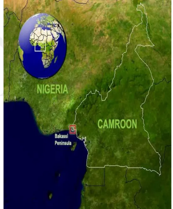
In the case study of Cameroon and Nigeria over the Bakassi peninsula, it will be important to first to give a preview of the location of Bakassi. Bakassi peninsula is located at the Gulf of Guinea located on latitudes 4°25 and 5°10N and longitudes 8°20 and 9°08E some 1000km of Mangrove swamp that extends from the Lake Chad basin. Bordered on the west by the Estuary of the cross river, on the north by the Akpayafe (also known as the Akpalkang) on the East by the Rio-del Rey Estuary and on the south by the Gulf of Guinea hal f submerged Island mostly occupied by fishermen settlers Annene (1970). With population of more than 250.000 of mostly Ibibio, Ijaw and Efik -speaking
people of Nigeria. It is located between the cross river and the rio -del Rey estuary at the point where the warm flowing east currents meet the north flowing current leading to the formation of foamy breakers and endless thunder ashore. The importance of Bakassi needs not to be further explain, as it is obvious besides being rich in maritime resources; the pen insula contains about 10% of the world’s petroleum and gas reserves Oluda (2011). Being as well a strategic military location at the core of the Gulf of Guinea, it also has direct link to two seaports of Calabar and Douala. The figure I below shows the location of our area of our focus.
1.1 Aim of Study
The objective of this study is to search for reasons why the Bakassi dispute did not turn into a war. The Bakassi peninsula dispute is very peculiar in nature comparative to other territorial conflicts. Generall y, many African states after independence have witnessed an increase in territorial disputes.
In most cases, these disputes turn to wars accounting for huge casualties and massive displacement of people. In territorial conflict between Sudan and South Sudan alone, more than 2.5 million people were displaced from it. One of the largest refugee camps (Dadaab Dadaab) is in Africa. Even though not linked to a point of focus here but most of this fighting is result from similar perspective. I will consider the cause of the Bakassi dispute even though it is being dueled upon by other writers, I will equally add my views into the existing motives already advanced. Nevertheless, it will be equally essential for me to talk about the actors involved in this dispute and the different roles the played in either escalating or resolving the Bakassi dispute. In addition, it will be important to look at a comparative approach of the Bakassi dispute with other territorial disputes within Africa,
Many authors have written on the Bakassi dispute however, striking enough, there has been very little attention on the why the dispute between these states did not result to war. This aspect of the conflict will be the point of interest in this study.
1.2 Importance of Study
Although significant amount of research has been conducted in this field, however in this case of territorial conflict, not so much time has been taken to view the subject from this perspective of why the Bakassi dispute did not resort to war. My study will bring give an appraisal why these states were able to resolve this issue without going to war.
My study will add to the already existing data in the case study of the Bakassi dispute and territorial conflicts in general. It will also be contributive in the framework of research and theory.
The research will help to guide diplomats and statesmen/women in ways of identifying areas of influence in trying to bring peace between states involve in territorial rivalry. Identifying features which attention should be given to peacefully resolve territorial disputes between states
1.3 Research Methodology
In this research, I will be using qualitative research methodology. I will be exploring and gathering data of existence works in this subject from interviews books, journals, articles and other online source of available data for analysis. Since there has been many data written in this field of study, my interest will be at looking almost all the available data in this field of study. As I go through the data, I will explore in depth the different views and perspective of other writers through the available data.
In addition, I will be conducting an empirical analysis of the available data , making interviews and from the analysis, relevant data sampled to support the findings from this thesis. The analysis of the data, which I have gathered, will be done with an iterative interpretation to come to concise findings.
1.4 An Outline of Presentations
Considering the study, I will begin with introducing the concept of territorial conflict with the other forms of territorial dispute in brief. I will proceed to identify the area of focus then locate the area of the dispute (Bakassi). Continue
with a brief history of the Bakassi Conflict from the origin until the settlement from the International court of Justice.
The next chapter will focus on the review of relevant literature from other writers within the topic area. Like I said before and I reiterated again, there has been a lot of research carried out in the subject of the “Bakassi dispute, so as we go through the literature of this topic we will see the different views presented by other writers.
To continue, I analyze and application of relevant theories of international relations to explain the Bakassi dispute. However, before looking at the theoretic view of the topic, I will shed some light on some concepts that re -occur throughout the study. This is to give the reader an understanding of these concepts in their application.
However, as it is a topic in within the framework of international relations, I will look at the actors involve in the dispute. In going through each actor, I will assess the level of their commitment to the dispute and their r oles played in the Bakassi conflict. In addition, I will bring in the views of residents in Bakassi on the causes of the issues through interviews I conducted.
In the fifth chapter, I will present reasons to support the argument why the Bakassi dispute did not lead to war. In this area, I will be bringing in data to support my argument for why these states did not turn to war to handle their differences over the Bakassi peninsula.
Finally, in the last chapter I will make conclusions based on the analysis of what I have presented and Recommendations on how to improve resolving this form of states dispute.
1.5 Research Questions
In light to better understand and approach this topic in a different perspective and give contributive views for research with this field, I will poise the following research questions.
In the Bakassi dispute whom are the actors involved in the dispute and what roles did they play in either escalating or de-escalating the Bakassi conflict?
Africa has/is witnessing many territorial conflicts over the continent. In view of the Bakassi dispute, what are the causes of the Bakassi dispute?
As uncommon as it is for territorial disputes with almost every “ingredient” necessary to push the conflicting parties to war, why did the disputing parties in the Bakassi dispute not resort to war?
From the resolution of the Bakassi dispute, what lessons can be drawn in intervention and settlement of territorial disputes between States?
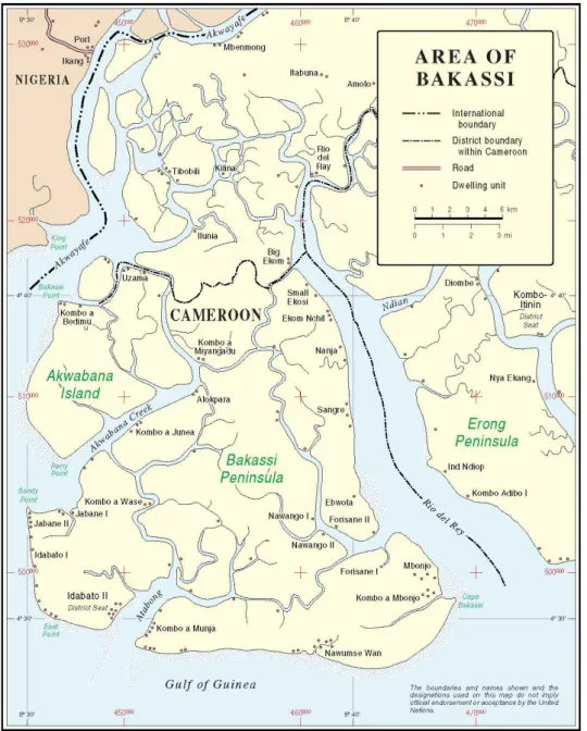
Figure 1.1: Source: Rigzone
Figure 1.2: Map of Bakassi showing boundaries.
Source:United Nations peacekeeping operations
(http://www.un.org/Depts/Cartographic/map/profile/bakassi.pdf ) Map of Bakassi showing boundaries
However, before going any further it is important that we consider historical background of the Bakassi dispute.
1.6 Hıstorıcal Background
Like most territorial conflicts, the Bakassi peninsula conflict did not just occur. Although the Bakassi conflict seems to have just caught the attention of a clear majority recently, the origin of this dispute falls back before there were territories like Nigeria and Cameroon, as we know then and prior to the independence of Nigerian and Cameroon on 1 October and 1 January 1960 respectively. The conflict stems from a long time ago when the Obong1 of Calabar signed a “Treaty of Protection” with the British (Nowa). In this treaty, the Obong gave his authority to the British to guarantee the British protection of his lands. At the time, there were a lot of inter- tribal battles and the best way he thought to protect his kingdom was to submit to British authority who had better weapons and could defend his lands from imminent threat from other tribes. On the 10 September 1884, the British agreed to extend their protection over the territory under the Jurisdiction of the Obong of Calabar and his chiefs. The Obong assured the British of not engaging in signing other treaties with other European powers in return for British protection. By signing this treaty, he ceded his authority and control of his lands. It should be noted that during this era this kind of ploy in gaining territorial control was very common. It should be marked that contrary to accord between two states these protectorates did not have any precise boundaries.
As the Berlin West African, conference2 of 1884-85 laid down modalities for the partition for Africa, Britain and Germany who had colonized and occupied Nigeria and Cameroon respectively at the time, preceded to define their various spheres of influence in Africa. On 15 November 1893, the two powers (Germany & Britain) delimited their spheres of influence in Africa and in what is today referred to as Bakassi. In this agreement, the colonial powers (Britain and France) gave away portions of territory to each other in ways to ease trade and navigation in their respective territories. Without consulting the Obong of Calabar, the British and German had no idea about what part of the land they gave each other belong. They put in place their own boundaries to suit their
1 Paramount traditional ruler in native Calabar region who control vast area with many subordinate
chiefs under his jurisdiction.
interest not knowing they were destabilizing and dividing people from common ethnic origins and disrupting ancient boundaries. This was later fortified by another agreement between the both powers in 19 March 1906 to cover Britain and German colonies that span from Yola right up to Lake Chad. Because of these agreements and other key declarations, in 1900, 1903 and 1906 that also brought military enforcement saw the creation of Northern, Southern Nigeria (the colony of Lagos included) as British colonies and Kamerun3 as German colony these protectorates became colonies. It should be noted that while these accords the area referred to as Bakassi peninsula had been subm itted in German control in Kamerun.
To further clarify according to Nowa, their boundaries and establish clear -cut navigation from Yola to the area between Kamerun, and Nigeria to the sea, they both signed “The Frontier settlement between Nigeria and Kamerun from Yola to the sea” in London on the 11 March 1913 later Nowa (2006). “The regulation of Navigation on the cross river” signed in Obokum April 12, 1913 by Hans Detzner representing Germany and W V Nugent representing Britain. This addressed a concise boundary between Britain and German Kamerun from Yola to the cross river. This agreement was followed with eight maps Chiahemen (2002) Britain was more interested in securing a continuous land access to the Calabar sea port since the Germans already had access to the Douala sea port they relinquished a considerable navigable fragment(portion) of the coast to the British. In return, the British handed over Bakassi and its environs to the Germans who were more interested in in Shrimps and in British assurance of not continuing further expansion eastwards. These agreements were done without consent of the local traditional rulers who governed these regions that bordered the two countries. These actions met no resistance from the local authorities about these arrangements made by their colonial powers without their permission because they posed no threats to the indigenous people. It should be recalled that during this moment Nigeria did not exist as it is now today but as separated territories known as the northern and southern Nigeria it was later in
3 Former appellation to present day Cameroon by the Germans during the German era of
the early stages of the ninetieth century that these two colonial factions were amalgamated to form the Nigerian protectorate. During this merger of the northern and southern colonies of Nigeria none of the traditi onal rulers the emirs, Obong or any other local chiefs were consulted about these boundaries. The colonialist to serve their economic interest and facilitate their exploitation of the resources mostly did this.
From 1913, the maps produced by British and German of both Nigeria and Kamerun vividly showed Bakassi in Kamerun when the First World War (WWI) broke out in 1914 became another turning point in the history of this region. Britain and France (Allied powers) attacked German colonies in Africa. After the defeat of Germany and the end of the WWI, Former German colonies were divided between Britain and France as stipulated in the treaty of Versailles4 under the supervision of the League of Nations as mandate territories5. “Cameroon” was divided into two parts the British and the French mandates. The British however claimed there was inadequate personal to administer their part of Cameroon as a separate colony. They decided to jointly administer Cameroon as an integral part of Nigeria, which was her colony because they shared a common terrestrial and maritime boundary. The area, which is known as Bakassi today, was in the British section of Cameroon. It should be noted that this was not a merger of the colonies but rather limited to an administrative fuse of the colonies. The British and French went further ahead to define their boundaries in Cameroon. They signed the Franco-British accord on the 10 of July 1919. Viscount Milner then Britain secretary of colonies represented the British and Henry Simon who was French minister of colonies represented France. The old boundaries in the 1913 Anglo-German accord were maintained and Bakassi was in the British Cameroons section administered as an integral part of Nigeria Ayim (2008).
To ascertain this, accord another treaty was signed on December 29, 1929 and 31 January 1930 between Paul Marchand commissaire de la repulique
4 Treaty which gave territories of former defeated nations of the first world war to the Allied powers 5 A system of control of former territories of defeated axis powers of WWI which gave authority to
Cameroun6 and Sir Graeme Thomson who was the governor of Nigeria Nowa (2006). This declaration was in turn ratified by both parties the British and French in a swap of notes between the French Ambassador in London and the British Foreign minister on January 9, 1931. Again, during this declaration the maps still shows Bakassi peninsula in British Cameroons. The development did not encounter any disapproval or protest by the people of Calabar or their ruler (obong). However, it should be noted that the local indigenes we not concerned about this allocations at the time because it did not affect their day-to-day lifestyle. The communal relation and activities remained uninterrupted. The sense of being a national to either state did not really depend on their local boundaries to the local people at the time. Equally, whoever affected by these decisions of the borderline did not really seem as a challenge at the time as identity
With the outbreak of the Second World War and the imminent failures of the League of Nations to maintain world peace and order, the United Nations organizations took over. The mandate system of the League of Nations was taken over by the United Nations trusteeship system that was approved by the general assembly of the United Nations with the intention of preparing the colonies for immediate independence. The trusteeship system however replaced the mandates system in British and French Cameroons. As a result, Nowa Britain divided her section of Cameroon into two parts the British northern and Southern Cameroons on the 2 of August 1946 Nowa (2006). There was a provisional order in the council of the United Nations that made tra nsitional details of the boundary between these regions now to be administered as separate integral parts of Nigeria (not part of it). The northern section of British Cameroons was attached to Northern Nigeria while the Southern part of British Cameroon, which contained Bakassi, was administered as part of the Eastern region of Nigeria. In 1954, the secretary for colonies in Nigeria issued a declaration defining the boundary of Eastern Nigeria and Southern Cameroons with Bakassi in Southern Cameroons distinctly from Calabar on the maps at the time. It should be noted also that the transition from the League of Nations to the United Nations, the UN ratified former League of Nations treaties and
boundary agreements. This was in accordance with the former Anglo -German agreements and Franco- British treaties on the 13 of December 1946 without any antecedent changes to the previous boundaries.
Based on the analysis and survey conducted by the United Nations trusteeship council,7 (The UN trusteeship council was created by the UN to supervise the level of developments made by former German colonies under British and French rule). The UN in March 1959, Nowa (2006) asked Britain and France to stipulate their plans for the people living in “Cameroons” and “Cameroun”. On the 1of January 1960 French Cameroun (Cameroun) gained independence from France. Based on the new statute of Cameroun there was need to reiterate the boundary between Cameroun and Cameroon based on the previous colonial agreements. On 1 October 1960 Nigeria gained independence from Britain and there was as well need to restate the boundaries based on the colonial agreements maps were produced to this effect and in 1960 these maps clearly showed Bakassi in Southern Cameroon.
The United Nations Trusteeship council mounted pressure on the British to clarify their wishes for the people of Northern and Southern Cameroon. From Ayim, on the 11th and 12th of February 1961 a plebiscite was organized to this effect for the people to determine where they wish to belong. Two separate plebiscites organized for the people in the North and they chose to become independent by joining the federal republic of Nigeria while the people of Southern Cameroon chose to join the La Republique du Cameroun (Independent French Cameroun) Ayim (2008).
After independence, Cameroon and Nigeria started having differences on the delimitation of the boundary. Many small skirmishes occurred but these confrontations were not violent in nature at the time. However, in May 16, 1981, Cameroon ambushed and killed Nigerian soldiers in three canoes. Nigerian reports on this incident said it took place in Akpa -Yefe (figure II) along the 1913 border while Cameroonian reports said the incident took place right in the Rio-del Rey area on the other side of the peninsula. Nigeria
7 A council created by the United Nations to survey the level of progress made by the territories under
demanded an apology from Cameroun but the later was hesitant insisting the incident took place in Rio-del Rey (Figure II). Eventually Cameroun issued an apology to Nigeria and she did not press the case any further as the Shagaria’s government did not much care about if the incident took place in Rio -del Rey but that Cameroun should simply apologize for it.
Moreover, conflict took a different turn with hostilities in the early 1990’s and the official introduction of a third party and other effort from regional organization (OAU) with the UN and ICJ occupying center stage. Following the clashes of 1994, Cameroon realized bilateral negotiation with Nigeria would not entirely settle the dispute even though it laid fundamental basis on which the ICJ could build its arguments. During the 1995 31st OAU head of states meeting in Addis Ababa, some African heads of state tried to get P aul Biya and Sani Abacha to dialogue since they had confidence in their authority to help resolve the dispute. Unfortunately, this was not successful. Due to this failure, it prompted the OAU to designate Eyadema, president of Togo to pursuit peace talks. On March 29, 1994, Nowa (2006) Cameroon tabled the issues of the Bakassi Peninsula to the ICJ for arbitration. As a result, Cameroun’s external minister Ferdinand Leopold Oyono and Nigeria’s Foreign Minister Chief Tom Ikimi from February 16-17, 1996 met in Kara, Togo to agree on ending hostilities in the peninsula and that both parties recognize the dispute was in the hands of the ICJ.
Furthermore, with the dispute in the International court of justice, after a series of long deliberations and study of facts, the ICJ in October 10, 2002 come to a resolution and it decided based on colonial archives in favor of Cameroun. The decision of the ICJ on the boundaries of the Bakassi region was ruled on the 1913 Anglo-German agreement. Based on this settlement, Nigeria was supposed to withdraw and transfer its administration in Bakassi peninsula to Cameroun’s jurisdiction. Cameroun on her part was supposed to remove its citizens from anywhere close to the new border between both states and the land boundary from the Lake Chad in the North and Bakassi in the South was delimited and signed by both states. To affect this ruling by the ICJ, then UN secretary general Kofi Annan used his good office, requested both heads of states to sign an agreement to commit to pursuit of peaceful transfer. In this
regard, the heads of state signed the Green Tree Accord and as accept to form a mix commission to take charge of the delimitation of the border and transition.
2 CHAPTER II: LITERATURE REVIEW
From Sango (2002), The rift over the Bakassi peninsula located in the Gulf of Guinea, is a heritage from imperialist, neocolonial and colonial rule in Africa. For colonialist like France, Britain, German, Spain and Portugal, it w as all about their respective interest and benefit from the African colonies. With this mindset, they proceeded to partition the continent in the 19th century among themselves to suite their interests respectively. However, during the partition of the continent, they did not take into consideration the people who lived there, their own boundaries, cultural beliefs and identities. As common as it is in Africa due to the partition, most people of similar ethnic groups found themselves separated into different countries. Neither showed expressed any concern nor formulate any initiatives to better the standards of living. Nonetheless, skirmishes over the rightful owner ship of the peninsula started as soon it was discovered that the peninsula was sitting around massive reserves of crude oil and gas. With this discovery, it was only then that either state started making allegations and counter allegations over ownership of the territory. Nigeria has its claims link to this peninsula attached to historic and coloni al rule while Cameroon with the 1913 Anglo-German treaty.
Ibekwe (2012) recounts origin of the Bakassi dispute between Cameroon and Nigeria emerges from the greed of the colonial powers, which they transferred to the two independent countries. The Bakassi peninsula was not a topic of territorial or economic controversy before or during the colonial era between these two Africans as they lived peacefully and together in a common local environment. He equally aligns the growth in population in both states af ter independence; the need for exploitation of resources was imminent. The governments of both states are highly dependent on natural resource for sustainable livelihood. With discovery of oil deposits by European multinationals it is from this that, the Bakassi disputes sprout. Due to the higher ration of the population of Africa that is dependent on natural resources, the roots of civil war hinges around this aspect throughout the continent. The
multinational companies who explore these resources have sho wn they are more interested in their profits and not stabilization or development of the continent. Jadesola (2012) Information accessible at the Federal Directorate of Survey (FDS) in Lagos displayed Bakassi peninsula as a part of Southern Cameroon, which was no longer a part of Nigeria as of 1961. With this, the minister for foreign affairs premised to forward a diplomatic note to the Embassy of Cameroon in Lagos slated No 570 of 27 1962, along with a map attached to it Jadesola (2012). This was to recognize the fact that the Bakassi peninsula was part of Cameroon. Notwithstanding, by 1965 Cameroon came up with territorial allegations on parts of the borderland of Danare and Boudan, a mixed technical commission was organized to trace the boundary. In the presidential era of Ahidjo in Cameroon, the Nigerian administration under military rule led by General Gowon came into peaceful engagement to establish a boundary commission to look for solutions to the boundary differences.
In allusion to Asobie (1998), international disputes are struggles among or across nation states. The rivalry might be between two or more governments to monopolize the exploitation of resources in disputed territories. This could happen if one state attempts to prevent another from accessing those resources that are necessary for its survival. To him, international disputes are struggles between or among social groups or more precisely social classes, clashing cross state boundaries. These social classes sometimes mobilize and utilize the different structures of the state-coercive and non-coercive to secure their ends. Moreover, these contests are invariably, for the control of some productive forces; materials of labor (land, minerals, raw materials); mechanism of labor, technology, finance capital, and labor power (trained or specialized human resources).
According to Anene (1970), she gives a detailed and interesting recount of the international borders of Nigeria. The work was not only concerned with the foreign acts of partition, but with the impact of colonial boundaries on the peoples in whose history the acts of portion were major intervention. This necessitated a multi-disciplinary inquiry into the ethnicity at the time the boundaries were made, the history of the different peoples, particularity the question of the history of political and economic inter group relationships, the
knowledge of these available to the treaty makers, and the consequences of their decisions. Though he recognized that the boundary zones of Nigeria and her neighbors were potential sources of boundary disputes, it did not put forward dispositions that may afford the best guide to a settlement of a miserable colonial heritage.
In another perspective, Rouke (2007) assessed at length the heritage of colonialism in Africa. He points out that the industrialization of the north was one factor that caused the colonization of the south in the late 1800s and early 1900s. He illustrates that Africa largely controlled by its indigenous peoples in 1878. However, by 1914 become almost totally subjected and divided into colonies by the European powers. The colonial boundaries had little relationship to the territories occupied by the various indigenous people, grouping nations together in some cases and dividing them in others. He further points out that within seven decades, virtually all the colonies recognized their independence, but many of the new countries (such as Rwanda) troubled by the legacy of trying to get two or more states to live peacefully in a single state. Though he did not particularly highlight the Bakassi Peninsula, he however showed the general trend of European colonial imposed boundaries on Africa.
To continue in another angle, Akanmode (2000) printed out that a population of Nigerians occupies the Peninsula that covers a marshy area of about 1000 kilometers’ squares, located in Cross River State. He further points out that if a judgment delivered by the ICJ on Thursday October 10, 2002, Akanmode (2000) was anything to go by, the inhabitants of the Peninsula may well be on their way to changing their nationalities from Nigerians the Cameroonians. In addition, his emphasis was on the paradox of the Peninsula. He maintained that the Peninsula is a community that subsists amid plenty-plenty of fish and oil deposits but ravaged by poverty. He further traced the dispute in the oil rich area between Nigeria and Cameroon form 1993, leading to loss of lives from military aggressions that Cameroon instigated. Although, this work deals extensively on the ICJ judgment, if fails to trace the origin of the dispute to colonial rule.
Odje (2002) in his own contribution offers a collection of documents on the creation of boundaries between Nigeria and Cameroon. He remarks that the
judgment of ICJ is binding but unenforceable in international law and at best is advisory, that the court has no enforcement powers, lacks the power of compulsion and it can only assume jurisdiction by consent of the parties. He further noted that for Cameroon to enforce the judgment of the ICJ, it must get the approval of the Security Council of the United Nations and that the United Nations does not allow the use of force for the enforcement of international law. He recommended that Nigeria should employ diplomacy and appeal for review of the judgment to protect the interest of the people of Bakassi, Cross Rivers state and Nigeria at large. His discussion of the problems of ICJ in enforcing its judgment and the weakened nature of its structure is of great importance, but he fails to trace ICJ ruling to the nature of its structure. However, his observations only centered on the validity of the judgment of the ICJ.
Oluda (2011) views also touch the outcome of the ruling by the ICJ citing the importance of the role and involvement of Kofi Annan in the deliberations for a peaceful transition of Bakassi from Nigeria to Cameroon. The green tree Accord and the transition process of Nigeria from the region and the establishment of administrative presence by Cameroon on the peninsula. Adding to this he also touched on the outcome of the ICJ ruling and significance to Nigeria. Oluda asserts the indigenes of Bakassi were disgruntled by the ruling and felt abandoned by their home government. Most people in the region cl aimed the former head of state Olusegun Obasanjo who was involved in the transfer of power to Cameroon did not have Nigeria at heart. In his own views, the implications of Bakassi’s transfers to Cameroon had other underlying consequences. The fear of losing the peninsula to Cameroon is equally a loss to an entrance to the Calabar port. This is because the Calabar port lies along the Calabar channel and in terms of the 1913 agreement used by the ICJ, this area belong to Cameroon. The consequence of this will be the loss of the multimillion Naira Export Processing Zone (EPZ). Since Calabar largely depends on this EPZ it will mean an even great loss to the region not to mention the millions of barrels of oil deposits found in area.
Moreover, in the mindset of Aghemelo and Ibhasebhor (2006), their own contribution sees colonialism as the source of boundary dispute among many African countries. They postulate that the Exchange of Notes of October 1, 1960
between Nigeria and the United Kingdom on treaty obligations and Diplomatic Note No. 570 of 1962 from the Ministry of External Affairs to the Embassy of Cameroon show that Nigeria acknowledged that Bakassi peninsula belong to Cameroon. They Aghemelo and Ibhasebhor (2006), also add that according to the definitions of boundaries by the Northern, Western and Eastern regions of Nigeria, on the proclamation L. N126 of 1954, Bakassi peninsula was not part of Nigeria. Instead, it was part of the former Southern Cameroon. They also added that the reason for increased military presence in the region had nothing to do with the indigenes of Bakassi but due to the discovery of Oil reserves in the peninsular.
Similarly, according to Berridge (2002) in his mindset of underscoring the significance of bilateralism says that bilateral diplomacy is relevant in the contemporary world in that usually when negotiations take place; it is much easier on a face-to-face basis whereby leaders do come together and discuss issues of importance. On these terms, it is easier to identify pertinent issues, which can help in understanding the difference expressed by each side. In effect, it will be easier to get to a compromise during negotiations. He further adds that heads of government may come into agreements but they might not always be with the national interest of the states involved.
In the same vein Allee and Huth in explaining the merits of bilateralism in dispute resolution offers that the two sides to a dispute have the flexibility to fashion out their desired terms of settlement, and at the same time exercise considerable control over the settlement outcome, by negotiating directly. They add further that in direct negotiations, both sides can also control, at least in part, the information concerning the bargaining process, and the timing of final settlement. They also added that domestic political aspects usually add significant pressure on government behavior in interstate dispute Allee and Huth (2006).
Furthermore, Mbuh (2004) also brings in another view for the reason why Cameroun and Nigeria were slowly moving to war is that both governments utilize the Bakassi border conflict as a means of switching concerns away from their poor human rights records. In both states, it is common to spell out many cases of severe human rights violation, resulting from the desperate aspirations
of the masses for genuine democracy and good neighborliness. This mindset backed by the works of Albert Mukong (1985), and as Executive Director of the Human Rights Defense Group (HRDG) in Cameroun, and Africa Con fidential all shade light on the human records of both nations Cameroun and Nigeria Mbuh (2004). In the both countries, there has been a gross abuse of basic human rights and fundamental values. The irony of this is the constitution of both states clearly states the need for people to exercise their rights. However, like many less developed countries, these aspects are mostly on paper and their applicability is nonexistent. In Mbuh’s view, the Bakassi issue provided a major opportunity to divert the high attention from international organizations on these states.
However, in Kah’s (2014) perspective he brings in the role of the military of both countries and how it fuelled the conflict or aided in the implementation of peace. In different phases of his analysis he views the level of military involvement however like Mbuh, he adds that this intensity and focus on the Bakassi was driven by other factors. Aligning with Mbuh he also asserts that the military involvement in the Bakassi dispute was a means to divert attention from the current deplorable governing in the respective countries. In both countries, there were almost semi authoritarian rule Cameroon had for close to 5 decades been rule by Two heads of states while Nigerian even though had changes in its government but was usually in radical forms by military coups. Therefore, the dispute over the Bakassi peninsula helped the governments to direct home attentions from deplorable government rule to need for gaining additional territorial space.
Fowler and Fanso look at the whole history of Cameroon right from encounter of the Europeans and the Cameroonian tribes to the creations of boundaries of todays Cameroon. The history of joint administration between parts of Cameroon and Nigeria and the demarcation of the boundaries of Cameroon, unravels background history between Cameroon and Bakassi and Nigeria , it helps in the construction of a background history of the disputed Bakassi peninsular. Fowler and Fanso(2009).
Tarlebbea and Baroni (2010) in the view presented the dispute and how the ICJ handled it to arrive at a peaceful solution and equally some aspects they add as
motives for the territorial conflict. The Cameroon government after failures of several attempts for a bilateral diplomatic solution decided to forward the dispute to the ICJ in 1994. Under the supervision of the UN secretary general Kofi Annan, he invited representatives of the respective states to be part of the negotiation process. It is intriguing that it took eight years of serious negotiation to arrive at a settlement for the ICJ. The representatives of the respective states took park in intensive review of facts, historical documents in a quest to arrive at a solution. In light with the proceedings, Nigeria alleged to the ICJ that the most effective way to determine the location of the Bakassi peninsula was through a democratic referendum. As she asserted that her claim for sovereignty was not based on the resource, location or attractions disposed in the peninsula but rather on the wellbeing of the Nigerians settlers in the region. On the 10 October 2002, the ICJ declared judgment on the fate of the peninsula in favor of Cameroon. The judgment of the ICJ was based on former colonial documents. The determined the boundary according to Tarlebbea and Baroni (2010), with the Thomson- Marchand and the Anglo-German declarations of 1929-1930 and 1913, respectively.
Bening looks at base of the Ghana-Togo border issues, France and Britain’s occupation of Togo its imminent partition after the first world war, drawing similarities with Cameroon and Nigeria and why the Ewe tribe eventually was more affected. Western Togoland was controled as an integral part of the Gold Coast and became incorporated later in to the new independent Gold Coast, on the other hand Eastern Togoland later became the Republic of Togo. His intent was to portray how the partition cut across the land of the Ewe people who had been in interaction with their Ewe brothers on the other side for a long time. Eventually the future boundary dispute between Ghana and Togo Bening(1983)
As seen from the assessments of different writers within the study of the Bakassi issue, significant contributions have been made to explain the iss ue. In different perspective analyzed by different authors, they established the possible causes of the issue on natural resources. The discovery of natural resources in the Bakassi peninsula cannot be ignored when looking at the causes of this territorial dispute. It is until the discovery of huge deposits of oil in the late
1960’s and early 70’s by European multinationals that this country openly alleged ownership of this area. Prior to this discovery, the Bakassi region was at its mercy of itself ignored and cut off from the rest of the world by both Nigeria and Cameroon. Considered remote, uninhabitable and marshy the region left less developed and seen equally as non-consequential to either Cameroon or Nigeria. Therefore, before this finding by the European multinationals, the 1913 Anglo-German agreement did not even occur or seem to have taken place. In another perspective, the role of colonial heritage from the scramble and partition of Africa has been the fundamental basis for the conflict over the Bakassi peninsular. In this perspective, the lack of regards for the African boundaries by the colonial powers and equally the non-consideration of their presence and involvement in the Berlin West African conference. These showed how severely they did not care about the locals when they decided their boundaries. Many as the main origin of this issue see the dispositions of the conference, transferring to the Cameroon and Nigeria boundaries. Most African boundaries even though arbitrarily arrived at have remained the juridical boundaries of these countries. This explains the next perspective of ethnic issues and differences as an important aspect when talking about the Bakassi dispute. As we will see subsequently in this study, African boundaries that existed before colonial rule were not drawn based on positions. Rivers, mountains or any other natural features did not determine boundaries instead they were based on spiritual and traditional believes and as they vary from one area to another. As it is in the Bakassi region and its environs, the people of this areas share common ethnic values. The basis of these shared ethnic similarities we will look further in this study and its effects on the Bakassi issue. A lot of concern already given in the role of the UN and its judicial organ the ICJ, and other aspects such as the steps taken to arrive at peaceful resolution. The aim of this thesis will attempt to establish a link and understanding in why Cameroon and Nigeria did not go to war over Bakassi. Although very unlikely for a peaceful solution as many other cases of territorial dispute between states within Africa suggest, this thesis will try to provide facts to support this argument in a very vivid manner to give a better understanding of why Cameroon and Niger ia choose peace with all the stakes involved.
3 THEORETICAL FRAMEWORK
The subject of international politics is an empirical science in which the most significant manner to appraise the value of any theory depends on how appropriately it describes states behavior. However, within the scope of the Bakassi issue and the arguments which I attempt to present in this thesis to support my views why the Bakassi dispute did not turn to war, I will be using the Liberal perspective of international politics better explains this perspective. In using this approach, our focus will be on the liberal paradigm. This theory will attempt an explanation of the behavior of these states and ultimately why the Bakassi dispute did not lead to war.
3.1 Lıberal Paradıgm
Under the liberal lens of international politics, states are viewed as important actors but equally, non-state actors like institutions, individuals and other organizations play a major role in providing room for states to conduct their affairs Voitti and Kauppi (2012). In view of the Bakassi dispute not going to war, the liberal perspective in this issue does not eliminate the possibility of it happening. However, several dispositions were available to these states to look for a solution that will not just be peaceful but mutual to all the actors involved. I will attempt an explanation from the liberal perspective on the role of institutions in bringing about peace on this issue. In addition, liberal view of economic interdependence, how it explained under this framework why these states did not fight over Bakassi.
For liberal theorist of international relations, States are important in the conduct of international politics however, they are not the main actors in some cases. One of the fundamental principles of the liberal views as Yurdusev (2006) presents is that special institutions may exist that may control states on how they conduct their relations with other states. In the Bakassi dispute and events leading to its resolution, we see how evidently this is. Both Cameroon and
Nigeria submitted their authority to this institution as it became the main actor within the dispute and instrumental in bringing about peaceful resolution of the Bakassi issue. Before going to a wide aspect of the involvement o f international organization, it is important to highlight the role of the African Union and its intervention even though to a limited extent. The African Union called both states to order and insisted both states had to continue to dialogue to pursue a peaceful solution.
In the same context, the presence and role of the UN in the Bakassi dispute, its intervention to bring about resolution of the conflict. This in line with the liberal perspective of global politics as the liberals coined the term. However still in the liberal context of other actors involving in global politics, it’s still challenging to describe under what circumstances and extent these other actors influence states behavior in interstate relations. The example of the Bakassi dispute somehow shows that level in liberal framework of this other actors (non-state actors) impact in global politics. The submission of both states to the authority of the UN in eliminating the possibility of war over the Bakassi peninsular. This actions and influence of the UN is directly in correlation to the liberal idea of existence of special institutions regulating states behavior in the international scene.
The role of the UN summarized under the following to understand fully how the liberal paradigm explains the Bakassi issue.
The UN through its main judicial organ the ICJ arbitrated in the Bakassi issue between Cameroon and Nigeria. In the arbitration provided by the ICJ, she listened to both sides of the argument from the Cameroon and Nigerian perspectives. However, within the confines of the ICJ the both parties also had provisions to negotiate almost every aspect of the arbitration process. The ICJ acted as a neutral party serving as a judge responsible for the peaceful resolution of the Bakassi dispute.
In addition, the ICJ man acting juridical organ of the ICJ in further supporting the liberal argument provided mediation to disputing parties. Allowing Cameroon and Nigeria, the opportunities to vent out the feelings regarding the Bakassi issue and explore their grievances. The role of the UN did not just stop
there; they continued working with Cameroon and Nigeria together or separately sometimes to bring about peaceful solution. In a more intensive extent, the UN implored the services of the former Secret ary General Kofi Annan who worked with the conflicting sides. His efforts in this area working with both Cameroon and Nigeria to explore their underlying interest in their varied positions paid off enormously. This is in line with the Paris agreement when he persuaded them to commit to the judgment of the ICJ before it made it public to both parties as they accepted to come to a consensus.
Furthermore, the Role of the UN also in the Good office it provided in the Bakassi issue. Article 98 of the charter of the UN provides that the secretary General in addition to acting in his capacity in all meetings of the general assembly, of the Security Council, of the Economic and social Council and the Trusteeship council shall perform such functions as entrusted to him by these organs. These in most cases include functions in the areas of prevention and peaceful settlement of disputes. Furthermore, article 99 of the charter states that the Secretary General may bring to the notice of the general assembly or Security Council cases that he feels can threaten international peace and security. Consequently, the role of the secretary General has included good offices. Acting in view of these dispositions, Kofi Annan provided Good office in ensuring a peaceful resolution of the Bakassi dispute. After the ICJ had already passed judgment on the Peninsular, the secretary General (Kofi Annan) summoned both disputing parties to New York. This was so to formulate a system of implementation of the judgment by the ICJ While this, Cameroon and Nigeria signed the Green Tree Accord to lay down modalities of peaceful transfer of authority over the peninsula. These views are just to support the arguments from the liberal perspective why the Bakassi dispute did not turn to war.
Moreover, in their view, states behavior is influences also if not modified by economic links or other forms of inter states connections. As John et al (2013) reiterates in Kant’s view, the three independent effects of Kantian elements understate believes of his prescription for peace since, interdependence, democracy, or the presence in inter-governmental organizations doesn’t really increase while the others remain constant. These connections can be in social,