Research Article
DESIGN SPATIAL AND NON-SPATIAL DATA MODELLING BASED ON THE
LADM STRUCTURE FOR LAND REGISTRY AND CADASTRAL SYSTEM IN
TURKEY
Zeynel Abidin POLAT
1, Mehmet ALKAN*
21İstanbul Arel University, School of Applied Sciences, Department of Real Estate and Asset Valuation
ISTANBUL; ORCID: 0000-0002-4127-3705
2Yildiz Technical University, Dept. of Geomatic Eng., Esenler-ISTANBUL; ORCID: 0000-0002-7542-5455 Received: 19.01.2018 Revised: 20.04.2018 Accepted: 29.06.2018
ABSTRACT
In land administration, spatial data manegement plays the important role of defining physical characteristics of land parcels in an accurate and discernible manner. A complementary part of spatial data infrastructure (SDI) is an effective information infrastructure that serves as the backbone of the land administration system. The paper provides a framework that supports adoption of spatial data modelling based on Land Administration Domain Model (LADM) for Turkish Land Administration System (TLAS). For this purpose, a spatial and non-spatial data model based on LADM is designed concerning the single space units subject to condominium in Turkey. The proposed data model is more comprehensive, capable of organising a wider range of spatial data, and should facilitate wider exchange of land information. The model is unique because it can support a very wide range of spatial units. Furthermore, the model was developed to help establish a national spatial data infrastructure LADM-based. To conclude, the developed model is a standardised model that could be used for local and international exchange of spatial and non-spatial data concerning land administration matters.
Keywords: Spatial data infrastructure, spatial data modelling, LADM, Turkish Land Administration System.
1. INTRODUCTION
Information models will enable efficient production, maintenance and use of suites of interoperable, standards based foundation spatial data [1,2] further explained that land administration (LA) is presently moving towards information management stage using information system especially to revolutionise collection, management, presentation and use of spatial information. LA includes both spatial-based information, e.g. on land parcels, and administrative-based information (non-spatial), e.g. ownership rights [3,4]. Moreover, LA has crucial relationships with other key registers in the SDI, some of which are spatial data, e.g. buildings or topography while others include non-spatial data, such as names of persons or campanies, addresses.
SDI is a “collection of technologies, policies and institutional arrangements to facilitate the availability of and access to spatial data.” This includes cadaster, land administration and land
* Corresponding Author: e-mail: [email protected], tel: (212) 383 52 95
Sigma Journal of Engineering and Natural Sciences Sigma Mühendislik ve Fen Bilimleri Dergisi
planning application s. Typical components of an SDI have also remained unchanged: (i) a repository of land and spatial data; (ii) a network; (iii) a geographic information system (GIS) for data handling and viewing [5]. The increase demand in land used and land activities all over the world had made the land administration and management became complicated. The increase in complexity of land required that LADM concept in land administration has an improved capacity to manage the existing 2D/3D [6].
The LADM makes easier to understanding the significance of data modelling in the domain of land, land administration and land management. The aim of LADM is to provide an extensible basis for the sustainable development and refinement of effective LA systems. The LADM is also a common language, which can support in development of tools for data exchange in and environment of SDI [7]. Based on this, the LADM could be used to document common aspects of land administration systems all over the world and contribute to sharing experiences and promoting good spatial data modeling practices [8]. Therefore, this study is a preliminary analysis of the necessities and requirements needed for implementation of spatial and non-spatial data modelling based on (LADM) land administration domain model. The data model developed based on LADM was used to store and manage both the spatial data and non-spatial data related to condominiums.
This study aims at presenting the concepts of LADM for the Turkish land administration country profile to harmonize spatial and non-spatial data for land registration in Turkey. Current studies mainly suggest new registration models and measurement systems for the representation and management of 3D cadastral data. Our study identifies the existing data structure, database and functionality gaps that are required to be resolved for the implementation of a spatial and non-spatial data management system in Turkey. This paper is structured as follows: Introduction (including spatial and non-spatial modelling in land administration) in section 1; an overview on Turkish Land Land Administration System (TLAS) (including cadastre and land registry) in section 2; Spatial and Non-Spatial Data Modelling in LADM Perspective in section 3; Case Study (including design spatial and non-spatial data model based on LADM for Condominium) in section 4; and finally in section 5 Discussions and conclusions.
2. TURKISH LAND ADMINISTRATION SYSTEM (TLAS) 2.1. Cadastral System in Turkey
The goal of existing cadastre system in Turkey is: “indicating the borders of immovable properties on the land and map, depending on the cadastral and topographic cadastral map of the country by country coordinate system, and determining their legal status; thereby establishing the deed registry as assumed by Turkish Civil Law No. 4721, and building the infrastructure of spatial information system”.
Cadastre system in Turkey includes cadastral mapping with land registry [9,10] and cadastre in Turkey is executed as two-dimensional and parcel-based [11]. Currently, the cadastre works in Turkey are executed by General Directorate of Land Registry and Cadastre in accordance with the Cadastre Law No. 3402 and Law on Change in Cadastre Law No. 5304. Title deed registries in Turkey are recorded by the title deeds registry office and the maps by directorate of cadastre. Two-dimensional graphic representations of many rights and limitations are available.
98% of two-dimensioned cadastre of Turkey has been completed [12]. Varied measurement methods (e.g. photogrammetric, orthogonal, tacheometric, graphic) and different coordinate systems and scales were used during these works [11]. As the result of cadastral works started in the beginning of 1900s, 9% of cadastral information was produced in graphic (not coordinate dependent), 14% in local coordinate system, 53% in ED50 coordinate system and 24% in ITRF coordinate system (Figure 1) [12]. Today, cadastral map sheets produced in different systems have been digitized and transformed into the country coordinate system. Digital mapping couldn't
be completed due to such different techniques and coordinate systems for cadastral structure used in time. Also available legal regulations don't give opportunity for the renewal of cadastre.
Figure 1. Distribution of cadastral data prepared in different coordinate systems [13]. 2.2. Land registry-land book in Turkey
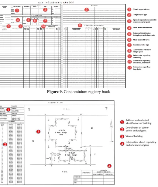
Turkish land registry system is consist of main and auxillary registers. Main registers are (1) land registry (in Turkish: Tapu kütüğü), (2) condominium registry (in Turkish: Kat mülkiyeti kütüğü), (3) transaction registry (in Turkish: Yevmiye defteri), (4) legal documents (in Turkish: Resmi belgeler). Real property records are kept page based in land book. There are two pages for each real property in the land book (Figure 2) and all the information about the real property (land parcel, individual and permanent rights) is recorded individual page of the land book. Condominiums related to spatial units are recorded in condominium registery which are a special part of land books. Transaction registry keeps transaction related detailed information by recording time (eg. hour and minute) that the transaction took placing. Legal documents about real property are authenticated contracts, plans, court decisions etc. related to the land title transactions.
Auxilary registers comprise of (1) ownership registries (in Turkish: Mal sahipleri sicili), (2) deposals registry (in Turkish: Aziller sicili), (3) corrections registry (in Turkish: Düzeltmeler sicili), (4) public goods registry (in Turkish: Kamu orta malları). Owner registry shows all recorded the real property which belong to an owner. It is recorded based on owners names so that the see the previously and currently owned estates of an owner. Deposals registry records deposed legal representatives. Correction registry provides information about of reason of correction that made in land books. Public goods registry records village or municipality name and area of the land (eg. prairie, pasture, lea) which is allocated to the public.
[DEĞER] millions [DEĞER] millions [DEĞER] millions [DEĞER] millions;
Figure 2. Registry pages of land book [14].
3. SPATIAL AND NON-SPATIAL DATA MODELLING IN LADM PERSPECTIVE 3.1. Brief Review of ISO 19152 Land Administration Domain Model (LADM)
The Land Administration Domain Model (LADM) received ISO official approval as an official International Standard on 1st November 2012, as ISO 19152:2012 [15]. LADM among other features, defines terminology for LA, based on different national and international land administration systems. The terminology allows a shared description of different formal or informal practices and procedures in different jurisdictions.
LADM will serve two goals, mainly [16] :
1. Provide a basis for the sustainable and effective development of LA systems;
2. Enable involved parties, both within one country and between different countries, to communicate, based on the shared vocabulary (that is, an ontology).
At the same time, LADM defines a reference model, covering basic information-related components of LA. Basic components relate to the following [16] :
1. Parties (eg. organizations and people ).
2. Basic administrative units, responsibilities, rights and restrictions related to ownership rights;
3. Spatial units (eg. parcels, utility networks, legal space of buildings) 4. Spatial sources subpackage (surveying).
5. Spatial representations subpackage (geometry and topology).
The Party Package consists of two subclasses. A Party can be a person, whether natural or juridical (i.e., a legal entity), or a group of persons identified in a transaction of rights relative to a BAUnit. A Party may be part of a Group Party and a Group Party may be a Party [17].
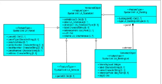
The administrative package (see Fig. 3) concerns the abstract class LA RRR (with its three concrete subclasses LA_Right, LA_Restriction and LA_Responsibility), and class LA_BAUnit (BasicAdministrative Unit). LA_BAUnit (basic administrative unit) allows the association of 0–N spatial units to Party against which a unique and homogeneous RRR is associated.
The Spatial Unit Package illustrates the physical entities of a land administration system. The package interests the classesLA SpatialUnit, LA SpatialUnitGroup, LA Level, LA LegalSpaceNetwork, LA LegalSpace-BuildingUnit and LA RequiredRelationshipSpatialUnit [18] (Figure 3).
The Surveying and Spatial Representation Package describes the spatial representation of a land administration system and the survey techniques used (Figure 3).
Figure 3. Basic classes of LADM [19].
The land administration has a key role in the establishment of a spatial/geographical data infrastructure. This importance of the land administration allowed a world-class LADM to be developed, spatial data standards to be developed [20] and basic classes and sub-classes to be determined [21] (Figure 3). UML class diagrams are used for the design of LADM data model. The model was divided to packets (components) during the design phase by grouping objects with different properties.
The basic data structure of LADM was developed in order to meet the demands of many different land administration systems (LAS) throughout the world. Thus the model allows representing spatial objects independently from geometry, and managing ownership, limitations and responsibilities in terms of data management holistically within the LAS [22]. Especially the rights called Rights, Restrictions, Responsibility (RRR) concerning land use, and modeling the relationship between the land and person are important. In this context, ISO 19152 standards were used for the LADM. The LADM's structure has characteristics that are applicable and integratable in many areas concerning the establishment of a spatial data infrastructure (SDI) for cadastre applications [23].
Moreover, SDI plays a key role in integrating many applications concerning ownership with LADM: Thus, LADM is very important to integrate the data from different LASs [21]. Thus, LADM allows data types and contents to be defined under standards in the context of the SDI that is generally created for land administration. The purposes of developing standards for AITM are 4-fold; (1) Creating an international common data sharing network within the model, (2) supporting software development for spatial land management and modeling under the Land Administration, (3) ensuring the modification and transformation of cadastral data under the LAS, (4) ensuring and maintaining data quality under the LAS [24, 25].
3.2. Spatial Data Modelling in LADM
The LA_SpatialUnit class was defined to represent spatial data during the design of LADM (Figure 4) . The most important property of this class is that it can represent 2 dimensional (2D), 3 dimensional (3D), and objects between the two (2.5D, liminal). This property is controlled through the dimension attribute. The data type of this attribute is LA-DimensionType and is defined in the LADM (Figure 5).
Figure 4. Classes of Spatial Unit Package [26].
Another important contribution of LADM to spatial data management is the LA_Level class that allows the management and visualization of the relationships between spatial data (topological, geometric, visual) (Figure 5). Thanks to this class, spatial units in different types (for example parcels, buildings, infrastructure facilities) and spatial units with different data structures (for example, text, point, unstructuredLine, polygon, topological) can be related in the same layer (level) and managed and visualized together.
The abstract LA_SpatialUnit class that represents spatial units in the LADM design has four different sub-classes with different properties. These sub-classes are LA_Parcel that represents cadastral parcels, LA_Building that represents the construction areas of buildings (2D and 3D), LA_BuildingUnit that represents independent units and LA_Network that represents linear infrastructure facilities (Figure 6). Since these four classes contain all the properties of the LA_SpatialUnit basic class (defined with their attributes), they are modeled as the sub-classes of this class. The unique (non-shared) attributes of these classes (that are not included in the AI_SpatialUnit class) are defined separately in each class. LA_Building and LA_SpatialUnit classes represent closely related buildings and spatial units, and the special relationship they represent is shown in the model by a connected relationship (Figure 6). This relationship means that independent units cannot be spatially defined without the building.
Figure 6. Sub classes of LA_SpatialUnit class. 3.3. Non-Spatial Data Modelling in LADM
Persons who are involved in all operations concerning registered spatial units, information concerning the Right-Restriction-Responsibility activities and liens of the spatial unit subject to registration, and all administrative activities are defined as non-spatial data. LA_Party, LA_RRR and LA_BAUnit classes are defined in the LADM to represente these data. LA_Party class is defined to represent persons who are involved in land administration in LADM. As can be surmised from the data type of the Party Identity attribute of this class (External Party), it is expected to provide the private and legal entity data from external data sources. Private persons, legal entities and groups having no legal entity but consisting of members can be represented with the LA_GroupPartyType attribute (for example family, tribe and communities) (Figure 7). Farmer, notary, surveyer, creditor, etc. persons who are involved in land administration are represented with the attribute LA_GroupPartyRoleType.
Figure 7. LADM Party package classes [26].
The LA_RRR abstract basic class is defined to represent rights (ownership), restrictions and responsibilities concerning the objects registered in the LADM. (Figure 8). This class has three important attributes [27,28]. The first one represents the share (share attribute) ratio for the rights, restrictions and responsibilities. The data type of this attribute (Rational) allows the dividend and denominator values that are traditionally recorded to be saved (Figure 8). The second attribute is the time period (timeSpec) attribute that is designed to record the validity periods of rights (ownership), limitations and responsibilities (Figure 8). This attribute allows timeshare applications and allows an important flexibility for managing future time-limited land use rights. The third attribute is the share check (sharecheck) attribute that emphasizes that the total of share ratios on the immovable must be 1 (Figure 8). LA_Right, LA_Restriction and LA_Responsibility classes are sub-clases of the LA_RRR class. In addition to the attributes they inherit from the basic abstract class, these classes can represent the right (ownership), rectrection and responsibility types with the type attribute they each have (Figure 8).
A BAUnit (used an abbreviation for basic administrative unit package) is an administrative entity comprise of zero or more spatial units (eg. parcels) against which one or more rights, responsibilities or restrictions are related, as contain in LA system. An example of a BAUnit is a basis property unit with two spatial units (e.g. an apartment and a garage) with same RRRs and parties attached (e.g. single owner) [29].
Figure 8. LADM Administrative package classes [27]
4. CASE STUDY: DESIGN SPATIAL AND NON-SPATIAL DATA MODEL BASED ON LADM FOR CONDOMINIUM
4.1. The Registration of Individual Parts of a Building is Subject to Condominium Law
This is a private property related to condominium, land share and the common areas in the main real-estate. All operations concerning condominium are conducted according to the condominium Law no 634. condominium and servitude are determined by showing the calculated value of the location and size of each of the independent units of the main real property subject to ownership, and the land share designated in the project subject to shared ownership principles [30].
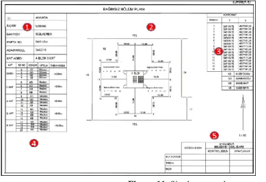
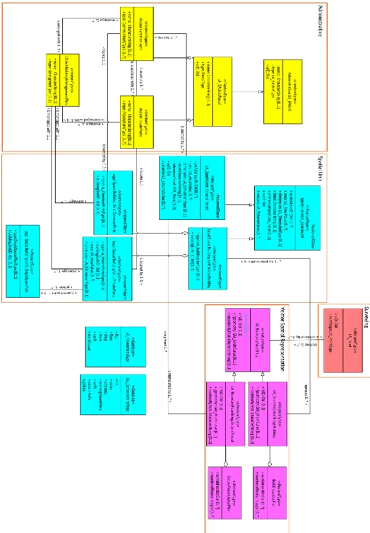
Condominium is registered to the condominium registry that is maintained according to the Land Registry Regulations (Figure 9). Unless otherwise specified by law, general properties concerning registration also apply to the registrations concerning the condominium registry. Annotations, servitude rights and lien rights (if any) concerning the independent property are registered in this registry. To register condominium, the single space plan of the immovable (Figure 10), layout plan (Figure 11), architectural project and management plan must be submitted.
Registration of separate parts (Common parts and private parts) of whole spatial unit (Building) in the land book is not possible without partition of building, which in legal terms means retention of real property as a single body. Section of the building creates ownership of a separate part of building (apartment, office space, garage, etc.) that becomes associated with proportionally shared part on the property.
Single space plan and layout plan on partition of real property (Figure 10) establishes size and shape of common and separate parts of a single real property (apartment, office space, etc.) and draws connections for reference purposes against the real property as a unit.
Figure 9. Condominium registry book
Figure 11. Single space plan 4.2. Design Spatial and Non-Spatial Data Model Based on LADM
This section investigates the importance of LADM in spatial and non-spatial data modeling, and a spatial and non-spatial data model is designed concerning the independent units subject to condominium. UML diagram is a good presentation of shows the entities, attributes, and relationship that have in a data management system. For this reason, the conceptual design was based on the basic UML diagram. To establish condominium, a management plan that binds all floor owners must be created. The LA_BAUnit:BuildingManagementPlan class was designed for
this management plan. This management plan is related to the
LA_BAUnit:BuildingManagementPlan class, BAUnit:CommonParts and BAUnit:CommonParts classes since it regulates the rules concerning single spaca units and common areas (Figure 12). Since the management plan concerns many single space units and common areas, these classes are related in a one-to-many relationship (Figure 12). One of the documents required to establish condominium is the single space unit plan. This plan contains the numbers for single space units, their floors, heights, facades, facade lengths, coordinates of corners and locations (Figure 12). The LegalSpaceBuildingUnit:SingleSpacePlan class is defined for single space unit plans. Since the single space unit plan is related to the single space units, this class is related to the LegalSpaceBuildingUnit:PrivateParts class (Figure 12). Another document required to establish condominium is the layout plan. The layout plan is the scaled map that shows all units in the
construction area. This plan is also related to the BuildingLayoutPlan and
GroundParcelLayoutPlan classes because it is related to the building and the parcel that contains the building.
5. DISCUSSIONS
3D cadastre and registration of real property in Turkey has been the subject of several studies. Çoruhlu et al. [32] examined the easement rights on the cultural heritage issues in terms of 3D cadastre Şimşek and Uzun [33] suggest 3D BIM model for value-based land share calculations. Çoruhlu et al., [34] determined the problems encountered in the registration of condominium and suggested solutions. Çoruhlu et al. [30] studied the establishment of horizontal and vertical condominium in terms of 3D cadastre in their works. In this study, a spatial and non-spatial data model LADM-based for real property is proposed. The Spatial Package presents the contents of a package related to spatial units in Turkish cadastral system (see Fig. 12). Within the Surveying and Representation Subpackage. There are three types of spatial objects: land parcels, buildings and single spaces in Turkish cadastre. All types of LA_SpatialUnits (2D, 3D parcels, buildings, or single spaces) share the same representation structure. A substantial necessity is that existing 2D cadastral data, whether topologically structured, polygons, unstructured, or simply point or textual descriptions should be easily included [3]. In addition to this, the LADM should also support the increasing use of 3D representations of LA_SpatialUnit, without putting additional burden on the simpler 2D representations.
According to [3] an important requirement is that there should be no mismatch between the parts of the domain that are described in 2D and the parts of the domain that are described in 3D. The proposed country profile based on the LADM provides a conceptual model for the spatial and non-spatial data relevant cadastre and land administration agencies in Turkey.
6. CONCLUSION
The studies in the literature are mostly focused on the measurement and registration of real property. This study has foreseen the use of a standard model for the management of spatial and non-spatial data. This study has foreseen the use of a standard model for the management of spatial and non-spatial data unlike them. The LADM is an international standard for the land administration domain and provides standardized class names for spatial and non-spatial (administrative) data. In other words, the LADM supports integrated spatial or non-spatial data modelling and representation of 2D and 3D spatial units. This study introduce the range of choice available in the LADM for representation of spatial units. Conformity of LADM for modeling spatial and non-spatial situations in Turkish land administration system was evaluated. This study proves the flexibility of LADM and the possibilities of using it for creating data modelling between spatial data and non-spatial data. Exchange of spatil data between traditional land administration systems in Turkey is possible now due to LADM standardisations. This designed model shows that LADM is a compatible template for further spatial data model development to meet country basic needs on land registry and cadastre.
We show that the LADM can be used to describe spatial and non-spatial data in Turkey, but that there are semantic differences, similarities and mismatches of classes and attributes between the LADM and the spatial data management system in Turkey. In conclusion, The LADM provides a very generic representation model for spatial data, as it has to be practicable global level, for kinds of spatial units (legal land parcels, legal spaces around buildings, legal spaces around networks/utilities). Further multidimensional (eg. 2D, 3D, and mixed 2D/3D) visualization and representation of spatial units are supported with different levels of accuracy: text-based, point-based, unstructured (line)-based, polygon-based or topology-based.
REFERENCES
[1] Box P, Simons B, Cox S, Maguire S (2015) A Data Specification Framework for the
[2] Williamson I, Grant D, Rajabifard A (2005). Land Administration and Spatial Data Infrastructures, Proceedings FIG Working Week/GSDI - 8,, April 16-21 2005, Cairo, Egypt.
[3] Van Oosterom, P., Groothedde, A., Lemmen, C., Van der Molen, P., Uitermark, H.
(2009). Land Administration as a Cornerstone in the Global Spatial Information Infrastructure. International Journal of Spatial Data Infrastructures Research 4: 298-331.
[4] Van Oosterom P, Lemmen C (2001) Spatial data management on a very large cadastral
database. Computer Environ Urban 25: 509-528
[5] LUCIAD (2014) ENABLING DISTRIBUTED SPATIAL DATA INFRASTRUCTURES
[6] Babalola SO, Abddul Rahman A, Choon TL (2015) A Brief Review of Land
Administration Domain Model and Its Temporal Dimension. J Advanced Rev on Sci Res 6(1): 1-15.
[7] Lemmen C, Van Oosterom, P (2014). LADM and its role in establishing cadastral
systems, In CADASTRE 2014 and beyond, 34-38.(2014), FIG publication 61. International Federation of Surveyors (FIG).
[8] Pouliot J, Vasseur M., Boubehrezh A (2012) How the ISO 19152 Land Administration
Domain Model performs in the comparison of cadastral systems: A case study of condominium/co-ownership in Quebec (Canada) and Alsace Moselle (France). Computer Environ Urban 40: 68–78
[9] Doner F, Biyik C (2007) Defining 2D Parcels in 3D Space by Using Elevation Data. FIG
Working Week 2007, TS 8G – Innovative Technology and Solutions in Land
Administration.
[10] Doner F, Biyik C (2013) Conformity of LADM for Modeling 3D/4D Cadastre Situations
in Turkey. 5th Land Administration Domain Model Workshop, 24-25 September 2013, Kuala Lumpur, Malaysia.
[11] Aydin CC (2008) Usage of Underground Space for 3D Cadastre Purposes and Related
Problems in Turkey. Sensors 8: 6972-6983.
[12] GDLRC (2015) 2014 Annual report. Strategy Development Department of GDLRC.
http://www.tkgm.gov.tr.
[13] URL-1 http://www.tkgm.gov.tr, accessed date: 07.06.2016
[14] Alkan, M., Polat, Z.A. (2016). Design and development of LADM-based infrastructure
for Turkey, Surv Rev, DOI: 10.1080/00396265.2016.1180777
[15] ISO (2012) ISO 19152:2012. Geographic information - Land Administration Domain
Model (LADM)
[16] Uitermark H, Van Oosterom P, Zevenbergen J, Lemmen C (2010) From LADM/STDM to
a Spatially Enabled Society: a Vision for 2025
[17] Choon TL, Zulkifli NA, Ujang MU, Chin TA (2015) Malaysian Land Administration
Domain Model Country Profile. Asian Soc Sci, 11(24), doi:10.5539/ass.v11n24p301
[18] Lemmen C, Van Oosterom P, Bennett, R (2015). The Land Administration Domain
Model. Land Use Policy 49: 535-545.
[19] Mirza JF (2010) Design And Development of Cadastral Database in The Context Of
Pakistan,
http://www.slideshare.net/FatimahMirza/graduate-research-thesis-defense-presentation
[20] Van Oosterom P, Lemmen C, Uitermark H (2012) Land Administration Standardization
with focus on Evidence from the Field and Processing of Field Observations, FIG
Working Week 2012, Knowing to manage the territory, protect the environment, evaluate the cultural heritage, Rome, Italy.
[21] Lemmen C, Uitermark H, Van Oosterom P, Zevenbergen J, Greenway I (2011) The Road
to A Standard Land Administration Domain Model, and Beyond, FIG Working Week 2011, Bridging the Gap between Cultures, Marrakech, Morocco.
[22] Inan HI, Yomralıoğlu T (2011) Arazi İdaresi İçin Konumsal Modelleme, hkm Jeodezi, Jeoinformasyon ve Arazi Yönetimi Dergisi, 2011/1, 104, 21-29.
[23] Lemmen CHJ, Van Oosterom, P, Uitermark HT, Zevenbergen J, Cooper AK (2011)
Interoperable Domain Models: The ISO Land Administration Domain Model LADM and Its External Classes, International Archives of the Photogrammetry, Remote Sensing and Spatial Information Sciences, Volume XXXVIII-4/C21, 28th Urban Data Management Symposium (UDMS 2011), September 28-30, Delft, The Netherlands. http://www.int-arch-photogramm-remote-sens-spatial-inf-sci.net/XXXVIII-4-
C21/31/2011/isprsarchives-XXXVIII-4-C21-31-2011.pdf.
[24] Lemmen C (2012) A Domain Model For Land Administration. PhD Thesis Technical
University Delft, ITC Dissertation 210, ISBN: 978-90-77029-31-2.
http://www.itc.nl/library/papers_2012/phd/lemmen.pdf.
[25] Lemmen C, Uitermark H, Van Oosterom P (2012) The Final Steps Towards an
International Standard For Land Administration, FIG Working Week 2012, Knowing to
manage the territory, protect the environment, evaluate the cultural heritage, Rome, Italy.
[26] Lemmen C, Van Oosterom P, Thompson R, Hespanha J, Uitermark H (2010) The
Modelling of Spatial Units (Parcels) in the Land Administration Domain Model (LADM),
FIG Congress 2010, Facing the Challenges – Building the Capacity, Sydney, Australia, 11-16 April, 2010.
[27] Lemmen CHJ, Van Oosterom P, Eisenhut C, Uitermark HT (2010a) The modelling of
rights, restrictions and responsibilities (RRR) in the Land Administration Domain Model (LADM). XXIV FIG International Congress 2010. Sydney, Australia.
[28] Inan HI, Sagris V, Devos W, Milenov P, Van Oosterom P, Zevenbergen J (2010) Data
model for the collaboration between land administration systems and agricultural land parcel identification systems. J Environ Manage 91 (12): 2440-2454
[29] Zulkifli NA, Abddul Rahman A, Van Oosterom P (2013) Developing 2D and 3D
Cadastral Registration System based on LADM: illustrated with Malaysian Cases, 5th
Land Administration Domain Model Workshop 24-25 September 2013, Kuala Lumpur,
Malaysia
[30] Coruhlu YE, Demir O, Yıldız O (2015) 3B Kadastro Nesnesi: Hava Hakkı ve Kat
Mülkiyetine Yönelik Gelişim Süreci Analizi. Ankara Barosu Dergisi 2015/3.
[31] Nasorudin NN, Hassan MI, Zulkifli NA, Rahman AA (2016) Geospatial Database For
Strata Objects Based On Land Administration Domain Model (LADM), The International Archives of the Photogrammetry, Remote Sensing and Spatial Information Sciences, Volume XLII-4/W1, International Conference on Geomatic and Geospatial Technology
(GGT) 2016, 3–5 October 2016, Kuala Lumpur, Malaysia.
[32] Çoruhlu YE, Demir O, Yıldız O, Çete M (2016) The relation between structured cultural
heritages and condominium towards 3D cadastre, Survey Review, 48 (351), p.1-13.
[33] Şimşek N.Ç, Uzun B (2017) Using 3D BIM Model For The Value-Based Land Share
Calculations, ISPRS Annals of the Photogrammetry, Remote Sensing and Spatial Information Sciences, Volume IV-4/W4, 2017 4th International GeoAdvances Workshop, 14–15 October 2017, Safranbolu, Karabuk, Turkey.
[34] Çoruhlu YE, Demir O, Yilmaz H (2017) Uygulamadan Tescile Kat Mülkiyeti: Sorunlar
![Figure 1. Distribution of cadastral data prepared in different coordinate systems [13]](https://thumb-eu.123doks.com/thumbv2/9libnet/4221406.66177/3.735.132.602.163.458/figure-distribution-cadastral-data-prepared-different-coordinate-systems.webp)
![Figure 2. Registry pages of land book [14].](https://thumb-eu.123doks.com/thumbv2/9libnet/4221406.66177/4.735.106.629.118.392/figure-registry-pages-land-book.webp)
![Figure 3. Basic classes of LADM [19].](https://thumb-eu.123doks.com/thumbv2/9libnet/4221406.66177/5.735.105.631.165.512/figure-basic-classes-of-ladm.webp)
![Figure 4. Classes of Spatial Unit Package [26].](https://thumb-eu.123doks.com/thumbv2/9libnet/4221406.66177/6.735.112.624.240.469/figure-classes-spatial-unit-package.webp)
![Figure 7. LADM Party package classes [26].](https://thumb-eu.123doks.com/thumbv2/9libnet/4221406.66177/8.735.102.632.118.513/figure-ladm-party-package-classes.webp)
![Figure 8. LADM Administrative package classes [27]](https://thumb-eu.123doks.com/thumbv2/9libnet/4221406.66177/9.735.101.635.119.402/figure-ladm-administrative-package-classes.webp)