THE REPUBLIC OF TURKEY
BAHÇEŞEHİR UNIVERSITY
AN EVALUATION OF HOUSING IN CASABLANCA,
MOROCCO: ANFA CASE
Master’s Thesis
NAJM-DINE EL OTMANI
THE REPUBLIC OF TURKEY
BAHÇEŞEHİR UNIVERSITY
GRADUATE SCHOOL OF NATURAL AND APPLIED
SCIENCES
ARCHITECTURE
AN EVALUATION OF HOUSING
IN CASABLANCA, MOROCCO:
ANFA CASE
Master’s ThesisNAJM-DINE EL OTMANI
Thesis Supervisor: ASSOC. PROF. DR. ALI DEVRIM IŞIKKAYA
THE REPUBLIC OF TURKEY BAHÇEŞEHİR UNIVERSITY
GRADUATE SCHOOL OF NATURAL AND APPLIED SCIENCES ARCHITECTURE
Title of Thesis: An evaluation of housing in Casablanca, Morocco: Anfa Case Name and Surname of Student: Najm-dine El Otmani
Date of Thesis Defense: 09.01.2018
The thesis has been approved by the Graduate School of Natural and Applied Sciences. Prof. Dr. Nafiz ARICA Graduate School Director I certify that this thesis meets all the requirements as a thesis for the degree of Master of Arts.
Assoc. Prof. Dr. Emine Özen EYÜCE Program Coordinator
This is to certify that we have read this thesis and we find it fully adequate in scope, quality and content, as a thesis for degree of Master of Science.
Examining Comittee Members Signature
Thesis Supervisor ---
Assoc. Prof. Dr. Ali Devrim IŞIKKAYA
Member ---
Assoc. Prof. Dr. Almula Köksal IŞIKKAYA
Member ---
ABSTRACT
AN EVALUATION OF HOUSING IN CASABLANCA, MOROCCO: ANFA CASE
Najm-dine El Otmani Master of Architecture
Thesis Supervisor: Assoc. Prof. Dr. Ali Devrim Işıkkaya January 2018, 88 pages
Starting from 1960s and 1970s, many developing countries experienced a significant migration of the rural population toward the urban areas mainly looking for job opportunities. This rural exodus caused an important concentration of the population in the urban centers, resulting in a sharp increase in the housing demand. Casablanca, the economic capital of Morocco, as it monopolizes 30 percent of the economy of the country, faced a high population pressure leading to a considerable imbalance in the housing market.
Due to the incapacity of the responsible authorities to provide the necessary infrastructure and housing for the population, which was growing in an unexpected rate, the lower-class population were incapable of getting an adequate housing. This situation pushed many low-income people to prefer settling in slums instead of suffering from an expensive rent. The continuity of the increase in the population density in the city led to the spread of the slums in many districts, until the authorities found themselves facing a huge number households living in informal housing assembled in many shantytowns sometimes located in the heart of the city.
The complexity of the situation forced the government to release a set of measures in 2004 to combat the inadequate housing assembled in a program called “Cities Without Shanties”. The program aimed to eliminate shantytowns in the most important Moroccan cities within 6 years (2004-2010), by providing an adequate alternative for the inhabitants of the slums. But because of the abstention of the shantytowns’ inhabitants to benefit from the alternatives provided, and the continuation of the housing crisis, the program was far from achieving its goal.
This study aims to analyze the housing sector in Casablanca and the situation in the shantytowns to better understand the phenomenon, and then cover the “Cities Without Shanties” program by going through its different phases and the actors contributing in setting
the policies and the ones responsible for the implementation and the application program to identify the shortfalls and the weaknesses of the program.
ÖZET
FAS KAZABLANKA'DA BARINMA DEĞERLENDİRMESİ: ANFA VAKASI
Najm-dine El Otmani Mimarlık Yüksek Lisans Programı
Tez Danışmanı: Assoc. Prof. Dr. Ali Devrim Işıkkaya Ocak 2018, 88 sayfalar
1960'lardan ve 1970'lerden başlayarak, birçok gelişmekte olan ülke, çoğunlukla iş olanakları arayan kırsal nüfusun kentsel alanlara doğru gerçekleştirdiği önemli bir göç yaşamıştır. Bu köyden kente akın, kent merkezlerinde önemli bir nüfus yoğunluğuna neden olmuş ve konut talebinde keskin bir artış meydana getirmiştir. Fas’ın finansal baş kenti olan Kazablanka, ülke ekonomisinin yüzde 30'unu elinde tutması nedeniyle, konut piyasasında belirgin bir dengesizliğe yol açan yüksek bir nüfus baskısı ile yüz yüze kaldı.
Yetkili makamların, beklenmedik bir oranda büyüyen bu nüfus için gerekli altyapı ve konutu sağlamadaki yetersizliği nedeniyle, alt sınıftaki nüfus yeterli oranda konut edinemedi. Bu durum, birçok düşük gelirli insanı, pahalı kira sıkıntısı yaşamaktansa gecekondu bölgelerinde yerleşmeyi tercih etmeye zorladı. Yetkililerin, kendilerini bazen kentin tam ortasında bulunan birçok gecekondu mahallesinde toplanmış, gayriresmi barınaklarda yaşayan çok büyük orandaki ailelerle karşı karşıya gelmelerine kadar, şehrin nüfus yoğunluğundaki artışın devam etmesi, birçok bölgede gecekondu mahallelerinin yayılması sonucunu doğurmuştur. Durumun karmaşıklığı, hükümeti, yetersiz barınma ile mücadele etmek için 2004 yılında "Gecekondusuz Şehirler" adlı bir programda biraraya getirilen bir dizi tedbir almaya zorlamıştır. Program, gecekondu mahalle sakinleri için uygun bir alternatif sağlayarak, en önemli Fas şehirlerinde 6 yıl içinde (2004-2010) gecekondu mahallerini ortadan kaldırmayı amaç edinmişti. Ancak, gecekondu sakinlerinin sunulan alternatiflerden yararlanmaktan kaçınmaları ve konut krizinin devam etmesi nedenleriyle, program amacına ulaşmaktan çok uzaktı.
Bu çalışma, bu olguyu daha iyi anlamak için Kazablanka’daki konut sektörünü ve gecekondu bölgelerindeki durumu analiz etmeyi ve ardından programın eksikliklerini ve zayıf yönlerini
belirlemek için farklı aşamaları inceleyerek ve bu politikaların belirlenmesinde katkıda bulunan aktörlerle ve programın uygulanması ve devamının sağlanmasından sorumlu kişileri araştırarak "Gecekondusuz Şehirler" programını ele almayı amaçlamaktadır.
CONTENTS TABLES ... ix FIGURES ... x ABBREVIATIONS ... xiii 1. INTRODUCTION ... 1 1.1 PROBLEM DEFINITION ... 1
1.2 MOTIVATION AND AIM OF THE THESIS ... 2
1.3 METHODOLOGY OF THE THESIS ... 3
2. INADEQUATE HOUSING : A COMPLEX GLOBAL PHENOMENON ... 5
2.1 LITERATURE REVIEW ... 5
2.2 Inadequate housing in Casablanca ... 7
3. THE CITY OF CASABLANCA ... 12
3.1 SOCIAL AND PHYSICAL EVOLUTION THROUGH HISTORY ... 12
3.1.1 Evolution under colonization ... 12
3.1.2 Evolution after the independence ... 27
3.2 THE HOUSING MARKET IN CASABLANCA ... 32
3.2.1 Housing demand ... 37
3.2.2 The imbalance of the housing market ... 39
3.2.2.1 Housing deficit ... 40
3.2.2.2 The factors behind the deficit ... 41
3.3 HOUSING POLICIES IN CASABLANCA ... 43
3.3.1 Production programs and partnerships ... 43
3.3.2 Financial system reforms ... 43
3.3.3 Institutional reforms ... 45
3.3.4 Regulatory and institutional failure ... 47
4. ANFA DISTRICT CASE STUDY ... 52
4.1 THE CURRENT SITUATION ... 52
4.2 THE ACTORS RESPONSIBLE FOR THE RESETTLEMENT ... 54
4.2.1 The public actors ... 55
4.2.2 The private actors ... 56
4.3 THE NEW PLANNING OF ANFA ... 57
4.4 SURVEY : ANFA SHANTYTOWN CASE ... 61
4.4.1 Aim of the survey ... 61
4.4.2 Data collection ... 62
4.5 FINDINGS AND EVALUATION OF THE SURVEY ... 77
5. DISCUSSION AND CONCLUSION ... 82
REFERENCES ... 89
TABLES
Table 3.1: The evolution of the foreign population in Morocco by nationalities between 1926 and 1951 ... 24 Table 5.1: The detailed situation of shanty towns after the end of the time limit of “cities
FIGURES
Figure 3.1: Map of Casablanca in 1907 ... 14
Figure 3.2: Map of Morocco indicating the “useful zone” ... 15
Figure 3.3: Map of Casablanca in 1912 ... 16
Figure 3.4: Urban planning of Casablanca made by Prost in 1915 showing the separation of the indigenous and the European cities ... 17
Figure 3.5: A view of the Habous district and the royal palace in 1924 ... 18
Figure 3.6: Moroccan houses in the new Habous district ... 19
Figure 3.7: A view in Habous district designed by Henri Prost ... 20
Figure 3.8: Map of Casablanca indicating the main districts in 1950 ... 21
Figure 3.9: Map of the vision of the expansion of Casablanca made by Michel Ecochard .. 22
Figure 3.10: Zoning map of Casablanca made by Michel Ecochard in 1952. ... 23
Figure 3.11: Apartment buiding constructed for Europeans in Rue d’agadir, Casablanca in 1928 ... 25
Figure 3.12: A Moroccan decorative style applied in a European apartment building in Casablanca ... 26
Figure 3.13: The location of the main shantytowns and their population in 1953 ... 28
Figure 3.14: Technopark in the south of Casablanca built in 20 ... 31
Figure 3.15: Ground floor plan of a Riad ... 33
Figure 3.16: Ground floor plan of a Dar ... 34
Figure 3.19: Shanties made of tinplate ... 37
Figure 3.20: Distribution of demand by region ... 38
Figure 3.21: Contrast between the villas and the shanties in Anfa, Casablanca ... 51
Figure 4.1: Inside Anfa shantytown ... 53
Figure 4.2: The residents of the shantytown assembled around the fountain to fill their buckets. ... 54
Figure 4.3: Global site plan of the New Sindibad project ... 59
Figure 4.4: Phasing plan of the New Sindibad ... 59
Figure 4.5: A view of the whole project of The New Sindibad project ... 60
Figure 4.6: A perspective view of the residential part of the new Sindibad project. ... 60
Figure 4.7: Percentage of the answers of question 1 ... 62
Figure 4.8: Percentage of the answers of question 2 ... 62
Figure 4.9: Percentage of the answers of question 3 ... 63
Figure 4.10: Percentage of the answers of question 4 ... 63
Figure 4.11: Percentage of the answers of question 5 ... 64
Figure 4.12: Percentage of the answers of question 6 ... 64
Figure 4.13: Percentage of the answers of question 7 ... 65
Figure 4.14: Percentage of the answers of question 8 ... 65
Figure 4.15: Percentage of the answers of question 9 ... 66
Figure 4.16: Percentage of the answers of question 10 ... 66
Figure 4.17: Percentage of the answers of question 11 ... 67
Figure 4.18: Percentage of the answers of question 12 ... 67
Figure 4.19: Percentage of the answers of question 13 ... 68
Figure 4.21: Percentage of the answers of question 15 ... 69
Figure 4.22: Percentage of the answers of question 16 ... 69
Figure 4.23: Percentage of the answers of question 17 ... 70
Figure 4.24: Percentage of the answers of question 18 ... 70
Figure 4.25: Percentage of the answers of question 19 ... 71
Figure 4.26: Percentage of the answers of question 20 ... 71
Figure 4.27: Percentage of the answers of question 21 ... 72
Figure 4.28: Percentage of the answers of question 22 ... 72
Figure 4.29: Percentage of the answers of question 23 ... 73
Figure 4.30: Percentage of the answers of question 24 ... 73
Figure 4.31: Percentage of the answers of question 25 ... 74
Figure 4.32: Percentage of the answers of question 26 ... 74
Figure 4.33: Percentage of the answers of question 27 ... 75
Figure 4.34: Percentage of the answers of question 28 ... 75
Figure 4.35: Percentage of the answers of question 29 ... 76
Figure 4.36: Percentage of the answers of question 30 ... 76
Figure 4.37: Condition of slums in Anfa shantytown ... 78
Figure 5.1: Increasing the number of stories and decreasing the lot surface area ... 86
ABBREVIATIONS
CAPMAS : The Central Agency for Public Mobilization and Statistics (Egypt). HCP : The High Commission for Planning is the Moroccan commission
which is officially responsible of making accredited statistics. OHCHR : The Office of the United Nations High Commissioner for Human
Rights which is the principal human rights unit of the United Nations.
1. INTRODUCTION
1.1 PROBLEM DEFINITION
The spread of the informal housing in Casablanca has reached almost all the districts of the city, mainly because of the imbalance of the housing market since there is a lack of
affordable housing for the lower-class; therefore, a set of effective measures should be held by the local and the national actors to conduct short term intervention as well as long term strategies aiming to combat the inadequate housing.
Since the 1960s, Morocco has experienced a strong rural exodus. As in many other developing countries with advanced economic transition, the urban population increased sharply from 29 percent in 1960 to 41 percent in 1980, reaching 54 percent in 2002, which has been too fast to be fully controlled. Each year, nearly 240,000 people migrate from the countryside to the cities, and a large part of this population, is hoping to temporarily set up in inadequate housing. The phenomenon of inadequate habitat is becoming more widespread every year. The demand for housing is rising regularly, while the lack of viable and affordable land continues getting worse. (The World Bank, 2016)
Casablanca, as the economic capital and the largest city in Morocco, monopolizes 30 percent of the Moroccan economy, which made it the first destination of the immigrants who are mostly looking for job opportunities. So, the city faced a high rate of housing demand that the authorities were not ready nor able to respond, resulting in an imbalanced housing market and an increase in the houses prices.
Facing the State's inability to provide accommodations that meets the large housing demand in Casablanca, the lower-class population, composed basically from rural migrants, took the initiative and started constructing their houses themselves. The situation ended up by the creation of several shantytowns, that some of them are today located in very advantageous
of the shantytowns and eliminating the existing ones, the government provided a set of measures assembled in a national program called “cities without shanties”. Unfortunately, the program did not meet the needs of a large class which is supposed to benefit from its assistance due to the unconformity of the propositions with their requirement.
The program aimed to provide suitable housing in a low price destined to the resettlement of the shantytowns’ inhabitants, who have to pay a 40 percent contribution from the house’s price. Most of the resettlement projects are located in the peripheries of the cities, forcing the beneficiaries to live in semi-rural areas as the houses are situated in zones lacking from the basic infrastructure equipments. So, the inhabitants find themselves forced to move many kilometers for the simplest needs, whether it is for education or for working or even for the health facilities.
1.2 MOTIVATION AND AIM OF THE THESIS
The right to adequate housing has been recognized by The Office of the United Nations High Commissioner for Human Rights (OHCHR, 2015) as an integral part of the right of everyone to a decent standard of living. The suitability of a habitation is not limited in offering only four walls and a roof, but it must meet, at least, the following criterias:
a) Security: housing is not suitable if its occupants do not have a degree of security of tenure that provides them with legal protection against forced evictions, harassment and other threats.
b) The existence of services, facilities and infrastructures: housing is not suitable if its occupants do not have drinking water, sufficient sanitation facilities, a source of energy, heating and lighting.
c) Payment capacity: a dwelling is not suitable if its cost threatens the resident’s benefit of other fundamental rights.
d) Habitability: a dwelling is not suitable if it does not guarantee the physical security of the occupants or does not provide sufficient space as well as protection against cold, humidity, heat, rain or wind.
e) Location: Housing is not suitable if there are no nearby employment opportunities, health care facilities, schools, babysitting services and other social equipments.
The issue is that even in some metropolitan cities most of the criterias mentioned are not respected and taken into account. It is the case in Casablanca, where a large class of the population is living in inadequate environments which lack the basic characteristics of a suitable housing.
In order to combat the phenomenon, the authorities proposed a set of measures combined in a program called “cities without shanties”. The options imposed on the shantytowns’ inhabitants were also lacking some of the criterias which pushed the majority to refuse moving from their shanties.
The thesis aims mainly to go through the causes of the spread of the shantytowns and the measures taken by the government to combat them in order to highlight the shortfalls of the programs whether in formulating the procedures and policies or in the implementation of the measures. Another objective of the thesis is bringing out the reality of the situation in shantytowns and showing how the measures can be more effective if the inhabitants participate in the decisions whether in the formulation or in the implementation as they are the most concerned actors of the program.
1.3 METHODOLOGY OF THE THESIS
To be aware of the shortfalls of the intervention made to combat the inadequate housing in Casablanca, first of all there is a need of studying the physical development of the city of Casablanca as well as the housing market and its specifications. Second, analyzing the measures taken and the way the government is combating the inadequate living by going through defining all the actors participating on the implementation and specifying the responsibility of each of them in order to reform the measures and develop the methods of
sample of the shantytowns inhabitants touching their background, their way of living, their living conditions, their aspirations and their point of view of the solutions proposed and the measures taken.
In order to make a useful analysis the study will go through the expansion of the city of Casablanca as well as the statistics showing the development of the population. An analysis of “cities without shanties” program will be done covering all the steps and identifying the role of every actor in each one of them and his responsibility. In the last part of the study, a questionnaire destined to the inhabitants of a shantytown in Casablanca will be adopted in order to gather a data that can be dependable in understanding the background, the current situation and also the point of view of the inhabitants considering the measures taken and what can be the most suitable option for them.
Studying the above-mentioned points will help to better understand the situation, thus facilitating the suggestion of better scenarios than the current propositions.
2. INADEQUATE HOUSING : A COMPLEX GLOBAL PHENOMENON
2.1 LITERATURE REVIEW
The concentration of the population in the urban centers is a challenging phenomenon for most of the developing countries, according to many authors, as it has many effects on the unemployment, on migration, on the neighboring areas, and directly and indirectly on the poverty, which results in more production of the slums.
The size of the country is an important explanatory factor for the degree of urban concentration. The relationship is explained by Lösch (1954) in his market area theory, affirming the fact that a larger area encourages the multiplication of the number of production centers in order to reduce the costs of transportation. Another geographic variable is taken into account by an indicator of agricultural land dispersion, in order to capture the effect of the spatial diffusion of the market on the degree of concentration. This size effect on concentration is also confirmed by Henderson (2000) and Moomaw and Shatter (1996) through a population size variable. As for Ades and Glaeser’s (1995) results, standing out from the other authors, when the area of one country is 10 percent larger compared to another, the primate population tends to be 1.2 percent higher. The authors explain this positive relationship by the fact that the larger area of a country corresponds to a lower density of the population and therefore to an increase in transport costs to supply peripheral regions. The higher concentration is also related to the early stages of the development and democracy of a country. Many researchers related the urban concentration to the decentralization of the power and authority, and even with democracy. Starting with Henderson (2000), who invented a variable "federalism degree" representing the degree of local autonomy, as a higher degree of authority decentralization affecting the concentration downwards. As for Moomaw and Shatter (1996), they have explained the positive effect on primacy when the primate city is also the capital of the country. Following the same theory, Ades and Glaeser (1995) estimate that the primate city is on average 42 percent larger when it is also the capital. they also discussed and predicted that countries with dictatorial regimes have primate cities
the so-called "new democracies" (first under a dictatorial then democratic rule from the 1970s), the primate cities are on average 40 percent larger than those of the countries under a regime democratic for a longer time.
The urban concentration has been related directly and indirectly to poverty. As mentioned by Cali and Menon (2012), the urban concentration has direct effects on the poverty through employment, as the big cities provide better job opportunities to the neighboring areas, which will help the production of other jobs related to the consumption and trade in those areas needed for the growth of the population. On the other hand, Card (2009) and Ottaviano and Peri (2012), assured that the fact that the workers are moving from rural to urban areas looking for better job opportunities will give rise to the competition in the working market between the existing workers and the migrants, which may have an impact on poverty by the decrease of the salaries. Glaeser, Kahn and Rappaport (2008), mentioned the urban concentration may have an indirect impact on the poverty by generating overcrowding and environmental deterioration, which effect the production negatively resulting in the rise of poverty. Another impact on the neighboring areas, is the effect on the prices of the lands in the rural zones near the metropolitan cities. This kind of increase in the prices might be beneficial for the landowners and investors, but may be disadvantageous for people renting lands or workers in the agricultural sector, since the expenses will increase (Cali and Menon 2012).
For the less developed countries, the urbanization and the urban concentration are always challenging concerns because of the lack of the infrastructure and the lack of the ability to provide the needs of the high rate increase in the population as cited by Cohen (2006) and Montgomery (2008). Consequently, according to the United Nations (2015), the inability of supplying enough infrastructure and housing for the increase of the number of the population in the undeveloped or even developing countries, resulted in the spread of the slums. Yet, the number of people living in slums reached 1 billion and is still increasing.
2.2 Inadequate housing in Casablanca
Located in North Africa, Morocco is bordered on the north by the Mediterranean Sea, on the east and southeast by Algeria, on the south by Mauritania and on the west by the Atlantic Ocean. As the other countries, there are regions in Morocco with different development speeds, regions more favored than others, at a point that the country has been divided by the French colonizers into useful and useless Morocco (1912). The notion of useless Morocco had been emitted by the French colonizers during the period of protectorate, making the difference between the regions with strong economic potential: agricultural, mining, and maritime, and the other regions, without appreciable natural resources. The Protectorate developed and exploited the useful regions and abandoned the others. And after the departure of the French protectorate in 1956, the government tried to develop them in order to improve the standard of living of their inhabitants.
The process of decentralization in rural development started in the 1960s and 1970s, targeting both social (health, housing, education) and productive infrastructure (roads, irrigation, warehouses), but it seems that in the absence of a precise timetable the process has not really been launched, other than in the form of a deconcentration and a delegation that are quite modest, which leads to an uncontrolled rural immigration.
Casablanca is a city located in the center-west of Morocco, and it’s the economic capital and the largest city of the country, located on the Atlantic coast, about 80 km south of Rabat the administrative capital. The location of the city in the coastal region with an important port built in 1912, and in the center of the “useful Morocco” near the world’s biggest phosphate deposits made it a privileged destination for Moroccan traders, investors and foreigners, but mostly for people coming from poor and rural areas looking for job opportunities. The potentials of the city made it the first destinations of immigrants in the country.
As a result of the urbanization, cities in the developing countries have been developed and transformed unlike the villages. But the migrated villagers kept on practicing the same characteristics of the village because of economic reasons and didn’t adapt to the cities reforms, which led to the spread of illegal inappropriate housing.
Istanbul as an example, has undergone a rapid migration from rural areas, which caused an incontrollable population growth resulting in informal housing called “gecekondu”. Today, the population of Istanbul is more than 14 million and it contains more than 2.4 million houses with 33 percent of illegal houses. Because of the urban development, the government worked on creating an alternative by providing houses located on the periphery of the urban area, and supply many paying options according to the conditions of the beneficiaries, for instance whether they own the land where they built the inadequate houses or not. (Sabah, 2011)
Moving to South America, precisely to Sao Paulo in Brazil where one fifth of its population estimated in 17.5 million is currently living in inadequate housing conditions, like the shanty towns that they call “Favelas” which are located on the hillside and have a panoramic view while wealthy people are living along the bottom in less favorable conditions, but the two communities are next to each other which creates a social contrast. The authorities launched a program 15 years ago -in parallel with providing social housing in the periphery of Sao Paulo- to rehabilitate favelas, helping residents improve their housing and providing basic services such as water, electricity and public transport. (Le Point International, 2012) Cairo in Egypt could be a good example from Africa as it’s surrounded by a belt of 80 slum areas, and according to a recent report by the Central Agency for Public Mobilization and Statistics (CAPMAS), 3.13 million among 9.6 people in Cairo are living in inadequate housing called “Ashwaiyyat” in Egypt. The Egyptian government backed a campaign called “Campaign of one billion pounds” to collect funds in order to provide houses with suitable living conditions for people in “Ashwaiyyat” starting from Cairo as it contains the highest rate among the Egyptian cities. (Masress, 2012)
Being aware of the facts and the way the strategies are implemented is a major action that helps evaluate what have been done and determine the shortfalls of every phase of the program and define the responsibility of each actor in order to reform the measures and develop the interventions.
In Casablanca, there is an identical dramatic social situation of Sao Paulo case experienced in Anfa, one of the most upscale districts of the city, even of Morocco. Anfa district is known for its luxurious villas and palaces. In this little end of the capital there is neither pollution nor horns. Private properties are surrounded by palm trees and plants. The more you climb up the hill, the more it is chic. But inside this neighborhood considered as the preserve of the fortunate, there are also many shantytowns that represent and characterize the real misery, and feel like an open-air dump where there are children playing barefoot in the middle of garbage. The population of Anfa district is more than 120000 and people living in shantytowns are around 25000 which means 20 percent of the population are living with a lack of basic services, no sanitation system, and sometimes with no access to water or electricity, and their barracks are build or covered by wooden or metallic sheets (La Vie Eco, 2016).
The occupation of mostly private expensive lands, located in the middle of the city, and the way people are living without the minimum of the living conditions, and also the distortion of the view and the beauty of the city pushed the government to decide to combat the extension of the inadequate living and provide an alternative for people in slum houses. The government decided to provide a new housing type destined to the lower-class population in order to solve this problem and move people from the insalubrious housing to an appropriate living.
The hypothesis of social housing in Casablanca has already been formulated under the French protectorate in 1914 by Henri Prost, who proposed a new indigenous district allowing the transfer of workers and the destruction of insubordinate slums. In 2004, the government launched a new approach to combat the problem of insalubrious housing called “Cities Without Shanties” Program (villes sans bidonvilles) which is focusing on producing the shanty town curbing units and accompany them by the demolition of corresponding shacks. For the achievement of the program the government worked on the mobilization of the public land, the improvement of a legal framework that provides better conditions of investments, and working on conventions with partners and operators from both public and private sectors.
The solutions proposed to the inhabitants of Anfa shantytown, as all of the other shantytowns’ residents, were not accepted by the majority since it was a retreat for them to move from the center of the city where all the necessary equipments are available, to a small house in a semi-rural area.
Despite the practical procedures conducted by the government, many obstacles faced the execution of the new approaches such as, the difficulties in the land management because of the high cost or unavailability of some lands, the limited financial resources of the households, and the absence of a national database of households who need to benefit or the ones who have already benefited from the program.
The majority of the houses built for households affected by resettlement projects in Casablanca are constructed in the periphery of the city, so most of the households are excluded outside the city, compared to their sites of origin, and that can create a spatial and socio-economic exclusion of the population. In addition, displacement to peripheral areas is generally declined by beneficiaries. The distance, with the weakness of the financial situations of the households are factors characterizing the operations of resettlement.
In fact, it is difficult to talk about a real habitation and urbanism policy. Indeed, the actions that had been initiated previously were mostly very limited. The housing projects carried out through direct government intervention, were more like isolated and scattered initiatives and had no significant impact on the considerable housing problems in Casablanca.
The measures adopted have mobilized significant funds, and the government authorizes both public and private operators for the constructions. Despite the programming of financing the construction of housing and the public facilities by the government, the operators in charge face many problems since the funds do not grant in advance for the financing, the amount of construction of the equipment concerned is released after the attestation of conformity, which obliges operators to pre-finance in full the construction of the public facilities of their program. This may explain the delay in building these infrastructures.
The augmentation in the number of slums is due to the raise of the population of Casablanca, but also because of the rejection of a part of the beneficiaries which makes them look for
returning to the shantytown and abandon the houses they have been offered for rent or resale. What pushed people who benefited from the program to refuse it is the new data that emerged and which can change their daily lives, as it becomes necessary for them to pay water and electricity bills, the monthly credits, and extra transportation fees. Another cause is taking them to not very urbanized areas that are insufficiently equipped where they can’t be independent from Casablanca, whether for work or for medical treatment or even for education. So, it is necessary to solve the issue in an urban scale and not by only rising the number of social units; but by focusing on the reason that makes people live in inadequate houses which is following job opportunities.
3. THE CITY OF CASABLANCA
Economic heart of Morocco, the city of Casablanca is a capital financial center. Known worldwide for its diversity and culture, Casablanca brings together the largest Moroccan and foreign companies. Many Europeans settle there every year to start their own business in international trade and real estate. Rich in its history, the city of Casablanca knows a rapid rise from the end of the French protectorate and is positioned internationally in tourism, economy, industry and transport. Casablanca contains a concentration of 60 percent of the largest Moroccan manufacturing establishments, it covers the needs of the whole country in food, metallurgy and chemistry, alongside them there are also the textile, leather, wood and paper industries. The economic capital also contains the largest factories in the country producing the sugars, cements and Tobacco. There is also The Casablanca Stock Exchange, the third largest financial center in Africa, which plays a central role in Morocco's economy. Between modernity and tradition, in Casablanca, there are the “souks” that are traditional commercial areas mostly full of traditional handicraft merchants, but also modern shopping centers where all the famous brands are assembled. (Serge, 1951)
Open on the Atlantic and with a strategic geographical position, Casablanca is at the crossroads between the main Moroccan cities. Close to the capital city Rabat and Marrakech and halfway between Tangier and Agadir.
3.1 SOCIAL AND PHYSICAL EVOLUTION THROUGH HISTORY 3.1.1 Evolution under colonization
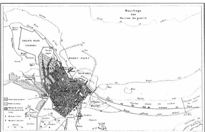
Before the French Protectorate, Casablanca was just a small town, divided into three main districts (figure 3.1):
a) The Medina, today old city of Casablanca, where the Prince chose to resuscitate in by 1790, located on the seaside and surrounded by walls fortified by a place of canons (Sqala). Located on the eastern and north-eastern part of the city, the Medina collected administrative buildings (court, customs, foreign consulates) and city mansions
(residences of the Governor, Europeans, officials and main traders of the city). The district is characterized by the urban type of the Arabian Medina, namely alleys rather than streets, dead ends rather than squares, and a compact and concentric structure rather than a linear one.
b) The Mellah, is the Jewish neighborhood, located in the South and South-West of the city, welcomed the Moroccan Jewish population. Actually, only a small part of it remains, near the Medina. The area collected a mixed population until 1948, made up of Jewish people and Muslims. After that, the migration to Casablanca became no more than a stage to Israel for Jewish people. The neighborhood was created to follow the idea of the regime of protection called “Dhimma” to which Jews were subjected since the first Muslim dynasty in 788. This regime guaranteed the protection of members of other religious denominations, but it was also establishing a segregationist attitude that imposes the separation of communities.
c) The Tnaker which is the popular district where the majority of the poorest Moroccan population lives in a few clay houses and some reed huts. The district welcomes migrant populations, mostly unskilled labor who were supervised by Spanish, Italian and French workers.
Figure 3.1: Map of Casablanca in 1907
Before the implementation of a city planning policy by Henri Prost in 1915, the city didn’t consist of more than the three districts (Medina-Mellah-Tnaker), plus the area reserved for European military camps (1907). But soon the city expanded, pushed by the beginning of the industry and the arrival of more and more Europeans.
According to Dr. Mustapha NACHOUI (2017), Casablanca spread over nearly 50 hectares between 1907 and 1912. But in 1912, which is the first year of the establishment of the protectorate, the first colonial act that concerned the urbanism in Casablanca was the expansion of the port. This indicates the strictly capitalist policy of France in the construction of the city.
Since that time, the Region of Casablanca was characterized by its favorable geographical situation that can be summarized as follows:
a) Coastal region, with an important port built in 1912
b) Center of "useful Morocco": between the lowlands where most of the Moroccan agriculture is produced (Chaouia, Tadla, Haouz and Gharb)
c) Near The world’s biggest phosphate deposits (Khouribga)
Figure 3.2: Map of Morocco indicating the “useful zone”
The potentials of the city made the French colonizer give it more importance, which made it a privileged destination for:
a) Moroccan traders coming from Marrakech, Fez and the other cities of the country having found a favorable ground to develop their activities: Trade, restoration, industries.... b) Moroccans from poor areas running away from drought and poverty looking for job
opportunities c) Foreigners
Figure 3.3: Map of Casablanca in 1912
Due to the rise of the number of migrants to Casablanca a housing crisis appeared, which pushed the French authorities to create the new Medina (city), intended mainly for foreigners. As the local topography was favorable to urban extension, there was a rapid extension of the "European city" enclosing the old Medina. This rapid increase in the Region was slowed down between 1913 and 1917, partly because of the First World War (the Europeans were taking care of their countries) and partly because of the concentration on Rabat as the capital city of the country. During this period, a new urban plan was made by Henri Prost in 1915 (Figure 3.4) limiting the urban perimeter of Casablanca in an area of 150 hectares. (Cohen and Eleb, 1998)
Figure 3.4: Urban planning of Casablanca made by Prost in 1915 showing the separation of the indigenous and the European cities
While the colonial administration had ignored the habitat of ancient Medina it was not the same for the habitat of the Moroccan elites. Indeed, from the year 1916, the great French architects of the time (Prost, Cadet, Brion and Laprade) were inspired by Arab-Muslim architecture for the realization of an urban residential operation in Casablanca, called Habous district, accessible to cars and equipped with all the necessary equipment for the Moroccan urban elite. (Rachik, 1995)
Figure 3.5: A view of the Habous district and the royal palace in 1924
In its composition, the Habous district combines the clean rhythms of arcades and the blind walls of dwellings that are not accessible from the main roads. The general plan that was drawn is that of a group of housing resulting from a collage of linear elements. The dwellings of this district consist of rectangular modules grouped back to back or right angle, the depth of each island corresponding to two units. The hierarchy of the inhabitants is revealed by the
Source: Cohen, J. and Eleb, M., 1998. Casablanca, Mythes et figures d’une aventure urbaine. Vanves : Editions Hazan.
extremely variable dimensions of the houses. The smaller ones do not have kitchens, and the patio distributes one or two long and narrow rooms of about 2.50m but very high (3.50m) according to the traditional Moroccan architecture. In contrast, in the largest houses the entrance is usually baffled and the kitchen is a real piece. In addition, the rooms arranged in L or U, open on a large patio. These dwellings are sometimes spread over two levels with a narrow staircase. (Cohen & Eleb, 1998)
Figure 3.6: Moroccan houses in the new Habous district
Outside the Habous city, the French administration had also begun the construction of a district called the "New Medina". This operation, which covers 170 hectares corresponding
T Source: Berrada, N., 1996. Recherche urbaine, lecture d’un patrimoine. La Gasette de l’urbanisme et de l’immobilier. 27 Juin 1996.
beginning the plans of all the new medina respected all the conditions of hygiene and comfort desirable, the continual influx of the population overflowed the administration which accepted the plans of subdivision presented by the individuals without any attention the conditions of life that ensue. It was a repetition of islands of 14 to 16 meters wide and about 80 meters long on 5 meters street without any social concern. The houses built on these bridges were of 1 to 2 floors with blind facades and the interior rooms did not receive any light or sometimes received it from courts which are often 1 or 2 meters. (Ecochard, 1955)
Figure 3.7: A view in Habous district designed by Henri Prost
Source: Cohen, J. and Eleb, M., 1998. Casablanca, Mythes et figures d’une aventure urbaine. Vanves : Editions Hazan.
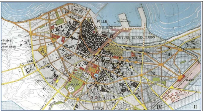
Figure 3.8: Map of Casablanca indicating the main districts in 1950
Source: Cohen, J. and Eleb, M., 1998. Casablanca, Mythes et figures d’une aventure urbaine. Vanves : Editions Hazan.
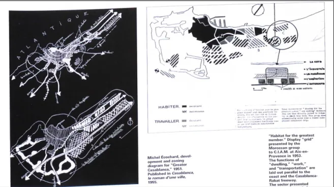
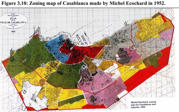
After the first world war, the population of Casablanca was 97,000 people, and the urban perimeter reached in 1921 nearly 2450 hectares resorting to the expropriation of the neighboring agricultural zones. The rural areas experienced difficult times because of the colonization of some of the lands. In this way, the urban perimeter had reached 12835 hectares in 1936 with a population of 257,000 inhabitants. The expansion of the city and the urbanization of more regions has diversified the emergence of three types of housing, villas, economic housing and clandestine and shantytown housing. To organize the urbanization, as the expansion kept increasing, a new urban planning called Ecochar has been made by Michel Ecochar in 1952 (Figure 3.10). It was a linear extension plan, along the coast, linking the port of Casablanca with another one in Mohammedia, and bordered by the creation of the Casablanca-Rabat highway. The architect created a business district near the port, where many new buildings that were for a long time a landmark in the urban landscape of the city have been built. Ecochard's zoning plans, approved in 1952 when the population was 582,000 people, would remain valid in Casablanca until 1984 with around 3,000,000 inhabitants.
(Cohen and Eleb, 1998)
Figure 3.10: Zoning map of Casablanca made by Michel Ecochard in 1952.
The European immigration started with the beginning of the century and lasted until the early 1950s. Almost non-existent in Morocco until 1912, the European population grew very rapidly over the next two decades, reaching 172,500 in 1931 and doubling sixteen years later. (Table 3.1)
Source: Cohen, J. and Eleb, M., 1998. Casablanca, Mythes et figures d’une aventure urbaine. Vanves : Editions Hazan.
Table 3.1: The evolution of the foreign population in Morocco by nationalities between 1926 and 1951
Housing in the colonial period
The architecture of Moroccan community housing has undergone significant changes during the colonial period. Indeed, this period has seen the introduction of apartment buildings that were considered as new forms since a building collecting many houses was unfamiliar to the Moroccan culture. However, the apartment buildings were differentiated depending on the people that it will be destined to. In other words, the buildings constrcuted for the European population differs from the ones built for Moroccans as the protectorate aimed to mark the organization of the Moroccan urban space by spatial separation between the Moroccan population and the European population. While this policy is considered by the French colonizers as a way of preserving some traditions and cultures, it is in fact a social practice that responds to hygienist concerns characterized by feelings of scorn and fear with regard to this qualified population as "dangerous". Thus, this form of urban planning has given rise to new cities reserved for Europeans (Rachik, 1995).
Source: Catin, M. Cuenca, C. and Kamal, A., 2008. L’évolution de la structure et de la primatie urbaines au Maroc. Région et developement, 27, Paris: L’Harmattan
Like all other types of dwellings intended at the time for Europeans, the apartment buildings at the beginning of the protectorate, which was one of the foundations of the European city, enjoyed considerable comfort and luxury. In fact, they consisted of large block-shaped buildings with an interior courtyard. Observers see it as a reminder of some of the great Parisian buildings. However, despite this luxury displayed, apartments whose surface area rarely exceed 50 m2 have only two or three rooms. (Cohen and Eleb, 1998)
In addition, luxurious perimeter blocks appeared in the same period. This type of building is built on very large lands bordered by several streets forming a large island. In general, all the rooms of the apartments are enlightened naturally including the bathrooms which give sight either on the street or on the courtyard. The main rooms retain regular shapes, and the remaining spaces are often used to create storage rooms.
Figure 3.11: Apartment buiding constructed for Europeans in Rue d’agadir, Casablanca in 1928
Source: Cohen, J. and Eleb, M., 1998. Casablanca, Mythes et figures d’une aventure urbaine. Vanves : Editions Hazan.
Figure 3.12: A Moroccan decorative style applied in a European apartment building in Casablanca
Indeed, the relatively parsimonious decor of all the initial buildings follow a production corresponding to the use of the dominant themes at the time, when Art Nouveau and neo-classicism were in competition. Then appear strategies of assimilation of the Moroccan culture by merging the built landscape with the Moroccan decorative style. In some cases, the presence of hybrid configurations can be noted beyond the simple combination of forms of Moroccan origins and European ones to constitute authentic inventions. (Cohen & Eleb, 1998)
Source: Cohen, J. and Eleb, M., 1998. Casablanca, Mythes et figures d’une aventure urbaine. Vanves : Editions Hazan.
3.1.2 Evolution after the independence
After the political independence obtained in 1956, the cities of Morocco started moving their center of gravity so the Ecochard planning wasn’t taken into account anymore since it was a colonial decision. Thereby, the spatial segregation promoted by urbanism colonial has been transformed into social segregation promoted by the standard of living. The Europeans were definitely leaving the neighborhoods they were offered, and the Moroccan urban elite was replacing them in these new types of housing. The Moroccan Jews became more numerous to emigrate and thus to empty the Mellah and the old medina, so shanties inhabitants and rural migrants found the opportunity for piling in the medina. Parallel to these multiple mobility of population, the rural immigration took more and more importance. Admittedly, the Moroccan elite had begun to invest in residential villas after 1956, although it was not a general phenomenon, but it was obvious that a new kind of life appeared in new attitudes (European-style neighborhoods), in the way of moving (cars) and in the design of housing (modern houses). On the other hand, the slum housing was becoming more saturated, and started developing in small districts (Douars), near residential neighborhoods. (NACIRI, 1985)
After the independence, the rural migration continued and the increase in the number of Douars marked the 1950s in terms of urbanization since there wasn’t any new habitations provided for the working-class. In fact, the dimensions of the problem turn out to be some of the major consequences of the colonial development, as it was concentrated in the big cities where there is much more profit especially in Casablanca, unlike the rural world which was neglected and disintegrated in the development. As a result, the new independent country found itself in no way prepared to control the urban growth.
Figure 3.13: The location of the main shantytowns and their population in 1953
In 1965, Casablanca experienced a disorder that included the urban movement, so it was necessary to make a reorientation of the spatial planning for a better harmony between rural and urban planning. In 1972, there was the creation of a Ministry of Housing and City Planning, which means that the Moroccan government started giving more importance to the implementation of a better and more effective housing policy.
Regarding the housing issue, the 1970s was an important period because of the birth and expansion of massive areas since Casablanca became an urban center which the authorities couldn’t predict or control its growth. It is at the end of the 1970s that the public authorities began to measure the extent of Casablanca's urbanization and its socio-political implications. For political power, alongside the new urban action, it has also become imperative to situate Casablanca and its image both nationally and internationally. The end of the 1970s is considered as a period for awareness with the help of the World Bank, as it was conducting socio-economic studies in Morocco regarding the inadequate housing to propose the
restructuring of the main sub-integrated zones. The official concern of the Bank was simple, promoting the standard of living of the population.
In 1981, the Parisian architect Michel Pinseau was called to make a new urban planning for the city. The results of the population census in 1982 showed a decline in the alarming forecasts concerning the population of Casablanca. With 2.3 million inhabitants in 1982, the economic capital of Morocco concentrated 12 percent of the Moroccan population for 50 percent of the country's economic activity. Since 1981, Casablanca was divided administratively into five major prefectures: Ben M'sik-Sidi Othman, Ain Chock-Hay Hassani, Casablanca-Anfa, Ain Sebaa-Hay Mohammadi and Mohammedia Zenata. Starting from 1984, the city is controlled at the urban level by a control and decision center, the Urban Agency of Casablanca. The challenge was ambitious: to create an emulation between the different prefectures for better urban management and at the same time to control urban development as completely as possible. The proposition of Pinseau (1981), the architect who was in charge of the urban planning of Casablanca, was a document presenting the major urban development options valid for a period of twenty years. The most important points of this document were the urban extension towards Mohammedia (rather than towards El Jadida), the improvement of transport, the distribution of the central equipments (universities, hospitals), finally the setting up of a tool of management and control of urban development. (Pinseau, 1984)
As part of the justification report of the planning of Casablanca, the identification of urban problems is quite convincing. The team justified the document first of all by the insufficiency of the urban and road equipments compared to the extension of the urban perimeter which was reflected in lands deficit. The lack of the equipped lands was also reflected in the progression of the density of the urban space. However, this densification mainly benefits the main producers of housing: landowners, land developers and public authorities. The insufficient production of housing and the unsuitability of the financing method for access to housing are also among the observations made in the supporting report. It was envisaged the creation of a Land Agency beside the Urban Agency. In this regard, it should be recalled that
4000 hectares for the period 1982-1990. But the land agency has never been created and its mission have been transmitted to the urban agency. However, in 1990, the Urban Agency could only urbanize 1000 hectares out of the 4000 recommended. Such mismanagement conducted by the people or the organizations in charge caused the increasing of the density of the city and for sure it led to the increasing of the demand of housing compared to the supply. So, Casablanca ended up suffering from the lack of housing while it’s getting more urbanized and developed. (ZYANI, 2013)
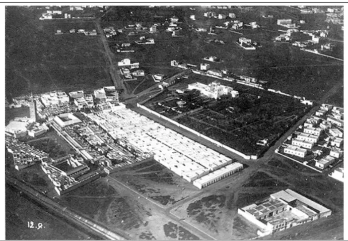
The economic capital experienced a development in different sectors including the technological industries and services thanks to the presence of the most qualified human resources in the country. The agglomeration of Casablanca represents almost 50 percent of the national production which sees the development of financial activities (the stock market), business services and industries such as, the recent creation of the Technopark in 2001 (hosting and support structure for start-ups, small and medium-sized companies, international brands in the field of new technologies) and the Techno pole of Casablanca airport. To better understand the weight of the economic capital of the country, it should be noted that in 1982, Casablanca also accounted for 25 percent of the urban population, 75 percent of foreign trade, 33 percent of the total energy consumed, 50 percent of doctors, 50 percent of the car fleet, 66 percent of bank deposits, 50 percent of the textile industry and 75 percent of the pharmaceutical industry. (Benkiran, 1993)
The diffusion of industrial development was largely done on a limited part of the country, particularly south and north of Casablanca, and especially on the Casablanca-Mohammedia-Rabat-Kenitra axis, a coastal strip of 150 km which today concentrates two fifths of the urban population. The concentration in the urbanization contributes in increasing the density (which was already high), industries, and multiple investments in the coastal strip Kenitra-Casablanca and especially Kenitra-Casablanca which enlarged the gap between this region and the rest of the country and promoted the city to become an urban center not only for Morocco but for the north African countries at the end of the 20th century and the beginning of 21st century.
Figure 3.14: Technopark in the south of Casablanca built in 20
Source: ELASRAWI, S., 2015. Technopark: ses réussites et ses projets. Le360, [online] 21 May 2015, http://fr.le360.ma/economie/technopark-ses-reussites-et-ses-projets-40701 (accessed 09 November 2017)
3.2 THE HOUSING MARKET IN CASABLANCA
Moroccans prefer living in their own property and the trend is strengthening, since 67 percent of urban households own their houses with only 18 percent of them owned their previous home. This means that the majority moved from a rental house to an owned one and consider rental as a temporary solution until they afford buying or building their own house. It is also interesting to note that the ownership of housing is mainly through self-promotion as 45 percent of housing was built by their owners. 18 percent of the houses owners bought their property from an individual, while 15 percent bought it from a private developer. Another fact that was not expected was that bank credit contributes only 14 percent to housing finance. In order to access property, Moroccans rely much more on their own funds, which represent 75 percent of the financing. Another thing that should be noted is that Moroccans do not prefer to move as less than 6 percent of the urban households are planning to change their houses in the next five years, and 81 percent of them are planning to stay in the same city. While 86.5 percent of housing seekers in Morocco wish to acquire a property, only 13.3 percent prefer renting. Adding to it the fact that 67 percent of the households are currently owning their houses, with 45 percent who bought lands and built their houses themselves, it can be concluded that Moroccans tend to buy or build their houses instead living in a rental house, and consider renting as a temporary solution. (MHPV, 2016)
In 2014, the housing stock reached 8.86 million housing units in the 16 regions of Morocco, and 8 of the 16 regions of the country contain 80 percent of the urban dwellings. The region of Casablanca as it represents the economic heart of the country contains nearly 21 percent of the total number of the dwellings.
HOUSING TYPOLOGY
The accommodations in Casablanca can be divided into:
a) Traditional Moroccan house: this type of house is usually widespread in the old medinas. It consists of a central courtyard surrounded by living rooms. The traditional houses are habitations that look blind, and which are divided into two types: Dar or Riad and both of them are houses completely closed from outside and organized around a central patio,
following the model of traditional Arab-Muslim habitat. The Riad is considered as a luxurious Dar as the difference between them is limited to big rooms and a planted courtyard with a fountain in the center in the Riad instead of smaller rooms and an unplanted patio in the Dar. The Arabic word Riad means Garden, and Dar means house and both are based on organizing the rooms in two or three floors without any openings looking outside the house. The rooms are all aligned around the patio and have openings toward it. The houses are mostly hidden behind the walls of the old Medina in the old Moroccan cities. (Fes, Marrakech, Rabat, Casablanca…). The Moroccan traditional houses are sometimes centuries old and are distinguished by the characteristics of their planning, their decorations and the opening that aims to bring freshness and outdoor life inside the house. (Atif, 2011)
Figure 3.16: Ground floor plan of a Dar
Source: Atif, S., (2011). Modèles d’habitats entre persistances et mutations. Thesis for M.A. Lausanne : Faculté de l'environnement naturel, architectural et construit.
b) Modern Moroccan house: construction of an individual block with several levels but used as a single house utilizing the different floors for different functions. (Atif, 2011)
Figure 3.17: Samples of modern Moroccan houses plans
Source: Atif, S., (2011). Modèles d’habitats entre persistances et mutations. Thesis for M.A. Lausanne : Faculté de l'environnement naturel, architectural et construit.
Figure 3.18: Samples of modern Moroccan houses front views
c) Villa: it is the villa in the usual sense of the word, that is to say a unit of housing built in one piece, consisting mostly of not more than two levels and a garden.
d) Apartment: it is an apartment in a building, any building intended for collective living (several households) and containing at least three dwellings.
Source: Atif, S., (2011). Modèles d’habitats entre persistances et mutations. Thesis for M.A. Lausanne : Faculté de l'environnement naturel, architectural et construit.
e) Slums or shanties: this is a construction usually made from recovery materials (wood, zinc, reeds, tinplate...). This type of construction is usually located in peripheral urban areas or slums.
Figure 3.19: Shanties made of tinplate
3.2.1 Housing demand
Moroccans are more looking for buying their homes than renting as 86.5 percent of applicants opt for the acquisition of their houses, against 13.3 percent for rental at the national level.
Source: Atif, S., (2011). Modèles d’habitats entre persistances et mutations. Thesis for M.A. Lausanne : Faculté de l'environnement naturel, architectural et construit.
demand, as it contains 30 percent of the national demand which means 478,300 applicants. (Figure 3.20)
There is a great preference in Casablanca for houses against lands. The housing demand represents 83 percent, and only 17 percent of requests are for lands. 45 percent of applicants opt for apartments, 34 percent for modern Moroccan houses and 4.3 percent for villas. As for the area of the house, houses between 50 and 100 square meters represented 80 percent of the requested housing, while for the demand of lands the area between 80 and 100 square meters was the most requested land surface with 42 percent. (MHPV, 2016)
Figure 3.20: Distribution of demand by region
At the national level, demand is largely focused on purchasing houses that are ready (79 percent), the purchase on plan is, meanwhile, not very popular, it represents around 14 percent of the housing demand. Houses built by large public companies are requested by about 42.7 percent of the house seekers, while it’s 26.8 percent for houses built by private companies, and 16 percent for individuals. (MHPV, 2016)
The desired housing environment is also important for the housing demands. The equipments that were identified as the top priorities for the environment of the house are schools and
Source: Ministry of housing and city planning, 2016, Etude relative à l’enquéte national sur la demande en habitat
health facilities, as education represents 60 percent of the demands priority and health facilities 47 percent. Then the public transportation was identified as a second priority, with 43 percent of priorities of the demands. (MHPV, 2016)
For the other types of equipment, the priorities of the applicants remain identical and are presented according to the same hierarchy:
a) Mosques 35 percent.
b) Administrative and social institutions 28 percent. c) Activity and employment centers 10 percent. d) Sports and entertainment equipment 12 percent. e) Green spaces 13 percent. (MHPV, 2016)
3.2.2 The imbalance of the housing market
The housing market in Morocco in general and in Casablanca in particular is suffering from an imbalance mainly because of the lands reserved for the production of housing or the constraints in the financial level. The land market is experiencing an increase in prices and an infernal speculation mainly due to:
a) The absence of an operational structure responsible for the evaluation and the promotion of the land reserve.
b) The depletion of the State's land reserve in the urban areas.
c) The lack of strategies that focus on the restoration of reserves to support the pressure of urbanization demand.
Faced with this situation, the state is responsible to execute its regulatory role by injecting the necessary land for the equilibrium of the real estate market. It must constitute enough reserve for the production of housing in order to preserve the land from any form of speculation. This land constraint has led to the development of an anarchic urbanization on
In addition to the land problem, the housing market faces two major constraints: the accessibility of households to housing and the weakness of the financial infrastructure. Government initiatives seek to solve these problems by increasing the production of housing destined to the lower class population. However, the roots of these problems (unemployment, rural depopulation and financial incapacity) are still not adequately addressed. This results in the existence of a market with a high potential for improvement in the short term but which remains very worrying in the long term. (OPIC, 2006)
In addition, housing loans represent between 10 percent and 15 percent of loans to the economy; this percentage is around 30 percent in the industrialized countries. Moreover, the institutional financing system contributes barely 20 percent of the financing for the production of housing. In addition, the recent adoption of measures aimed at widening access to credit through the involvement of commercial banks remains insufficient because of the excessive interest rates which increase the burden of repayment on citizens. (Ministry of Spatial Planning, Environment, Urban Planning and Housing, 2007)
The household must have access to decent housing suitable for ownership or rental. This price increase marks the end of one period and the beginning of another characterized by even higher prices which will certainly lead to the aggravation of social disparities. Indeed, the increase in prices should normally lead to a fall in demand, in the absence of increases in household incomes, something that is not currently predictable. The fall in demand will create a slowdown in production, which is now dominated by a private sector. However, production will inevitably spread to cheap economic housing with very small units. Moreover, this trend is already starting to emerge. (Effina, 2011)
3.2.2.1 Housing deficit
Since independence, the expansion of the urbanized perimeter in Casablanca was not only irreversible but also difficult to manage, both in terms of control of its development and to face the size of resources that has to be provided. In order to respond to this problem of urbanization, the State has moved towards the encouragement of a new type of social housing offered for sale in a lower price than the market’s, since it is totally exempted from taxes.
Thus, efforts have been made to promote real estate development in general and to carry out or initiate social housing programs in particular. However, despite these efforts, the current housing situation in Morocco remains poor, especially in terms of quality. This leads to analyze more and to think a little further in order to reach the true roots of the problem. Casablanca, since the period of colonization, undergoes a strong pressure of the demand in housing due mainly to the demographic growth and the rural exodus. Currently in Morocco, the deficit in decent habitat is estimated at one million units. Part of this habitat deficit is also due to the decline in household cohabitation since 1982. (RGPH, 2004)
This phenomenon, which represented an economic and especially social stake, has led to radical changes in the social and spatial organization of the urban fabric. This has resulted, in particular, in the proliferation of non-regulatory housing areas, built without a management plan, lacking all infrastructure and equipment, thus forming large areas of unhealthy housing endangering public safety and health.
3.2.2.2 The factors behind the deficit
The housing market in Morocco has recently experienced a remarkable rise after a long period of stagnation. Nevertheless, this recovery remains insufficient to reduce the large housing deficit. This is mainly due to several factors: The first component of these factors is endogenous, since it is linked to the general economic environment of the country and to the demographic change and its impact on the urban development. The second component, is linked to the process of opening up the national economy to the rest of the world.
The first endogenous factor that can strongly influence the housing market is the imbalance between supply and demand. Indeed, when the demand in the market greatly exceeds the supply, the situation obviously results in an increase in prices. However, in Casablanca, the balance between demand and supply seems far from rational. Indeed, in April 2005, a survey of the MENA housing sector (Middle East and North Africa) concluded that many countries in the region suffer from problems of accessibility rather than inadequate housing. The same report found that the ratio of "Housing Price / Income" in Morocco (9.2) is the highest in the