Kinet Höyük (Classical Issos): A Harbor Town in Southeast
Cilicia during the Persian and Hellenistic Periods
Charles Gates
Journal of Eastern Mediterranean Archaeology and Heritage Studies, Volume
3, Number 2, 2015, pp. 81-104 (Article)
Published by Penn State University Press
For additional information about this article
Access provided by Bilkent Universitesi (29 Jan 2019 08:00 GMT) https://muse.jhu.edu/article/581634
journal of eastern mediterranean archaeology and heritage studies, vol. 3, no. 2, 2015
Copyright © 2015 The Pennsylvania State University, University Park, PA
Excavations conducted from 1992–2012 at Kinet Höyük, a coastal site in southeast Cilicia, have revealed impor-tant remains of the Persian and Hellenistic periods. The site has long been identified as Classical Issos, near where Alexander the Great and Darius III fought in 333 BC. The Persian settlement consists of three architec-tural levels, and the Hellenistic town of two, altogether spanning the mid-sixth to the mid-first centuries BC. The last of the ancient settlements was founded in ca. 175 BC, perhaps as part of the revitalization of Cilician towns under Antiochus IV. Persian and Hellenistic find-ings come mostly from the mound proper, but soundfind-ings to the west, north, and east of the mound have demon-strated the existence of a lower town.
key words: Kinet Höyük, Cilicia, Issos, Issus, Battle of Issos/Battle of Issus, Iskenderun Bay, Persian Anatolia, Hellenistic Anatolia, Alexander the Great
abstract Kinet Höyük, an ancient harbor town located on the Mediterranean coast in the southeast corner of Cilicia,
is notable for its long occupation (Fig. 1). According to excavations conducted from 1992–2012 by Bilkent University under the direction of Marie-Henriette Gates, habitation began in the Late Neolithic period, as attested by the unstratified finds of Halaf potsherds. The earliest levels reached through excavation are of the Early Bronze II period (ca. 2800–2600 BC); stratified architectural levels continue almost without interrup-tion until the mid-first century BC. After a lengthy abandonment, the site—by this time an artificial mound prominent on the coastal plain (Fig. 2)—was fortified during the later Middle Ages (late twelfth– fourteenth centuries): a hilltop stronghold located on the cusp between the Armenian Kingdom of Lesser Cilicia and Crusader states, with Arab states not far inland (Redford et al. 2001).
This article focuses on one segment of its long his-tory, the final 500 years of ancient settlement, during the Persian and Hellenistic periods.1 This half millennium
is not well known in Cilicia, because excavations in the region have habitually focused on earlier or later peri-ods (C. Gates 2005). To cite one major example, Tarsus, the regional center in Persian times according to ancient written sources, is best known for its Bronze Age remains, thanks to the excavations at Tarsus-Gözlükule carried out by Hetty Goldman from 1935–1949 (before
Kinet HöyüK (ClassiCal issos)
a Harbor town in southeast Cilicia during
the Persian and Hellenistic Periods
82 | Kinet HöyüK (Cl assiCal issos)
and after World War II) and resumed by Aslı Özyar in 2001 (Özyar 2005). Persian Tarsus, still undiscovered, may lie under meters of silt. Kinet Höyük, however, has yielded evidence for continuous occupation during these centuries. The final report, now in preparation by myself together with several collaborators, should make a sig-nificant contribution to our knowledge of Cilicia and its vicinity in this period.
As a harbor town, Kinet Höyük offers an additional contribution to our understanding of ancient Cilicia (M.-H. Gates 1999). Cilicia is traditionally divided into two regions: Rough (Tracheia), the mountainous west (Hoff and Townsend 2013); and Smooth (Pedias), the largely flat alluvial plain in the east. Despite its long Mediterranean coastline, little is known of its harbor towns, especially in Smooth Cilicia.2 Silting from Smooth
Cilicia’s rivers—notably the Cydnos (modern Berdan),
the Saros (modern Seyhan), and the Pyramos (modern Ceyhan)—has altered the coastline, obscuring ancient habitation. Although Kinet Höyük lies just in from the coast and today’s coastline is straight, geomorphological research conducted during the excavations indicates a constantly changing topography for its harbors, the riv-ers that flowed by it, and the coastline.
Harbor towns were also located inland, along the riv-ers. Tarsus on the Cydnos is a prime example, but others include Misis (ancient Mopsuestia) and Sirkeli Höyük, both situated on the Pyramos and currently under inves-tigation (for Sirkeli Höyük, see Kreutz 2011). These rivers were important arteries for communication, trade, and other contacts by means of small ships and rafts. This feature is not easy to understand today when asphalt roads fulfill this function, and the rivers have instead become barriers to be bridged and crossed (Oruç 2013).
FiG. 1
a map of Cilicia with circles representing modern sites and triangles ancient ones. (Courtesy of the Kinet Höyük Project.)
Journal oF eastern Mediterranean arCHaeoloGy and HeritaGe studies | 83
The name Kinet is modern and of uncertain origin. It may be a corruption of the medieval name Ḥiṣn al-Tinat (“Castle of Figs”), an early Islamic settlement located 1 km to the north or perhaps Kinet itself (Eger 2010). The site has otherwise been identified with Classical Issos, the city near which Alexander the Great defeated the Persian king, Darius III, in 333 BC (Hellenkemper 1984). Despite a lack of epigraphic confirmation from the site itself, the location corresponds with specifications in ancient texts (such as Xen. An. 1.4.1–4), and the ample stratified architectural remains indicate the town was important in the Persian and Hellenistic periods. No other site in the vicinity has yet given comparable evidence for occupa-tion in these centuries.
Earlier names of Issos may have been Zise and Izziya in the Late Bronze Age (Forlanini 2001: 553–57; Archi and Venturi 2012: 25 n. 13, 34–38, 45–47) and Sissu in the
Iron Age (Bing [1985] 1993). These identifications are of interest because these places have historical events associated with them. Despite the similarity of the names, the identifications have met with varying degrees of acceptance for philological and geographical reasons (M.-H. Gates 2013a: 232–33; Archi and Venturi 2013: 219–20). The most controversial may be the last. Sissu is generally linked with ancient Sision (a Greek name), later called Sis, the capital of the medieval Kingdom of Lesser Armenia (1186–1375), and today Kozan, a town in the foothills of the Taurus Mountains—quite distant from the seacoast (Casabonne 2004: 186–87; Radner 2009–2011). However, a coastal location for a town so important to the Phoenicians, Cilicians, and Assyrians would make more sense. Perhaps both settlements, inland and coastal, had similar names; this possibility cannot be ruled out.3
FiG. 2
an aerial view of Kinet Höyük (right center) and the Mediterranean sea in 2010. (Photo by airstudyo. Courtesy of the Kinet Höyük Project.)
84 | Kinet HöyüK (Cl assiCal issos)
The Persian Period
Cilicia fell under Achaemenid Persian control from the mid-sixth century BC until the campaign of Alexander the Great in 333 BC. The historical reconstruction is fragmen-tary; ancient texts do not give many details. Archaeology contributes to the picture, as do numismatics (Casabonne 2004). The Persian takeover seems to have been peace-ful. The region was ruled from the early sixth century BC, before the Persians arrived, until ca. 400 BC by a dynasty of local potentates called Syennesis by Greek historians, a word used as a title and perhaps also as a name. Tarsus was their base (Casabonne 2004: 165–67, 181–85). In 401 BC, the Syennesis supported the revolt of Cyrus the Younger against his brother, the Persian king Artaxerxes II. Because Cyrus crossed Cilicia on his march eastward from Sardis, his satrapal base in western Anatolia, to the empire’s heartland, the Syennesis thought it politic to support him (Xen. An. 1.2.12, 21–27). But Cyrus was killed at the Battle of Cunaxa, north of Babylon. With the failure of the rebel-lion, the Syennesis must have been in a difficult position. The title is not heard of again; Persians, it seems, took over the administration of the province from local elites.
In addition to providing a large annual tribute to the Persian state—500 talents and 360 white horses, at least during the reign of Darius I (522–486 BC; see Hdt. 3.90)—Cilicia served as a mustering point for Persian military and naval expeditions against uprisings in their eastern Mediterranean territories (Wallinga 1991). Numismatic evidence is relevant here (Dusinberre 2013: 72–76). During the Persian period, Cilicia saw coinage issued variously by the central state (gold darics), by indi-vidual cities (notably Tarsus, but also including Issos in the fourth century BC), and also by the satraps or gen-erals who needed to finance military campaigns in the fourth century BC: Tiribazos, Pharnabazos, Tarkumuwa, and Mazaios (Le Rider 1997; Casabonne 2004: passim, esp. 174–81, 188–223).
Kinet Höyük offers significant evidence for this period, but of a sort quite different from texts or coins. Architectural remains, ceramics, and random small finds reflect the daily life of a harbor town. For the most part,
this seems to have been a local center. Objects found in satrapal capitals and connected with Persian prestige are absent or rare, such as Achaemenid ceramics, seals, and pictorial art (as discussed in Dusinberre 2013).
The Persian period at Kinet Höyük is divided into three architectural levels: Periods 5, 4, and 3B. The first, Period 5, is dated from the mid/late sixth century to ca. 450 BC. This is a shadowy time that we wish we knew more about because it represents the first century of Persian occupation in Cilicia. Until the excavations at Kinet Höyük, the best archaeological evidence for the Persian period in the region came from Al Mina, a low mound located some 100 km south of Kinet Höyük on the Mediterranean coast near the mouth of the Orontes River. Al Mina was excavated by C. Leonard Woolley in 1936–1937 (Woolley 1938a–b). He hoped to find the Middle and Late Bronze Age harbor town that served the inland city of Alalakh (Tell Atchana), but instead the finds indicated occupation from the eighth through fourth centuries BC, followed by the late Roman–early Byzantine periods and the Middle Ages (ninth through thirteenth centuries). Level 4 represented the earli-est Persian settlement at Al Mina. It began in 520 BC, according to Woolley, some 30 years after the end of the preceding Level 5. Subsequent research has suggested a longer gap (Robertson 1940: 21; Taylor 1959: 92; Perreault 1986: 146). At stake is not only when Persian rule began, but also how, as well as the site’s early character. For this reason, any evidence provided by Kinet Höyük would be particularly welcome.
The Kinet finds, however, have not provided clear answers. The preceding Period 6, dated to the late seventh century into the sixth century BC, had yielded good archi-tectural plans of houses and other small buildings and ceramics of a standard East Greek type, common through-out the eastern Aegean, the eastern Mediterranean, and the Black Sea. At Kinet Höyük, excavations on the west side of the mound in Area E/H (Fig. 3) revealed a Period 5 deposit 50 cm thick, but with only a few fragmentary wall foundations and a relatively small amount of sherds— remains indicating an outdoor area of no particular func-tion (C. Gates 1999: 324). These finds do not give a precise
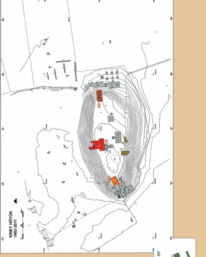
Fi G . 3 a topographic plan of K inet H öyük with ex cavation ar
eas discussed indicated in ligh
t orange (
e/H), dark orange (
ad ), r ed ( G), br own ( u and P), and gr een (BP). (C ourtesy of the K inet H öyük P roject.)
86 | Kinet HöyüK (Cl assiCal issos)
date for the beginning of Period 5. Whether or not there was a gap in occupation at Kinet Höyük as at Al Mina is a question that awaits further study.
Of much greater interest was evidence for a large-scale building discovered in 2007 on the south edge of the site (Area U). In a small excavation exposure (6 by 11 m = 66 m2), massive foundations appeared (1.1–1.4 m
thick by 2 m deep; M.-H. Gates 2009: 359–60, 368, fig. 14), containing two small rooms, probably casemates (Fig. 4). Because the superstructure was not preserved, its nature can only be guessed: a platform or terrace, perhaps a tower, or simply a massive wall? The thickness of the walls does suggest the building served an administrative
or military function (Fig. 5). Because the foundations had no associated finds, a date sometime in Period 5 has been assigned because of their clear stratigraphic position between Period 6 remains (below) and Period 4 (above).
The materials used in the foundations give this build-ing its particular interest. Kinet Höyük is located in a particularly rainy corner of the Mediterranean, where the Amanos Mountains, just inland, have a slightly concave profile that captures the moisture-bearing winds com-ing from the west across the sea. As typical throughout the Near East, walls were usually made of unbaked, sun-dried mud bricks, a cheap yet effective building material, but one that requires protection from water. To prevent ground water from penetrating the mud-brick walls, wall foundations at Kinet Höyük were almost always made of medium-sized naturally shaped river stones and placed above ground. In contrast, the foundations of the Period 5 building were made of gravel and cut pieces of local conglomerate poured into sunken trenches. This distinctive practice is attested in no other building at Kinet Höyük or elsewhere in Cilicia. The only paral-lel I know of comes from Susa, the Achaemenid Persian capital, at the early-fourth-century BC Chaour Palace4
(Boucharlat 2010: 385–92). Despite the difference in dat-ing between these two builddat-ings, the connection with the Persian heartland in this aspect of construction practice is an important cultural link. Could the building have been commissioned by the imperial administration as a hilltop outpost or fortress in this location, commanding access both to the sea and to the nearby Amanos Mountains, rich in timber and minerals?5
Persian Kinet Höyük comes into better focus in the mid-fifth century BC, with architectural Period 4 (ca. 450–400 BC). On the west side of the mound in Area E/H, this period is represented by two architectural phases, which are variants of a similar plan: a series of small rooms sharing walls, running east–west. Remains of this period were not found on the north or east sides of mound. In Area U, however, wall foundations of typical naturally shaped river stones were discov-ered, forming a room with an entrance on the south (M.-H. Gates 2009: 359). This room as well as rooms in Area E/H yielded, among other finds, fragments of Attic
FiG. 4
a plan of the Period 5 building in area u. (Courtesy of the Kinet Höyük Project.)
Journal oF eastern Mediterranean arCHaeoloGy and HeritaGe studies | 87
black-glazed ceramics (Fig. 6) and several amphorae of east and southeast Aegean, Cypriot, and Levantine types, attesting to the commercial links with other cit-ies in the eastern Mediterranean. Also uncovered in each area was a low clay platform, partially burnt, with circular holes inside measuring 8–32 cm in diameter (Fig. 7); the holes seem intended as holders for ampho-rae—a feature unique to this period (C. Gates 1999: 324–25). The purpose of the rooms is uncertain, but the discovery of the amphorae holders and many ampho-rae fragments in two separate excavation areas indi-cates storage or commercial activities in this district of the town.
The most striking evidence for the Persian period occurs in Period 3B (ca. 400–330 BC). At the beginning of the fourth century, the hilltop town was enclosed with a new fortification wall. The reasons for its con-struction are uncertain. Perhaps this building activ-ity is connected with some of the events noted above: the rebellion of Cyrus the Younger in 401 BC, the unrest in the eastern Mediterranean in the decades that followed, and the role of Cilicia as a base for the Persian military.
Traces of the impressive stone foundations were recovered in particular on the north and west sides in Areas G and E/H; they are also attested on the south
FiG. 5
FiG. 7
an amphora holder from Period 4 in area u. (Courtesy of the Kinet Höyük Project.)
FiG. 6
Journal oF eastern Mediterranean arCHaeoloGy and HeritaGe studies | 89
as well, in Areas P and U (for Area P, see M.-H. Gates 2001: 210). An entrance was discovered on the west in Area E/H (C. Gates 1999: 326–27). This monumental entrance, measuring 5 m wide, had a threshold of lime-stone blocks of varying sizes, smoothly worked on the visible surface but left rough on the other sides (Fig. 8). At either end stood a large upright limestone block (ca. 0.55 m high), each with traces of plaster, unpainted on the north block but with the remains of red on the west face and yellow on the north face of the southern
block (Fig. 9). Adjacent to the entrance was the stone foundation of a tower (2.4 by 3.1 m), preserved to a height of 1.05 m. Inside the broad threshold lay a small plaza with a prepared gravel surface.
The citadel enclosure wall was best observed on the north in Area G, where a section 15.30 m long was exposed (M.-H. Gates 2000: 198; 2001: 208–10). Built of unshaped river stones set without mortar, the wall was 1.70 m thick and preserved to a height of 2.30 m (Fig. 10). Buttresses (1.0 by 1.1 m) are projected at close if inconsistent
FiG. 8
90 | Kinet HöyüK (Cl assiCal issos)
FiG. 10
the Period 3B circuit wall (on the left) and the adjacent building in area G, from the west. (Courtesy of the Kinet Höyük Project.)
FiG. 9
the west entry area of the Period 3B circuit wall in area e/H, from the east. Wall 58, a stone foundation set into a sunken trench, is a later insertion. (Courtesy of the Kinet Höyük Project.)
FiG. 11
the internal buttresses of the Period 3B circuit wall in area G. (Courtesy of the Kinet Höyük Project.)
intervals (1.85 m, 1.85 m, and 3.22 m) along the inner wall face. Their masonry included large limestone blocks set in the projecting corners and, infrequently, basalt blocks from a volcanic region ca. 20 km to the north (Fig. 11). The superstructure would have been made of sun-dried mud bricks, but nothing of this has remained. The forti-fication wall served for over 200 years, continuing from the fourth century into the second century BC. By Late Hellenistic Period 2, it was no longer in use.
Excavations in Area G, the north side of the mound, have revealed that a regularly planned building was con-structed against the fortification, extending south, with several rows of rectilinear rooms placed on terraces of slightly different levels (Fig. 12). Here, mud-brick super-structures survived. The regularity of the plan suggests a military function such as barracks with storage facili-ties and rooms with circular hearths, but the finds do not give a conclusive answer (M.-H. Gates 2003: 285–86;
FiG. 12
Journal oF eastern Mediterranean arCHaeoloGy and HeritaGe studies | 93
2007: 692–93). This complex had a long life, from the later Persian period (Period 3B) into the early Hellenistic period (Period 3A).
The east side of the mound (Areas A–D) has not yielded remains of the fortification wall, in contrast with the south, west, and north. However, thick walls of a massive building appeared in the early excavation sea-sons (Fig. 13). Unlike the huge building with gravel foun-dations from Period 5, this building was constructed in the manner typical at Kinet Höyük with foundations of naturally shaped river stones. In addition to the stone foundations, several courses of brick superstructure were preserved as was a well-defined door with a pivot
stone (C. Gates 1999: 325–26). This must have been an imposing military or administrative building. If built at the edge of the site, its large walls could have also served for defense. Its precise date is uncertain; the surviving basement rooms were largely empty of finds, but its stratigraphic placement between Kinet Periods 6 (below) and the Hellenistic 3A (above) place it within the Achaemenid era. Because the size of bricks used in this wall (38 by 38 by 10 cm) correspond with those of the Period 3B building adjacent to the fortifica-tion wall on the north side of the mound, the building could well have been constructed in the fourth century BC. Similarities with a fourth-century BC building at
FiG. 13
94 | Kinet HöyüK (Cl assiCal issos)
Hacınebi (modern Birecik) on the Euphrates also sup-port this date (McMahon 1996). Like the fortification wall itself, this huge building may have been added at Kinet in response to the turbulent conditions of the fourth century BC.
The harbor installations on the south side of the city mound, in the area where a river once flowed, were closed to investigation after gas storage tanks were constructed there in 1991–1992. However, in September 2011, circumstances allowed soundings halfway between the mound and the current coastline (500 m distant) on heretofore inaccessible property belonging to British Petroleum (Fig. 14). The area sam-pled measured 1.5 ha. Its surface lies at 5.36 m above sea level and the water table at 2.5 m above sea level. The
results were unexpected (M.-H. Gates 2013b: 96–97). Below 2 m of sterile silt, stone wall foundations were uncovered from the three architectural levels identi-fied on the mound (Periods 5/4, 3, and a thinly repre-sented 2) (Fig. 15). Abundant ceramics indicate a date as early as the fifth century BC. If this chronology is con-firmed by detailed study, we have here evidence that the coastline had advanced considerably west of the mound by the mid-Persian period. These walls must represent remains of the lower town and harbor facilities of that time; soundings carried out in 1999–2002 on privately owned farm fields to the northwest, north, northeast, and east of the mound already indicated that the lower town of the Persian and/or Hellenistic periods extended in these directions. The citadel and administrative
FiG. 14
Journal oF eastern Mediterranean arCHaeoloGy and HeritaGe studies | 95
buildings would have been on the top of the mound. With this glimpse of the ancient harbor, we can appreci-ate Xenophon’s description of Issos as large and prosper-ous, with a harbor or anchorage big enough to receive the good-sized fleet of 60 ships assembled by Cyrus the Younger (An. 1.4.1–3).6
Alexander the Great, Darius III, and the Battle
of Issos
Such is the city of Issos as Alexander the Great must have seen it in 333 BC. His campaign in the region, lead-ing to the Battle of Issos, is described in detail by Arrian
(Anab. 2.4–12).7 Alexander and his troops had entered
Cilicia that summer, first settling in Tarsus, which was abandoned by the Persians, later moving eastward to Mallos (Fig. 16). Hearing that Darius III and his army were camped at Sochoi, located on the plain east of the Amanos Mountains,8 Alexander sought a militarily
advantageous position. He assumed Darius would cross the mountains through the Syrian Gates (today’s Belen Pass between İskenderun and Antakya) and so led his soldiers to the southeast, leaving his invalid soldiers at Issos; then crossing the Jonah Pass (also known as the Pillar of Jonah), a crest south of modern Payas that runs perpendicular from the Amanos Mountains down to the Mediterranean; and setting up camp near the city of Myriandros (south of modern İskenderun),9 at
the foot of the Syrian Gates.
Darius, impatient, moved his army west to the inevi-table conflict. He crossed the Amanos Mountains not by the Syrian Gates, but by the Amanic Gates (today’s Bahçe Pass), well to the north, and headed south, knowing that Alexander and his army were squeezed into the narrow coastal plain. En route, the Persians stopped at Issos and tortured and killed the invalid soldiers left there by Alexander.
The confrontation took place in November alongside the Pinaros River; the Persians deployed on the north side, the Macedonians on the south. Outflanking the Persians to the right, Alexander’s cavalry caused a break in the central ranks of the Persians—the key to vic-tory. The Persians were routed and Darius III fled, leaving behind his mother, wife, and daughters.
The exact location of the battlefield is uncertain. The controversy centers on the identification of the Pinaros River. The coastal plain from the area of Kinet Höyük south to the Jonah Pass contains four rivers—now essentially seasonal—that flow down from the Amanos Mountains to the Mediterranean: the Deli, Özerli, Kuru, and Payas (their modern Turkish names). Which is the ancient Pinaros? The problem has been compounded by the evolving topography of the region, with its chang-ing coastline and shiftchang-ing river beds. The likeliest can-didate is today’s Payas River. Although not universally
FiG. 15
sounding no. 3 on the British Petroleum lot, from the southwest. (Courtesy of the Kinet Höyük Project.)
96 | Kinet HöyüK (Cl assiCal issos)
accepted, this identification has been supported nota-bly by N. G. L. Hammond, a specialist on Alexander and Macedonia, based on two visits he made to the region in 1941 and 1976 (1994: 95–111), and more recently by geomorphologist Sancar Ozaner and archaeologist Ayşe Çalık (Ozaner and Çalık 1995). Today the presumed
battlefield lies in an ugly industrialized area, just inland from the huge Isdemir iron and steel factory that belches out multicolored smoke and alongside numerous com-panies specializing in recycling scrap metal, with the mountains rising up just behind (Fig. 17). No sign com-memorates the great battle. The place is utterly forlorn.
FiG. 16
a map of Cilicia in 333 BC with alexander and darius iii’s movements before the Battle of issos. rivers: (a) Cydnos; (b) saros; (c) Pyramos; and (d) Payas. Passes: (1) Cilician Gates; (2) amanic Gates/Bahçe Pass; (3) Jonah Pass; and (4) syrian Gates/Belen Pass. alexander’s march from Mallos to Myriandros is shown in green. darius’s march from sochoi to the battlefield near Payas is indicated in yellow (after Mensch 2010: 69, Map 2.7). (Courtesy of the Kinet Höyük Project.)
Journal oF eastern Mediterranean arCHaeoloGy and HeritaGe studies | 97
The Hellenistic Period
After Alexander’s victory, Cilicia passed into the hands of Hellenistic kings. The Ptolemies (or Lagids) took early control, particularly in Rough Cilicia, but soon fought over the region with the Seleucids who ultimately prevailed (Cohen 1995: 49–52; Tobin 2004: 4–5; Tempesta 2013: 27–28). Urban patterns were changing. South of Kinet Höyük, Alexander founded Alexandria ad Issum (modern İskenderun) (Cohen 2006: 73–76; Lehmann, Killebrew, and Gates 2008: 171–76). Antioch, over the Belen Pass, and its Mediterranean seaport at Seleucia Pieria, north of the mouth of the Orontes River, were founded in ca. 300 BC by Seleucus I Nicator (Cohen 2006: 80–93, 126–35). Antioch would become one of the major cities of the Seleucid king-dom. Not far away and still on the main route to Cilicia, Kinet Höyük surely benefited from its proximity to the capital. Objects from Period 3A discovered in deposits
on all sides of the mound indicate the city maintained a cosmopolitan character for much of the Hellenistic period: amphorae (Figs. 18–19) molded bowls and lamps decorated with lion heads (Figs. 20–21), terracotta figurines, and a small Phoenician glass pendant depicting a man’s head.
As noted, the excavations at Kinet Höyük show that the fortification wall and attached structures built in the early fourth century BC continued to be used well into the Hellenistic period (Period 3A). Modifications took place during this time, as one might expect. Eventually, at some point in the early second century, the terraced complex in the north (Area G) was abandoned and filled in with mud bricks; finds of animal bones indicate the space was used as a garbage dump. The area was later damaged by numerous medieval pits.
The final period of ancient habitation at Kinet is later Hellenistic Period 2, attested in the west and south, but especially in the north, in Area G (C. Gates 1999: 327–29;
FiG. 17
the likely battlefield of the Battle of issos, near Payas, from the east, looking toward the isdemir iron and steel factory in July 2011. (Photo by C. Gates.)
98 | Kinet HöyüK (Cl assiCal issos)
M.-H. Gates 2003: 287; 2005: 166–67; 2007: 692–93). The city was refounded on a new plan in ca. 175 BC and reoriented north–south, as opposed to the previous north– northwest by south–southeast. Excavations in Area G revealed two architectural phases within Period 2, with ceramics pro-viding the dating. The formal refounding suggests a pre-cise occurrence with historical associations. Antiochus IV Epiphanes (ruled 175–164 BC), “the most fascinating and most controversial of all Seleucid kings” (Meyer 2001), pur-sued a policy of refounding cities in Cilicia, giving some of them names of Seleucid royalty (Cohen 1995: 355–72; De Giorgi 2011: 132–33). Minting their own municipal coins was a new privilege granted to six cities in Smooth Cilicia, including Tarsus, which already had a royal mint, and to 16 other cities in Syria, Upper Mesopotamia, and Phoenicia. City names and coin types served to demonstrate loyalty to Seleucid power, while the permission to mint was a way for the state to recognize and value the separate identity of each city, thereby securing their support (Meyer 2001).
Although Kinet Höyük/Issos did not mint coins at this time, the new town plan may be another manifestation of this project of recasting relations between cities and the king. The political context after the death of Antiochus IV would seem less propitious for such a refounding; with turbulence in the dynastic succession, Seleucid control in Cilicia weakened (Tobin 2004: 5).
The Period 2 town was smaller than its predecessor, at least on top of the mound, limited to the area just inside the Period 3 citadel of ca. 400 BC. As soundings attest, a lower town continued to exist, but its extent is unknown. Changes in material culture reflect Late Hellenistic pref-erences. Terracotta roof tiles were now used for the first time at Kinet (Figs. 22–23). Late Hellenistic Eastern Sigillata A pottery replaced the “Dribble Ware” prevalent in Early Hellenistic times (M.-H. Gates 2005: 166–67). Finds, such as terracotta figurines, molded lamps, and coins (appearing for the first time), indicate a prosperous town (Fig. 24).
FiG. 18
FiG. 19
an amphora with stamped handles from Period 3a in area u, dated to ca. 200 BC. (Courtesy of the Kinet Höyük Project.)
FiG. 20
a black-glazed imitation lamp from Period 3a in area G, dated to ca. 325–275 BC (KnH-1411; antakya [Hatay] Museum). (Courtesy of the Kinet Höyük Project.)
FiG. 21
a red-glazed three-spouted lamp from late Period 3a in area G, dated to ca. 200 BC (KnH-1448; antakya [Hatay] Museum). (Courtesy of the Kinet Höyük Project.)
FiG. 22
a house with roof tile collapse from Period 2 in area G, from the southwest. (Courtesy of the Kinet Höyük Project.)
FiG. 23
102 | Kinet HöyüK (Cl assiCal issos)
Conclusion
By the time the town was abandoned, ca. 50 BC, its harbors must have filled with silt eroded from the Amanos Mountains—damaging for maritime activity—and the river that flowed by the city (today’s Deli) had changed course, moving to the south. The area may well have become swampy and malarial. In addition, a destructive earthquake seems to have occurred, indicated by roof tiles found neatly collapsed and tilted against the base of several walls. A successor settlement, still called Issos, may have sprung up 1 km to the south of the mound. Surface survey
has revealed potsherds of the Roman period; nearby is a partially preserved Roman bridge, dated to the third century AD (M.-H. Gates 2007: 694). This location may well be the Issos described by Strabo, writing in the Augustan period, as a small town with an anchorage (14.5.19).
In any case, regional settlement and economic patterns were changing. By the time the settlement on the mound was abandoned, Cilicia had become Roman, either directly ruled or under Roman tutelage. During the Roman period, the major town of the region was Epiphaneia, 30 km to the north, with its own harbor at Küçük Burnaz (Tobin 2004). Kinet Höyük would remain abandoned for over 1,000 years.
FiG. 24
a bronze coin of seleucid king, demetrios i, from area K3, issued between 162–156 BC. on the obverse, a horse’s head, turned left. on the reverse, an elephant head, turned right, with [B]a∑i
∧
e[Ω∑] written above and [ΔH]MHtri[oy] written below (KnH-581; antakya [Hatay] Museum). (Courtesy of the Kinet Höyük Project.)charles gates is a senior lecturer in the Department of Archaeology, Bilkent University, Ankara, Turkey, and a member of the Kinet Höyük project since 1993. His research and teaching interests center on Cilicia and Cyprus in the first millennium BC, the Aegean Bronze Age, and Byzantine art and architecture. (Faculty of Humanities and Letters, Department of Archaeology, Bilkent University, 06800 Bilkent, Ankara, Turkey; [email protected])
Journal oF eastern Mediterranean arCHaeoloGy and HeritaGe studies | 103
notes
Many thanks to Marie-Henriette Gates for the illustrations. 1. For shorter treatments of Kinet Höyük in the Persian and
Hellenistic periods, see C. Gates 1999; 2012; 2013; and 2014. 2. A survey at coastal Karataş (ancient Magarsos, the port
of Mallos) has documented a Hellenistic fortification wall (Rosenbauer and Sayar 2011). Further west, excavations have revealed traces of the contemporary harbor towns at Soli at the western edge of Smooth Cilicia and at Nagidos and Kelenderis in Rough Cilicia.
3. Pers. communication, Selim Ferruh Adalı.
4. Thanks to Amanda Dusting for pointing out the parallel at Susa and to Rémy Boucharlat for providing details. 5. On geography and natural resources, see Özbayoğlu 2003;
and Casabonne 2004: 30–44.
6. The Spartans contributed 35 ships; the remaining 25 ships belonged to Cyrus.
7. Arrian’s account of the battle is the fullest by an ancient writer that survives today. Although he lived in the second century AD, long after the events described, he based his work on now-lost eyewitness reports, notably of Ptolemy. For an introduction to Arrian’s work, including comments on the sources he consulted, see Paul Cartledge in Mensch 2010: xiii–xxviii.
8. The site of Sochoi has not yet been identified. Arrian says it is in Assyria, a two-day march from the Syrian Gates (Anab. 2.6.1).
9. Although Myriandros was tentatively located at the site of Büyükdere/Pınar Tepe in a survey of 2006 (Lehmann, Killebrew and Gates 2008: 172–73, 183), more recent survey work (as yet unpublished) suggests the höyük at Gülcihan (ca. 10 km north of Arsuz) is a better candidate (pers. communication, Gunnar Lehmann, with reference to obser-vations made by G. Marmier [1884: 43–47]).
references
Archi, A., and F. Venturi. 2012. Hittites at Tell Afis (Syria).
Orientalia 81:1–55.
———. 2013. Tell Afis in the Thirteenth Century B.C.E. under the Rule of the Hittites. Near Eastern Archaeology 76:214–22.
Bing, J. [1985] 1993. Sissu/Issus, and Phoenicians in Cilicia.
American Journal of Ancient History 10:97–123.
Boucharlat, R. 2010. Autres travaux de Darius et successeurs. In
Le palais de Darius à Suse: Une résidence royale sur la route de Persépolis à Babylone, ed. J. Perrot, 374–419. Paris: Presses de
l’université Paris-Sorbonne.
Casabonne, O. 2004. La Cilicie à l’époque achéménide. Persika 3. Paris: Boccard.
Cohen, G. M. 1995. The Hellenistic Settlements in Europe, the Islands,
and Asia Minor. Hellenistic Culture and Society 17. Berkeley:
University of California Press.
———. 2006. The Hellenistic Settlements in Syria, the Red Sea
Basin, and North Africa. Joan Palevsky Imprint in Classical
Literature; Hellenistic Culture and Society 46. Berkeley: University of California Press.
De Giorgi, A. U. 2011. Hellenistic Founders, Roman Builders: Anazarbos in Cilicia. In Hellenismus in der Kilikia Pedias, ed. A. Hoffmann, R. Posamentir, and M. H. Sayar, 121–38. Byzas 14. Istanbul: Ege Yayınları.
Dusinberre, E. R. M. 2013. Empire, Authority, and Autonomy in
Achaemenid Anatolia. New York: Cambridge University Press.
Eger, A. 2010. Ḥiṣn al-Tīnāt on the Islamic-Byzantine Frontier: Synthesis and the 2005–2008 Survey and Excavation on the Cilician Plain (Turkey). Bulletin of the American Schools of
Oriental Research 357:49–76.
Forlanini, M. 2001. Quelques notes sur la géographie historique de la Cilicie. In La Cilicie: Espaces et pouvoirs locaux (2e millénaire
av. J.-C.–4e siècle ap. J.-C.); Actes de la table ronde internatio-nale d’Istanbul, 2–5 novembre 1999, ed. É. Jean, A. M. Dinçol,
and S. Durugönül, 553–63. Varia Anatolica 13. Istanbul: Institut français d’études anatoliennes; Paris: Boccard. Gates, C. 1999. Kinet Höyük 1992–1997: The Achaemenid Persian
and Hellenistic Periods. Olba 2:323–32.
———. 2005. The Place of the Achaemenid Persian Period in Archaeological Research in Cilicia and Hatay (Turkey). In
L’archéologie de l’empire achéménide: Nouvelles recherches; Actes du colloque organisé au Collège de France par le “Réseau interna-tional d’études et de recherches achéménides,” GDR 2538 CNRS, 21–22 novembre 2003, ed. P. Briant and R. Boucharlat, 49–69.
Persika 6. Paris: Boccard.
———. 2012. İssos—Şehir ve Savaş. [Issos—The City and the Battle.] Aktüel Arkeoloji Dergisi 5 (Ocak-Şubat):132–39. ———. 2013. Issos: The City and the Battle. Actual Archaeology
Magazine 5 (Spring):88–97.
———. 2014. Kinet Höyüğün Akamenid Pers ve Helenistik Dönemleri: 1998–2012 Yılları Kazı Sonuçları. [The
Achaemenid Persian and Hellenistic Periods at Kinet Höyük: Results from the Excavations of 1998–2012.] In Proceedings
of the International Symposium on the Archaeology of Hatay and Its Vicinity through the Ages, 21–24 May 2013, Antakya, ed.
A. Özfırat and Ç. Uygun, 85–99. Antakya: Mustafa Kemal Üniversitesi Yayınları.
Gates, M.-H. 1999. Kinet Höyük in Eastern Cilicia: A Case Study for Acculturation in Ancient Harbors. Olba 2:303–12. ———. 2000. 1998 Excavations at Kinet Höyük (Yeşil-Dörtyol,
Hatay). Kazı Sonuçları Toplantısı 21 (1):193–208.
———. 2001. 1999 Excavations at Kinet Höyük (Yeşil-Dörtyol, Hatay). Kazı Sonuçları Toplantısı 22 (1):203–22.
———. 2003. 2001 Season at Kinet Höyük (Yeşil-Dörtyol, Hatay).
Kazı Sonuçları Toplantısı 24 (1):283–98.
———. 2005. 2003 Season at Kinet Höyük (Yeşil-Dörtyol, Hatay).
Kazı Sonuçları Toplantısı 26 (1):163–74.
———. 2007. 2005 Season at Kinet Höyük (Yeşil-Dörtyol, Hatay).
Kazı Sonuçları Toplantısı 28 (2):685–700.
———. 2009. 2007 Season at Kinet Höyük (Yeşil-Dörtyol, Hatay).
Kazı Sonuçları Toplantısı 30 (2):351–68.
———. 2013a. The Hittite Seaport Izziya at Late Bronze Age Kinet Höyük (Cilicia). Near Eastern Archaeology 76:223–34.
———. 2013b. 2011 Season at Kinet Höyük (Yeşil-Dörtyol, Hatay).
Kazı Sonuçları Toplantısı 34 (2):91–104.
Hammond, N. G. L. 1994. Alexander the Great: King, Commander
104 | Kinet HöyüK (Cl assiCal issos)
Hellenkemper, H. 1984. Das wiedergefundene Issos. In Aus dem
Osten des Alexanderreiches: Völker und Kulturen zwischen Orient und Okzident; Iran, Afghanistan, Pakistan, Indien; Festschrift für 65. Geburtstag von Klaus Fischer, ed. J. Ozols
and V. Thewalt, 43–50. DuMont Dokumente. Cologne: Dumont.
Hoff, M. C., and R. F. Townsend, eds. 2013. Rough Cilicia: New
Historical and Archaeological Approaches. Oxford: Oxbow.
Kreutz, N. 2011. Die Siedlung auf dem Sirkeli Höyük (Prov. Adana) in hellenistischer Zeit. In Hellenismus in der Kilikia Pedias, ed. A. Hoffmann, R. Posamentir, and M. H. Sayar, 139–54. Byzas 14. Istanbul: Ege Yayınları.
Lehmann, G., A. E. Killebrew, and M.-H. Gates. 2008. Summary of the 2006 Cilicia Survey (İskenderun Bay Region). Araştırma
Sonuçları Toplantısı 25 (3):171–88.
Le Rider, G. 1997. Le monnayage perse en Cilicie au IVe siècle.
Numismatica e antichità classiche 26:151–69.
Marmier, G. 1884. Les routes de l’Amanus. Gazette archéologique 1884:43–50.
McMahon, A. 1996. The Achaemenid-Hellenistic Occupation at Hacınebi. American Journal of Archaeology 100:222–29. Mensch, P. 2010. The Landmark Arrian: The Campaigns of Alexander.
Edited by J. Romm. Landmark Series. New York: Random House.
Meyer, M. 2001. Cilicia as Part of the Seleucid Empire: The Beginning of Municipal Coinage. In La Cilicie: Espaces et pouvoirs locaux
(2e millénaire av. J.-C.–4e siècle ap. J.-C.); Actes de la table ronde internationale d’Istanbul, 2–5 novembre 1999, ed. É. Jean,
A. M. Dinçol, and S. Durugönül, 505–18. Varia Anatolica 13. Istanbul: Institut français d’études anatoliennes; Paris: Boccard. Oruç, S. Z. 2013. Harbor Settlement Patterns of the Second
Millennium BC in Cilicia and the Amuq. MA thesis, Bilkent
University.
Ozaner, F. S., and A. Çalık. 1995. New Thoughts on the Battlefield of Issus. Arkeometri Sonuçları Toplantısı 10 (1):153–75. Özbayoğlu, E. 2003. Notes on Natural Resources of Cilicia:
A Contribution to Local History. Olba 8:159–71.
Özyar, A., ed. 2005. Field Seasons 2001–2003 of the
Tarsus-Gözlükule Interdisciplinary Research Project. Istanbul: Ege
Yayınları.
Perreault, J. 1986. Céramiques et échanges: Les importations attiques au Proche-Orient du VIe au milieu du Ve siècle av. J.-C.; Les données archéologiques. Bulletin de correspondance
hellénique 110:145–75.
Radner, K. 2009–2011. Sissû. Reallexikon der Assyriologie und
Vorderasiatischen Archäologie 12:556.
Redford, S., S. Ikram, E. M. Parr, and T. Beach. 2001. Excavations at Medieval Kinet, Turkey: A Preliminary Report. Ancient
Near Eastern Studies 38:58–138.
Robertson, M. 1940. The Excavations at Al Mina, Sueidia. IV: The Early Greek Vases. Journal of Hellenic Studies 60:2–21.
Rosenbauer, R., and M. H. Sayar. 2011. Die Siedlungsmauer am Kap Karataş: Ein Indiz für die Stadtneugründung von Antiochia am Pyramos an der Stelle von Magarsos? In Hellenismus in der Kilikia Pedias, ed. A. Hoffmann, R. Posamentir, and M. H. Sayar, 155–74. Byzas 14. Istanbul: Ege Yayınları.
Taylor, J. du P. 1959. The Cypriot and Syrian Pottery from Al Mina, Syria. Iraq 21:62–92.
Tempesta, C. 2013. Central and Local Powers in Hellenistic Rough Cilicia. In Rough Cilicia: New Historical and Archaeological
Approaches, ed. M. C. Hoff and R. F. Townsend, 27–43. Oxford:
Oxbow.
Tobin, J. 2004. Black Cilicia: A Study of the Plain of Issus during the
Roman and Late Roman Periods. BAR International Series
1275. Oxford: Hedges.
Wallinga, H. T. 1991. Naval Installations in Cilicia Pedias: The Defence of the Parathalassia in Achaimenid Times and After.
Anatolia Antiqua 1:276–81.
Woolley, C. L. 1938a. Excavations at Al Mina, Sueidia. I: The Archaeological Report. Journal of Hellenic Studies 58:1–30. ———. 1938b. Excavations at Al Mina, Sueidia. II. Journal of