Evaluation of the Aggregate Potential of the Northern Kocaeli Province with the
Help of a Geographical Information System (GIS)
Demet DEMİR ŞAHİN1*, Ahmet KARAKAŞ2
1Gumushane University, Faculty of Engineering and Natural Science, Mining Engineering Department, Gumushane, Turkey,
2Kocaeli University, Engineering faculty,Geological Engineering, Kocaeli, Turkey,
Abstract
In this study, existing and potential aggregate areas in the north of the province of Kocaeli in Turkey were determined by using a geographic information system (GIS). In order to perform the analysis, the status of the existing quarries and geological units where quarries were operated, and identification of areas that are suitable to be operated in the future were considered in the process as five basic criteria. These criteria were classified as the geology, land use, elevation, roads and settlement (distance to the county centers) factors. Each criterion in the study represented a layer within the geographic information system. Overlaying these layers in the system, a map showing potential areas was created. According to this map, areas that could be considered as crushed rock aggregate potential areas in the North of the Province of Kocaeli were classified as low, medium, good and high zones.
Keywords: Aggregate, Potential, GIS (Geographic Information System).
1. Introduction
Aggregates are non-organic materials that have natural origin such as sand, gravelsand crushed rock or materials with artificial origin such as blast furnace slag, expanded perlite and expanded clay that are combined in concrete making with the help of the binding material that consists of water and cement (Erkol and Aydındağ 2012).
Received: 12.06.2019 Revised: 26.06.2019 Accepted: 04.07.2019
*Corresponding author: Demet DEMİR ŞAHİN, PhD Gumushane University, Faculty of Engineering and Natural Science, Mining Engineering Department, Gumushane, Turkey E-mail: [email protected]
Cite this article as: D.D. Şahin, and A. Karakaş, Evaluation of the Aggregate Potential of the Northern Kocaeli Province with the Help of a Geographical Information System (GIS), Eastern Anatolian Journal of Science, Vol. 5, Issue 2, 1-9, 2019
In developing and growing countries, in parallel to the population, settlements also increase fast. In this context, the amounts of aggregates that are produced and consumed increased. It has become a necessity to find new aggregate resources to meet these needs. To determine these resources, one should consider the geological and engineering-related characteristics of crushed rock raw materials, their mineralogical compositions and significance in the construction sector (Esenli 1996). In addition to these, the aggregate quarries that are operated shouldalso be evaluated amongst each other. This is because it would be easier this way to determine what kind of problems related to aggregates are experienced in several sectors (Arıoğlu 2003). Moreover, this will provide advantages in determining the areas where these resources may be found. One should consider aggregate quarries’ capacity and usage, production method and technology, standards, production quantities, foreign trade status, sectoral problems, environment policies and the objectives that are aimed to be reached (DPT
2001
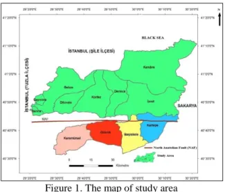
). Arıoğlu and Tokgöz evaluated quarries in and around the province of Istanbul based on several parameters. They prepared a report as a result of their evaluation. In the report, they examined these quarries based on research, operation permits, problems of quarries with expired permits, production and reserve capacity and the lithological, physical and mechanical characteristics of rocks (Arıoğlu and Tokgöz 1996). Nasser conducted a supply-demand analysis within the Colorado Denver Metropolitan area. According to the results of their analysis, they divided aggregate production areas into two groups as operational and potential areas (Nasser 1987). Erdoğan studied the distributions of the quarries, and the lithologic, chemical, physical, mechanical and technological properties of rocks in the quarries from west of Istanbul (Çatalca) to west of Kocaeli (Gebze) (Erdoğan 1993). Doğan et al., evaluated the general conditions of quarry mines and engineering propertiesof rocks in the quarries in Istanbul Province and its surroundings (Doğan et al 2003). The studied area covered the north of the province of Kocaeli (north of the Northern Anatolia Fault Line) in north-western Turkey (Figure 1).
Figure 1. The map of study area
The units in this area usually consisted of sedimentary rocks. Among these rocks, especially limestone and dolomitic limestones had a broad area of distribution, while the dolomite clast contents were high and slightly separated. Due to such characteristics, these rocks were determined to be more suitable for usage as concrete aggregates, road aggregates and filling material (Erkol and Aydındağ 2012). The units on which the existing aggregate quarries in the examined area were operational were demonstrated based on their locations with the help of a geographical information system (GIS). The areas that could have potentials were divided into certain regions (Demir 2010). Karakaş and Coruk evaluated aggregate supply-demand status by monitoring the flow of aggregate distribution over the transportation network in the “Front Range Corridor” area of the State of Colorado (Karakas and Coruk 1999). Kerri, Ferbey and Levson determined potential aggregate resource areas for Northwestern British Columbia (Canada) by using GIS remote sensing and GPS (Kerr et al 2005). The most important purpose for using GIS in this study was to helping easiness in tangible modelling for aggregate areas that might have a potential. For this purpose, in the system, certain criteria (geology of the investigated area, roads, elevation settlement status and land usage) were determined, and with the help of these criteria,areas that could be potential sources were determined.
2. Materials and Methods
A GIS (Geographical Information System) was used as the material to determine the aggregate areas in the studied region that were operational and those that could have a potential.
Method: With the help of the GIS, the studied area
was analyzed in two parts. The first part consisted of those that wasoperational in the year 2010, while the second part consisted of those that could have a potential. In the examined area, there were 14 different crushed rock quarries. 10 of these were in and around the district of Gebze, while 4 were in the Körfez-Derince area, and there were none in the Kandıra-İzmit area. The quarries in and around Gebze usually consisted of units of limestone and dolomitic limestone (Table 1). Previous studies determined the petrographic, chemical and mechanical properties of these units, as well as their potentials of becoming aggregates, by using various experiments. To determine the physical and mechanical characteristics of aggregates, dry unit weight, effective porosity and uni-axial compressive strength experiments were carried out, while specific weight, water absorption, fine material rate, Los Angeles abrasion rate, flatness and length index experiments were conducted to assess their usability as aggregates (Table 2).
With the data that were obtained, the aggregates were evaluated in terms of the areas where they could be usable. Among these areas of usage, the most frequently encountered ones were ready-mixed concrete, asphalt, fertilizer industry, filling, road and infrastructure materials, as well as raw material for cement [10]. The aggregate units that were operated in the Körfez-Derince region consisted of limestones in the lithologic sense (Table 3).
To determine the physical and mechanical characteristics of aggregates, dry unit weight, effective porosity and uni-axial compressive strength experiments were carried out, while specific weight, water absorption, fine material rate, Los Angeles abrasion rate, flatness and length index experiments were conducted to assess their usability as aggregates. These results are given in Table 4 (Zarif et al 2003).
The aggregates that were obtained from the crushed rock quarries were used in concrete, asphalt, filling materials and road construction. There was no aggregate quarry in the İzmit-Kandıra region. However, the unique Kandıra stone was processed there. It was determined that the aggregates in this region consisted of biomicritic limestone units in the lithologic sense (Tansel 1989). These units are soft and have a homogenous structure, while they do not
contain crack fillings that lead to changes in hardness and characteristics or mineral irregularities. Due to such characteristics, they are used in cutting or decorative stones, façade and garden wall covers, paving stones and barbecue and fireplace construction. The destruction caused by the 1999 earthquake in the region, increased population and large-scale projects like MARMARAY have led people to search for new aggregate resources. For this reason, determination of new aggregate resource areas has great importance for the province of Kocaeli in the economic sense (Karakaş 2014). The potential aggregate regions in the north of Kocaeli were evaluated by a GIS based on certain criteria (classified geology, elevationroads, settlement status and land usage). As a result of the assessment, the areas where aggregates could be obtained were classified as low, medium, good and high levels. Geologically, the studied area usually consisted of sedimentary rocks. However, there were occasionally magmatic and metamorphic rocks, too. Magmatic rocks have a stronger structure in comparison to sedimentary and metamorphic rocks. This is why the aggregates obtained from these rocks have higher quality in comparison to others. However, the granites in the studied area in the magmatic rock group had very thick separation characteristics. Aggregates to be obtained from these units might not have much quality. This is why these units were assessed as low-level aggregate potentials (LLAP). As another member of the magmatic rock group, the volcanites in the studied area had relatively thicker tuff and agglomerate contents and limited fresh lava levels in occasional places, and therefore, they were considered to be medium level (MLAP). In the metamorphic rock group, chlorite schist, epidote schist and sericite schist covered a very small area. As these rocks had experienced metamorphosis, they were considered to have a medium-level aggregate potential. Sedimentary rocks constituted a large part of the studied area. Especially limestones in this rock group were the most frequentlyobserved and had the highest quality, while they were divided into different classes of potential based on their copresence with different units (Table 5). These were considered to have low-, medium-, good- and high-level aggregate potentials (LLAP, MLAP, GLAP, HLAP).
While determining the potential areas within the studied area, land usage was considered as the second criterion. In areas where aggregate quarries would be established, the operations of such quarries would lead to environmental pollution, and as a result of explosions, mudslides, rock falls and tremors on the ground. In order to minimize the negative effects of such issues, attention should be paid to select areas
outside settlement areas and agricultural land, while choosing areas close to main roads for the sake of cost minimization. It was observed that the quarries that were operational in the studied area were established on agricultural lands. These agricultural lands turned tounproductive for this reason. The land usage statuses in the studied area were of Classes I to VII, including 7 classes in total (Table 6).
The studied area was assessed based on the parameter of elevation and it was observed that the land consisted of different layers of elevation levels starting at the sea level. This is why the studied area was divided into 4 classes of elevation, as 0-200 m, 200-400 m, 400-600 m and 600-640 m (Table 7). The greatest effect of the elevation parameter in determining aggregate potential is that it affects operational costs.
Considering the aggregate areas that could have a potential in the studied area based on the parameter of road status, the most important factor is the proximity to main roads. This is because this distance significantly affects the costs of transporting the aggregate that is obtained from the quarry to the place where it will be used. As the province of Kocaeli is an industrial province and a transition point between Istanbul and Ankara, its roads are developed. This is why it is desired to establish aggregate and crushed rock quarries at places close to residential areas and concrete stations. In short, considering the road status in terms of aggregate production, as the distance to main roads increases, costs will also increase, and this is why roads are an important factor for determining aggregate potentials. Thus, as a main factor that affects costs, distance to main roads was considered. Here, these distances were evaluated as very far from main roads (farther than 60 km), far from main roads (20-60 km), close to main roads (5-20 km) and very close to main roads (0-5 km) (Table 8).
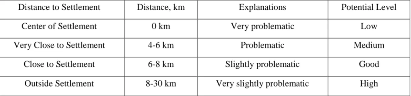
The studied area was finally evaluated in terms of settlement status. The evaluation included firstly Gebze and its surroundings as it is an industrial zone, secondly İzmit Bay coastal line and finally the district of Kandıra. Due to the presence of several industrial facilities in this region and the fast increase in settlement areas, the need for aggregates increased. In the environmental sense, quarries established within residential areas lead to several problems such as air shock as a result of explosions, tremors on the ground, loose rocks and dust that result out of breaking and sieving. These make it difficult for crushed rock quarries to be operated economically and continuously. Aggregate production areas based on their locations of operation relative to settlement
areas were evaluated under 4 categories as very problematic areas in the center of residential areas (0 km), problematic ones very close to residential areas (5-6 km), slightly problematic ones close to residential areas (6-8 km) and very slightly problematic ones outside residential areas (8-39 km) (Table 9).
The aggregate areas that could have potential in the north of the province of Kocaeli were evaluated in the GIS based on geological unit, land usage, elevation, roads and settlements, and the areas with low-, medium-, good- and high-level potentials were determined (Table 10).
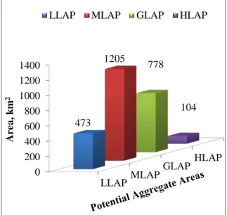
A chart was created to show the LLAP, MLAP, GLAP and HLAP areas that were determined with the help of the GIS and how much area they covered (Figure 2). In this chart, LLAP (low-level aggregate potential) took an area of 473 km2, MLAP
(medium-level aggregate potential) covered 1205 km2 of area,
GLAP (good-level aggregate potential) had an area of 778 km2, HLAP (high-level aggregate potential)
covered an area of 104 km2. Accordingly, in the
studied area, MLAP had the highest land area, while HLAP had the lowest.
Figure 2: Distribution of the potential aggregate areas
3. Results and Discussion
The studied area consisted of magmatic,
metamorphic and sedimentary rocks, while the most suitable ones were sedimentary rocks in terms of their potential to be aggregates.
In the group of magmatic rocks, granites were considered to have a low-level aggregate potential (LLAP) as they had very thick separation characteristics, while volcanites were accepted to have a medium-level aggregate potential (MLAP) as they had relatively thicker tuff and agglomerate levels, limited thickness of fresh lava levels and the occasional presence of them.
In the group of metamorphic rocks, chlorite schist, epidote schist and sericite schist were considered to have MLAP as they surfaced in a very limited area and had been exposed to metamorphosis. Sedimentary rocks constituted a large part of the studied area. Especially limestones in this rock group were the most frequently observed and had the highest quality, while they were divided into different classes of potential based on their copresence with different units.
For the aggregate material obtained from the operated quarries, the most frequent usage areas were ready-mixed concrete, fertilized industry, filling, road and infrastructure materials, as well as cement raw material, based on previous studies.
When the locations of 14 different existing aggregate quarries were visualized on the geological map that was prepared by using the GIS, it was determined that they processed units of limestone and dolomitic limestone.
By using GIS, the areas in the north of Kocaeli with the potential to be sources of aggregates were determined based on geological units, land usage, elevation, roads and settlement areas. In this process, a chartand a map were created to show the areas that could have low, medium, good and high potentials for aggregates.
With the help of this map, the areas suitable for processing the units in the north of the province of Kocaeli as aggregates were modelled, and this resulted in this preliminary study which may be guiding for firms or individuals who will operate such quarries.
References
ARIOĞLU, E. ve TOKGÖZ, N., (1996). “Kırmataş Ocakları ve Kısa Bir Değerlendirmesi”, Maden Mühendisleri Odası İstanbul Şubesi Çalışma Raporu, T.M.M.O.B., Sayı:1 , No:1, İstanbul. ARIOĞLU, E. (2003). Agrega Sektörüne Genel Bir
Bakış, 3. Ulusal Kırmataş Sempozyumu, İstanbul. LLAPMLAP GLAPHLAP 0 200 400 600 800 1000 1200 1400 473 1205 778 104 Are a , k m 2
ERDOĞAN M., (1993). Artificial aggregate potential of Istanbul and its surroundings. Bulletin of
Engineering Geology Turkish National
Committee, No:14, pp 29–41, Istanbul.
DEMİR, D. (2010) Kocaeli Kuzeyinin Agrega Potansiyelinin Belirlenmesi, Kocaeli Üniversitesi Fen Bilimleri Enstitüsü, Yüksek Lisans Tezi, 147s.
DEVLET PLANLAMA TEŞKİLATI, (2001). “Endüstriyel Hammaddeler” 1. Madencilik Özel İhtisas Komisyonu Raporu, DPT–2615-ÖİK: 626, Ankara.
DOĞAN T, KARADOĞAN A, KAHRİMAN A and DURDU I. (2003). General View to Quarry Mines in Istanbul Province and its Surroundings. 3rd National Crushed Aggregate Symposium, Istanbul.
ERKOL, D., ve AYDINDAĞ, A. (2012). Gebze (Kocaeli) Agrega- Kırmataş Maden Jeolojisi, MTA Doğa Kaynakları ve Ekonomi Bülteni, 16. Sayı, S. 241-243,
ESENLİ, V. (1996). Kırmataş Hammaddeleri ve Standartları,1. Ulusal Kırmataş Sempozyumu, İstanbul.
NASSER, K. (1987). Supply and Demand Analysis in the Denver Metro Area, Jefferson County
Planning Department, Colorado, 20.
KARAKAŞ, A., ve CORUK, Ö. (1999) Agreganın Ocaktan Kullanım Alanına Ulaştırılmasında CBS Uygulamaları, 2. Ulusal Kırmataş Sempozyumu, İstanbul.
KARAKAŞ, A. (2014) Defining the suitability of new crushed rock aggregate source areas in the North of Kocaeli Province using GIS., Bulletin
of Engineering Geology and the Environment,
73, 1183–1197.
KERR B., FERBEY T., and LEVSON V.M. (2005). Implementing Geomatics Technology For Aggregate Exploration, BC Ministry of Energy
and Mines, Northeast British Colombia, 76-79.
TANSEL, İ. (1989). Ağva (İstanbul İli) Yöresi Geç Kretase İstifinin Foaminifer Biyostratigrafisi”,
Yerbilimcinin Sesi.
ZARİF, H.İ., TUĞRUL, A., DURSUN, G., (2003). İstanbul’daki Kireçtaşlarının Agrega Kalitesi Yönünden Değerlendirilmesi, İstanbul
Üniversitesi, Mühendislik Fakültesi,
Appendix
Table 1: General Information on Quarries in and around Gebze (Modified from [7])
No Firm Name Quarry Location Quarry Ownership Status Date of Starting Production Lithology Annual Production, ton Sales,
ton/year Usage Areas
1 Aytaç Ayhanlar Madencilik Gebze Forest-Privately Registered Land 1997 Dolomitic Limestone 1.5-2.5 million 1.5-2.5 million Ready-mixed concrete, asphalt and fertilizer industry 2 De-Taş
Madencilik Gebze Forest 2000 Limestone 350.000 350.000
Ready-mixed concrete 3 Kancataş
Maden Gebze Forest 1995
Dolomitic Limestone 1.5-2 million 1.5-2 million Concrete and asphalt 4 Kibsaş Maden Gebze Forest-Privately Registered Land 1988 Limestone 1.5 million 1.5 million Concrete, asphalt, filling, road and infrastructure material 5 Koca Beton Agrega Madencilik Gebze * * Limestone * * * 6 Laferge
Beton Darıca * * Limestone * * *
7 Madeks
Madencilik Gebze Forest 2006 Limestone 1.5 million 1.5 million Concrete and road construction 8 Maden Yapı Beton Madencilik
Gebze Forest 2002 Limestone 2-2.5 million 2-2.5 million Concrete, asphalt and cement raw material 9 TCT İnş. Maden Gebze Forest-Privately Registered Land 2004 Dolomitic Limestone 1.5-2 million 1.5-2 million Concrete and asphalt
10 Akçansa Çimento Gebze Forest 1994 Limestone 2 million 2 million
Ready-mixed concrete, asphalt, filling and infrastructure material *Infırmation not provided
Table 2: Experimental analysis results for aggregate quarries in and around Gebze Specific Weight Gs Dry Unit Weight γd, ton/m3 Water Absorption Wa, % Effective Porosity ne, % Uni-Axial Compressive Strength σc, kg/cm2 Resistance to Sodium Sulfate (Na2SO4), % Los Angeles Abrasion Value (500 rev.) , % Flatness Index, % Length Index, % 2.71-2.84 2.71-2.82 0.30-0.47 0.98-1.55 1050-1280 1.7-2.2 19.2-21.6 17.9-18 27.1-28.4
No Firm Name Quarry Location Quarry Ownership Status Date of Starting Production Lithology Annual Production, ton Sales
,ton/year Usage Areas
1
Me-ka Küçükkaya Madencilik
Hereke Forest 1998 Limestone 500 thousand
- 1 million 1 million Concrete, asphalt and road construction 2 Örgüç
Madencilik Hereke Forest-Mine 1969 Limestone 600.000 600.000
Ready-mixed concrete 3 Özmaş Müt. Ve Tic. A.Ş. Hereke Forest 1998 Limestone 1 million 250
thousand 1 million 250 thousand Concrete, asphalt and filling 4 Simgekocafalt Kocaeli Asfalt İnşaat Madencilik ve San.
Hereke Forest 2003 Limestone 1 millon 250 thousand
400-500
thousand Asphalt
Table 4: Experimental results on the aggregate quarries in the Körfez-Derince region.
Specific Weight Gs Dry Unit Weight γd, ton/m3 Water Absorption Wa , % Effective Porosity ne , % Uni-Axial Compressive Strength σc, kg/cm2 Resistance to Sodium Sulfate (Na2SO4), % Los Angeles Abrasion Value (500 rev.) , % Flatness Index, % Length Index, % 2,69 2,66 0,65 2 760 0,45 21 21,4 34,8
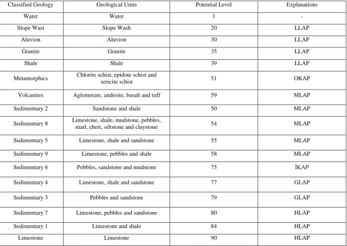
Table 5: Assessment of geological units based on their aggregate potentials.
Classified Geology Geological Units Potential Level Explanations
Water Water 1 -
Slope Wast Slope Wash 20 LLAP
Aluvion Aluvion 30 LLAP
Granite Granite 35 LLAP
Shale Shale 39 LLAP
Metamorphics Chlorite schist, epidote schist and
sericite schist 51 OKAP
Volcanites Aglomerate, andesite, basalt and tuff 59 MLAP
Sedimentary 2 Sandstone and shale 50 MLAP
Sedimentary 8 Limestone, shale, mudstone, pebbles, marl, chert, siltstone and claystone 54 MLAP
Sedimentary 5 Limestone, shale and sandstone 55 MLAP
Sedimentary 9 Limestone, pebbles and shale 58 MLAP
Sedimentary 6 Pebbles, sandstone and mudstone 75 İKAP
Sedimentary 4 Limestone, shale and sandstone 77 GLAP
Sedimentary 3 Pebbles and sandstone 79 GLAP
Sedimentary 7 Limestone, pebbles and sandstone 80 HLAP
Sedimentary 1 Limestone and shale 84 HLAP
Limestone Limestone 90 HLAP
Land Classes Land Status Potential Level Explanations Potantial Level Class I land Agriculture-settlement-industry 30 Aggregate production not
suitable Low
Class II land Settlement-low agriculture area 50 Aggregate production
slightly suitable Medium Class III land Settlement-industry 50 Aggregate production
slightly suitable Medium Class IV land Industry-low settlement area 70 Aggregate production
suitable Good
Class V land Field-orchard-pasture 70 Aggregate production
suitable Good
Class VI land Forest-pasture-forage 90 Aggregate production very suitable High
Class VII land Settlement area 30 Aggregate production not
suitable Low
Table 7: Determining aggregate potentials based on elevation
Elevation Classes, m Elevation Status Explanations Potential Level
0-200 m Very low parts Costs very suitable High
200-400 m Low parts Costs suitable Good
400-600 m High parts Costs slightly suitable Medium
600-640 m Very high parts Costs not suitable Low
Table 8: Determining aggregate potentials based on road status.
Distance to Main Roads Distance, km Explanations Potential Level
Very far Over 60 km Very high costs Low
Far 20-60 km High costs Medium
Close 5-20 km Low costs Good
Very Close 0-5 km Very low costs High
Table 9: Determining aggregate potentials based on settlement status.
Distance to Settlement Distance, km Explanations Potential Level
Center of Settlement 0 km Very problematic Low
Very Close to Settlement 4-6 km Problematic Medium
Close to Settlement 6-8 km Slightly problematic Good
Outside Settlement 8-30 km Very slightly problematic High
Aggregate
Potential Classified Geography Land Status Elevation Road Status Settlement Status LLAP
Aluvion, water, granite, slope wash and shale
I (agriculture-settlement-industry) and VII (settlement)
600–640 m Very Far (over 60 km)
Center of Settlement (0 km)
MLAP
Sedimentary 2 (sandstone and shale), sedimentary 5 (limestone, shale, sandstone and marl), sedimentary 8 (limestone, shale, mudstone, pebbles, marn, chert, siltstone and claystone), sedimentary 9 (sandstone, pebbles and shale),
metamorphic (chlorite schist, epidote schist and sericite schist) and volcanites
(agglomerate, basalt, andesite and tuff)
II (settlement-low agricultural area) and III (settlement-industry)
400–600 m Far (20-60 km ) Very Close to Settlement (4-6 km)
GLAP
sedimentary 3 (pebbles and sandstone), sedimentary 4 (limestone, shale and sandstone) and sedimentary 6 (pebbles, sandstone and mudstone)
IV (industry-low settlement area) and V (field-orchard-pasture) 200–400 m Close or Could Be Close (5-20 km) Close to Settlement (6-8 km) HLAP limestone, sedimentary 1 (limestone and shale) and sedimentary 7 (limestone, pebbles and sandstone) VI. (forest-pasture-forage) 0-200 and 200-400 m Very Close (0-5 km) Outside Settlement (8-30 km)
![Table 1: General Information on Quarries in and around Gebze (Modified from [7])](https://thumb-eu.123doks.com/thumbv2/9libnet/3939198.50115/6.918.114.806.132.802/table-general-information-quarries-gebze-modified.webp)