IMPACT OF ESTABLISHMENT OF BEHESHTABAD TUNNEL ON
SHAHREKORD AQUIFER
Rahim Alimohammadi
Ph.D. Water Resources Sciences, Assistant Professor, Agricultural Engineering Department Agricultural and Natural resources Research and Training Center, Shahrekord, Iran
[email protected] ABSTRACT
Disturbing balance between supply and demand for water in different societies has raised the issue of inter-basin water transfer that associates one of the primitive, outdated and expensive way. In order to clarify the minimal impact of Beheshtabad tunnel that passes at depth of 300 meters below ground level at the Shahrekord plan, this research project was conducted for two years in the region. To facilitate the issue, software Modfow was used and also water balance equation was used for simulating the behavior and reaction of the Shahrekord plain groundwater. Due to the limited thickness of the aquifer and aquifer negative during water balance during the past 8 years (from 2007) which have received a drop of at least equal to 15.5 m, Beheshtabad tunnel with a length of 65 km, diameter of 4 meters and two access tunnels in Shahrekord plain and existence of many faults in the region that act as a powerful drain, and in less than 300 days, the tunnel can discharge the whole water stored in several centuries across the aquifer, upon evacuation of groundwater and entry of air in the empty space, the earth layers will become dense and ground collapse will occur. The minimum water requirement of the region (without considering the development in the area) is 236 million cubic meters annually.
Keywords: inter-basin water transfer, water balance equation, Beheshtabad tunnel, Jahanbin catchement area, Shahrekord plain
INTRODUCTION
Population growth, the fact that some regions are immigrants’ destination due to investment and development of industrial infrastructure in semi-arid and arid areas and increased demand for water are among the causes of disturbed balance between water balance equation and occurrence of serious challenges, which are sometimes regional and sometimes national. Inter-basin water transfer is one of the first, simple, challenging and somewhat outdated methods, which is used in some areas due to political and administrative backing and implemented using national funds. The changes and climatic abnormalities, creating expectation, creating impression of false rights for people, strengthened extravagance a major part of the population towards natural resources, especially water and soil, which increases water demand, and the constancy and sometimes reduction of the amount of supply and disproportionate temporal and spatial distribution of precipitation, conversion of precipitation of snow to rain and lack of snow storage in winter and early spring and lack of the gradual penetration of snow stored on the surface of a catchment area, always create serious challenges with regard to water supply and demand. Jahanbin catchment area with an area of 1260.3 square kilometers (7.7% of the area of the province) and population of 247628 (27.6 percent of the population) [1], including plains and catchment areas of Shahneshin, Bon, Tumanak, Vardanjan, Nafech, Pirbaloot, Chaleshtar, Shahrekord, Farokhshahr, Hafshejan and Shamsabad, which are of particular importance in terms of productivity, size, slope, climate and yield. Studies of phase of knowledge of Beheshtabad project for transfer of water of Beheshtabad tunnel was completed in 2004. Phase I studies was conducted in 2008 and in a single option form (transmission by tunnel), in which the sole option considered was excavation of a 65 km long tunnel with diameter of 4 meters at depth of 300 to 2000 meters under lands located in east of the province. Project components include: Beheshtabad Reservoir Dam after intersection of Beheshtabad and Koohrang Rivers, 65 kilometer tunnel from Tang-e Beheshtabad to Baghbahadoran city with a capacity of 1100 million cubic meters per year (initial plan), 746 million cubic meters per
year (in the First Phase Studies) and 580 million cubic meters annually in a water allocation letter (2010) [2]. Among the most important social effects of inter-basin water transfer are increased poverty and public discontent, increased migration, occurrence of injustice and increase suspicions, frustration and disappointment among residents of the catchment area due the loss of some opportunities [3]. The most important problems are caused by TBM drilling machine when passing through faults, which is usually associated with rush of water from karstic holes and fault zones during the drilling and failure of machinery when advancing in the faults [4], [5].
Factors that make Beheshtabad tunnel project complex include: maintaining vital balance of water resources, the long length of the tunnels, the need for heavy structures, high investment, expansion of areas affected, risks of water transfer, political issues and exact study of impact of water transfer before implementation in terms of physical, social, economic, biological and environmental factors in order to maintain environmental balance [6]. According to Minister of Energy (Hamid Chitchian), the effect of climate change on drying of Aral Lake and the Great Salt is 2 to 3 percent and the other 97 percent is the result of mismanagement and the wrong decisions [7]. Unauthorized and inappropriate use of groundwater resources and of unauthorized excavation of wells and lack of sustained engagement mechanisms with indigenous people are the reason for the drying of Lake of Urmia [8]. Price per cubic meter of water in the inter-basin water transfer projects are often based on the quantity and quality of investment, operation and management of the project according to the conditions of and consumers and the demand and supply of water. In China in 2020, four Yuan shall be paid per cubic meter of water consumed, but actually they will pay 5.06 Yuan, which may slightly vary according to useful life of the project and loans, operations, management and financial abilities precious [9]. It was concluded from study of basin water transfer projects from 1900 till 2014 in the world that inter-basin water transfer is one of the most challenging of the world's water supply solutions. Inter-inter-basin transfer of water from one basin to another shall pose new challenges and crises to every two basins [10]. In a study on inter-basin transfer of water in semi-arid region of northeastern Brazil, it was confirmed that in projects of inter-basin water transfer, due to the need for massive investment, and to complicate things, usually a relatively large interval exists between the study and implementation of project and that it is better to spend such time on obtaining public satisfaction, political support of regional and national environment legislation and put the plan to discussion between stakeholders [11]. The complexity of the issues involved in implementing such projects, especially from the technical and management view, is very important. However, to avoid the various problems caused by reduced water level in the aquifer and challenges such as drying of wells, reduced revenues, increased costs, undermining the economic situation of farmers, rising unemployment, migration and prevention of land collapse, integrated management of water resources in the catchment area and to calculate supply and demand of water in the region, simulation and analysis of groundwater level was conducted using Modflow software with respect to the scenario of establishment of Beheshtabad tunnel and therefore analysis of water balance equation in the whole region and provision of integrated management plan for aquifer, and provision of strategies for strengthening water resources of Shahrekord aquifer are necessary. Therefore, knowledge of behavior of the aquifer and catchment area with focus on establishment of Beheshtabad tunnel on Shahrekord aquifer, the estimation of the real needs of consumers in different sectors (agriculture, industry and drinking) and calculating and predicting the water supply are necessary.
MATERIALS AND METHODS
The research was conducted in Chaharmahal va Bakhtiari province, city of Shahrekord located between Bon (Gerdab Bon) and Kharaji. Catchment area was located in the geographic area of 458 659 - 515 646 E and 3,550,637 - 3,603,702 N. Based on the classification of climatic and bioclimatic of Iran according to Gosen method, it is located the area of steppe and cold climate and according to Emberger method, the region is arid. In this study, synoptic stations statistics of Shahrekord, at an altitude of 2066 meters above sea level, average annual precipitation of 325 mm and in eight years period (2007-2015) 299 mm, minimum, maximum and average temperatures of respectively 42, -32 and 11 °C were obtained, mean relative humidity was 34% and the annual evaporation was 2575 mm. Shahrekord plain has 854deep and semi-deep wells (agricultural: 571 wells (with discharge of 78.75
million m3/year), industry: 167 wells (54.2 million cubic meters per year) and drinking water: 116 wells (46.4 million cubic meters per years).
Soil textures are different in different regions. However, they are often light to semi-heavy texture in northern areas, alluvial deposits with specific resistance ranging from 15 to more than 100 ohm-m are found on the floor resistant rocks (Cretaceous limestone). Maximum thickness of alluvium in these areas is more than 100 meters [12]. Meteorological data (average minimum and maximum monthly temperature, relative humidity, wind speed, sunshine, and evaporation, precipitation daily and monthly) were obtained from the Meteorological Administration. Also statistics related to monthly fluctuations of groundwater level of Shahrekord along with data from observation wells and complete data from drilled wells and operating wells in Jahanbin Catchment area were obtained from regional water authority of the province. Also, in collaboration with experts and technicians of that authority, the output runoff of catchment area at Tang-e Kharaji were measured monthly during project. Information on area under cultivation and cropping pattern were obtained from Agricultural Organization and Management of Jihad Keshavarzi of Shahrekord city. Water balance of catchment area and plain was calculated using the following equation:
Water input - output water ± changes in storage volume of surface and groundwater resources = zero Water input = precipitation + wastewater + inflow from neighboring catchment areas
Output water = water extracted + water existing the catchment area or specified element + evapotranspiration
Drinking water requirement was calculated using the population statistics from the planning and budget planning organization, Deputy Governor of the province and their analysis using proper growth rate and considering future policies, migration and regional issues in the region. Current and future water requirements of the industrial sector were calculated according to provincial policies and programs of relevant agencies as coordinated with them. Plain unit hydrograph was conducted using groundwater level fluctuations and polygons of Thiessen method. Scenarios envisaged included: normal and standard state that was considered for the circumstances of 2013-2014. And scenario of establishment of Beheshtabad tunnel. All the different modes were simulated by Modflow model [13]. The results obtained from the model (simulated) were compared and analyzed with values of groundwater for base months (October 2013-2014) to evaluate the effect of establishing Beheshtabad tunnel to transfer water from the Beheshtabad dam to the Chamaseman dam in Isfahan. Drawing graphs was conducted using Excel software, tables were prepared using Word, evapotranspiration and water requirement were calculated by Crop Wat, digital mapping was conducted using GIS, and analyzing groundwater level and required forecasting were done using Modflow.
RESULTS
Jahanbin catchment area with an area of 1260.3 kilometers and plain area of 456 square kilometers, with 854 active and semi-deep wells (agricultural: 571 wells (with discharge of 78.75 million m3/year), industry: 167 wells ( 54.2 million cubic meters per year) and drinking water: 116 wells (46.4
million cubic meters per years). it also contains 27.66 percent of the population of the prince and 7.7 percent of the area of the province. the lack of balance between supply and demand (consumption ) of water in Jahanbin aquifer and increasing water intake and negative balance of Shahrekord plain aquifer from water year of 2006-2007 to 2013-2014 and 14.92 meter reduction of groundwater level in the last seven years (Fig. 1) double the importance and requirement of planning and optimal use of the area of the aquifer. Study of changes of groundwater level of Shahrekord plain between 2004 and 2014 as shown in Fig. 1 and reduction of groundwater level of the plain started from 2006-2007, which indicates the direct effect of rainfalls, The rate of aquifer recharge, prevention of the outflow of runoff, extraction and use of water resources in the past seven years in declining trend of hydrograph of Shahrekord unit. The plain unit hydrograph showed that there was clear plan regarding water withdrawals from the aquifer region and the non-observance of relevant requirement by beneficiaries of the exploitation of the plain during wet and dry years.
Figure1.
The volume of surface runoff from the catchment area (Kharaji Tang) in the project years (2011 till 2014) was measured in cooperation with the Regional Water Authority of the province. And statistics on a number of years the company before the year 2011 (Fig. 2) was obtained from the Authority. The output runoff from the catchment area especially during the three years of the project caused by the outflow of springs located on the hillside of Jahanbin Mountain and wastewater of homes (Shahrekord, Kian and Farokhshahr houses) were respectively 17.3, 18.6 and 17.4 million cubic meters per year. Because, no runoff came from the main river of catchment area.
Figure (2) Changes in annual precipitation and annual output surface runoff of catchment area Catchment area’s water balance in the first year of the project (2011-2012), the volume of input water of 185.87 million cubic meters, the volume of water leaving the system is 223.16 million cubic meters, which cause negative balance and yield of 37.1 million cubic meters in the system and negative balance and yield of aquifer resulted in drop of 1.73 meter in groundwater levels (Fig. 1).
Even in the year 2012-2013 when precipitation was higher than normal annual one, yield of system was negative in the area so that groundwater level drop of 1.03 occurred and during the three years of the implementation of the plan for the level of groundwater table, it experienced a 5-meter drop (Fig. 1).
IMPACT OF WATER TRANSFER THROUGH BEHESHTABAD TUNNEL
Water Tunnel of Beheshtabad transfer water from the reservoir of Beheshtabad Dam (in Chaharmahal and Bakhtiari) located in Tange-e Beheshtabad with coordinates 465516/5, 3544513/8 meter to the area of the Chamaseman (518584/1, 3581361/9 meters) 65 km in length. Along Beheshtabad tunnel, ten fault systems, fault systems of Ardal, Hezargazi mountain, Zagros mountain, NW-SE faults, NE-SW faults, Shamsabad plain and Nesar heights, faults of Farrukhshahr Plain, Tange-e Sayad – more than 25 major faults and minor faults. It should be noted that of the border between tectonic zones is one of the most perilous regions of the earth crust that jeopardize every construction with unpredicted dangers. Existence of a complicated network of cross and reverse faults along the water tunnel with
intense karstification of formations belonging to the Cretaceous period (Sarvak) will bring numerous risks to tunnel [12]. This underground tunnel HAS different depths (300 to 2000 m) compared to the ground with 6 access tunnels [14].
This tunnel passes through the plains of Farsan, Shalamzar, Kiara, Sefid-dasht, Borujen and Shahrekord. By creating an outlet channel of karstic sources, hydrological balance of karstic resources will be destroyed and those resources will go often to the point of desiccation [4, 5]. According to the studies of consulting company, most of the springs and the region's water sources (Farrokh Shahr limestone wells, Dastana spring, Salm spring, Shamsabad spring and Chaharmahal and Bakhtiari plain water sources within Shamsabad (fault causing the hydraulic connection) will be dried [14]. in addition Shahrekord plan, Beheshtabad tunnel will negatively affect Farsan (Jownaghan), Kiara, Shalamzar, Borujen and Sefid-dashti; the condition of all the said plains will critical and associated with negative balance.
Access tunnel located in the catchment area are as follows:
1. Jahanbin access tunnel, the length of 2230 meters with a slope of 14% is located on the northeast slope of Jahanbin Mount. The tunnel with a 45-degree angle intersect faults at the eastern Jahanbin Mountain and is located near the flushing spring (time and hours) of Shamsabad.
2. Shamsabad access tunnel, with a length of 2230 meters in the East of Village of Shamsabad, with the slope of 14 percent. This is a rock tunnel that due to being under stress due to the Zagros orogeny is slated, and there are many small folds and faults in the region.
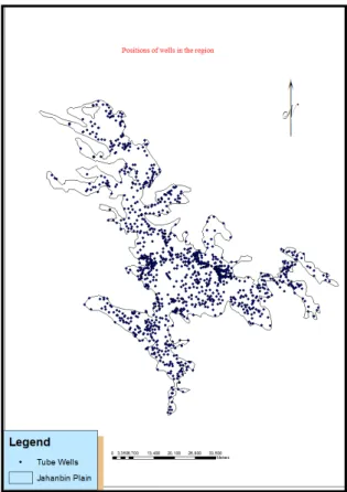
3. Farokhshahr access tunnel, at the beginning of the Gardanehrokh road with a length of 3100 meters in the North East of Farokhshahr that has a slope of 14 percent. In this area there is a slate structure as well. The beginning of tunnel has much fragmentation due to existence of faults and many folds and faults along with slated by joint and cleavage are seen in this area. Beheshtabad tunnel will pass through Jahanbin heights, Shahrekord Plain (Shamsabad range), Nesar heights, Farokhshahr area and in Kian City, protected heights of Tange-e Sayad. Area studied (Jahanbin plain) has 871 deep and semi-deep wells (Figure 3) has 36 observation wells. The analysis of the level of ground water table level was conducted using statistics of water table of the plain’s observation wells.
Figure (3) Position of drilled and exploiting wells in plain SCENARIOS:
A) Normal mode
Given the rainfall in years 2013-2014 (318.12 mm), consumption of agriculture sector (149.69 million cubic meters), industrial sector (21.5 million cubic meters) and drinking water and green space (47.64 million cubic meters) [13], if situation prevailing between the years 2013 till 2018 is the same as one during the years 2013-2014, there will be reduced groundwater aquifer equivalent to 17.8 m. And if this situation will continue until 2023, groundwater levels drop of 43.3 meter will occur. But if it continues or more critical condition occur, unfortunately catchment area will experience wells drying and depletion of water in Shahrekord aquifer (Fig. 4).
Figure 4. Comparison of changes in groundwater levels measured in 2013 with those estimated for years 2018 and 2025
(B) Excavation of tunnel of Beheshtabad scenario: In this scenario, prediction of excavation of Beheshtabad tunnel to transfer water from the Karoon basin to Zayandehrud basin (from the reservoir of Beheshtabad Dam or with length of 65 km to the lake of the diversion dam of Chamaseman in
Isfahan) located 300 meters below ground level in the Shahrekord Plain aquifer and Jahanbin catchment area (Fig. 5). Given faults and fractures in the area, construction of access tunnels and pass of water through aquifer, under any circumstances, in the event of establishment of tunnel of Beheshtabad, aquifer shall lose all of its water within 295 days after excavation, becoming completely devoid of water (Fig. 6). And during the exploitation of tunnel, only there would be very weak underground flows that will not meet the water requirement of the beneficiaries during the year. In other words, all the region's water resources, 854 deep and semi-deep wells will cease to exist forever. It should be noted that due to a weak underground currents, some wells will survive for a very limited time period (10-20 minutes per 5-10 hours) with limited water discharge. In this connection there may be the need that all the officials take special measures in the region for preventing establishment tunnel under any circumstances; and in the case of the construction, Ministry of energy it should place it as the first priority of the water requirement in the region, which now totals 236.22 million m3/year, as to the beneficiaries of Jahanbin catchment area.
Figure (5) The placement of Beheshtabad to Shahrekord plain tunnel
Figure (6) changes in average groundwater level after Beheshtabad tunnel excavation compared to the aquifer water level in the October of water year 2013-2014
CONCLUSION
Shahrekord aquifer groundwater levels since experienced 14.9 m drop between 2006-2007 and 2013-2014. For ease of analysis, Modflow software was used to simulate the behavior of the aquifer compared to normal state; in this case scenario of establishment of Beheshtabad 65 km long tunnels
with an internal diameter of 4 meters was considered and reaction of aquifer was analyzed. Because rainfall of 2013-2014 was consistent with the long-term average precipitation (318.12 mm), the water yield of the area in the same was used as base and normal (real) index. In the scenario envisaged, Beheshtabad 65 km long tunnel that passing at the depth of 300 meters through Shahrekord aquifer and Jahanbin catchment area will become unavailable because of various faults, fractures, thrust, making of three access tunnels in the basin, the seams in the area, after a short period of time (295 days) after the onset of tunnel excavation, and water stored in the aquifer over the years will be unavailable and aquifer will be faced with the phenomenon of definite collapse. Therefore, in order to preserve the life of shahrekord plain aquifer and water basin balance in the performance of jahanbeen catchment area, there is excessive need for the legal implementation of the integrated program of critical water resources management, with the executive support, with the aim of optimum consumption and sustainable development by relying on the actual operations of catchment area and definite removal of option of Beheshtabad tunnel construction. Because if this realizes, aquifer will lose water and collapse and the aquifer will cease to exist.
REFERENCES
Management and planning Organization (2011). Economic and Social Report. Management and planning organization. Chaharmahal va Bakhtiari province.
Samadi, H. (2011). Inter-basin water transfer (opportunities and challenges). Water Resources Research Center, Shahrekord University, p. 376.
Shamseddini, Sh. (2012). Economic and Social Impacts of inter-basin water transfer. National Conference on inter-basin water transfer (challenges and opportunities), Islamic Azad University of Shahrekord. .
Holter, K.G & Johansen, E. D. and Hegrenaes, A. 1996. Tunneling through a sanzone; Ground treatment experiences from the Bjoroy subsea road tunnel. Proceedings of North American tunneling, 96(1): 249- 256 Washington DC.
Shang, Y. &Sijing W. &Zhifa, Y. and Faquan, W. 2006. Lessons from one Tunnel Boring machine Priject in Kunming city, China. The geological society of London, IAEG 2006 paper number 717. The Halabian, M., Shabankary, M. (2010) Management of water resources in Iran (Case study: Challenges of water transfer from Beheshtabad to Zayandehrud). The fourth International Congress on Islamic World Geographers, Zahedan p. 13.
The Karimyfard, Sh. (20013). Detailed reports of the Fifth National Conference on Water Resources Management, with special approach towards the Lake. Shahid Beheshti University of Tehran, Faculty of Engineering, Campus of Shahid Abbaspour, p. 61.
Lar Consulting Engineers (2013). An overview of the status of rehabilitation of Lake and solutions. Ministry of Energy, p. 11.
Jiang, G. & Xia, Y. & Wang, D. & Jiang, S. and Cai, X. 2012. The Study of Analysis and Measurement of the Comprehensive Water Price through Interbasin Water Transfer. Advanced Materials Research Vols. 374-377 (2012) pp 230-237.
Zhang, L.& LI, S. & Loaiciga, H. A. & Zhuang, Y. and Du, Y 2015. Opportunities and challenges of inter basin water transfers: a literature review with bibliometric analysis. Scientometrics, 105:279– 294.
Geraldo, J. & Franco, P. S. & Souza, L. C. and Makino, D. L. 2011. Inter basin Water Transfers: The Brazilian Experience and International Case Comparisons .Water Resource Manage 25:1915–1934 Emami, S. N. (2002). Geologic challenges of inter-basin water transfer projects (Case study:
Beheshtabad to the central plateau water transfer project). National Conference on inter-basin water transfer (Challenges and Opportunities).
Alimohammadi, R. (2015). Quantitative simulation of groundwater of Jahanbin basin (Shahre Kord Plain) for sustainable use of the aquifer using Modflow model. Research Institute of Agricultural Engineering, p. 86.
Zayanab Consulting Engineers (2008). Report of studies on water transfer to the Central Plateau. Geological and geotechnical walls and groundwater and landscape design.