a
Ardahan University, Department of Geography, TR-75000, Ardahan, Turkey
b
Çanakkale Onsekiz Mart University, Department of Geophysical Engineering, TR-17020, Çanakkale, Turkey
cIstanbul University, Institute of Marine Sciences and Management, TR-34459, Istanbul, Turkey d
Beylikdüzü Municipality, TR-34520, Istanbul-Turkey
a b s t r a c t
a r t i c l e i n f o
Article history: Received 11 March 2012
Received in revised form 23 May 2012 Accepted 23 May 2012
Available online 30 May 2012 Editor: J. Knight
Keywords: Coquinite Cross-bedding Cementation
Electrical Resistivity Tomography (ERT) Thrace
Black Sea
In this paper, preliminary results concerning the nature, subsurface structure and age of carbonate-cemented coquinite extending along a 1.5-km long and 40-m wide loose coquina beach on the Thracian (west Black Sea) coast of Turkey are presented. An Electrical Resistivity Tomography (ERT) survey showed that the coquinite has a maximum thickness of about 2 m and comprises seaward dipping buried 20 m-wide slabs under beach materials at the backshore. Cemented by low-magnesian calcite, the coquinite contains various bivalvia, benthic foraminifera, calcareous nannofossils or coccoliths and quartz sands. Diagenesis of the coquinite occurred as the result of sequential cementation, starting with the precipitation of micritic en-velops typical of a marine phreatic zone. This early stage was followed by pore-lining cements and bladed rims composed of equal-sized subhedral and anhedral crystals of calcite, suggesting evidence of meteoric phreatic and meteoric vadose environments, respectively. Calibrated values from radiocarbon dating of four bulk samples of bivalvia revealed that the coquinite shells were deposited between 3730 and 2850 years BP. During that period the sea-level was similar to the present at an early stage then dropped to−2 m due to Phanagorian regression (between 3200 and 2200 BP), which is evidenced by consecutive ce-mentation patterns of distinctive origin.
© 2012 Elsevier B.V. All rights reserved.
1. Introduction
The Black Sea, an anoxic mass of water connected with the Mediterranean via the Turkish Strait System (Bosphorus, Dardanelles, and inland Sea of Marmara), has attracted intense attention after the study byAndrusov (1918). This interest was substantially due to the Black Sea's peculiar oceanographic characteristics and complicated history of sea-level changes during alternating interglacial and glacial periods (seeYanko-Hombach, 2007for detailed discussion). Changes during the glacial periods were independent of the global oceans according to Tchepalyga (1984). The hottest debates concerning the sea-level history of the Black Sea began whenRyan et al. (1997) proposed the idea of a catastrophicflood that contradicted Russian models of a gradual rise in sea-level. This opinion has been refuted in many ensuing papers (Aksu et al., 2002). However, the Holocene paleogeography of the Black Sea's coastal environment is mostly restricted to interpretation of sedimentological and paleontological evidence derived from bottom sediment deposits. Terrestrial-based records with regard to Late Holocene sea-level/coastline changes have largely been ignored.
In this paper, we present a new record of Late Holocene coquinite from Turkey's Thracian (Black Sea) coast based onfield observations, micro-analytical data and AMS14C dating results from bulk samples
of cemented fossil shells. Additionally, the subsurface nature of coquinites was determined by means of analyzing a high resolution Electrical Resistivity Tomography (ERT) survey. Despite extensive knowledge of the above-mentioned coastal rocks, there is little informa-tion concerning the nature, age and distribuinforma-tion of emerged Holocene coquinites on the world's coastlines with the exception of some studies on coquinites in east coast of Florida, North America (Rupert, 1989) and Haishan Island, South China (Sun et al., 2009). The existence of such carbonate-cemented shell debris on the Black Sea's long coastline is presented here for thefirst time and is of importance for our under-standing of sea-level changes in Late Holocene.
2. Study area
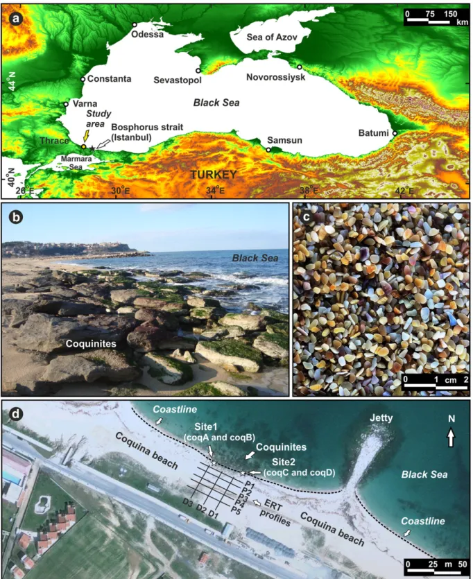
The study area is situated on the Black Sea coast of Turkey about 40 km northwest of the northern exit of the Bosphorus strait con-necting the landlocked Black Sea to the Sea of Marmara. The coquinite beds are located on the east coast of Karaburun on Çatalca Peninsula (Fig. 1a, b) along the northeastern Thracian coast of Turkey. The studied beach composed of mainly shell debris (Fig. 1c) is about 4.5 km long. Due to jetties as coastal defense structures, the width of the coquina beach ranges between 20 m and 60 m. Karaburun is
⁎ Corresponding author. Tel.: +90 478 2114132; fax: +90 478 2113275. E-mail address:[email protected](A.E. Erginal).
0037-0738/$– see front matter © 2012 Elsevier B.V. All rights reserved. doi:10.1016/j.sedgeo.2012.05.008
a small peninsula that protrudes into the Black Sea for some 600 m at an average width of 400 m. The peninsula is composed of a thick ma-rine sequence of mainly Oligocene age. Its geology has been studied previously byOktay et al. (1992)andSakınç (1994). From bottom to top, the Oligocene sequence is composed of cross-bedded pebblestone and mudstone that passes upward into claystone with lignite intercala-tions of Lower Miocene age (Sakınç, 1994).
The rainfall regime of the study area in terms of seasonality was classified in Türkeş (1996) as a transitional region between the
Mediterranean and Black Sea. Based on climate data between 1975 and 2006 recorded at Kumköy meteorology station (Fig. 1a), maximum and minimum precipitations are received in December (127.2 mm) and July (26.7 mm), respectively. The average annual precipitation is 831.4 mm. Minimum, maximum and average temperatures are 5.5 °C, 23.3 °C and 13.8 °C, respectively. The prevailing winds are from NNE and NNW. The average sea-water temperature is 14.3 °C, while the averages of lowest and highest values are 26.7 °C and 3.5 °C. Tidal range is rather low with an average of 10 cm (Goudie, 2001). Based
Fig. 1. Location of the study area, the black star shows the location of the Kumköy meteorology station. (a), dislocated blocks of coquinite due to wave Erosion (b), coquina beach material composed of quartz sand and shell debris (c), ERT survey lines and sampling sites (d).
ous outcrops along the studied coquina beach (Fig. 1b), two great massive blocks of cross-bedded coquinites larger than 2 m were selected. Four samples (about 20 cm in size) from bottom and upper levels were collected and sampling positions were recorded using GPS. For quantitative determination of element concentrations within the hash matrix of coquinite shells, Energy Dispersive Spectros-copy (EDX-Bruker AXS XFlash) analyses were performed. Scanning
Electron Microscopy (SEM-ZEISS EVO 50 EP) was used to define
micro-morphological features of the amalgamated components and for microfossil examination. For the foraminiferal analysis, a total of four coquina samples (average: 10 grams dry weight) was selected and samples were treated with 10% H2O2for 24 h, and then wet sieved
through a 63μm sieve. The remaining material on the sieve was dried in air and the benthic foraminiferal fauna were investigated under a binocular microscope. A subsample of each bulk sample was dated by the conventional radiocarbon method in Beta Analytic, Miami, USA. 3.2. Geoelectrical resistivity survey
ERT technique is frequently used for mapping near-surface mate-rials in both two (2D) and three dimensions (3D). Rapid and reliable data acquisitions by means of multi-electrode systems, advanced inversion algorithms and the resulting high resolution resistivity im-ages are the main advantim-ages of this technique (e.g.Ekinci and Kaya, 2007; Göktürkler et al., 2008; Rucker et al., 2010; Bekler et al., 2011). Thus an ERT survey was carried out to infer the parameters of the coquinites under the loose coquina beach, such as: lateral and vertical extensions, thickness, geometry and contact relationship (boundary) with coquina beach material (Fig. 1c). Three 40 m-long transects placed 15 m away from each other, perpendicular to the coast line (D1, D2 and D3), andfive 50 m-long transects, parallel to the coast-line (P1, P2, P3, P4 and P5), were realized for data acquisition where the coquinites are widely exposed throughout the coquina beach (Fig. 1d). The distances between the transects of P1–P2, P2– P3, P3–P4 and P4–P5 were 6 m, 8 m, 6 m and 8 m, respectively. Dipole–dipole electrode array configuration was used with electrode spacings of 2 m and 4 m for 9 depth levels along each line. In order to enhance the quality of the data 6 stacks (repeated measurements) were performed in each data point. A total of 1233 apparent resistivity data was acquired during the survey using GF ARES multi-electrode resistivity-meter system.
The processing of apparent resistivity data to produce geoelectrical tomographic images was conducted by 2D automatic inversion soft-ware RES2DINV (Loke and Barker, 1996). The tomographic inversion al-gorithm is based on smoothness-constrained least-squares (Sasaki, 1992) implemented by a quasi-Newton optimization technique (Loke and Barker, 1996). The object of the optimization is to search for a resis-tivity distribution that agrees with the measured data by minimizing the difference between measured and calculated apparent resistivity values using an iterative scheme. Calculations of the apparent resistivity values were carried out using thefinite-element method. Due to the
to heavily cemented by calcium carbonate. It forms in near-shore shallow waters including mainly shoals (Wilson, 1975), beaches, bar-rier bars and raised sand banks, which is a distinguishing feature that separates it from similar cemented coastal rocks such as intertidal beachrocks and eolianites. To the east of Karaburun port, the outcrops are found between rock-fill breakwaters constructed to protect the beach from violent sea waves (Fig. 1d). Much of the beach where the coquinite beds emerge is composed of coquina, which is made up of predominantly angular, polygonal or ellipse-shaped shell fragments. The long and short axes of shells were measured to be an average of 3.3 mm and 2.1 mm, respectively.
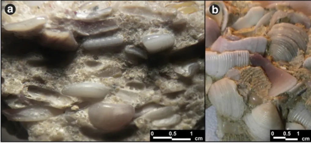
The outcrops, colonized to varying degrees by the seaweed Entero-morpha spp., are discontinuously exposed due to severe erosion and extend along the 1.5-km long and 40-m wide cemented coquina beach, which terminates near an open-pit lignite mine to the east. In-dividual stone blocks smaller than 1 m in size are either overlapping due to wave action or collapsing into the sea (Fig. 1b). The thickness of beds varies between 50 cm and 1 m. Comprising shelly layers and, to a lesser amount, angular sands, cross-bedding is very common and is identified by cm-thick bed with cross-bed angles occasionally steeper than 10°. Due to compaction, shell fragments exhibit very close packing (Fig. 2a), which is a typical feature of coquinites (Le Blanc and Breeding, 1957). The mechanically-sorted tiny shell debris with a fresh appearance is mostly of similar size (>2 mm) due to segre-gation by wave action. Most of the fossil shells, typical of sandy and muddy shallows, are composed of the complete and broken forms of various bivalvia such as Donacilla cornea , Venus gallina, Donax trunculus, Pecten glaucum, Ostrea edulis, and Cerastoderma sp. (Fig. 2b). As is known, the most spectacular feature of such indurated rocks is its en-richment of fossil shell fragments (Sun et al., 2009) embedded within a shell hash matrix. Thus, the above-stated characteristics of the se-quence imply that it is coquinite sensu stricto rather than beachrock, as defined previously at this location byTuroğlu and Cürebal (2005).
The resistivity sections (tomograms) taken from the coquina beach along transects arranged parallel and perpendicular to the coastline are shown inFigs. 3 and 4, respectively. Both parallel and perpendicular sections give insights into the subsurface structure of the cemented coquina. Resistivity tomograms produced by the 2D in-version process have a depth range of about 4.5 m and showed very clear resistivity contrasts between the maximum 2-m thick coquinite, unsaturated coquina beach material, and seawater-saturated coquina beach material. The overall resistivity values were between 4 and 1500 ohm.m except a few datum points and a common color scale bar was used for the illustration of the inversion results of all tran-sects. In the tomographic images of P1, P2 and P3 (Fig. 3), the coquinite unit, marked“b”, was distinctly identified by its moderate resistivity values in proportion to the underlying low-resistivity co-quina beach materials (marked“a”). The decrease in the resistivity values might have resulted from the increase in salinity due to seawater input. On the other hand, although the resistivity anomaly of coquinite was not observed in sections P4 and P5 (Fig. 3), a substantial increase in
resistivity values of the coquina beach (highlighted“c”) may be attrib-uted to the relatively higher sizes of spaces between grains.
The D1, D2 and D3 transects yielded results compatible with those obtained from the parallel tomograms inFig. 3. Due to the significant to-pographic relief from the coastline to landward, the model resistivity
tomograms were demonstrated with topography (Fig. 4). The resistivity values suddenly increased from the end of the coquinite (b) to land-ward, this increase can be attributed to the unsaturated coquina beach material (c) defined in tomogram P5 (Fig. 3). The seawater saturated coquina beach material below the coquinite body is resolved with
Fig. 2. Coquinite images. Typical close-packed shell structure of coquinite (a), fresh appearance shells on the surface of coquinite (b).
Fig. 3. Resistivity tomograms from the coquina beach taken parallel to the coastline. The locations of the tomograms taken perpendicular to the coastline beach are shown on the top of the tomograms by black arrows. (Vertical exaggeration: 1.5 ×).
lower resistivity values as expected.Fig. 4shows that the coquinite beds dipping slightly seaward at angles between 5° and 10° comprising cemented slabs at a maximum about 2-m in thickness and extend about 20–23 m backshore. These results showed that the exposed blocks of cross-beds in the studied beach form part of the buried main body of coquinite. Its extension down to a maximum of−2 m below present sea-level has implications for the formation mechanism of the coquinite, as discussed in the following sections.
4.2. Diagenetic characteristics
SEM images were taken to investigate closely the coquinite mate-rials together with EDX quantitative element analysis. SEM images demonstrate the existence of amalgamated sand grains of mostly an-gular or subanan-gular shape as well as tiny bioclasts. The intergrain spaces appear to befilled substantially by connective carbonate ce-ment within which siliciclastic grains and shell fragce-ments smaller than 1 mm as well as microfossils are embedded. Based on calcimetric measurements, the coquinite contained a total amount of CaCO3that
ranges from 49% to 59%. The cement is mostly low-magnesian calcite (average mole % MgCO3= 1.54). EDX analyses reveals that the cement
materials contained, in decreasing order, the elements O, Ca, C, Si, Al, Fe, Mg, K, Na, and Cl (Table 1). Based on XRD data, mineral components comprise calcite, aragonite, and quartz as well as a small quantity of magnesite.
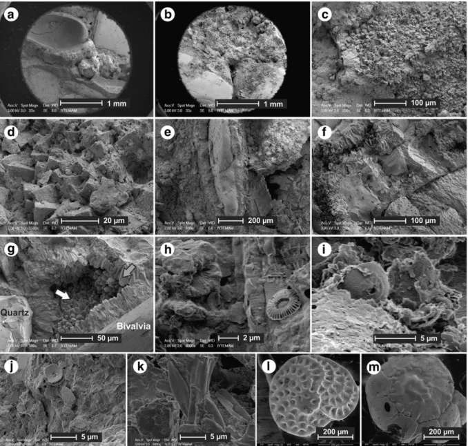
Cementation starts on grain and bioclast surfaces composed of micrite crystals with thin coatings up to 20μm thick (Fig. 5a, b, c
and d), suggestive of a marine phreatic conditions (Friedman, 1964). These mantles also embrace an edge of bivalve fragments standing ver-tically within thefine-grained hash matrix of the cemented material of the coquinite (Fig. 5e). The encircling micrite cement shows the rims composed of 50μm long equidimensional crystals of calcite (Fig. 5f). This second stage of cement suggests of pore-lining cement in meteoric phreatic environments (Flügel, 2010). This pattern of meteoric cementa-tion, characterized by bladed low-magnesian calcites, is also a diagnostic feature that distinguishes lithified beach deposits from beachrock sensu stricto (Spurgeon et al., 2003).
There is a third stage of cemented calcite consisting of equal-sized subhedral and anhedral crystals of calcite. Here the crystal sizes range between 5μm and 20 μm. This equant mosaic cement bounded by re-ciprocally oriented crystals appears asfills at the bottom of interparticle
Fig. 4. Resistivity tomograms from the coquina beach taken perpendicular to the coastline beach. The locations of the tomograms taken parallel to the coastline beach are shown on the top of the tomograms by black arrows. (Vertical exaggeration: 1.2 ×).
Table 1
EDX analyses results obtained from cement material of the coquinite. The units are wt.% for the elements.
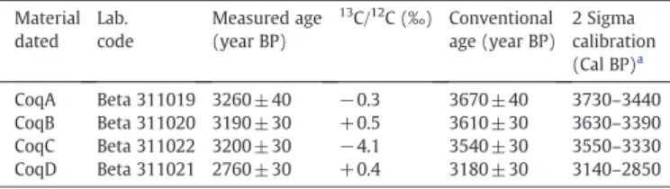
Elemental composition (wt.%) Sample C O Na Mg Al Si Cl K Ca Fe CoqA 12.8 41.2 1.7 2.1 10.1 18.8 0.8 2.2 5.7 4.5 CoqB 12.3 37.5 0.9 1.7 8.3 23.2 0.6 1.6 4.9 8.7 CoqC 19.3 35.0 1 0.8 1.1 3.8 0.2 0.6 33.8 4.4 CoqD 19.3 44.6 0.3 3 0 0.8 0 0 31.5 0 A and C: samples taken from 80 cm depth.
pores (Fig. 5g) due to percolation by meteoric waters. Its existence is in-dicative of a meteoric vadose environment (Tucker and Wright, 1990). SEM images demonstrate the existence of calcareous nannofossil coccoliths (Fig. 5h–i) and diatoms (Fig. 5k). The coccoliths are dominat-ed by Emiliania huxleyi and Reticulofenestra sessilis with diameters rang-ing between 5μm and 10 μm. Analyses from carbonates with cemented shell hash also indicated that the coquinite comprises various benthic foraminifera (Fig. 5l, m), such as Spiroplectinella wrightii, Spiroloculina excavata, Quinqueloculina sp., Triloculina sp., Polymorphina sp., Brizalina spathulata, Cassidulina crassa, Valvulineria minuta, Neoeponides bradyi, Rosalinafloridensis, Cibicides sp., Lobatula lobatula, Asterigerinata mamilla, Ammonia compacta, Ammonia tepida, Elphidium macellum, and Elphidium sp. These are Mediterranean migrant species that colonized the Black Sea after the connection between the Black and Mediterranean seas (Stanley and Blanpied, 1980) at ca 12,000 years BP (Çağatay et al., 2000). Based on distributional studies of benthic foraminifera, the genus Ammonia is dominant in the Holocene sediments of the Black Sea (Yanko, 1990; Ongan et al., 2009). Living benthic foraminifera are mainly distributed on the shelf area and the highest number of species are found near the Bosphorus strait (Yanko, 1990), due to proximity to a saline water
source. Benthic foraminiferal fauna is relatively diverse within the coquinite but the species are represented by a low number of speci-mens. In addition, different depth-related species are observed. Quinqueloculina, Triloculina, Ammonia and Elphidium genera character-ize water shallower than 50 m depth, whereas Brizalina, Cassidulina and Cibicides have a greater depth preference, up to bathyal (Murray, 1973). Considering the shell hash material, this benthic foraminiferal composition may be indicative of transportation and accumulation of organisms in the high-energy shelf environment.
4.3. Radiocarbon ages and implications for Late Holocene sea-level changes
Providing plenty of carbon for accurate measurement, four bulk samples of bivalves with fresh appearance collected from two differ-ent sites were dated using standard radiocarbon dating. For samples coqA and coqC extracted from 80 cm depth of cross-bedded laminae (Table 2), the two-sigma calibrated ages ranged between 3730 and 3550 years BP. The uppermost levels yielded a date range between 3630 and 3140 years BP.
Fig. 5. SEM images from inner parts of the coquinite samples. General view of micrite coatings on grain and bioclast surfaces (a, b); closer views of a and b (c, d); a vertical standing bivalvia fragment encircled by carbonate (e); closer examination of the encircling cement composed of rims of equidimensional calcite crystals (f); the equant mosaic cementfills at the bottom of inter particle pores (g); calcareous nannofossil coccoliths (h, i, j); diatoms (k), some species of benthic foraminifera (l, m).
Based on limit age values, our results reveal that the coquinite shells belong to a deposition period between 3730 and 2850 years BP (Table 2). These ages have implications concerning late Holocene sea-level dynamics of the Black Sea. It is possible to evaluate these ages by considering sea-level curves prepared for the northern Black Sea coast in the lack of any data from the Turkish coast which has a narrow shelf. Partly modified fromPirazzoli (1991)andMartin and Yanko-Hombach (2011),Fig. 6 shows the late Holocene sea-level curve for the eastern and northwestern Black Sea. As can be seen, there is a lack of harmony in the superimposed profiles in respect of both main trend and magnitude of oscillations for the last five millennia. Except forNevessky (1970)curve, the curves demonstrate notable oscillations below and above the present sea-level. According toMartin and Yanko-Hombach (2011)who studied this conflict, the difference in width and gradient of the Black Sea shelves, as well as the rate of sediment input and other local factors, could account for the substantial disagreement in the curves.
The main point that needs to be considered is that, during thefive millennia under question (Fig. 6), the level of the Black Sea has showed a trend to increase its level with the exception of a number of fluctuations due to alternating regressions and transgressions. When we put our ages onto these superimposed curves, the recent curves ofBalabanov (2007)andFilipova-Marinova (2007)appear to
be much more reasonable, showing lower-amplitude fluctuations
with good accordance in a general trend of alternating rise and falls. If we considerBalabanov's (2007)curve, the level of the Black Sea in-creased slightly from−70 cm to 0.Filipova-Marinova (2007) paleo-eustatic curve, which depends on calibrated ages obtained from materials of both shelf and deep-water zones of Bulgarian and backshore areas including lakes and river estuaries, indicates a drop
beach could be linked to meteoric cementation during dropped sea-level conditions. This decline may be linked to the Phanagorian
regres-sion (Tchepalyga, 1984; Martin and Yanko-Hombach, (2011) and
reached a peak at 2500 BP (Orachev, 1990). It can be assumed in the present case that the coquinite beds were deposited when the Black Sea was near to the level that it is today. The subsequent meteoric ce-mentation of shell debris occurred when the sea-level receded as far as about 2 m below the present level. The lower level of beds under the coquina beach being below the present sea-level suggests that a persistent rise up to the present occurred after cementation of the youngest beds.
5. Conclusions
Micro-fabrics, fossil contents, subsurface nature and radiocarbon dating of carbonate-cemented coquinite were studied at Karaburun on the Thracian coast of the Black Sea. Cemented by low magnesian calcite, the coquinite contains various transported bivalves, bentic fo-raminifera and coccoliths. Results reveal that deposition and ensuing cementation of the coquinite occurred in the last four millennia as the result of cementation in marine phreatic and meteoric phreatic/ vadose environments. Consecutive cement patterns from intertidal to supratidal are indicative of about a 2 m drop in sea-level during early phase (between 3730 and 2850 years BP) of the Phanagorian re-gression. However, the vertical extension of beds under the coquina beach may suggest older ages for the deeper-buried deeper part of the sequence. This study showed that a combined use of geological and geophysical data together with radiocarbon ages proved useful for better understanding such carbonate-cemented coastal deposits.
Fig. 6. Late Holocene sea-level curves for the eastern and northwestern Black Sea.
Partly modified fromPirazzoli (1991)andMartin and Yanko-Hombach (2011). Data fromNevessky, 1970, Ostrovsky et al., 1977, Voskoboinikov et al., 1982, Tchepalyga, 1984, Balabanov and Izmailov, 1988.
Acknowledgments
Dr. Aydın Büyüksaraç is thanked for allowing us to use the
resistivity-meter for this research. Thanks are also due to Mrs. Rezzan Ekinci for her great efforts during the data acquisition stage of the geoelectrical survey. We wish to thank Mr. Graham Lee for correction of English text. We are also indebted to the journal editor Dr. Jasper Knight, and the referees Dr. Ron Martin, Dr. Marcelo Manassero and an anonymous referee for their constructive comments that have greatly improved our paper. This study was supported by Research Foundation of Canakkale Onsekiz Mart University (project number: 2011/41).
References
Aksu, A.E., Hiscott, R.N., Mudie, P.J., Rochon, A., Kaminski, M.A., Abrajano, T., Yasar, D., 2002. Persistent Holocene outflow from the Black Sea to the Eastern Mediterranean contradicts Noah's Flood hypothesis. GSA Today 12, 4–10.
Andrusov, N.I., 1918. Geologicheskoe stroenie dna Kerchenskogo proliva [Geological structure of the bottom of the Kerch Strait]. Izvestiia Akademii Nauk SSSR 12, 23–28 (In Russian).
Balabanov, I.P., 2007. Holocene sea-level changes of the Black Sea. In: Yanko-Hombach, V., Gilbert, A.S., Panin, N., Dolukhanov, P. (Eds.), The Black Sea Flood Question: Changes in Coastline, Climate, and Human Settlement: Dordrecht. Springer, The Netherlands, pp. 711–730.
Balabanov, I.P., Izmailov, Ya.A., 1988. Changes in level and hydrochemical regime of the Black Sea and the Sea of Azov during the last 20 ka. Water Resources 15, 539–546 (In Russian).
Bekler, T., Ekinci, Y.L., Demirci, A., Erginal, A.E., Ertekin, C., 2011. Characterization of a landslide using seismic refraction, electrical resistivity and hydrometer methods, Adatepe-Çanakkale, NW Turkey. Journal of Environmental and Engineering Geophysics 16, 115–126.
Bissell, H.J., Chilingar, G.V., 1967. Classification of sedimentary carbonate rocks. In: Chilingar, G.V., Bissell, H.J., Fairbridge, R.W. (Eds.), Carbonate Rocks: Origin, Occur-rence and Classification: Developments in Sedimentology, 9A. Elsevier, New York, pp. 87–168.
Blagovolon, V.S., Scheglov, A.N., 1968. Fluctuations in Black Sea level in historical time, as indicated by archaeological–geomorphological studies in Southwestern Crimea. USSR Ser. Geol., 2, pp. 49–58.
Brückner, H., Kelterbaum, D., Marunchak, O., Porotov, A., Vött, A., 2010. The Holocene sea level story since 7500 BP—lessons from the Eastern Mediterranean, the Black and Azov Seas. Quaternary International 225, 160–179.
Çağatay, M.N., Görür, N., Algan, O., Eastoe, C., Tchapalyga, A., Ongan, D., Kuhn, T., Kuşcu, İ., 2000. Late Glacial-Holocene palaeoceanography of the Sea of Marmara: timing of connections with the Mediterranean and Black seas. Marine Geology 167, 191–206.
Chowdhury, S.Q., Fazlul, A.T.M., Hasan, H.K., 1997. Beachrock in St. Martin's Island, Bangladesh: implications of sea level changes on beachrock cementation. Marine Ge-odesy 20, 89–104.
Ekinci, Y.L., Kaya, M.A., 2007. 3D resistivity imaging of buried tombs at the Parion Ne-cropolis (NW Turkey). Journal of the Balkan Geophysical Society 10, 1–8. Filipova-Marinova, M., 2007. Archaeological and paleontological evidence of climate
dynamics, sea-level change, and coastline migration in the Bulgarian sector of the circum-Pontic region. In: Yanko-Hombach, V., Gilbert, A.S., Panin, N., Dolukhanov, P. (Eds.), The Black Sea Flood Question: Changes in Coastline, Climate, and Human Settlement: Dordrecht. Springer, The Netherlands, pp. 453–481. Flügel, E., 2010. Microfacies of carbonate rocks: analysis. Interpretation and Application.
Springer, p. 984.
Friedman, G.M., 1964. Early diagenesis and lithification in carbonate sediments. Journal of Sedimentary Petrology 34, 777–813.
Göktürkler, G., Balkaya, Ç., Erhan, Z., Yurdakul, A., 2008. Investigation of a shallow alluvial aquifer using geoelectrical methods: a case from Turkey. Environmental Geology 54, 1283–1290.
Goudie, A.S., 2001. The Nature of the Environment, 4th edition. Wiley-Blackwell, p. 560. Knox, G.J., 1977. Caliche profile formation. Saldanha Bay (South Africa). Sedimentology
24, 657–674.
Le Blanc, R.J., Breeding, R.G., 1957. Regional aspects of carbonate deposition, a symposium: Soc. Econ. Paleontologists and Mineralogists Special Publications, 5, pp. 1–178. Loke, M.H., Barker, R.D., 1996. Rapid least-squares inversion of apparent resistivity
pseudosections using a quasi-Newton method. Geophysical Prospecting 44, 131–152. Martin, R.E., Yanko-Hombach, V., 2011. Rapid Holocene sea-level and climate change in the Black Sea: an evaluation of the Balabanov sea-level curve. In: Buynevich, I.V., Yanko-Hombach, V., Gilbert, A.S., Martin, R.E. (Eds.), Geological Society of America Special Paper, 473, pp. 51–58.
Murray, J.W., 1973. Distribution and Ecology of Living Benthic Foraminiferids. Heineman, London. pp. 288.
Nevessky, E.N., 1970. Holocene history of the coastal shelf zone of the USSR in relation with processes of sedimentation and condition of concentration of useful minerals. Quaternaria 12, 78–88.
Oktay, F.Y., Eren, R.H., Sakınç, M., 1992. Karaburun-Yeniköy (İstanbul) çevresinde Doğu Trakya Oligosen Havzasının sedimenter jeolojisi: Türkiye 9. Petrol Kongresi bidirileri. Ankara 92–101 (in Turkish).
Ongan, D., Algan, O., Kapan-Yeşilyurt, S., Nazik, A., Ergin, M., Eastoe, C., 2009. Benthic faunal assemblages of the Holocene sediments from the Southwest Black Sea shelf. Turkish Journal of Earth Sciences 19, 239–297.
Orachev, A., 1990. Prinosi kam paleografiata na Dobrudzhanskoto kraibrejie (Contributions to the palaeogeography of the Dobrıja coastal zone). Dobrudzha 7, 32–49 (in Bulgarian).
Ostrovsky, A.B., Izmaylov, Y.A., Balabanov, I.P., Skiba, S.I., Skryabina, N.G., Arslanov, S.A., Gey, N.A., Suprunova, N.I., 1977. Novie dannie opalegidrologicheskom rezhime Chernogo moria v verkhnem pleistotsenei golotsene (New data on the paleo-hydrological regime of the Black Sea in the Upper Pleistocene and Holocene). In: Kaplin, P.A., Shcherbakov, F.A. (Eds.), Paleogeografi ia i otlozheniia pleistotsena iuzhnykh morei SSSR: Moscow. (Pleistocene Paleogeography and Sediments of the Southern Seas of the USSR). Nauka, Moscow, pp. 131–140 (in Russian). Pirazzoli, P.A., 1991. World Atlas of Holocene Sea-Level Changes: Amsterdam. Elsevier,
The Netherlands, p. 300.
Reimer, P.J., Baillie, M.G.L., Bard, E., Bayliss, A., Beck, J.W., Blackwell, P.G., Bronk Ramsey, C., Buck, C.E., Burr, G.S., Edwards, R.L., Friedrich, M., Grootes, P.M., Guilderson, T.P., Hajdas, I., Heaton, T.J., Hogg, A.G., Hughen, K.A., Kaiser, K.F., Kromer, B., McCormac, F.G., Manning, S.W., Reimer, R.W., Richards, D.A., Southon, J.R., Talamo, S., Turney, C.S.M., van der Plicht, J., Weyhenmeyer, C.E., 2009. IntCal09 and Marine09 radiocarbon age calibration curves, 0–50,000 years cal BP. Radiocarbon 51 (4), 1111–1150.
Rucker, D.F., Loke, M.H., Noonan, G.E., Levitt, M.T., 2010. Electrical resistivity characterization of an industrial site using long electrodes. Geophysics 75, WA95–WA104.
Rupert, F.R., 1989. Guide to Geologic and Paleontologic Sites in Florida: Florida Geolog-ical Survey Map Series, 125.
Ryan, W.B.F., Pitman, W.C., Major, C.O., Shimkus, K., Moskalenko, V., Jones, G.A., Dimitrov, P., Görür, N., Sakınç, M., Yüce, H., 1997. An abrupt drowning of the Black Sea shelf. Marine Geology 138, 119–126.
Sakınç, M., 1994. Karaburun (B Istanbul) denizel Oligoseninin stratigrafisi ve paleontolojisi. MTA Dergisi 116, 9–14 (in Turkish).
Sasaki, Y., 1992. Resolution of resistivity tomography inferred from numerical simula-tion. Geophysical Prospecting 40, 453–464.
Spurgeon, D., Davis J.R., R.A., Shinnu, E.A., 2003. Formation of‘Beach Rock’ at Siesta Key, Florida and its influence on barrier island development. Marine Geology 200, 19–29.
Stanley, D.C., Blanpied, C., 1980. Late Quaternary water exchange between the eastern Mediterranean and the Black Sea. Nature 266, 537–541.
Stuiver, M., Reimer, P.J., 1993. Extended14C data base and revised CALIB 3.014C age
calibration program. Radiocarbon 35, 215–230.
Sun, J., Xu, H., Qui, X., Zhan, W., Li, Y., 2009. Diagenesis and evolution of the Holocene coquinite from the Haishan Island, Eastern Guangdong, China. Acta Geologica Sinica 83, 70–80.
Tchepalyga, A.L., 1984. Inland sea basins. In: Velichko, A.A., Wright, H.E.J., Barnosky, C.W. (Eds.), Late Quaternary Environments of the Soviet Union: Minneapolis. University of Minnesota Press, Minnesota, pp. 229–247.
Tucker, M.E., Wright, V.P., 1990. Carbonate Sedimentology. Blackwell Scientific Publications, Oxford, p. 496.
Türkeş, M., 1996. Spatial and temporal analysis of annual rainfall variations in Turkey. International Journal of Climatology 16, 1057–1076.
Türkeş, M., 2000. Climate change studies and activities in Turkey. Participant's Presen-tations for the Advanced Seminar on: Climatic Change: Effects on Agriculture in the Mediterranean Region. Mediterranean Agronomic Institute of Zaragoza, pp. 25–29 (September).
Türkeş, M., 2003. Spatial and temporal variations in precipitation and aridity index series of Turkey. In: Bolle, H.J. (Ed.), Mediterranean Climate— Variability and Trends. Regional Climate Studies. Springer Verlag, Heidelberg, pp. 181–213. Türkeş, M., 2010. Climatology and meteorology. Publication No. 63 First edition. Physical
Geography Series No. 1. Kriter Publisher,İstanbul (in Turkish). ISBN: 978-605-5863-39-6, 650 + XXII pp.
Turoğlu, H., Cürebal, İ., 2005. Karaburun (İstanbul) and Uluabat (Bursa) beachrocks. Geographical Journal ofİstanbul University 13, 57–66 (in Turkish with English abstract).
Voskoboinikov, V.M., Rotar, M.F., Konikov, E.G., 1982. Sviaz' ritmichnosti stroeniia tolshch golotsenovykh otlozhenii Prichernomorskikh limanov s kolebatel'nym rezhimom urovnia Chernogo moria [Relationship between the rhythmic composi-tion of thick Holocene layers of the Black Sea region lagoons and the oscillatory level regime of the Black Sea]. In: Kaplin, P.A., Klige, R.K., Chepalyga, A.L. (Eds.), Izmeneniia urovnia moria [Sea-Level Fluctuations]. Moscow State University, Moscow, pp. 264–274 (in Russian).
Wilson, J.L., 1975. Carbonate Facies in Geologic History. Springer-Verlag, Berlin, p. 65. Yanko, V., 1990. Stratigraphy and paleogeography of the marine Pleistocene and
Holo-cene deposits of the southern seas of the USSR: Memorie della Societa Geologica Italiana, 44, pp. 167–187.
Yanko-Hombach, V.V., 2007. Controversy over Noah's Flood in the Black Sea: geological and foraminiferal evidence from the shelf. In: Yanko-Hombach, V., Gilbert, A.S., Panin, N., Dolukhanov, P. (Eds.), The Black Sea Flood Question: Changes in Coastline, Climate, and Human Settlement. Springer, Dordrecht, The Netherlands, pp. 149–204.