PHYSICAL ENVIRONMENT AND SETTLEMENT PATTERN IN DELIORMAN REGION (N.E. BULGARIA) IN THE
SIXTEENTH CENTURY
The Graduate School of Economics and Social Sciences of
İhsan Doğramacı Bilkent University
by
AYŞEGÜL YAĞ
In Partial Fulfillment of the Requirements for the Degree of MASTER OF ARTS
DEPARTMENT OF HISTORY
İHSAN DOĞRAMACI BİLKENT ÜNİVERSİTESİ ANKARA
ABSTRACT
PHYSICAL ENVIRONMENT AND SETTLEMENT PATTERNS IN DELIORMAN REGION (N.E. BULGARIA) IN THE SIXTEENTH CENTURY
Yağ, Ayşegül
M.A, Department of History
Supervisor: Asst. Prof. Evgeniy Radoslavov Radushev
May 2018
The spreading process of the Ottoman Empire in the Balkan region covers a very long period. After the successive conquest period, the ultimate goal of the institutionalization was to maintain the permanence in the region. To accomplish this, they practiced military and political methods. One of the most important of these was the establishment of new settlements representing the Ottoman presence. In the context of this study, the nature of these new settlements formed in the Deliorman region in the 16th century will be examined on the basis of the villages. Also, the role of geographical factors will be emphasized in these settlements. The demographic changes over time will be revealed via tahrir defters (tax registers) dated 1530, 1573 and 1580. The geographical factors will be used as the basis for the comparisons between these three defters. For this reason, 11 villages have been chosen to make an analysis about the process of infiltration of the nomadic groups into the sedentary life.
Keywords: Deliorman, Nomadism, Ottoman Empire, Physical Environment, Sedentarization.
ÖZET
16.YÜZYIL DELİORMANI’NDA (KUZEYBATI BULGARİSTAN) FİZİKİ ÇEVRE VE YERLEŞİM MODELLERİ
Yağ, Ayşegül
Yüksek Lisans, Tarih Bölümü
Tez Danışmanı: Dr. Öğr. Üyesi Evgeniy Radoslavov Radushev Mayıs, 2018
Osmanlı’nın Balkan coğrafyasında yayılma süreci çok uzun bir dönemi kapsamaktadır. Başarılı bir fetih sürecinden sonra gelen kurumsallaşma sonucu, Osmanlı’nın nihai hedefi bölgede kalıcılığa ulaşabilmek olmuştur. Bunu başarmak için askeri ve politik olmak üzere çeşitli yöntemler uygulamıştır. Bunların arasında en önemli olanlardan biri de Osmanlı varlığını temsil eden yeni yerleşim yerlerinin kurulması olmuştur. Bu çalışma bağlamında 16.yüzyılda Deliorman bölgesinde oluşan yeni yerleşimlerin doğasını köyleri temel alarak incelenecek ve bu yerleşimlerde coğrafi etkenlerin rolüne ağırlık verilecektir. Bu amaç doğrultusunda, 1530, 1573 ve 1580 tarihli tahrir defterleri kullanılarak zaman içerisindeki demografik değişimler ortaya konulacaktır. Bu üç defter arasında yapılacak karşılaştırmalarda coğrafi etkenler temel alınacaktır. Ayrıca, bu bölgeden seçilen 11 köy ile, göçebe grupların yerleşik hayata dahil olma süreci hakkında bir analiz yapmak amaçlanmaktadır. Anahtar Kelimeler: Deliorman, Fiziki Çevre, Göçebelik, Osmanlı İmparatorluğu Yerleşiklik.
ACKNOWLEDGEMENTS
First of all, I am very grateful to my advisor Prof. Evgeniy Radushev for his precious direction during the process of the accomplishment of this thesis. His supervision and comments gave me a versatile point of view while composing this work. Also, with his encouragement and support, my passion towards the Ottoman world increased.
I would like to thank Prof. Özer Ergenç and Prof. Mehmet Seyitdanlıoğlu for their enlightening comments and critiques as jury members. Especially, I am obliged to Prof. Ergenç for his improvement of my skill to be able to read the Ottoman Paleography and Ottoman Diplomatics with his lectures, as moments of pleasure to me. Also, Dr. Özel shared his valuable opinions leading me to draw attention to the right points before starting to write this thesis.
I am indebted to Aslıhan Aksoy Sheridan, Abdurrahim Özer and Öykü Terzioğlu for their guidance since my first day at Bilkent University. I owed my friends Sinem Serin, Kaan Alptekin Gençtürk, Dürdane Öcal, Nihal Kıran, Nazlı Güzin Özdil, MHatice Mete and Dilara Avcı so much because of their full support and sincere motivations in my tough and desperate times. Last but not least, I am eternally grateful to Nimet Kaya (RIP) for her emotional support until her last day.
TABLE OF CONTENTS ABSTRACT………... ii ÖZET………..iii ACKNOWLEDGMENTS………... ……….iv TABLE OF CONTENTS………...v LIST OF TABLES………..………...vii LIST OF FIGURES………...viii CHAPTER ONE:INTRODUCTION………1 1.1 Objectives………2
1.2 Sources and Methodology………...4
CHAPTER TWO: CONQUEST AND AFTERMATH...10
CHAPTER THREE: PEOPLE AND ENVIRONMENTAL SPACE IN DELIORMAN REGION………..27
3.1 People, history and geography………28
3.1.1. Water ……….…………...29
3.1.2. Soil ………...32
3.1.3.Climate ……….35
3.1.4 Mountains ……….….38
3.2. The Natural Challenge and the Response of the Societies………..43
3.2.1 The impact of environmental conditions on human development………43
CHAPTER FOUR: OTTOMAN SETTLEMENT IN DELIORMAN
REGION………52 4.1.Settlement in the rural region of Deliorman the Ottoman Rule: Continuity and Change...52 4.2. The Nomads of the Empire: The Yürük Community and Their
Organization………...57 4.3. The existence of yürük groups in the villages of the Deliorman
Region……….61 4.4 The Sedentarization of the Yürüks ………..62
4.4.1 The interactions of the yürük groups with the surrounding
world...……… ...62 4.4.2 The reflection of sedentarization in the tax registers…...64 4.5. The condition accelerating the process of the sedentarization among the
yürük groups……….……..67
4.5.1 The incentives provided by the state………...67 4.5.2 The role of the Dervishes ……….…….69 5. The final move: The Abolition of the Yürük Organization………….…………...70 CHAPTER FIVE: CONCLUSION………...75 BIBLIOGRAPHY……….…...79 APPENDICES………...91
LIST OF TABLES
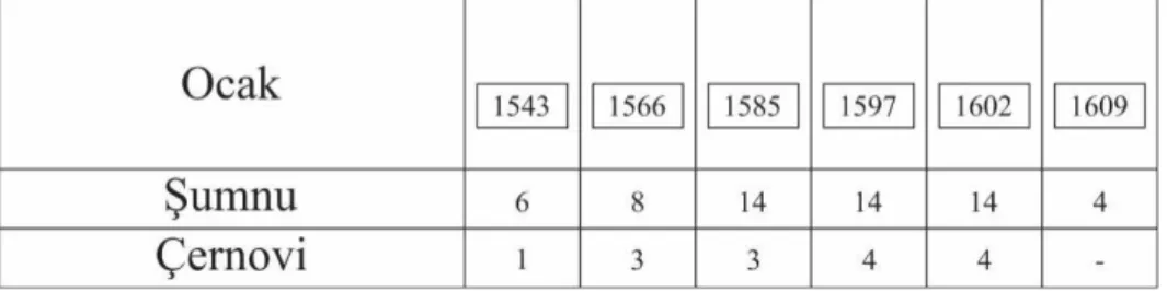
TABLE 1. The Population of Naldöken Yürüks in Şumnu and Çernovi...65
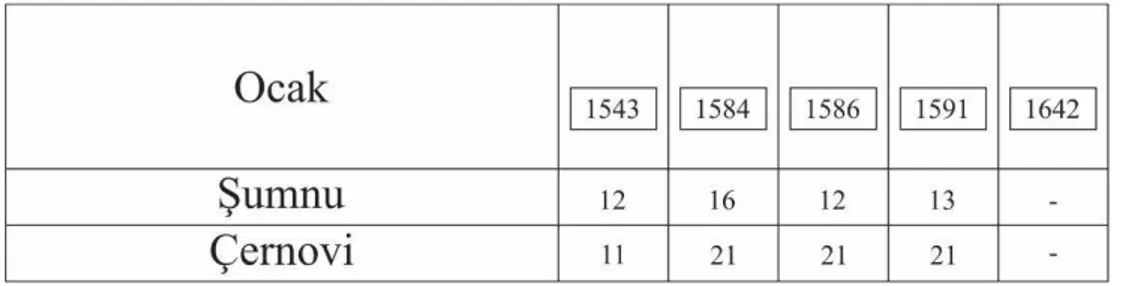
TABLE 2. The Population of Tanrıdağı Yürüks in Şumnu and Çernovi...66
LIST OF FIGURES
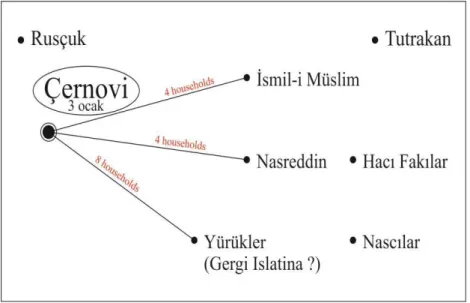
FIGURE 1. The Sedentarization of the Yürüks in Çernovi...68
CHAPTER ONE
INTRODUCTION
Since the earliest times people have had to survive in nature; foremostly, mankind has always needed to find suitable environments in which his basic needs can be met. Maslow's hierarchy of needs is a helpful theory about the nature of these requirements. On the first level of his pyramid visualizing this hierarchy are the physiological needs of hunger, thirst, and other essential requirements. On the second level, the need for security becomes apparent. These two steps actually manifest themselves in the dynamics of settlement. After these two needs have been satisfied, people can begin to create the cultures that then become the basis of human civilizations. In the course of this development, groups were separated according to their socio-economic activities and two main groups emerged: nomads and settlers.
Both of these groups have an organized structure, but these different structures do not prevent them from communicating with each other. It should also be noted that neither group is able to isolate itself from the outside world. In addition, centralized
states prefer to encourage nomadic groups to live a more settled life. Empires have difficulty in controlling nomadic groups because these groups do not want to be registered to any particular location thanks to their mobile lifestyle. On this point, states have had to act very tactfully in order to not create or exacerbate tension between already settled locals and nomadic newcomers. For this reason, there were two option for states seeking to settle nomads in a region. Either they would choose to kill the local groups to refill the area with their own people or they would develop institutions providing the necessary balance among these groups.
1.1 Objectives
The subject to be examined in this thesis is the motivations behind the settlement of the Ottoman Empire in Deliorman region (mod.Ludogorie) of modern-day Bulgaria. There are a number of reasons why the Deliorman area has specifically been selected. First of all, this region has been one of the main migration routes of nomadic groups since antiquity. Passes through the Carpathian Mountains served as gateways for nomadic groups seeking new lands in the Northeastern Balkans. Aside from the Carpathians, the Danube River is a geographical formation that offers groups migrating from the steppe another route to settlement in the south. It is recorded that there were some migrations to the Deliorman region via the Danube. For example, the first move to this region was under Zabergan, leader of the Bulgarians of Kuturgh in 558 AD. Since the Danube was frozen in that time, this group could easily cross it. Though dates and names can vary, the immutable nature of the geographical formations here molds and shapes the flow of history.
Throughout its settlement history, the Deliorman region has become a geographical area where various groups have passed in different periods.1Groups used it as a settlement point during migratory movements because it was rich in natural resources like water and arable lands. Hence, it is not surprising that various great states were also interested in this region. The Ottomans were one of these states and their influence in this region established an order whose repercussions are still felt today in some respects. Thanks to the balance which they established both socially and economically, their presence in the region lasted for centuries. They were able to establish permanent settlements in line with their original aims.
The geography of the Balkan peninsula has witnessed a turbulent historical past and the prominent position of the Ottomans in this dynamic past cannot be denied. Some Balkanists, however, influenced by nationalist ideologies in the Communist era, argued that the Ottoman presence created traumatic effects in the region. In this respect, the first problem to be examined in this study is the methods that the Ottoman Empire practiced during its settlement process. Academic circles with extreme views such as Gandev have preferred to examine the whole of these methods under the title of catastrophic theory. It has even been argued, with some unfounded calculations, that the Ottoman presence was strengthened by the killing of the local people in the region. However, the actual situation reflected in the chronicles is quite different from the result suggested by nationalist historiography. Here, as demonstrated in İnalcık's works, it can be understood that the key point in Ottoman settlement was diplomacy. Fighting with the local groups remained only as the last resort. So the first aim in this
work is to examine the political and military dimensions of the Ottoman settlement in Bulgaria and even more specifically in Deliorman region.
Secondly, it will also be very useful to examine the influence of geographical forms on human life, and thus on settlement, in the context of this work. Analyzing the Deliorman region is necessary to understand the geography where the Ottomans settled. One of the main methods carried out by the Ottomans was to enrich the newly conquered lands with manpower through migrations to appropriate places. As the Ottoman economic structure was heavily based on agriculture, determining the geographic features related to cultivation was crucial in allowing them to create a reasonable taxation system. With its similar landscape to the Anatolian plateau, the Deliorman region became one of the top preferences for groups migrating from Anatolia to the Balkans thanks to its fertile lands. This situation can be also interpreted as an advantage presented by geography for the Ottomans in terms of socio-economic issues.
Under Ottoman rule, it is possible to observe the emergence of some specific settlement patterns. As I have mentioned above, such patterns were created by both settlers and nomads. For the Ottomans, preserving the balance between these two groups was a prerequisite for strengthening their existence in the region. As a result of this, there is no strict difference between settled Muslims and settled non-Muslims in terms of socio-economical status. Yet the main problem was that the nomads, called
yürük, had a mobile life which prevented the Ottomans from registering them as the
taxpayers. To get rid of this limitation, the Ottomans chose to sedentarize these groups. Thus, while analyzing the Ottoman settlement pattern in this region, our main focus will be the yürüks that were a bit different from ordinary social milieu. Accordingly
the third objective of this thesis is shaped around the analysis of the process of sedentarization of these yürük groups in the aforementioned region.
In short, this study tries to examine the Ottoman settlement in Deliorman region after a successful conquest period. In this thesis, the impact of the geographic features on the flow of the history will emerge.
1.2 Sources and Methodology
The primary sources used in this thesis are composed of tax registers known as
defters.2It is necessary to mention the content of these registers before passing to their function for this research. In the Ottoman Empire, defters were a type of record used to determine the number of taxable citizens by an agent of the corporate state structure.3In these registers, one can find information regarding the administrative unit in which the persons were registered, how much tax they would pay, and their socio-economic status. They were divided into two types, mufassal (detailed tax registers) and icmal (synoptic tax registers).
Mufassal defters contain the detailed information about the region and its
residents. At first glance, the names of people or villages in the lists help to identify the religious status of groups such as Muslims and non-Muslims. For this research, the
2In this thesis, the defters, TKGM TD 0042, TKGM, TT 0357 and 370 numaralı muhâsebe-i vilâyet-i rûm-ili defteri will be used.
3See Halil İnalcık, Hicrî 835 Tarihli Sûret-i Defter-i Arvanid (Ankara: TTK,1987). ; Barkan “ Tarihi Demografi Araştırmaları ve Osmanli Tarihi” Türkiyat Mecmuası 10 (1951-1953): 1-26; Barkan, “Research on the Otoman Fiscal Surveys “, in M.A. Cook (ed.), Studies in the Economic History of the Middle East (London, 1970); Heath, W. Lowry, Ottoman Tahrir Defteri As a Source for Social and Economic History: Pitfalls and Limitations in Heath W. Lowry, Studies in Defterology: Ottoman Society in the Fifteenth and Sixteenth Centuries (Istanbul; Isis Press 1992); Mehmet Öz, “Tahrir Defterlerinin Osmanlı Araştırmalarında Kullanılması Hakkında Bazı Görüşler”, Vakıflar Dergisi, 12 (1991): 229-239; Kemal Çiçek, “Osmanlı tahrir Defterlerinin Kullanımında Görülen Bazı Problemler ve Method Arayışları”, Türk Dünyası Araştırmaları 97 (1995).; Machiel Kiel, “Remarks on the administration of the poll tax (Cizye) in the Ottoman Balkans," Second International Seminar for Otto-man Palaeography, Sofia, Sept.-Oct. 1988, in: Etudes Bal-kaniques No 4, Sofia, 1990, p. 70-104.
salient feature of these records is that they render an idea on the variety of production and the boundaries of the administrative units. While the number of items under production is reduced in more mountainous regions, the diversity of production in the regions with more temperate climates displays an increase. By this means, it is possible to have knowledge about the geographical structure of a given region. In addition to the geographical deductions, one is also able to express an opinion whether the people of a given area is permanently settled or nomadic. For example, in areas where nomadic groups have lived, cultivation is heavily dependent on the basic crops for them and their animals such as wheat, oats, or barley. On the other hand, places having vineyards or gardens are inhabited by permanent residents, not nomads. The reason of this is that these products are constantly in need of maintenance and do not fit with the lifestyle of nomadic groups.
In this work, these records will not be used to reach some numeric results in terms of taxation. They are not just piles of records suggesting the direction of the economic activity of the society but rather also have precious data which can allow a researcher to observe some processes related to the settlements of different groups. Within the frame of this thesis, defters including the yürüks will be utilized. For the Ottomans, it is essential to determine the number of the nomads in their borders. As much as possible, they could achieve to record these mobile people into the defters as nomads. Also, the state tried to regulate their life with some codifications according to their region.
In the context of this thesis, there are two different reasons for choosing these three types of defters. The first one is to examine the role of geographical forms in forming a certain pattern of settlement and to analyze what human behavior is in areas where geographical forms occasionally form a natural obstacle. Secondly, through
some comparisons between years, I hope to demonstrate the process of transition of the nomadic groups in Deliorman region to sedentary life.
The secondary sources that have been used is the work generally reveal the effects of geographical forms on human beings and their consequences. Therefore, this area, which has been studied under the title of human geography4, has come into the present day with various factions. The oldest of these is the viewpoint of environmental determinism5. It dates back to antiquity and argues that people are helpless in the face of geographical forms and that their behaviours are shaped by purely geographical conditions. Among the pioneers were Hippocrates and Ibn Khaldun. Another approach following environmental determinism is possibilism. In fact, possibilism argues for a traditional approach to environmental determinism as opposed to an opinion. This movement, pioneered by la Blache, asserts that geographical forms are sometimes an effective element, but that culture is actually the result of social conditions. In other words, geography is not always an obstacle that determines or restricts people's movements. On the contrary, there is an ongoing dialogue between groups and natural conditions. The advantages of nature for different groups living in different geographies at the points where this dialogue is carried out in good health have always been the subject of discussion.
4For this term, see also William Norton, Human Geography, Oxford UP, 1992; Kevin Cox, Making Human Geography, The Guilford Press, 2014; Derek Gregory, Horizons in Human Geography, Macmillan, 1951; Human geography : landscapes of human activities, Macmillan, 1994; Mark Boyle, Human Geography: A concise Introduction, John Wiley&Sons, 2014; Edward Bergman,
Human geography : cultures, connections, and landscapes, Prentice Hall, 1995; Jerome D. Fellmann, Human geography : landscapes of human activities, W.C. Brown, 1990; Terry G. Jordan Bychkov, The human mosaic : a thematic introduction to cultural geography, Longman, 1994.
5For the writers suggesting this approach see Ellen Churchhill Semple, Influences of Geographic
Environment, on the Basis of Ratzel's System of Anthropo-Geography. New York: H. Holt & Co,
1911; Humboldt, Kosmos: Entwurf Einer Physischen Weltbeschreibung, Die Andere Biblioteke, 1845; Carl Ritter, Einleitung zur allgemeinen vergleichenden Geographie, und Abhandlungen zur
Yet another view is the Challenge-Response theory as presented by Toynbee. The core idea of this theory is that man is not totally helpless against nature. In fact, he argues that the difficulties that nature presents to mankind actually constitute the material for the advancement of civilization. Every difficulty that is overcome leads mankind to take a step further and to make civilization grow. Thus once again the dominion of geography on the course of human beings.
While we have sometimes overlooked these views in this study, the method that has been used when the primary sources were examined was the Annales School which emphasizes the relationship between history and geography.6 Figures like Bloch, Febvre, Braudel, and Le Goff, gathered around the journal Annales d'histoire
économique et sociale, were the pioneers of this approach. What distinguishes them
from other movements was their new interpretation of history in the 19th century. According to them, history is just not an expression of continuous and sequential events but a field that requires a wider time frame they termed the longue durée. In order for these activities to be well understood, they argued that other branches of study -geography, sociology, and archeology- should be utilized.7 In this context, Braudel's The Mediterranean and the Mediterranean World in the Age of Philip II has
6For detailed information on the keypoints of the approach of historical geography, see Michael Pacione, Historical Geography: progress and prospect, Cambridge UP, 1994; Alan Baker, Geography and History: Bridging the Divide, Cambridge UP, 2003; Robin Butlin, Historical Geography: through the gates of space and time, London ; New York : Edward Arnold, 1993; John Morrissey, Key concepts in Historical Geography, Sage, 2014; On specific region analysis see also Francis Carter, An Historical Geography of the Balkans, Academic Pr., 1977; Henry Clifford Darby, A New Historical Geography of England, Cambrigde UP, 1973; Sir William Mitchell Ramsay, The Historical Geography of Asia Minor, Cooper Square, 1972; Wolf-Dieter Hütteroth and Kamal Abdulfattah,
Historical geography of Palestine, Transjordan and Southern Syria in the late 16th [sixteenth] century, Erlangen: Erlanger Geographische Arbeiten, 1977.
7For more information on the development of the Annales school, see Peter Burke, The French
Historical Revolution: The Annales School, 1929-1989, Stanford University Press. 1991; François
Dosse. The New History in France: The Triumph of the Annales. University of Illinois Press. 1994; Lynn Hunt and Jacques Revel (eds). Histories: French Constructions of the Past. The New Press. 1994.
been quite useful for this research. In addition, Febvre's book Geographical Introduction to History has been used.8
8For the works by the authors from the Annales School, see also Bloch, Marc. Feudal Society: Vol 1:
The Growth of Ties of Dependence (1939); Bloch, Marc. Méthodologie Historique (1988); Bloch,
Marc. French Rural History: An Essay on Its Basic Characteristics (1931), trans. Janet Sondheimer (London: Routledge & Kegan Paul, 1966); Bloch, The Historian's Craft: Reflections on the Nature
and Uses of History and the Techniques and Methods of Those Who Write It, Vintage, 1964; Lucian
Febvre, A Geographical Introduction to History (A History of Civilization), Barnel&Noble, 1966; Lucian Febvre, Henri-Jean Martin, The Coming of the Book: The Impact of Printing 1450-1800, Verso, 1997;, Lucien Febvre, The Problem of Unbelief in the Sixteenth Century: The Religion of
Rabelais, Harvard University Press, 1982; Lucien Febvre, A New Kind of History: From the Writings of Lucien Febvre, Routledge and Kegan Paul, 1973.; Lucien Febvre, Life in Reneissance France,
Harvard UP, 1979; Fernand Braudel, The Mediterranean and the Mediterranean World in the Age of
Philip II, trans. Slan Reynolds, University of California Press, 1949; Civilization and Capitalism 15th-18th Century, Vol. 1: The Structures of Everyday Life, trans. Slan Reynolds, University of California
Press, 1992; Civilization and Capitalism 15th-18th Century, Vol 2: The Wheels of Commerce, trans. Slan Reynolds, University of California Press, 1979; A History of Civilisations, trans. Richard Mayne, Penguin, 1995; Memory and the Mediterranean, Vintage, 2002; Afterthoughts on Material
Civilization and Capitalism, trans. Patricia Ranum, John Hopkins UP, 1979; On History, University of
California Press, 1982; The Mediterranean in the Ancient World, Penguin, 2002; Jacques Le Goff,
Time, Work, and Culture in the Middle Ages, trans. Arthur Goodhammer, University of California
Press, 1982; History and Memory, California UP, 1996; Your Money or Your Life: Economy and
Religion in the Middle Ages, trans. Patricia Ranum, Zone Books, 1990; The Medieval Imagination,
trans. Arthur Goodhammer, University of California Press, 1992; The Birth of Europe, trans. Janet Lloyd, Blackwell, 2007; Medieval Civilization 400-1500, trans. Julia Barrow, Wiley-Blackwell, 1991; Intellectuals in the Middle Ages, Wiley-Wiley-Blackwell, 1993; The Birth of Purgatory, University of California Press, 1986.
CHAPTER TWO
CONQUEST AND AFTERMATH
Throughout history, as states have waxed and waned, some have devastated all the social, cultural and economic elements in the land they conquered while widening their borders, while others have instead tried to protect these as their sources of revenue. At the end, those who had well-developed policies would achieve the formation of a stable state organization. In this group we can include the Ottomans, who emerged on the stage of history as a small polity in western Anatolia, and chose to pursue the preservative policy towards already existing mechanisms in the regions they subjugated.
The Ottomans did not close the door on the world around them, a world in which they had to deal with political, geographical and even climatic issues. They were conscious of these problems and used them to turn situations to their own favor. This small principality, which avoided unnecessary conflicts exceeding their power, took Tzimpe Castle in accordance with a treaty signed between Orhan Bey and the Byzantine Emperor John VI Cantacuzenus. In the course of time, the Europeans accused the Byzantines of not standing against the Ottomans. Some years later, an
earthquake in Gallipoli helped the Ottomans progress toward the Balkan peninsula as the starting point of the conquests in Europe.9 Now the wind was blowing from the western part of Anatolia. This settlement would be the basic objective of the Balkan conquest, which lasted nearly 200 years. Here then, is the main question: what changed and what remained the same under the Ottoman Empire? As an answer to this question, the methods that the Ottomans applied during the conquest turn out to be an important issue waiting to be addressed step by step.
Vassalage was one of the main forms taken for the relations between the Ottomans and the other states. Making use of this type of relationship, the Ottomans established diplomacy as the basis of their way of in the region rather than strictly preferring the sword. Through the contacts between the Ottomans and their vassals, future conquests would thus become easier. For this reason successive huge battles were not seen in the region. In this way the Ottomans entered the context of the European world and they became an inseparable part of the European system.10
The Ottomans proposed a more functional vassal-suzerain relationship for the involved parties. The advantage of such an association was great for both sides. The vassal state continued to function in return for certain taxes and military support when the Ottomans required it. Besides, these contacts would give them the knowledge and perspective needed to understand the local dynamics of the region in terms of its geography and economy. Accordingly, the conquests were prolonged for many years.
9Inalcık, The Ottoman Empire: The Classical Age 1300-1600, p.13; Zachariadou, “Notes on the Subaşıs and the Early Sancakbeyis of Gelibolu”, The Kapudan Pasha: His Office and His Domain, ed. E.A.Zachariadou, Rethymnon: Crete UP,2002.; Hammer, Osmanlı İmparatorluğu Tarihi, p.177.; Beldiceanu, “Başlangıçlar: Osman ve Orhan, Osmanlı İmparatorluğu Tarihi I, p.29; Umar, Türkiye Halkının Ortaçağ Tarihi: Türkiye Türklerinin Ulusunun Oluşması, İstanbul, 1998.; McCarthy, The Ottoman Turks, p.33-62.; Kiel, “The Incorporation of the Balkans into the Ottoman Empire”, The Cambridge History of Turkey, p.138-191.; Goffman, The Ottoman Empire and Early Modern Europe, Cambridge UP, 2002.
10Fine, The Late Medieval Balkans: A Critical Survey from the Late Twelfth Century to the Ottoman
Some authors have suggested that the Ottoman success in the Balkans was based on the scattered situation of their rivals.11As Fine states:
“The first point to emphasize is the weakness of the Ottomans’ opponents. The Byzantine Empire was no longer an empire and after Dusan’s death neither was Serbia. And we have traced the territorial fragmentation of Serbia, Bulgaria and the Greek lands. As a result these regions became split into a number of petty principalities in the hands of nobles who fought for their own independence and expansion. Not only did they refuse to co-operate with one another, but they were also frequently at war with one another.”12
Hence, the vassals had to accept the superiority of the Ottomans as either an ally or a suzerain. The vassal state, which acknowledged the existence of a stronger state than itself, guaranteed the perpetuity of state institutions functioning properly under the Ottomans.13
Vassalage enabled the Ottomans to broaden their territory without excessive battles. In addition, this moderate policy would prevent the threat of possible alliances among the local princes against the Ottomans.14 The annexation of the Kyustendil region was an example of this kind of union. This area was under the administration of the Serbian magnate Constantine. During the reign of Bayezid I, he concluded multiple alliances with the Ottoman Empire. After he lost his life in the Battle of Rovine (1395), the region automatically passed to the Ottoman Empire because he had no heir to continue its political existence.15
In Sisman’s state, by contrast, events did not unfold as they had in Kyustendil. Despite being under Ottoman vassalage for almost 17 years, he did not fulfill the
11Vucinich, The Ottoman Empire: Its Record and Legacy, p.13.
12Fine, ibid, p.604.
13Justin, McCarthy, The Ottoman Turks, Routledge, 1997, p.41; Roderic H., Davison, Turkey: A Short History, Paul & Co Pub Consortium, 1997, p.15-32.
14Halil, Inalcık, “Ottoman Methods of Conquest”, s.444., Emecen, Feridun, “Osmanlı Devleti ve Medeniyeti Tarihi”, ed.by Ekmeleddin İhsanoğlu, IRCICA. 1994, p. 13.
requirements of a vassal state. He did not send any military groups to the Battle of Kosovo Polje and even attempted to make a secret alliance with the Hungarian king Sigismund, who was preparing a huge campaign against the Ottomans. Having heard of this alliance, the Ottomans launched a huge campaign in Bulgaria.16In addition, he had assured that Silistre would be given to the Ottoman Empire without a battle, as required by the agreement between Sisman and Murad I, but he did not keep his word.17
Murad I sent the army under the leadership of Ali Pasha to Bulgaria to punish Sisman for his inappropriate behaviors. Ali Pasha moved to end the vassal status of Bulgaria and to establish full dominance in these lands. (1388) The accession of Bayezid I to the throne accelerated the pace of events.18 After establishing order in Anatolia, he quickly wanted to gather the scattered states of the Balkans under the Ottoman umbrella. As a matter of fact, Ali Pasha's purpose was also to recover the region. Starting from Aydos, continuing along with the direction of Çenge, Vencan, Madara and Şumnu, the army reached Polski-Kosovo region where violent conflicts took place.19 When the capital city, Tırnovo, surrendered the route of the campaign was then directed to the north.20By the year 1396, a large part of Bulgaria was under Ottoman control with the taking of Nigbolu.
One of the most important points of this campaign was the surrender of cities like Şumnu, Madara and Vırbiçe.21 According to Islamic law, a city should not be
16Fine, ibid, 422.
17Kiel, Machiel. “Mevlana Neşri and The Towns of Medieval Bulgaria”, in Studies in Ottoman History in honour of V.L. Menagé, ed. Colin Imber, p.175.
18Inalcık, Haçlılar ve Osmanlılar, p.89; Inalcık, Kuruluş Dönemi Osmanlı Sultanları (1302-1481), p.114.
19In text: the map of the route of Ali Pasha’s campaign.
20“Bulgaria”, EI, s. 1303
21“Paşa’ya Murad nâm kimseyle beşaret haberin gönderdiler. İrtesi Paşa dahi göçüp, Pıravadi’ye
devastated or plundered if it prefers to give its key upon request.22 In the case of the aforementioned cities, it was very normal to simply accept Ottoman domination. In their territories, local dynasties had created an insecure environment, making the society miserable. Another point to mention is that the progress of the military operation had been spread over a period of eight years. The influence of full Ottoman domination in this geography began to be felt after the 1402 war.23This was the proof that the Ottoman progress in the Balkans could not be interpreted as a wave of savage people motivated solely by plunder. As a result, the village-urban network was not devastated by the Ottomans.
The Ottomans established their permanence on the basis of institutionalization. Since they saw this new geography as their new home, the necessary equipment for long-term settlement was very crucial. Thanks to the relations with their close neighbor, the Byzantine Empire, they had the opportunity to integrate Byzantine state order into their own formations. As the lands conquered by the Ottomans were at the same time former Byzantine lands, they oftentimes already had an idea of the elements of a functioning system. This functional system was not essentially altered that the order in the peninsula might not be unnecessarily compromised. Especially after the conquest of Edirne, institutional formation accelerated as the expanded and expanding borders created a need for a wider institutional structure.
In the process of Ottomanisation24, the state blended eastern traditions with western ones, which formed a unique character. After an initial period of vassalage,
hisarun esbabın görüb, andan göçüb, Vençene kondı. Kal’a halkı dahi Paşa’nın geldüğin göricek, kal’anun kilidin getürdiler. Andan irtesi Madara’nun ve Şumnı’nun dahi kilidin getürdiler.”, Neşri,
Cihannüma, p.247.
22Mazower, The Balkans, p. 69; Inalcık, “The Ottoman Methods of Conquest”, p.112. 23“Bulgaria”, EI, 1304.
24It connotes the foundation of the Ottoman-Turkish institutional structure not based on ethnic divısions.
the removal of the local dynastic elements would be expected. Yet, the preservation of the working mechanisms belonging to state institutions was an Ottoman paid priority. The religious institutions, administrative divisions, customs, and military groups in the conquered territory remained as they were.25
In fact, the protection of local military staff both satisfied the need for soldiery and framed the necessary ground for the articulation of such groups to the Ottoman Empire. The continuity of the privileges given to this group, although they could be transferred from generation to generation, was completely in the hands of the Sultan. Thus, any faction which could be organized against the central authority and which would disrupt the order at the local level was disbanded. At the same time, contrary to the nationalist ideology, it also proves the existence of a pre-Ottoman military class that was not assimilated but maintained. Additionally, the role of western developments was quite large in this military integration. The positive approach of the Orthodox leaders to the Ottomans was a logical strategy to get rid of Catholic pressure and oppressive western Christian forces.26It was preferable in all respects to recognize the rule of an organized centralized state, rather than trusting a state which could be inconsistent in its decisions.27
Since the Ottoman presence in the Balkans was not shaped around constant battles, they had to develop some policies preserve their existence in newly conquered
25İnalcık, "Stefan Duşan'dan Osmanlı İmparatorluğuna:XV.Asırda Rumelı’de Hristiyan Sipahiler ve
Menşeleri,” Fuad Köprülü Armağanı/Melanges Fuad Köprülü (Istanbul:Ankara Üniversitesi Dil Tarih ve Coğrafya Fakültesi Yayınları,1953, s.246.; Emecen, Feridun, Osmanlı Devleti ve Medeniyeti Tarihi, p.14.
26Inalcık, “ Ottoman Methods of Conquest”, p.454
27İnalcık, "Stefan Duşan'dan Osmanlı İmparatorluğuna:XV.Asırda Rumelı’de Hristiyan Sipahiler ve
Menşeleri,” Fuad Köprülü Armağanı/Melanges Fuad Köprülü (Istanbul:Ankara Üniversitesi Dil Tarih ve Coğrafya Fakültesi Yayınları,1953), s.4; Delilbaşı, Melek, “Balkanlar’da Osmanlı Fetihlerine Karşı Ortodoks Halkın Tutumu”, Türk Tarihi Kongresi, p. 38., İnbaşı, Mehmet, Balkanlar’da Osmanlı Hakimiyeti ve İskan Siyaseti, p.159; for religious interaction, see Zachariadou, Elizabeth, “Religious Dialogue Between Byzantines and Turks during the Ottoman expansion”, Religionsgesprache im Mittelalter, eds. B. Lewis and F.Niewöhner, Wiesbaden: Otto Harrassowitz, 1992.
region. The diplomacy that laid the foundation of the vassal relationships also provided a more stable atmosphere in which the innovations could be established permanently. Not planning to build their new formation on shaky ground, they first tried to create affirmative conditions for themselves. Providing the instruments that constitute such conditions was the task of a centralized state. Murad I was the first sultan who consciously set to work to reach this goal. Among his most important actions were the assignments of the first beylerbeyi and the kadi. But besides these, he preserved the pre-Ottoman military structure with his voynuk law.28
The most important structure to give direction to the government’s policy was the ulama class. Murad II aimed to develop a beneficial strategic pattern by raising their influence. Thus, the future of the state would be protected from destructive wars that might break out without warning. Yet, it can be seen that the number of major wars was not more than four or five during the first period of the Ottoman rule in the Balkans. While this process was being conducted, the attitude of the ulama class had a great influence on the course of events. Since Murad II had a peaceful personality, it has been noted that there were not constant clashes with any state in the region, and except for the battles of Varna and Kosovo there were no major conflagrations throughout the era of the Çandarlı family.29 The state, which did struggle with riots from time to time, tried to avoid making an opposite move that could disrupt the balance.
One of the most dangerous events was the union of the Crusaders against the Ottomans. It was actually a very delicate issue because any defeat could have been the
28Zinkeisen, J. Wilhelm, Osmanlı Imparatorluğu Tarihi, Yeditepe Yayınevi, Istanbul, c. 1, p.199. 29For a detailed information on Murad II’s policy, see Zachariadou, “Ottoman Diplomacy and the Danube Frontier”, Okeanos: Essays Presented to Ihor Sevcenko on his Sixtieth Birthday by his Colleagues and Students, eds C. Mango, O.Pritsak and U.M Pasicznyk, Cambridge, MA: Harvard UP, 1983.
beginning of the end. Behind the scenes, the root of the situation was the clash of the fundamental interests of the two sides. The Europeans wanted to create sea empire including Constantinople as a capital of a Latin Catholic Kingdom, while the Ottomans envisioned their empire as a continental one building a bridge between Anatolia and the Balkans30. After the Battle of Varna, negotiations between John Hunyadi, Brankovich and Murad II resulted in the Peace of Szeged. However, Hunyadi was not contented with this agreement and declared war against the Ottomans. At the Battle of Kosovo (1448) the Hungarians were defeated and the Ottoman presence was proved in the Balkan Peninsula in a certain way. About the echoes of this battle, Inalcık states31:
“Perhaps most important of all, the defeat at Varna sealed the fate of Byzantium. The union of the churches and the idea of living under an Islamic state rather than under the Catholic Venetians and Hungarians. It should be added that by this time the Ottoman state was fully transformed into a classic Islamic sultanate with all its underpinnings, and that an actual social revolution was introduced into the Balkans by a state policy efficiently protecting the peasantry against local exploitation and the dominance of feudal lords and extending an agrarian system based on state ownership of land and its utilization in small farms in the possession of peasant households.”
Within the context of institutionalization efforts, the conquered lands had to be processed within a grounded system. At this point, the tax recording system called
tahrir and the tahrir defters first come to light. Tahrir defters were the most important
instruments that can be regarded as a documental reflection of a state.32By the simplest
30İnalcık, “Fatih Devri üzerinde Tetkikler ve Vesikalar”, p.52-53.
31Inalcık, “The Ottoman Turks and the Crusades, 1329-1451”, in Zacour, N. P.; Hazard, H. W. (ed.), The impact of the Crusades on Europe (1989), 275.
32See Mehmet, Öz, “Tahrir Defterlerinin Osmanlı Tarihi Araştırmalarında Kullanılması Hakkında Bazı Düşünceler”, Vakıflar Dergisi 12 (1991): 429-439; Heath W., Lowry, “The Ottoman Tahrir Defterleri as a Source for Social and Economic History: Pitfalls and Limitations”, in Heath W., Lowry, Studies in Defterology. Ottoman Society in the Fifteenth and Sixteenth Centuries (Istanbul: Isis Press, 1992), 318; Kemal Çiçek, “Osmanlı Tahrir Defterlerinin Kullanımında Görülen bazı Problemler ve Metod Arayışları”, Türk Dünya Araştırmaları 97 (1995): 93-111; Feridun, Emecen, Osmanlı Devleti ve Medeniyeti Tarihi, p.18.
definition, we can say that they were the written indication of where, how, and how much taxation the state would receive. One of the most important reasons for keeping such records was to make the state feel centralized in all its territories. As the boundaries expanded, newly annexed or conquered fields expected to be recognized and penetrated by the state. At this point, the tahrirs were quite functional to identify the social, economic, and geographical elements of a given region. Thus, the entire territory of the state and its concomitant property became systematically countable.
What was the main motivation of the Ottomans for the application of tahrir? As a matter of fact, the main reason was to try to determine what kind of taxes would be taken from the society based on agricultural products. In addition, tahrirs were applied when a new Sultan came to the throne or anytime when they were needed. However, the real aim was to determine taxpayers or those having exemptions and the institutions that had the right of disposal of the collected taxes.33 Since the geographical and human elements in each region of the empire were not evenly distributed, the economic output - in other words the product items and the distribution of the workforce - also differed. For this reason, tahrirs played a very important role in directing attention to the principle of justice in terms of taxation that generally depended on crop-based production. Such a centralized approach was inevitable because the state did not want the peasant class (their fundamental source of income) to be burdened by arbitrary taxes.
As a requirement of the institutional structure, the application of tax registration was also done within certain rules.34 A committee was formed for the census, together with the officials of the region such as kadi, tımar owners, and an
33Osman, Gümüşçü. “Mufassal Tahrir Defterlerinin Türkiye’nin Tarihi Coğrafyası Bakımından Önemi”, Türk Tarih Kongresi, (1999): 1321-1337.
officer called emin who fulfilled the process. This board would include people who knew the language and the culture of the region to be registered. Importantly, the offices of kadı and emin stand out as institutions that supervised each other in order to prevent any injustice. This is evidence of the existence of an inter-institutional inspection and balance mechanism. After the establishment of the committee, everyone who earned income from the soil had to submit all the documents that would prove their permission to receive that income (berat, temessuk etc). Surely the task of the emin was to compare the data contained in the previous book with the current one. If there were any changes, he was required to send it to the center to be recalculated. It was very important to conduct this procedure carefully since the numbers of population and of their income sources were the main elements of these calculations.
The sipahi was responsible for the order of the reaya, and during the census he had the task of gathering all the ranks in front of the emin. Adult men, who were the only taxpayers along the gathered reaya, were recorded as married (müzevvec) or bachelor (mücerred). Sometimes the sipahi could change the number of reaya in order to collect more tax revenue. As soon as this situation was noticed, the tımar that he had in his possession was taken back and its income was recorded in a separate book. It is possible to find some other documents about taxation collected from the non-Muslim part of society; separate harac books were kept for such taxes. In addition, the taxes collected under the heading of avariz were conveyed to the central authority to calculate the number of households, both taxed and exempted, carefully.
After the recording of the demographic structure came the calculation of the income from the production items in the region, geography being one of the fundamental determinants. While applying tahrir, geographical elements such as the climate or aridity of the soil would be taken into account. Thus, the unit prices of items
were always determined in relative terms. In addition, the amount of tax to be taken for which item was determined precisely.
Tahrir registers are not merely documents consisting of a few numbers, they
also give us some ideas about the flow of life within a society. For example, they contain important information about settlement centers and place names. They can even give clues to the variations over time of names of places having the "nam-ı diğer" idiom.35Most importantly, they help us to make inferences about the socio-economic structure of a particular region thanks to the data they preserve. If we look at past empires in the regions where the Ottoman Empire was established, we see that the basis of these states depended on "small peasant businesses based on double ox-plow technology."36This system operated under different names during the Late Roman Empire through the Byzantine period. During the Ottoman period, it was as an institution which needed conservation by the state.37
The aforementioned system in the Ottoman Empire, based on a centralist approach, was named the “çift-hane” system38 by İnalcık. Under this system, the peasant was entrusted with land that he was obliged to cultivate. The regime of tapu was a signifier of state control and of the intention to keep the system in a stable order. Thanks to this practice, the centralized structure of the state was able to penetrate the entire empire. Fields where cereal was farmed were known as miri land. Since the provisional economy was based on a foundation of grain, especially the cultivation of
35Öz, Mehmet, “Tahrir Defterlerinin Osmanlı Tarihi Araştırmalarında Kullanılması Hakkında Bazı Düşünceler”, p.438; Gümüşçü, Osman. “Mufassal Tahrir Defterlerinin Türkiye’nin Tarihi Coğrafyası Bakımından Önemi”, Türk Tarih Kongresi, p. 1325.
36Inalcık, Halil, Ottoman Civilization , p.173 37Inalcık, Halil, ibid, p.175
38See, Inalcık, An Economic and Social History, p.145. Also see Inalcık, “Çift-hane Sistemi ve Köylünün Vergilendirilmesi”, Makaleler II, Doğu Batı (2008); “The Provincial Administration and the Tımar System”, The Classical Age, p.104-118.
wheat and barley, the control of the farmland was necessarily very strict. At the same time, however, not every area where peasants could cultivate, was designated as miri. Areas like vineyards and gardens were in fact outside the boundaries of miri land. If such a rule had not been laid down, control over the working of the fields would have be jeopardized. In order to prevent this situation, laws and regulations were laid out regarding this issue.39
Mezraa was another part of the system of villages. Lexically speaking, the
word, mezraa means an arable place where cultivation is possible40. In the Ottoman village structure, it sıgnıfies the terrain where people previously lived but have now abandoned for various reasons. Yet, it does not mean that the control of the state reached to those places because of their abandoned situation. Also, if we want to regard a place as mezraa, it should have some elements such as a water supply, a mosque and a cemetery.
There were various reasons why a village might become a mezraa: epidemic diseases, inefficiency of the soil, and the collective abandonment of the cultivation of the soil so as to escape from taxation. Since the peasant knew that there were other areas available for agriculture, he could leave the land and go elsewhere. At this point we can separate the Ottoman soil system from strict European feudalism because the Ottoman state mechanism allowed mobility as long as the conditions between the peasant and the land were convenient. Explanations such as "haymane, preseleç", which we can see in the tax registers, reflect the existence of such mobility.
39Inalcık, Ottoman Civilization, p. 170-171; Inalcık, “Village, Peasant, and Empire”, the Middle East and the Balkans under the Ottoman Empire: Essays on Economy and Society, p. 142.
The mezraas, which were generally recorded as part of the village around them, provided various advantages to the villagers. They could get additional income through the economic activities they carried out in these abandoned lands. Yet when taxation came into play, peasants generally tended to use these lands secretly. Therefore, there were laws that prevented the use of the places without the permission of the Sultan. Mezraa were also used as places where a population surplus could be transferred. Alternatively, villagers settled on hillsides, because of safety concerns or engaged in animal husbandry, were able to plant some kind of grains or cereal in the
mezraas. Hence, they created “satellite villages” over the course of tıme. As these
empty satellites filled up, new villages named with prefıxes such as up and down or dolne-gorne, but attached to the same village, emerged.41
Academic circles are divided into two groups about the motivations of this conquest movement, which lasted nearly two centuries. For the group sharing İnalcık's ideas, the Ottoman progression took its final shape through certain stages. Thanks to a vassalage period followed by the application of tahrir, the formation of the institutional structure and the policy of settlement, the struggle of permanent existence led to a process of the Ottomanization, introducing a neat policy to the society.
On the other hand, according to Balkan historiographers often motivated by nationalist ideologies, the Ottoman settlement in the peninsula was similar to the invasion movement of Timur in which the local culture was consciously destroyed. The main reason for this is that they were, like the Mongols, nomadic communities from Western Anatolia. The notion of conquest connoted a devastating battle wave for
41Inalcık, Halil, “Village, Peasant, and Empire”, the Middle East and the Balkans under the Ottoman Empire: Essays on Economy and Society, p. 148.
these nomadic groups. Those who took a new step to geography wiped out local values with constant battles. In this context, Hristo Gandev's article on the situation of Bulgaria in the 15th century offers a good example of the dimensions of this ideological approach.
Before passing on to a criticism of the context of the work, it is useful to pay attention to the tone of the language used by Gandev. His constant reference to “feudal settlement” when speaking of the tımar system or the emphasis on the word “destruction” are just two examples. The article pursues a discourse that depicts the process of conquest as a destructive movement that did not bring any innovation to the region. Furthermore, conquest was intended to deliberately remove the indigenous population and to replace them with colonists drawn from Anatolia. In the image of pre-Ottoman Bulgaria he seeks to draw, a populous and developed community lives and thrives in a condition of prosperity. The gradual conquest of the Ottomans actually served to destroy this native society. At the very beginning, he argues that the Ottomans could not easily advance in the Balkans because they had difficulty in settling their own people and also faced to the Tatar danger from the east. Hence, the indigenous people could show resistance to the new invaders, which explained why the conquests carried on for such a long time.
Gandev also makes some provocative interpretations of the Ottoman settlement policy in the post-conquest period. First of all, he misunderstands the meaning of mezraa. According to him, mezraas are the places which had a certain population in advance but have been depopulated by deliberate destruction during Ottoman territorial expansion. According to this definition, mezraas became the essential core of the rural settlement instead of villages. However, as we have explained above, the mezraas were used only as a field of agricultural activity or as an
area where a population surplus could be transferred. Gandev then goes one step further by proposing various mathematical calculations and possible figures in which 280,360 Bulgarians were killed in the sequence of conquest and afterwards, an inherently destructive process he terms "de-Bulgarianization". However, Gandev's picture does not coincide with the politics of the Ottomans because it would have created socio-economic chaos which would have compromised the basic aim of constituting a permanent system in the region.
The process of "de-Bulgarianization" involved the destruction of the local element in the territory by a sipahi trying to replace them with people of his own nation religion.42 But here are two questions. The village formation in the Ottoman lands refers to a complex system in which the Ottoman State a particular population of its nucleus was inhabited and surrounded by a net in which the core stratum could carry out its economic activities. How would it make sense for the state to take the risk that any human power coming from outside into such a working network would reduce the income from the land? Furthermore, newly planted agriculture will require at least three years in order to yield an income. For a sipahi, this refers to lost time in which income could have been obtained. Does it seem likely that a sipahi would sacrifice years of income simply to effect settlement change in his territory?
Secondly, per capita taxes must be considered43. While a sipahi collected 22 akçe from a Muslim household in that period, the non-Muslim household was
supposed to pay 25 akçe. According to Gandev’s calculation, 56,072 households were the financial equivalent of 1,400,800 akçe. When these people are destroyed and
42Hristo, Gandev, The Bulgarian people during the 15th century : a demographic and ethnographic study, Sofia: Sofia Press, 1987, p.47.
43Machiel, Kiel. “Remarks on the administration of the poll tax (Cizye in the Ottoman Balkans)”, Turco-Bulgarica: Studies On The History, Settlement and Historical Demography of Ottoman Bulgaria, The Isis Press, 2013, p. 34.
replaced by Muslims, the income is reduced to 1,233,584 akçe. In this case, the state would lose 167,216 akçe. For a state where rationality and pragmatism were the main motivations, such a loss cannot be explained as a rational policy. Also, the amount of unit tax was not a certain issue because it showed differences from the region to region. As a result, this situation presented by Gandev is an example of an historical impossibility.
In addition to statistical calculations, some archaeological work also proves the impossibility of his groundless claims. Gandev regarded the Ottoman Empire as a demolition machine as the ideological conditions of his time and place required. According to him, the Ottomans aimed at depopulating the settlement in a particular locality. Razgrad, Eski İstanbulluk and Hacıoğlu-Pazardik were such regions losing their signs of life. But what he has missed is that history is, at the same time, progressing with contributions from other sciences. The facts that have emerged in archaeological excavations have helped to reveal the truth.
Gandev’s representation of the Razgrad region does not overlap with the actual situation44. According to him, the Razgrad region of the Ottoman Empire had been a highly developed center of craft. But the prosperity of the city collapsed with the destruction by the Ottoman Empire. In archaeological excavations, the area that Gandev identified as the ruin of Razgrad was actually a settlement called Arbittus45, where life had already ended in the 11th century with the coming of the Pechenegs. The situation in this case shows us that Gandev has distorted events both temporally
44Kiel, Machiel. “Mevlana Neşri and The Towns of Medieval Bulgaria”, in Studies in Ottoman History in honour of V.L. Menagé, ed. Colin Imber, p.170; “H'razgrad – Hezargrad – Razgrad: The vicissitudes of a Turkish town in Bulgaria” and “, Turco-Bulgarica: Studies On The History, Settlement and Historical Demography of Ottoman Bulgaria, The Isis Press, 2013.
and spatially by making a deliberate shift of 200 years to further his agenda of portraying the Ottoman conquest as destructive.
As a result, when we look at the whole picture, we see a state trying to constitute a unique environment. The Ottoman state-building process was not predicated on the destruction of existing structures, but rather on the continuation of systems that were observed to function properly. The conquest of the lands to in which to settle was marked the first stage. Then, centralization became the emphasis in order to maintain their permanent existence. For this reason, it was a basic aim to provide order within society with new and constructive applications.
The next step was the provision of human power to handle the land owned. But we should not disregard the fact that the local elements were never given short shrift because they became one of the most important elements in a dynamic state building process. In this context, the Ottomans were also looking for ways to use manpower in the most effective way. Crucially, they did not deliberately kill or exile local populations without a satisfactory reason. Bulgaria's fertile lands were a financial resource for the state and as far as the agricultural field capacity allowed, build new settlements was possible. Since each newly-established government structure has its own atmosphere, the slightest imbalance at the front could create chaos. Being aware of all these possibilities, the Ottomans succeeded in turning the scattered structure of the Balkans into a mosaic decorated with cultural colors.
CHAPTER THREE
PEOPLE AND ENVIRONMENTAL SPACE IN DELIORMAN
REGION
In previous chapter, Ottoman settlement was presented from the perspective of politics, campaigns, and their aftermath which aimed at maintaining their safety and existence in the given region. But, when it comes to a settlement process in already conquered land, many other factors must also be involved. Above all, the human factor along with the distinctive geographic features of a region direct the settlement process to obtain a beneficial output. Hence, human choices were the determining factor about where a group of people would settle. The decision-making process of people is closely associated with finding the proper geography in which to continue their lifestyle. From this perspective, I will try to highlight the most important features related to human settlement after the Ottoman conquest.
3.1 People, history and geography
All human societies have been, and still are, dependent on complex, interrelated physical, chemical and bio-chemical processes. These include the energy produced by the sun, the circulation of the elements crucial for life, and the geographical processes that created the factors regulating climatic conditions.
Firstly, the biosphere encompasses all of the earth’s living organisms and the physical environment with which they interact. In the environment represented by the biosphere, populations that comprise groups of individuals of one species emerge. Populations occupying a given area are called a community. These three aforementioned notions create an ecosystem and affect each other through processes that comprise a functional relationship. As these complex relations require, “every human population, at all times, has needed to evaluate the economic potential of its inhabited area, to organize its life about its natural environment in terms of the skills available to it and the values which it accepts.”46 As a result, human-natural interactions called succession, a co-evolutionary process of the physical environment, local climate, flora, fauna and human communities as mutually interacting components, can be observed in the “Mediterranean agro system” as an example of co-evolution spanning millennia.47
Because of its living features, the earth, within the frame of functional relationships, provides some elements from which people can benefit at an optimal level for their survival, such as water, sun, and soil. If the nature does not present any of them, the lifestyles of the population groups are shaped accordingly; moreover, this
46Sauer, Carl O. The Agency of Man on the Earth. In Man’s Role in Changing the Face of the Earth, Vol. 1, edited by William L. Thomas Jr., pp.49-69.
47Ponting, Clive. A Green History of the World p.21; Redman, Charles. Human Impact on Ancient Environments. p.35-37.; see also Lawrence, Angel J. “Ecology and Population in the Eastern Mediterranean.” World Archeology 4 (1972): 88-105.
situation can change the flow of history. For Baker, “geography was not a simply stage, a physical environmental space upon which historical dramas were enacted, and it was also more than a framework of administrative boundaries.”48Hence, it can be deduced that this effect can be influential in determining people’s nutrition, modes of dress, settlement patterns, and even, to some extent, their very characteristics.
If we consider the intertwined structure of the relationship between people, history, and geography, it is not surprising that the tendency to link the impact of the geographical element with the people’s attitude towards nature is a very old practice. According to the doctrine of the Hippocratic School of Medicine,49 human nature and varying physiognomies could be associated with geographical formations like mountains. It supposed that the inhabitants of mountainous, rocky, and well-watered country at a high altitude, where the margin of seasonal climatic variation was wide, would tend to have large and well-built bodies constitutionally adapted for courage and endurance. The idea here is that “climate determines what men’s food shall be, at any rate before extensive commerce has been developed, and whether or not they need work hard for a living.”50
3.1.1 Water
Water is the first element required to maintain human life; proximity to water resources and accessibility of water resources have always been the main concerns of mankind and the adventure of accessing sufficient water has also shaped the flow of
48Baker, Geography and History: bridging the divide, p.21. For detailed information on the relationship between history and geography, also see Pacione, Historical Geography: progress and prospect, London, 1987; Morrissey, Key Concepts in Historical Geography, 2014.; Butlin, Historical Geography: through the gates of space and time, London, 1993.
49Toynbee, Arnold J. A Study of History, Vol. 1: Abridgements Volumes I-VI, p.55 50Baker, ibid, p.17.
history, especially in terms of settlement. Societies can be divided into two groups: settled and nomadic people. Those who could find a place around clean water constitute the first group. Thanks to having an available water supply, sedentary people could meet their basic needs and the needs of their plants and animals. In the course of time, they began to standardize their access to water through canals, dams, and wells.51The other group seeking adequate and clean water for their herds of animals represents nomadic life. These groups prefer to wander around the places where their animals could reach efficient water resources. Even so, this wandering was not always done in a uniform way. For example, the nomadic movements of Turks and of Arabs were very distinct from each other. The Turkic groups chose to raise sheep and sometimes camels with two humps managing to climb higher altitudes, but Arabs preferred hoofed camels with one hump, much more suitable for desert life.
In Bulgaria, the most important body of water is the Danube River, which flows along the northern border with Romania. In addition to the Danube, there are over five hundred rivers in Bulgaria, most of which flow down from the high mountain peaks. Specifically, in Deliorman region, the rivers, like Lom, flow into the Danube apart from Kamçı River and Provadi River flowing into the Black Sea.52In addition to these major ones, the rivers in the region have not large riverbanks because the mountains do not allow such formations.
From the very beginning of human settlement, the Deliorman region was open to people who wanted to settle in a proper place. Archaeological excavations in the past showed that the oldest prehistoric town in Europe was in the Provadia region. The discovery is also the most up-to-date evidence of how appropriate the region is for
51Redman,63.
human settlement.53 Besides the evidence presented by archaeological studies, there were some other civilizations using the area for establishing vibrant societies. Around the Danube, small settlements were established during Greek and Roman times.
Another indication of Deliorman region’s capacity in terms of water resource is the flora of the region. The forests in the region are dominated by oak and beech trees.54 Such trees can only be found in the place where there is a plentiful water supply. They can reach water sources with their roots that have managed to land at the very deepest layers of the underground. By conserving water underground, these trees keep the biospheric order based on water supply alive. Their root systems also prevents fertile soils on the slopes from eroding.
The position of people against natural conditions can be observed in the region of Dobrudzha, which is located to the north-east of Deliorman. In this area, clean water sources are buried deep below the soil, and people have always looked for ways to reach that water. Water wells are the only way to reach this water, which is an obstacle for agriculture. Hence, if we look at the density of settlement we can see that this area has less density than Deliorman region. It is possible to find an example of adaptation to the natural conditions in the region in the characteristics of bridges built. Unlike Dobrudzha, where water was abundant, the bridge was built high in the form of a donkey-back to resist sudden floods.55
Although the region we have referred to is geographically named Deliorman, it belongs to the place known as Danubian Bulgaria. That the Danube also refers to this northern part of Bulgaria shows the parallels between the flow of water and the
53“Europe's 'oldest prehistoric town' unearthed in Bulgaria”. BBC. October 31, 2012. Accessed November 20,2017. http://www.bbc.com/news/world-europe-2015668
54In text: the flora of the region.