DIFFERENCES AND SIMILARITIES BETWEEN THE
SETTLEMENTS IN ŞANLIURFA REGION
WHERE "T" SHAPED PILLARS ARE DISCOVERED
ŞANLIURFA BÖLGESİNDE "T" ŞEKLİNDE DİKMETAŞ BULUNAN
YERLEŞİMLERİN FARKLILIK VE BENZERLİKLERİ
Bahattin ÇELİK*
Keywords: Şanlıurfa, Tektek Dağları, Pre-Pottery Neolithic Period, " T " Shaped Pillars, Cult Buildings, Domestic
Buildings, Circular Buildings
Anahtar Kelimeler: Şanlıurfa, Tektek Dağları, Çanak Çömleksiz Neolitik Dönem, " T " Biçimli Dikmetaşlar, Kült Ya¬ pıları, Sivil Yapılar, Yuvarlak Planlı Yapılar.
ABSTRACT
This article refers to the Neolithic Period settlements discovered during surveys and provincial cultural inventory studies conducted in Şanlıurfa province located in Southeast Turkey. The locations and dimensions of the settlements that contain "T" shaped pillars is one of the main discussion topics of this study. Another matter under discussion is to comprehend the differences between the small-scale settlements that contain cult centers and "T" shaped pillars. The fact that two of the settlements under study contain both the remains of circular domestic buildings and the pil¬ lars indicate that such settlements resemble Çayönü and Nevali Çori settlements, which contain cult and domestic buildings. It is contemplated that such settlements are contemporary with Göbekli Tepe layer II and the cult building known from Nevali Çori based on the similarities and differences of the "T" shaped pillars, identified in some of the recently discovered settlements. In the light of the finds unearthedfrom the settlements in Şanlıurfa region that conta in "T" shaped pillars, such settlements should be dated to the end of Late Pre-Pottery Neolithic A (LPPNA) and the Early Pre-Pottery Neolithic B (EPPNB).
ÖZET
Bu yazıda, Türkiye'nin güneydoğusunda bulunan Şanlıurfa'da yapılan yüzey araştırmaları ve il kültür envanteri çalışmaları sırasında keşfedilen Neolitik dönem yerleşimlerinden bahsedilmektedir. İçinde "T" şeklinde dikmetaş barındıran yerleşimlerin konumları ve boyutları bu çalışmanın ana tartışma konularından biridir. Diğer bir tartışma konusu ise kült merkezleri ile "T" şeklinde dikmetaş barındıran küçük ölçekli yerleşimler arasındaki farklılıkları an lamaktır. İncelenen yerleşimlerden ikisinde, hem yuvarlak planlı sivil yapı kalıntılarının olması hem de dikmetaşların bulunuyor olması, bu yerleşimlerin kült ve sivil yapıları içinde barındıran Çayönü ve Nevali Çori benzeri yerleşimler olduğunu göstermektedir. Yeni keşfedilen yerleşimlerin bazılarında tespit edilen "T" şeklinde dikmetaşların ben zerliklerinden ve farklılıklarından yola çıkılarak, bu yerleşimlerin Göbekli Tepe'nin II. tabakası ve Nevali Çori'den bilinen kült yapısı ile çağdaş oldukları düşünülmektedir. Şanlıurfa bölgesinde, "T" şeklinde dikmetaş barındıran yer¬ leşimleri ele geçen buluntular ışığında, Çanak Çömleksiz Neolitik Dönem A evresinin sonu (LPPNA) ile B evresinin başları (EPPNB) arasına tarihlendirmek gerekir.
Doç. Dr. Bahattin ÇELİK. Ardahan Üniversitesi İnsani Bilimler ve Edebiyat Fakültesi Arkeoloji Bölümü Yenisey Kampüsü 75000 Ardahan. e-posta: [email protected]
INTRODUCTION
When we look at the precursors of the " T " shaped pillars, we observe that the pillars were constructed from adobe at the center of the circular small buildings at Qermez
Dere located in Northern Iraq1, and then we observe pil
lars constructed from massive stones again within cir cular buildings at Gusir Höyük located within the Tigris region2. The pillars from the Şanlıurfa region tradition,
on the other hand, not only take the " T " shape, but also various patterns and figures are made on the pillars. The plain pillars in Gusir Höyük are located at the center of the large circular buildings. As they stand, the pillars bear a significant resemblance to the circular buildings at Lay er III of Göbekli Tepe in architectural terms3. The circu¬
lar buildings with pillars at the center located at Gusir
Höyük4 seem like they are the prototypes of the buildings at Layer III of Göbekli Tepe.
Discovery of settlements such as Nevali Çori5, Göbek
li Tepe6, Şanlıurfa-Yeni Mahalle1, Karahan Tepe8, Sefer
Tepe9, Hamzan Tepe10, Taşlı Tepe11, İnanlı Tepesi12,
Ko-canizam Tepesi12, Başaran Höyük14 and Herzo Tepe16, which reflect pre-pottery phases of the Neolithic period, in Şanlıurfa region particularly around Harran Plain, as a result of the recent surveys demonstrates that the region played a significant role in emergence of the first settle ments and cult centers (Fig. 1). In particular, presence of " T " shaped pillars in several of such settlements, which distinguish such settlements from other Neolithic settle¬ ments, give indication to more distinct features of such settlements compared to the others.
Today, excavations are either carrier out or in progress only at Göbekli Tepe, Nevali Çori and Şanlıurfa-Yeni Mahalle settlements that accommodate " T " shaped pillar or find that might be successors of the pillars. However, the region further contains settlements with identical fea¬ tures, such as Hamzan Tepe, Karahan Tepe, Sefer Tepe,
Taşlı Tepe, Kurt Tepesi, Harbetsuvan Tepesi and Ayan¬ lar Höyük, not yet excavated and that accommodate,
or contemplated to accommodate, " T " shaped pillars
Fig. 1: Neolithic Settlements that are or were Discovered at Urfa Central District / Urfa Merkez İlçede Tespit Edilen veya Daha Önceden
Tespit Edilmiş Neolitik Yerleşimler (Drawing by S. Patacı).
1 Watkins 1990: Figs. 3, 4. 2 Kanıl 2011: 2-4, Figs. 4-5, 11. 3 Schmidt 2010: fig. 2 4 Kanıl 2011: Fig.11. 5 Hauptmann 1993: 37-69; Hauptmann 1999: 66-86. 6 Beile-Bohn/Gerber/Morsch/Schmidt 1998: 5-78; Schmidt 2001: 45-54; Schmidt 2002: 8-13; Schmidt 2007:115-129.
7 Çelik 2000a: 4-6; Çelik 2007: 165-178; Çelik 2011a: 139-164. 8 Çelik 2000b: 6-8; Çelik 2011b: 241-253.
(Fig. 1). The common characteristic of such settlements is the presence of " T " shaped pillars as is the case for
Göbekli Tepe and Nevali Çori. The inds that are either
9 Çelik 2006a: 23-25; Güler/Çelik/Güler 2012: 161-169. 10 Çelik 2004: 3-5; Çelik 2006b: 222-224; Çelik 2010: 251-268. 11 Çelik/Güler/Güler 2011: 225-236; Güler/Çelik/Güler 2013: 292-293. 12 Güler/Çelik/Güler 2013: 291-304.
13 Güler/Çelik/Güler 2012: 160,161-168. 14 Güler/Çelik/Güler 2012: 158-159, 165-166. 15 Güler/Çelik/Güler 2012: 159-160,166-161.
ŞANLIURFA BÖLGESİNDE "T" ŞEKLİNDE DİKMETAŞ B U L U N A N YERLEŞİMLERİN F A R K L I L I K V E BENZERLİKLERİ
Fig. 2: View of Kurt Tepesi Settlement from South / Kurt Tepesi Yerleşiminin Güneyden Görünümü (Photo by B. Çelik).
analogous to, or successors of, such pillars were also un earthed at Adıyaman16 and Gaziantep11 regions located at
west banks of the Euphrates, but such finds cannot be localized precisely.
"T" shaped pillars were unearthed at Kurt Tepesi that was recently discovered in 2013 at Şanlıurfa region as a result of the survey studies. The findings unearthed from other recently discovered sites were circular building remains that are rather characterized as domestic architectural buildings resemblinge the features of the period: stone vessels, grinding stones, pestles, and lithic tools. One of the intriguing sites identified in the same year is the Ayan
lar Höyük settlement. Several findings unearthed from this
settlement that cover a land of 140 decares indicate that this settlement might be one of the settlements that accom modate a " T " shaped pillar. Harbetsuvan Tepesi, on the other hand, was discovered during the surveys conducted in 2014. "T" shaped pillars were discovered in this settle¬ ment as well. The settlements recently discovered in years 2013 and 2014 are located at the mountain ranges and pla¬ teaus located east and west of the Harran plain.
SETTLEMENTS THAT ACCOMMODATE "T" SHAPED PILLAR
Kurt Tepesi
Discovered for the first time during the surveys conducted 1 6 Hauptmann 2000: 5-9; 2012: 13-22.
1 1 Çelik 2005: 28-29; Bulgan/Çelik 2011: 85-90.
in 2013, Kurt Tepesi settlement is located 41 km east of Şanlıurfa province and 3 km south of Sumaklı village. (Fig. 1). Its altitude from sea level is 130 m. The settle ment is also known as Kuça Gura by the local community.
Kurt Tepesi settlement is located on a hill that dominates
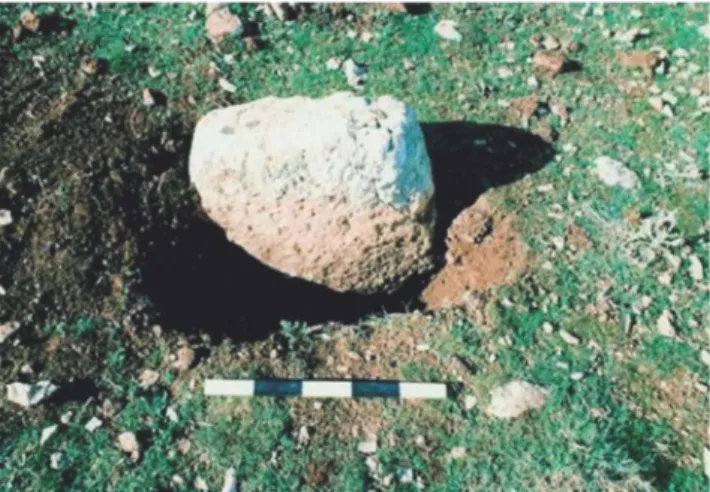
the Çoban Creek Pass, which serves as a passageway be tween Harran Plain and Viranşehir region (Fig. 2). It is a small mound established on a ridge formed by high cal¬ careous plateaus, which is very poor in terms of soil. The western section of the mound that covers approximate ly 1-decare area is distorted due to illegal excavations. Moreover, a high voltage transmission line pole is locat ed at the north end of the mound. Small cavern groups and a pool carved to the bedrock are determined at the calcareous rocks surrounding the mound. Furthermore, the quarries contemplated to be the site for extracting the " T " shaped pillars are also located northeast of the hill. A site where a " T " shaped pillar excavated and removed is identiied in an illegal excavation pit at Kurt Tepesi from Pre-Pottery Neolithic period with no ceramics (Fig. 3). During the surveys conducted at the villages in the vicinity, two pillars removed from their original site were discovered in Kösecik village located circa 6 km south east of the hill (Fig. 4)1 8.
1 8 Two "T" shaped pillars were moved from Kurt Tepesi settlement
affiliated to Sumaklı Village by Hüseyin Eyyüboğlu and Sinan Eyyüboğlu who reside in Kösecik village. Private interview with Hüseyin Eyyüboğlu, 20.10.2013. The pillars are currently in Şanlıurfa Museum.
Fig. 3: Illegal Excavation Area where " T " Shaped Pillar was Exca vated from Kurt Tepesi / Kurt Tepesi'nden"T" Şeklinde
Dikmeta-şın Çıkartıldığı Kaçak Kazı Alanı (Photo by B. Çelik).
The pillars are approximately 2.5 m long, with width varying in the range of 50 cm to 10 cm and their thick ness is 25 cm. One of the " T " shaped pillars contains both a broad groove in the form of a necktie and a sin gle-strip chevron pattern on a scalped area located at the side of the pillar (Fig. 5). The single-strip at the Chev ron pattern emerges as a feature not observed at the " T " shaped pillars discovered in Nevali Çorf9 and Göbekli
Tepe20. There is no relief on the other " T " shaped pillar21.
Fig. 4: " T " Shaped Pillars from Kurt Tepesi / Kurt Tepesi'nden
"T" Şeklinde Dikmetaşlar (Photo by B. Çelik).
19 Hauptmann/Schmidt 2007: 80. 2 0 Schmidt 2007: Fig. 11.
2 1 More comprehensive study for Kurt Tepesi archaeological site is
to be published.
Fig. 5: Necktie and Chevron Patterned Pillar from Kurt Tepesi Settlement / Kurt Tepesi Yerleşiminden Kravatlı ve Chevron Motif
li Dikmetaş (Photo by B. Çelik).
Studies conducted on Kurt Tepe revealed that the flint¬ stone is used intensively as a raw material and that the obsidian is present at very scarce quantities. The findings excavated from this site include Byblos type arrowheads made of flintstone, scrapers, drills, sickle blades and ob sidian blades. Moreover, stone beads and pestle parts made from basalt stone are also discovered.
Kurt Tepesi is considered to be a settlement of approxi¬
mately identical scale to the Sefer Tepe and Harbetsuvan
Tepesi settlements due to the similarity of the discovered
finds and its size. Dimensions of the pillars unearthed here is similar with the cult building in Nevali Çori and Layer II of Göbekli Tepe. Based on such similarity and the small finds unearthed, Kurt Tepesi settlement should be dated as late Pre-Pottery Neolithic period A (PPNA) and early Pre-Pottery Neolithic period B (PPNB).
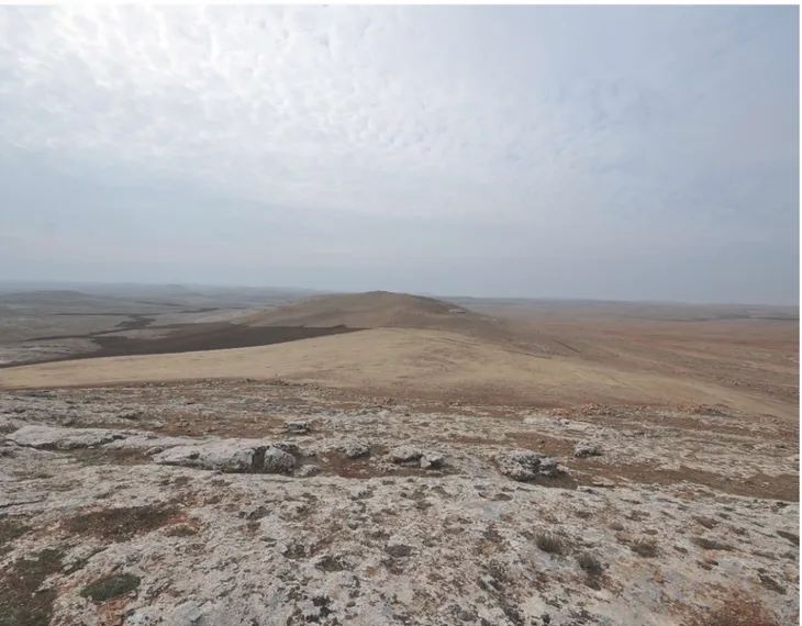
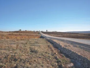
Harbetsuvan Tepesi
Discovered for the first time in 2014, Harbetsuvan Tepesi (Fig. 1) is located 45 km east of Şanlıurfa, between cal careous plateaus known as Tektek Mountains (Fig. 6). Its altitude from sea level is 114 m. The settlement covers an area of circa 6 decares. No ceramics were discovered in the settlement. Therefore, the settlement is contemplated to be inhabited only during the Pre-Pottery Neolithic pe¬ riod. The most significant characteristic of the settlement is the presence of in situ " T " shaped pillars. Several " T " shaped pillars unearthed as a result of illegal excavations are destroyed deliberatively. One of the broken pillars with no decoration is re-assembled and the pillar is iden¬ tified to be 160 cm long, 10 cm to 50 cm wide with a thickness of 22 cm (Fig. 1). Another " T " shaped pillar unearthed in the settlement contains necktie and inger reliefs (Fig. 8).
ŞANLIURFA BÖLGESİNDE " T " ŞEKLİNDE DİKMETAŞ B U L U N A N YERLEŞİMLERİN F A R K L I L I K V E BENZERLİKLERİ
Fig. 6: Southern View of Harbetsuvan Tepesi / Harbetsuvan Tepesi'nin Güneyden Görünümü (Photo by B. Çelik).
Fig.7: Pillar with no Relief at Harbetsuvan/Harbetsu- Fig. 8: Necktie and Finger Shaped Relief Pillar from Harbetsuvan Tepesi Settlement/
van 'dan Kabartmasız Dikmetaş (Photo by B. Çelik). Harbetsuvan Tepesi'nden Kravatlı ve Parmak Kabartmalı Dikmetaş (Photo by B. Çelik).
Harbetsuvan settlement is located approximately 7 km
southwest of Karahan Tepe settlement. Traces of a circu lar foundation with circa 15 m diameter are present at the site where the pillars were discovered. As it stands, the
building resembles circular "FEnclosure" discovered at Layer II/III of Göbekli Tepe22.
The studies conducted in the settlement revealed that the raw material intensively used is flintstone, and a small amount of obsidian finds are also present: bipolar cores, made of flintstone, shoulder and sickle blades, Byblos type arrowheads, and obsidian blade pieces, which are unique to Pre-Pottery Neolithic period, were discov ered23.
The pillars that resemble the pillars with no relief un¬ earthed at Harbetsuvan settlement the most were dis covered in Karahan Tepe24. The settlement seems like a satellite settlement due to its proximity to Karahan Tepe.
Harbetsuvan Tepesi is considered to be a settlement of
approximately identical scale to the Sefer Tepe and Kurt
Tepesi settlements due to the similarity of the discovered
findings.
Dimensions of the pillars unearthed here are similar with the cult building in Nevali Çori and Layer II of Göbekli
Tepe. Based on such similarity and the small inds un¬
earthed, Harbetsuvan Tepesi settlement should be dated as late PPNA and early PPNB.
Hamzan Tepe
Discovered during the provincial cultural inventory stud ies conducted in 2004, Hamzan Tepe settlement (Fig. 1) is located 2 km north of İkizce village, which is located 12 km south of Şanlıurfa province (Fig. 9). Covering an area of circa 11 decares, Hamzan Tepe is at 600 m above sea level. It is a settlement founded within the plateaus in West Harran Plain. The settlement was first used as a Paleolithic outdoor station and
then as a small sized settlement during the Neolithic period25.
One in situ " T " shaped pillar was discovered at Hamzan Tepe set tlement (Fig. 10). Moreover, re¬ mains of two circular buildings excavated as a result of illegal excavations were discovered at the eastern section of the settle¬ ment. The inner section of one of such circular buildings was excavated down to the bedrock and, fortunately, the curb stones were preserved in situ (Fig. 11). The remains of the circu lar building, in its current form, rather appear to be the remains of a domestic building.
Fig. 9: View of Hamzan Tepe Settlement from West / Hamzan Tepe
Yerleşiminin Batıdan Görünümü (Photo by B. Çelik).
Fig. 10: "T" Shaped insitu Pillar Example from Hamzan Tepe /
Hamzan Tepe'den "T" Şeklinde in-situ Dikmetaş Örneği (Photo by B. Çelik).
Fig. 11: Remains of Circular Building from Hamzan Tepe Settlement / Hamzan Tepe Yerleşimin
den Yuvarlak Planlı Yapı Kalıntıları (Photo by B. Çelik). 2 3 More comprehensive study for Harbertsuvan Tepesi archaeo
logical site is to be published.
2 4 Çelik 2011b: Figs. 8, 10.
ŞANLIURFA BÖLGESİNDE "T" ŞEKLİNDE DİKMETAŞ BULUNAN YERLEŞİMLERİN F A R K L I L I K VE BENZERLİKLERİ
Hamzan Tepe settlement resembles Çayönü26 and Neva
li Çori21 settlements as it accommodates both domestic buildings and a " T " shaped pillar. The settlement sites in Şanlıurfa region that accommodate both cult buildings and domestic buildings are Hamzan Tepe and
Şanlıur-fa-Yeni Mahalle.
Although the studies conducted revealed no ceramics presence at the settlement, indings from Lower Paleo¬ lithic period28 made of flintstone and Byblos and
Nem-rik type arrowheads unique to the Pre-Pottery Neolithic period and very scarce obsidian blades and lakes were
discovered29. One El-Khiam arrowhead was discovered
at the same site during a survey conducted in 2013. There is no relief mark of any kind on the pillars dis¬ covered in Hamzan Tepe settlement. The width of the pillars varies in the range of 10 cm to 50 cm, and its thickness is 22 cm. The length could not be measured,
as it is half-buried to the ground. However, its apparent dimensions indicate that it is approximately the same size with the pillars from Karahan Tepe, Sefer Tepe, Taşlı
Tepe, Kurt Tepesi and Harbetsuvan Tepesi. Based on the
dimensions of the pillars discovered at Hamzan Tepe, the settlement is contemplated to be contemporaneous with Layer II of Göbekli Tepe and the cult building discovered in Nevali Çori and Hamzan Tepe settlements should be dated as late PPNA and early PPNB.
Karahan Tepe
Discovered for the first time in 2000 during provincial cultural inventory studies, Karahan Tepe (Fig. 1) is lo cated circa 63 km east of Şanlıurfa, between calcareous plateaus known as Tektek Mountains (Fig. 12)30. Its al
titude from sea level is 690 m. A comprehensive study conducted in 2013 precisely revealed that Karahan Tepe settlement covers an area of 110 decares.
Fig. 12: View of Karahan Tepe Settlement from East / Karahan Tepe Yerleşiminin Doğudan Görünümü (Photo by B. Çelik).
2 6 Erim-Özdoğan 2011: Figs.19, 32, 35-37. 2 7 Hauptmann 2007: Fig. 26.
2 8 Çelik 2010: Figs. 10-14.
The most significant characteristics of the settlement are that it was inhabited only during the Pre-Pottery Neolith¬ ic period and its presence of 266 in situ " T " shaped pil lars (Fig. 13). Some of the " T " shaped pillars revealed as a result of illegal excavations bear round-headed reliefs while some others bear triangular headed snake31 reliefs
that resemble snake reliefs at Göbekli Tepe32. One pillar fragment, on the other hand, contains reliefs of some feet of an animal, depicted mutually33. Animal figures created
using scraping technique are discovered on some pillar fragments34. Moreover, fragment of a sculpture depicted
with male sexual organ, likes of which are encountered at Göbekli Tepe, was also discovered35. The quarry
identi-ied at Karahan Tepe settlement, wherein a 5 m long " T " shaped pillar36 not carved out is present, is an indication
that the settlement bears similar features with Göbekli
Tepe31.
Fig. 13: In situ " T " Shaped Pillar from Karahan Tepe Settlement /
Karahan Tepe Yerleşiminden in situ "T"Şeklinde Dikmetaş. (Pho to by B. Çelik).
31 Çelik 2011b: Figs. 8-11. 3 2 Schmidt 2007: Fig. 20. 3 3 Çelik 2011b: Figs. 14-15. 3 4 Çelik 2011b: Fig. 12a-b. 3 5 Çelik 2011c: 91-95. 3 6 Çelik 2011b: Fig. 6. 3 7 Schmidt 1998: 4.
The studies conducted in the settlement revealed bipo¬ lar cores, end scrapers, drills, chisels, sickle blades, By-blos, Nemrik and Aswad type arrowheads unique to the Pre-Pottery Neolithic period38.
The pillars from Karahan Tepe settlement are approxi¬ mately of the same size with the pillars from Sefer Tepe,
Hamzan Tepe, Taşlı Tepe, Kurt Tepesi and Harbetsuvan Tepesi. Based on the dimensions of the pillars discov¬
ered at Karahan Tepe, the settlement is contemplated to be contemporaneous with Layer II of Göbekli Tepe and the cult building discovered in Nevali Çori. The culture layer of Karahan Tepe settlement is estimated to be in the range of 1-8 m at minimum as derived from the illegal excavation pit of 10 m radius. Karahan Tepe settlement should be dated as late PPNA and early PPNB for now in the light of currently available information.
Karahan Tepe settlement, with current dimensions, is a
settlement equivalent of Göbekli Tepe. Relieved, scraped and neck-tie shaped pillars were discovered at the settle¬ ment. However, pillars with arm and finger reliefs known from Göbekli Tepe and Nevali Çori are not encountered yet.
Taşlı Tepe
Taşlı Tepe is located circa 1 km north of Basbük village
located approximately 65 km northeast of Şanlıurfa, within modern borders of Siverek district (Fig. 1). This settlement site was discovered for the irst time in 2011 during provincial cultural inventory studies39.
Altitude of Taşlı Tepe settlement above sea level is 140 m. The settlement covers an area of circa 12 decares (Fig. 14). The land on which the settlement is founded is cur¬ rently used for agricultural purposes. The settlement is surrounded with high plateaus from north and east. The southern and western parts rather demonstrate a partially smooth terrain.
When we look at the lithic tools discovered from Taşlı
Tepe as a whole, typologically toll varieties from
Pre-Pot-tery Neolithic period can be seen, which are Byblos type arrowheads made of Flintstone, lower and upper grind¬ ing stones, stone dish, hand axe made of boulder, small chisel, pestles and stone vessels40. Moreover, a bead in
the form of a bull head made of green boulder stone was also discovered41.
3 8 Çelik 2011b: Fig. 20-21.
3 9 Çelik/Güler/Güler 2011: 226, 229. 4 0 Çelik/Güler/Güler 2011: Figs. 2-5. 4 1 Çelik/Güler/Güler 2011: Fig. 6.
ŞANLIURFA BÖLGESİNDE "T" ŞEKLİNDE DİKMETAŞ B U L U N A N YERLEŞİMLERİN F A R K L I L I K V E BENZERLİKLERİ
Fig. 14: View of Taşlı Tepe Settlement from East / Taşlı Tepe Yerleşiminin Doğudan Görünümü (Photo by B. Çelik).
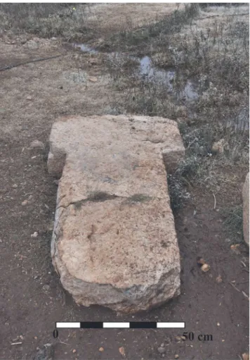
The most interesting finds excavated at Taşlı Tepe settle ment are the " T " shaped pillar fragments located in the courtyard of a house in Başbük village. 4 " T " shaped pil lar fragments were revealed at an excavation of approx imately 1 m x 8 m to 1 m depth at the southeast hillside of the settlement. All pillars are made of limestone. One of the pillars unearthed in fragmented form was reassem¬ bled and identified to be 152 cm long, 93 cm wide at the capital part with a thickness of 22 cm (Fig. 15). Based on the dimensions of the pillars discovered at Taşlı Tepe, the settlement is contemplated to be contemporaneous with Layer I I of Göbekli Tepe and the cult building discov ered in Nevali Çori42. Moreover, the pillars from Taşlı
Tepe settlement are approximately of the same size with the pillars from Karahan Tepe42, Göbekli Tepe Layer I I4 4,
Sefer Tepe, Hamzan Tepe, Kurt Tepesi and Harbetsuvan Tepesi. No relief or scraping marks of any kind were en¬
countered on the Taslı Tepe pillars. A fragment of terazzo floor specimen was also discovered at the same site45.
4 2 Hauptmann 1991/1992: 28, Abb. 21. 4 3 Çelik 2000b: 6-7, Fig. 1; 2011b: Figs. 9-10.
4 4 See Schmidt 2002:8, Fig,7. The pillars at L10-71, L9-80, L9-55
and L9-56 excavations.
4 5 Çelik/Giiler/Giiler 2011: Fig. 8.
Fig. 15: Pillar from Taşlı Tepe Settlement / Taşlı Tepe'den Dikme
Taslı Tepe settlement should be dated as late PPNA and
early PPNB due the similarities with Layer II of Göbekli
Tepe and the cult building pillars at Nevali Çori.
Sefer Tepe
Sefer Tepe settlement is located approximately 10 km
east of Şanlıurfa within borders of Viran Şehir district46.
The settlement appears as a small and shallow mound founded on a flat land (Fig.16). The settlement is found¬ ed at a spot where the plateau ends and the plain starts to extend. The settlement is 100 m above sea level. It covers an area of circa 10 decares41. The settlement site
is founded on bed rock and is approximately 1 m high. A plain known as Viran Sehir plain extends at the north and east of Sefer Tepe settlement. The south is partially lat terrain and the west contains high plateaus known as
Tek Tek Dağları.
Fig. 16: View of Sefer Tepe Settlement from East / Sefer Tepe Yer
leşiminin Doğudan Görünümü (Photo by B. Çelik).
There are 16 in-situ " T " shaped pillars present at the set¬ tlement. The pillars are positioned mutually48. With these
positions, they resemble the pillars at Göbekli Tepe Layer II architecture49, Nevali Çori pillars50 and the in-situ pil
lars at the surface of Karahan Tepe61. Moreover, they are approximately the same size with the pillars from Taşlı
Tepe, Hamzan Tepe, Karahan Tepe, Kurt Tepesi and Har-betsuvan Tepesi pillars.
An intact " T " shaped pillar of 198 cm long 15 cm to 50 cm wide and 30 cm thick unearthed as a result of illegal excavations at the settlement (Fig. 11) was discovered. Other pillars discovered are all in fragments. Another pil-4 6 Çelik 2006a: 23-25; Gûler/Çelik/Gûler 2012: 161-162,168-169. 4 7 Wrong values were published in the previous version (see Çelik
2006a: 23).
4 8 Çelik 2006a: 23.
4 9 Schmidt 2002: 8, Figs. 7. L10-71, L9-80, L9-55 and L9-56 ex
cavations.
5 0 Hauptmann 1991/1992: 28, Abb. 21. 51 Çelik 2000b: 6-7.
lar fragment 10 cm wide and 40 cm thick excavated from the settlement resembles the pillar located at the center of the cult building at Nevali Çori. This pillar fragment should, most probably, be one of the pillars at the center of the cult building contemplated to be present also at
Sefer Tepe.
Fig. 11: Pillar Example from Sefer Tepe / Sefer Tepe'den Dikmetaş
Örneği (Photo by B. Çelik).
Byblos type arrowheads made of lintstone, sickle blades, cores, stone vessel fragments and, although in scarce quantities, blade fragments made of obsidian were dis¬ covered at the settlement52.
Sefer Tepe settlement should be dated as late PPNA and
early PPNB due the similarities with Layer II of Göbekli
Tepe and the cult building pillars at Nevali Çori.
ŞANLIURFA BÖLGESİNDE "T" ŞEKLİNDE DİKMETAŞ B U L U N A N YERLEŞİMLERİN F A R K L I L I K V E BENZERLİKLERİ
Ayanlar Höyük
Discovered in 2013 for the first time, Ayanlar Höyük is located underneath and north of Ayanlar village53 located
circa 30 km west of Şanlıurfa (Fig. 1). The settlement covers an area of circa 140 decares. The height of the mound is approximately 10 m. Its altitude from sea lev el is 133 m. The village settlement covers the southern and eastern section (Fig.18). There are 5 small hills on the mound. The surface of the mound is completely de¬ stroyed due to agricultural activities. Today, the land is covered with pistachio groves. The studies conducted, revealed ceramics from early and middle Byzantium pe riods as well as finds from Pre-Pottery Neolithic period. Moreover, blade, flake fragments, arrowhead and scraper fragments all made of flintstone, bipolar and mono-po lar cores and core renewal pieces, shoulder blades, ham mers, and very scarce obsidian flakes and blades were encountered. Stone jars made of limestone, basalt lower and upper grinding stones and pestles, chlorite stone ves sel fragments, and stone dish fragments are amongst the finds discovered from the site54.
Fig. 18: Ayanlar Höyük, View from North / Ayanlar Höyüğü, Ku
zeyden Görünüm (Photo by B. Çelik).
A pedestal piece with hollow center that we know made for " T " shaped pillars55 was discovered at the village
cemetery located on one of the hills at the mound (Fig. 19). Although no " T " shaped pillar was discovered at
Ayanlar Höyüğü, several finds unearthed here give im
portant hints that this settlement might be a cult center just like Göbekli Tepe and Karahan Tepe. In particular, a
statue fragment considered to be a lion's head unearthed here points out to the fact that Ayanlar Höyüğü accom¬ modated cult buildings56.
53 Former name of Ayanlar village is Hut village. Ayanlar Mound
is also called as "Gre Hut" by the local community.
5 4 More comprehensive study for Ayanlar Höyük archaeological
site is to be published.
55 Schmidt 2010: Fig. 21.
56 Ercan/Çelik 2013: Figs. 1a-d, 2a-d, 3a-d.
Fig. 19: Ayanlar Höyük, Pedestal Fragment with Hollow Center/'Ayan
lar Höyüğü'nden Ortası Oyuk Kaide Parçası (Photo by B. Çelik).
Ayanlar Höyük settlement should be dated as late PPNA
and early PPNB due the similarities with Layer I I of
Göbekli Tepe and the cult building pillars at Nevali Çori.
Şanlıurfa-Yeni Mahalle
Şanlıurfa-Yeni Mahalle is a settlement located at Şanlıur
fa downtown area within the ancient ramparts of Şanlıur fa. The settlement is underneath Yeni Mahalle district, which accommodates Balıklıgöl sacred area. In 1991 an excavation was carried out at the ground section of 15 m on Yeniyol Avenue in Yeni Mahalle district51.
The excavation carried out revealed two terrazzo loors of circular buildings. The circular wall of one of the loors were unearthed and revealed as intact, although partial¬ ly. The small indings discovered from the section are Byblos and Aswad type arrowheads made of flintstone, sickle blades, shoulder blades, cores and very scarce ob sidian flakes, and arrowhead fragments. The C14 analy¬ ses performed on the carbonated plant remains revealed that the settlement is dated back to cal. 8600 BC5 8.
5 7 Çelik 2000a: 4-6; 2007: Metin.165-178, Levha.134-146; Çelik
2011a: 139-164.
A statue with exact human size standing 1.93 m tall was discovered in 1993 during an excavation work carried out for landscaping works at the same area (Fig. 20). More over, fragment of the body of a " T " shaped pillar was discovered within wall texture at the entrance section of a cave during the ground survey conducted in Yeni Mahal¬ le district (Fig. 21). A necktie shaped broad groove is lo¬ cated at the lateral surface of this body fragment. Necktie shaped broad groove is a feature typically encountered at the pillars discovered in Göbekli Tepe, Nevali Çori, Kurt
Tepesi, Karahan Tepe and Harbetsuvan Tepesi.
Fig. 20: Şanlıurfa-Yeni Mahalle, Urfa Statue / Şanlıurfa-Yeni Ma
halleden Urfa Heykeli (Photo by G. Tan).
Fig. 21: A Necktie Shape Patterned Pillar Fragment from Yeni Mahal le District / Yeni Mahalle Semtinden Kravatlı Bir Dikmetaş Parçası
(Photo by B. Çelik).
A pillar fragment containing necktie shaped groove dis covered during the studies conducted in Yeni Mahalle district resembles Layer II of Göbekli Tepe and the cult building pillars at Nevali Çori due to its dimensions. Şan
lıurfa-Yeni Mahalle settlement should be dated as late
PPNA and early PPNB in the light of currently available information.
ASSESSMENT AND CONCLUSION
The cult buildings we know from Göbekli Tepe and Ne
vali Çori are structures that accommodate " T " shaped
relieved or non-relieved pillars and statues. We hold sig nificant amount of information on such type of cult build ings by virtue of the excavations carried out in Göbekli
Tepe. In particular, Layer II of Göbekli Tepe dated to ear¬
ly PPNB and Layer III dated to PPNA offered us new information on cult buildings59.
No center from PPNA period, in particular, contempo¬ raneous with Layer III of Göbekli Tepe was encountered in Şanlıurfa region during the studies conducted so far.
Karahan Tepe and Ayanlar Höyük are settlements that
cover more than 100 decares. With the surface area of 100 decares, Göbekli Tepe is approximately of the same size with both settlements. Such settlements are not ex cavated yet; thus it is very difficult to mention anything definite. However, the lower layers of Karahan Tepe and
Ayanlar Höyük might contain circular buildings that ac¬
commodate pillars, which we know from Layer III of
Göbekli Tepe, because both her settlements contain a cul
tural layer of approximately 7-8 meters, just like the case in Göbekli Tepe.
The centers in Şanlıurfa region that accommodate both " T " shaped pillars and circular domestic buildings are only Hamzan Tepe and Yeni Mahalle settlements. Such circular domestic building varieties are rather encoun¬ tered at the Neolithic settlements in Tigris region. The circular buildings in Tigris region are usually from PPNA phase of Neolithic period and are structures that vary also in terms of material used. The circular buildings discov¬ ered in Şanlıurfa region, on the other hand, rather rep¬ resent late PPNA and early PPNB when considered in terms of small finds. C14 analysis made at Yeni Mahalle further supports this fact60.
As a result of the excavations carried out in Nevali Çori and Çayönü, it is understood that the cult buildings dated particularly to early and middle periods of PPNB in both settlements are located at one corner of the settlement. A similar case might be valid also for Yeni Mahalle and
Hamzan Tepe cases. However, we currently lack any data
5 9 Schmidt 2010: 239-256.
ŞANLIURFA BÖLGESİNDE "T" ŞEKLİNDE DİKMETAŞ BULUNAN YERLEŞİMLERİN F A R K L I L I K V E BENZERLİKLERİ
that might support our notion as no comprehensive exca¬ vation is made either at Hamzan Tepe or at Yeni Mahalle for now.
Until this day, no findings similar to large buildings with " T " shaped pillars located at Layer I I I of Göbekli Tepe was discovered at the recently discovered Neolithic set¬ tlements in in Şanlıurfa region. The traces of the wall that we contemplate to be from a circular structure of approximately 15 m radius unearthed in Harbetsuvan
Tepesi and the pillars located within such walls should
probably be contemporaneous with "F Enclosure" re vealed at Göbekli Tepe64. "F Enclosure" is a building dated between Layers I I and I I I of Göbekli Tepe and the size of the pillars it contains is rather similar to the Layer II pillars.
Sefer Tepe, Hamzan Tepe, Taşlı Tepe, Kurt Tepesi, and Harbetsuvan Tepesi resemble each other in terms of
surface area. These settlements are not large scale set¬ tlements like Göbekli Tepe, Karahan Tepe, and Ayanlar
Höyük settlements. However, all cover an area that varies
in the range of 6 to 20 decares. At the same time, the " T " shaped pillars discovered at these settlements have same dimensions. In particular, the pillars at these settlements are approximately of the same size with the pillars from
Göbekli Tepe "FEnclosure" and Layer I I pillars and Ne-vali Çori cult building pillars.
When we consider the settlements in terms of distance between them and their locations; the fact that there are settlements located around Sefer Tepe settlement at dis¬ tances in the range of 3 to 5 km, some of which contain¬ ing circular domestics buildings, suggests that Sefer Tepe is a locality that acts somehow as a small sized cult cen-ter62. Likewise, three Neolithic settlements were discov¬
ered at the southern section of Harbetsuvan Tepesi during the studies conducted in 2014. Such settlements are also Neolithic settlements with fully domestic features. A similar case is also valid around Ayanlar Höyük, which covers an area of approximately 140 decares. Discovery of six Neolithic settlements during the studies conducted only at the southern part of Ayanlar Höyük further sup¬ ports this fact. Therefore, it would not be wrong to recite already that domestic settlements are scattered around each center that act like either large or small scale cult center during the Neolithic period at Şanlıurfa region. This feature points out to a settlement scheme that we never encountered before at the Neolithic settlements in the region.
When we look at the distances between the Neolithic settlements that accommodate pillars in Şanlıurfa region, 61 Schmidt 2010: Fig. 2.
6 2 Güler/Çelik/Güler 2013: Map 1.
we can easily mention that these settlements are found¬ ed at distances in the range of 1 to 31 km. The air dis¬ tance between Ayanlar Höyük settlement located west of Harran Plain and Karahan Tepe settlement located east of Harran Plain is approximately 66 km. The distance between Göbekli Tepe and Karahan Tepe and Ayanlar
Höyük settlements, however, varies in the range of 32 to
31 km. That is to say, the distances between Göbekli Tepe located north of Harran Plain and Ayanlar Höyük located west of Harran Plain and Karahan Tepe located east of Harran Plain, all three of which presenting similar sizes, are almost identical (Fig. 22).
N.Ç. N J(S.T. A. H i t V k r U ^ K T J(S.T. 0 _ _ 2 0 km 1 u / Hs.T. H.T.I Harran \ Ovası )
Fig. 22: Probable Routes between Settlements with Pillars at Urfa Region / Urfa Bölgesinde Dikmetaşlı Yerleşimlerin Arasındaki
Olası Rotalar (Drawing by B. Çelik).
Kurt Tepesi settlement is a site that accommodates " T "
shaped pillars. What is interesting here is that this set¬ tlement is at almost same distance to Karahan Tepe and
Taşlı Tepe. Karahan Tepe, Taşlı Tepe, and Kurt Tepesi
settlements are positioned in north-south alignment with approximately 15 km distances in-between. The common trait of these settlements not yet excavated is that all three settlements contain sites that served for cult purposes. The distance between Karahan Tepe and Harbetsuvan
Tepesi is 7 km, which is the shortest distance between
discovered settlements that contain pillars. Both settle¬ ments present the features of a cult center. Harbetsuvan
Tepesi covers an area of 6 decares while Karahan Tepe
covers an area of 110 decares. The surface of both set tlements contains " T " shaped pillars with identical size. This fact clearly indicates that both settlements existed at the same periods and were in relation with each other.
Taşlı Tepe settlement is also characterized as a center
that accommodates " T " shaped pillars. The settlements most contemporaneous to this settlement are Sefer Tepe settlement located 28 km southeast air distance, Karah
an Tepe settlement located l0 km southeast, and Göbekli Tepe settlement located 35 km west, all from Pre-Pot
tery Neolithic period. The fact that Taşlı Tepe is at almost same distance to Sefer Tepe, Karahan Tepe and Göbekli
Tepe indicates that the distance between the settlements
that contain " T " shaped pillars follows certain logic. Kurt
Tepesi settlement located 15 km southwest of Taşlı Tepe
however, violates such generalization. Nevertheless, the fact that Kurt Tepesi is founded on a hill that dominates a pass suggests that it might be a settlement founded for another reason. Such settlements contemplated to be founded in terms of hunting strategies are generally lo¬ cated on high plateaus63.
Settlements from Pre-Pottery Neolithic period are gen¬ erally founded on or in the vicinity of high plateaus in the region. Likewise, Başaran Höyük, Herzo Tepesi and Kocanizam Tepesi settlements are settlements founded on high plateaus and on the bedrock. Such settlement tradition is also known from Sefer Tepe, Taşlı Tepe, Kar ahan Tepe, Göbekli Tepe, Şanlıurfa-Yeni Mahalle and Hamzan Tepe Pre-Pottery Neolithic settlements.
Presence of circular buildings constructed for domestic purposes that we encounter at Herzo Tepesi and Hamzan
Tepe is an important fact as it demonstrates use of two
distinct architectural traditions in the region during Pre-Pottery Neolithic period64. Presence of settlements
such as Göbekli Tepe, Karahan Tepe, Taşlı Tepe and
Sefer Tepe that present cult center features as revealed
during the studies conducted so far suggests that domes¬ tic settlements should also be present at the region. Amongst the settlements under study in the region, both " T " shaped pillar and remains of circular building are encountered only at Hamzan Tepe settlement65. A sim¬
ilar case is also known from Şanlıurfa-Yeni Mahalle settlement66. Buildings constructed to an architectural
tradition similar to the remains of circular buildings are encountered at Herzo Tepe61, İnanlı Tepe68 and Hamzan
Tepe'de69 during the recent surveys conducted at Şanlıur¬ fa region in the last years.
Such buildings are probably examples of domestic archi¬ tecture and should be structures from early Pre-Pottery Neolithic period. Similar buildings are also encountered at several other settlements such as Çayönü10, Hallan
Çemi11, Gusir Höyük11, Hasankeyf Höyük12 and Körtik
Tepe14 in the region. 6 3 Özdoğan 2011:229.
6 4 Güler/Çelik/Güler 2013: Figs. 8, 14.
6 5 Çelik 2004: Fig. 4; 2006: Fig. 5; 2010: Figs. 2, 4.
6 6 Çelik 2000a: Fig. 3; Çelik 2001: 162, Fig.16; Çelik 2011a: 142,
Figs. 14-16. 6 1 Güler/Çelik/Güler 2012:Fig. 4. 6 8 Güler/Çelik/Güler 2013: Fig. 8. 6 9 Çelik 2010: Fig. 4. 1 0 Erim-Özdoğan 2011: 191-193, Figs. 6, 9. 11 Rosenberg 2011: 61-63, Figs. 2-6. 1 2 Karul 2011: 2-4, Fig. 4-5, 11. 1 3 Miyake/Maeda/Tanno/Hongo/Gündem 2012: Fig. 3. 1 4 Özkaya/Coşkun 2011: 90-93, Figs. 2-5.
During the studies conducted in 2013, pillars similar to "T" shaped pillars were discovered at Kurt Tepesi. One of the pillars unearthed from Kurt Tepesi contain a groove in the form of neck-tie, which we recognize from
Göbekli Tepe16 and Nevali Çori16 and chevron pattern re lief. The chevron pattern on the " T " shaped at Kurt Te
pesi was made to as single rather than dual just like the
patterns at Nevali Çori and Göbekli Tepe.
Harbetsuvan Tepesi settlement, which accommodates
" T " shaped pillars, is a settlement discovered for the first time during the studies conducted in 2014. No re¬ liefs were encountered on numerous fragmented pillars discovered at this settlement. However, the body of one pillar bears necktie and inger reliefs.
Studies were conducted at a zone located circa 25 km west of Şanlıurfa downtown area in order to identify where the two artifacts from Neolithic period brought to
Şanlıurfa Museum77 in 2013. During such studies, Ayan
lar Höyüğü that covers an area of approximately 140 de¬
cares was discovered. The fact that stone vessels are dis¬ covered during the studies conducted here and that this settlement was inhabited during Pre-Pottery Neolithic period consolidated our opinion.
The era of the " T " shaped pillars unearthed from
Kar-ahan Tepe, Hamzan Tepe, Sefer Tepe, Taşlı Tepe, Kurt Tepesi and Harbetsuvan Tepesi settlements present fea¬
tures similar especially to "FEnclosure" and Layer II of
Göbekli Tepe and the cult building at Nevali Çori'. It is
possible for us to say that there was a breakdown period experienced after Layer III of Göbekli Tepe, and there¬ after the number of settlements contemporaneous with
Göbekli Tepe Layer II increased amongst the Neolithic
settlements in Urfa region and become widespread all around the region78.
In conclusion, Şanlıurfa-Yeni Mahalle, Karahan Tepe,
Hamzan Tepe, Sefer Tepe and Taşlı Tepe settlements dis¬
covered in the last years and recently discovered Ayanlar
Höyük, Kurt Tepesi and Harbetsuvan Tepesi settlements
should be dated as late PPNA (9100-8800 BC) and early PPNB (8800-8400 BC) in the light of recent discover ies79. 7 5 Schmidt 2007: 118, Fig.11. 7 6 Hauptmann 1993: 51-53, Abb.16. 7 7 Ercan/Çelik 2013: 25-27. 7 8 Schmidt 2005: 13-19, Fig. 1. 7 9 Çelik 2014: Tab 1.
ŞANLIURFA BÖLGESİNDE "T" ŞEKLİNDE DİKMETAŞ BULUNAN YERLEŞİMLERİN F A R K L I L I K V E BENZERLİKLERİ BIBLIOGRAPHY
BEILE-BOHN, M/GERBER, C.H/MORSCH M/ SCHMIDT, K. 1998.
"Frühneolithische Forschungen in Obermesopotamien. Göbekli Tepe und Gürcütepe", Istanbuler Mitteilungen 48: 1998 5-18.
BULGAN, F/ÇELİK, B. 2011.
"A New Statue From Gaziantep in Southeast Turkey / Türkiye'nin Güneydoğusundaki Gaziantep'ten Yeni Bir Heykel", Işın Yalçınkaya'ya Armağan Kitabı/Studies in Honor of Işın Yalçınkaya (Eds. H. Taşkıran/M. Kartal/K. Özçelik/G. Kartal). Ankara: 85-90.
ÇELİK B. 2000a
"A New Early Neolithic Settlement in the Center of Şan¬ lıurfa, Turkey", Neo-Lithics 2/3: 4-6.
ÇELİK, B. 2000b.
"A New Early-Neolithic Settlement: Karahan Tepe", Neo-Lithics 2/3: 6-8.
ÇELİK, B. 2004.
"A New Early-Neolithic Settlement: Hamzan Tepe", Neo-Lithics 2/4: 3-5.
ÇELİK, B. 2005.
"A New Statue of the Early Pre-Pottery Neolithic Period from Gaziantep, Southeastern Turkey", Neo-Lithics 1/5: 28-29.
ÇELİK, B. 2006a.
"A New Pre-Pottery Neolithic Site in Southeastern Tur¬ key: Sefer Tepe", Neo-Lithics 1/6: 23-25.
ÇELİK, B. 2006b.
"A New Lower Paleolithic Open Air Station and Ear¬ ly Neolithic Settlement", Hayat Erkanal'a Armağan. Kültürlerin Yansıması/Studies in Honor of Hayat Er¬ kanal. Cultural Relections (Eds. A. Erkanal-Öktü/E. Özgen/S. Günel/A. T. Ökse/H. Hüryılmaz/H. Tekin/N. Çınardalı-Karaaslan/B. Uysal/F. A. Karaduman/A. En¬ gin/R. Spiess/A. Aykurt/R. Tuncel/U. Deniz/A. Rennie). İstanbul: 222-224.
ÇELİK, B. 2001.
"Şanlıurfa-Yeni Mahalle, Balıklıgöl Höyüğü", Anado¬ lu'da Uygarlığın Doğuşu ve Avrupa'ya Yayılımı Türki¬ ye'de Neolitik Dönem. Yeni Kazılar. Yeni Bulgular. (Eds. M. Özdoğan / N. Başgelen). İstanbul: 165-118.
ÇELİK, B. 2010.
"Hamzan Tepe in the Light of New Finds", Documenta Praehistorica X X X V I I : 251-268.
ÇELİK, B. 2011a.
"Şanlıurfa-Yeni Mahalle", The Neolithic in Turkey. New Excavation and New Research/The Euphrates Basin (Eds. M. Özdoğan/N. Başgelen/P. Kuniholm). İstanbul:
139-164.
ÇELİK, B. 2011b.
"Karahan Tepe: A New Cultural Centre in Urfa Area in Turkey", Documenta Praehistorica X X X V I I I : 241-253. ÇELİK, B. 2011c.
"A New Statue from Karahan Tepe", Işın Yalçınkaya'ya Armağan Kitabı. Studies in Honor of Işın Yalçınkaya (Eds. H. Taşkıran/M. Kartal/K. Özçelik/G. Kartal). An¬ kara: 91-95.
ÇELİK, B. 2014.
"Şanlıurfa-Yeni Mahalle Höyüğü in the Light of Novel C14 Analysis /Yeni Karbon 14 Analizleri Işığında Şan-lıurfa-Yeni Mahalle Höyüğü", Armizzi Engin Özgen'e Armağan / Studies in Honor of Engin Özgen (Eds. A. Engin/B. Helwing/B. Uysal). Ankara: 101-106.
ÇELİK, B/GÜLER, M./GÜLER, G. 2011.
"Türkiye'nin Güneydoğusunda Yeni Bir Çanak Çöm-leksiz Neolitik Yerleşim: Taşlı Tepe / A New Pre-Pot-tery Neolithic Settlement in Southeastern Turkey: Taşlı Tepe", Anadolu/Anatolia 37: 225-236.
ERCAN, M/ÇELİK, B. 2013.
"Şanlıurfa Müzesi'nden Neolitik Döneme Ait Bir Grup Eser / A Group of Artifacts From Neolithic Period in Şan¬ liurfa Museum", Anadolu/Anatolia 39: 13-54.
ERİM-ÖZDOĞAN, A. 2011.
"Çayönü", The Neolithic in Turkey, New Excavation and New Research. The Tigris Basin (Eds. M. Özdoğan/N. Başgelen/P. Kuniholm). İstanbul: 185-269.
GÜLER, M/ÇELİK, B/GÜLER, G. 2012.
"Viranşehir İlçesinden Yeni Çanak Çömleksiz Neolitik Dönem Yerleşimleri / New Pre-Pottery Neolithic Settle¬ ments from Viranşehir District", Anadolu/Anatolia 38:
157-191.
GÜLER, G/ÇELİK, B/GÜLER, M. 2013.
"New Pre-Pottery Neolithic Sites and Cult Centres in the Urfa Region", Documeta Praehistorica X L : 291-304. HAUPTMANN, H. 1991/92.
"Eine Siedlung des akeramischen Neolithikums am mit¬ tleren Euphrat", NüBlA 8/9: 15-33.
HAUPTMANN, H. 1993.
"Ein Kultgebäude in Nevali Çori", Between the Rivers and the Mountains. Archaeologica Anatolica et Mesopo tamia Alba Palmieri Dedicata (Eds. M. Frangipane/H. Hauptmann/M. Liverani/P. Matthiae/M. Mellink). Roma: 37-69.
HAUPTMANN, H. 1999.
"The Urfa Region", Neolithic in Turkey. The Cradle of Civilization. New Discoveries (Eds. M. Özdoğan/N. Başgelen). İstanbul: Text 66-86, Plates, 37-56, Pl. 1-35. HAUPTMANN, H. 2000.
"Ein fruhneolithisches Kultbild aus Kommagene", Gottkönige am Euphrat: Neue Ausgrabungen und For schungen in Kommagene (Eds. J. Wagner). Mainz: 5-9. HAUPTMANN, H. 2007.
"Nevali Çori ve Urfa Bölgesinde Neolitik Dönem", Anadolu'da Uygarlığın Doğuşu ve Avrupa'ya Yayılımı. Türkiye'de Neolitik Dönem. Yeni Kazılar Yeni Bulgular (Eds. M. Özdoğan/N. Başgelen). İstanbul: 131-164. HAUPTMANN, H. 2012.
"Ein fruhneolithisches Kultbild aus Kommagene", Gottkönige am Euphrat: Neue Ausgrabungen und For¬ schungen in Kommagene (Eds. J. Wagner). Darmstadt/ Mainz: 13-22.
HAUPTMANN, H/SCHMIDT, K. 2007.
Die Skulpturen des Frühneolithikums. In Badisches Landesmuseum Karlsruhe, Vor 12 000 Jahren in Anato-lien. Die ältesten Monumente der Menschheit. Begleit¬ band zur großen Landesausstellung Baden-Württemberg im Badischen Landesmuseum 2007. Theiss. Stuttgart: 67-82.
K A R U L , N. 2011.
"Gusir Höyük", The Neolithic in Turkey, New Exca¬ vation and New Research. The Tigris Basin (Eds. M. Özdoğan/N. Başgelen/P. Kuniholm). İstanbul: 1-17. MIYAKE, Y/MAEDA, O/TANNO, K/HONGO, H/ GÜNDEM, C.Y. 2012.
"New Excavations at Hasankeyf Höyük: A 10th Millenni
um cal. B C site on the Upper Tigris, Southeast Anatolia", Neo-Lithics 1/12: 3-7.
ÖZDOGAN, M. 2011.
"Anadolu İlk Neolitik Kültürlerinin Kökeni Sorunu", Işın Yalçınkaya'ya Armağan Kitabı/Studies in Honor of Işın Yalçınkaya (Eds. H. Taşkıran/M. Kartal/K. Özçe-lik/M. B. Kösem/G. Kartal). Ankara: 227-233.
ÖZKAYA, V/COŞKUN A. 2011.
"Körtik Tepe", The Neolithic in Turkey. New Exca¬ vation and New Research. The Tigris Basin (Eds. M. Özdoğan/N. Başgelen/P. Kuniholm). İstanbul: 89-121. ROSENBERG, M. 2011.
"Hallan Çemi", The Neolithic in Turkey. New Exca¬ vation and New Research. The Tigris Basin (Eds. M. Özdoğan/N. Başgelen/P. Kuniholm). İstanbul: 1-18. SCHMIDT, K. 1998.
"Beyond Daily Bread: Evidence of Early Neolithic Ritu¬ al from Gobekli Tepe", Neo-Lithics 2/98: 1-5.
SCHMIDT, K. 2001.
"Göbekli Tepe, Southeastern Turkey. A Preliminary Re¬ port on the 1995 1999 Excavations", Paleorient 26/1: 45¬ 54.
SCHMIDT, K. 2002.
"The 2002 Excavations at Göbekli Tepe (Southeast¬ ern Turkey) - Imressions from an Enigmatic Site", Neo-Lithics 2/2: 8-13.
SCHMIDT, K. 2005.
"Ritual Centers" and the Neolithisation of Upper Meso¬ potamia", Neo-Lithics 2/5: 13-21.
SCHMIDT, K. 2001.
"Göbekli Tepe", Anadolu'da Uygarlığın Doğuşu ve Avrupa'ya Yayılımı. Türkiye'de Neolitik Dönem. Yeni Kazılar, Yeni Bulgular. (Eds. M. Özdoğan/N. Başgelen). İstanbul: Metin 115-129, Levha 105-116.
SCHMIDT, K. 2010.
"Göbekli Tepe - the Stone Age Sanctuaries. New Results of Ongoing Excavations with a Special Focus on Sculp¬ tures and High Reliefs", Documenta Praehistorica XXX¬ V I I : 239-256.
WATKINS, T. 1990.
"The Origins of the House and Home", World Archaeol¬ ogy 21/3: 336-341.