THE INFLUENCE OF FAMILIARITY AND SIGNAGE ON
WAYFINDING IN ACADEMIC LIBRARIES: THE CASE OF
BILKENT UNIVERSITY LIBRARY
A Master’s Thesis
by
İDİL ESEN DURAN
Department of
Interior Architecture and Environmental Design
İhsan Doğramacı Bilkent University
Ankara
September 2016
To my wonderful parents; Esma Birer, Seyit Esen &
THE INFLUENCE OF FAMILIARITY AND SIGNAGE ON
WAYFINDING IN ACADEMIC LIBRARIES: THE CASE OF
BILKENT UNIVERSITY LIBRARY
The Graduate School of Economics and Social Sciences
of
İhsan Doğramacı Bilkent University
by
İDİL ESEN DURAN
In Partial Fulfillment of the Requirements for the Degree of
MASTER OF FINE ARTS
in
THE DEPARTMENT OF
INTERIOR ARCHITECTURE AND ENVIRONMENTAL DESGIN
İHSAN DOĞRAMACI BİLKENT UNIVERSITY
ANKARA
September, 2016
ii
ABSTRACT
THE INFLUENCE OF FAMILIARITY AND SIGNAGE ON
WAYFINDING IN ACADEMIC LIBRARIES: THE CASE OF
BILKENT UNIVERSITY LIBRARY
Duran Esen, İdil
MFA, Department of Interior Architecture and Environmental Design Supervisor: Assist. Prof. Dr. Çağrı İmamoğlu
September 2016
The purpose of the study is to investigate the relationship between utilized signage types, familiarity and confidence in respondents’ cognitive maps in academic libraries. Besides, it is to understand the influence of utilized signs on wayfinding performance. The experiment was administered in Bilkent University Library. Seventy one non-architecture university students from Bilkent University participated in the study, which was conducted in two parts. The first part was a library tour which involved reaching two target rooms. The second part utilized a questionnaire which inquired about respondents’ familiarity, confidence in their cognitive maps and signage. The study found that although newcomers had higher number of wrong turns and time spent to reach destination points, there was no difference in hesitation. As in other types of spaces, wrong turns and time spent decreased with increasing familiarity.
iii
Keywords: Academic Library, Confidence, Familiarity, Signage, Wayfinding Performance
iv
ÖZET
AKADEMİK KÜTÜPHANELERDE AŞİNALIK DURUMUNUN VE
İŞARET TÜRLERİNİN YÖN BULMAYA ETKİSİ: BİLKENT
ÜNİVERSİTESİ KÜTÜPHANESİNDE BİR ÇALIŞMA
Duran Esen, İdil
İç Mimarlık ve Çevre Tasarımı Yüksek Lisans Programı Tez Yöneticisi: Y. Doç. Dr. Çağrı İmamoğlu
Eylül 2016
Bu çalışmanın amacı akademik kütüphanelerde yararlanılan işaret türleri ile aşinalık durumu ve bilişsel haritanın güvenilirliği arasındaki ilişki durumunu araştırmaktır. Ayrıca yararlanılan işaretlerin aşinalık ve güvenilirlik açısından yön bulma yetisi üzerindeki etkilerini anlamaktır. Deney, Bilkent Üniversitesi Kütüphanesinde gerçekleşmiştir. Çalışmaya mimarlık öğrencileri haricindeki yetmiş bir öğrenci katılmıştır. Çalışma iki bölümden oluşmaktadır. İlk bölüm kütüphane içerisinde belirlenen iki odaya ulaşılan turdur. İkinci bölüm ise tur sonrasında katılımcıların aşinalık ve bilişsel haritalarının güven durumu ve işaretlerin değerlendirildiği ankettir. Çalışmanın sonucuna göre kütüphaneye ilk defa gelenlerin kütüphaneye aşina olanlara göre hatalı dönüş sayısı ve turu tamamlama süresinde artış görülürken, duraksama sayısında bir farklılık olmadığı görülmüştür. Akademik kütüphanede de önceki yapılan
araştırmalarda bahsedilen diğer mekânlar gibi aşinalık durumu arttıkça hatalı dönüş sayısı ve harcanan zaman azalmaktadır.
v
Anahtar Kelimeler: Akademik Kütüphane , Aşinalık, Güven, İşaretler, Yön Bulma Performansı,
vi
ACKNOWLEDGEMENTS
I would like to express my sincere gratitude to Assist. Prof. Dr. Çağrı İmamoğlu his invaluable support, endless patience, supervision and guidance throughout my graduate education and in this study. I consider myself as privileged for being one of his students.
I would like to thank to my jury members Assist. Prof. Dr. Yasemin Afacan and Assist. Prof. Dr. Elif Güneş for their contributions and feedbacks
I am grateful to all faculty members and staff of İhsan Doğramacı Bilkent University Department of Interior Architecture and Environmental Design and Department of Architecture.
I am mostly grateful to my family. I am indebted to my father Seyit Esen, my mother Esma Birer for their endless love and trust throughout my life but especially the patience during this study. Last but not the least; I would like to thank my husband Bertan Duran for his endless support throughout my thesis.
vii
TABLE OF CONTENTS
ABSTRACT ... ii
ÖZET ... iv
ACKNOWLEDGEMENTS ... vi
TABLE OF CONTENTS ... vii
LIST OF TABLES ... x
LIST OF FIGURES ... xii
CHAPTER 1: INTRODUCTION ... 13
1.1. Aim of the Study ... 16
1.2. Structure of the Thesis ... 16
CHAPTER 2: SPATIAL COGNITION ... 19
2.1. Definition of Cognition ... 19
2.2. Types of Spatial Knowledge ... 20
CHAPTER 3: WAYFINDING ... 23
3.1. Definition of Wayfinding ... 23
3.1.1. Strategies of Wayfinding ... 25
3.2. Factors Affecting Wayfinding Behavior ... 27
3.2.1. Physical Factors ... 27
3.2.2. Psychological Factors ... 30
viii
3.4. Signage Systems ... 33
3.4.1. Signage Types and Their Functions ... 34
3.4.2. Regulations of Signs ... 37
3.4.3. The Reasons of Problems on Signs ... 41
3.5. Familiarity and Wayfinding ... 42
3.6. Wayfinding in Libraries ... 44
3.6.1. Library as a Place ... 44
3.6.1. Wayfinding in Library ... 46
CHAPTER 4: THE STUDY... 48
4.1. Aim of the Study ... 48
4.1.1. Research Questions ... 49
4.1.2. Hypothesis ... 49
4.2. Method of the Study ... 50
4.2.1. Selecting the Destination ... 50
4.2.2. Sample ... 51
4.2.3. Questionnaire ... 52
4.2.4. Procedure ... 53
CHAPTER 5: RESULTS ... 58
5.1. Descriptive Statistics ... 58
5.2. Statistics for The Relationship between Signage Types and Wayfinding Performances ... 60
5.3. Statistics for The Relationship between Signage, Familiarity and Confidence ... 63
CHAPTER 6: DISCUSSION... 70
6. 1. Analysis of Library Signage System ... 70
6.2. Evaluation of Signage Types, Familiarity and Confidence ... 72
CHAPTER 7: CONCLUSION ... 75
ix
REFERENCES ... 78
APPENDICES APPENDIX A: LIBRARY PLANS and PHOTOGRAPHS ... 87
APPENDIX A1: Library Plans ... 88
APPENDIX A2: Library Photos ... 90
APPENDIX B: QUESTIONNAIRE and RESEARCHER NOTE CARD ... 97
APPENDIX B1: Questionnaire ... 98
APPENDIX B2: Researcher Note Card ... 101
x
LIST OF TABLES
Table 1: Subjects' number according to their sex ... 52
Table 2: Frequency tables of the study ... 103
Table 3: Correlation analysis for relationship between wrong turn, hesitation and time spent in Halil İnalcık Room ... 108
Table 4: Correlation analysis for relationship between wrong turns, hesitation and time spent in Multimedia Room ... 109
Table 5: T Test for comparison between wrong turn, hesitation and time spent for direction sign ... 110
Table 6: T test for comparison between wrong turn, hesitation and time spent for identification sign ... 111
Table 7: T Test for comparison between wrong turns, hesitations and time spent for orientation sign ... 112
Table 8: T test for comparison between wrong turn, hesitation and time spent for library using time ... 113
Table 9: T test for comparison between wrong turn, hesitation and time spent for frequency of library using ... 113
Table 10: T test for comparison between wrong turn, hesitation and time spent for familiarity ... 114
Table 111: Respondents’ confidence with cognitive map of building ... 114
Table 12: Correlations for overall ... 115
xi
Table 14:T Test for comparison between wrong turns, hesitation and time spent for orientation signs and confidence in cognitive map ... 117 Table 15: T Test for comparison between wrong turns, hesitation and time spent for directional signs and confidence in cognitive map ... 117 Table 16:T Test for comparison between wrong turns, hesitation and time spent for identification signs and confidence in cognitive map ... 118 Table 17:Mean of number of wrong turn, hesitation and time spent ... 118
xii
LIST OF FIGURES
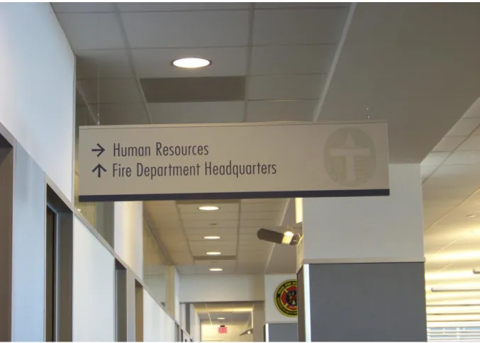
Figure 1: Building directory, an example of orientation sign ... 35
Figure 2: An example of directional sign ... 36
Figure 3: Examples of identification signs ... 37
Figure 4: Dimension of text height ... 38
Figure 5: The cone of vision of pedestrians... 39
Figure 6: The placement of signs ... 40
Figure 7: Surface color of signs ... 41
Figure 8: The components of academic library ... 46
Figure 9: Flow chart for the process of the study ... 56
Figure 10: Basement floor plan ... 88
Figure 11: Ground floor plan ... 89
Figure 12: Second floor plan ... 89
Figure 13: View from entrance of library... 90
Figure 14: Orientation signs at ground floor ... 91
Figure 15: The bridge between A block and B block ... 92
Figure 16: Orientation signs at first floor ... 93
Figure 17: Directional signs at first floor ... 94
Figure 18: Identification signs at ground floor ... 95
Figure 19: Directional signs at basement floor ... 96
Figure 20: The questionnaire ... 100
13
CHAPTER 1
INTRODUCTION
People make a picture of different routes in their mind to plan how to get from one place to another. It can vary from person to person and it is related with navigational strategies. Navigation is a main functional requirement for people to arrive in either familiar or unfamiliar environment. Navigation depends on updating one’s location and orientation with respect to the environment. Bell and Salvier (2004) indicated that navigation is a complex crucial problem that is usually met and solved by humans and other animals. Navigation is a coordinated and directed movement through a space
(Mantollo & Freundschuh, 2005). It consists of two parts which are travel and wayfinding. Mantollo and Freundschuh (2005) explain these two notions that whereas travel is the actual motion from the current location, wayfinding indicate to the cognitive coordination to the distant environment and contain activities such as planning and route choice.
14
The cognitive element of navigation is called wayfinding, which is important to any environment that claims movement over large scale (Darken &
Peterson, 2001). On the other hand, wayfinding can start to analyze in small scale. Going to work or school, walking through buildings and returning back home could be accepted by navigation in daily routine. While people realize these activities, they use their knowledge and previous experience to find their way in the environment; these routine activities are an unconscious process (Doğu, 2001).
The goal of wayfinding design is to provide the information required for users to correctly make and execute decisions within the environment (Passini, 1984). People require information to make the accurate decision on a route thus they find their way to a desired destination. With the help of
environmental design elements like layout, landmarks, signage and color, people reach where they want to go. In large scale built environments, wayfinding becomes a significant design issue because it can be difficult to find the way and go through from place to another place. In this situation, visual accessibility, architectural differentiation, building plan configuration are accepted to affect wayfinding decision (Doğu, 2001).
Wayfinding research is done in large and complex buildings such as
municipal buildings (Best, 1970), hospitals (Başkaya, 2004), shopping mall (Doğu,& Erkip, 2000), airports (Seidel, 1982; Churchill, Dada; de Barros & Wirasinghe, 2009), public libraries (Beecher, 2004; Mandel, 2013).Libraries
15
may be evaluated in large, complex built environments like shopping malls, hospitals, airports and public buildings. In all of these facilities, people go into the facilities to carry out specific needs. Signs are tools that aid in wayfinding. According to O’neill (1991), signage is used to enhance wayfinding efficiency especially in setting with complex floor plan configuration in which wayfinding is a serious problem such as subways, hospital and large governmental buildings.
Downs (1979) identified that library is an architectural maze where improved wayfinding can increase the effectiveness, frequency and volume of use and therefore should be considered when arranging interior spaces. In past researches, wayfinding has been studied generally in libraries and public libraries were used as a task. Public library users may differ from academic library users in important ways, such as being a more heterogeneous population comprised of people of varying ages and educational
backgrounds (Mandel, 2013). Literature about library signage has highlighted that wayfinding behavior for library users in entry area of public library facility (Mandel, 2013); the impact of signs on the success of library users in locating (Eaton, Vacino & Taylor, 1992); a comprehensive signage audit for best guidelines (Stemper & Polger, 2013). In this thesis, the relationship between utilized signs and familiarity with regards to wayfinding performance was mentioned.
16 1.1. Aim of the Study
The main purpose of this study is to investigate the relationship between utilized signage types with familiarity and confidence of cognitive map in academic libraries. Besides, it is to understand the influence of utilized signs on wayfinding performance with regards to familiarity and confidence. Signs seem helpful an adequate detail to direct people from place to place. Also some directors may be helpful and enabling people to reach the goal without error and hesitation. In this thesis, what types of signs are utilized was
investigated and the relationship between signage types with familiarity and confidence was searched with regards to wrong turns, hesitations and time spent in academic libraries.
The findings of the study may provide guidelines how signs can be altered to improve facilitate better wayfinding in case study building that is Bilkent University Main Campus Library. Besides, the findings may help not only architects, interior architects but also sign makers, educators and building directors who may influence the accurate wayfinding cues for library users.
1.2. Structure of the Thesis
The thesis consists of five chapters. The first chapter is introduction. An aim of the study is mentioned. The definition of wayfinding is stated generally. Also, the importance of wayfinding is touched on. One of the important tools,
17
signage, are mentioned in terms of its relation to building types and the importance of wayfinding.
The second chapter examines the concept of cognition. First of all, cognition was mentioned as definition and spatial knowledge is defined because it is important how people acquire, store, organize and recall a location’s of information, distance and arrangements in building (Gifford, 2002). Secondly, to understand spatial knowledge accurately, types of spatial knowledge that are landmark, route and survey knowledge was identified.
The third chapter consists of wayfinding. Its process and requirements are stated in order to understand the importance of wayfinding in human activities and psychology. General factors affecting wayfinding which are physical and psychological characteristics are stated. This study analyzes the wayfinding performances; in order to have better results, performances
criteria are explained. Besides, the effects of familiarity are discussed. Finally, Signage system is mentioned in this chapter. To understand which types of signs help to reach destination easily, signage types are defined. Besides, literature shows that in complex buildings, signs are problematic and when people navigate the built environment and strive or become lost, they feel frustration, stress and anxious (Arthur & Passini, 1992). In order to prevent these types of situation, signs are important tools. Although they are arranged in built environment, people have trouble with sign. In this chapter,
18
also why people have trouble with signs are explained. Finally, due to the goal of this thesis, library building is described with the example of literature.
The fourth chapter includes the experiment of the study. The aim of the study, research questions, and hypothesis are described. The methodology of the experiment is defined with description of the selected library building. The identification of sample group and explanation of the experiment
procedure are mentioned. Finally, the results are statically analyzed and evaluated.
Chapter five is conclusion part. In this chapter, a summary about thesis is written and it is mentioned about the limitation of the study. Besides, finally what will be done in future study is suggested.
19
CHAPTER 2
SPATIAL COGNITION
2.1. Definition of Cognition
People interact within the environment to get to the destination they want to go. During this action, they gain spatial cognition (knowledge) about their own movements and about spatial relations with the environment (Montello, Hegarty, Richardson & Weller, 2004). How people acquire, store, organize and recall information about location, distances and arrangements in
building, streets and great outdoor is called spatial cognition (Gifford, 2002). Therefore, it can be understood that spatial cognition has an important role to adapt to the environment and easy navigate (Kaplan, 1983). There are
different spatial cognition measurements techniques that include sketch maps, model constructions or manipulation, distance estimation, virtual environments and naturalistic observation in mazes or everyday settings. It also includes cognitive maps which are pictorial and semantic images in people’s heads related to how places are arranged (Kitchin, 1994). Cognitive processing also varies from one person to the next. Cognitive maps assist people for overcoming spatial problems such as how to deduce the way from one place to another when people have directly travelled the route and where to find requisite resources of all kinds. Cognitive map is described as a
20
mental portrait or set of representation of the spatial layout of the
environment (Montello and Freundschuh, 2005). Allen (2000) identified as ‘’ integrated of relationship among spaces’’. Cognitive maps are not tools for conscious planning; they are a template that helps people in making short term predictions like where we are going (Golledge, 1999).
It is important to understand difference between perception and cognition. Arthur and Passini (1992) explain these notions. Whereas perception is the process of achieving information through the senses; cognition is defined as understanding and being able to manipulate information. Spatial cognition is also affected by many factors which are personality, intelligence,
self-efficacy, culture, education, emotion, time pressure, risk, interest,
testosterone level, level of economic development (Gifford, 2000). Besides, signs and numbering systems, visibility of the destination, differentiation, and configuration influence spatial cognition and wayfinding (Weisman, 1981).
2.2. Types of Spatial Knowledge
In order to understand spatial cognition, we should describe three types of environmental knowledge, which are landmark, route and survey knowledge (Parush & Berman, 2004).
Landmark knowledge: Schlender, Peter and Wienhöfer (2000) stated that
21
an environment. ‘’It involves apparent objects to orient easily in a new environment (Edwards, Thompson & Barfield, 2000, p.13).’’ It does not involve spatial information; it plays an important role in route knowledge by specifying decision points (Sancaktar, 2006). It also provides remembering information (Edward et al., 2000).
Route Knowledge: It is also called as procedural knowledge. It is defined as
an inner appearance of the procedures needed for finding one’s way from place to place (Montello et al., 2004, p.270).’’ It is related with person’s capability to navigate from one location to another. It occurs an information about the order landmarks and minimal information about the appropriate action (Montello, 1998). Route knowledge has a greater impact on wayfinding performance compared to survey knowledge (Hölscher, Merlinger,
Vrachliotis, Brösame & Knauff, 2007).
Survey knowledge: It is gained when routes and landmark are combined
into a cognitive map. Van Dijk, op Den Akker, Nijholt and Zwiers (2003) identified survey knowledge as the ability to conceptualize the space as a whole. Survey representations facilitate spatial influences that can be useful during wayfinding through large spaces (Infield, 1991). Survey knowledge is not equivalent to wayfinding performance and a clear superiority of familiar people with respect to survey knowledge could be established (Hölscher, et al., 2007). The ability to use survey knowledge is referred to sense of
22
good sense of direction find out and attend to details in new environment and remember new routes better than people who have a poor sense of direction (Padgitt & Hund, 2012). On the other hand, people who have a poor sense of direction are more likely to lose their way and worry about learning becoming lost (Sholl, Acacio, Marker & Leon, 2000).
23
CHAPTER 3
WAYFINDING
3.1. Definition of Wayfinding
The term wayfinding was first used by Kevin Lynch in his effective book ‘The Image of the City (1960) to explain people’s orientation patterns in a city. Wayfinding is a movement which needs complete involvement with the environment (Passini, 1984) and it is the process finding a destination, whether in familiar or unfamiliar environments (Arthur & Passini, 1992). Lynch suggests fundamental ideas for wayfinding and realizing the city by forming mental maps consisting of paths, edges, landmarks, and nodes and district. Paths were defined as ‘the channels along which the observer customarily, occasionally and potentially by Lynch (1960). Passini (1984) states that corridors, promenades, walk on galleries are equivalent at the building scale. Edges were defined as the boundaries between two areas, the equivalent points at the building scale are walls. Landmarks were
identified as a type of point references, a defined object: building, signs, store or mountain (Lynch, 1960). Also, landmarks are often noticed and
socio-24
cultural significance (Doğu, 2002). At building scale, shops, bars, cinemas, information booths, sculptures, structural and decorative elements may be examples of landmarks. Landmarks function as sub-goals to provide people connection to the point of origin and destination during wayfinding path
(Allen, 2000) and they help people build a visual mode of environment (Toms & Denis, 2004). Padgitt and Hund (2012) stated that landmark can be points of a route where a choice required to which direction to proceed of a route where no decision needs to be made. Nodes were defined as points of intensive activity (Lynch, 1960). The equivalent points at the building scale are circulation intersections, halls and indoor squares. Districts addresses as medium to large sections of the city, conceived of as having a two
dimensional scope that are noticeable as having some common describing character (Lynch, 1960). Changes in function and floor numbers may be suitable example at building scale. If five elements are taken out from the environment and gotten used to compose a cognitive map of a building, spatial conceptions should be emphasized. In order to do this, legibility should be increased (Passini, 1984). Ramadier and Moser (1998) stated that when legibility is just evaluated as a spatial or functional form, it fails to include the impact of social meaning on spatial cognition. In addition, Doğu (2002) stated that familiarity is a significant contributing influence that may clear on how and why some aspects of environments are recalled easily and some are not.
Lynch explored how the differential feature of an urban space influenced people and physical features in it. Lots of works were done and new
25
definitions were composed for in built environment, also the knowledge about wayfinding was broadened. Weisman (1981) enhanced four categories of environmental factors thought to be impressive on wayfinding. Familiar cues for visual access or landmarks are first factors of these categories. Second can be said the architectural differentiation level among varied areas of a building that can assist remembrance and orientation. Third is the use of signs and room numbers to supply identification or directional information. Last one is the configuration of building which influences the case with which one can realized the overall layout of the building.
.
Arthur and Passini (1992) argue that wayfinding is a spatial problem solving activity that involves three ways which are making a decision, executing a decision and processing information. Decision making in wayfinding is the period of deciding with path to traverse when faced with series of alternatives (Xia, Arrowsmith, Jackson & Cartwright, 2008). Whereas making a decision is the development of a floor plan, executing a decision converts the plan into proper behavior at that space and processing information realize in its
generic sense as containing environmental perception and cognition.
3.1.1. Strategies of Wayfinding
The aim of wayfinding design is to provide the information for people to
correctly make and execute decisions within the environment (Passini, 1984). In the forthcoming years, Arthur and Passini (1992) explain that wayfinding
26
design purposes to plan the appropriate circulation system and stage interior design in order that elements allow to easy wayfinding.
Wayfinding involves two strategies which are route and survey strategy (Hund & Gill, 2014). Route strategy includes adopting main perspective such that the point of view creates from people. In route strategy, locations are identified using description like left, right, front, back. Hund and Gill (2014) described the definition with an example that to get café; take a left at the gas station and go straight. The café will be on the right. Daniel, Tom, Manghi and Denis (2003) stated that route cues are effective in terms of preference rating and achievement in finding destination. Survey strategy includes adopting a fixed references frame using the surrounding environment (Allen, 2000; Taylor & Tversky, 1996). In survey strategy, locations are identified with cardinal descriptions like north, south, east or west and distances. Hund and Gill (2014) explained it with an example that to get to the café, turn west at the gas station; travel 25m, the café is on the north side of the road. Chai and Jacobs (2009) found that when people use a survey strategy, they have better wayfinding performance during directional wayfinding task also Hund and Minarik (2008) stated that survey descriptors caused to more effective wayfinding such as faster times and fewer errors than route descriptors. On the other hand, Allen (2000) found that when using route description, people committed fewer errors and Denis (1999) stated that people who follow directions with using route cues, they did fewer errors than people who followed directions containing fewer of these cues. Besides, route cues have
27
higher effectiveness rating, faster and accurate wayfinding and fewer errors than did survey cues (Hund & Gill, 2014).
3.2. Factors Affecting Wayfinding Behavior
3.2.1. Physical Factors
Environmental factors affect wayfinding. ‘’Environmental information plays a central role in the conceptualization of wayfinding; it is fundamental in the making of decisions and decisions plan as well as in their execution (Doğu, 2002, p. 25)’’. It includes architectural, audible and graphic expressions that provide the essential information for wayfinding (Arthur & Passini, 1992). According to Weisman (1981), there are four categories to identify spatial factors that affect wayfinding. These are the ability to see through or out of a setting; types of signage provided; the extension one location looks different from others; the overall plan or layout of a setting. Also, Doğu (2002) has categorized environmental information in four headings in her study that architectural information is involved or inherent in the built environment; a building shape or layout may be difficult or easy to read; general information about building tenant, directions in a building and the identification of
destinations may be collected under a heading as graphic information; verbal information includes the kind of information that it can be transmit to passer-by, security guards and occupants. In this study, to have reliable
assessment, environmental factors should be analyzed with the subheadings which are visual accessibility, building configuration and architectural
28
Visual Accessibility: When buildings become larger, architectural obstacle
arises. The reason for this is complexity of spatial organizations, obstacles preventing visual accessibility. Visual accessibility is important factor in wayfinding because it provides people information about the circulation system, the horizontal and vertical paths, spaces adjacent to these paths (Doğu, 2002). If visual information becomes easily accessible, the legibility of the space is enhanced. Legibility is the apparent clarity of the environment and it is one of the significant concepts of environmental psychology and is important for environmental setting (Lynch, 1960). According to Garling (1983), a low visual access situation was created by artificially restricting participants’ vision. The visual access group learned significantly more slowly than people with visual access. Visual accessibility may provide information about the physical accessibility of a space as well as continuity and transition of the circulation system. Doğu (2002) has given an example about this statement to understand; luminous openings that give clues about a space which can be perceived from a relatively darker space may become mystical if it is not directly accessible but that circulation system allows the people with information just enough to reach it .
Building Configuration: It is important in wayfinding and understanding of
configuration is often the final development stage of learning of settings (Peponis, Zimring, & Choi, 1990). Weisman (1981) founded that the
building’s plan configuration, the ease and accuracy which one can create a mental image of it has some significant effect on wayfinding behavior. In later years Passini (1984) states that the comprehension of the principle by which
29
spaces are organized appears as the significant factor in simplification image formation of a building.
Plain and organized getting may reduce wayfinding problems with spaces to make easy predications. In complex settings, people are compressed with stimulation of all kinds of information and so finding relevant information becomes difficult (Arthur & Passini, 1992). Peponis et al. (1990) and O'neill (1991) also suggest that the complexity of a floor plan configuration is the primary influence on wayfinding performance negatively, when plan
complexity was increased, errors were also increased. Bronzaft and Dobrow (1984) claimed that simplicity and regularity of floor plans assist people in learning about layout of a setting. But, getting lost in spaces that are too much alike is common and similar spaces are hard to differentiate. On the other hand, O’Neill (1991) found that even with increases in floor plan complexity, people have big problems with realizing spatial layout and diminished wayfinding performances. That is, the complexity of a floor plan forms affect wayfinding performance negatively.
Besides, a significant predictor of wayfinding is building configuration that contains spatial content such as organization of floor plan configuration and circulation system. The architectural expression of the circulation system makes a building easier to understand. Arthur and Passini (1992) assert that a building created around an open core have the profit of providing entry to the form of the circulation system for people. It makes a building easier to understand so a person perceiving a well-articulated building is in possession
30
of precious wayfinding information. In addition to these, Abu-Obeid (1998) claim that symmetric and continuous rectilinear floor plans that are called as gestalt way of thinking that are decent forms to remember easily and which are believed to relieve forming cognitive maps and to assist people's
orientation. The building configuration and circulation system of the building, scale has a significant influence in understanding a space. It is an important factor in the gain of spatial knowledge.
Architectural differentiation: It also becomes an important factor that
affects wayfinding positively and negatively. Arthur and Passini (1992) state that using color, material and texture differences in spatial features such as structures above or below paths articulate the building organization. In architecture, a certain degree of environmental complexity is required
because even if being simple, repetitive elements in architectural composition is factor that creates difficulty because of their repeated sameness (Passini 1996).
3.2.2. Psychological Factors
Psychological factors may be included individual differences such as gender, age, educational, occupational and cultural differences; they should directly or indirectly influence wayfinding (Xia et al., 2008). Gender, age and
familiarity have been examined in previous studies. Gender is a significant factor which affects the use of architectural and graphical elements and so wayfinding process is influenced because of this. There are some studies to
31
examine the importance and differences in gender in wayfinding. Lawton (1996) reported that men were importantly more accurate than women when indicating the direction of the destination. Cornell, Sorenson and Mio (2003) said that males tent to express more confidence in spatial abilities when compared females. Besides, performances of females were poor in
wayfinding tasks and they were slower than male in estimation of bearing. According to Schmitz (1999), men were more talented in recalled route directions in maps and description than women but they were weak in the use of landmarks to route direction in comparison to women (Allen, 1999). In addition, time spent has some differentiation between female and male for finding their way and they found less wayfinding points than male participants did.
Age is the other factor influence architectural and graphical elements. Cubukcu and Nasar (2005) state that age produced a significant effect on navigation errors. That is; age increased, performance declined. Galea and Kimura (1993) found that younger people scored higher than adults did not only on landmark selection but also on scene recognition, distance ranking, map placement and route execution task.
3.3. Wayfinding Performance Criteria
To obtain quantitative data, wayfinding performance criteria are significant issue by measuring wayfinding performance consistently. There are three levels of metric for evaluating wayfinding. These are users’ task performance
32
like time spent, distances and number of errors made), physical behavior (looking around, classification of time and error), decision making which is think aloud, interview, and questionnaire (Ruddle & Lessels, 2006).
According to the suggestion of Ruddle and Lessels (2006), these levels are used for wayfinding performance in order to measure the contribution of signage types on wayfinding performance in this study. Wayfinding
performance was measured through dependent variables: time spent, the number of errors, hesitation, rate of travel and backtracking during wayfinding tasks. Similar measures have been used in other studies (Carpmen, Grant, & Simmons, 1984; Weisman, 1981; O’neill, 1991; Helvacıoğlu, 2007; Kumoğlu, 2013). The classifications of measurements are explained at below.
Wayfinding is the ability to reach a destination in short time without
experiencing fear and stress (Peponis et al., 1990). Therefore, time spent is the important factor for measurement of wayfinding performances. Coluccia and Iasue (2004) examined that wayfinding time is correlated with error (wrong turns) and hesitation frequencies. People who made more errors and hesitations spend more time to reach a destination. Additionally, the number
of errors is frequently used as a measure of performance. Ruddle and
Peruch (2004) explain that the type of error that is most commonly identified in wayfind a miss, which happens when a user moves within view of a given location without turning to look at it or takes a wrong turn. Also, decision
points are related with route between a main and a desired destination
(Golledge, 1999). According to Raubal and Egenhofer (1998), if people choose a long route, the number of decision point’s increase and that
33
influence the inconvenience of wayfinding task. Best (1970), and Arthur & Passini indicate that the number of decision points affects a wayfinding task performance. That is, it can be said that the more choice points, the more likely the respondent was to report becoming lost. Besides, hesitation is also used a performance measurement. The number of full stops is defined as hesitation (Devlin & Bernstain, 1998; Lawton et al., 1996; Raubal &
Egenhofer, 1998; 2006; Helvacıoğlu & Olguntürk, 2011). Whereas rate of travel is defined as a measurement in feet per second; backtracking is defined as a retracking of a path in the opposite direction of how it was first travelled (O’neill, 1991).
3.4. Signage Systems
Signs are an important element in wayfinding. They tell people what is, where and when they refer to an event and also specify when and how likely it is to occur. Sigs can be composed of any sorts of graphics or text for providing information for the users. O’Neill (1991) claimed that signage is used to enhance wayfinding efficiency especially in setting with complex floor plan configuration where wayfinding is a chronic problem such as subways, hospitals and large governmental buildings. Also, it can be said that signage systems include visual information systems that use graphic and letters to communicate environmental information with regard to direction,
identification, safety and regulations (Colori & Vonden-Eynden, 2015) to specific groups, providing safe and walking experience (Zhang, Jia & Qin, 2016).
34
Graphic information is utilized as communicator and help visitors to orient themselves in spaces. O’Neill (1991) found that when people use textual signage, they have the fewest number of wrong turns. Where people use graphic signage, they have significantly small number of wrong turns and if people do not utilize signage, they have lots of wrong turns.
3.4.1. Signage Types and Their Functions
There are various types of signage. These provide to individuals for reducing the risk of disorientation and for helping them understanding the environment (Bourdeau & Chebat, 2003). Signs whether exterior or interior have three functions which directly correspond to the functional information types there are orientation, directional and identification signs (Arthur & Passini, 1992).
Orientation signs: ‘’They give users an overview of what 'shape' the
building has, where they are, and where the destination lies, as well as other relevant information about the general setting (Arthur and Passini, 1992, p. 143).’’ Maps, floor plans, exploded views and models, all with you are here map, clearly identifying corridors, destination zones and building directories rank as examples of this signage type (see Figure: 1).
35
Figure 1: Building directory, an example of orientation sign
https://www.pinterest.com/pin/6122149471259222/
Directional signs: ‘’They are the common process description. They give
information about a destination to lead people along a determined route (Arthur & Passini, 1992, p. 143).’’ Mostly directional signs include arrows and elevator button panels (Giuliani, 2001, p. 50). Also, Arthur and Passini gave floor directories in elevator lobbies as an example of directional signs (see Figure: 2). They are used for showing people which way they need to go (Miller & Lewis, 1999). Arrows that are placed too far from the text they refer to reduce the effectiveness of directional signs.
36
Figure 2: An example of directional sign
http://shriadvertising.com/
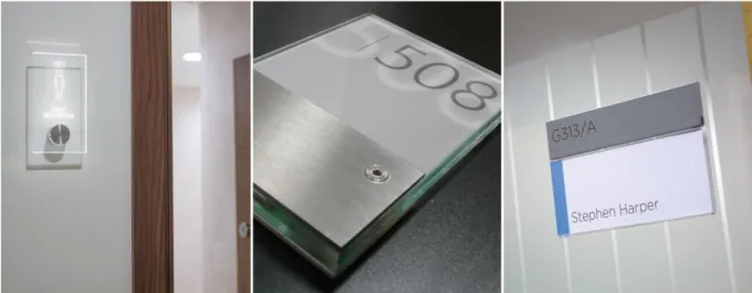
Identification signs: Passini (1984) state that identification signs are the
most significant state explanation of location. They provide information about the destination. They involve building signage, floor numbers and room identifiers provided at the destination (see Figure 3). These signs only used when destination is reached. That is; these kinds of signs tell people where they are and where they have arrived at their destination (Miller & Lewis, 1999).
37
Figure 3: Examples of identification signs
https://www.signbox.co.uk/interior/room
3.4.2. Regulations of Signs
Basic international guidelines and standards have indicated the principles and criteria of designing and locating signs to provide that signage system is legible, nonerasable and intelligible (Coté, 2011; Ministry of Public Security of the People’s Republic of China, 2008; Ministry of Public Security of the
People’s Republic of China, 2005; British Standards Institution, 1990). The decision of providing either graphic or textual signs should be done through planning signage.
Content of signs: According to Signage Design Guidelines (2009), signage
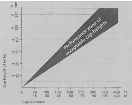
should be less; text should be concise to read easily on the move; pictures and graphic should speak volumes; the use of signage both pictures and graphics hierarchy should be achieved consistently. Also, Janet and Mayron (1993) stated that the characters of signage text styles must be sans serif or
38
sample serif; letters must be between 1.5cm and 5cm in height (see Figure 4). The content of the signage should be considered because of the
remembrance of signs. When the number of word increase, the level of remembrance of signs decrease (Bourdeau & Chebat, 2003). Long horizontal signs should not use. Mclean (1993) claims that 40-50 characters start to distract visitor attention, disturb eye and tend to lose place. Signs should not be more than five messages and five lines of text in a single character height, stroke width font type; surface characteristics should be considered (Pollett & Haskell, 1979).
Figure 4: Dimension of text height
derived from Way-finding: People, Signs and Architecture
Location of signs: Arthur and Passini (1992) categorized the construction a
sign in three ways: self-supporting on a post, a slab; wall mounted flat on vertical surface and suspended from a soffit or ceiling. Transitional and
39
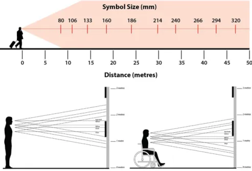
intersection areas are appropriate for location of signs in terms of visibility (Pollet & Haskell, 1979). Arthur and Passini (1992) stated that decision points show themselves as corridor intersections because this provide maximum visibility of the information for people coming from all directions especially in complex buildings like hospitals or university buildings. The signage visibility is rest upon the distance between the pedestrian and the signage; longer viewing distances prevent intersections between the signage and the pedestrian (Wang, Lo, Lui, & Kuang, 2014; Nassar, 2011). The visible distance of signage is related with its height, size (Garvey, Pietrucha, & Meeker, 1997), color ( Wong & Lo, 2007) and viewing angle (Xie et al., 2007) and is influenced by pedestrian age (Chrysler et al., 2001), vision level (Scott, Atkins, Bentzen, & Barlow, 2012) and obstacles (Zhang et al., 2016) (see Figure 5). Rousek (2011) state that eye level signs could attract the attention of users more frequently.
Figure 5: The cone of vision of pedestrians
40
Graphic information in horizontal should be located 1200mm above from the floor due to the cone of vision of pedestrians, children, adults and people with wheelchair (Arthur & Passini, 1992). Also they states that the display of large pictographs has been placed above door height 2200mm and extending ceiling height 3000mm in order to utilize from display (Arthur & Passini, 1992) (see Figure 6).
41
Derived from Way-finding: People, Signs and Architecture
The finishing of signage: It should be involved that letters should have an
eggshell, matte or other non-glare finish. Also, letters of texts should have a minimum 70 percent reflectance contrast with their background and can be either light character on dark background or dark characters on a light background (Janet & Myron, 1993, p.82) (see figure 7).
Figure 7: Surface color of signs
http://onlineincometeacher.com/tips/typography-tips/
3.4.3. The Reasons of Problems on Signs
Inaccurate, incoherent and invisible signs create problems on wayfinding in unfamiliar environments. Arthur and Passini (1992) explain why people have trouble with signage. The reasons of problems of signs were explained at below:
42
Ambiguity: Even if a message might be clear for person who originally put
the sign up, it may be unclear; it causes ambiguity.
Conflict: Two close signs to each other create also difficulties. This situation
is faced when new signs are installed and old ones are not taken; so it creates conflict. Deficiency: It creates a problem with little information. Signs should contain information that people need at particular places.
Confusion: When more data which are provided at given decision points, confusion is faced. If signs are well illuminated, they are much more efficient;
therefore, signs should place opposite windows.
Illegible: Messages that are illegible are too small to be seen from the
reading distance of sign, even if there may be nothing wrong with the
message. Signs should give the right information. Finally, people should give full orientation to the wayfinding task because if it is not provided, they may miss important information, signs, landmarks and architectural feature.
3.5. Familiarity and Wayfinding
Familiarity is one of the crucial factors affecting wayfinding process. It influences improvement of sense of direction and wayfinding ability. O'neill (1992) states that as familiarity with an environment increases, wayfinding performance improve and the degree of complexity of the layout becomes less important. Familiarity also affects the spatial orientation. People who are familiar to the environment used more information stored in their long term memory, asked less help for wayfinding and used fewer maps, but people
43
who are unfamiliar used external sources more like maps, signs and other people( Chebat, Chebat &Therrien, 2005). Spatial orientation is related with wayfinding. Passini (1996) explains the difference between spatial orientation and wayfinding: ‘’spatial orientation is about the ability of people to reflect the spatial characteristics of a setting and to position him or herself thin that representation (p. 321).’’ ‘’Wayfinding is broader as it involves all the mental process which is included in purposeful mobility (p. 322).’’ If people cannot place themselves and cannot enhance a plan to arrive the destination, they tend to feel disorientation. The wayfinding activity can be investigated as a continuous sequence of problem solving tasks requiring information about the environment (Passini, 1984). Garling, Lindberg and Mantyla (1983) point out that familiarity with a building has crucial impact on wayfinding behavior. People who are familiar with the building rely on their knowledge and they walked on completely planned route; also they navigate faster than unfamiliar people taking the same route (Hölscher et al., 2007). Besides, people with their knowledge did not gather as much as information from their
environment as unfamiliar people who are obliged to search and look at signs (Hölscher et al., 2007).
44 3.6. Wayfinding in Libraries
Libraries are more complex areas than being simple areas; they also include human conception and imagination (Leckie & Buschman, 2007). According to these definitions, libraries are important places because they provide social interactions and maintain privacy for people.
3.6.1. Library as a Place
A library as a place has been consulting to people in the way libraries have long been centers of social and cultural activities and also information and learning (Kim, 2016). The definition of library in Association of Research Libraries (2008) is explained the physical environment of the library as community place for individual or group work and inspiration; comfortable and inviting location.
The perception of user of the library building has inference for the effective design of library space (Kim, 2016). Beecher (2004) stated that the user of public library that they have people to utilize from different ages, background and education levels. Academic libraries may be different from academic libraries in terms of the perception of users. There is limited research on the perception of academic libraries. Academic libraries have faced the need to inform people about changes in the campus. Academic libraries are also identified, like public libraries, as an information and services place and they serve as place to socialize, relax in campus (Kim, 2016). They are also
45
community centers in addition to their traditional role as academic centers. They have important role for academic and social activities in academic institutions.
The common activity of academic library is seeking information and it involves information resources and effective services (Peterson, 2005). There are some determined items on the element of academic library as place based on previous researches (Demans, 2005; Shill & Tanner, 2004; Waxman, 2007; Weise, 2004). They were compiled under the parts which are physical setting of place includes the exterior-interior of the building, books and print materials, individual group study space, space for reading-digital information-library services, outdoor seating, computer and wireless
connection, seminar rooms, café-lounge areas, exhibition spaces; the person of library involve staff, students at subsidiary facilities; events and workshops. These items were compiled at below Figure 8.
46
Figure 8: The components of academic library
3.6.1. Wayfinding in Library
Wayfinding is important for library building like hospitals, shopping malls, education and governmental buildings and airports. According to Downs (1979), developed wayfinding can increase the effectiveness, frequency and usage of library. Therefore, when arranging interior spaces of library, the statement of wayfinding should be considered. In library buildings, there are some studies about complexity, visibility and signage on library buildings.
47
O’neill (1991) stated that floor plan complexity increases, wayfinding performances decreases. Besides Li and Klippel (2012) connected this statement with familiarity and they found that if a building has a high complexity, people face difficulties regardless of their familiarity of the environment (Li & Klippel, 2012). When we looked at the relationship between library and wayfinding performance, Beecher (2004) defends that people’s wayfinding performance with access to signage in the complex building remained equivalent, or poorer than simple settings with n signage. Besides, O’neill (1991) found that graphic signage generates the greatest role of travel, but textual signage was the most effective in diminishing wayfinding errors like wrong turns and backtracking. In literature, it can be shown that directional signs help people for orientation and navigation; thus they might be more important to easing wayfinding than informational signs (Mandel, 2013) because directional signs should provide additional
information to the mental image of the area (Beecher, 2004). A review of literature of wayfinding in libraries demonstrated an emphasis of the signage; though there is brief mention of the effect of architecture also studies the location of items in an academic library. In this thesis, the relationship
between utilized signage and wayfinding performances in academic library as a task was investigated.
48
CHAPTER 4
THE STUDY
4.1. Aim of the Study
The main purpose of this study is to investigate the relationship between utilized signage types with familiarity and confidence of cognitive map in academic libraries. Besides, it is to understand the influence of utilized signs on wayfinding performance with regards to familiarity and confidence. Signs seem helpful an adequate detail to direct people from place to place. Also some directors may be helpful and enabling people to reach the goal without error and hesitation. In this thesis, what types of signs are utilized was
investigated and the relationship between signage types with familiarity and confidence was searched with regards to wrong turns, hesitations and time spent in academic libraries.
49 4.1.1. Research Questions
1. Is there a relationship between utilized types of signs and wayfinding performance in academic libraries?
2. Is there a relationship between signs and familiarity according to time spent, the number of errors and hesitations in academic libraries? 3. Is there a relationship between signs and confidence in cognitive map
of building according to wayfinding performance in academic libraries?
4.1.2. Hypothesis
1. The improvement of wayfinding performance is related with utilized signs in academic libraries.
2. Number of wrong turns decreases with increasing familiarity in academic libraries.
3. Hesitations turns decreases with increasing familiarity in academic libraries.
50 4.2. Method of the Study
4.2.1. Selecting the Destination
Library is a place where enhanced wayfinding increase the frequency and effectiveness of library use so it should be considered when arranging library interior spaces (Downs, 1979). According to results of previous works
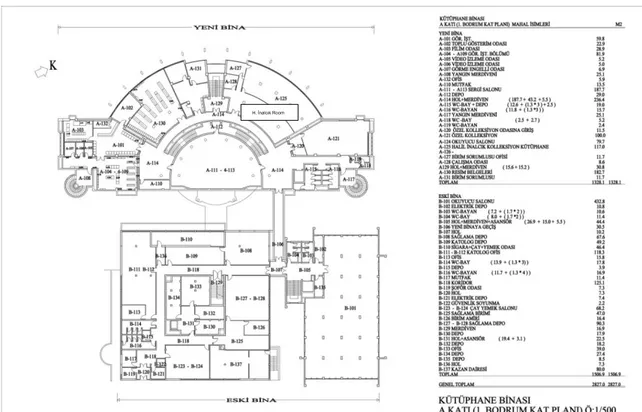
researches, public library and academic library may have some different approaches and results because of their user profiles. Based on this approach, in this study, an academic library which is located on Bilkent University main campus was selected as an experiment sample and Bilkent University Library building is a complex and large building (see Appendix A).
The library building is utilized by student and academic people of Bilkent University. A well-known building is located at main campus. The library is multi-storey large scale building. It has been designed by Erkut Şahinbaş. It consists of two blocks. First block which is called B Block or old building have also two parts. First part was built in 1987 and second one was built in 1992. Second block that is called A Block or new building was built in 1995. These two different main parts are connected together with a bridge and a gateway. Whereas a bridge stays on first floor, a gateway locates at basement floor. When the scale and the complexity of the building are taken into
consideration, perception of the building is gotten hard (O’neill, 1991; Arthur & Passini, 1992). The literature of wayfinding at library focuses on signage (Brown, 2002; Mallery & DeVore, 1982; Pollet & Haskell, 1979). In this study, the relationship between signage of library building and users’ wayfinding
51
performances was examined. In order to analyze the present study in better way, the signage system and signs of library will be mentioned at below.
In the library building, there are orientation, directional and identification signs to lead people where they want to go expect reading and studying areas. In library, orientation signs are faced in each floor. They are located on the stair exists (see Figure A2.2) and the bridge when passing from new building to old building (see Figure A2.4). Directional signs located intersections of hallway on floor by hanging from the ceiling (see Figure A2.5). Identification signs take place above the doors to specify the room number (see Figure A2.6). In the building, there is no you-are-here map but there is an
informational graphic involved the section of the building. This graphic located both at the entrance on a stand and computer screens all over the building. Orientation signs have dark characters on a light background; identification and directional signs have light character on a dark background in the library building (see Figure A2.2 and A2.5).
4.2.2. Sample
The sample was composed of graduate and undergraduate university students from Bilkent University. Seventy one students were chosen using convenience sampling. However, architecture students were excluded from the study because of their space perception ability (Gifford, 2002). There were 36 women, 34 men and one unspecified. The experiment was
52
routes. That is, people who followed or joined another person were more likely to navigate routes with five or more stops than people who navigate alone (Li & Klippel, 2012).
Table 1: Subjects' number according to their sex
Female Male Unspecified TOTAL
36 34 1 71
4.2.3. Questionnaire
In this study, a questionnaire was used as an instrument (see Appendix B1). The questionnaire was composed of 15 questions related with familiarity, use of library, use of signs and confidence level of cognitive maps. First four questions are related with the use of library building such as how long have you been using the library; how often do you use the library; how do you feel familiar with the library; how much time has passed since last use? These questions help to measure the familiarity. Question 5 is related with the level of findable the destination points which are Halil İnalcık Room and
Multimedia Room. Question 6-9 are related with the evaluation of signs in library building. Question 6 measures what is the level of assist of signs to reach rooms. Question 7 measures understandability of signs to reach rooms. Question 8 measures what is the level of assist of directional signs to reach rooms. Question 9 measures a density of signs to reach rooms. Five point likert scales is used to evaluate these questions. Question10 and 11
53
are related with types of signage and question 12-14 are prepared for evaluation of confidence level of cognitive map. These questions are
selected from previous study which was conducted by Weisman (1981) and was adapted to this study. Finally, last question is open ended which was interrogated signs according users’ opinions.
Before the study, a pilot study was done with 22 graduate and undergraduate students to check the comprehensibility of the adjectives, the
understandability of questions and the questionnaire form in general. Some questions were changed because of ambiguity of adjectives and some questions were also changed according to the aim of the study.
4.2.4. Procedure
Before the experiment, the plans of library were examined and destinations where located from different parts of library building. In determining
destinations, it was regarded that selected targets would have been far away from each other. There were determined two different destination points. Whereas one of them named ‘Halil İnalcık Collection Room’ was located at basement floor of A Block, other one named ‘Multimedia Room’ was located at second floor of B Block. The reasons why Halil İnalcık Collection Room were selected as one of the target are that directional signage are not sufficient and observations before the present experiment showed that this room is lesser known. On the contrary, according to the observations before the experiment, Multimedia Room is well known. Students utilize there
54
frequently. Despite this, signs which direct to this room are insufficient. Therefore, the reasons why Multimedia Room was selected as a target are being well known and have insufficient signage system.
55 4.2.4.1. The Experiment
For the experiment, three different days were selected. Both weekdays and weekends were selected to include different density situations. The first selected day was a weekday during classes; second day was a weekday after classes and third day was a weekend. On these days, no signs were altered; current states of signs were used. The experiment was continued during 15 days in March and April 2016.
The experiment was conducted in two phases. The first phase was to reach the destinations after completed the tour in library, participants filled out a questionnaire which has fifteen questions included personal information, familiarity, use of sign types and finally confidence and task performances.
Before beginning the experiment, a pilot study was done. The reason why the pilot study conducted was to understand the comprehensible destination and questionnaire. The pilot study was done with twenty two volunteer students who were undergraduate and graduate students from Bilkent University. They were selected using convenience sampling. According to the results of pilot study some questions in questionnaire were altered. In direction of pilot study, Weisman’s questionnaire (1981) was a resource of this present study. Questions about familiarity and confidence were used in the present study.
56
As mentioned above, the experiment was conducted in two parts. In the first part, the task was composed of convenience sampling and selected students started the entrance of library building. The aim of the study and tour
information was narrated by the researcher. After that, the tour was able to start. The sequence of the destinations and which route would be used was determined by the participants. During the tour, the researcher saw people to destination; however participants were requested not to ask question to the researcher. Within this time period, wrong turn – errors, hesitations, and time spent and the sequence of destinations were taken notes by the researcher to understand and evaluate relation between wayfinding, types of signs and performances.
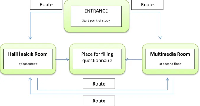
ENTRANCE
Start point of study
Halil İnalcık Room
at basement
Route Route
Route Route Place for filling
questionnaire
Multimedia Room
at second floor
Figure 9: Flow chart for the process of the study
57
The tour started at the library entrance and it ended after reach the two destinations points were reached. The mean tie for the completion of the tours was 237, 35 seconds for each participant. After completed the library tour, the second part of the experiment was started; fill the questionnaire.
58
CHAPTER 5
RESULTS
Statistical Package for the Social Sciences (SPSS) 22.0 was used to analyze the data. Frequency tables (see Appendix C), correlation tables, t-test and the one way analysis of variance F-test (ANOVA) was used to analyze the data.
5.1. Descriptive Statistics
According to the results, 71 graduate and undergraduate students from 14 departments participated in the study. Eighty percentages of participants reported using the library for more than one year. The frequency of library use reported by participants was 32.4% once a week; 29.6% once a month; 28.2%; and 7% were first time user. Besides, 34% of participants felt familiar to the library building.
59
In the evaluation of current signage according to the questionnaire, respondents reported that signs helped often in ratio of 43.7%. Signs that were used to reach room were found to be coherent in ratio of 39.4%. Also, signs often help to participants to find the rooms in ratio 39.4%. During the tour, density of signs was sufficient in ratio 40.8%. When evaluating the types of signage, the most widely used type is directional signage with the ratio of 69% (49 participants); orientation signs were used in ratio 53.5% (38 participants); identification signs were used in ratio 36.6% (26 participants). Also, building staff and picture on computer screens helped and orient people to find the rooms.
Types of signs and use of library were evaluated to understand their relations among each other in terms of familiarity. We see that 81.6% (31 participants) who have been using the library more than one year reported that they used orientation signs; 79.6 % (39 participants) that they used directional signs; 88.5% (23 participants) reported that they used identification signs (see Table 13 in Appendix C). When analyzed the relationship between types of signs and frequency of using the library, we see that 31.6% (12 participants) who have been using the library everyday reported that they used orientation sign; 22.4% (11 participants) of those reported that they used directional signs and 19.2% (% participants) use identification signs. Types of signs and level of familiarity were also evaluated to understand the relationship among each other. We see that 55.35 (21 participants) who feel familiar with the library reported that they are quite familiar to this building.
60
93% (66 participants) stated that they can direct people may places like rooms, stairs, exits… 62 % (44 participants) thought that to draw the layout of this building or corridors was hard and 76 % (54 people) could not ensure their own drawing (see Table 2).
Besides in the study, it can be seen that people preferred Halil İnalcık Room which was the closer at the start point than Multimedia Room in ratio 59.2%. Whereas 74.6% of participants found Halil İnalcık Room easily, 87.3% of those found Multimedia Room easily. Some of participants found both of them easily. We see that 86.8% of participants who easily found Halil İnalcık Room and 85.5% of participants who easily found Multimedia Room reported that reported that they have been used the library more than a year.
5.2. Statistics for The Relationship between Signage Types and Wayfinding Performances
For the first research question that utilized signs improve wayfinding performance in academic libraries, correlation analyses were done for the relationship between wayfinding performances criteria (the number of wrong turns, hesitations and time spent) and target rooms. After that the
relationship between the utilized types of signage during wayfinding task and wayfinding performance criteria were analyzed with t tests. According to correlations analysis for relationship between wrong turns and hesitation with