EXPLORING VERTICAL NAVIGATION WITHIN A VIRTUAL ENVIRONMENT: A STAIRCASE EXPERIENCE
A Ph.D. Dissertation
by
İPEK (SANCAKTAR) MEMİKOĞLU
Faculty of
Art, Design and Architecture İhsan Doğramacı Bilkent University
Ankara July 2012
EXPLORING VERTICAL NAVIGATION WITHIN A VIRTUAL ENVIRONMENT: A STAIRCASE EXPERIENCE
Graduate School of Economics and Social Sciences of
İhsan Doğramacı Bilkent University
by
İPEK (SANCAKTAR) MEMİKOĞLU
In Partial Fulfillment of the Requirements for the Degree of DOCTOR OF PHILOSOPHY
in
THE FACULTY OF
ART, DESIGN AND ARCHITECTURE İHSAN DOĞRAMACI BİLKENT UNIVERSITY
ANKARA July 2012
I certify that I have read this thesis and have found that it is fully adequate, in scope and in quality, as a thesis for the degree of Doctor of Philosophy in Art, Design and Architecture.
Prof. Dr. Halime Demirkan Supervisor
I certify that I have read this thesis and have found that it is fully adequate, in scope and in quality, as a thesis for the degree of Doctor of Philosophy in Art, Design and Architecture.
Assist. Prof. Dr. Nilgün Olguntürk Examining Committee Member
I certify that I have read this thesis and have found that it is fully adequate, in scope and in quality, as a thesis for the degree of Doctor of Philosophy in Art, Design and Architecture.
Assist. Prof. Dr. Yasemin Afacan Examining Committee Member
I certify that I have read this thesis and have found that it is fully adequate, in scope and in quality, as a thesis for the degree of Doctor of Philosophy in Art, Design and Architecture.
Assist. Prof. Dr. Ufuk Demirbaş Examining Committee Member
I certify that I have read this thesis and have found that it is fully adequate, in scope and in quality, as a thesis for the degree of Doctor of Philosophy in Art, Design and Architecture.
Assist. Prof. Dr. Osman Demirbaş Examining Committee Member
Approved by the Graduate School of Economics and Social Sciences
Prof. Dr. Erdal Erel Director
iii
ABSTRACT
EXPLORING VERTICAL NAVIGATION WITHIN A VIRTUAL ENVIRONMENT: A STAIRCASE EXPERIENCE
Memikoğlu, İpek
Ph.D. in Art, Design and Architecture Supervisor: Prof. Dr. Halime Demirkan
July, 2012
Architectural cues are configured by architects in the initial phase of design process. Local architectural cues within an environment can aid individuals during navigation and influence their spatial orientation. Staircases, as a feature of local architectural cues that provide access to the other floors in a multi-level building can have an impact on vertical navigation. This study focuses on the issue of vertical navigation during virtual navigation by integrating the individual characteristics and the
geometric attributes of a staircase pair within two different multi-level desktop virtual environments (VEs). The angle between the cue pairs with respect to the same observation point is altered in order to determine the staircase pair that is more efficient in navigation. Circulation paths, gender differences, navigational abilities and cue pairs are considered to be factors that affect staircase preferences for
ascending and descending. For the VE with a 180° difference between the cue pairs, there was a relationship between the ascending and descending staircases. Further analysis indicated that the staircase preference in ascending was either related to the first or last visited rooms on the ground floor. For the VE with a 90° difference between the cue pairs, no relationship was found between the ascending and descending staircases as well as with any other factor. There was no significant relationship between gender and staircase preference except for the descending staircase with 180° difference between the cue pairs and was in favor of females. In addition, there was no significant relationship between the navigational abilities and staircase preferences.
Keywords: Architectural Cues, Gender, Geometric Attributes, Staircases, Vertical Navigation, Virtual Environments
iv
ÖZET
SANAL ORTAMDA DİKEY NAVİGASYONUN İNCELENMESİ: BİR MERDİVEN DENEYİMİ
Memikoğlu, İpek
Doktora, Güzel Sanatlar, Tasarım ve Mimarlık Fakültesi Tez Yöneticisi: Prof. Dr. Halime Demirkan
Temmuz, 2012
Mimari işaretler, mimarlar tarafından tasarım sürecinin ilk aşamasında yapılandırılmaktadır. Lokal mimari işaretler, bireylerin mekan içinde
navigasyonlarına destek olarak, onların mekansal yönlendirmelerini etkiler. Lokal mimari işaretlerden biri olan merdivenler, çok-katlı bir binada diğer katlara erişim sağlamakta ve dikey dolaşım sürecini etkilemektedir. Bu çalışma sanal navigasyon sırasında, iki çok-katlı masaüstü sanal ortamda, bireysel özellikler ile bir çift merdivenin geometrik niteliklerini birleştirerek dikey navigasyon konusuna odaklanmaktadır. Navigasyon sırasında en etkin merdiven çiftini belirlemek için, sabit gözlem noktasına göre işaret çiftleri arasındaki açı farklılaştırılmıştır. Dolaşım şekli, cinsiyet farkı, navigasyon becerileri ve işaret çiftleri; merdivenlerdeki yukarıya çıkış ve aşağı iniş tercihlerini etkileyen faktörler olarak düşünülmüştür. Merdiven çiftleri arasında 180° fark olan sanal ortamda, yukarıya çıkış ve aşağı iniş
merdivenleri arasında bir ilişki bulunmuştur. İleri analizler, merdivendeki yukarıya çıkışın giriş katındaki ilk ya da son ziyaret edilen odaya göre tercih edildiğini göstermektedir. Merdiven çiftleri arasında 90° fark olan sanal ortamda, hem yukarıya çıkış ve aşağı iniş merdivenleri hem de başka faktörler arasında bir ilişki bulunamamıştır. Cinsiyet ve merdiven tercihleri arasında anlamlı bir ilişki bulunmamış olup, sadece bayanlar tarafından işaret çiftlerinin arasında 180° fark olan aşağı inen merdivende anlamlı bir ilişki bulunmuştur. Ayrıca, navigasyon becerileri ve merdiven tercihleri arasında anlamlı bir ilişki bulunmamıştır. Anahtar Sözcükler: Cinsiyet, Dikey Navigasyon, Geometrik Nitelikler,
v
ACKNOWLEDGEMENTS
I would like to thank Prof. Dr. Halime Demirkan for her invaluable supervision, guidance, patience and encouragement throughout the preparation of this thesis. It has been a pleasure to be her student and to work with her.
I express appreciation to Assoc. Prof. Dr. Feyzan Erkip and Assist. Prof. Dr. Ufuk Demirbaş for their helpful suggestions. I would like to thank Assist. Prof. Dr. Nilgün Olguntürk, Assist. Prof. Dr. Osman Demirbaş and Assist. Prof. Dr. Yasemin Afacan for their comments.
I would like to thank İnci Cantimur for her help in the preparation of the virtual environments and Elif (Helvacıoğlu) Güneş for her moral support and friendship. In addition, I am grateful to my family for their invaluable support, trust and
encouragement throughout the preparation of this thesis. Finally, I owe special thanks to my husband Osman Memikoğlu for his incredible support, encouragement, patience and love. Without him this thesis would not become what it is.
vi
TABLE OF CONTENTS
ABSTRACT... iii ÖZET ... iv ACKNOWLEDGEMENTS ... v TABLE OF CONTENTS... vi LIST OF TABLES ... x LIST OF FIGURES ... xi CHAPTER 1: INTRODUCTION... 11.1 Aim of the Study... 3
1.2 Structure of the Thesis ... 4
CHAPTER 2: VIRTUAL ENVIRONMENTS (VEs) ... 6
2.1 Navigation... 7
2.1.1 Travel Techniques ... 10
2.1.2 Navigation Strategies... 17
2.2 Frames of Reference ... 18
2.3 Architectural Cues ... 20
2.3.1 Global Architectural Cues ... 22
2.3.2 Local Architectural Cues ... 23
vii
CHAPTER 3: INDIVIDUAL DIFFERENCES IN VEs... 28
3.1 Gender Differences ... 28 3.2 Sense of Direction... 32 3.3 Sense of Presence... 36 3.4 Previous Experience ... 41 3.4.1 Computer Games ... 41 3.4.2 Computer Familiarity ... 45 CHAPTER 4: METHODOLOGY ... 49
4.1 Aim of the Study... 49
4.2 Research Questions... 50
4.3 Hypotheses... 51
4.4 The Proposed Model... 52
4.4.1 Participant... 55
4.4.2 Virtual Environment ... 55
4.5 Instruments and Software ... 57
4.5.1 Santa Barbara Sense of Direction Scale (SBSOD)... 57
4.5.2 Computer Aversion, Attitudes and Familiarity Index (CAAFI) ... 57
4.5.3 Igroup Presence Questionnaire (IPQ)... 58
4.5.4 Observation Sheet and Computer Experience Questionnaire... 58
4.5.5 Second Life... 59
CHAPTER 5: THE EMPIRICAL RESEARCH ... 60
5.1 The Experiment... 60
viii
5.1.2 Procedure ... 61
5.1.2.1 Phase I: Pre-test Questionnaire... 61
5.1.2.2 Phase II: Testing on Computer ... 61
5.1.2.3 Phase III: Post-test Questionnaire ... 67
5.2 Results... 68
5.2.1 Related to the Staircase Preferences within each VE ... 68
5.2.1.1 Related to the Ascending and Descending Preferences of the Staircases within each VE ... 68
5.2.1.2 Staircase Preferences for Ascending according to the First Visited Room ... 69
5.2.1.3 Staircase Preferences for Ascending according to the Last Visited Room... 70
5.2.1.4 Summary of Staircase Preferences ... 71
5.2.2 Related to Gender Differences within the Experiment... 72
5.2.2.1 Gender Differences and Sense of Direction ... 72
5.2.2.2 Gender Differences and Sense of Presence ... 74
5.2.2.3 Gender Differences and Computer Familiarity, and Computer Experience... 75
5.2.2.4 Gender Differences during the Virtual Navigation ... 80
5.2.2.5 Summary of Gender Differences... 87
5.2.3 Related to Navigational Abilities during the Virtual Navigation ... 88
ix
5.2.4 Related to the Cue Pairs with 90° and 180° Differences.... 90
5.2.4.1 According to the First Visited Room... 90
5.2.4.2 According to the Staircase Preferences ... 91
5.2.4.3 According to the Virtual Navigation Total Durations ... 91
5.2.4.4 Summary of the Cue Pairs... 92
5.3 Discussion... 92
CHAPTER 6: CONCLUSION ... 98
BIBLIOGRAPHY... 104
APPENDICES A. Santa Barbara Sense of Direction Scale (SBSOD)... 122
B. The Computer Aversion, Attitudes, and Familiarity Index (CAAFI)... 124
C. Observation Sheet ... 128
D. Igroup Presence Questionnaire (IPQ) and Computer Experience Questionnaire ... 130
E. Statistical Analysis... 133
x
LIST OF TABLES
1. Summary of the five velocity control techniques... 15
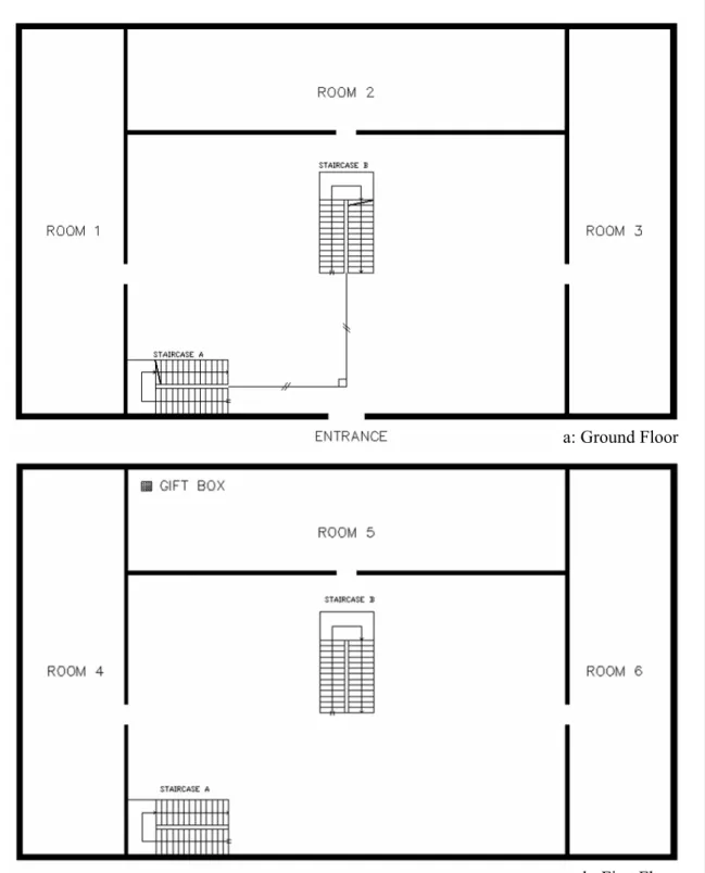
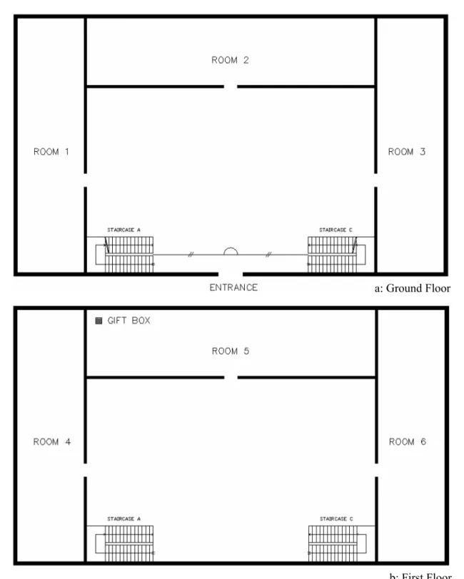
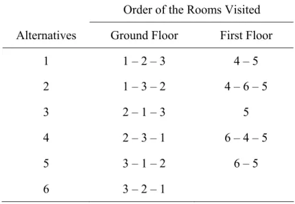
2. Alternative circulation paths of room visits for both sets in the VE ... 66
3. Staircase preferences for both sets in the VE... 67
4. Staircase preferences – ascending and descending within each VE ... 72
5. Group statistics for gender and IPQ ... 74
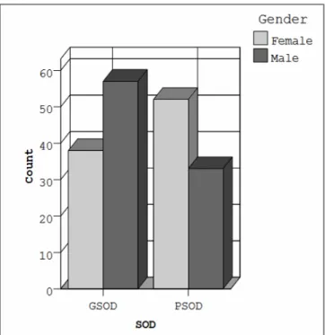
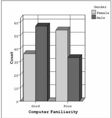
6. Distribution of sense of direction and computer familiarity scores within each set according to gender ... 76
7. Classification of the reasons for utilizing the staircases ... 81
8. First visited room preferences on ground and first floors of Set 1 in the VE... 82
9. Staircase preferences for Set 1 in the VE... 83
10. First visited room preferences on ground and first floors of Set 2 in the VE... 83
11. Staircase preferences for Set 2 in the VE... 84
12. Distribution of virtual navigation total durations according to gender for both sets in the VE... 86
13. Gender differences within each set ... 87
14. Navigational abilities during the virtual navigation... 89
xi
LIST OF FIGURES
1. A general framework for the navigation process for a VE ... 9
2. Navigation model ... 10
3. Taxonomy of virtual travel techniques... 11
4. Taxonomy of virtual travel techniques, with detail shown for the ‘specify position’ subtask... 12
5. Taxonomy of locomotion ... 13
6. Subsystems of the reference frames ... 19
7. Proposed model for vertical navigation ... 53
8. Attributes of D, W, H, A1, A2, L and R of Staircase... 54
9. Set 1: An angle difference of 90° betweenthe cue pair ... 63
10. Set 2: An angle difference of 180° betweenthe cue pair ... 64
11. Gift box ... 65
12. Distribution of sense of direction results according to gender... 73
13. Distribution of computer familiarity results according to gender ... 75
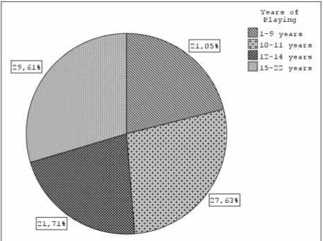
14. Distribution of years of playing computer games ... 77
15. Direct and indirect visual communication ... 100
16. Visibility of the first steps of the staircase ... 100
17. 180° difference between the staircase pairs ... 101
1
CHAPTER 1
INTRODUCTION
Architectural design is the science and art of building that generally encompasses a broad diversity of task such as conceptualization, organization and construction of the built environment. It is a problem-solving activity that influences the
comprehension and knowledge of spatial orientation and navigation in the built environment (Hölscher et al., 2005). While developing the spatial organization of an environment, the designer needs to determine the nature of the wayfinding problems that future users will encounter (Passini, 1996). Hölscher et al. (2005) indicated that developing an architectural space that is adequate and satisfactory is an essentially spatial task. Architectural space is constantly generated in respect to the existing environment and accordingly in a high-dimensional decision space (Hölscher et al., 2005). Decision-making in architectural design consists of processes that utilize external representations in a range of different spatial formats (Freksa et al., 2004).
In the theory of architectural design, the idea of movement is emphasized as a central theme. In order to understand a building’s interior structure and spatial organization, one needs to make her/his way through the building. “To experience architectural
2
space truthfully it is necessary to perambulate and stride the building” (Le Corbusier, 1962: 30, cited in Hölscher et al., 2005). Hölscher et al. (2005) stated that we do not experience the spatial layout of a building as a static structure, but perceive it as a result of movement; we discover architectural cues step by step.
Architectural cues are crucial cues configured by architects in the initial design phase of the design process. Various local architectural cues within an environment can aid individuals during navigation and influence their spatial orientation. With the aid of virtual environments (VEs) local architectural cues can be designed with varying configurations according to the needs of its users. VEs offer their users to navigate in real time and record their navigation behavior.
Staircases, as a feature of local architectural cues can be problematic during vertical circulation since they cause individuals to become disoriented (Soeda et al., 1997). Emphasis is given on staircases since they are one of the main local architectural cues that provide access to the other floors in a multi-level building. Both ‘local architectural cues’ and ‘vertical circulation’ terms are considered separately in various fields by focusing on their qualitative properties; however, in this study, the role of the local architectural cues is examined during vertical navigation in a desktop VE.
3 1.1 Aim of the Study
Architectural design, as a problem solving activity, requires experiencing the spatial organization of a building, discovering local architectural cues and maintaining spatial orientation during navigation. In order to understand the spatial reasoning in architectural design, one needs to consider the factors that affect the spatial updating of the individual in an environment.
The aim of this study is to provide an understanding on how local architectural cues, especially staircases with respect to their geometric attributes, are utilized during vertical navigation and how they influence the individual’s vertical navigation behavior in a multi-level desktop VE. In addition, it aims to examine local
architectural cues from an interior architectural perspective and at the end propose a guideline for interior architects. This study utilizes the VE as a medium for
investigating the role of staircases since the geometric attributes of the staircases can be varied systematically in order to understand their influence on vertical navigation. Vertical navigation is examined by integrating the characteristics of the individuals and the staircase preferences within two different multi-level desktop VEs. This thesis points out the difference between the staircases with respect to their geometric attributes and individual characteristics and tries to understand their utilizations.
4 1.2 Structure of the Thesis
The thesis consists of six chapters. The first chapter is the introduction in which the importance of architectural design with respect to architectural cues is stated and how the staircase, as a local architectural cue, affects vertical navigation in a VE is investigated. The second chapter explores the concepts of navigation, frames of reference, architectural cues and staircases as architectural cues. Firstly, navigation is defined with respect to the travel techniques and navigation strategies. Secondly, during navigation the locations of the spatial representation are presented according to the frames of reference that are identified as the egocentric and environmental subsystems. Next, global and local architectural cues in an environment are defined in relation to architectural cues. Lastly, the importance of staircases as architectural cues is described. In the third chapter, individual differences that consist of gender differences, sense of direction, sense of presence, and previous experience with respect to computer familiarity and computer games are explained.
The fourth chapter states the aim, research questions and hypotheses, describes the proposed model with respect to the participants and virtual environment, and identifies the instruments and software that will be utilized in the study that are ‘Santa Barbara Sense of Direction Scale’ (SDSOB), ‘Computer Aversion, Attitudes and Familiarity Index’ (CAAFI), ‘Igroup Presence Questionnaire’ (IPQ), observation sheet and computer experience questionnaire, and ‘Second Life’.
In the fifth chapter, an experiment is formulated with respect to the proposed model; the participants are identified and the procedure of the experiment is defined.
5
Finally, the results are evaluated and discussed in relation to previous studies related to the subject. In the last chapter, major conclusions about the study are stated, a guideline for interior architects is proposed, various strengths and limitations of the study are stated, and suggestions for further research are generated.
6
CHAPTER 2
VIRTUAL ENVIRONMENTS (VEs)
With the increase in computer usage, VEs have become new areas of navigation. They allow simulated exploration of three-dimensional (3D) environments from a view-centered perspective, allow the creation of environments with different complexity, allow the researchers to have greater control over visual features and complexity of the environment than the real world environments and allow interactive navigation with continuous measurements within it (Belingard and Peruch, 2000; Moffat et al., 2001). Behavior of the individuals within the
environment can be recorded and assessed separately. VEs have become a tool for spatial knowledge acquisition since they offer the opportunity of controlling and manipulating the characteristics of a real world environment. Kirschen et al. (2000) indicated that VEs are used effectively in tests of spatial learning. Spatial knowledge acquired through learning the VEs can be effectively transferred to subsequent navigation in the real world environments (Lessels and Ruddle, 2005; Waller et al., 2001). Waller (2000) demonstrated that spatial knowledge acquired in the VE translates well to the real environment.
7
A VE for architectural use allows interior architects and clients to obtain an immersed view of a building by allowing the user to move through the proposed building (Cutmore et al., 2000). It enables the individual to visualize and interact with the virtual, 3D proposed spatial environment in real time (Çubukcu and Nasar, 2005).
2.1 Navigation
Architectural design is a problem solving activity that requires perceiving the spatial layout, navigating and making inferences about spatial relationships. Navigation is a core functional requirement that individuals perform in VEs (Santos et al., 2009). It is a spatial activity that is guided by visual information of the environment (Zhang, 2008). Bell and Saucier (2004: 252) stated that navigation is “a complex spatial problem that is routinely faced and solved by humans and other animals”. Navigation is a dynamic process where the task and the environment in which it takes place, affects the way a person moves (Särkelä et al., 2009). It can take place in familiar environments or in novel environments in which an individual has little or no prior experience; it can also occur in large environments that are difficult to perceive from a single point. In order to navigate successfully the individuals need to plan their movements using spatial knowledge gained about the environment and stored as mental map (Santos et al., 2009).
Montello and Freundschuh (2005) indicated that navigation is a coordinated and goal directed movement through a space that consists of two parts, travel (locomotion)
8
and wayfinding. Travel is the actual motion from the current location to the new location, changing the position of the viewpoint (Zhang, 2008). It can be referred to as “the perceptual-motor coordination to the local surrounds, and includes activities such as moving towards visible targets and avoiding obstacles” (Montello and Freundschuh, 2005: 69). The second constituent of navigation is wayfinding that refers to the “cognitive coordination to the distant environment, beyond direct sensorimotor access, and includes activities such as trip planning and route choice” (Montello and Freundschuh, 2005: 69) where the path is determined by knowledge of the environment, visual cues and navigational aids. In other words, wayfinding is “the strategic and tactical element that guides movement” (Sadeghian et al., 2006: 2). Therefore, people are aware of their current positions and of how to reach the desired goal. Zhang (2008) stated that wayfinding emphasizes the mental processes of navigation while travel emphasizes the physical processes to execute navigation plans.
Jul and Furnas (1997) designed a general framework for the navigation process for a VE that incorporated the motion component into the mental process (see Figure 1). They identified the important factors in navigation such as forming navigation goals, perceiving spatial knowledge, moving and accessing navigation results (Zhang, 2008). The model starts with a goal-forming step followed by strategy selection. After the selection of the strategy, a tight loop consisting to perception, assessment, cognitive map and motion is processed.
9 Goal forming Strategy selection Perception Motion Assessment Cognitive map
Figure 1. A general framework for the navigation process for a VE (Adapted from Jul and Furnas, 1997).
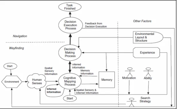
Likewise, building upon Jul and Furnas’ (1997) framework, Chen and Stanney (1999) developed a general model of navigation in which they divided the navigation tasks into three subtasks of cognitive mapping, decision making, and decision
execution (see Figure 2). The model is partitioned into two sections as wayfinding and navigation that reflect the cognitive and motion based components of the process.
10
Figure 2. Navigation model (Martens and Antonenko, 2012: 811; adapted from Chen and Stanney, 1999).
Navigation in the VEs is based on visual movement and the participants navigate with the help of an interface. The most common interface for navigating is mouse and buttons (Burdea and Coiffet, 2003). Although, navigating with a mouse is seen different from actual walking, Zacharias (2006) claimed that the basic movement strategy in well-built VE is similar to the movement strategy in the real environment. “Findings from movement in the VE can, with certain restrictions, be generalized to movement in the real environment” (Särkelä et al., 2009: 788).
2.1.1 Travel Techniques
Since travel and wayfinding are closely related, the method of travel can have an effect on the ability to perform wayfinding tasks and in determining spatial
11
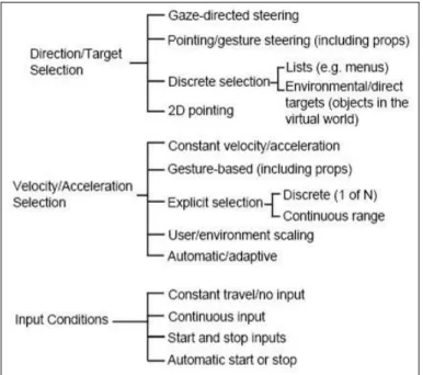
orientation (Bowman et al., 1999). Bowman et al. (1997; 1998) asserted that travel control is as important as spatial knowledge access. They created a taxonomy of travel techniques in a VE that were based on three subtasks: direction or target selection, velocity and acceleration selection, and input conditions (Figure 3). Direction or target selection refers to the method in which the user ‘steers’ the direction of travel or selects the goal position of the movement. Velocity and
acceleration selection methods allow the user/system to set speed and/or acceleration. Finally, input conditions are the ways in which the user or system specifies the beginning time, duration, and end time of the travel motion (Bowman et al., 1997; 1998). The authors concluded that this taxonomy was useful in three ways: it helped them to understand the space of possible techniques, guided them in designing new techniques (choose a component for each of the three subtasks), and helped them to generate ideas for experimental evaluation of techniques.
12
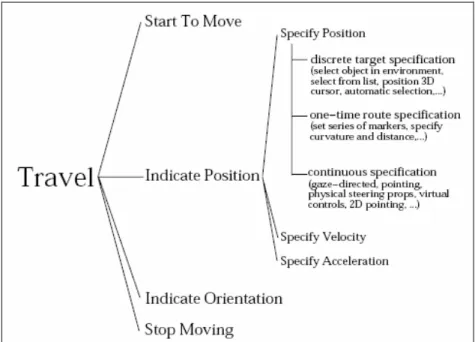
Later, Bowman et al. (1999) developed another taxonomy that considered travel to be the task of setting one’s viewpoint position and orientation in a 3D space (Figure 4). With respect to ‘position’, three different categories with three important factors were identified; these were position, velocity and acceleration. They categorized virtual travel techniques in a VE as discrete target, continuous and one-time
specifications and they distinguished these by the amount of control the users have over their motions. In discrete target specification, the user identifies the target and the system moves the user there, “the user controls the two-end points of motion and leaves the path between those points up to the system” (Bowman et al., 1999: 620). In continuous specification, there is a complete control of the user on the process of moving through an environment. In one-time route specification, there is no control of the user over the motion, in other words, the user defines a path of viewpoint motion and the system moves the user along that path.
Figure 4. Taxonomy of virtual travel techniques, with detail shown for the ‘specify position’ subtask (Bowman et al., 1999: 620).
13
Building upon Bowman et al.’s (1997) framework, Arns (2002, cited in Mabini, 2009) defined travel as the change of location of a viewpoint and divided travel in VEs into two major components as rotation and translation (Figure 5). These components were classified as physical movements, which is the “movement of the user relative to the world” and virtual movements, which is the “movement of the virtual world relative to the user” (Mabini, 2009: 11). In addition, Arns (2002, cited in Mabini, 2009) introduced a classification for interaction and display devices, and portrayed the various ways that they can be combined to create methods of
locomotion.
14
In virtual travel, steering techniques, which allow continuous control of the direction of travel, are mainly used in VEs and they constitute of gaze-directed, pointing-directed and torso-pointing-directed steering (Suma et al., 2010). Gaze-pointing-directed steering is the simplest and most common method in which travel is in the direction the individual is looking, in pointing-directed steering, travel direction is indicated by the
individual’s hand and in torso-directed steering, travel direction is indicated by the individual’s body. Both pointing-directed steering and torso-directed steering decouple the view direction from the travel direction, allowing the individual to look around while moving (Suma et al., 2010). Bowman et al. (1997) indicated that gaze-directed steering was faster than pointing as a travel technique, but the pointing technique to be more accurate.
With respect to Bowman et al.’s (1997) taxonomy, Jeong et al. (2004) stated that although the techniques using position are efficient for navigating in the VE, travel techniques should adopt velocity or acceleration control that allow individuals to change their velocity of travel for more efficient exploration of the environment (Jeong et al., 2009). Jeong et al. (2009: 45) claimed that “by combining pointing and a velocity control technique, users can navigate a VE by indicating the direction that they want to move toward while controlling the velocity at which they would travel”. Various velocity control techniques while using the pointing technique for specifying the target position have been developed. These are count-based (discrete), time-based, gesture-time-based, force-based and speech-based velocity control techniques.
Count-based velocity control technique increases the velocity according to the number of clicks. Time-based velocity control technique measures the duration of a
15
button press, when the button is held down the velocity increases and when the button is released the velocity decreases. Gesture-based velocity control technique allows the individual to control the velocity based on the distance between the individual’s hand and head. Force-based velocity control technique is based on how hard the individual pushes down on a button, which is made with a force-sensing resistor. Finally, speech-based velocity control technique is based on the recognition of different utterances (Jeong et al., 2004; Jeong et al., 2009). Jeong et al. (2009) summarized the results of the five velocity control techniques in Table 1.
Table 1. Summary of the five velocity control techniques (Jeong et al., 2009: 48)
They found that the force-based velocity control technique was more efficient when considering time spent, information gathering ability, amount of collision, sense of presence, ease of learning, ease of use, user comfort and user concentration, whereas, the least effective technique was the count-based velocity control technique (Jeong et al., 2009).
In desktop VEs, the most common travel metaphor used for viewpoint control and navigating architectural buildings is virtual walkthrough (Lapointe and Savard, 2007; Lapointe and Vinson, 2002). Navigation in virtual walkthroughs utilizes various input devices, such as mice, keyboards and joysticks. Lapointe et al. (2011) declared
16
that in virtual walkthroughs, the number of Degrees Of Freedom (DOF) of
movement differs from 2 to 4 out of 6. Three of the six DOFs consist of “translation: forward/back, left/right and up/down”, and the other three DOFs consist of “rotation: rotation around the axis perpendicular to the travel plane (yaw axis), and rotation around each of the axes forming the travel plane (pitch and roll axes)” (Lapointe et al., 2011: 2186). Lapointe et al. (2011) identified four different travel techniques for virtual walkthroughs. The first travel technique involved a keyboard as the input device that controlled 3 DOFs: 2 translation DOFs, which were fore/aft and left/right (strafe) without any rotation, and a rotation along the horizontal plane around the vertical axis (yaw). The second travel technique was based on a mouse that
consisted of two DOFs: one translation (fore/aft) and one rotation (yaw). The third travel technique was a joystick with 3 DOFs: strafe, fore/aft and yaw. The final travel technique consisted of a gamepad with two mini joysticks that controlled 2 translation DOFs: strafe and fore/aft, and one rotation: yaw. In each travel technique, the velocities of the translation and rotation movements were kept constant.
Lapointe et al. (2011) concluded that the mouse travel technique provided better performance than the other travel techniques and subjective ratings indicated that the mouse travel technique provided ease of use, speed, accuracy and overall preference. They indicated that a two-handed travel technique consisting of a keyboard and a mouse would be interesting to test since this travel technique is extensively utilized in first-person 3D computer games.
17 2.1.2 Navigation Strategies
When people have an imprecise or incomplete spatial knowledge, they need to rely on navigation strategies. Various strategies have been identified for two-dimensional and three-dimensional settings. Hochmair and Frank (2002) and Conroy-Dalton (2003) described ‘the least-angle strategy’ as the process of selecting the path that had the least deviation from the target direction when the target direction was known, but the environment was unknown at intersections. Wiener and Mallot (2003)
investigated the role of environmental regions with a hierarchical planning approach. They developed a cognitive model of region-based route planning referred to as ‘the fine-to-coarse planning strategy’ in which the environment was cognitively
segmented into regions that guided navigation decisions. In the currently occupied region, routes are planned in detail, but coarsely when planning navigation between regions (Spiers and Maguire, 2008). In addition, Wiener et al. (2004) identified two other strategies: ‘the cluster strategy’ and ‘the least-decision-load strategy’. The cluster strategy states that route planning considers the distribution of target locations within an environment, resulting in a preference for paths that allow visiting as many targets as fast as possible. The least-decision-load strategy states that the subjects, when they have the choice of choosing between alternative paths, choose the path that minimizes the number of possible movement decisions (Wiener et al., 2004; Tenbrink and Wiener, 2007).
On the other hand, Hölscher et al. (2006) identified three strategies for finding one’s way in 3D settings; these were ‘central point strategy’, ‘direction strategy’ and ‘floor strategy’. In the central point strategy, the individual stays as close as possible to
18
well-known parts of the building, such as the main entry hall and main connecting corridors. The direction strategy aims at choosing routes that head towards the horizontal position of the goal as directly as possible, regardless of level changes. In the floor strategy, the individual first moves to the correct floor in the building, regardless of the horizontal position of the goal, then starts a fine-tuned search (Hölscher et al., 2005; 2006).
2.2 Frames of Reference
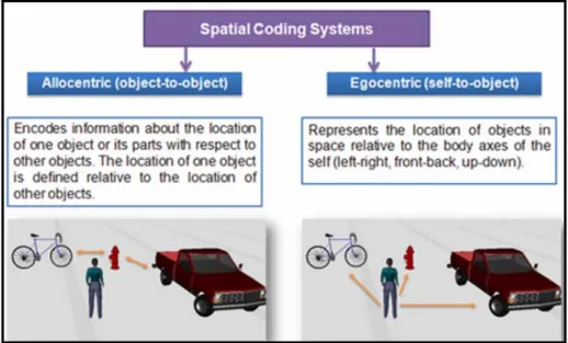
Mou et al. (2004) proposed that the human navigation and spatial representation system consists of subsystems namely as the egocentric and the environmental (allocentric) frames of reference (see Figure 6). The egocentric frame of reference represents object locations in the transient self-to-object relations; it guides
interaction with the immediate surroundings. Iachini et al. (2009) stated that egocentric frame of reference is determined by the position of the viewer in the environment and egocentric spatial representations sustain the viewing perspective. Stored spatial information is accessed with respect to the body position of the viewer (Iachini et al., 2009). Alternately, the environmental frame of reference is
responsible for representing the spatial environments; it is independent of the viewer’s position and is focused on external objects and features of the environment (Iachini et al., 2009). “Interobject spatial relations are represented independent of the observer using allocentric reference frames” (Rump and McNamara, 2007: 253).
19
Figure 6. Subsystems of the reference frames (Imagery Lab, n.d.)
When travelling through an environment, updating occurs in both frames of
reference. In the egocentric frame of reference, the transient self-to-object relations are updated as long as vision support is available. This updating is efficient and needs minimal attentional control, but egocentric updating becomes more effortful and restricted to a small number of objects when vision support diminishes. Egocentric updating allows an individual to avoid obstacles, keep track of
surrounding objects, but it does not prevent her/him from getting lost. In order to stay oriented, the individual needs to know her/his position with respect to familiar objects in the environment and the spatial layout of the objects need to be
represented over the long term. These representations are presented in the
environmental frame of reference. Updating in the environmental frame of reference consists of “keeping track of location and orientation with respect to the intrinsic reference system used to represent the spatial structure of the environment. Self-to-object and Self-to-object-to-Self-to-object spatial relations are specified in the same intrinsic reference system. The body is treated like any other object in the environment” (Mou et al., 2004: 154). When navigating in the VE an egocentric viewpoint that is
20
perceived from the perspective of the user will provide a greater sense of self and awareness of objects in the VE than an exocentric viewpoint, which provides a third person perspective (Ma and Kaber, 2006). Iachini et al. (2009) claimed that when the environment was familiar and was characterized by regular and prominent environmental axes, environmental frame of reference was used, but when it was unfamiliar egocentric frame of reference was utilized.
2.3 Architectural Cues
When people navigate in unfamiliar VEs, the design of the VE should promote rapid information that is necessary for successful navigation and orientation. The
navigators need to develop accurate spatial information as quickly as possible when information is represented by the relative size, orientation and position of virtual objects (Vinson, 1999). Navigation and orientation in the VE can be enhanced by the cues that people use while navigating in the real environments. These cues are comprised of all kinds of information that is available in the environment, such as ‘verbal’, ‘graphic’, ‘architectural’ and ‘spatial’ cues (Sun and de Vries, 2009). Sun and de Vries (2009) asserted that an architectural cue is a crucial one that is
configured by the architects in the initial phase during design process. In the initial phase, the architectural space that is composed of architectural elements can offer a variety of meanings (Lawson, 2001; Rapoport, 1982) that can be perceived by users and have an impact on their behavior patterns (Sun and de Vries, 2009). An
architectural cue shapes the behavior pattern of the user of the built environment (Sun, 2009). For example, an entrance that is bigger in scale may look more like an
21
entrance and attract more users that a smaller one on the same façade (Lawson, 2001).
Architectural cues do not only indicate a reference to position and orientation, but they also contribute to the development of spatial knowledge. Various guidelines have been proposed by Vinson (1999) in order to support navigation and orientation in a VE such as:
• It is essential that a VE contains several cues; the navigator can determine her/his position in the environment through her/his knowledge of the position of the cues.
• Cues should be made distinctive with their heights, complex shapes, unique exterior colors and textures and be free standing.
• Cues should be chosen from concrete things rather than abstract ones to make them more recognizable.
• Cues must be visible and distinguishable from nearby objects and other cues in order to easily prevent confusion or wrong navigational action in a VE.
• The sides of the cue should be differentiated from each other to help navigators decide their orientation.
• The placement of the cues should be well defined and they should be placed on major paths and at path junctions. By this way, the cue can be more memorable.
Architectural cues are essential in the environment and are not easy to rebuild. They are categorized as global architectural cues and local architectural cues (Sun, 2009).
22 2.3.1 Global Architectural Cues
Sun (2009) stated that global architectural cues are perceived from the architectural forms and provide information about how the parts of the building are organized globally. They are considered as the only source to form the cognitive map that is perceived through travelling in the environment (Sun, 2009). They can serve as references to absolute location and provide a stable frame of reference (Lin et al., 2012). There are four types of sources in the built environment that provide the global architectural cues. They are the circulation system, the exterior form of the building, the visible structural frameworks and the atrium (Sun, 2009).
According to Arthur and Passini (1992), the circulation system is the main organizing feature and a determining factor for the layout of an environment. Circulation systems are classified into four categories as linear circulations, centralized circulations, composite circulations and circulation networks (scatter-point networks, grid networks and hierarchical networks). In addition, the
circulation system determines the space in which people travel, try to understand, find their way and make wayfinding decisions. Arthur and Passini (1992) stated that circulation should not be considered just as a link between spaces, but as a space. When people navigate in the circulation system of a building, they are able to understand the spatial organization and the typology of the system (Arthur and Passini, 1992; Sun, 2009).
The exterior form of a building provides clues about the spatial organization and circulation system and gives “a setting an objectlike quality, which is easy to grasp and to retain” (Arthur and Passini, 1992: 89). Likewise, the visible structural
23
framework inside a building gives clues about the spatial organization. Spatial information such as the symmetry axis, elongation (linear organization) and
functional characteristics can be presented by the structural framework (Werner and Schindler, 2004). Furthermore, the atrium provides the individuals with a visual and sometimes auditory access to the spatial organization of the building (Arthur and Passini, 1992). Individuals are able to sense a part of the building’s volume and view the different floors of the building (Sun, 2009). Sun (2009: 28-29) claimed that “a single perspective of the space contains more information than the one in a closed floor arrangement”. Lawton et al. (1970, cited in Tang et al., 2009) indicated that simple corridor systems and central atrium systems that allowed perceptual access between spaces enhanced orientation . Likewise, Arthur and Passini (1992)
suggested that buildings that are organized around an open core enable the users to perceive the form of the circulation system.
2.3.2 Local Architectural Cues
The local architectural cue is based on the features of the architectural elements that are locally perceivable (Sun and de Vries, 2009). In other words, it is a type of information that is perceived from the architectural forms and is based on the abstract 3D geometric features of the local architectural elements, such as doorway entrances, stairs, exits and corridors (Sun, 2009). They can be observed at limited locations and from restricted perspectives (Lin et al., 2012). Local and global architectural cues can aid the formulation of and access to cognitive maps (Lin et al., 2012). Sun (2009) deduced a list of local architectural cues that were considered to be influential
24
during an evacuation from an underground space. These were vertical outdoor light, stair, doorway entrance, raised ceiling, columns, lighted ceiling, escalator, handrail and lift from the most attractive to the least (Sun and de Vries, 2009). In addition, Sun (2009) identified four types of sources that determine the local architectural cues. These consist of type of the architectural element in the circulation system, distance from the architectural element to the individual, scale of the architectural element and angular position of the architectural element with respect to the
individual’s view (Sun, 2009). The scale of the cue involves the width and the height of the cue.
Likewise, two attributes can be proposed to describe the features of the local architectural cues; geometric attributes and featural attributes. Geometric attributes are structural or surface features in the environment (Lin et al., 2012) and they are “provided by extended environmental surfaces, like the shapes formed by room walls or intersecting streets” (Kelly et al., 2008: 281). Featural attributes consist of non-geometric properties, such as color, texture, figure-ground relationship and
complexity that cannot be described in geometric terms (Kelly et al., 2008), but can be easily distinguished from the background (Lin et al., 2012).
2.4 Staircases as Architectural Cues
The local architectural cue like the global architecture cue has a close relationship with the circulation system of the building (Sun, 2009). Arthur and Passini (1992) specified four types of local architectural cues that define a circulation system.
25
These were the entrance, which gave access to the building, the exit, which indicated where to leave the building, the path, which indicated the direction of movement and where to enter the other spaces, and the vertical access, which indicated where to go in order to change levels within the building (Arthur and Passini, 1992; Sun, 2009).
One of most important local architecture cue that enables vertical circulation in a multi-level building is the staircase. In architecture, the staircase functions as an important circulation node, a vertical interconnection and enables movement
between the different levels of the building (Hölscher et al., 2006). Staircases help to combine vertical information during movement and enable the individual to
understand the spatial organization of the building (Hölscher et al., 2006). Since vertical circulation is one of the most important aspects of good building design, architects need to consider two key design parameters while designing the staircases. The first one is “the constructional and representational form of its appearance have to be highlighted with respect to the function of the building” and secondly, the position of the staircase has to be designed accordingly with the individual’s activity within the building (Hölscher et al., 2006: 297).
Nicoll (2007) stated that staircase use is an underlying activity of purposeful travel and is affected by the way people understand and travel through buildings. Olander (2009) claimed that environmental variables such as staircase location and visibility, staircase and building height and escalator/lift availability have an impact on
staircase use. Staircases are likely to be utilized more when they are conveniently located closer to the entrance and are visible. Staircase geometry that comprises of the riser, tread and pitch can influence staircase use. High buildings and high steps
26
result in less staircase use; individuals are likely to climb 9 to 18 step staircases and between 2 to 4 floors. Bungum et al. (2007) suggested that the number of floors in a building is a predictor of stair use; as the number of floors increases, stair use
decreases. Staircase use decreases when lifts are more visible and faster; staircases are used for shorter distances, whereas lifts are preferred for longer distances.
Nicoll (2007) concluded that staircase use was influenced by the placement of the staircase rather than the appearance of the staircase. According to Nicoll (2007), the most prominent spatial measures that increased stair usage were stair width and stair type. Stair width is one of the strongest predictors of stair usage because people travelling in groups are more likely to remain engaged in conversation when taking the staircases. In addition, Nicoll (2006) recommended that:
• Staircases should be located directly along the main paths of circulation, at or linking the main entrance to the building.
• Staircases should be located between the entrance and the elevator in order to increase their visibility from the entrance so that they are closer and are more visible than the elevator.
• Staircases should be located so that their first step is visible from the elevator.
• Staircases should be located according to where people are situated in the building so that they are in close proximity and are highly visible. They should be between spaces where people work, come together, travel and the elevator.
• Staircases should be oriented accordingly so that they are visible from the largest area where people travel and they are more visible than the
27
elevator from the entrance and from multiple directions of travel within the building’s main circulation paths.
• Entrance doors to the staircases and the first step of the staircases should be oriented in such a way that they have the fewest turns in direction to enter the staircase from the entrance and the main circulation paths in the building.
• Sufficient stair width should be provided to accommodate people travelling in groups for different purposes, such as social engagement, high occupancy movement and emergency exiting.
• The accessibility between the floors at all levels should be maintained. Staircases should be located within the public area of the building. • The visibility of the staircases should be increased by providing open staircases.
Within the scope of the study, sources that provide local architectural cues, which are defined by Sun (2009), will be utilized. These are the type of the cue in the
circulation system, which is the staircase, the distance from the staircase to the individual, the scale and the angular positions of the staircase in the individual’s view.
In a multi-level building, vertical travel is a spatial problem solving activity in which the individuals need to update their spatial orientation within the building without getting disoriented. The next chapter explains the individual differences that can affect an individual’s ability to acquire spatial information.
28
CHAPTER 3
INDIVIDUAL DIFFERENCES IN VEs
Individual differences are one of the important factors that influence navigation. Various aspects of individual differences have been identified, such as age,
educational background, learning style and spatial familiarity, but with respect to the case study gender differences, sense of direction, sense of presence and previous experience of the individuals are recognized as the factors that affect an individual’s ability to acquire spatial information.
3.1 Gender Differences
Previous studies showed that there are gender differences in the ability to acquire spatial information and navigate through real environments and VEs. This may be the result of the different type of information that males and females focus within their environments (Sandstrom et al., 1998; Saucier et al., 2003; Tlauka et al., 2005). Studies have shown that males and females employ different types of strategies and focus on different properties of the environment (Sandstrom et al., 1998).
29
Sandstrom et al. (1998) reported that males and females use different navigational strategies during the self-report measures. Males employed an Euclidean approach in navigating to a target, using cardinal directions and absolute distance (allocentric strategy), whereas females used a topographic strategy that relied more on visual landmarks and egocentric directions (i.e. left/right) (egocentric strategy) (Barkley and Gabriel, 2007; Chai and Jacobs, 2009; Chen et al., 2009; Coluccia and Louse, 2004; Dabbs et al., 1998; Picucci et al., 2011; Sandstrom et al., 1998; Saucier et al., 2003; Tlauka et al., 2005). Males formed a more accurate representation of the Euclidean or geometric properties, whereas females formed a more accurate representation of the landmarks in the 2D environment (Sandstrom et al., 1998). Females are superior at using landmark-based strategies when navigating and they have better memories for identity and location of landmarks, whereas males have enhanced knowledge of the Euclidean properties of the environment that are distance and directional cues (Dabbs et al., 1998; Iachini et al., 2005; Sandstrom et al., 1998; Saucier et al., 2003).
Devlin and Bernstein (1995) tested how males and females utilized different types of wayfinding information. They concluded that males preferred to use visual-spatial cues more than females in a computer simulated campus tour. Likewise, Sandstrom et al. (1998) indicated that females rely mainly on landmark information, while males use both landmark and geometric information in which landmarks and room geometry were the distal cues in a VE navigation task. In addition, when landmark and geometric information were available, males were faster than females at reaching a hidden target.
30
When people give navigational directions to others, females refer more to cues and other visual objects along a route. They also show greater accuracy in recalling cues and in estimating distances to cues, and report using a route-based navigation
strategy. They provide more landmark information than do men. On the other hand, it is reported that males use more cardinal directions, often provide more cardinal descriptions and use an orientation strategy (Cherney et al., 2008; Dabbs et al., 1998; Hund et al., 2008; Hund and Minarik, 2006; Iachini et al., 2005; Lawton and Morrin, 1999; O’Laughlin and Brubaker, 1998; Sandstrom et al., 1998; Saucier et al., 2003).
Dabbs et al. (1998) suggested that the memory of object location assisted the use of landmarks in navigation, whereas 3D visualization developed the use of abstract Euclidean navigation. Lavenex and Lavenex (2010) indicated that although females and males exhibit different strategies when solving a real world spatial relational memory task in which females considered the local cues and males considered the local and spatial cues, they did not differ in their overall ability and accuracy to solve the task. In addition, males and females differ in the amount of attention that is given to the objects in the environment. Females have better object memory than males in remembering the location and identity of previously viewed objects
(Barkley and Gabriel, 2007; James and Kimura, 1997; Levy et al., 2005; Voyer et al., 2007). Barkley and Gabriel (2007) claimed that the female superiority in object memory may be the result of females using positional, landmark-based strategies for navigation. James and Kimura (1997) found that when location and identity of an object were to be integrated females outperformed males; females showed better location memory performance. Similarly, Levy et al. (2005) found a female
31
no gender difference in object identity recognition (De Goede and Postma, 2008; Iachini et al., 2005).
There has been a significant advantage of males for spatial route learning through an unfamiliar environment and on tasks requiring survey knowledge, for example pointing directions, drawing a sketch map and estimating travel distances (Castelli et al., 2008; Coluccia et al., 2007; Çubukcu and Nasar, 2005; Devlin and Bernstein, 1995; Lawton and Morrin, 1999; Moffat et al., 1998; O’Laughlin and Brubaker, 1998; Tlauka et al., 2005) and males having better navigational performance than females (Chen et al., 2009). Females reported a higher level of anxiety than do men about performing spatial tasks, were less confident than men when drawing maps of a floor plan and having a greater feeling of uncertainty when navigating in a building (Lawton and Kallai, 2002; Lawton et al., 1996; O’Laughlin and Brubaker, 1998). However, Iachini et al. (2005) found no gender difference in object recognition and in remembering absolute distance and categorical spatial relations, but males were better than females in remembering the distance between the objects and the size of the layout. In addition, Sancaktar and Demirkan (2008) found no gender differences in a spatial updating task in a VE. Both males and females could orient themselves within the VE and accurately identify the relative positions of various areas in the VE.
Tlauka et al. (2005) expressed that gender was a predictor of spatial performance in the real world and in the VEs. With respect to the acquisition of spatial knowledge through virtual navigation, an inconsistent pattern of gender differences were revealed. Some studies reported a male advantage in a virtual maze navigation task
32
(Lawton and Morrin, 1999; Moffat et al., 1998; Sandstrom et al., 1998; Waller, 2000); however, no gender difference was indicated in spatial knowledge tests in VEs (Darken and Sibert, 1996; Sancaktar and Demirkan, 2008; Wilson et al., 1997).
3.2 Sense of Direction
Besides gender differences, sense of direction or “awareness of orientation or location” is an important individual difference (Kozlowski and Bryant, 1977: 178, cited in Padgitt and Hund, 2012). According to Sholl et al. (2000: 17), sense of direction is “the knowledge of the location and orientation of the body with respect to the large stationary objects, or landmarks, attached to the surface of the earth”. The sense of direction is related to the ability to update one’s orientation and location in space with body movement in the environment (Hegarty et al., 2002), also it is related to people’s ability to maintain their orientation to distal landmarks (Sholl et al., 2000). Kozlowski and Bryant (1977, cited in Padgitt and Hund, 2012)
considered sense of direction as a cognitive ability that could aid individuals during navigation. Passini (1984) emphasized that sense of direction may be related to self-evaluation of environmental knowledge, whereas Sholl (1988, cited in Heth et al., 2002: 310) emphasized that sense of direction may be related “to the ability to mentally coordinate egocentric and imagined frames of reference. She suggested that this skill is important for learning new environments and orienting within obscure environments”.
33
According to Allen (1999), the sense of direction is the key to the success of orientation behavior; people with a poor sense of direction usually cannot find the destination easily during travelling. They are more likely to lose their way, worry about becoming lost, and feel more anxious when they are lost (Sholl et al., 2000). People with a good sense of direction explore and focus on details in new
environments, give and follow directions and they remember new routes better than do people with poor sense of direction (Sholl et al., 2000). Likewise, Heth et al. (2002) stated that people with a good sense of direction can seek for landmarks and utilize them during their navigation, and orient the mental representation of the landmark configuration to correspond with the perceived environment (Cornell et al., 2003).
Sense of direction can be measured by using behavioral tasks, for example pointing to non-visible locations is the most common method (Heth et al., 2002). According to Sholl et al. (2000: 17), a behavioral measure of sense of direction is “the accuracy of people’s pointing responses to familiar, but non-visible, landmarks in the
surrounding environment”. Kozlowski and Bryant (1977, cited in Heth et al., 2002) found no difference between participants who rated themselves with either a good or poor sense of direction when pointing to locations in an unfamiliar tunnel complex. Participants who rated themselves with a good sense of direction showed
improvements in pointing accuracy over four walks through the complex. Sholl (1988, cited in Cornell et al., 2003) indicated that participants with a good sense of direction were more accurate at pointing to landmarks when they had to imagine a viewpoint that was not aligned with their forward facing. In another study, Kato and Takeuchi (2003) guided female participants through a route and then asked them to
34
find their way by themselves. Participants with a good sense of direction showed better performance on route learning than participants with a poor sense of direction. Likewise, when Cornell et al. (2003) asked their participants to rate their sense of direction, correlations between self-ratings and accuracy of pointing to imagined landmarks, accuracy of path choices during a route reversal and detour, and speed at performing shortcuts were found. Hund and Nazarczuk (2009) found that
participants with larger pointing errors exhibited more wayfinding errors and took longer when navigating in a campus building than participants with smaller sense of direction errors.
Hegarty and her colleagues (2002) developed a standardized self-report scale, a 15 item Santa Barbara Sense of Direction Scale (SBSOD) to assess the effect of sense of direction on various spatial tasks (see Appendix A). When people rate their sense of direction as good or poor, they are basing their judgments on environment tasks such as wayfinding, remaining oriented in an environment, learning layouts, using maps to navigate and giving and following directions. The SBSOD reflects the ability to orient oneself in an environment (Hegarty et al., 2002). Once the scores on the items containing negative statements have been inverted, the total score is calculated by totaling the individual scores. Higher scores on the scale are correlated with more accuracy when pointing to unseen landmarks and to the starting point of a path followed during wayfinding.
Previous studies asserted that people’s self-ratings of sense of direction are reliable predictors of spatial orientation and wayfinding, and sense of direction is positively correlated with orientation strategies and negatively correlated with route strategies
35
(Hegarty et al., 2006; Hund and Nazarczuk, 2009; Kato and Takeuchi, 2003; Prestopnik and Roskos-Ewoldsen, 2000; Sholl et al., 2000). Padgitt and Hund (2012) demonstrated that self-reports of sense of direction and wayfinding were related. They found that people with a good self-reported sense of direction indicated higher ratings to survey descriptions consisting of cardinal directions, distances, left-rights and choice point landmarks, and made fewer wayfinding errors than did people with a poor self-reported sense of direction (Hund and Padgitt, 2010; Padgitt and Hund, 2012). In addition, they indicated that people with a poor sense of direction may be disadvantaged in finding their way through a new environment or deviating from a given path, they can overcome these problems with training and practice (Hartley et al., 2003; Hund and Nazarczuk, 2009).
There are controversial results related to gender differences with respect to sense of direction. Cornell et al. (2003) did not find a consistent gender difference in the wayfinding task; however, female participants rated their sense of direction as worse than males. Females were less accurate and slower than males in estimating bearings form imagined vantage points and performing shortcuts. Hund and Nazarczuk (2009) did not find a gender difference in the behavioral sense of direction pointing task; however, female participants reported a lower sense of direction in the self-report measure. Castelli et al. (2008) found no gender differences in the self-self-report measure.
36 3.3 Sense of Presence
VEs enable people to experience, navigate and interact with virtual cues intuitively in real time. During this interaction, they often experience a sense of being in the VE that is referred to as presence. In order to be fully spatially present in the VE, the individual has to forget about the physical environment and accept the VE as the only reference frame (Riecke, 2003). In addition, the VE should be immersive and easy to use so that the participant does not pay attention to the equipment and experiences a sense of being there in the VE.
Presence is a multi-dimensional construct with various definitions and concepts such as spatial presence, social presence and co-presence (Lee and Kim, 2008).
According to Lombard and Ditton (1997), presence is a perceptual illusion of non-mediation in which the technology becomes invisible and unnoticed by the user. Slater and Wilbur (1997: 604) defined it as a “state of consciousness, the
(psychological) sense of being in the virtual environment”. Sadowski and Stanney (2002: 791) described presence as “a sense of belief that one has left the real world and is now ‘present’ in the virtual environment”. Presence implies that observers perceive their self-orientation and self-location with respect to the environment (Riecke, 2003; Wissmath et al., 2011). Presence is experienced “when the users accept the medium as primary egocentric reference frame and when they reject the immediate environment as primary egocentric reference frame” (Wissmath et al., 2011: 1809).
37
Similarly, Witmer and Singer (1998: 225) defined presence as “the subjective experience of being in one place or environment, even when one is physically situated in another” and “experiencing the computer-generated environment rather than the actual physical locale”. They argued that experiencing presence in a VE relied on the ability to focus on coherent stimuli in the VE to the exclusion of the unrelated stimuli in real life. As participants focus their attention, they become psychologically involved and attached to the VE stimuli or activities. In addition, participants can be immersed that is the “psychological state characterized by perceiving oneself to be enveloped by, included in, and interacting with an
environment that provides a continuous stream of stimuli and experiences” (Witmer and Singer, 1998: 227). They stated that involvement and immersion are necessary for experiencing presence, and higher degree of involvement and immersion in a VE would result in a higher sense of presence.
Likewise, Schubert et al. (1999) used the term spatial presence in order to indicate “the sense of being in a physical space or virtual environment (VE) and having a mental representation of one’s own body as a part of a space or VE” (Lee and Kim, 2008: 491). They proposed an embodied presence model, which was built upon the embodied cognition approach of Glenberg (1997) and described the cognitive processes that lead to presence (Regenbrecht and Schubert, 2002; Schubert et al., 1999; 2001). They indicated that presence developed from the cognitive
representation of possible actions that could be performed in the VE, in other words, the VE is conceptualized in terms of possible actions. A mental representation of the environment is made in terms of patterns of possible actions, based on perception and memory. These actions, which are represented mentally, are bodily actions
38
within the VE and functionally related to navigation, manipulation of objects or interactions with other agents (Regenbrecht and Schubert, 2002; Schubert et al., 2001). “A sense of presence develops from the mental representation of movement of the own body (or body parts) as a possible action in the VE, or from meshing (Glenberg, 1997) of bodily actions with objects or agents in the VE” (Regenbrecht and Schubert, 2002: 426). They argued that sense of presence consists of two components: construction of a mental model, which is “the sense that we are located in and act from within the VE” and attention allocation, which is “the sense that we are concentrating on the VE and ignoring the real environment” (Schubert et al., 2001: 269). “Users who place themselves in the virtual space by navigating and interacting with the objects are more likely to experience presence as they mentally remove themselves from the real to the virtual world” (Alsina-Jurnet and Gutiérrez-Maldonado, 2010: 791).
There are two methods of measuring the degree of presence that a user experiences in a VE: objective and subjective measures (Thornson et al., 2009). Objective or behavioral measures are performed by observing the automatic responses of the participants during the virtual experience. These automatic responses consist of the participant’s heart rate, skin temperature, skin conductance, blood pressure, muscle tension, respiration rate, ocular response and posture. Subjective measures rely on the self-assessment of the participant and they are accumulated by pretest and/or post-test (Thornson et al., 2009).
The most commonly used measures in the presence research are the use of subjective ratings through questionnaires since presence is a subjective experience (Sadowski