Γ ·'." '* ''·^ :^ ί·,·ζ Ν
ч-^ \ ' j ä ? τ · V ” Y 7 * ^ ·, ■·_ Q í * .
r-THE NEOLITHIC OF CENTRAL A N D
NORTHWESTERN ANATOLIA,
THRACE AND ITS RELATIONS
WITH SOUTHEASTERN EUROPE
The Institute o f Economics and Social Sciences
o f
Bilkent University
by
BULENT ARIKAN
In Partial Fulfillment o f the Requirements for the Degree o f
MASTER OF ARTS
m
THE DEPARTMENT OF
ARCHAEOLOGY AND HISTORY OF ART
BILKENT UNIVERSITY
ANKARA
June 2000
,гз
A-W ДОООI certify that I have read this thesis and have found that it is iiilly adequate, in scope and in quality, as a thesis for the degree o f Master o f Arts.
Dr. Barbara B. Helwing
Supervisor d
I certify that I have read this thesis and have found that it is fully adequate, in scope and in quality, as a thesis for the degree o f Master o f Arts.
Doç. Dr. İlknur Özgen
Examining Committee Member
I certify that I have read this thesis and have found that it is fully adequate, in scope and in quality, as a thesis for the degree o f Master o f Arts.
Dr. Jean Ozturk
Examining Committee Member
I certify that I have read this thesis and have found that it is fiilly adequate, in scope and in quality, as a thesis for the degree o f Master o f Arts.
Dr. Norbert Karg
Examining Committee Member
Approved by the Institute o f Ecqniunics and Social Sciences
Prof Dr. Ali Karaosmanoglu Director
ABSTRACT
THE NEOLITHIC OF CENTRAL AND NORTHWESTERN ANATOLIA, THRACE AND ITS RELATIONS WITH
SOUTH EASTERN EUROPE Arikan, Bülent
Master, Department of Archaeology and History of Art Supervisor: Dr. Barbara B. Helwing
June 2000
In this thesis, I intend to focus on the Neolithic of North-West Anatolia. Thanks to recent research activities by M.Özdoğan (1997; 1998c& d; 1999b), T. Efe (1995, 2000) and J. J. Roodenberg (1995a& b; 2000a& b) it is now possible to define a North-West Anatolian Neolithic. With such a definition, it will be possible to decide whether this néolithisation can be understood as an autonomous development or as a consequence o f diffusion from another place most probably from the Near East. It is also aimed to present a clearer chronology, which is most needed at this stage o f researches.
As a base for the discussion, a thorough synthesis of the development in architecture and pottery will be presented.^ Other groups of material culture will be used in a selective way, in order to emphasise relationships, since a full discussion is beyond the limits o f M.A. thesis. The area covered comprises Central Anatolia (Can Hasan III, Suberde Musular, Erbaba, Köşk Höyük), the Lake District (Hacılar, Bademağacı, Höyücek and Kuruçay), Marmara (Ihpınar, Fikirtepe and Pendik) and Turkish Thrace (Hoca Çeşme, Aşağı Pınar and Yarımburgaz). It will allow a general description of the cultural and chronological development of the North-West Anatolian Neolithic, its long
' Detailed discussions on the rest of the cultural material is not included since it will be simply too much for a Master’s tliesis. A recent publication, wliich is known as TAY (Hamiankaya, Tanmdi and Ozba§aran, 1997) fullfils tlie function of a site inventory. Therefore tliere is no need to create another
distance contacts and its cultural connections. A comparison between the North-West Anatolian Neolithic and the Neolithic cultures o f neighbouring regions, especially the Balkans and Central Anatolia will help to understand mutual relationships between these areas. In the conclusion, the néolithisation process in the Marmara and Turkish Thrace and its relations with the neighbouring regions will be evaluated.
ÖZET
ANADOLU’DA ORTA, KUZEYBATI VE TÜRK TRAKYASI BÖLGELERİNDE NEOLİTİK DÖNEMİ VE
GÜNEYDOĞU AVRUPA İLE İLİŞKİLERİ Arıkan, Bülent
Yüksek Lisans, Arkeoloji ve Sanat Tarihi Bölümü Tez Yöneticisi: Dr. Barbara B. Helwing
Haziran 2000
Prehistorik alanda yapılan ilk çalışmalardan itibaren, “Neolitik”
(Cilalı Taş Devri) kavramının tanımlanması tartışma konusu olmuştur. Günümüzde, halen bu tartışmalar ve çatışmalar güncelliğini korumaktadır.
Bu tez çalışmasında. Kuzeybatı Anadolu Bölgesindeki Neolitik yerleşimler incelenmiştir. Son dönemlerde, M. Özdoğan (1997; 1998 c& d; 1999b), T. Efe (1990; 1994; 1995; 2000) ve. J.J. Roodenberg (1995b& c& d; 2000a& b) tarafından yapılan araştırma ve yayınlar yardımıyla. Kuzeybatı
Anadolu Neolitik Dönemini tanımlamak mümkün olmuştur. Böylesi bir
tanımlama ile “Neolitikleşme” sürecinin kendiliğinden gelişen bir olay mı,
yoksa; bir yerden, büyük bir olasılıkla Ön Asya’dan, bir başka yere
göçedenlerce ortaya çıkarılan bir olgu mu olabileceği anlaşılabilir. Ayrıca, bu
çalışma da, benzerlerinde eksikliği hissedilen net ve açık bir zamandizini
sunmak hedeflenmiştir.
Bu teze, mimari ve çanak çömlek bulgularını içeren eksiksiz bir bireşim dahil edilmiştir'. Bu çerçeve dahilinde, Orta Anadolu’da (Can Haşan
1 Mimarı ve seramik dışmda kalan diğer buluntular hakkmda detaylı incelemenin yiisek lisans tezi smırlaı ınm dışuıa taşacağı düşimülmek'tedir. Yakuı zamanda çıkan, TAY adı verilen ve yerleşimlerin, bulınıtularıyla beraber envanteılenmesi esasuıa dayanan yaym, bu amaca hizmet etmekledir. Bu nedenle yeni bir envanter yapmak gereksizdir.
III, Suberde, Musular, Erbaba, Köşk Höyük) Göller Bölgesinde (Hacılar, Bademağacı, Höyücek ve Kuruçay), Marmara’da (Ilıpmar, Fikirtepe ve Pendik) ve Türk Trakya’sında Hoca Çeşme, Aşağıpınar ve Yarımburgaz yerleşimleri değerlendirilmiştir. İki ana yerleşim olma özelliği taşıyan ve detaylı bir biçimde arkeolojik verileri değerlendirilmiş ve kaydedilmiş olan Aşıklı Höyük (Esin,
1991; 1991 et al; 1992b) ve Çatal Höyük -doğu- yerleşimleri teze dahil
edilmezken, Kuzeybatı Anadolu Neolitik dönemi kültürel ve kronolojik bulgularıyla değerlendirilecektir. Değerlendirme bu bölgenin, diğer coğrafık alanlarla olan kültürel bağlantıları ve temaslarının incelenmesini içerecektir. Kuzeybatı Anadolu Neolitik dönemi ve Balkanlar ve Orta Anadolu Neolitik
dönem karakteristik özellikleri bakımından kıyasianacaktır. Böylece farklı
TABLE OF CONTENTS
VOLUME I Page
ABSTRACT ... ii
OZ ...iv
TABLE OF CONTENTS ...vi
LIST OF FIGURES ... xii
CHAPTER I: INTRODUCTION... 1
1.1 Defining the “Neolithic” ... 1
1.2 Explaining the N eo lith ic... 1
1.3 History o f Research 4 1.4 Regional Division ... 7
1.4.1 Central Anatolia 7 1.4.2 Lake District ... 8
1.4.3 The M arm ara... 9
1.4.4. Turkish Thrace ... 10
CHAPTER II; THE STATUS OF RESEARCH IN THE AREA OF STUDY.. 12
CHAPTER m : PALAEO-ENVIRONMENTAL B A CK G RO U N D ... 15
3.1 Palaeo-Clim ate... 15
3.2 Changes in Sea L e v e ls... 16
3.3 Neolithic Flora and Anthropogenic Indicators ... 19
3.3.1 The End Pleistocene Flora ... 19
3.3.2 The Holocene F lo r a ... 20
CHAPTER IV; THE DEVELOPMENT OF ARCHITECTURE IN CENTRAL AND WESTERN ANATOLIA, MARMARA REGION AND
TURKISH THRACE ... 24
4.1 The Aceramic Neolithic Architecture in South-Central A natolia... 24
4.2 Comments on the Aceramic A rchitecture... 26
4.3 The Ceramic Neolithic Architecture in Central Anatolia .... 27
4.3.1 Çatal H öyük-east- ... 27
4.3.2 Erbaba ... 27
4.3.3 Köşk Höyük ... 28
4.3.4 Musular ... 28
4.4 Comments on the Ceramic Neolithic Architecture in Central Anatolia ... 29
4.5 The Ceramic Neolithic Architecture in the Lake District ... 30
4.5.1 Hacılar ... 30
4.5.2 Bademağacı ... 32
4.5.3 Höyücek ... 33
4.5.4 Kuruçay ... 34
4.6 Comments on the Ceramic Neolithic Architecture of the Lake District ... 36
4.7 The Pre-Neolithic Settlements in the Marmara R eg io n ... 37
4.7.1 The Ağaçlı G ro u p ... 37
4.7.2 The Çalca Group ... 38
4.8 The Ceramic Neolithic Architecture in the Marmara Region ... 38
4.8.1 Ihpmar ... 38
4.9 Comments on the Ceramic Neolithic Architecture in the
Marmara Region ... 41
4.10 The Ceramic Neolithic Architecture in Turkish T h rac e ... 42
4.9.1 Hoca Çeşme ... 42
4.9.2 Aşağıpınar ... 44
4.11 Comments on the Ceramic Neolithic Architecture in Turkish Thrace ... 44
4.12 Conspectus ... 45
CHAPTER V; THE NEOLITHIC POTTERY IN CENTRAL AND WESTERN ANATOLIA, MARMARA REGION AND TURKISH THRACE ... 48
5.1 The Neolithic Ceramic o f Central Anatolia ... 48
5.1.1 Çatal H öjnik-east- ... 48
5.1.2 Erbaba ... 49
5.1.3 Köşk Höyük ... 50
5.1.4 Musular ... 50
5.2 Comments on the Neolithic Ceramic o f Central Anatolia ... 51
5.3 The Neolithic Ceramic o f the Lake District ... 51
5.3.1 Hacılar ...51 5.3.2 Bademağacı ...53 5.3.3 Höyücek ... 54 5.3.4 Kuruçay ... 55 4.8.3 Fikirtepe ... 41 vııı
5.4 Comments on the Neolithic Ceramic o f the Lake D istric t.... 56
5.5 The Neolithic Ceramic o f Marmara Region ... 57
5.5.1 Ihpmar ... 57
5.5.2 Pendik ... 58
5.5.3 Fikirtepe ... 59
5.6 Comments on the Neolithic Ceramic o f Marmara R e g io n ... 59
5.7 The Neolithic Ceramic o f Turkish Thrace ... 61
5.7.1 A şağıpınar... 61
5.7.2 Yanmburgaz ... 61
5.7.3 Hoca Çeşme ... 62
5.8 Comments on the Neolithic Pottery o f Turkish Thrace ...63
5.9 Conspectus ...64
CHAPTER VI: THE SUBSISTENCE PATTERNS IN CENTRAL AND WESTERN ANATOLIA, MARMARA REGION AND IN TURKISH THRACE ... 67
6.1 The Epi-Palaeolithic Period 67 6.2 The Aceramic Neolithic P e rio d ... 67
6.2.1 Aşıklı Höyük ... 67
6.2.2 Suberde ... 68
6.2.3 Can Hasan III ... 69
6.3 The Ceramic Neolithic Period ... 69
6.3.1 Çatal H öyük-east ... 69
6.2.4 Erbaba ... 70
6.2.5 M usular...70
6.2.7 Pendik ... 72 6.2.8 Fikirtepe ... 72 6.2.9 Ihpınar ... 72 6.2.10 Hoca Çeşme ... 73 6.4 · Conspectus ... 73 CHAPTER V n: CHRONOLOGY ... 74 7.1 Aceramic Neolithic ... 74 7.2 Ceramic Neolithic ... 75
7.3 Anatolia and the East ... 77
7.4 Anatolia and the West ... 78
CHAPTER V n i: FURTHER COMPARISONS OF SELECTED SMALL FINDS ... 80
8.1 Stone Tools ... 80
8.1.1 Ağaçlı Group ... 80
8.1.2 Çalça Group ... 81
8.1.3 Coastal Fikirtepe C u ltu re... 81
8.2 Bone Tools and Objects ... 82
8.3 Footed Miniature Vessels ... 84
8.4 Pintaderas ... 85
8.5 F ig u rin es... 86
8.6 Conspectus ... 88
BIBLIOGRAPHY 94 APPENDICES
MAPS FIGURES
LIST OF FIGURES
Figure Numbers Page
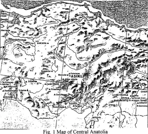
Fig. 1 Map o f Central Anatolia
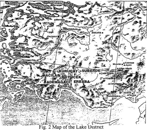
(Özdoğan and Başgelen, 1999: 87)...1 Fig. 2 Map o f the Lake District
(Özdoğan and Başgelen, 1999; 137)... 2 Fig. 3 Map o f the Marmara Region
(Özdoğan and Başgelen, 1999: 155)... 3 Fig. 4 Map o f Turkish Thrace
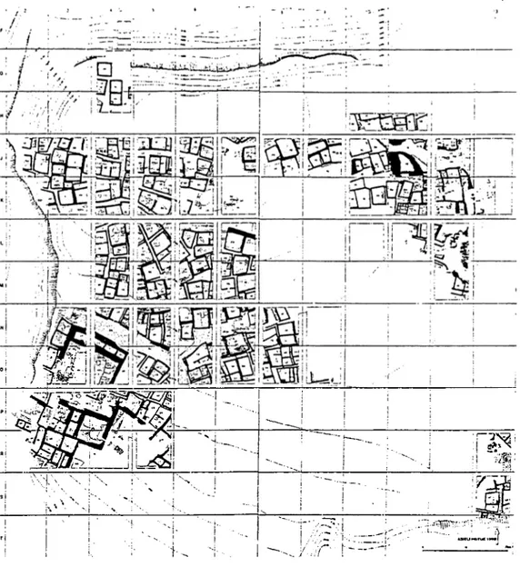
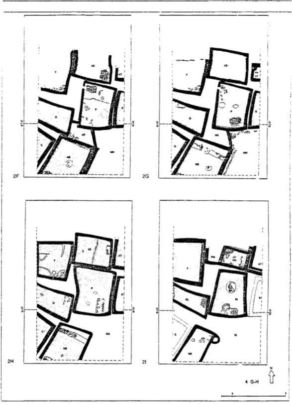
(Özdoğan and Başgelen, 1999: 169)... 4 Fig. 5 Aşıklı Hö3nik schematic plan (Esin, 1999: 90) ... 5 Fig. 6 Aşıklı Höyük schematic plans o f building phases 2B-2E
(Esin, 1999: 94) ... 6 Fig. 7 Musular architectural remains from N -0 11
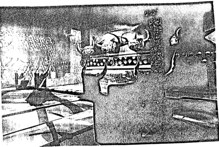
(Özbaşaran, 1999; 120) ... 7 Fig. 8 Musular red painted lime plaster floor o f Building A
(Özbaşaran, 1999; 123)... 7 Fig. 9 Can Hasan III schematic plan (TA Y)... 8 Fig. 10 Çatal Höyük -east- Level VI schematic plan
(Mellaart, 1963b; 58) ... 8 Fig. 11 Çatal Höyük -east- Level VI reconstruction
(Mellaart, 1963b: 57) ... 9 Fig. 12 Çatal Höyük -east- virtual reality reconstruction o f an elaborate
building (Hodder, 1999; 134) ... 10
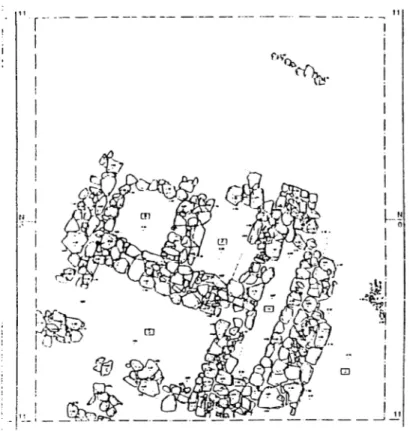
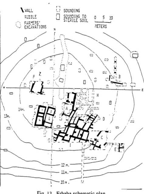
Fig. 13 Erbaba schematic plan (Bordaz, 1982: 93) 11
Fig. 14 Köşk Höyük schematic plan (TAY) ... 11
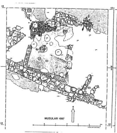
Fig. 15 Musular architectural remains from N -0 12
(Özbaşaran, 1999: 120) ... 12
Fig. 16 Hacılar plan o f EN Level V (Duru, 1999: 140) ... 12
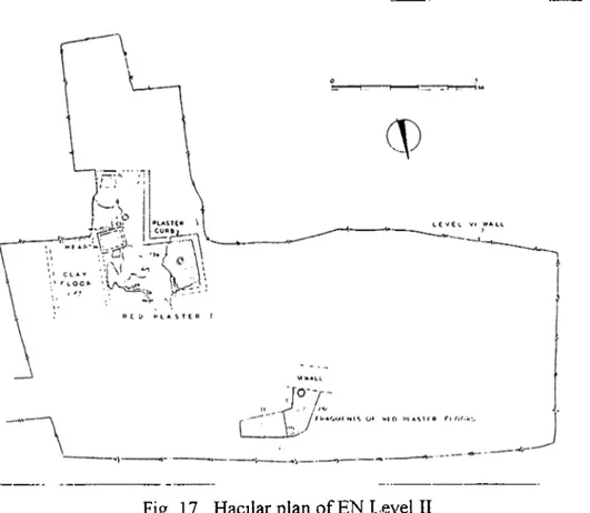
Fig. 17 Hacılar plan o f EN Level II (Mellaart, 1970b: 55) ... 13
Fig. 18 Hacılar plan o f Level VI (Mellaart, 1970b: 58-59) ... 14
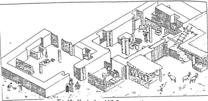
Fig. 19 (a-b) Hacılar Level VI reconstruction (Mellaart, 1970b: 62-63) ... 15
Fig. 20 Bademağacı general plan o f the settlements (Duru, 1999: 149) ... 16
Fig. 21 Bademağacı storage facility from the EN 3 settlement (Duru, 1999: 150) ... 16
Fig. 22 Höyücek plan o f the Shrine Phase (Duru, 1999: 145) ... 17
Fig. 23 Kuruçay plan of Level 12 (Duru, 1999: 141) ... 18
Fig. 24 Kuruçay plan of level 11 (Duru, 1999: 142) ... 19
Fig. 25 Ilipinar reconstruction o f burnt house from phase X (Roodenberg, 1999: 158) ...19
Fig. 26 Ihpmar schematic plan o f phases IX-VIII (Roodenberg, 1995c: 68) ...20
Fig. 27 Fikirtepe round hut with semi-subterranean floor (Özdoğan, 1999c: 178) ... 20
Fig. 28 Hoca Çeşme phase IV round buildings cut into the bed-rock (Özdoğan, 1999c: 179) ... 21
Fig.29 Hoca Çeşme phases IV-III a detail from the enclosure wall (Özdoğan, 1999c: 181) ... 21
Fig. 30 Hoca Çeşme phase III round building with paved and painted floors (Özdoğan, 1999c: 180) ... 22
Fig. 31 Hoca Çeşme phase II the first, rectangular mud slab building
(Özdoğan, 1999c: 181) ... 22
Fig. 32 Aşağıpmar Layer 6 the burnt Neolithic Building (Özdoğan, 1999c; 183) ... 23
Fig. 33 Yümüktepe silo bases o f Level XXIV (Garstang, 1953: I I I ) ... 23
Fig. 34 Çatal Höyük -east- pottery from levels X-VII (Mellaart, 1964a: 83) ... 24
Fig. 35 Çatal Höyük -east- pottery from levels VIII-II (Mellaart, 1962b; 53) ... 24
Fig. 36 Köşk Höyük pottery from Level III (Silistreli, 1985a: 137; 1986a: 178; 1990a; 104; 1990b: 27) ... 25
Fig. 37 Musular sherds and rim pieces (Özbaşaran, 1999: 126-127)... 26
Fig. 38 Hacılar “EN” sherds (Duru: 1999: 140) ... 26
Fig. 39 Hacılar Level IX pottery (Mellaart, 1970b; 243, 245) ... 27
Fig. 40 Hacılar Level VII pottery (Mellaart, 1970b: 249) ... 28
Fig. 41 Hacılar Level VIII-VII pottery (Mellaart, 1970b;247) ... 28
Fig. 42 Hacılar Level VI pottery (Mellaart, 1970b; 249, 251, 253, 263, 265, 271) ... 29
Fig. 43 Bademağacı selected pottery from EN 6 (1-5), EN 5 (6-10) and EN 4 (11-17) (Duru, 1999: 153) ... 30
Fig. 44 Bademağacı EN 4 box (Duru, 1999; 1 5 2 )... 30
Fig. 45 Bademağacı EN 3 pottery (Duru, 1999; 151-152) ... 31
Fig. 46 Höyücek pottery from the Early Settlement Phase and the Shrine Phase (Duru, 1999: 146) ... 32 Fig. 47 Kuruçay pottery from levels 13-11 (Duru, 1994b: 34, 35, 36, 43, 45,
52, 69, 76, 9 4 ) ... 33 Fig. 48 Ihpmar pottery from phases X-VII (Thissen, 1995; 114-117) ... 34-35
Fig. 49 Archaic and Classical Fikirtepe pottery (Özdoğan, 1999c; 174) ... 35
Fig. 50 Aşağıpınar white on red painted pottery (Özdoğan, 1999c; 191) .... 36
Fig. 51 Yanmburgaz typological pottery sequence of layers 5-4
(Özdoğan, 1999c; 176) ... 37 Fig. 52 Hoca Çeşme main vessel types from IV-II (Özdoğan, 1999c; 175) ...37
Fig. 53 Hoca Çeşme pottery from III-II (Özdoğan, 1999c; 190-191)... 38
Fig. 54 Bone awls and polishers (Mellaart, 1964a; 99; Özbaşaran, 1999; 125; Duru, 1994b; 213; Marinelli, 1995; 141; Özdoğan, 1999c; 184) ... 39 Fig. 55 Bone spoons/spatulae (Mellaart, 1964a; 101; Özbaşaran, 1999; 126;
Özdoğan, 1999c; 182; Marinelli, 1995; 141;Duru, 1994a; Mellaart, 1970b; 464 ... 40 Fig. 56 Bone awls and polishers in Southeast Europe (Winn and Shimabuku,
1989; 261, 263; Pyrgaki, 1987; 649; Höglinger, 1997; 71, 7 9 ) ... 41 Fig. 57 Footed miniature vessels (Duru, 1999; 147; Özdoğan, 1999c; 187;
Gimbutas, 1989; 208; Pyrgaki, 1987; 522; Gauss, 1997;
103-104)... 42-43 Fig. 58 Pintaderas (Mellaart, 1964a; 98; Duru, 1999; 152;
Gimbutas, 1989; 212; Pyrgaki, 1987; 693) ... ... 44 Fig. 59 Figurines (Mellaart, 1962b; VIII; Duru, 1999; 147; Özdoğan, 1999c;
187; Roodenberg, 1999; 162; Talalay, 1993; 7; Gimbutas, 1989; 346; Pyrgaki, 1987; 689; Hiptmair, 1997; 110-111)... 45-46
Fig. 61 A Chronological chart by Laurens Thissen
(Thissen, 2000: 2 1 2 ) ... 48 Fig. 62 A Chronological chart by Mehmet Ozdogan
(Ozdogan, 1999c: 1 9 4 )... 49
CH A PTER I
IN T R O D U C T IO N
1.1 D E Fm iN G THE “NEOLITHIC”
The term “neolithic” (New Stone Age) is used to designate a period which is characterised by several important changes. In the area described here, this is the period between approximately 9000-5000 BC., although this may vary slightly from one region to another. During these four thousand years people created a different economic and social environment based on the active manipulation o f natural resources in order to provide the nutritional bases o f their communities. The sedentism and the domestication o f species leads to the appearance of village communities. This process is often called “Néolithisation” .
1.2 EXPLAINING THE NEOLITHIC
After the mid-19“' century, scholars defined the Neolithic as a time period in prehistory. The most useful evidence is the chipped stone typology o f that time. The first attempts to define such an early period is made by Lubbock. He defined the Palaeolithic by using the fossil remains o f extinct species. Lubbock also related the Neolithic to the appearance o f a food producing economy, which relies on the domestication of certain plant and animal species by using technology o f chipped and polished stone tools (summarised after Clark, 1980: 1-2). Ever since R. Pumpelly proposed his “Oasis theory” in 1908 (summarised
after Trigger, 1995; 250-251), the Near East and Egypt have been understood as the starting point of the néolithisation process. This theory has found wider acceptance due to its application by V.G. Childe, who understood the néolithisation process as one o f the major “revolutionary” events in the history o f human civilisation (summarised after Trigger, 1995: 253). It has also been included in the textbook “Man Makes Himself’ (Childe, 1936). The discovery o f a complex neolithic culture in Jericho by J. Garstang and K. Kenyon (Kenyon,
1960 a & b) seemed to point to the Levant as a possible starting point o f the Néolithisation. The discoveries at Jericho attracted further research in this area, and further confirmation for this hypothesis was accumulated. The Iraq-Jarmo project directed by R. Braidwood (Braidwood and Howe, 1972), designed partly to disprove Childe’s “Neolithic Revolution” (1934), promoted the formulation o f a different hypothesis. It could be shown that the néolithisation process was a gradual one taking place over several steps in the “Hilly Flanks” of the Taurus- Zagros foothills where the ancestors o f the later domesticates were found. In 1968, L. Binford proposed the “Marginal Areas Theory” (summarised after Redman, 1978: 101-105). According to this approach a favorable climate at the end o f the Pleistocene enabled a constant population growth in the Epi- Palaeolithic* hunter gatherer communities. After a certain while the population growth reached the limit o f the carrying capacity o f the land. Thus, the excess population was forced to leave the original group. This branching-off group had to settle in marginal areas, where environment and resources were not as tolerant and plenty. Subsequently, the active manipulation o f the natural resources must
have been initiated in these marginal regions. With the increase of research and developing techniques, basics o f the modem day understanding of the Neolithic implies a different economic and social environment from the one o f the preceding era. During the last decades, economic and social aspects o f the Neolithic are emphasised by modern day researchers. Some o f these are Flannery (1972), Redman (1978), Binford (1983) Bar-Yosef and Meadow (1995) and Watson (1995). According to this research, the Neolithic is the result o f the active manipulation o f natural resources and the appearance of the “Mixed Economy”, which is the use o f domesticated food crops, horticulture and herd animals in addition to specialised hunting and gathering. Within this more complex economic strategy, the rise o f an organised and stratified society is inevitable. More recently, emphasis has been put on the relations between the specialised economy, the surplus production and the use of symbols (Thomas,
1991:181-82; Hastorf, 1998; 778).
The first group o f models assumes that the Neolithic changes take place in restricted areas and then diffuse to other regions. This group includes the “Oasis” theory, which postulates that people and animals were forced to live
together (after Redman, 1978: 93-95). The “Hilly Flanks” brings up the
presence o f favourable areas, where wild plants and other resources were available (after Redman, 1978: 95-97). The “Marginal Areas” theory (after Redman, 1978: 101-105), is another model in the first group. Following these, an emphasis on a gradual development was proposed with the idea that pre- Neolithic groups were already sedentary (Harris, 1990: 17-19): This group o f theories emphasises that either the southern Levant (Bar-Yosef and Meadow,
1995; 39-94) or the Zagros (Braidwood and Howe, 1972) would have been the primary regions o f the formation o f the Neolithic. In a second step, the “Wave o f Advance” theory (Sherratt, 1996; 130-140) proposes areas o f secondary Néolithisation, which would have received the Neolithic life style later, either by the colonisation o f formally sparsely occupied areas or by the diffusion o f new technologies. Some scholars (Ozdogan, 1997; 14-17; 2000; 166) try to link the collapse o f Neolithic settlements in the Near East during the PPN-C period and the contemporary increase o f settlements in Central Anatolia and the Lake District. This interpretation implies a westward movement o f parts o f the Neolithic population.
The idea o f locally developed cultures forms the second group o f theories (Ozdogan, 1992; 3-4). This view emphasises the existence of a pre-Neolithic population in a certain area, which would then undergo an independent Néolithisation process. This Néolithisation process might have been triggered by
influences from outside, such as contact with already neolithic
communities. Together with a long distance trade in obsidian, which is proven since the beginning o f the Neolithic onwards (Balkan-Ath, et al; 1999; 143), the exchange o f items likew plant seeds or domesticated animals might have taken place (Hastorf, 1998; 779).
1.3 HISTORY OF RESEARCH
Research on the Neolithic o f Anatolia began only in the 1960s. Before that, Anatolia was thought to have been void o f occupation until 3000 BC
because o f harsh winter conditions on the central plateau (Özdoğan, 1992: 2; 1995: 27-28). Therefore, Anatolia would have formed a natural barrier between the Near East and Southeastern Europe. Alternatively, it was interpreted as a landbridge between Southeastern Europe and the Near East, thus being used only as a passage without an indigenous cultural development (Özdoğan, 1995: 27; 1997: 3). The early discoveries at Pendik, Fikirtepe and Alişar were only dated to pre-Troy but there was nothing more clear (Bittel, 1960). In 1963, Çayönü, in Southeast Anatolia, was discovered. In the following year, the Central Anatolian site Çatal Höyük -east- was unearthed. However, these spectacular sites continued to be explained until the 1980s as “special purpose sites”, for example as obsidian trade posts (Silistreli, 1986: 133). Since the 1960s, many Neolithic sites were newly discovered during rescue projects in the eastern part o f Turkey. The density o f site distribution and the ingenuity o f its Neolithic culture proved the importance o f Anatolia as a formation zone o f the Neolithic. This leads to the discussion o f whether the origins o f the Anatolian Neolithic are local or go back to an impact from a primary néolithisation zone in the Levant.
The study area covered in this thesis includes Central Anatolia, Western Anatolia, North Western Anatolia and Turkish Thrace. The geographic location of the study area between Anatolia and Europe might help to understand the dynamics o f the Néolithisation in this contact zone better.
Within the study area it is possible to consider that the coastal Epi- Palaeolithic Culture in the Marmara region, the so-called “Ağaçlı Group”
(Gatsov and Özdoğan, 1994: 102, 107, 108) might have been the ancestor o f the coastal Fikirtepe Culture. In order to support this statement the similarity o f prismatic cores, round end scrapers, perforators and end scrapers from Ağaçlı (Gatsov and Özdoğan, 1994; 112-117) and the coastal Fikirtepe Culture (Özdoğan, 1999b; 173 figure 4) can be used.
A second group o f inland settlements, represented by the sites Çalca, Keçiçayırı and Kalkanli show a repertoire different from the “Ağaçlı Group” (Özdoğan and Gatsov, 1998: 209-223). The Çalca Group is thought to be an aceramic Neolithic culture.
It is possible that the earliest steps o f the Neolithic life with Çalca group were initiated after contacts with central Anatolia and the Lake District. Links between Çalca-Keçiçayın-Kalkanlı (southern Marmara) and Suberde, Keçiçayırı and Çatal Höyük -east- (for the use o f pressure flaking) can be traced in the lithic technology (Özdoğan 1999b: 212). Trade o f obsidian from Central Anatolia might have been the initial contact. Together with that trade, an exchange o f information could have happened . It is possible that this contact was made via the Aegean (sea or inland routes).
In the course o f time, the Neolithic life style would have been elaborated locally and led to the formation o f traditions of architecture and pottery in the Marmara and Turkish Thrace regions, which were different from Central Anatolia and the Lake District. The coastal sites Fikirtepe and Pendik might have been settlements, which adapted the Neolithic developments but kept
an Epi-Palaolithic life style. On the contrary, the origin o f the population o f the inland settlement Ilipinar is still unknown.
1.4 R EG IO N A L DIVISION
1.4.1 C entral A natolia (Figure 1)
The aceramic Neolithic site Aşıklı Höyük is located in the province o f Aksaray and on the bank o f the Melendiz river. The site is under excavation by Ufiik Esin since 1989 (Esin, 1991 et al; Esin, 1991 a& b; 1992; 1993; 1998;
1999).
Musular is a recently excavated site opposite Aşıklı Höyük. It has been excavated by Mihriban Özbaşaran since 1996. The proximity o f the aceramic/ceramic Neolithic site to Aşıklı Höyük brings up the possibility that Musular bears some relation to Aşıklı Höyük (Özbaşaran, 1999).
Can Hasan III is another aceramic Neolithic settlement in the province o f Karaman, which was discovered and excavated by David French between 1961 and 1970 (French, 1970).
Suberde is located on the northwestern shore o f Sugla Lake in South- Central Anatolia. The pre-pottery Neolithic site was excavated by Jacques Bordaz between 1964 and 1968 (Bordaz, 1965; 1969; 1973).
The ceramic Neolithic site Çatal Höyük is in the province of Konya, near the town o f Çumra. The site has been thought to be located on an ancient lake bed and the alluvial plain is watered today by the Çarşamba river. The discovery o f the site and the first part o f the excavations was carried out by James Mellaart from 1961 to 1965. The site is considered a “type-site” for the neolithic o f Central Anatolia. The second part o f the British expedition started in 1990 and it is still going on under the direction o fla n Hodder (Mellaart, 1962; 1963; 1966; Hodder,1999; Wolle, 2000 http://catal.arch.cam.ac.ukJ
The pottery Neolithic site Erbaba is located 13 km south o f Suberde. Jacques Bordaz moved to that settlement after the work at Suberde had been completed and excavated here from 1969 to 1982 (Bordaz, 1970; 1973; Bordaz and Bordaz, 1976; 1982).
Köşk Höyük is located at Niğde-Bahçeli and was excavated by Uğur Silistreli from 1983 to 1989. Investigations have been resumed since 1996 under the direction o f Aliye Öztan (Silistreli, 1984; 1985; 1986; 1989; 1990; Gates, 1997; 247).
1.4.2 The Lake D istrict (Figure 2)
The earliest Neolithic settlement is Bademağacı 20 km south o f Burdur. The site was excavated by Refik Duru between 1993 and 1997 (Duru, 1994a;
Höyücek is a second site located near Burdur/Bucak, which was excavated by Refik Duru. The campaigns took place from 1989 to 1992. (Duru,
1991; 1992; 1999).
Kuruçay is the first site that R. Duru excavated. The excavations were conducted between 1978 and 1988 (Duru, 1989a; 1994b; 1999).
The last site in the Lake District will be discussed in this region is Hacılar. The site was discovered and excavated by James Mellaart. The campaigns started in 1957 and continued till 1961 (Mellaart, 1958; 1959; 1960;
1961; 1970; Duru, 1989b).
1.4.3 The Marmara Region (Figure 3)
Two groups o f sites, which might pre-date the earliest excavated settlement in the Marmara region, are known from surveys only, the so-called “Ağaçlı Group” (Gatsov and Özdoğan, 1994: 97-120) consists o f coastal settlements with an Epi-Gravettian related tool industry (Gatsov and Özdoğan, 1994: 109).
The second group, the Qalca Group, are inland sites with a flake industry. These sites all show a mound formation so they are probably sedentary sites. Since no pottery is collected they are interpreted as aceramic Neolithic sites (Efe, 1995: 100).
The earliest excavated Neolithic settlement in this region is Pendik. The site is on the east coast of the Sea o f Marmara. It has been known to exist since 1908. The surface finds are in Stockholm Museum. Rescue excavations were conducted by Ş. A. Kansu in 1961. The site was excavated again by Savaş Harmankaya in 1981 and by the Istanbul Archaeological Museum in 1992 (rescue excavations). The site represents an early phase o f the “Fikirtepe Culture” (Harmankaya, 1983; Özdoğan, 1983; Pasinli et al, 1993).
Fikirtepe itself was excavated by Kurt Bittel (Bittel, 1960; 1971).
Ihpinar on the shores o f Lake İznik has been under excavation by Jacob J. Roodenberg since 1987. The site represents an inland variety of the Fikirtepe Culture” (Roodenberg, 1993; 1995 a& b; 1999; 2000 a& b; Roodenberg, Thissen and Buitenhuis 1990; Thissen, 1995).
1.4.4 Turkish Thrace (Figure 4)
The area has been investigated in terms o f remains o f prehistoric cultures since the beginning o f the 1980s. Research in Thrace is carried out by Mehmet Özdoğan. The results of these studies are quite interesting for the nature o f neolithic life in Turkish Thrace. The earliest settlement in the area is Yanmburgaz cave, which was excavated by a team led by M. Özdoğan first and then Güven Arsebük later. The cave site provides a chronological sequence, which is obtained from limited excavation, from the lower Palaeolithic to the Neolithic (Özdoğan, 1998c).
The earliest ceramic Neolithic open air settlement is Hoca Çeşme - Enez, excavated by M. Özdoğan. The site is located on the delta o f the Meriç river (Özdoğan, 1997; 1998 b&c; 1999b).
The excavation at Aşağıpınar, in the province o f Kirklareli, was a joint project by M. Özdoğan and Hermann Parzinger between 1993 and 1996 (Özdoğan, 1998c; Özdoğan, Parzinger and Kami 1998).
CHAPTER II
TH E STA TU S OF R E SE A R C H IN TH E A R E A O F
STUDY
The present theories and models do not give a comprehensive view o f the Neolithic in central, western and northwestern Anatolia, Thrace and Southeastern Europe. Therefore it is clear that there is need for a new model, which combines the present data from environmental research and the latest results o f prehistoric research in these regions. There are some restrictions on the formulation o f new models and theories. The first is the difficulty in conducting prehistoric research as well as environmental studies. There are various reasons for such difficulties, such as political and economic. Especially the rising standards o f an average archaeological survey or excavation project force scholars to build up a large team. The result is the huge budget for expenses. Moreover, in some cases, although the money is ready, political constraints appear and research projects can not be completed. If excavation or survey is going on or completed then the problem o f publication appears. The data recovered in research projects appear mostly in local languages like Turkish, Greek, Bulgarian or Rumanian, if it is published at all. Moreover, in publications, scholars are not eager to present the whole collection o f artefacts but they choose the most important pieces, the so-called “goodies” . These problems become more serious and restricting when joined with the fact that the scholars in Turkey, Bulgaria and Greece do not share information from their own areas o f
researches.^ The major reason for this is political but, fortunately, this has been overcome only recently and now there is hope that this cooperation will continue. As a consequence of this situation, regional biases appear and scholars cannot widen their horizons. In other words, the continuing dominancy o f ideas like “Wave o f Advance” (Sherratt, 1996; 130-140), “Colonisation” and so on is the result o f these biases and o f viewing evidence only from local perspectives. These prevent scholars to formulate models that cover wide areas and more complicated issues. Another problem o f prehistoric research is the minimum use o f complementary fields of archaeology. Since archaeology is a discipline that
makes use o f natural sciences like ecology, zoology, geology and
geomorphology, social sciences like sociology and anthropology and quantitative methods (statistics), there is need for various types o f data (Ozdogan, 1982; 39). The less these fields are used the less the archaeological hypotheses are correct. The case is recently improved and there is hope that future projects’ will contain some specialists from these fields. Another restriction, which is unfortunately natural and can not be prevented, is the geomorphological process (Ozdogan 1982; 39). The alluvial deposition on coastlands and along rivers and the accumulation o f soil in other areas may bury many prehistoric sites. Although some can be spotted with the help o f instruments, most o f the time excavating these requires immense manpower and monetary resources. There is a major lack o f information in the body o f prehistoric data concerning the complete absence o f Palaeolithic recoveries, except for few projects (Ozdogan, 2000; 168). Although there is a strong possibility that many sites o f this period have been
■ Fortunately, today there are the initial steps towards information e.xchange in the Research Area, among scholars. The first sign is the "Urla Conference” (Thissen. 1997) in order to overcome the
submerged, some examples o f the remainder should have been detected. When compared to Neolithic research in Turkey, Palaeolithic archaeology and related studies are no more than fingers o f a hand (Harmankaya, Tanındı and Özbaşaran, 1997: Appendix 3). The situation is not very much different in Bulgaria or Greece. The other factor preventing prehistorians from exploring coastal occupations or stations is the existence of dense Classical and Medieval centres (Özdoğan, 1982: 48-49) on the coasts o f the Marmara, the Aegean and the Mediterranean seas such as Ephesus, Miletus, Didyma’. If these sites were to be at least partially excavated, the view on the Neolithic o f these regions would change drastically because this is a coastal band, which is several kilometers wide and thousands o f kilometers long. Lastly, human intervention is the most serious reason for the loss o f information. The reason for this is not looting but in most cases people destroy these prehistoric sites during construction works and agricultural activity. An important problem here is the relatively small size of sites in Marmara and Thrace. There is no mound formation as there is in central and west-central Anatolia. These sites are close to the surface and therefore the evidence is easily lost, especially in the Marmara and the Aegean regions. These regions are the most densely occuppied areas, especially in terms o f industrial development.
narrow perspective.
^ Altliough tliere is no evidence for this statement it is clear from the present situation that there are few prehistoric research on tlie coasts.
CHAPTER III
PA L A E O -E N V IR O N M E N T A L B A C K G R O U N D
3.1 PALAEO-CLIMATE^
Today, although the latest techniques have been used for sampling, analysing and evaluating data from pollen sampling and flotation, there is a long debate on the issue o f using such information securely.^ The attempt to reconstruct climate in the past by using certain sets o f data has been viewed to be controversial. There are so many regional differences in climate (the “Micro Climates”) that a complete reconstruction is not possible.
The climatic data show three major transitions from cold and arid to hot and humid and vice versa. The most recent results indicate that there are continuous shifts in rainfall and temperature starting from ca. 21000-20000 BP (uncalibrated)**, ie. from the peak of the Last Glacial Maximum (Imbrie and Imbrie, 1986 after Sherratt, 1997: 272) to the Allerod phase between ca. 12000- 11000 BP, which is the warming up of climate (van Zeist, Woldring and Stapert, 1975: 139; Dennell, 1985: 104; van Zeist and Bottema, 1991: 122). The second
^ Starting from here, under each sub-title, the data covers the area o f study in this tliesis, which is the
Central and Southwestern Anatolia, the Mannara area and Thrace.
^ The first discussion is about the validity o f reconstruction using the evidence from few pollen cores. The questions focus on the statistical representation o f each plant type. There is greater risk that some types of plants are over-represented in pollen cores, due to pollen rains. Another major problem is the dating of each zone in a pollen core. For efficient dating the radiocarbon method is preferred. There is risk o f contamination during the core taking process. Lastly, with each new sample, data is modified.
transition, from a warmer climate back to cooler conditions takes place during the so-called “Younger Dryas”, between 12500 / 11500 and 10000 BP, which is connected to the advance o f glaciers (van Zeist, Woldring and Stapert, 1975: 139; Dennell, 1985:106; van Zeist and Bottema, 1991; 91; M oore and Hillman, 1992:482). This is the last climatically unstable period. There is a continuous increase in temperature and precipitation starting from ca. 10000 BP (Alley et. al., 1993: 527-529; Sherratt, 1997: 273; Bar-Yosef and Meadow, 1995; 44). This is the beginning of the so-called “Holocene”, the last transition from the cold to hot, arid to humid conditions.
The maximum insolation plays an important role in the warming up of Eurasia from ca. 11000 to 9000 BP (Wright, 1993: 3). These climatic data clearly show that the Mediterranean climate appeared ca 11000 years ago in the
Eastern Mediterranean (Roberts and Wright, 1993: 200) whereas in
Southwestern Anatolia arid climate was observed between 10000 and 6000 BP (van Zeist, Woldring and Stapert, 1975: 140). The continuous increase in temperature is not balanced with precipitation and in a couple o f thousand years, aridity becomes a major problem in Anatolia (van Zeist, Woldring and Stapert,
1975: 139; van Zeist and Bottema, 1991: 147; Roberts and Wright, 1993: 202).
3.2 CHANGES IN SEA LEVELS:
The global increase in temperatures and precipitation leads to the melting o f ice sheets (Lambeck, 1996; 588) and this eventually raises sea levels.
the second half o f the chapter BP (uncalibrated) will be used unless there is a calibrated BC.
Consequently, different types o f soil have been exposed, including loess soil, on which people settled in the Neolithic.’ The sea level changes have dramatic effects on the human communities during the Neolithic. The striking difference between ancient and modern shorelines is best illustrated by the Aegean- Marmara-Black Sea research (Dennell, 1985: 109; Ozdogan, 1986; 147-155; Ozdogan, 1998a: 26-29; Ozdogan, 1999c: 226) and the investigations in the Aegean (Lambeck, 1996:590-91). The first study summarises in great detail how the Marmara and Black Sea were brackish lakes during the Last Glacial Maximum. During the final Pleistocene warmth, sea levels rose; the Black Sea and the Marmara Sea were connected via the Izmit-Sapanca basin. This created saline conditions for a short time in the Marmara Sea and the Black Sea. Soon after, the sea levels dropped and the Marmara and the Black Sea returned to brackish conditions. Eventually in ca. 6000 BC, the Aegean and the Marmara, which formed one landmass until that time, were connected via the Dardanelles, and this created saline conditions in the Sea of Marmara. The Black Sea was connected to the Marmara Sea ca. 5000 BC via the izmit-Sapanca basin for the second time and this brought saline water conditions to the Black Sea. The study o f Lambeck, (1996) in the Aegean produces further details.* The sea level in the Aegean ca. 10000 BP was 54 - 44 meters lower than today (1996; 599). At that time the Cyclades were a landmass with brackish lakes, the Gulf o f Saronikos was another brackish lake, the Thermaikos Gulf was united to land, and Limnos and Anatolia were connected. Furthermore, Thrace extended 60-km further
■ This is a unifonn pattern, which is observed in the Neolithic. The sites are located on loess soil and
alluvial depositions due to easy working of land and its fertility.
south (Lambeck, 1996: 601). According to this reconstruction, the Aegean basin has been covered with water at two points; the Mirtoan Sea to the north and the Sea o f Crete to the South/Southwest, all o f which created a six km. wide channel. This made Franchthi an inland cave-site. The sea level around the cave- site was 11 meters lower than today between ca. 7610 +/- 150 and 6220 +/- 130 BP (Lambeck, 1996; 597). The sea levels in the Aegean at ca 6000 BC were 6 - 2 meters lower than today. This makes an average rise o f 0.7-1 mm per year (Lambeck, 1996: 606). Similarly, the Northwest Anatolian sea level was 50 - 40 meters lower and shifted towards north (van Zeist and Bottema, 1991; 96). The Black Sea has been accepted to be a separate system since its water is less saline (Dennell, 1985: 109).
The research on Western Anatolian lakes reveals that there had been both saline and brackish lakes (van Zeist, Woldring and Stapert, 1975: 57). A recent study by Kayan (1996; 368) shows clearly that the Holocene warmth caused a drying-up o f very large lakes mainly due to high evaporation. This exposed fertile alluvial plains. Neolithic occupation emerged on the Konya Plain, for example, after the decline in lake levels. Contrary to lower lake levels, sea levels start to increase. This balances the loss o f fertile soil on the coastland by the exposure o f alluvial plains on ancient lakebeds. Another detail in this model is the relation between the sea level in the Aegean and the depth o f river valleys; the lower the sea level is, the deeper the river valleys are cut (Ozdogan, 1982: 42; Kayan, 1996; 367). What oceanographic study and research have implied is the possibility that mainland Greece, the Aegean islands and the empty basin of the
study brings a different model for ancient coastlines.
Aegean once was connected to the Aegean coasts o f Anatolia and Greece. This points to the possibility that those large, flat and fertile lands, as observed in Thrace and the deeper river valleys (now submerged) were settled during the Epi-Palaeolithic. Moreover, the settlers in these areas were not only hunters and gatherers but also fishers. During their periodic sea journeys, they might have acted as traders since they were exploiting natural resources such as the Melian obsidian. The inland population lived near extensive lakes, preferably on terraces, hilltops and along the river systems, which fed these lakes.
3.3 NEOLITHIC FLORA AND ANTHROPOGENIC INDICATORS:
The changes in temperature, precipitation and sea levels have effects on the vegetation.
3.3.1 The End Pleistocene Flora
In the glacial periods (ca. 20000-16000 BP), steppe cover is dominant, the only sign o f forest cover is formed on coasts (van Zeist and Bottema, 1991: 121-122). Recent research supports the previous view that cold and arid climate does not favour tree growth and therefore Artemisia (steppe) type o f vegetation is widely distributed (Aytug and Gorcelioglu, 1994: 395). Non-Arboreal pollen values^ are considerably high when compared to arboreal pollen values, during the glacial periods. Only in Thessaly, as explained by Bottema (1979: 39), the value o f arboreal pollens are higher on the Aegean coast.
In the Allerod phase (ca. 12000-11000 BP), when the climate becomes warmer
^ The pollen cores are taken from Soutliwestem Anatolia (Beyşehir Lake) by Bottema and Woldring (1984) and mainland Greece (Lake Xinias) by Bottema (1979).
with increasing temperature and precipitation new types o f vegetation appears. This climate favours tree growth, and non-arboreal and arboreal pollen values are reversed. The advance o f glaciers and the cooler climate is observed during the Younger Dryas phase (ca. 12500/11500 - 10000 BP). This is the last cold phase before the final, global warming up o f the Earth, the Holocene (ca. after
10000 BP).
3.3.2 The Holocene Flora
According to the most recent reconstruction o f major lakebed pollen c o r e s , t h e Holocene flora in Anatolia (Bottema and Woldring, 1984: 123-149) and Southeast Europe (Bottema, 1979: 19-40) is as follows.
Between 10000 and 9000 be, there is forest cover on the Black Sea coast whereas woodland and forest-steppe cover exists in Southwest Anatolia, the land between coastal Black Sea and Central Anatolia, Mediterranean, Aegean, Southern Marmara and Northwestern Anatolia (Hillman, 1996:165). The Central Anatolian vegetation is a steppe and desert-steppe type.
In Thessaly and in the Kopais Basin - Boeotia the Holocene forest replaces the Pleistocene steppes. Approximately at 10680 BP and ca. at 9000 BP there is an increase in oak and mesic type trees such as elm and hazel (Roberts and Wright, 1993: 203). The Macedonian Plain is covered with oak and elm due to
The pollen cores from the Lake District lakes in Southwestern Anatolia.
high precipitation on the northern sites ca. at 9000 BP (Roberts and Wright, 1993: 203).
The reconstruction for ca. 9000 BC on the coasts o f Black Sea and Mediterranean are forest and Eu-Mediterranean deciduous oak woodland vegetation (Hillman, 1996; 191). The north west and south o f Central Anatolia is covered with oak, terebinth, park woodland and grassland. There is an expansion of steppe cover in these areas (Hillman, 1996: 191). The wild cereal spreads extensively into Central Anatolia from west and Southwest Anatolia. Steppe cover is dominant on the Central Anatolian plateau (Hillman, 1996: 191).
Forest expansion (the spread o f pine, oak and juniper woodland) and an inland arid climate are observed in ca. 8000 BP (Aytug and Görcelioğlu, 1994; 396).“ Deciduous and mixed deciduous and coniferous forest on coastlands and mountains facing to north are identified (Aytuğ and Görcelioğlu, 1994; 400). According to Bryson and Bryson (1999: 6) precipitation drops in the Çumra area and evaporation increases, therefore there is a problem o f finding fresh water. This pattern continues between ca. 8200 and 7200 BP, leading to extreme changes in annual precipitation besides lesser winter rainfall (Bryson and Bryson, 1999: 7). Steppe cover is found only in Northwest Anatolia The east of Dobrudja has steppe cover in addition to oak, hazel and elm trees at lower elevations, between ca. 8000-6000 BC (Bozilova and Filipova, 1986; 162).
" Altliough it seems to be a contradiction here, the situation is compared with the case in 12000- 11000 BP. Approximately at 8000 BP the forest cover was more extensive when compared to
12000-There is 20% increase o f arboreal pollen values between ca. 7000-5000 BC (Bozilova and Filipova, 1986; 162), which is generally known as the “Second Climatic Optimum” . The reconstruction for ca. 6000 BP consists o f forest in the Black Sea, the Marmara, the Aegean and the Mediterranean (Hillman, 1996: 165). The north, west and south o f Central Anatolia are covered with woodland (Hillman, 1996: 165).*^ The Central Anatolian vegetation is o f steppe and desert- steppe types (Hillman, 1996: 165). The vegetation on the Drama Plain in mainland Greece is o f Mediterranean type (Roberts and Wright, 1993; 202-203). The intensive food production activities in the Neolithic have a negative impact on the vegetation and soil.^^ Forest clearance is the major indication o f agricultural and pastoralist activities. In some cases there is evidence*'* for over- grazing, which points to the fact that large flocks o f sheep, goat and cattle are taken to grassland. The sign o f Neolithic deforestation is widely encountered in the Central Anatolian plateau, South/Southwest Anatolia and North Anatolia. The best indication o f this is the so-called “Beyşehir Occupation Phase” (zones 3 -sub-zones a to d- and 4 o f the Beyşehir pollen core) (Bottema and Woldring, 1984: 140).*^ This is identified with the sharp decrease o f arboreal pollen values in the pollen cores (Bottema and Woldring, 1984: 146). Uniformly, in the whole o f Anatolia, arboreal pollen values decrease and these are replaced by
non-11000 BP.
The difference between “forest” and “woodland” is the sparser tree cover of the latter, when compared to the first one.
Forest clearance is a serious threat even for our modem world societies. In the Neolithic, especially with increasing population, the motive for more food surplus forces people to cut woodland in order to open farmlands. In the long tenn, this factor forces the occupants to abandon the settlement.
The so-called “Beyşehir Occupation Phase” from the Beyşehir II pollen core.
There is a long debate on the radiocarbon dates from these zones. Therefore scholars hesitate to
arboreal pollen values (Bottema and Woldring, 1984; 146-8; Behre, 1990: 221; Roberts, 1990; 60-61). A similar situation is observed in mainland Greece (Bottema and Woldring, 1984: 147). There is evidence o f forest clearance and replacement o f oak by marshland in the Kopais Basin (Allen, 1990: 178), o f silting up o f valleys and deforestation from the Southern Argolid (van Andel and Zangger, 1990: 143), o f cutting woodland in the Peneios Plain (van Andel and Zangger, 1990; 148) and o f deforestation and increase in non-arboreal pollen values in the Argive Plain (Jahns, 1990; 335-338). In Southwest Bulgaria non- arboreal pollen values are higher and pastureland deforestation is clear (Bozilova and Tonkov, 1990; 329).
C H A P T E R IV
THE D E V E L O PM E N T OF A R C H IT E C T U R E IN C EN TR A L
AN D W E ST E R N A N A T O L IA , M A R M A R A R E G IO N A N D
T U R K ISH TH R A C E
4.1 THE ACERAMIC ARCHITECTURE m SOUTH-CENTRAL ANATOLIA
Evidence for the development o f the aceramic architecture derives from Aşıklı Höyük, Musular, Can Hasan III and Suberde.
The type-site of Aşıklı Höyük (Figure 5) is surrounded by a fortification wall which has so far been uncovered in the Southeastern part (Esin, 1999: 125). Two gates give access to the interior o f the settlement, which is subdivided by streets into several quarters. Densely packed trapezoidal one or two room buildings (Figure 6) are arranged according to an “insula system” (Esin, 1992: 134) where each house unit remains in a pre-defined space over several phases of renewal. Building material is mud brick without stone foundations. The standard installation is a hearth at the north east comer o f the room (Esin, 1999: 118). Houses are constructed without exterior doorways and the space between two neighbouring houses is usually too small for circulation thus the roofs must have been the major traffic and out-door working space. The so-called “T Complex” in the South West o f the settlement is constmcted from tufa stone using a
casemate wall system (Esin, 1993: 84). This complex might be interpreted as a public building (Esin, 1993: 88).
Musular is a flat settlement, which is located partially on a slope whereas the other half stands on tufa (Özbaşaran, 1999: 149). The aceramic Neolithic layer at Musular reveals a single quadrangular mud brick structure (Figure 7) with a well-preserved west wall (Özbaşaran, 1999: 150). Inside the building, several flat stones surrounded with pebbles and covered with mud brick probably formed the bases for wooden posts. The floor was plastered and bears red burnished paint (Figure 8). This building might be interpreted as a special purpose structure and is compared to Building T at Aşıklı Höyük (Özbaşaran,
1999: 150).
In another trench, a round hearth with a pebble pavement has been discovered together with a pavement made of flat and largish stones (Özbaşaran,
1999: 149). No building structure linked to the hearth has been found.
At Can Hasan III pise and mud brick structures without stone foundations, which are arranged according to an agglutinative general plan, were found (Figure 9). They form two-roomed rectilinear dwellings, which cluster around centrally located courtyards. Passageways connect courtyards and rooms inside buildings. Beaten earth floors and pise walls are plastered with clay and some bear traces o f red paint. Benches, hearths and ovens built into walls are widely used installations! During two renewal phases new structures were built
Suberde covers an area o f 1500-2000 square meters, which have been investigated by small soundings only. Due to this limited excavation, no site plan is available. The earliest occupation phase, the so-called “Lower Prehistoric Period”, consists of clay floors and fragmentary mud brick walls. Some o f the wall fragments with right angle comers suggest the existence o f rectangular dwellings. Earth benches line the walls. Burnt debris shows that the superstmcture o f the dwellings was made o f mud and cane (Bordaz, 1969; 46- 47). In between the dwellings round pits with plastered walls have been dug to a depth o f 15-20 cm. They might be interpreted as either hearths or as storage bins. The “Upper Prehistoric layer” is badly preserved due to later disturbances. No complete plans have been retrieved, but the fragmentary walls also belong to rectangular stmctures, some of them with internal partition walls. Plaster and stone are used together. Reddish brown mud shows a similar function to mud brick whereas light brown mud is used like mortar (Bordaz, 1969: 46). Floors are made from either plastered or smoothed earth.
4.2 COMMENTS ON THE ACERAMIC ARCHITECTURE
The earliest Aceramic Neolithic architecture recorded consists of rectangular or trapezoidal buildings with one, two or three rooms. The constmction material is pise in Can Hasan III and in Suberde, whereas in Aşıklı Höyük mud brick is used. Evidence from Suberde shows that organic material was used for the upper part and the roof o f the buildings. At least in Aşıklı Höyük the densely built stmctures may have shared roofs.
Amongst the common features in the area, red painted floors point to the use o f certain rooms as shrine or special purpose buildings. Exceptional structures such as the casemate Building T at Aşıklı and maybe the Musular dwelling show the concept of public constructions as well. An enclosure wall has so far only been recorded at Aşıklı Höyük.
4.3 THE CERAMIC NEOLITHIC ARCHITECTURE IN CENTRAL ANATOLIA
4.3.1 Çatal H
öyük-east-The “type site” Çatal Höyük -east-, reveals densely packed agglutinative single or multi room structures, which are built o f mud brick without stone foundation (Figure 10). Interior passages connect the rooms whereas there are no doorways in the outer walls. Probably the dwellings (Figure 11) were entered from the roof (Mellaart, 1962; 46-49). These flat roofs may have the function o f working space as well as courtyards (Mellaart, 1962: 49). Some o f these structures (Figure 12) have been interpreted as special purpose buildings (“shrines”) according to their architectural decoration (Matthews, 1997).
4.3.2 Erbaba
From three levels o f habitation, eleven house units with a total o f twenty- eight rooms were excavated (Figure 13). The best-preserved plan is from the uppermost level. Dwellings are densely packed in an agglutinative way with the long axis o f each house oriented towards the northeast. Foundations are set into trenches in which three rows o f limestone blocks set into mud mortar are
aligned. Walls are double skinned and filled with earth. Roofs are made of timber and reed and sealed with mud (Bordaz, 1970: 60). Since the rooms are small there is no need for separate roof supports. Some rooms show internal buttresses, which might be either wall re-enforcement or bases for wooden beams, which belong to the roof. Floors are made from beaten earth or plaster. The usual colour o f the plaster is grey. Interior passages lined with partition walls have been observed but the most possible entrance into the houses is from the roofs (Bordaz and Bordaz, 1976: 39).
4.3.3 Köşk Höyük
Three Neolithic occupation levels at Köşk Höyük revealed rectilinear, single or two room mud brick buildings with stone foundations (Figure 14). Walls, floors and doorways are plastered with clay (Silistreli, 1986: 129). The roofs are made of reed and then covered with mud. Besides dwelling units, separate depots and granaries are found (Silistreli, 1984: 84). Ovens are located on the central axis o f the rooms. A hard plaster (Silistreli, 1990: 95) distinguishes separate working areas. One rectangular two room building with a bench inside reveals several elaborate finds and is thus interpreted as “shrine” (Silistreli, 1989: 62).
4.3.4 Musular
The last phase o f occupation at the site belongs to the late Neolithic and consists o f a massive, stone-built complex (Figure 15) with two cell-like rooms (Özbaşaran, 1999: 151). One o f its walls stands on the bedrock whereas the others are based on an artificial surface made o f clay and earth. Pits and working
areas with grinding stones, polishing stones and some tools can be distinguished inside the structures (Özbaşaran, 1999; 151).
4.4 COMMENTS ON THE CERAMIC NEOLITHIC ARCHITECTURE
Architectural evidence excavated in Central Anatolia points to a common sphere o f traditions at Çatal Höjoik -east-, Köşk Höyük, Erbaba and probably also in Suberde. Settlement planning is clearly visible from the agglutinative buildings at Çatal Höyük -east-. This tradition is linked to the building style at the aceramic site Aşıklı Höyük. The standardised orientation and the axial arrangement of certain interior details are features that are observed at Çatal Höyük -east- and Köşk Höyük. In Erbaba the agglutinative building style also requires the same orientation to be observed. Further shared characteristics are the roof entrances, interior passages, plastered floors and walls, granaries and depots located inside the dwellings. The shrine at Köşk Höyük can be compared to the ones from Çatal Höyük -east-.
Musular, on the other hand, does not follow the same tradition. The site is set apart by the use o f stone foundations and o f double skinned mud brick wails and especially by the Late Neolithic stone built complex.
4.5 THE CERAMIC NEOLITHIC ARCHITECTURE IN THE LAKE DISTRICT
The type-site Hacılar provides us with a long and reliable sequence. Therefore the site is described first, although chronologically (Bademağacı- Höyücek-Kuruçay-Hacılar) it is the latest settlement.
4.5.1 Hacılar
The earliest Neolithic**^ layers are exposed in 150 square meters trench only. In this sounding seven building layers (VII - I) could be distinguished, whereby the lowermost two are only known by red painted plaster floors. From level V onwards, the architecture consists mainly o f small rectangular rooms with thin mud brick walls. These mud bricks are greenish and straw tempered and are set directly on the ground (Figure 16), (Mellaart, 1970; 3-4). Mud plaster is the major binding element in these walls. Some thicker walls stand on stone foundations. Floors are covered with mud plaster, although in some rooms, they are covered with a pebble pavement underneath a lime plaster, which is painted red and burnished. Inside the dwellings as well as in the courtyards oval ovens and silos are found (Mellaart, 1970: 5-7). From level II onwards, walls become thicker and stronger and rectangular ovens come into use (Figure 17). At the end o f level I, the early Neolithic settlement is abandoned for several hundred years.
According to Mellaart, the earliest phase (aceramic VII to I) is truly aceramic. Subsequent investigations north o f the mound revealed painted floors similar to the ones described by Mellaart.
The following pottery Neolithic occupation in Hacılar partly overlays the early Neolithic layers. Four building levels, IX to VI, belong to this occupation.' O f these levels, the earliest two, IX and VIII, are only poorly documented. Fragmentary walls with corners must have belonged to rectangular rooms o f which carefully plastered and painted floors are preserved. Many postholes are recorded so that the existence o f wooden structures has to be considered (Mellaart, 1970; 16). An oval installation is recorded from one o f those rooms (Mellaart, 1961: 71). Level VII represents an earlier phase o f the level VI occupation, distinguished by the use o f a pebble paved courtyard floor. The burnt level VI settlement is well preserved and exposed on a large scale (Figure 18). Two sub-phases, VI A and VI B, can be distinguished by floor renewals. The settlement consists of large multi-room houses, which are separated by open spaces or communal courtyards (Figure 19 a & b). Four house complexes have been distinguished each composed from two rooms arranged in an “L” shape. Private courtyards can be attached to these house complexes. All houses follow the east-west axis (Mellaart, 1970: 21). They are built from one-meter thick plano-convex mud brick walls on stone foundations. The walls seem to be strong enough to support a second storey (Mellaart, 1961: 42-43). Post supports found inside the rooms also point to the existence o f an upper floor. The exterior walls meet at right angles, so there is no internal buttressing. In terms o f the interior organisation, they reach a certain level o f standardisation. Plastered rows o f stakes separate the oblong large room into sections. In these partitions there are
Small amounts of pottery were collected from each of these floors (Dura. 1989b: 101).
The numbering o f the building levels was done separately for both the assumed “aceramic” and the “pottery Neolithic” levels. Therefore, the same level numbers occur twice. This will be distinguished in the rest of the text by adding “PN” in front o f the level number for the later pottery Neolithic layers.