Cilician Chronology Group
A Comparative Stratigraphy of Cilicia
Results of the first three Cilician Chronology Workshops
https://doi.org/10.1515/aofo-2017-0013
Abstract: This article presents a preliminary comparative stratigraphy of excavated sites in Plain Cilicia and one in Rough Cilicia. It is the outcome of three workshops held in 2014, 2015 and 2017. Plain Cilicia at the junction of Anatolia, Syro-Mesopotamia and Cyprus is one of the most fertile regions of the Ancient Near East. In recent years, archaeological research in the region has intensified, re-opening questions of chronology. The comparative stratigraphy discussed in the workshops is presented here in form of a gazetteer of the participat-ing sites and a chart. This is to be understood as a first step towards a more comprehensive chronology. Keywords: Cilicia, chronology, comparative stratigraphy
Introduction (Fig. 1)
Plain Cilicia (gr. Kilikia Pedias, lat. Cilicia Campestris) is an alluvial fan covering approximately 8000 km2
and one of the most fertile regions in modern-day Turkey.1It is located at the junction of Anatolia,
Syro-Mesopotamia and Cyprus, defined by natural borders: the Taurus Range to the west and north, the Amanus to the east and the Mediterranean to the south. The plain is divided into a western part on the coast (Çukurova)
and an eastern inland part (Yukarıova). Natural passes through the mountains give access to the neighbouring
regions: the Göksu (gr. Kalykadnos) Valley connects Plain to Rough Cilicia (gr. Kilikia Tracheia, lat. Cilicia Aspera) to the west, the well-known Cilician Gates (Gülek Boğazı) north of Tarsus, the route from Kozan via
Corresponding author: Mirko Novák, Bern University, Institut für Archäologische Wissenschaften, Länggassstr. 10, CH-3012 Bern, Switzerland, E-Mail: [email protected]
Anna Lucia D’Agata, Consiglio Nazionale delle Ricerche Roma, Italy Isabella Caneva, Salento University, Lecce
Christine Eslick, Sydney, Australia
Charles Gates, Bilkent University Ankara, Turkey Marie-Henriette Gates, Bilkent University Ankara, Turkey K. Serdar Girginer, Cukurova University Adana, Turkey Özlem Oyman-Girginer, Cukurova University Adana, Turkey Éric Jean, Hittit University Çorum, Turkey
Gülgün Köroğlu, Mimar Sinan University Istanbul, Turkey Ekin Kozal, Onsekiz Mart University Çanakkale, Turkey Sabina Kulemann-Ossen, Bern University, Switzerland
Gunnar Lehmann, Ben-Gurion University of the Negev, Be’er Sheva, Israel Aslı Özyar, Boğazıçı University Istanbul, Turkey
Tülay Ozaydın, Mersin, Turkey
J. Nicholas Postgate, Cambridge University, England FatmaŞahin, Cukurova University Adana, Turkey Elif Ünlü, Boğazıçı University Istanbul, Turkey Remzi Yağcı, Dokuz Eylül University Izmir, Turkey Deniz Yaşin Meier, Bern University, Switzerland
1 On the modern and historical geography of Plain Cilicia, see Rutishauser (in press) and Novák/Rutishauser (2017); for a historical overview see Novák (2010).
Fig. 1: Map of Plain Cilicia with sites mentioned in the text, and some modern cities (© Susanne Rutishauser, Bern University).
Feke and the Gezbel Pass (Hittite-Kizzuwatnean Caravan Route)2connect the region with the central Anatolian
plateau, the Bahçe (Amanus Gates) and the Belen Pass (Syrian Gates) with theİslahiye Plain and the Amuq
respectively. A number of rivers, originating in the Taurus Mountains, cross the lowlands and discharge into the Mediterranean: the four most important are the Göksu (gr. Kalykadnos), the Berdan or Tarsus Çayı (gr. Kydnos), the Seyhan (hitt. Šamri/Sapara, gr. Saros) and the Ceyhan (hitt. Puruna (?), gr. Pyramos). The fertile alluvial plain allows both dry-farming and irrigation agriculture which have supported a dense settlement pattern since the Neolithic period.
The archaeological richness of the region has been well-known since the early excavations by Hetty
Goldman in Tarsus-Gözlükule,3John Garstang in Mersin-Yumuktepe,4Kazanlı Höyük and Sirkeli Höyük,5and
Helmuth Bossert in Karatepe-Aslantaş6 and in Misis7, as well as the Cilician survey of Veronica
Seton-Williams,8all undertaken before the 1960s. Since then, the most extensive surveys of Eastern Cilicia (Ceyhan
2 Girginer et al. (2017: 448). 3 Goldman (1956). 4 Garstang (1953). 5 Garstang (1937). 6 Bossert (1948).
7 Bossert (1957); Bossert apud Budde (1969: 19). 8 Seton-Williams (1954).
and Kozan Plain) were carried out by Mustafa H. Sayar and K.S. Girginer between 2004–2006.9Excavation has
recently intensified in the region, although few projects have focused on new sites (Fig. 1). Nevertheless, new
data has been steadily accumulating, providing insights into the cultural history and archaeology of the Cilician Plain. The importance of a solid chronology based on a thorough comparative stratigraphy of all investigated sites is apparent.
The purpose of a series of workshops was to initiate a dialogue among active archaeological projects in the region. The first Cilician Chronology Workshop took place in the expedition house of Sirkeli Höyük on
31stJuly–1stAugust 2014. It was followed by a second on 29th–30thAugust 2015 in Tatarlı and Sirkeli, and by a
third from 30thMay–1stJune 2017 in the archaeological research centre of the Tarsus-Gözlükule Excavations.
Participants from the following archaeological projects have decided to collaborate on a preliminary chronol-ogy as a base for further investigations: Porsuk-Zeyve Höyük (Dominique Beyer and Aksel Tibet, 2014), Mersin
Soli Höyük (Remzi Yağcı, 2014, 2015, 2017), Mersin-Yumuktepe (Éric Jean, 2014, 2015, Tülay Özaydın, 2017),
Tarsus-Gözlükule (Aslı Özyar and Elif Ünlü, 2015, 2017), Tarsus Museum (Mehmet Çavuş, 2017), Kırıt (Erkan
Alkaç and Deniz Kaplan, 2017), Adana-Tepebağ (Fatma Şahin, 2017), Misis (Anna Lucia D’Agata, 2017), Sirkeli
Höyük (Mirko Novák 2014, 2015, 2017, Ekin Kozal, Sabina Kulemann-Ossen, 2014, 2015, Deniz Yaşin Meier,
2015, 2017), Tatarlı Höyük (K. Serdar Girginer and Özlem Oyman-Girginer 2014, 2015, 2017, Hayriye Akıl, 2014,
2015, Ayça Özcan-Gerçek and M. Cem Fırat, 2017), Kinet Höyük (Marie-Henriette Gates, 2014, 2017, Charles
Gates 2017, Gunnar Lehmann 2014, 2017), the Cilicia Epigraphic Survey (Mustafa Sayar, 2015 and 2017), the
Neolithic Survey (Orkun Hamza Kaycı, 2017), and the Mopsos Survey Project (Ann Killebrew, 2014).
The short gazetteer below gives an overview of all these sites and excavations with a short bibliography for further reading. The sites are presented in geographical order from west to east. The contributors for each site are indicated and the final chart is a common outcome of all mentioned authors and the entire teams working on the included sites.
Kilise Tepe
J. Nicholas Postgate (University of Cambridge)
Short Excavation History
Excavated from 1994 to 1998 by a joint project of the Silifke Museum and the British Institute at Ankara (Ş. Basal, İ. Öztürk, J.N. Postgate). Excavation restarted in 2007 and the project closed in 2013 (J.N. Postgate, M.P.C. Jackson).
Topography and Excavation Areas
Excavation in the Bronze and Iron Age levels was largely confined to the north-western corner of the mound,
and to a 40 m strip trench across the centre of the mound, south of the foundations of the Byzantine church.
Bibliography
Postgate/Thomas 2007; Postgate 2008; Bouthillier et al. 2014; Postgate online
General Periodization
Period Dates
Phases Excavated
Northwest Corner Central Strip
Level NW B. Stele B. I18 Level
Late Bronze Age 1500–1350 III IIIa–b 3 IIIc IIId Phases 15–12 IIIe 1350–1250 II IIa Phases 11–7 IIb.i IIb.ii Terminal Late Bronze Age 1250–1150 IIc IIc
IId IId Phases 6c–a
Iron Age 1150–800 IIe 2 2e Surfaces 5e–a Surfaces 4–2 800–650 IIf 2f Surface 1 IIg-h 2k Byzantine and Hellenistic I 1
Stratigraphy and Characteristics
Levels V, IV and III were only investigated at the NW corner, Levels V and IV (EBA and MBA) only in a small sounding. Level III had five phases, of which the penultimate (IIId) is best attested. This was probably a forerunner of the Level II Stele Building, with some public role. Level IIa-d are phases of the so-called Stele Building which clearly had a ritual and storage function, and was destroyed twice by fire (IIc and IId). After this occupation of the NW corner only survives in fragmentary form, ceasing in Middle/Late Iron Age.
Excavation of the Central Strip was designed to recover stratified evidence bridging the end of the Bronze Age and the later Iron Age phases at the site. The levels here bear Arabic numbers. Level 1 here = Level I at the NW corner, but Level 2 starts later than Level IIa, as Level 3 seems to be contemporary with the earlier phases of the Stele Building.
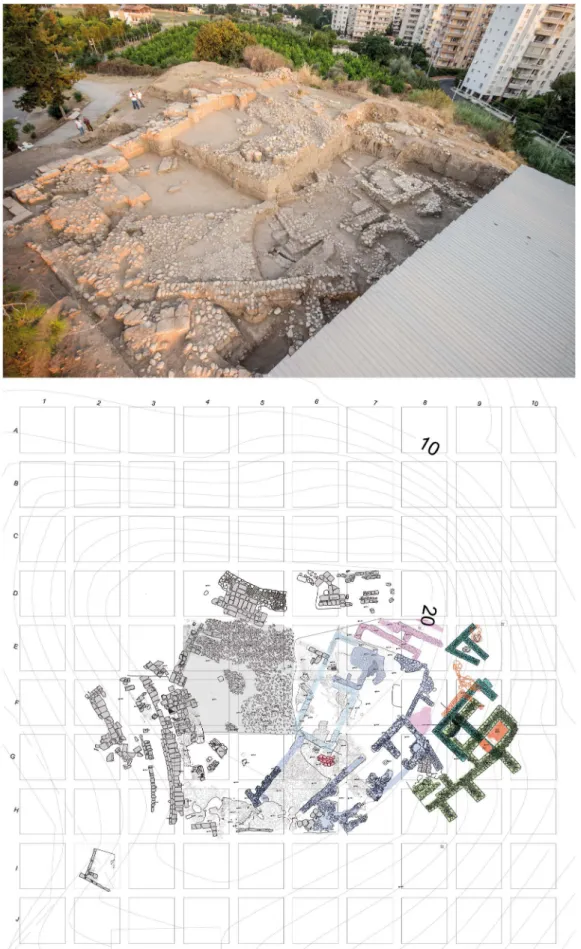
Mersin Soli Höyük (Fig. 2)
Remzi Yaǧcı (Dokuz Eylül University, İzmir)
Short Excavation History
Systematic archaeological excavations at the ancient city of Soli-Pompeiopolis have been conducted by
Remzi Yağcı under the auspices of the Ministry of Culture and Tourism, by Mersin University (1999–2003) and
Dokuz Eylül University since 2004. The main goal of the excavation project at the mound is to establish a chronology and stratigraphy of the settlement and to address some specific questions on Cilician archaeology through systematic excavation and recording.
Topography and Excavation Areas
Soli Höyük is situated 11 km west of Mersin. It has been possible to excavate only the northern part of the mound due to the damage caused by later settlements. Buildings related to a modern military garrison are located on the mound and the Roman Pompeiopolis theater encroaches on the northwest of the mound. The archaeological data obtained since the start of excavations at Soli Höyük show that the city was an active harbor city from the second millennium BC onwards. Soli Höyük was situated at the border between
Kizzuwatna in the East and Tarḫuntašša in the West and had thus an important defence system in the 15th
century BC, with casemate fortifications. Written materials discovered at the mound and dating to the 15th–
13th centuries BC contained Luwian names. The mound offers a wide range of architectural remains and
materials that date from the Hittite Imperial period to the Roman period. Excavations at Soli Höyük are currently also carried out in squares G4, G5, G6, F6, F7, E6, E7, E8, and H6, in Archaic levels.
Bibliography
Yağcı 1999, 2003, 2006, 2007a, 2007b, 2008, 2010, 2013.
General Periodization
Soli Höyük Conventional
Period
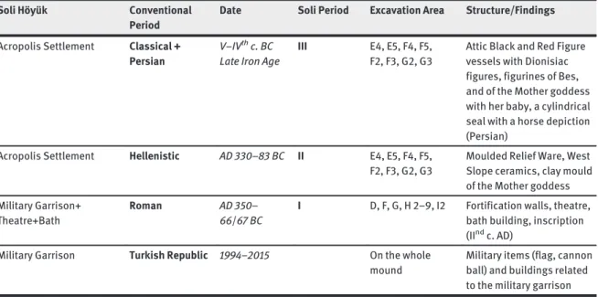
Date Soli Period Excavation Area Structure/Findings
Acropolis Settlement and Garrison Hittite Imperial Period A city of Kizzuwatna (Egara?Ellipra? Ura?)
XV–XIIthc. BC VI.2 E9, F9, G9,
G10, F9, F8, H8, G8
RLWM (arm shaped, jug, pilgrim flasks), drab ware with pot marks, a double faced stone mould (for axe and sickle) , Cypriot WS II cups, XV–XIIIthc. bullae
and a stamp seal-impressed cup handle (Muwazi, Targasna and Parnapi), fortification walls Acropolis Settlement End of Hittite
Imperial Period Sea Peoples? Destruction layer
XIIthc. BC VI.1 E9, F9, G9,
G10, F9, F8, H8, G8
Burnt layer (fire): burned and broken jars in context, scattered LH IIIC bowls in other layers
Hiatus Acropolis Settlement Late Geometric,
Cypro-Geometric + Cypro-Archaic and Orientalizing Period (Rhodian Colony) Mid VII– VIthc. BC V G4, G5, G6, F6, F7, E6, E7, E8,
Megaron (temple?), Geometric ceramics with concentric circles, amphorae, amphorae ornamented with sacred prostitution scenes, Bird Bowls, Orientalizing craters (4thquarter of
7th century)
Acropolis Settlement Archaic (Rhodian Colony)
VI–Vthc. BC IV G4, G5, G6, F6
F7, E6, E7, E8, H6
Architectural terracottas, megaron (temple?), Wave Line Ware, Ionian bowls, lekythoi
Soli Höyük Conventional Period
Date Soli Period Excavation Area Structure/Findings
Acropolis Settlement Classical + Persian
V–IVthc. BC Late Iron Age
III E4, E5, F4, F5, F2, F3, G2, G3
Attic Black and Red Figure vessels with Dionisiac figures, figurines of Bes, and of the Mother goddess with her baby, a cylindrical seal with a horse depiction (Persian)
Acropolis Settlement Hellenistic AD 330–83 BC II E4, E5, F4, F5, F2, F3, G2, G3
Moulded Relief Ware, West Slope ceramics, clay mould of the Mother goddess Military Garrison+
Theatre+Bath
Roman AD 350–
66/67 BC
I D, F, G, H 2–9, I2 Fortification walls, theatre, bath building, inscription (IIndc. AD)
Military Garrison Turkish Republic 1994–2015 On the whole mound
Military items (flag, cannon ball) and buildings related to the military garrison
Stratigraphy
Tab: Radiocarbon date: Beta Analytic Inc. (2016)
Soli Phase Context Results Cal BC Beta
VI.2 Contemporary with fortification walls
1. 2-sigma calibrated result (95 % probability):
Cal BC 1440 to 1380
2. 2-sigma calibrated result (95 % probability):
Cal BC 1455 to 1385
1-249333 2-445891
VI.1 Contemporary with end of Hittite Empire Period/Destruction layer: Sea Peoples?
2-sigma calibrated result (95 % probability):
Cal BC 1215 to 1015
445892
V Contemporary with Tarsus “Assyrian period”
2-sigma calibrated result (95 % probability):
Cal BC 750 to 685 / 665 to 640 / 590 to 405
445893
Mersin Yumuktepe (Fig. 3)
Isabella Caneva (Salento University, Lecce), Éric Jean (Hitit University, Çorum), Gülgün Köroğlu (Mimar Sinan University, Istanbul), Tülay Ozaydın (Mersin)
Short Excavation History
Nearly fifty years after the end of the British research in 1947 (Garstang 1953), excavations were resumed in 1993 at Yumuktepe by an Italo-Turkish team from the universities of Istanbul (Veli Sevin) and La Sapienza, Rome (Isabella Caneva). Since 2001, the excavation has been directed by Isabella Caneva (Salento University),
with Gülgün Köroğlu, Çiler Altınbilek and Éric Jean as successive co-directors. The new research project has
aimed to reconstruct the Cilician cultural evolution from the earliest village farming groups (Neolithic) to the development of complex societies (Chalcolithic) and urban settlements (Hittite, Roman and Medieval).
Topography and Excavation Areas
Yumuktepe is a 5 ha mound, 23 m high, located in the north-western periphery of the city of Mersin. Garstang’s
research focused on the north-western quarter of the mound, while the new excavations have been conducted with synchronous field operations at different elevations, on top of the mound, in a southern trench, and in the north-western area, right at the southern edge of the old exposure.
Bibliography
Breniquet 1995; Caneva/Köroğlu 2010; Caneva/Sevin 2004; Garstang 1953; Jean 2006; Köroğlu 1998; Manuelli
2009.
General Periodization
Garstang distinguished 33 levels labelled in Roman numerals, from newest to oldest. Using the same labelling system, the current excavations have led to a re-evaluation of the stratigraphic sequence of the prehistoric levels, with a much more detailed sequence.
Periodization Approximate Date Levels (Garstang)
Early Neolithic 7000–6100 BC XXXIII–XXVIII
Middle Neolithic 6100–6000 BC XXVII–XXVI
Late Neolithic 6000–5800 BC XXV
Final Neolithic 5800–5500 BC XXIV
Ḥalaf Culture
Early Chalcolithic 5500–5000 BC XXIII–XX
Middle Chalcolithic 5000–4500 BC XIX–XVI
Late Chalcolithic 4500–3800 BC XV–XIV
Corresponds to LateʿUbaid Culture
Early Bronze Age 2800–2000 BC XIII–XII
Middle Bronze Age 2000–1550 BC XI–X–IX (early excavations)
Late Bronze Age 1550–1200 BC VIII/VII–V (early excavations)
IX–V (new excavations: southern Trench)
Middle and Late Iron Age 900–350 BC IV–III
Late Roman/Early Byzantine 4th–7thc. AD II (?)
Middle Age 1000–1300 AD I
Stratigraphy and Characteristics
The Neolithic settlement (north-western exposure)
The Neolithic sequence, only tested through small soundings during the British excavations, has now been
intensively explored over 10m-thick deposits and an extensive area (400 m2), uncovering traces of wattle and
daub structures, lighter shelters, storage pits and bins and areas for outdoor activities. The most characteristic pottery in the earliest phase consisted of thin-walled, brown, burnished hemispherical cups, often decorated with fine impressions. Interesting findings were large stamp seals or pintaderas, of bone or of soft stone, bearing geometric motifs on the flat surface and a handle on the back. Dated to 6600 cal. BC, these stamps are among the earliest ever found and might reflect a form of collective storing, perhaps related to seasonal
transhumance. The following Middle Neolithic phase (6100–5800 BC) showed a solid architecture with stone
foundations and new pottery types, with the classical Dark Faced Burnished Ware (DFBW), black or grey, and an orange, unburnished, coarse ware. The DFBW vessels were small and finely finished, probably reserved for serving and consuming food, while the orange pots were bigger and coarser, probably used as storage jars. In the Late Neolithic phase (5800 BC), houses had rounded corners and were surrounded by dozens of stone-paved cylindrical silo structures. A peripheral graveyard extended in a terraced area on the slope of the mound. Pottery was characterized by different-sized vessels, with red or brown painted motifs on a light-coloured surface. Personal ornaments, mainly necklaces of stone disk-beads, were found in the graves.
The Chalcolithic“town” (north-western and southern exposures)
At a higher elevation, in the same north-western sector of the mound, excavations concentrated on the Chalcolithic level XVI, well known for its fortification wall, and that immediately above, which is ascribed to
Garstang’s level XV. In level XVI, the two-roomed contiguous houses that constitute the fortification wall were
found to continue south of the previously excavated structures, in a symmetrical arrangement which appeared to cover the entire contour of the mound, with a second monumental gate being located almost opposite the one discovered in the old excavations. It was also discovered that the settlement extended over a wide area, outside the citadel, with dwelling houses set at various elevations on the slopes of the mound, on either side of a street. No difference appeared in either pottery or implements inside and outside the citadel, with a ceramic assem-blage consisting mainly of gourd-shaped medium-sized jars with black geometric motifs on a cream surface. The first evidence of metallurgical activities was discovered in the citadel, with smelted copper implements, minerals, crucibles and slag, suggesting that specialised forgers were acting inside the citadel.
As for level XV, the newly discovered monumental building has been ascribed to level XV in Garstang’s
stratigraphy for its direct superposition on level XVI, although nothing similar to it was found in this level in the old excavations. The structure was erected above a thick platform of mudbricks, which sealed the citadel. It consists of a multi-roomed complex, with a large rectangular hall in the middle. The tripartite plan recalls the ʿUbaid tradition, which is also reflected in other architectural elements, such as niches and buttresses. The rooms were paved with mudbricks and contained thousands of potsherds and complete bowls, all similar in shape, size, ware and surface treatment, like the mass-produced bowls that characterise the Syro-Anatolian regions in the second half of the fifth millennium BC. Noteworthy findings consisted in a clay sealing and a
peculiar pot that is quite similar in shape, ware and decoration to contemporaryʿUbaid Iranian beakers. These
findings, combined with the mass-produced bowls, testify to a fairly developed organisation of production, food distribution and long distance trade, reflecting a new social division and showing an embryonic form of centralisation.
The Early Bronze Age (north-western exposure)
An important new discovery concerns the Early Bronze Age, at the beginning of the third millennium BC, after a hiatus of about 1000 years in the occupation of the mound. A huge fortification wall was built on terraces on the slope and largely destroyed by later terraced buildings. The existence of a fortified settlement in EBA1 adds a significant element to the reconstruction of the political framework of this period in Cilicia and the eastern Mediterranean basin. Inside the fortification, a settlement district appeared, with adjoining rectangu-lar structures, separated by mudbrick walls with stone foundations. The floor has not yet been reached but a high rectangular mudbrick platform appeared to be erected in the centre of one of the structures. The most common vessel form was a big jug of fine ware, black, red or brown, extremely thin and well fired with a metallic sound. Most of the fragments were white painted or polychrome, with free designs.
The Middle Bronze Age (north-western exposure)
So far only exposed in the old excavations, the Middle Bronze Age corresponds to levels XI to IX. The dominant
ceramics are the painted“Amuq-Cilician Ware” (also “Syro-Cilician painted Ware” or “Cilician Painted Ware”),
and a monochrome pottery, which partly shows Central Anatolian influence.
The Late Bronze Age (north-western and southern exposures)
The first Hittite architectural influence at Yumuktepe exposed in the old excavations (north-western expo-sure), and lasting from levels VII to V, is a casemate fortification wall with stone foundations and mudbrick
superstructure, of which nothing remains and whose traces were not found in the new excavations. In levels VIII/VII, aside a painted ceramic, part of it showing some continuity with the painted Amuq-Cilician pottery, the monochrome ware seems very connected to Central Anatolia, more as the result of a continuity with the
earlier levels than of the appearance of Hittite forms, the last ones being typical of levels VI and V. In the new
excavations (southern exposure), a fire layer, a thick fill of earth and a large wall were respectively identified
with Garstang’s levels V (LBA destruction layer), VII (a platform outside the casemate wall), and IX (where a
fortification wall was suggested). Actually, the fortification wall exhumed in the southern exposure’s level IX
is dated with C14from circa 1500 BC (Late Bronze Age I). It was entirely made of mudbricks with some rows of
river stones as support near its internal and external bases. Several rooms structurally connected to that wall provided bronze weapons and pottery, which show a clear Hittite influence. In the rooms, almost only bowls with inverted rim and some plates were found, it means a very limited repertoire, which seems to refer to food rations. The upper part of the mudbrick wall collapsed after a serious fire, which resulted in an impressive amount of burnt mudbricks being found accumulated on the dwelling remains inside the fortification. The lower part of the mudbrick wall, as well as the inner dwelling structures, were not burnt. The destruction level
was intentionally recovered by a packing of about 4 m of thickness (southern exposure’s level VII), in order to
level the space off and to enable its resettlement. Temporarily dated to the second half of the 13thcentury BC,
the last occupation of the Hittite period also ended in a fire (southern exposure’s level V). In the two levels
(VI–V) following the levelling of the area and dated to the Late Bronze Age II, the Hittite influence is also
visible in the local production of the pottery and through the discovery of a biconvex seal in red serpentine, bearing an inscription in Luwian Hieroglyphic. Aside the production of local pottery of Hittite type (bowls with
inverted rim, plates), an“orange ware” with a groove on the rim appears during the Late Bronze Age II, for
which the only parallels found come from Kilise Tepe. Perhaps it represented a local or micro-regional evolution of the bowl with inverted rim. Probably also in the course of the Late Bronze Age II, a painted ware with a crosshatched decoration appeared at Yumuktepe for which parallels exist again at Kilise Tepe and at
Soli Höyük as well. Though uncommon, imported pottery from Cyprus and the Aegean (LH III A–B) were
found in LBA levels during the old excavations, as well as Red Lustrous Wheel-made Ware (with possible local imitations) as early as LBA I, in both the British and the current excavations.
Iron Age and Medieval exposures (the summit of the mound)
In the old excavations, layers IV and III were identified as belonging to the Iron Age (1150–500 BC) and named
as “Early Greek Settlements”. Small rooms were identified, though no major architectural structures were
encountered. Actually, the finds dated layer III to the 7th–6thc. BC and layer IV to the 8thc. BC. As the Iron Age
layers lie just beneath the medieval building layers and were heavily disturbed by them, they could not be stratigraphically studied. Floorings of river pebbles and lime mortared surfaces were discovered right under
the medieval fortification wall, with ceramic finds mainly dated to the 6thor 5thc. BC. The numerous sherds of
amphorae which were usually used for transporting wine, olive oil or dry food, provide evidence of trade connections with the Aegean islands and West Anatolia as well as Syria-Palestine.
The medieval settlement dating from the 11thto 13th c. occupied the top of the mound, with a castle
dominating the surrounding plain, built when the region passed into Byzantine hands at the end of the 10thc.
The construction of the fortress destroyed the underlying strata from the Greek, Late Roman (2nd–4thc.) and
Early Byzantine (5th–7th? c.) periods. As a wide area in the eastern part of the mound served as a cemetery from
the second half of the 12thc. onwards, the settlement then shifted toward the slopes and the flat area around the
mound. The earliest settlement was encircled by a casemate fortification wall and centered on a church and a burial chapel. The plan of the church was the four pillar type cross inscribed within a square, probably supported by columns, which were later replaced with piers and covered with frescoes. The building, converted
into a storehouse, was destroyed by a fire in the mid-12th c. The buried bodies, head to the west, were
accompanied with gifts, such as glass goblets, perfume bottles, glazed bowls, plates, earrings, bracelets and
crosses. On the southern side of the mound were houses, work areas or possibly another chapel from the 11thand
relations with Yumuktepe. Various types of bread stamps, pilgrim terracotta ampullae, amphorae with stamped inscriptions, bowls, pots and plates, with monochrome glaze or decoration applied by means of various techniques, were uncovered. Ceramics were either of local Cilician production or imported from Constantino-ple, the Aegean, Cyprus, Syria, Lebanon, Iraq and Egypt, such as the ceramics known as Saint Simeon, Crusader or Al Mina wares, whose production site is identified around the port of Antioch on the Orontes. Glass and goblet-shaped lamps as well as various other bottles and beakers constitute the glass finds.
Tarsus-Gözlükule (Fig. 4)
Aslı Özyar, Elif Ünlü (Boğaziçi University, İstanbul)
Short Excavation History
The settlement mound of Tarsus-Gözlükule was excavated by a team under the direction of Hetty Goldman
between 1935–1939 and 1947–1949. The aim was to establish the chronological sequence of a prehistoric
settlement in Cilicia to connect the material culture of the Aegean world and the Near East. The results of the excavations were published in a series of preliminary reports in the American Journal of Archaeology and followed by final reports in three volumes (see bibliography). Ever since then, these have been used as a reference
for the region. In 2001 Boğaziçi University (BU) started a project investigating the Goldman excavation study
collection and the mound followed by new excavations as of 2007 and continued in 2008–2010, 2012, 2014 and
2017. The goal is to fine-tune the established chronology and stratigraphy and to address specific questions using new methods and recording systems. Annual preliminary reports are published in the Kazı Sonuçları Toplantısı series and a more comprehensive preliminary report on the Early Medieval levels in Özyar et al. (2017).
Topography and Excavation Areas
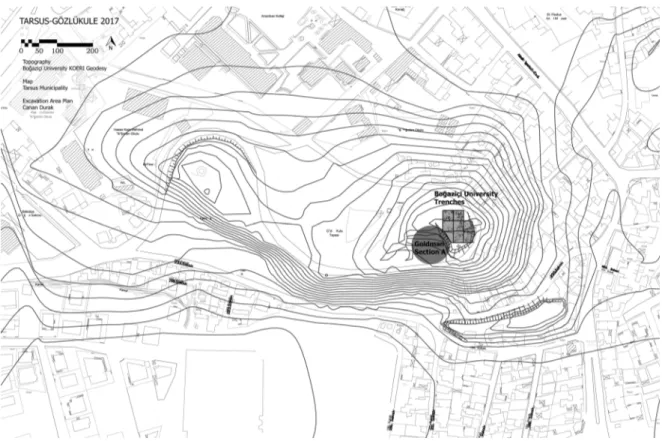
The double-peaked mound of Gözlükule was located on the banks of the Berdan or Tarsus Çayı (gr. Kydnos).
Today the site rises in the southern periphery of modern Tarsus. The occupation levels reach to ca. 37 m above
sea level of which at least 10 m is buried in the alluvial plain. The Goldman team worked in two areas: Section A
located on the highest part of the mound and Section B in the saddle area between the peaks. The new BU excavations are located immediately to the northeast of Section A and take place in an area of approximately
700 m2.
Bibliography
Bağcı 2016; Goldman 1950, 1956a, 1956b, 1963; Karacic 2014; Mellink 1989, 1993; Manning et al. 2016
Mommsen et al. 2011; Mountjoy 2005; Özyar 2005; Özyar et al. 2017; Özyar 2017; Slane 1987; Ünlü 2009, 2011, 2015, 2016a, 2016b; Yalçın 2013
General Periodization
In this chart the Goldman excavation areas are referred to as Section A and B as in her final reports, for details consult the publications.
Period Date10 Tarsus-Gözlükule11
Neolithic 7000–5800 BC Goldman Section A Chalcolithic 5800–?? BC Goldman Section A
EB Ia 3300–2900 BC Goldman Section A
EB Ib 2900–2700 BC Goldman Section A
EB II 2700–2400 BC Goldman Section A
EB IIIa 2400–2200 BC Goldman Section A
EB IIIb 2200–2000 BC Goldman Section A
MB I 2000–1800 BC Goldman Section A
MB II (Goldman LB I) 1800–1600 BC Goldman Section A LB I (Slane A VII–VIII) 1600–1400 BC Goldman Section A
LB IIa 1400–?? BC Goldman Section A Goldman Section B
LB IIb ??–1100 BC Goldman Section A Goldman Section B BU
EIA 1100–850 BC Goldman Section B
MIA 850–700 BC Goldman Section B
LIA a/b 700–520 BC Goldman Section B
Hellenistic 330–50 BC Goldman Section A Goldman Section B
Roman 50 BC–330 AD Goldman Section A Goldman Section B BU
Late Antique 330–637 AD Goldman Section A Goldman Section B BU Early Medieval 637–900AD Goldman Section A Goldman Section B BU Late Medieval 900–1400 AD Goldman Section A Goldman Section B BU
10 Following the middle chronology of Manning et al. (2016): Babylon destruction by Murshili I in 1595 BC.
Stratigraphy and Characteristics
12Neolithic: compares to Yumuktepe Neolithic sequence; presence of obsidian; virgin soil not reached
Chalcolithic: ʿUbaid painted wares; straw wiped (not flint-scraped) Coba bowls; Chalcolithic jar burials (cemetery?)
Early Bronze I: Red Gritty Ware
Early Bronze II: Red Gritty Ware; Wheelmade Light Clay Ware; imports increase; fortification Early Bronze III: West Anatolian drinking set
MB I: Cilician Painted Ware; carinated bowls; eye pitchers
MB II: Later version of Cilician Painted Ware; burnished, carinated bowls with high pedestal foot; burnished, carinated bowls with four handles
LB I: Hittite Monochrome Ware; Black Impressed Ware compares to Atchana IV-V; Kinet level 15 LB IIa: Hittite Monochrome Ware; Red Lustrous Wheel-made Ware
LB IIb: Hittite Monochrome Ware; Late Helladic IIIC Early-Middle-(Late?); BU excavations revealed two phases of occupation consisting of trash pits (with HMW and LHIIIC found together in some) and few walls EIA: Cypro-Cilician Painted Ware; Red Slipped Ware; few Greek imports
MIA: Cypro-Cilician Painted Ware; Red Slipped Ware; more Greek imports
LIA a: Cypro-Cilician Painted Ware declines; abundant Greek imports; few Assyrian imports
LIA b: still Cypro-Cilician Painted Ware; decrease in Cypriot imports; Greek Wares and imitations dominate Persian Period: not attested
Hellenistic: Hellenistic Slipped Wares; Megarian bowls; West Slope Ware
Roman: Eastern sigillata A; Italian sigillata; Lead Glazed Ware; Kapitän 2 amphora; BU excavations uncov-ered remains of several workshops and a votive terracotta deposit containing figurines; masks and lamps in an area terraced into the LB matrix of the mound (trench C7 17)
Late Roman/Byzantine: African Red Slip Ware; Phocean Red Slip Ware; Late Roman D; Sinope Amphora; Late Roman Amphora 1; Late Roman Amphora 4; BU excavations uncovered an occupational phase with remains of architecture in the same orientation as the Early Medieval structures and reused by these.
Early Medieval: Monochrome and polychrome glazed Wares (Samarra horizon); Imported polychrome and
bichrome Luster Wares; Egg-shell Ware; neckless cooking pot (“Brittle Ware”); softstone vessels; the Goldman
excavations uncovered occupational phases of this period in Section A and B, but these levels have not been
published (see Bağcı 2016); BU excavations uncovered several phases of occupation with one main
architec-tural level (see Özyar et al. 2017).
Late Medieval: Fritwares; Sgraffito Wares; Port Saint Simeon Ware; BU excavations attested few remains of this phase consisting of a small paved area and drainage.
Adana Tepeba
ğ (Fig. 5)
Fatma Şahin (Çukurova University Adana)
Short Excavation History
Tepebağ Höyük was entered in the official register in 1967, and excavations here were then carried out at
irregular intervals by the Adana Archaeological Museum. Since these excavations reached a limited depth only, they provided no information about the stratigraphy of the mound for its earlier periods.
12 References to characteristic pottery of the Hellenistic, Roman, Late Roman/Byzantine, Early and Late Medieval Periods were kindly provided by Agnès Vokaer.
The present excavations including the first steps to realize an archaeopark project were conducted
between the years 2013–2016 under the directorate of the Adana Archaeological Museum and scientific
advisory of the members of the Archaeology Department of Çukurova University, headed by the present author.
Fig. 5: Adana-Tepebağ. Topographic plan.
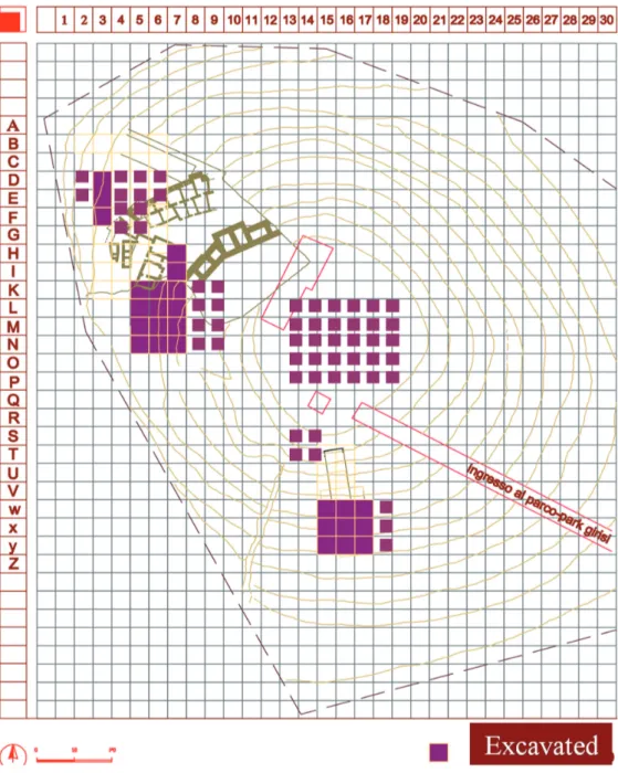
Topography and Excavation Areas
Tepebağ Höyük is a settlement mound, which is today located in the city centre of modern Adana, in the
Tepebağ and, partly, Kayalıbağ districts. It is limited to the east by the Seyhan river and measures ca. 620 m
north-south and 360 m east-west. The entire Roman city including the lower settlement was spread out over
an area of about 20 hectares. The mound itself rises about 15 m high from the plain level.
The top of the mound is occupied by registered historical old town buildings and modest present-day
dwelling houses dating back to the 18th century. At the top of the mound, an area measuring 70×80 m was
cleared from modern occupation to allow excavations. The registered historical buildings in this area are preserved and protected by the General Directorate of Cultural Assets and Museums (Ministry of Culture and Tourism).
So far, soundings have been made in 15 different trenches, each measuring 10×10 m. These trenches are situated on the summit of the mound and were opened in order to establish a proper stratigraphy throughout
the site history. In two of these trenches levels at a depth of 4.5 m below the surface were reached, dating to
the second millennium BC, in other words, to the Late Bronze Age. At the end of the work, reliable evaluation of the archaeological material could be made according to the established stratigraphy in spite of huge
destructions. Thus, it is understood that the mound was occupied uninterruptedly at least from the Late Bronze Age up to the present day.
Bibliography
Şahin 2016a, 2016b, 2017.
General Periodization
Conventional Period Period
Late Bronze Age PeriodVI
Iron Age PeriodV
Classical Period PeriodIV
Roman and Byzantine Period PeriodIII Medieval and Ottoman Period PeriodII Early periods of Turkish Republic Era PeriodI
Stratigraphy and Characteristics
Period I: Early periods of Turkish Republic Era, Level 1
Heavy damage affected the surface of the mound due to modern urban infrastructure. Among the finds discovered in this level we can cite ethnographical material such as pottery, a metal bowl used in a Turkish bath, a thimble, a samovar and a pipe.
Period II: Ottoman-Mediaeval Period, Level 2–3
This period with two levels corresponds to the late and early phases of the Ottoman Period. Various architectural remains belonging to the first level were uncovered and its settlement plan began to emerge. In the lower level, architecture was not well preserved due to various destructions. Terracotta vessels, stamp seals, coins, pipes, and lamps have been recovered.
Period III: Byzantine-Roman Period, Level 4
The architectural remains of this period were severely damaged by wells and pits of upper levels. The Roman settlement was concentrated along the Seyhan river. Pottery like terra sigillata as well as various weights and lamps come from this level.
Period IV: Classical Period, Level 5–6
Level 5 is dated to the Hellenistic period. The architecture, which is heavily damaged by later wells and pits,
consists of wall remains without recognisable plan and pebble flooring. Among the pottery forms of this
period, dated to 3rd–1stcenturies BC, are Megarian bowls and skyphoi. Level 6, dated to the 6th–4thcenturies
Period V: Iron Age, Level 7–9
An Iron Age level with two architectural phases was reached at a depth of about 4 m below the surface. Two
different structures separated by a 3 m-wide street were exposed. Late, Middle and Early Iron Ages could be
detected stratigraphically. The light-on-red or brown-painted pottery is typical for the Early Iron Age. Painted motifs during this time are geometrical and mostly include bands, cross-hatching and circles. This pottery continues to be seen together with dark grey and black-painted pottery in the succeeding Middle Iron Age. The Late Iron Age, on the other hand, yielded Cypriot imports and East Greek pottery alongside the painted grey pottery.
Period VI: Late Bronze Age, Level 10
A Late Bronze Age deposit was reached under the Iron Age architecture. However, it was not possible to determine how many phases the Late Bronze Age contained, due to insufficient time. Typical pottery of the
Hittite Empire was recovered, however no architecture was encountered in this level. Among these,“drab
ware”, which is of utmost importance for dating, is well represented. Cypriot White Slip II/Milk Bowl
fragments were also found.
Misis Höyük (Fig. 6)
Anna Lucia D’Agata (Consiglio Nazionale delle Ricerche, Roma)
Short Excavation History
With its höyük located along the lower course of the Ceyhan, Misis is one of the few urban centres on the southern route that in antiquity linked the Anatolian plateau to the Levant and the Near East, and controlled
access to the Mediterranean ports. The höyük reaches 56.63 m above sea level on the western side, where the
acropolis of the Roman city was located. The excavated area, currently covering about 2500 m2, comprises the
summit of the höyük and its south-western slopes. The importance of the site of Misis and its archaeological potential were understood by Veronica Seton-Williams during her Cilician survey (1954: 154). The soundings opened a few years later by Helmuth Bossert on the summit of the höyük brought to light remains of walls
dating from the early 1920s to Late Antiquity (our Phases 1–6). The Misis Höyük Archaeological Project, which
was launched in 2012, is a multidisciplinary research carried out in collaboration between the CNR (Rome), the University of Pisa, the Ministry of Culture and Tourism of the Republic of Turkey, and the Municipality of
Yüreğir. It was preceded by an archaeological survey undertaken in the area of the lower course of the Ceyhan
(Salmeri/D’Agata 2011; Isola et al. 2017). Among other things, this survey determined that in antiquity Misis
was the central place in the area between the Misis Dağ to the east and the Ceyhan river basin to the west.
Topography and Excavation Areas
To date, our excavation on the south-western side of the höyük has made it possible to distinguish 14 archi-tectural phases, the majority of which correspond to diverse political entities succeeding one another at the site. Phase 13, the earliest hitherto clarified (phase 14 is still being excavated), dates to the Middle Iron Age, a period that, with its long stratigraphic sequence, is one of the most important at the site and seems to mark the rise of the Syro-Anatolian city. As concerns the prehistoric settlement, layers of the late phases of the Neolithic, and of the Chalcolithic periods have been identified in a section exposed on the north-western slopes of
Fig. 6: Misis. Schematic plan of the excavated area, indicating occupational phases, and its localization on a general map of the ancient town (topographic survey and digital drawing by G. Luglio).
at the time ran around the hill to the west. Furthermore, the large quantity of materials from the Middle Bronze Age collected on the höyük in later layers suggests that in the first half of the second millennium BC the site was densely settled. Aside from the archaeological evidence, the long-term history of Misis is also documented
MISIS HÖYÜK 2017 - Phase4 - Phase 5-6 - Phase7-8 Phase 10 - Phase 11 - Phase 13
by the town’s name changes, especially from the Hellenistic period onwards. Each of these names may represent a true refoundation, reflecting the establishment of a new political system.
The names of Misis in the past were:
Paḫri (?) 10th
–8thcenturies BC
Mopsouestia Seleucia ad Pyramum
3rdcentury BC–7thcentury AD
for a few years in the first half of the 2ndcentury BC
al-Massisa 8th–10thcenturies AD
Mamistra 11th
–14thcenturies AD
Misis Modern Times
Bibliography
Bossert 1957; Budde 1969; D’Agata 2017; Isola et al. 2017; Salmeri 2004; Salmeri/D’Agata 2011; Salmeri et al.
forthcoming; Seton-Williams 1954.
General Periodization
Conventional Period
Dates Misis Höyük
Phase
Misis Höyük Greece Cyprus
Iron Age IB 14 Urban occupation
(excavation in progress) Iron Age IIA 950–850? BC 13 Urban occupation, silos for
storage; industrial structures
Euboean Late Proto-Geometric/ Sub-Protogeo-metric Cypro-Geometric II–III
Iron Age IIB 850–760/750 BC 12 Urban occupation, installation for decanting liquids Euboean Sub-Protogeometric III/ Attic Middle Geometric I–II/ Late Geometric I Cypro-Geometric III 11.1–3 Urban occupation, terraced building Iron Age IIB 760/750–720/700 BC 10 Urban occupation,
fortified building Late Geometric II–III Cypro-Archaic I Hellenistic 4th –2ndcenturies BC 9 ? Roman 1stcentury BC – 3rdcentury AD 7–8 Sanctuary (Temple of Aphrodite-Isis?), industrial structures Late Roman 4th–7thcenturies 5–6 Christian monumental
complex (basilica, cisterns) Early Islamic 8th–9thcenturies 4 Urban occupation,
fortified building Medieval 12th–14thcenturies 3 Fortified area,
industrial structures French Mandate 1919–1922 2 Military garrison Turkish Republic 1970 (?)–2014 1 Military garrison
Stratigraphy and Characteristics
Misis Höyük Phase 3: Glazed pottery and polychrome sgraffito ware, also figured, are common. Large storage jars, clay kiln trivets and unfinished (biscuit-fired) pottery are present.
Misis Höyük Phase 4: Rich ceramic assemblages, with pottery of Abbasid type, in particular fine buff wares with moulded decoration (mostly jugs), and cooking pots (brittle ware, cylindrical vessels with dark fabric, and horizontal lug handles). Glass vessels are common.
Misis Höyük Phase 5–6: These phases are mostly represented by huge, ashlar foundation walls that have largely destroyed the earlier stratigraphy. Few soil deposits have been excavated, which include Late Roman pottery.
Misis Höyük Phase 7–8: Glazed red slip pottery (Eastern Sigillata A, Sigillata) is ubiquitous. There are also large quantities of terracotta figurines, clay lamps and bone tools (needles, mainly).
Misis Höyük Phases 10–12: Rich Cypro-Cilician ceramic repertoire, with distinctive cooking ware and handmade jars (Iron Age II). Greek Geometric and Cypriot imports are present.
Misis Höyük Phase 13: Cypro-Cilician ceramic wares, with shapes and characteristics of early type (Iron
Age II). Greek and Cypriot imports are present.
Sirkeli Höyük (Fig. 7)
Mirko Novák (Bern University), Ekin Kozal (Çanakkale University), Sabina Kulemann-Ossen (Bern University), Deniz Yaşin Meier (Bern University)
Short Excavation History
Sirkeli Höyük is situated 40 km east of Adana at the left bank of the Ceyhan river, precisely at the point where
the river finds its passage through the Misis Mountains. During the winter of 1936–1937 John Garstang directed
the first excavations in Sirkeli Höyük. On this occasion, the rock relief showing Hittite King Muwattalli II was discovered. After Garstang decided to focus on Mersin-Yumuktepe, the site was not investigated for 55 years except for the visit of Veronica Seton-Williams in the context of her survey. In 1992 Barthel Hrouda resumed excavations, continued annually until 1996, and was followed by one campaign in 1997 under the supervision of his former architect Horst Ehringhaus. In 2006, the project was re-started under the direction of Mirko Novák and Ekin Kozal as a cooperation of the universities of Tübingen and Çanakkale. In 2011 the project was
transferred to Bern University, and since 2014 Deniz Yaşin Meier has replaced Ekin Kozal as co-director.
Topography and Excavation Areas
The settlement comprises the mound proper of 8 ha, a south-eastern and southern lower town of an additional 12 ha at minimum, extramural workshop areas to its north and east, and a necropolis on a natural hill located to the southwest of the mound. Furthermore, a suburb is attested on the opposite side of the river to the north.
The mound itself thus formed only the citadel of the ancient settlement. It rises to a height of almost 40 m and
was subdivided by a step in elevation into a lower northern“outer” plateau and a higher southern “inner”
citadel. Excavations of Garstang, Hrouda and Ehringhaus focused exclusively on the citadel mound. The lower town has only been discovered by geophysical prospections and surface surveys undertaken since 2007. Since then, one major trench has been opened in the south-eastern (Sector F), and a minor one in the northern (Sector B) lower town. Other recent excavations are located in the north-western (Sector A) and
central (Sector C) parts of the plateau and on the summit of the inner citadel mound (Sector D).
Bibliography
Ahrens et al. 2010; Ehringhaus 1999; Hrouda 1997; Kozal/Novák 2013 and 2017; Novák et al. in press.
General Periodization
Stratigraphy is counted separately in each Sector, giving the Sector key (A, D, F etc.) and the local phase in Arabic numbers (A09, F15 etc.). Within each area of the site a comparative stratigraphy of all sectors leads to an architectural periodization, given in Roman numbers. To distinguish the stratigraphies of each area a
marker is added for Lower Town (“U”), Plateau (“P”) and inner Citadel (“Z”). In this way, three different
stratigraphies exist in Sirkeli for the three parts of the settlement.
On the basis of the characteristics of the architecture and the artefacts an overall periodization is defined. To avoid any misinterpretation or misunderstanding, these periods are not named after the commonly used Metal Age terminology but instead according to a neutral regional periodization adopted and developed from
the“Associated Regional Chronologies for the Ancient Near East and the Eastern Mediterranean (ARCANE)”
project, which successfully challenged the conventional third millennium BCE chronologies.13 The new
regional terminology for Cilicia used in Sirkeli introduces Early, Old, Middle and Neo-Cilician Periods, abbreviated as ECI, OCI, MCI, and NCI, respectively, after the ARCANE system. LCI means Late Cilician Period, dating from 330 BCE until AD 636.
Conventional Periodization (approximate correlation) Approximate Date14 New Cilician Periodization
Early Bronze Age I–IV 2900–2050 ECI
Middle Bronze Age I
(corresponds to Ur III/Isin-Larsa and Alişar III/Kārum-Period)
2050–1950 OCI 1
1950–1700 OCI 2
Middle Bronze Age II
(corresponds to Babylon I and Hittite Old Kingdom)
1700–1560 OCI 3
1560–1522 MCI 1
Late Bronze Age I (Kizzuwatna)
Successive Mittanni and Hittite Dominance
After 1522–1420 MCI 2
1420–1400 MCI 3a
1400–1350 MCI 3b
Late Bronze Age II Part of Hittite Empire
1350–1190 MCI 4
Iron Age I 1190–1130 NCI 1
1130–950 NCI 2
Iron Age II 950–720 NCI 3
720–609 NCI 4
Iron Age III 609–539 NCI 5
539–330 NCI 6
Stratigraphy and Characteristics
Period Citadel (Z) Plateau (P) Lower Town (U)
ECI 5 Z XI
Domestic architecture
Sherds Attested in survey:
Northern Lower Town
OCI 1 Z X
Dense occupation, domestic architecture
Sherds Attested in survey:
Northern, Southern and Southeastern Lower Towns
OCI 2 P VII
Mud brick architecture OCI 3
MCI 1 Z IX P VI
Stone building A1
Attested in survey: Northern Lower Town
MCI 2 ? MCI 3 Z VIII MCI 4 Z VII Stone Building D1 Attested by sherds NCI 1 U V
Foundation of City Wall
NCI 2 Z VI
Foundation of Citadel Wall (?) P V
Modification and reuse of Stone Building A1
NCI 3 Z V
Reuse of Building D1
U IV
Early phase of City Wall
NCI 4 Ceramic trash layer with
Assyrian pottery
P IV
Domestic architecture
U III
Later modification of City Wall
NCI 5 Z IV
Domestic architecture
P III
Domestic architecture
U II
Latest use and abandonment of City Wall
NCI 6
LCI 1 Z III
No architectural remains
P II
Two phases of domestic architecture, monumental building in Sector C
Abandonment of Lower Town
Z II
Stone robbery trenches
Sherds in Lower Town
Recent Z I P I U I
LC/ECI 5: Late Chalcolithic Pottery derives mainly from Hrouda’s excavations on the citadel mound
(“Areal” 3) and from the survey. It is represented by“Chaff-Faced” and “Coarse” Wares. ECI pottery includes
“Brittle Orange Ware”.
OCI: Painted “Syro-Cilician Ware” predominates, along with plain wares, red slipped and brown slipped wares.
MCI is characterized by Hittite (Central Anatolian) pottery, which replaces the Syro-Cilician repertoire
comple-tely. Standard Ware is very common, whereas some pieces belong to the“Drab Ware” type. Cypriot imports
include Bichrome, Red-on-Black, Monochrome, Base Ring I and White Slip II Wares. Red Lustrous Wheel-made Ware (RL) is also present.
NCI 1 is an intermediate phase still characterized by Central Anatolian ceramic tradition but with the appearance of a few Late Helladic IIIC-sherds.
NCI 2 shows the return of a painted pottery tradition (early types of Cypro-Cilician pottery) including the
so-called“kindergarten-ware”.
NCI 3 is the period of the distinctive painted “Cypro-Cilician” pottery, including all wares of the so-called “Cypro-Geometric” repertoire, but surely locally produced.
NCI 4 is characterized by the strong presence of Neo-Assyrian pottery, dating to the end of the 8th until
mid/late 7th c. BC. A few hybrid examples show paintings of“Cypro-Cilician” style on Assyrian forms. Some
Aegean imports occur.
NCI 5 and 6 show some forms reminiscent of “post-Assyrian” assemblages from Syro-Mesopotamia.
Radiocarbon analyses– most deriving from charcoal samples – were done by Sönke Szidat (Bern University)
giving the following results:
Period Historical dating BCE
Sample Phase Code LARA uncalibrated.
14C-date (before 1950) calibrated (BCE) MCI 1–2 1560–1350 MCI 3–4 1350–1190 Si16-D0336 SE-D0281 Z VIII BE-6014.1.1 3343±20 1689–1536 Si16-A0039 SE-A0500 P VI (?) BE-6020.1.1 3338±20 1687–1536 Si16-A0054 SE-A0508 P VI BE-6022.1.1 3223±20 1528–1439 Si13-D0182 SE-D0204 Z VIII BE-6005.1.1 3191±20 1501–1427 NCI 1 1190–1130 Si15-A0137 SE-A0479 P V BE-6018.1.1 2964±19 1258–1117 Si16-D0382 SE-D0399 Z VII BE-6011.1.1 2929±20 1209–1053 Si15-A0153 SE-A0479 P V BE-6019.1.1 2916±20 1206–1025 NCI 2 1130–950 Si16-D0324 SE-D0340 Z VI BE-6012.1.1 2934±20 1210–1055 Si15-D0276 SE-D0287 Z VI BE-6010.1.1 2929±20 1209–1053 Si15-D0287 SE-D0287 Z VI BE-6009.1.1 2917±20 1206–1028 Si13-A0096 SE-A0460 P V BE-6016.1.1 2903±20 1191–1013 Si16-D0274 SE-D0372 Z VI BE-6015.1.1 2901±20 1191–1011
Period Historical dating BCE
Sample Phase Code LARA uncalibrated.
14C-date (before 1950) calibrated (BCE) Si15-D0196 SE-D0261 Z VI BE-6007.1.1 2897±20 1189–1009 Si15-D0222 SE-D0268 Z VI BE-6008.1.1 2873±20 1116–980 Si16-D0345 SE-D0396 Z VI BE-6170.1.1 2855±20 1108–936 NCI 3 950–720 Si16-D0325 SE-D0136 Z V BE-6013.1.1 2875±33 1190–932 Si13-D0172 SE-D0198 Z V BE-6006.1.1 2880±20 1123–998 Si15-F0186 SE-F0204 U III BE-6024.1.1 2844±20 1081–924 Si16-F0260 SE-F0293 U IV BE-6030.1.1 2758±43 1002–820 Si16-F0288 SE-F0302 U III BE-6032.1.1 2775±20 992–846 Si16-F0242 SE-F0278 U IV BE-6029.1.1 2774±20 991–845 Si16-F0272 SE-F0295 U IV BE-6031.1.2 2756±20 970–836 Si16-F0192 SE-F0279 U IV BE-6027.1.1 2743±20 924–832 Si15-F0204 SE-F0210 U IV BE-6025.1.1 2739±20 920–831 NCI 4 720–609 Si16-F0176 SE-F0269 U III BE-6026.1.1 2763±20 973–838 Si16-F0202 SE-F0269 U III BE-6028.1.1 2717±34 922–808
Tatarl
ı Höyük (Fig. 8)
K. Serdar Girginer, Özlem Oyman-Girginer (Çukurova University, Adana)
Short Excavation History
The mound was discovered by M.V. Seton-Williams in 1951. After Mustafa H. Sayar’s visit in 1991, the
Kizzuwatna Research Project was initiated by K. Serdar Girginer in 2005. Systematic excavations began in
2007 under the directorship of K. Serdar Girginer, on behalf of the Ministry of Culture and Tourism and
Çukurova University, the Metropolitan Municipality of Adana, and the Adana Chamber of Commerce.
Topography and Excavation Areas
About 85 km east of Adana, Tatarlı Höyük is located within the county of Ceyhan. It is one of the largest
settlements in the fertile plain of Eastern Cilicia, situated on the Hasanbeyli-Fevzipaşa road close to the Beilan
Fig. 8: Tatarlı Höyük. Topographic plan (© Tatarlı Höyük Project).
strategic location, the settlement is situated inside the largest natural water basin of East Çukurova within a basaltic environment. As a result, seven springs can today be detected in the area of the ancient settlement
and its immediate vicinity. Moreover, the conjunction of the Beynamazı and Mercin streams is located inside
the perimeter of the site. Basaltic formations have also provided stone resources for the settlement. Thus, the architecture of the mound consists largely of basalt.
The mound measures ca. 230×370 m, and was surrounded by an extensive lower town of at least eight
times the size of the mound. Hence, it was one of the largest cities of ancient Kizzuwatna in the second
millennium BC.
Work in Tatarlı Höyük has concentrated on several sectors. In the East has been exposed Building A, dating to the Late Bronze Age I and II and to be identified as a temple. In the western part, a fortification
system has been excavated, dating to the Late Bronze Age–Middle Iron Age. On the northern slope, a step
trench was opened to reveal the stratigraphical sequence. In the Northeast, a gateway to the citadel and a paved sloping road were exposed.
Bibliography
Girginer 2007; Girginer 2008a; Girginer/Uygur 2014; Ünal/Girginer 2007; Girginer et al. 2017; Girginer/Collon 2014; Ünal/Girginer 2010; Kavak et al. 2017; Girginer et al. 2016; Girginer et al. 2015; Sayar et al. 1993; Girginer
General Periodization
Classical Period Period
Neolithic (pre-Ḥalaf) Late Neolithic (Ḥalaf)
Tatarlı VIII b Tatarlı VIII a Early and Middle Chalcolithic (LateʿUbaid)
Late Chalcolithic
Tatarlı VII
Early Bronze Age III (?) Tatarlı VI
Middle Bronze Age Tatarlı V
Late Bronze Age I Tatarlı IV b
Late Bronze Age II Tatarlı IV a
Early Iron Age ? –
Middle Iron Age (Late Assyrian ?) (Neo Hittite)
Tatarlı III b 1
Late Iron Age (Achaemenid) Tatarlı III a Hellenistic/Early Roman Tatarlı II a–b Early Byzantine Necropolis (Citadel Eastern Slope) Tatarlı I
Stratigraphy and Characteristics
Tatarlı Höyük I: The surface level of the mound is defined by tombs lined with roof tiles, which may belong to three phases of the Early Byzantine period. The tombs were exposed on the eastern slope.
Tatarlı Höyük Level IIa–b: Eastern Sigillata A, West Slope ceramics, Megarian bowls, fish plates, inward-rimmed bowls, coins and terracotta figurines characterize the material of this phase.
Tatarlı Höyük Level IIIa: An Achaemenid stela and plain pottery of the Late Iron Age were discovered. Tatarlı Höyük Level IIIb: Finds include a kohl box, and pottery of Black-on-Red, White Painted and Bichrome Ware types.
Tatarlı Höyük Level IVa: Finds include Hieroglyphic bullae, seals, long-necked bottles, votive vessels, miniature bowls, and Hittite monochrome ware.
Tatarlı Höyük Level IVb: Finds include Hittite monochrome wares, hieroglyphic and uninscribed bullae. Tatarlı Höyük Level V: Finds include Syro-Cilician painted pottery, Cypriot White Painted Pendant Line Style, cylinder seals, figurines, bull rhyta and ring-shaped vessels, bird-shaped vessels.
Tatarlı Höyük Level VI: Pottery is characterized by Orange Ware (similar to Tilmen and Gedikli Höyük). Tatarlı Höyük Level VII: Pottery shows Mesopotamian and Syrian influence; Amuq F-related stamp seals. Tatarlı Höyük Level VIIIa: Finds include a Halafian stamp seal.
Tatarlı Höyük Level VIIIb: Finds, including a stamp seal, are related to Northern Syria, Raʾs Šamra, and Tall
al-Karḫ 2.
Period Date Level Historical affiliation Features and objects Connections Early PN Late PN (Ḥalaf) 7000–6300 6300–5000 VIIIb VIIIa Stamp seals Stamp seals Northern Levant (Raʾs Šamra,
Tall al-Karḫ 2, Tell Açcana, Kazane, Tepecik-Çiftlik, Yumuktepe, Yarım Tepe I and Cilician settlements EC (ʿUbaid)
LC
5000–4000 4000–3000
VII Amuq F-related stamp seals Mesopotamia,
Syria, Amuq
Period Date Level Historical affiliation Features and objects Connections MBA 2000–1650 V kārum-Period Painted Syro-Cilician pottery,
Cypriote WPPLS, cylinder seals, figurines, ring-shapes vessels, bull rhyta and bird-shaped vessels
Northern Levant, Cyprus, Central Anatolia
LBA I 1650–1450 IV b Kizzuwatna
Hittite Old and Middle Kingdoms
Hittite monochrome wares, hieroglyphic/non-hiero-glyphic bullae
Central Anatolia
LBA II 1450–1200 IV a Kizzuwatna Hittite Province
Hieroglyphic bulla, seals, long-necked bottles, votive vessels, miniature bowls, Hittite monochrome ware, drab ware
Central Anatolia, Cyprus, Northern Levant Early IA 1200–850 – Middle IA (Neo-Hittite, Late Assyrian) 850–609 III b1 Hiyawa/Que Assyrian Domination
Kohl box, Cypro-Cilician painted pottery
Late IA 539–330 III a Achaemenid Stela and pottery
Hellenistic/ Early Roman
330–50 BC II a–b Eastern Sigillata A, West Slope ceramics, Megarian bowls, fish plates, incurved-rim bowls, coins and terracotta figurines Early Byzantine 4thcentury AD
and later
I Necropolis on eastern slope
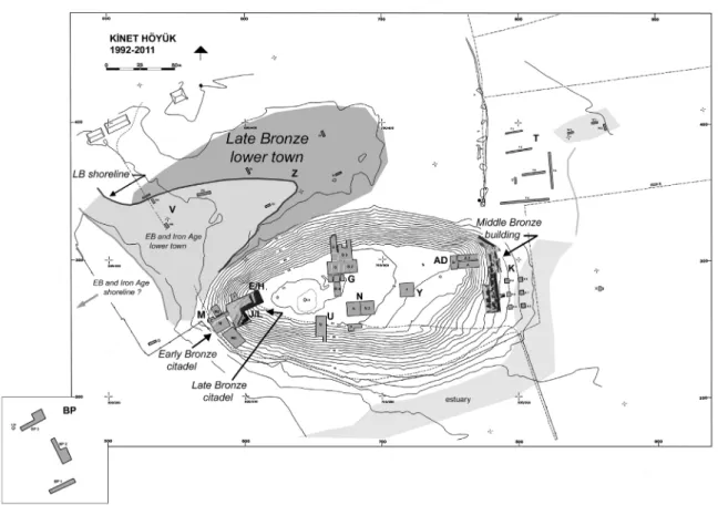
Kinet Höyük (Fig. 9)
Christine Eslick (Sydney), Charles Gates (Bilkent University), Marie-Henriette Gates (Bilkent University), Gunnar Lehmann (Ben-Gurion University of the Negev)
Short Excavation History
Kinet Höyük is located on the modern seashore at the back (north end) of Iskenderun Bay (İskenderun
Körfezi), ca. 35 km north of Iskenderun. Excavations were conducted on the mound and its immediate
periphery by a Bilkent University (Ankara) project from 1992–2012, directed by M.-H. Gates. Additional
soundings were led by A. A. Eger in 2006, 2008 and 2011 at a medieval settlement (“Tüpraş Field Site”) 800 m
north of Kinet; and in 2004 by B. Claasz Coockson at a Late Antique bridge at Kırıkköprü Mevkii, ca. 1.75 km
south of Kinet. In collaboration with the Kinet project, A. Killebrew and her colleagues’ “Mopsos Survey
Project” recorded and mapped 195 ancient sites in Iskenderun Bay’s eastern coastal plain, from Erzin to Arsuz,
in 2004–2009.
Topography and Excavation Areas
Kinet Höyük is a steep, triangular mound, 3.3 ha in area and 26 m high, set on the north bank of an ancient
estuary and pointing towards the sea. Trenches (“operations”, abbreviated OP) were opened on the mound’s
top (areas G, N, P, Y); on its east, north, west and south slopes (areas A/D, G, J/L-E/H-F-C, M and U); and on the low east terrace (K). Soundings to determine the presence of a lower town were opened in fields to the
Fig. 9: Kinet Höyük. Topographic plan (© Kinet Höyük Project).
mound’s east (X), north (areas R, S, T, V, W, Z) and on BP-Dörtyol terminal property between the mound and
the sea (“BP trenches”).
Bibliography
Gates, C. 2015; Gates, M.-H. 2000, 2006, 2011; Gates et al. 2015; Lehmann 2016, 2017; Redford et al. 2001.
General Periodization
Archaeological Period Date Kinet Phase Kinet Period
EB I and earlier periods, includingLate Neolithic/Ḥalaf
5500–2900 BC [not excavated: finds out of context]
———————————————— Early Bronze II
*not excavated to base of EB II
2900–2600 BC VI.4 29–25
Early Bronze III 2600–2420 BC VI.3 24
Early Bronze III 2420–2250 BC VI.2 23–22
Early Bronze III 2250–2050 BC VI.1 21–19
Middle Bronze I 2000/1900–1750 BC V.2 18
Middle Bronze II 1750–1550 V.1 17–16
Late Bronze I
(= end of Hittite Old Kingdom)
Archaeological Period Date Kinet Phase Kinet Period Late Bronze II
(= Hittite Empire)
1400–1200 BC IV.1.1 14–13.1
Late Bronze III (Sub-Hittite)
1200–1150/1130 BC IV.1.2 13.2
Early Iron Age 1150/1130–900 BC III.3 12–(?)11
Middle Iron Age
(Kinet Period 8:Neo-Assyrian)
900–650 BC III.2 11 (?)
10 9
8 Neo-Assyrian Late Iron Age
(Kinet Period 5–3B: Persian)
650–330/300 BC III.1 7–6
5 Persian 4 Persian 3B Persian
Hellenistic 330/300–90/75 BC II 3A–2
Medieval 8th/9thc.–14thc. AD I 1 + Tüpraş Field site
Stratigraphy and Characteristics
Kinet Höyük Phase VI.4: Early Bronze Age II, Periods 29–25
Periods 29–25: Buildings have mud brick walls without stone base. Local pottery in four fabrics is both
wheelmade (Standard Ware cups and bowls); and handmade (Standard Ware pitchers and jars; Gritty
Red vessels; chaffy Red Burnished vessels). Ceramic types relate to theİslahiye region, and Amuq H. A few
imported Red-Black Burnished Ware sherds occur in all phases.
Kinet Höyük Phase VI.3: Early Bronze Age III
Period 24: Buildings have stone foundations sunk in trenches. Pottery is now mostly in Standard fabric, both wheelmade and handmade. Types include conical cups, tankards, flaring plates, pitchers with low-beaked spouts, and smeared wash finishes. This ceramic tradition continues through Period 19, with new types introduced in each period.
Kinet Höyük Phase VI.2: Early Bronze Age III, Periods 23–22; Period 23 suffers several earthquakes.
Periods 23–22: Buildings have stone socles of two or three courses set on level ground. New pottery types are
deep one-handled cups and Syrian bottles. Finds include a cache of tin bronze pins and tools.
Kinet Höyük Phase VI.1: Early Bronze Age III, Periods 21–19; Period 19 ends in abandonment, followed by a
gap in occupation.
Periods 21–19: Buildings now have stone walling up to ca. 1 m high. New pottery types are goblets, depata of
Kinet Höyük Phase V.2: Middle Bronze Age I, Period 18; ends in destruction.
Period 18: The pottery is wheelmade (tablewares) and coilmade. It includes early versions of Cilician Painted
(“Syro-Cilician”) Ware, like MB I Tarsus and Alalaḫ “XVIII”–X.
Kinet Höyük Phase V.1: Middle Bronze Age II, Periods 17, 16; both end in destructions (earthquakes).
Period 17: The later version of Cilician Painted Ware appears in this level; the pottery assemblage is in most aspects similar to Period 16. This level is attested from small soundings only.
Period 16: The ceramic assemblage is similar to Period 17’s, but introduces MB II transport jars
(“Canaan-ite jars”), and MCIII-LC I Cypriot imports, including Bichrome Ware.
Kinet Höyük Phase IV.2: Late Bronze Age I, Period 15; ends in abandonment, followed by erosion.
Period 15: In this phase with large-scale architecture, a Hittite/Central Anatolian ceramic industry replaces the Syro-Cilician repertoire completely. This period includes Cypriot imports of LC I date, such as Bichrome Ware; early LC II (Base Ring I, White Slip I), and Red Lustrous Wheel Made Ware (RLWMW).
Kinet Höyük Phase IV.1.1: Late Bronze Age II, Periods 14 and 13.1; both end in destructions.
Periods 14–13.1: Hittite ceramic types adopt the uniform, mass-produced repertoire (“drab ware”) of the Hittite
empire. Deposits include LB Canaanite jars with stamped handles, LC II imports and RLWMW.
Kinet Höyük Phase IV.1.2: Late Bronze Age III, Period 13.2; ends in destruction (earthquake).
Period 13.2: Ceramic production declines in standard although still deriving from a Hittite tradition. The
industry can be characterized as sub-Hittite. The assemblage includes bowls locally adapted from LH IIIC (or Sub-Mycenaean/Cilicio-Helladic, etc.) styles, dated in Palestine by Dyn. XX-related contexts into the later
12thc. BC.
Kinet Höyük Phase III.3: Early Iron Age, Period 12; ends in abandonment and erosion.
Period 12: This long depositional phase is non-architectural, consisting of thick trash tips and pits that include
local variants of LH IIIC, as well as Cypro-Geometric I/II and other 11thc. ceramic material.
Kinet Höyük Phase III.2: Middle Iron Age, Periods 11–8; Periods 9 and 8 end in destructions.
Periods 11–10: These levels are attested by two poorly preserved architectural phases in a limited exposure on
the west slope. Period 11 includes Cypro-Geometric II–III vessels. Cypro-Geometric III imports in Period 10
span the 9thand perhaps early 8thc. BC; this ceramic style was also imitated locally.
Period 9: Monumental architecture is associated with 8th c. BC Cypro-Cilician pottery, and this level’s
destruction with the campaigns of Tukultī-apil-Ešarra (Tiglath-Pileser) III (730s) or Šarru-ukīn (Sargon) II (710s). Imports include Euboean Pendant Semi-Circle (PSC) skyphoi.
Period 8: Replacement of local features by Neo-Assyrian material culture (ceramics, cylinder seals) and different building standards; they disappear with the destruction of this occupational level.