USE OF LASER SCANNING FOR CULTURAL HERITAGE DOCUMENTATION
Gülhan BENLİ
Assis. Prof., Istanbul Aydin University, Faculty of Engineering and Architecture, Florya Campus,Istanbul, Turkey
e-mail: [email protected]
Abstract: In terms of raising an awareness of the historical, national and cultural properties in our country and ensuring a transfer of information to posterity, it is of vital importance to take inventory of the cultural and natural real properties located in protected sites.
Many fields, such as medical science, construction, ground engineering, geodetic engineering, and architecture, make use of the present-day laser scanning technology. Even if contemporary and current scientific methods are used for the inventory and documentation studies related to cultural and natural real properties in the PROTECTED SITES in the field of architecture; acquiring data of the entirety of a protected site using these methods is a time consuming process. Among the scientific methods applied, laser scanning technology has the utmost importance in the latest years.
The laser scanning devices for the detection of cultural, natural and historical properties in archeological, historical, urban or mixed protected sites in Turkey, eliminate challenges such as the enormity of sites, the difficulty of working in the sites, intense work hours, and the necessity of having a thorough knowledge of the site.
In the scope of this study, the usage, application, facilities, advantages and attainments of geodetic laser scanning systems in conducting surveys on facade, street or avenue silhouettes in the protected sites, where historical buildings within field of architecture are widespread, will be examined.
Keywords: Laser scanning, survey, cultural heritage
1. INTRODUCTION
With the effect of the technological and scientific progress changing in the world, laser scanning systems used in surveying historical buildings have been frequently preferred in the latest years, due to their fast, accurate and intense data production.
For many years, geodetic photogrammetric method and technologies are successfully being used for the documentation studies of cultural properties. The developments in the computer and communications technologies after the 1980s have been used in the geodetic photogrammetric studies and enabled the production of 3-dimensional digital orthoimages and digital surface models using the data acquired in the field. This process brought along the usage of a new technology in documentation works. This technology, known as Geodetic Laser Scanner, enables production of a highly intensive 3-dimensional point cloud data with high accuracy on the surface of an object. From the 3-dimensional point cloud data provided by these technologies, using appropriate software, 3-dimensional surveying–drawing–
modeling can be produced. Consequently, it is possible to talk about 3-dimensional accurate digital documentations which has an accuracy at the level of millimeters and surveying– restoration studies have taken on new and different dimensions.
2. THE USE OF LASER SCANNING TECHNOLOGY IN SURVEYING
Today several methods are being used for the documentation, quantification and surveying of cultural and architecture heritage. These methods may be listed as; surveys using conventional instruments, topographic and photogrammetric surveys, surveys using laser scanning. The documentation in the surveying studies of either a single structure, or an architectural heritage in the scale of a whole area, using digital imaging or 3-dimensional laser scanning devices is a technique which is applied in the latest years. The beam sent from the laser scanning device, to the object or surface across, returns as millions of point data in the computer environment and can be seen as an object formed by the point cloud in digital media. This object or surface is now coordinated according to its ground level, in its actual size and in high accuracy. The object or the surface can be defined in millions of 3-dimensional coordinates in several minutes. All the points in the point cloud in the system has 3-dimensional coordinates (x, y, z values). The coordinate system can be defined specifically to the object or the surface, and also can be attributed to the global coordinate system when required. This scanning can also be brought into the metric system. This cloud points can be seen directly in the software for architectural drawing, or using several drawing interface software and it can be qualified in metric system, drawings can be plotted via those points. In this case, it is possible to measure any point on the object or the surface in its actual size. Virtual copies of the existing situation, with a high accuracy rate and millimetric precision are rapidly produced. For example, if this object is a structure, you can acquire the ground clearance of any window on it, the distance between two windows or all the dimensions of the stone jamb framing the window.
This situation greatly shortens the period of surveying with technical equipment, other than laser or with one-to-one labour force in the site. In cases where it is hard to reach using conventional methods, or scaffolds are required, e.g. eave soffits, measuring can be easily conducted via laser cloud points. The point to consider in surveying is the extent to how detailed the object or surface will be drawn. The scale of the detail to be drawn is directly related to the density ratio of the laser beams being reflected on the structure. Detail intensity of the architectural elements (concave or convex curves) on the facade of the structure, and the incidence angle of the laser beams to the surface are important factors.
In situations where the scanning angle is not appropriate, several scans can be conducted and the data can be combined or overlapped. The greater is the intensity of the points acquired, the clearer will be the point details on the facade of the structure (bay window, mutule, corbel etc.) or the straight edges, e.g. door-window openings, jambs, decorations, or eave line. This situation leaves no part open-ended while the architectural drawings are being prepared and the facade of the structure can be measured with maximum accuracy. When the point cloud data of a measured surface is observed, a colored or monochrome (optional) exact copy of the surface can be seen in the digital environment. The produced image is a virtual survey.
3. THE IMPACT OF LASER SCANNING DEVICES ON MEASURING AND DRAWING
While some scanning devices used today are appropriate for middle distances and internal spaces (100 meters), some are appropriate for long distance and external spaces (several hundred meters). Scanning devices for strictly particular details of historical buildings, such as column caps on the facade, relief and decorations, muqarnas on portals, interior hand-carvings, i.e. for close distance (several meters) measurements which require high accuracy are also available.
The data acquired from 3-dimensional laser scanning devices is an image which consists of millions of points. In this image, empty and full surfaces, all the curves, indents and juts can be observed as sharp lines formed by the points. As each point in the image has its own coordinate value, the lines formed by these points can be gripped and combined to produce drawings in CAD environment.
Selection of the laser scanning device is directly relevant to the surveying activity to be conducted. In a project where only a street silhouette is to be acquired, measuring can be conducted by sending sparser laser points, much more rapidly. However, in a survey where the details on a structure are to be drawn, intense scanning should be conducted and every curve should be clearly observed. Yet, it should be considered that an image with intense point clouds has a vast number of points and is a slow image. Therefore it is also more difficult to make drawings via intense data. In sparse point cloud images, details are less observed. So, the right way would be to determine the scanning method appropriate for the project, prior to commencement of the work.
Photogrammetric surveying is the conventional method which has been applied for many years for surveying streets in protected sites. However, in the latest years, 3-dimensional laser scanning devices are also being used in the field of architecture. I will try and illustrate the contribution of 3-dimensional laser scanning devices to the surveying process, using an example which was conducted in Istanbul, Fatih District, in 2011. In this project, the
silhouette of a street with 10 adjacent duplex houses was surveyed using 2 different methods and drawings were produced using the data acquired.
The technical team employed in the survey was chosen from skilled experts and both surveys were conducted by the same team.
Survey drawings were produced by the same experts, on another day and the same interface drawing software was used.
The survey was produced by 1/200 measurement, appropriate for the drawing technique (more sparse point cloud data)
In both surveys, the period for the work on the coordinate system were not included in the evaluation work period.
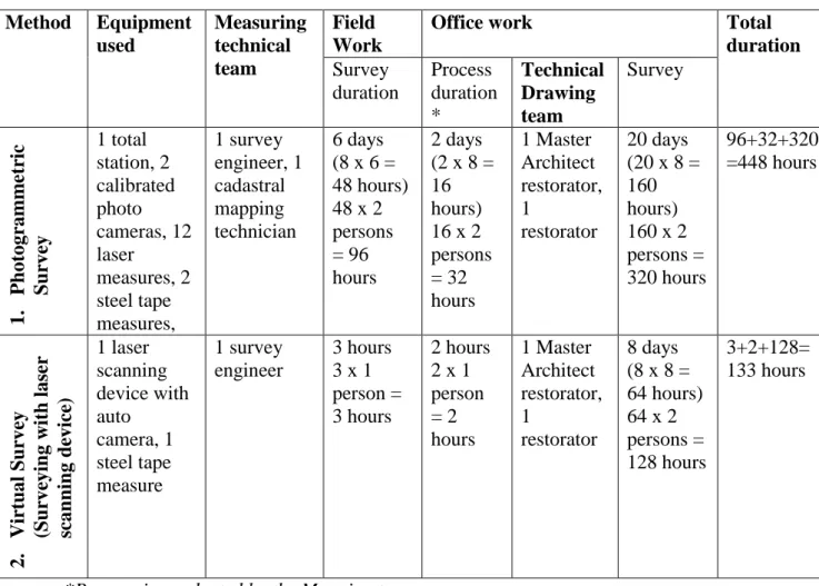
1 work day is considered as 8 hours. The data acquired is demonstrated in Table 1 below.
Table 1: Surveying with two methods Method Equipment used Measuring technical team Field Work
Office work Total
duration Survey duration Process duration * Technical Drawing team Survey 1. P h ot ogr amm etr ic S u rve y 1 total station, 2 calibrated photo cameras, 12 laser measures, 2 steel tape measures, 1 survey engineer, 1 cadastral mapping technician 6 days (8 x 6 = 48 hours) 48 x 2 persons = 96 hours 2 days (2 x 8 = 16 hours) 16 x 2 persons = 32 hours 1 Master Architect restorator, 1 restorator 20 days (20 x 8 = 160 hours) 160 x 2 persons = 320 hours 96+32+320 =448 hours 2. Vir tual S u rve y (S u rve yin g wit h lase r sc an n in g d evice ) 1 laser scanning device with auto camera, 1 steel tape measure 1 survey engineer 3 hours 3 x 1 person = 3 hours 2 hours 2 x 1 person = 2 hours 1 Master Architect restorator, 1 restorator 8 days (8 x 8 = 64 hours) 64 x 2 persons = 128 hours 3+2+128= 133 hours
*Process is conducted by the Mapping team.
In the light of this experience, it can be stated that the surveying of this site can be completed in 448 hours = 56 work days, using photogrammetric method, and 133 hours = 17 work days , using 1 laser scanning device. A total gain of time in 3 times more can be achieved. In such a case, many advantages are acquired in the entirety of large-scale survey works.
4. THE IMPACT OF WHOLISTIC DOCUMENTATION OF PROTECTED
SITES TO PROJECT AND PLANNING DECISIONS
Protected sites, intertwined in the daily life, are being rapidly falling into ruins with the intense pressure of the urban development surrounding it. This devastation is at a higher rate in urban protected sites, than archeological and natural protected sites (such as Side, Ephesus) which our not in urban areas. The management of protected sites are defined in accordance with the Reconstruction Plans for Protection, with the law number 2863 in Turkish Republic. Due to the differences in both quality and quantity of the natural and historical properties in all the protected sites, and since they are under the authority and responsibility areas of different managements (Ministry, Municipality etc.) it gets more difficult to protect the historical properties as required.
The planning and improving works to be conducted for the historical heritage, natural and urban properties in our cities, enables the city to reach higher values.
The content of the works required by the relevant legislation includes the assessments and drawings of the case with high accuracy surveys. Since urban data such as;
the relation between historical buildings and recent reinforced concrete buildings.
extensions on the historical building, unlicensed constructions,
the relation between historical buildings and streets and squares,
actual situation of the buildings in terms of function, clearance and aesthetics,
free space assessment,
actual accession situation,
ground, garden, road and pavement levels,
plant elements, trees,
urban furniture such as street lamps, waste bins etc.
can be assessed for all structures in 3-dimensional laser point clouds conducted in the field, these data shall lead new planning decisions to be taken from time to time. They will ease decisions on color, material and texture features of new architectural elements to be applied in the area. It will be possible to complete the preliminary preparations and decisions for the design works to be conducted in the area, via combined 3-dimensional laser point clouds, when the survey drawings are still being continued. With such an operation, the duration of the project shall be shortened in the end. The possibility to see and examine the area defined as a protected site in the digital environment as a whole, ensures rapid and accurate decisions by experts.
For example, when it is considered that the roof configurations applied in the protected site under study are acquired using 3-dimensional scanning, the most common roof profile throughout the region shall have been detected. When a proposal for a new construction in the protected site is brought forward, information on the roof configurations which has been conventionally applied in the area shall be already available, and knowledge and foresight on the style in which the new structure should be, shall already be present. In this way, typologies on the protected site under study can be defined in a short period, in a rapid manner. Supporting these data with photographs shot in the area, shall also shorten the duration of examination and decision processes. This also ensures a possibility to examine the harmony of the proposed new buildings to the old site, in terms of level and clearance, for reconstruction plans for protection in protected sites. Affects the decision making process positively during the constitution of the terms for new structures.
Although cadastral maps include structure, parcel, plot, field etc. Border information, this data may be insufficient in some cases. Therefore, in the scope of the planning works, a possibility of producing 3-dimensional laser data or 3-dimensional cadastral maps based on this data arises.
Since, with the contributions of technology, most real-like surveys can be conducted on vast areas, and 3-dimensional data can be associated with the Geographical Information System, it is also possible to examine dimensional images. By producing city models via 3-dimensional city surveys, this technology can be provided to the uses of many administrations. Cross examinations requested by the Geographical Information System can also be conducted.
5. ATTAINMENTS PROVIDED BY 3 DIMENSIONAL LASER SCANNING TECHNOLOGY IN DOCUMENTATION OF PROTECTED SITES
Since ground scans, i.e. scans conducted from the road level, lack data about the roofage, all the data on the area is acquired through combining aerial scans or scans conducted from a high location in the area with ground scans.
When 3-dimensional laser point clouds are supported with calibrated photography, all architectural features such as mass, volume, color, material, texture, pattern, and spatial data can be observed in 3 dimensional form. This possibility offers the expert working in the site a chance to comprehend and perceive the workspace as a whole, in a short time.
The details of the work to be conducted at the site, defines the quality and the quantity of the laser scanning to be performed in the area. However, for laser scans in protected sites, to conduct the scanning as detailed as possible and to acquire detailed site related data will be of great help for any kind of subsequent work at any scale in the site.
Laser scanning devices enable the sites where historical buildings are ample, to be surveyed in a rapid and effective manner. The advantages of using laser scanners in the protected sites where monumental buildings such as mosques, baths, churches and examples of civil architecture exist together, can be listed as such:
As it can both possible to scan a single historical building with high accuracy and speed, and also scan several adjacent buildings together, the relations between the buildings and details can be examined. For example, all the details such as the distance between the buildings, their corresponding dominance, effect, eave levels, balcony, bay windows, garden walls, stairs, pavement level can be detected all at once.
Small areas scanned in bits can be combined later, in digital environment to enable knowledge of the entirety of the site. This provides the possibility of observing, assessing and interpreting all the historical characteristics of the site together.
Human labour is decreased by 70%. Surveying can be conducted with fewer personnel. This affects the project production and delivery dates positively.
On-site working hours are decreased by 90%. In view of experience, the number of days in which the work is suspended due to negative external factors such as weather conditions did not exceed 1% of the total working days.
Detail works overlooked in the site can be realized in the office, as the building or all of the buildings can be seen together in digital environment.
It is possible to miss some details or overlook measurements in conventional surveying methods. But in laser scanning, the fact that all the details are acquired at once eliminates this possibility.
It brings forward the ease of remote surveying in complicated, inaccessible or dangerous places where conventional techniques are inadequate.
The possibility of working without a need for daylight (in night hours) is an important factor, and is a reason for preference in some cases.
It also helps analyses of panoramic data and urban conditions, apart from the buildings in the site.
Data acquired from the site are multipurpose;
e.g. Assume that a sectioning is being conducted which proceeds as road – city block – road – city block – road, like the city blocks in Chart 1. In a situation as such, the common method
is to draw a section of each building, to place them on the road level, and then to draw the section of another building which has a facade to the roar, and to place them on the road level. Here, in case of a mathematical calculation error, the section which is being formed can take more time than expected. Many professionals know from the experience that a 10 cm error on the road level can have huge consequences in the architectural section. However, data
acquired from 3-dimensional laser scanning devices offers great ease at this matter. Combined point cloud data of the site, offers possibilities of sectioning and drawing from any point desired.
Hence, if in a protected site, the data is acquired through laser scanning, it affects the work flow of the project in terms of duration, quality and accuracy in an utterly positive manner. This positive effect ensures the timely handover of the project to the management or the party who orders the work, and move on to application sooner. It offers a chance to interfere and repair our buildings which are on the edge of withering.
Laser scanning surveys provide benefits not only in project production, but also in other architectural processes. For example, assume that paint and white wash works are required for the facades of all the buildings, whether registered, or unregistered, in a protected site. This quantity survey can be priced conducted without a necessity of a drawn survey, using point cloud data. So, when a quantity survey is required, the scanning data, i.e. 3-dimensional images which consist of point clouds can be used, without a necessity of a drawn survey. Since deformation and sensitivity which have occurred on the historical buildings, can be detected using laser scanning, the method and process to be determined prior to the restoration application is also positively affected in a direct fashion.
6. CONCLUSION
It should be noted that it is necessary for the relevant ministry, in charge of the evaluation of cultural and natural properties and protected sites to be equipped with contemporary method, technology and techniques and should resort to employ qualified personnel to work on this subject.
In the event that documentation and surveying works of the protected sites country-wide to be conducted by the relevant authority, historical buildings which require protection would be recorded rapidly and in the case of future corrosion of the building, it would be possible to make use of the archived documents.
3-dimensional data acquired in the protected sites support the 2-dimensional base maps on which the work is conducted. Updating the site in 3-dimension ensures an accurate evaluation of present urban settlement, and correct comprehension of structural fittings and architectural elements such as:
Height of building,
Protection situation of the building,
Building – eave relation,
Building – garden relation,
Building – road,
Building – pavement,
Garden – road relation,
Bay and corbels,
Roof types,
Street lights,
Garden walls
Therefore, as it enables an ease for right decision-making and healthy planning for new urban applications to be performed on the field, they should be popularized.
It is necessary to delve into much more detailed studies for the applications in the protected sites, make examinations and synthesize the data with a holistic approach. This is the only way to ensure the conformity of any kind of application planned to be conducted in the site, with protection and goal criteria. To benefit from the improving technology all over the world, makes a dramatic difference in quick and accurate analyze, evaluation, synthesis processes in many respects.
When documentation and surveying works are to be conducted in protected sites larger than a specific size, virtual surveying – surveying acquired through 3-dimensional laser scanning – should be preferred as it is more efficient, effective, healthy, accurate and fast than other surveying methods.
Photograph 2: Data control and data transfer (Data is observed on the monitor, the frequency is determined, if scanning frequency is inadequate, a scanning with more frequent intervals is conducted –considering the lengthy duration, and a more detailed image of the facade of the building is acquired.)
Drawing 1: Street silhouette acquired via laser scanning. (This image is in sheer scale and level, and it can be brought to any desired scale.), Istanbul Fatih, Süleymaniye.
Drawing 2: Street silhouette of several city blocks (In area-wide works, project design process takes less time than expected and the prepared projects are in accurate scale and level.)
Drawing 3: An example of surveying and restoration work on the street scale, Istanbul Fatih, Süleymaniye.
Drawing 4: An example of urban design project (surveying and design works) prepared in a protected site which hosts many examples of civil architecture or monumental buildings, İstanbul, Eminönü.
REFERENCES
Istanbul Metropolitan Municipality, Bimtas Metropolitan Planning Directorate, Site works in various localities between, 2005-2012
H. Karabork, A. Goktepe, H. M. Yilmaz, O. Mutluoglu, F. Yildiz, M. Yakar, “3D modeling of historical and cultural properties via laser scanning and laser point measuring technologies and sensitivity research in 3d modeling and determination of application model”, Union of Chambers of Turkish Engineers and Architects, The Chamber of Survey and Cadastre Engineers, 12th Turkey Surveying Scientific and Technical Congress, 11-15 May 2009, Ankara.