V ^ V ¿ İ J ' " *; ^ > ц ^ íi :á i‘ \u г іі а Л 0 \y [.Л i -¡ K-^ . r ς ί θ· ' V . ^.'i i í»i i i’¿ C) ^ О, , і / г ' к 'ііі ' L "Г ·:/ ¿ t L · ^ Ά: W * ( У‘ СЙ .О .А
THE CYPRO-ANATOLIAN CONNECTIONS IN I'H E LATE BRONZE AGE
The Institute of Economics and Social Sciences of
Bilkent University
by
EKIN KOZAL
In Partial Fulfillment Of The Requirements For The Degree Of MASTER OF ARTS IN ARCHAEOLOGY AND HISTORY OF ART
in
THE DEPARTMENT OF
ARCHAEOLOGY AND HISTORY OF ART BILKENT UNIVERSITY
ANKARA
6Ю » s . Si
. т з
и ъ
I certify that I have read this thesis and in my opinion it is fully adequate, in scope and in quality, as a thesis for the degree of Master of Arts in Archaeology and History o f Art.
Assoc. Prof. Dr. Marie-Henriette Gates
I certily that I have read this thesis and in my opinion it is fully adequate, in scope and in quality, as a thesis for the degree of Master of Arts in Archaeology and History o f Art.
Dr. Norbert Karg
I certify that I have read this thesis and in my opinion it is fully adequate, in scope and in quality, as a thesis for the degree of Master of Arts in Archaeology and History o f Art.
Dr. Charles Gates
I certify that I have read this thesis and in my opinion it is fully adequate, in scope and in quality, as a thesis for the degree of Master of Arts in Archaeology and History of Art.
Prof. Dr. İlknur Özgen
I certify that I have read this thesis and in my opinion it is fully adequate, in scope and in quality, as a thesis for the degree of Master of Arts in Archaeology and History o f Art.
ABSTRACT
The relations between Anatolia and C3^rus in the Late Bronze Age have been neglected in contrast to the growing interest in the Eastern Mediterranean trade. The main goal of this thesis is to bring this subject to light.
These relations were attested in the Hittite sources for two centuries (ca. 1400- 1200 B.C.) and in Ugaritic sources in the 13th century B.C. Within this historical framework the connections are reviewed in different perspectives. Correlations between the historical sources and the archaeological evidence are proposed. In this period, friendly relations existed, wliich were implied in the written texts until the time shortly before the collapse of the Hittite Empire. From the 15th until the 13th centuries White Slip and Base Ring wares were exported to Cilicia, whereas in the 13th century the Red Lustrous Wheelmade Ware was transported to the Hittite capital thiough the Göksu Valley. The new ceramic distribution pattern in the 13th century shows the
increase of the Hittites’ interest in overseas activities. Besides, this was the time when the Hittite capital was moved to the land of Tarhuntassa. At the end of the 13th century B.C. with the military intervention of Hittites, Cyprus came under the control of the Hittite Empire. This was demonstrated in the archaeological record by the Hittite small finds in Cyprus.
In this preliminary study I have also touched upon the geophysical features of southern Anatolia and Cyprus, the distribution of the Late Bronze Age sites in both places, the climatic factors and conditions, which play a very important role in the ancient navigation and the physical layout of the coastlines. Conclusively, a synthesis of these various factors are put forward.
TÜRKÇE ÖZET
Geç Bronz Çağı Doğu Akdeniz ticaretine olan ve gittikçe artan ilgiye rağmen, bu dönemdeki Anadolu Kıbrıs ilişkileri incelenmemiştir. Bu tezin amacı bu konuyu gün ışığına çıkarmaktır.
Bu ilişkilerin varlığı Hitit kaynaklarında iki yüzyil süre boyunca (M.Ö. 1400- 1200) ve Ugarit kaynaklarında M. Ö.13. yüzyılda bilinmektedir. Bu tezde, belirtilen tarihsel süreç içerisinde ilişkiler değişik yönlerden incelenmiştir. Tarihsel kaynaklar ve arkeolojik buluntular arasındaki bağlantı ortaya konmuştur. İyi ilişkilerin, Hitit
İmparatorluğunun çökmesinden kısa bir süre öncesine kadar devam ettiği yazılı kaynaklardan anlaşılmaktadır. 15. ve 13. yüzyıllar arasında Beyaz Astarlı ve Halka Kaideli seramik türleri Kilikya Bölgesi’ne, 13. yüzyılda ise Kırmızı Boyalı Çarkta Üretilmiş seramik türü Göksu Vadisi üzerinden Boğazköy’e ihraç edilmiştir. 13. yüzyıldaki seramik dağılımı Hititlerin denizaşırı faaliyetlere artan ilgisini
göstermektedir. Ayrıca bu dönemde Hitit başkenti Tarhuntassa Bölgesi’ne
aktarılmıştır. 13. yüzyıl sonunda, Hititlerin Kıbrıs’a askeri müdahalesi sonucu, ada Hitit kontrolü altına girmiştir. Bu tarihi olay, Kıbrıs’ta bulunan Hitit küçük buluntularıyla arkeolojik yönden açıklanabilmektedir.
Bu ön çalışmada Güney Anadolu ve Kıbrıs’ın jeofiziksel özellikleri. Geç Bronz Çağı merkezlerinin dağılımı, antik dönemdeki denizcilik açısından önem taşıyan iklim koşulları ve kıyıların fiziksel yapısı da incelenmiştir. Sonuç olarak, yukarda belirtilen etkenlerin bir sentezi oluşturulmuştur.
I would like to thank İlknur Özgen for suggesting this interesting topic to me. 1 owe thanks especially to my advisor Marie-Henilette Gates for her patience, support and encouragement thi'oughout. I enjoyed writing my MA under her supervision. I extend thanks to Norbert Karg for his helpful comments and lending me a few books which are not available in the libraries. I would like to thank Charles Gates and Yaşar Ersoy for their comments and advises. I thank Ralf Becks for lending me his computer. I thank my family, Göksu Baysal, Sevil Сопка and Aylin Tuncer for their moral
support tİTi oughout.
ABSTRACT... i
ÖZET...ii
ACKNOWLEDGMENTS... İÜ TABLE OF CONTENTS... iv
LIST OF MAPS...Vi LIST OF FIGURES... vii
LIST OF TABLES... viii
LIST OF PLATES... ix
CHAPTER 1; INTRODUCTION...1
CHAPTER 2: GEOGRAPHICAL SITUATION... 3
2.1. Location of the island in the Eastern Mediterranean context...3
2.2. Physical features o f Cyprus...3
2.3. Physical features of the southern coast of Anatolia... 5
2.4. Climatic factors and currents affecting the north-south trade routes... 7
2.5. Conclusion... 11
CHAPTER 3: WRITTEN EVIDENCE... 12
3.1. Hittite Texts... 12 3.1.1. Diplomatic Texts...13 3.1.2. Historical Texts... 17 3.1.3. Religious Texts... 18 3.1.4. Conclusion... 18 3.2. Ugaritic Texts... ... 20 3.2.1. Diplomatic Texts...20
TABLE OF CONTENTS
3.2.2. Commercial Texts...23
3.2.3. Religious Texts... 23
3.2.4. A problematic text...24
3.2.5. Conclusion... 24
CHAPTER 4: ARCHAEOLOGICAL EVIDENCE... 26
4.1. Cypriot pottery in Late Bronze Age contexts of southern Anatolia... 26
4.2. Architecture... 50 4.3. Finds... 52 4.4. Conclusions... 55 CHAPTER 5: HARBORS... 58 5.1. Southern Anatolia... 60 5.2. Cyprus... 65 5.3. Discussion... 66 5.4. Conclusion... 69 CHAPTER 6: CONCLUSION...71 BIBLIOGRAPHY...74
1. The Mediterranean Region
2. Physical Features of Cyprus
3. Late Bronze Age Settlements of Cyprus
1. Sea level in the Mediterranean
2. Copper Sources in Cyprus
3a. Western Taurus
3b. Main Taurus, Anti-Taurus and Seyhan Lowland
4. The passes through the Taurus Mountains
5. Possible sea routes around the Mediterranean during the Late Bronze Age
6a. Winds and currents in the Mediterranean Sea in July
6b. Winds and currents in the Mediterranean Sea in September
7. The constancy of the currents in the Mediterranean sea in July
8. Distribution map of Red Lustrous Wheelmade Ware, White Slip II Ware and
Base Ring Ware
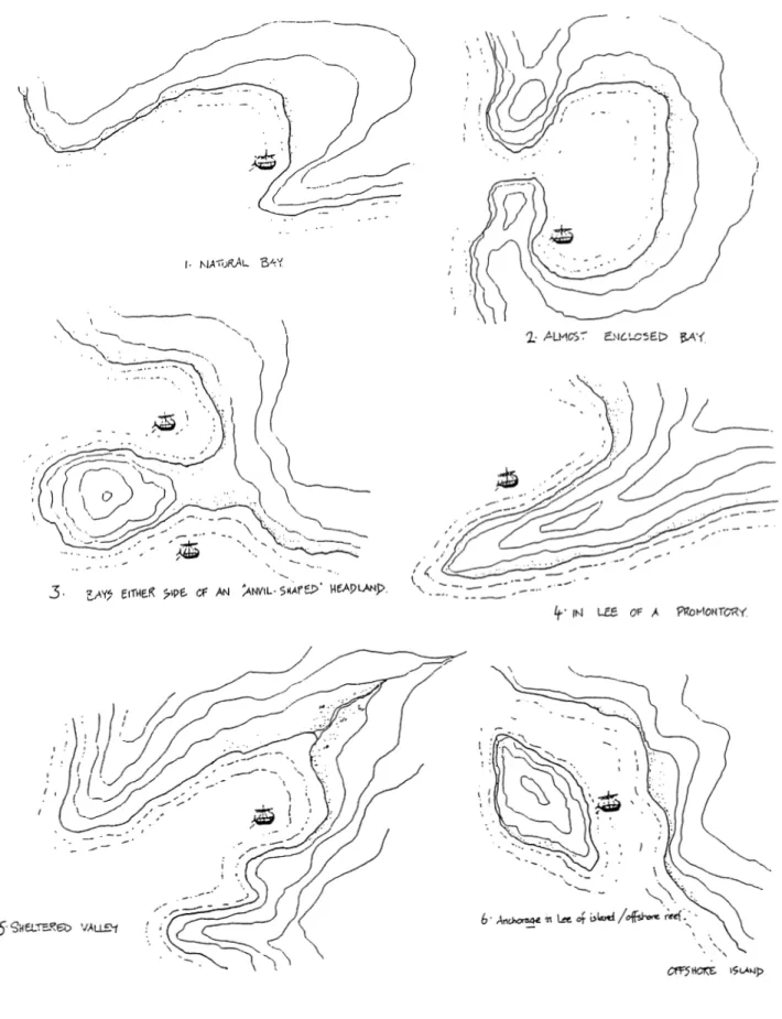
9a. Anchorages on high energy, clilTIined coasts
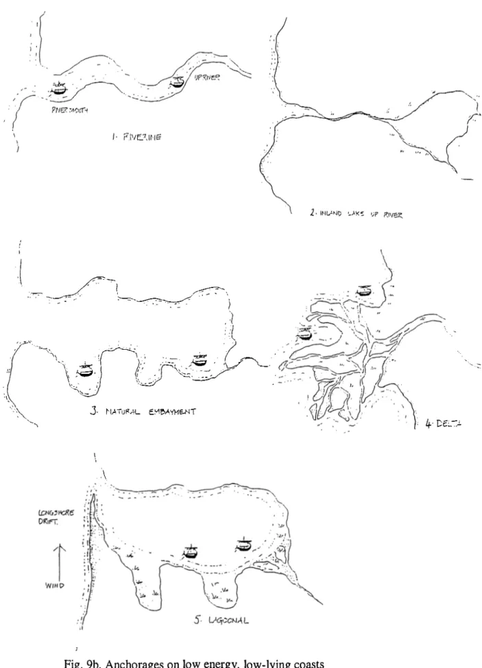
9b. Anchorages on low energy, low-lying coasts
10. Possible coastal palaeo-geograpliy of the Eastern Mediterranean in the second
millennium B.C.
11. The deltaic plain of Çukurova
12a. From Dalaman to Antalya
12b. The Gulf of Antalya
12c. From Anamur to Mersin
12d. The Gulf of İskenderun
13. Second millennium sites in the Konya Plain and the neighborhood
1 a. Wind patterns in Antalya in %
lb. Wind patterns in Mersin according to the occurrences per month within 42
years
lc. Wind patterns in Adana according to the occurrences per month within 41
yeai's
ld. Wind patterns in İskenderun according to the occurrences per month within 42
years
2. List of Hittite Great Kings
3. S tratigraphy of Mersin Yumuk Tepe
4. Stratigraphy of Middle and Late Bronze Age levels at Tarsus Gözlü Kule
5. Stratigraphy of Kinet Höyük
6. Stratigraphic sequence of Boğazköy
7. Late Bronze Age chronology of Cyprus
LIST OF PLATES
PlateNo. 1: Garstang 1939, 144, PI. 58:4. No. 2: Garstang 1939, 144, PI. 58:6
Plate 2
No. 1-3: Goldman 1956, 182, fig. 293, no. 945.
Plate 3
No. 1, 2: Goldman 1956,19-20; fig. 329, no. 1248. No. 3: Goldman 1956, 220; fig. 329, no. 1249. No. 4: Goldman 1956, 220; fig. 329, no. 1250. No. 5: Goldman 1956, 220; fig. 329, no. 1251. No. 6: Goldman 1956, 220; fig. 329, no. 1252. No. 7: Goldman 1956, 220; fig. 329, no. 1253. Plate 4
No. 8: Goldman 1956, 218; fig. 328, no. 1229. No. 9: Goldman 1956, 218; fig. 328, no. 1230. No. 10: Goldman 1956, 218; fig. 329, no. 1232. No. 11: Goldman 1956, 218; fig. 329, no. 1233. No. 12:Goldman 1956, 218, fig. 329, no. 1234.
Plate 5
No. 13: Goldman 1956, 214, fig. 322 and 385.
Plate 6
No. 14: Goldman 1956, 229, fig. 328, no. 1372. No. 15: Goldman 1956, 204, 218, fig. 328, no. 1226. No. 16: Goldman 1956, 204, 218, fig. 328, no. 1227. No. 17: Goldman 1956, 205, 220, figs. 329, 387, no. 1254. No. 18, 19: Goldman 1956, 219, fig. 329, no. 1247.
No. 20: Goldman 1956, 200, fig. 315, no. 1085. Plate 7
No. 2: Postgate et al. 1996, 180-82, fig. 17, no. 3. No. 3: Postgate et al. 1996, 180-82, fig. 17, no. 2. No. 4: MeUaart 1958, 330, 341, PI. 4, no. 38. No. 5: Mellaart 1958, 330, P1.4, no. 36. No. 6: French 1965, 184-5, fig. 8:4.
Plate 8
No. 1: French 1965, 201, fig. 11, no. 28. No. 2: French 1965, 195, 201, fig. 11, no. 27. No. 3: Mellaart 1958, 330, 341, PI. 4, no. 37.
Plate 9
No. 1: French 1965, 188, 197, fig. 4, no. 1.
No. 2: French 1965, 188, 197, fig. 3, no. 23.
No. 3; French 1965, 188, 197, fig. 3, no. 24.
No. 4: French 1965, 188, 197, fig. 3, no. 25.
No. 5: French 1965, 188, 197, fig. 3, no. 27.
No. 6: French 1965, 188, 197, fig. 4, no. 2.
Plate 10
No. 1: French 1965, 189, 198, fig. 5, no. 17.
Plate
No. 1: French 1965, 189, 198, fig. 9, no. 23.
Plate 12
No. 1: French 1965, 189, 198, fig. 12, no. 6.
Plate 13
No. 1: Fischer 1963, 149, No. 1102, PI. 122: 1102. No. 2: Fischer 1963, 150, No. 1113, PI. 124: 1113. No. 3: Fischer 1963, 150, No. 1109, PI. 124: 1109. No. 4: Fischer 1963, 150, No. 1106, PI. 124: 1106. No. 5: Fischer 1963, 149, No. 1103, PL 124: 1103.
No. 6: Fischer 1963, 149, No. 1104, PI. 124: 1104.
Plate 14
No. 8: Fischer 1963, 151, PI. 126; 1142.
No. 9: Fischer 1963, 126, No. 443, No. 1143, Pis. 45: 443, 125: 1143. No. 10: Fischer 1963, 151, PI. 126; 1144.
Plate 15
No. 11: Fischer 1963, 150, No. 1124, Pis. 122: 1124, 124: 1124.
No. 12; Fischer 1963, 150, No. 1122, PI. 124: 1122.
No. 13: Fischer 1963, 150, No. 1123, PI. 124: 1123. No. 14: Fischer 1963, 150, No. 1125, PI. 124: 1125. No. 15: Fischer 1963, 150, No. 1127, PI. 124: 1127. No. 16: Fischer 1963, 150, No. 1128, PI. 124: 1128. No. 17: Bittel 1957, Fig. 13 right.
No. 18: Bittel 1957, Fig. 13 left.
No. 19: Fischer 1963, 151, No. 1140, PI. 124: 1140.
No. 20: Fischer 1963, 151, No. 1145, PI. 126: 1145. No. 21: Fischer 1963, 151, No. 1146, PI. 126: 1146.
Plate 16
No. 22: Fischer 1963, 149, No. 1097, PI. 122: 1097. No. 23: Fischer 1963, 149, No. 1090, PL 124: 1090 No. 24: Fischer 1963, 126, Pis. 38: 424, 45: 424. No. 25: Fischer 1963, 151, Pis. 125; 1141, 126: 1141. No. 26: Fischer 1963, 126, PI. 45: 429.
Plate 17
No. 27: Neve 1996, 29, Fig. 67.
No. 28: Müller-Karpe 1988, 48, Type K 9b:l, PI. 8.
No. 29: Müller-Karpe 1988, 145, Libationsarme No. 9, PI. 48.
Plate 18
No. 30: Fischer 1963, 149, No. No. 31: Fischer 1963, 149, No. No. 32: Fischer 1963, 149, No. No. 33: Fischer 1963, 149, No. No. 34: Fischer 1963, 149, No. No. 35: Fischer 1963, 151, No. No. 36: Bittel 1937, PI. 16: 4. No. 37: Bittel 1937, PI. 16: 5.
1098, PI. 124: 1098. 1089, PI. 124: 1089. 1091, PI. 124: 1091. 1095, PI. 124: 1095. 1099, PI. 124: 1099. 1136, PI. 124: 1136.
Plate 19
No. 38: Bittel 1937, PI. 16: 1. No. 39: Bittel 1937, PI. 16: 2. No. 40: Bittel 1937, PI. 16: 3.
Plate 20
No. 41: Müller-Karpe 1988, 140, Type B26:3, PI, 46. No. 42: Müller-Karpe 1988, 140, Type B26:4, PI. 46. No. 43: Müller-Karpe 1988, 48, Type K9a:l, PI. 8. No. 44: Müller-Karpe 1988, 48, Type K9a:2, PI. 8. No. 45: Müller-Karpe 1988, 48, Type K9b:2, PI. 8. No. 46: Müller-Karpe 1988, 139, Type B22:4, PI. 46. No. 47: Müller-Karpe 1988, 139, Type B22:8, PI. 46. No. 48: Müller-Karpe 1988, 30, Type Lf 2:6, PI. 1. No. 49: Müller-Karpe 1988, 30, Type Lf 2:6, PI. 2.
Plate 21
No. 50: Müller-Karpe 1988, 145, Libationsarme No. 1, PI. 48. No. 51: Müller-Karpe 1988, 145, Libationsarme No. 2, PI. 48. No. 52: Müller-Karpe 1988, 145, Libationsarme No. 3, PI. 48. No. 53: Müller-Karpe 1988, 145, Libationsarme No. 4, PI. 48. No. 54: Müller-Karpe 1988, 145, Libationsarme No. 5, PI. 48. No. 55: Müller-Karpe 1988, 145, Libationsarme No. 10, PI. 48. No. 56: Müller-Karpe 1988, 145, Libationsarme No. 12, PI. 48.
Plate 22
No. 1: Özgü9 1982, 102, PI. 47:4a-b.
No. 2: Özgü9 1982, 102, Fig. 35.
No. 3: Özgü9 1982, 102, Fig. A:15.
Plate 23
No. 1: von der Osten 1937, 165, 190, Fig. 207:c 1276. No. 2: von der Osten 1937, 165, 190, Fig. 207:c 1277.
Plate 24
Plate 25
No. 2: Ko?ay 1951, 124, PI. LX 3 a/b.
No. 3: Ko§ay& Akok 1966, 170, PI. 17:h 153. No. 4: Ko§ay & Akok 1966, 170, PI. 17:j 154. No. 5: Ko?ay & Akok 1966, 170, PI. 17:1 108. No. 6: Ko§ay <fe Akok 1966, 170, PI. 17:1 109. No. 7: Ko§ay& Akok 1973, 80, PI. 38:A1. n 109. No. 8: Ko§ay & Alcok 1973, 80, PI. 82:Al. p 156. No. 9: Ko?ay & Akok 1973, 80, PI. 38:A1. r 43.
Plate 26
No. 10: Ko§ay& Akok 1966, 152, PI. lOLAl. g 284.
Plate 27
No. 1: Dupre 1983, 53, Pis. 41:247, 43:247. No. 2: Dupre 1983, 53, PI. 41:250.
Plate 28
No. 1: Griffin 1980, 97, Pis. 16:H, 17:F. No. 2: Griffin 1980, 96, Pis. 16;D, 17:C.
Plate 29
No. 3: Griffin 1980, 89, PI. 10:H. No. 4: Griffin 1980, 88, PI. 10:1. No. 5: Griffin 1980, 88, PI. 10:E.
Plate 30
No. 6: Ertem 1988, 18, Cat. No. 31.
Plate 31
Plate 32
No. 8: Ertem 1988, 18, Cat. No. 33.
No. 9: Ertem 1988, 18, Cat. No. 34.
Plate 33
No. 1: Özgüç 1982, 115, PI. 55:14. No. 2: Neve 1980, 304, lig.22.
Plate 34
N o.l: South 1995, 41.
Plate 35
No. 1: Âström 1991,100, fig. 1. No. 2: Masson 1964, 205, fig.6. No. 3: Reyes 1991, 120, fig.l: 8. No. 4: Schaeffer et al. 1968, 264, fig.l. No. 5: Dikaios 1971, PI. 182, 4c. Plate 36
CHAPTER 1: INTRODUCTION
This thesis will review the relations between Cyprus and Anatolia in the late second millennium B.C. The main goal is to bring this subject to light, since it has been neglected in the analysis of Eastern Mediterranean trade. In this way, the relations between (he island and the closest mainland should acquire a more visible definition.
7’his subject first attracted the interest o f the scholaidy world, when the Hittite and Ugaritic sources were recovered in the late 19th and early 20th centuries. These yielded historical information about the relations between Anatolia and Cyprus. However, the connections in the archaeological record were disregarded. Therefore, the historical evidence could not be confirmed in the archaeological record. In this thesis, I attempt to show that a correlation between the written and the archaeological evidence can be made. The history of the relations covers the period o f two centuries, from 1400 B.C. until the collapse of the Hittite Empire. The historical phase
corresponds, in archaeological terms, to the second hafrof the Late Bronze Age (LC II). The collapse of the Hittite Empfre coincides with LC IIIA:1 period (1225-1150 B.C.) in Cypriot chronology, when major destructions occurred at Late Bronze Age sites throughout the island. The post-destruction and final Late Bronze Age is characterized by enormous changes in Cyprus. These are dramatically attested in the appearance of ashlar masonry, Mycenaean pottery types and man-made harbors. Since this per iod is not documented by written material and has a very different cultur e, it will be excluded Irom this thesis.
Within this pr ecise historical framework, this thesis will review the connections between Cyprus and Anatolia from several perspectives. The coastal geophysical features, which play a very important role in the distribution o f the Late Bronze Age
sites, will be presented both for Cyprus and Anatolia. The climatic factors and
conditions, on which ancient navigation depended, will be outlined. These will be the subjects of chapter two.
The next chapter will summarize the Hittite and Ugaritic sources. These describe the nature of formal relations between Cyprus and the Hittite world.
In chapter four, which reviews the archaeological evidence, correlations between the written evidence and ai'chaeological record will be proposed.
In the light of these demonstrated contacts, the physieal layout of the coastlines of southern Anatoha and northern Cyprus ai’e discussed in the concluding chapter. It will consider changes in the coastlines, and the locations of potential anchorage sites in relation to the Late Bronze Age sites in the hinterland.
In conclusion a synthesis of these various factors will be put forward. In this way the neglected issue of relations between Cyprus and Anatolia will be reviewed and the need for further research in this subject will be demonstrated.
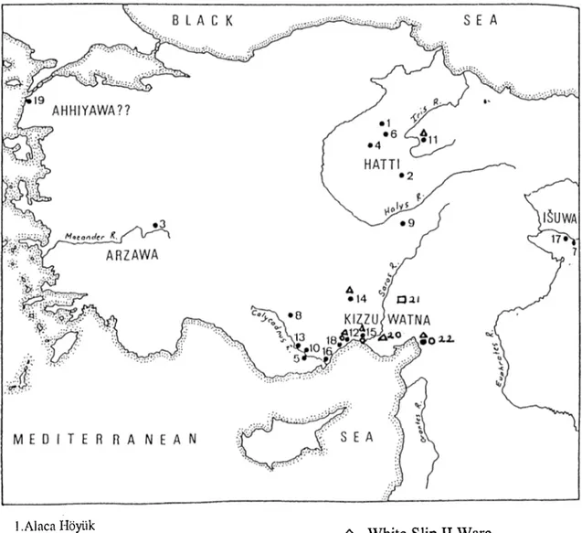
2.1. Location of the island in the Eastern Mediterranean context (Map 1)
Cyprus lies on the 35th meridian in the northeast corner of the Mediterranean.' It is located 65 km south of Anatolia, 130 km southwest o f Hatay,^ 95 km west of Syria, 400 km north of Egypt and 480 km east of Aegean islands. The closest island in the Aegean is Rhodes.^ The Greek mainland is 750 km away from the island.'*
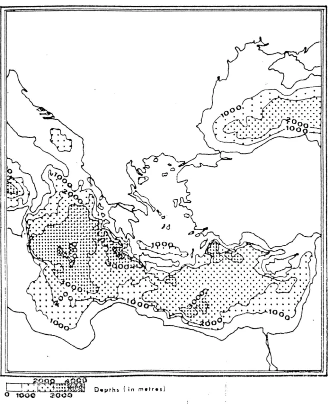
It is the third biggest island in the Mediterranean after Sicily and Sardinia with an area of 9251 m^ .5 it measures approximately 224 km in the east-west direction and 100 km in the north-south du'ection.*^
There are major differences in the sea level around the island. The sea level is 1000 m deep between Cyprus and Anatolia and also between the island and the Levant. It drops to 2000 m in the south, and 2500-4000 m in the west of the island (fig .l).’
2.2. Physical Features of Cyprus (Map 2)
There are tlrree main geophysical features on the island. These are two
CHAPTER 2: GEOGRAPHICAL SITUATION
' G. Hill, A History o f Cyprus (London 1972) 1. 2 P.-J, Albrecht, Nord Zypern (Berlin 1993) 38.
^ A. B. Knapp, ’’Emergence, Development and Decline on Bronze Age Cyprus” in C. Mathers and S. Stoddarl eds.. Development and Decline in the Mediterranean Bronze Age (Sheffield Archaeological Monographs 8) (1994) 271.
^ Albrecht (supra n. 2) 38.
^ Hill (supra n. 1) 1; Albrecht (supra n. 2) 38; Knapp (supra n. 3) 271. ^ Albrecht (supra n. 2) 38.
2 E. K. Mantzourani and A. J. Theodorou, ”An Attempt to Delineate the Sea-Routes between Crete and Cyprus during the Bronze Age“ in V. Karageorghis ed.. The Civilizations of the Aegean and Their Diffusion in Cyprus and the Eastern Mediterranean, 2000-600 B. C. (Larnaca 1989) 47, fig.5.
mountain ranges: the Kyrenia range (Beşparmak Dağları)* * in the north and the Troodos mountains in the southwest, and in the center the Mesaoria Plain (Mesarya Ovası) between them.^
The Kyrenia range runs along the north coast between Panagra (Geçitköy) in the west and Ephtankomi (Yedikonuk) in the east. A hilly landscape starts on either side o i the mountain until Morphou Bay (Güzelyurt Körfezi) in the west and in the Karpas Peninsula in the east.'^ There is a narrow plain, no more than five km in width, in the northern side of the Kyrenia Range. There ai'e at least tlii'ee passes through the Kyrenia range to the Mesaoria Plain. > ·
The Mesaoria Plain is 0-230 m above the sea level. It is an alluvial plain except for the limestone plateau in the middle, which is at some place's covered with a layer
o i terra rossa (red soil). It plays an important role in today's grain production. >2 Two large streams, Pedias (Kanlidere) and Yialias (Çakıllı Dere) come from the eastern side of Troodos and reach the sea at Salaniis Bay. Another river, Ovgos (Dar Dere) is
flowing from east to west and enters the sea at Morphou B a y .*2
The Troodos massif covers the south and southwestern parts of the island. Its highest peak is 1953 m high. It is rich in copper deposits, which are located on the foothills with rivers flowing in all dkections (fig. 2). None of the rivers on Cyprus is perennial because they depend on rain and snowfall, and therefore in summer are dry.
^ The Turkish names of the places are given in brackets only when they are different from the Greek. 9 H. W. Catling, ’’Patterns of Settlement in Bronze Age Cyprus“ OpAth 4 (1963) 133-134; Hill (supra n.l) 6-8; V. Tatton Brown,/l/ic/ent Cyprus (London 1987) 7; Knapp (supra n. 3) 271-72.
Catling (supra n. 9) 133. ^ * Knapp (supra n. 3) 272. 12 Ibid.
The valleys of the rivers allow travel tlirough the region.*^
2.3 Physical features of the southern coast of Anatolia
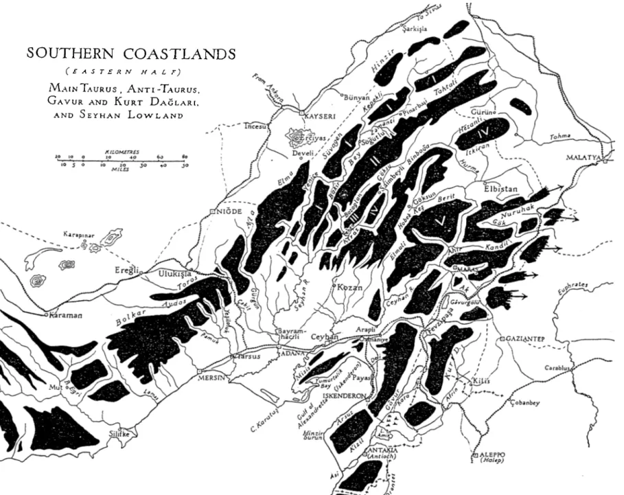
The Mediterranean coast of Anatolia covers the area fiom Dalaman to İskenderun Bay, a distance o f 770 km.·'’ It is divided into four main regions:
a) The western Taurus, including the lak e district' and the Antalya Plain (fig. 3 a)
b) The main Taurus (fig.3b) c) The Seyhan lowland (fig.3b)
d) I'he 'Anti-Taurus', the Gâvur and the Kurt Dağlar*^ (fig.3b)
a) The western Taurus extends from the Dalaman River in the north-east
direction as four ranges, separated by rivers and valleys. These ranges are
perpendicular to the coastline Irom the Dalaman River to Cape Gelidonya and some o f its rivers flow into the sea. The "lake district' is situated in this part of the Taurus Mountains, close to the Anatolian Plateau where they are fed by the rivers flowing in the north-cast direction. The four ranges turn toward the southeast. The Antalya Plain is situated between the western and eastern ranges. The eastern range is running perpendicular to the coast between Anamur and Silifke and is very similar in its characteristics to the western range. In this region it is difficult to travel inland
14 15
Knapp (supra n. 3) 272.
Turkey Vol. I, Geographical Handbook Series, Naval Intelligence Division (1942) 142. Turkey (supra n. 15) 144-45.
because of the mountains.*^
b) The main Taums consists o f the Bolkar, Toros and Ala Dağları. This range
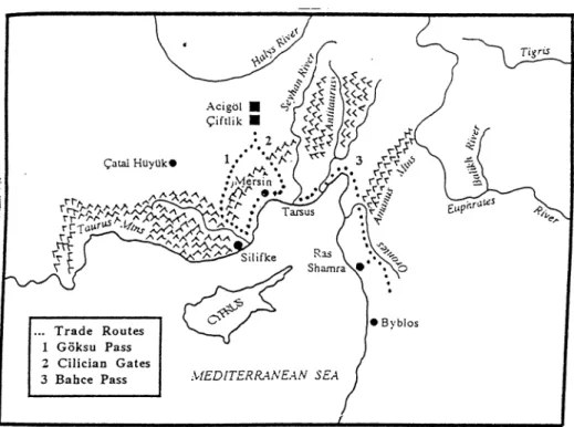
runs parallel to the coast, leaving a coastal strip between the sea and itself from Silifke as far as Mersin. The coastal strip becomes wider to the east of Mersin. Rivers originate from these mountains and flow southwards into the sea and northwards to the plateau.'* There are four passes between the Anatolian Plateau and the coastline. The first one is the valley o f the Lamas (Göksu) River, and is called Göksu Pass (fig.3b and 4). The Çakit Gorge and its valley form a natural passage between the coastline and the plateau. This passage, the Cilician Gates (Gülek Boğazı), represents the major route into central Anatolia (fig.3b and 4). The third is formed by the valley of the Gürgün River and the fourth, which is the Bahçe Pass (fig.3b and 4), by the Yenice River.
The Bolkar Mountains are rich in metal deposits. Lead and zinc are found there, usually mixed with traces of gold and silver.^® Besides, gold is found in considerable amounts in the Bolkar M o u n ta in s.T h e re are very few copper deposits in the Taurus
Range.22
During the last decade, a debate has arisen about the possibility o f ancient tin processing in Göltepe, and tin mining at Kestel near Celaller village in the Bolkar Mountains. The director o f this research, Aslihan Yener, put forward that tin was
Turkey (supra n. 15) 145-49. Turkey (supra n. 15) 150.
The first, second and the fourth passes are mentioned in S. R. Steadman, ’’Isolation or Interaction: Prehistoric Cilicia and the Fourth Millennium Uruk Expansion” JMA 9 (1996) 134-35; the third pass is mentioned in Turkey (supra n. 15) 152.
Turkey Vol.2, Geographical. Handbook Series, Naval Intelligence Division (1943) 123-24. Turkey (supra n. 20) 124.
mined and processed in that region in the Early Bronze Age.^^ These and related arguments have been hotly contested on archaeological and scientific grounds.2“* It is still an open question whether these iTiines were worked for tin.
c) The Seyhan Lowland is bordered by the main Taurus range in the north, Anti-Taurus and Amanos Mountains in the east, the Mediterranean Sea in the south and the eastern range of the western Taurus. The coastal line is narrow between Silifke and Mersin. To the east of Mersin, the coastal strip becomes wider; therefore a coastal plain was formed by two major rivers, the Seyhan and the Ceyhan. The plain becomes very narrow again to the north o f the İskenderun Bay. There are the
"Amanus Gates (Kaleköy) at the north end of the plain.
d) The Anti-Taurus is located north of the Seyhan Plain and it is in the
alignment of the Main Taurus. It has five ranges with rivers, which feed the Seyhan and valleys in between. The Turkish names of the Amanus Mountains are Gavur Dağ and Kurt Dağ in the south and Nur Dağ in the north. The rivers from the Amanus Mountains feed the Ceyhan and the Asi (Orontes). The Ceyhan enters the sea at the northwest o f the İskenderun Bay and the Asi to the southwest of Antakya.
P.S. De Jesus, ’’Metal Resources in Ancient Anatolia” AnatSi 28 (1978) 99, map 1.
K. A. Yener and H.Ozbal, ’’Tin in the Turkish Taurus Mountains: The Bolkardag mining district”
Antiquity 61 (1987) 220-26; K.A. Yener and P.B. Vandiver, ’’Tin Processing at Goltepe, An Early Bronze Age Site in Anatolia” A/A 97 (1993) 207-238; K.A. Yener and P.B. Vandiver, ’’Reply to J.D. Muhly 'Early Bronze Age Tin and the Taurus'” AJA 97 (1993) 255-64.
24 J.D. Muhly, ’’Early Bronze Age Tin and the Taurus” AJA 97 (1993) 239-53; J.D. Muhly, F. Begemann, O. Oztunali. E. Pemicka. S. Sclunitt-Strecker, G. A. Wagner, “The Bronze Age Metallurgy of Anatolia and the Question of Local Tin Sources” in E. Pernicka, G.A. Wagner eds., Arcliaeometiy
'90, International Symposium on Archaeometry (Heidelberg 1991) 209-20; E. Pernicka, G.A. Wagner, J.D. Muhly. O. Qzlunali. “Comment on llie Discussion o f Ancient Tin Sources in Anatolia JMA 5\1 (1992)91-98.
2.4. Climatic factors and currents affecting the north-south trade routes
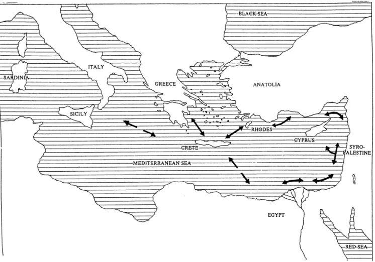
The maritime trade routes in the Eastern Mediterranean in the Late Bronze Age have been determined as anticlockwise, according to the archaeological and textual evidence as well as physical factors, which are winds, currents and littorals. The trade routes demonstrate the relations between the Aegean and the Eastern Mediterranean basin. In other words, the trade routes show mainly west-east direction to the south and east-west to the north of Cyprus (fig.S).^^ For the Aegean and the Eastern Mediterranean, currents and winds allow only anticlockwise routes unless it was possible to sail against the currents and/or the winds.
Only the currents and the winds affecting the trade in the north-south and south- north dh ections will be discussed here, since the other classes of evidence will be the subjects of later chapters.
Along the southern coast of Anatolia, the winds change directions and frequencies at different times of the year (Table la-d). Statistics will be shown here from four modern cities, Antalya, Mersin, Adana and İskenderun. The first three cities show a similar pattern to each other, whereas İskenderun has a different wind pattern.
In Antalya, in December and the fii'st thi'ee months o f the yeai' the north wind is dominant in the region. In April the north wind is still dominant but the calm days make up a considerable percentage. From May until October, the calm days are the most common. In November, the north wind becomes more frequent, but calm days
D.E. McCaslin, Stone Anchors in Antiquity: Coastal Settlements and Maritime Trade-routes in the Eastern Mediterranean ca. 1600-1050 B. C. (Göteborg 1980) 102-7.
are as frequent as in the previous months. The south wind is the second most frequent wind from March until September.^»
In Mersin there are similar wind patterns. In the first thi'ee months of the year the north wind is dominant, whereas in April, May, June, July the southwest and south winds are most common. In August north and south winds are frequent, in contrast to the last tlu'ee months of the year, when the north wind becomes most common again.^9
Adana has the same wind patterns as Mersin, since they are very close to each
other,^9
In contrast to Antalya, Mersin and Adana, İskenderun has a totally different wind pattern. In the first thi-ee months of the year- southeast winds are dominant. Until June west and northwest winds are the most common and from June until September west wind becomes dominant. Like the first three months, the last three months of the year the wind blows most from the southeast.^*
Besides wind patterns, the current in the Eastern Mediterranean plays an
important role in determining the trade routes. The current runs east-west in the north of Cyprus ffig.6a-b),^2 which is not lavorable for sailing in the north-south dkection or vice versa. However, for July the constancy of the currents are between 25 and 49
Turkey (supra ii. L5) 402. Meteorological office in Turkey. Ibid.
31 Ibid.
32 0 . Höckmann, ’’Frühbronzezeitliche Kulturbeziehungen im Mittelmeergebiet unter besonderer Berücksichtigung der Kykladen” in H.G.Bucholz Ägäiic/re Bronzezeit (Dannstadt 1987) 62-63, fig.9a- b.
percent (fig.7).^^ This shows that there ai’e days in July without the current running from east to west.
Conclusion
The northern coast of Cyprus faces the southern coast of Anatolia. The
northwestern coast of Cyprus, Morphou Bay and Chrysochou Bay, are hieing the Gulf of Antalya. The coast north of the Kyrenia Range is opposite to Rough Cilicia. The northern coa.st is southwest o f the region from Silifke to İskenderun G ulf Therefore, if possible, sailing between these two regions would be in northwestern, north and northeastern, and opposite directions.
Do the climatic conditions allow sailing in the dh'ections mentioned above? In southern Anatolia, except for the İskenderun Gulf, northerly and southerly winds are dominant throughout the year". The south winds are most frequent between May and August, whereas in the other months of the year the north wind is dominant. Although southerly winds are prevailing during the sailing season (May until September), northerly winds occur as well. Therefore it is possible to sail from north to south as well, although the ships had to wait for the northerly winds, fhe winds are favorable for sailing between these two regions, without taking the currents into consideration. The currents are not suitable for such sailing but since they are not constant at least half of the summer,^'' the days without east-west current presented suitable options.
Therefore, it might have been possible to sail with the appropriate wind during
C. Lambrou-Phillipson, ’’Seafaring in the Bronze Age Mediterranean” in R. Laffineur and L Basch eds., TIuilassci. L'égée préhistorique et la mer, (Aegaeum 7) (Liège 1991) 11-20.
The month July is taken as representative here, see fn. 33.
the days when the currents were not running in the east-west direction. In addition, the ships could have sailed between these regions during the days with current, but only if they could sail cutting the current at right angles.
It is evident from the written texts that there was a connection between Alasia
(Cyprus)-^5
and the Hittite world, most probably via Flat Cilicia. This can beconfirmed with the archaeological record as well. This leads to investigating the possible routes between Cyprus, the southern coast of Anatolia and even the
Anatolian Plateau. The probability of the sea journey was demonstrated above. The inland route must have been through the passes in the Taurus Mountains.
The north coast of Cyprus is closest to south Anatolia. Therefore, 1 assume that this northern region played a considerable role in their- relations, especially the western end of the coast, which has a hilly landscape and is closest to the copper- mines in the northern foothills o f the Troodos Mountains.
Besides the closest route, it might have been possible to travel from the eastern and southern coast of Cyprus to Anatolia. Since it was possible to travel to the east, to the Syrian coast,^*^ the coastline could have been followed and the Anatolian coast could be reached indirectly from there.
Here, I attempted to show the probable routes between southern Anatolia and Cyprus for the fir-st tirne. The distance is close and under adequate conditions sea tr avel must have been possible. The written and archaeological evidence confirm this. These will be reviewed in the next chapters.
this thesis, the equation of Alasia to Cyprus is accepted. McCaslin (supra n. 27) 105, fig. 36.f
CHAPTER 3: WRITTEN EVIDENCE
Written sources are very important because they not only help to reconstruct historical events and historical geography, but they also show the relationship, even the nature of the relationship, between the lands. However, in reviewing the relations of Alasia to Anatolia in the written texts, one comes across difficulties in understanding the nature of relationships because the texts do not give every kind of information, and the archaeological evidence is surprisingly rare.
In this chapter, only Hittite and Ugaritic sources will be reviewed. The
Egyptian texts are deliberately excluded, because they do not yield information about the relations of Alasia to Anatolia.
3.1. Hittite Texts
Eleven Hittite texts concerning Alasia were found in Boğazköy, the ancient Hittite capital Hattusa. The documents were written on clay tablets in Hittite cuneiform. Alasia was mentioned in Hittite written sources between ca. 1400-1200 B.C.^’ This covers the time from the reign of Arnuwanda I to the last Hittite king Suppiluliuma II (Table 2).^* The dating of some of these clay tablets have been debated and different dates have been suggested. The tablets show correspondence between Alasia and the Hittite Kingdom, but the nature of the relationship remains open to interpretation, because the archaeological evidence is insufficient to support the historical events mentioned in the texts. Here the texts will be reviewed according to their contents. They are mainly diplomatic texts. Some o f these relate to the
.37
banishments from the Hittite land to Alasia. Alasia was mentioned also in religious texts as well as in one historical text.
3.1.1. Diplomatic Texts
These texts refer to diplomatic relations and correspondence between Hatti and Alasia.
The Madduwattas Text
The Madduwattas text (KUB XIV 1)^^ is the earliest Hittite text, in which Alasia is mentioned, according to a re-examination mainly in the light of new
comparative philological evidence.“*® The text was first dated to around 1200 B.C. by Goetze“** and later to about 1400 B.C., before the reign of Suppiluliuma I by Otten.^^ Georgiou claims that the events of the Madduwattas text may belong to the reign o f two Hittite kings, Tudhaliya III and Arnuwanda I. She relates the expansionist policy of Tudhaliya III, the mention of two kings in the text and O tten's dating of the text philologically to the turn of the fifteenth to the fourteenth century, as the basis for her argument.“*^
The Madduwattas text is a letter, which was exchanged between the Hittite king and Madduwattas. The text is as follows:
“The Land ofAlasiya is a Land of the Hittite king and brings him tribute. Why have you
taken it? ’ But Madduwatta answered: ‘The Land of Alasiya was disturbed by Attar.siya and the Man
H. Georgiou, “Relations between Cyprus and the Near East in the Middle and Late Bronze Age“
Levant \ I (1979) 100.
F. Sommer, Die Ahhijava-Urkunden (München 1932) 329-49.
H. Otten, Sprachliche Stellung und Datierung des Madduwatta-Textes (Studien zu den Bogazköy- Texten 11) (Wiesbaden 1969).
Sommer (supra n. 39) 329. Otten (supra n. 40) 36. Georgiou (supra n. 38) 88-89.
ofPiggaya. Blit the father of the Hittite king did not subsequently write to me, the father of the
Hittite king never stated to me, "The Land of Alasiya is mine. Leave it so!" If now the king demands
back the prisoners taken from Alasiya, I will give them hack to him.
According to Georgiou, Alasia was not under Hittite control but it was important to the Hittites economically and in a militai'y sense. She argues that Alasia was independent, since it was not mentioned as a vassal state in the text.''·’ Hellbing also argues that Alasia was not under Hittite control because Madduwattas did not know that it belonged to the Hittite king and could not argue with it if he knew it.“^
On the other hand, the Hittite king claims that Alasia belongs to him'*^ but it is not clear in what sense. In the text it is obvious that the Hittite king claimed his political power to protest the invasion of Alasia by a foreign power and the
imprisonment of the people. This may be because, as Georgiou suggested, the island was important to him and/or Alasia was under political protection of the Hittite king. If so, Alasia was protected from the foreign powers, under the Hittite king’s influence, and therefore could keep its independence perhaps by paying tribute to the Hittite king. Georgiou mentioned that the text yields information about the enemy raids on Alasia in that period.'’^ Therefore, such a protection might have been necessai-y. On the other- hand, Georgiou wrote that there is no evidence for a treaty binding Alasia to the Hittites at that time.''^ This is correct. However, the treaties need not bind one land to the other. With the kind of relationsliip suggested above, the lands can stay
independent. Scholars have always asked whether Alasia was under Hittite control.
T. Bryce, The Kingdom of the Hittites (Oxford 1998) 147. .Here the text is slighltly adapted. Georgiou (supra n. 38) 87. <16 · Hellbing (supra n. 37) 54. Ibid. Georgiou (supra n. 38) 89. ^'Obid.
There is no historical and archaeological evidence for this kind of relationship, but some less formal type of relationship must have existed.
I assume that there was a kind of agreement between Alasia and the Hittite Kingdom, according to which Alasia paid tribute to keep its independence and received a favorable policy from the Hittites.
Texts about banishments from the Hittite Kingdom to Alasia
There are two texts referring to Alasia as a place to which Hittite political prisoners were sent in exile. Two other texts are also about deportations but the place of banishment, which could be Alasia, was not mentioned. In another text, a treaty between Hittite and Alasian Kings deals diiectly with banisliments.
In the first prayer of the Plague Prayers of Mursilis II (KUB XIV 14), which I'cfers to the events before the accession of Suppiluliuma I, the conspiracy against Tudhaliya III is mentioned. He was murdered together with some of his followers, and other followers were banished to Alasia in exile.'
The second text (KUB I 1 IV 36)dates to the reign of Hattusili III. It mentions that the sons of Armadatta, Hattusili's enemies, were sent in exile to Alasia.’'
Two other texts refer to a place “over the sea“ which could indeed be Alasia. The one (KBo III 4+KUB X X III25) is Uhha-LU’s escape with his sons and foUowers under Mursili IKs reign.’“ The second (KUB I 1 HI 27-29)is about the second
banishment of Urhitesup (Mursili III), nephew of Hattusili III.”
A. Goetze, “Die Pestgebete der Mursilis“ KF 1 (1930) 164-204; Georgiou (supra n. 38) 89-90. G. Steiner, “Neue Alasija-Texte“ Kadmos 1 (1962) 134-36; Georgiou (supra n. 38) 90. ” Ibid.
At the end of the 13th century B.C. a treaty was made between the Hittite king and his vassal, the king of Alasia (KBo XII 39).^'' Georgiou explains the text as
follows;
"... [The king of Alasia] receives the blessing and the good wishes of the great King, which implies a favorable policy towards Alasiya. In return for this, Alasiya is bound to accept Hittite
political prisoners or exiles and guard them. The sending of a prisoner is mentioned in the treaty...
According to Georgiou, this treaty shows the allegiance of Alasia to the Hittites.·^*^’ Georgiou dated this text historically either to the reign of Arnuwanda III or Suppiluliuma I I . O t t e n argued that this treaty has a nature of a vassal treaty.'^* This raises the question whether this treaty is related to Tudhaliya's invasion.'^‘^
Correspondence between the royal people
There are two letters, exchanged between the royal people of Hatti and Alasia, which show good relations. One is the letter of Puduhepa (KUB XXI 38), wife of Hattusili III, to the Alasian King, addressing him as brother to discuss the marriage between the king of Alasia and a Neai Eastein Piincess.
The second (KBo 1 26) is a fragmentary, undated letter from a Hittite king to the Alasian king, in which the Hittite king asks for precious objects (gold utensils of good quality, rhytons, gii'dles and covers for horses) to be sent by the Alasian king as the latter had promised. Knapp interpreted this as a text of tribute payment and
H. Otten, “Neue quellen zum Ausklang des Hethitischen Reiches“ MDOG 94 (1963) 10-13; Hellbing (supra n. 37) 54-55; Georgiou (supra n. 38) 91.
Georgiou (supra n. 38) 91. Georgiou (supra n. 38) Georgiou (supra n. 38) 91.
A. B. Knapp, “Alasiya and Hatti“ JCS 32 (1980) 45. 59
Ibid.
therefore dated it to the reign of Tudhaliya IV historically.*^* However, these objects are not likely to be tribute objects but prestige goods, exchanged between the kings. If so, the dating of the text must be reviewed.
3.1.2. Historical Text
This text (KBo XII 38) is about the historical events concerning the invasion of Alasia during the reign of Tudhaliya IV and Suppiluliuma II.
Conquest of Alasia
The last Hittite text mentioning Alasia dates to the reign of the last Hittite king Suppiluliuma II (KBo XII 38). The text has four columns. There is a double hne after the fust two columns, which generally shows the beginning of a new text.*^'^ The text is summarized by Georigiou as follows:
''The first column recounts a conquest ofAlasiya and the tribute exacted by a Hittite king
from the king of Alasia and the Pidduri. The second poHion begins with the dedication o f a statue to
Tudhaliya, continues with the full genealogy of Suppiluliuina, and mentions the dedication of a
sanctuary... After the double line, the column continues with another full genealogy o f Suppiluliuma
II. The third portion of KBo XII38 is the description of another campaign in Alasiya. This second
war is a sea engagement and therefore ititeresting because the Hittites relied upon Ugarit fo r naval „6·!
power...
With tliis text, it is clear that the friendly relations between the Hittite Kingdom and Alasia had come to an end, shortly before the collapse o f the Hittite Empir e. According to Georgiou, it might not have been Alasia that was hostile to the Kingdom
Knapp (supra n. 58) 43-47.
“ H.G. Güterbock, “The Hittite Conquest of Cyprus Reconsidered“ JNES 26 (1967) 73-81. Georgiou (supra n. 38) 91-92; Hellbing (supra n. 37) 54.
but another power which conquered Alasia. These people might have been the “Sea People“ who could be ethnic Mycenaeans.^^ This is the subject of an ongoing debate.
3.1.3. Religious Texts
Alasia is mentioned in two religious texts. One ritual text (KUB XV 34) lists Alasia amongst a number of other countries, from which gods are called to come to
66 Hatti.
The second (KBo IV 1) is also a ritual text, related to the erection o f a temple. Precious materials like gold, silver and other are listed in the text as foundation gifts. Among these are copper and bronze that were brought from Mount Tagatta in
Alasia.*^^ It shows that these high value products were brought from Cyprus but it was not mentioned if they were commereial goods or tribute.
3.1.4. Conclusion
The historically attested relations between Alasia and Hatti were mainly on a diplomatic level. The letters reflect a friendly relationship between Alasia and Hatti, until the time of the last two Hittite Kings. During this period Alasia kept its
independence and received favorable policy from the Hittites. As the Maduwattas text shows, Alasia was important to Hatti and therefore the Hittite king had used his political power to keep Alasia independent. There must have been not necessarily a treaty, but an agreement between these lands, which demonstrates their friendly relation. This is also evident in the text about banishments. Alasia was a place, which kept the political prisoners of Hatti. Later a treaty was made between these lands.
65
Alasia would agree to keep the exiles and in return would receive a favorable policy from Hatti. This text shows what Alasia had received in return for keeping political exiles. In the Maduwattas texts, it was mentioned that Alasia was paying tribute to Hatti and in return the island might have received also favorable policy. This indicates that there was an exchange between these lands, showing Alasia’s independence and that these lands were on equal levels. This is also evident in the texts in which the Alasian king was addressed as “brother“. In another text the Hittite king was demanding prestige goods which again shows good relations. These good relations came to an end at the time of Tudhaliya IV and afterwards during his son’s reign. The historical text shows that Alasia was invaded and exacted tribute. This is the only text, showing the invasion of Alasia by Hatti but it did not last long due to the collapse of the Hittite Empire.
To sum up, the relations were mainly on the diplomatic level. There is no direct mention of commercial activities. Therefore, these lelations cannot be recovered extensively in the archaeological record. Only one kind oi pottery. Red Lustrous Wheelmade Ware, shows the direct archaeological contact of Alasia to Hatti. In addition, the journey between Alasia and Hatti was implied in the texts of banishments. The political prisoners must have been brought to Alasia under guard and from the
shortest way to avoid the fleeing of the exiles. Travel between these lands must have taken place.
The Ugaritic texts are similar in nature to the Hittite texts. They ai'e mainly diplomatic texts. In contrast to Hittite texts, the Ugaritic texts yield evidence for trade
“ A. Goetze, “Hittite Rituals, Incantations and Description of Festival“ in J. B. Pritchard ed„ Ancient Near Eastern Texts Relating to Old Testament (Princeton 1955) 351-53.
between Ugarit and Alasia. Another difference in the Ugaritic texts is the collaboration of Alasia and Ugarit against a common enemy.
3.2. Ugaritic Texts
Ugarit was a harbor town in northern Syria.** Thirteenth century B.C. texts mentioning Alasia (in Akkadian and Hurrian) were found in this site.** Ugarit came under Hittite political control around 1345 B.C., with the reign o f Suppiluliuma I. It stayed under the influence of the Ilittites until the collapse of the Hittite Kingdom. Therefore, these texts are important in understanding the relations between the Hittite world and Alasia. After the treaty of Qadesh (ca.l259 B.C.), Ugarit renewed stronger commercial ties with Egypt and achieved quasi-political independence.** However, this port was always used by the Hittites, which is obvious in the written texts.
The Ugaritic texts mentioning Alasia will be reviewed here according to their· contents. These are diplomatic, conunercial and religious texts.
3.2.1. Diplomatic Texts
Collaboration between Alasia and Ugaiit
Three letters show that Alasia and Ugar'it had collaborated against a common enemy, coming from the sea.
In the fu'st letter (R.S. 20.18), the vizier of Alasia explains to the king of Ugarit the loss of twenty ships. He says that these people came and had sent on the ships to
“ Georgiou (supra n. 38) 92; Hellbing (supra n. 37) 55. Hellbing (supra n. 37) 55.
an enemy. It is not clear from the text who “these people“ and the “enemy“ were. The vizier of Alasia does not want to be blamed for it.^‘
The next two letters show a close connection with the events discussed in the previous one. These two letters indicate that Alasia and Ugarit were friendly to each other. According to Georgiou, these letters give direct information which helps to reconstruct the historical events of that time.^^ On the other hand these letters were dated according to the historical events known for that period.
In one letter (R.S. L 1), the king of Alasia warns Ammurapi, the last attested king of Ugarit, that the enemies from the sea ai'e coming. He advises him to take precautions.’^ In another letter (R.S. 20.238),’'* from the king of Ugarit to Alasia, ‘'the
king of Ugarit complains that he was caught unaware, his troops being in Hittite country and his
boats in Lukka. He asks to be informed if any enemy boats are spotted so that he will be prepared.
It is not clear in which order the letters were written. According to Georgiou these texts may refer to the movements of the Sea People, who in this case might be Mycenaeans.’*
It is clear from these texts that Alasia and Ugarit are on the same side or at least friendly to each other. It is also probable that they had a common enemy but the ethnicity of the enemy is never mentioned. According to Georgiou these texts show the
increase in hostile activities at that time.77
E. H. Cline, Sailing the Wine-Dark Sea, International Trade and the Late Bronze Age Aegean
(Oxford 1994) 48.
’’ J. Nougayiol, E. Laroche, C. Virolleaud, C.F.A. Schaeffer, Ugaritica V (Mission de Ras Shamra XVI) (Paris 1968) 83-85; Hellbing (supra n. 37) 56; Georgiou (supra n. 38) 94.
72
Georgiou (supra n. 38) 94.
Nougayiol et al. (supra n. 71) 85- 86; Georgiou (supra n. 38) 94. Nougayrol et al. (supra n. 71) 87-89.
Georgiou (supra n. 38) 94.
77
Georgiou (supra n. 38) 95. Ibid.
A text (R.S. 1929), which was dated to the reign of Suppiluliuma II according to the historical events, mentions Alasians among the enemies of Ugarit together with the Hittites and the Hurrians. This letter may be later than the ones mentioned below, because these events might refer to the period after the collapse of the Hittite
Em pire/* **
The last text (R.S. 20.212) does not mention Alasia but gives information about the relations of the Hittite Kingdom and Ugarit. It also mentions a port, of which the location is debated. The letter was sent from the Hittite court to the king o f Ugarit, asking for grain to be sent to the city of Ura from Mukish. This text shows that Ugarit
79
has some duties to the Hittite Kingdom.
Besides, the text demonstrates the existence of a port (Ui a) in southern Anatolia. The port is located in Cilicia. Its more precise location is subject to debate. Lastly, it was located as Gilindere by Beal,**^ and at the mouth of Göksu by Hawkins*’ and Gurney.*^
Texts about banishments
The earliest text (R.S. 18.114) is about the transfer of exiles who escaped from Alasia to Carchemish. The letter was written by Hattusili III to the King of
Carchemish.*” Another text (R.S. 17.352) concerns the banishment of the two sons of
Sommer (supra n. 39) 385; Georgiou (supra n. 38) 94.
’’ Nougayrol et al. (supra n. 71) 105-107; Georgiou (supra n. 38) 95-96. R. H. Beal, “The Location of Cilician Ur&“ AnatSt 42 (1992) 65-73.
** J. D. Hawkins, The Hieroglyphic Inscription of the Sacred Pool Complex at Hattusa (SÜDBURG)
(Studien zu den Bogazkoy-Texten, Beiheft 3) Wiesbaden 1995, 56.
O.R. Gurney, “Hittite Geography: thirty years on“ in H. Otten et al., eds., Hittite and Other Anatolian and Near Eastern Studies in Honour of Sedat Alp (Ankara 1992) 218.
J. Nougayrol, Le Palais Royal d ’Ugarit IV, (Mission de Ras Shamra IX) (Paris 1956) 108; Georgiou (supra n. 38) 93; Hellbing (supra n. 37) 56.
84
the queen of Ugarit by Initesub of Carchemish. They were sent to Alasia in exile. Three other texts are referring to the same event but the place of the banisliment is not
mentioned.8.S
3.2.2. Com m ercial Texts
Allliough the Hittite texts do not refer to commercial activities, the Ugarilic texts yield information about the commercial relations between Alasia and Ugarit.
One is a letter (R.S. 20.168), sent from king Niqmadu III? to the king of Alasia, addressing him as “my father“. In this letter Niqmadu complains about the price of a shipment of oil, which was not paid totally.®^ Another text (R.S. 15.39) mentions the distribution of wine j u g s . T h e third one (R.S. 18.42:2) is about a man from Alasia receiving oil.** The fourth letter (R.S. 18.119) reports a ship, which has arrived from Alasia with copper and chariots on boai’d.*^
3.2.3. Religious Texts
Two religious texts refer to Alasian gods. One (R.S. 24.274) is about the offerings to the gods, among which a god of Alasia is mentioned.^“ In the other text (R.S. 18.113), gods of Alasia were invoked with the gods of other countries.^'
*■' Nougayrol (supra n. 83) 121. Georgiou (supra n. 38) 93.
Nougayrol et al. (supra n. 71) 80-83; Hellbing (supra n. 37) 5.5; Georgiou (supra n. 38) 93. C. Virolleaud, Le Palais Royal d ’Ugarit II (Mission de Ras Shamra VII) (Paris 1957) 114-15. M. C. Astour, “Second Millennium B.C. Cypriot and Cretan Onomástica Reconsidered“ JAOS 84 (1964) 245; Georgiou (supra n. 38) 93.
C. Virolleaud, Le Palais Royal d'Ugarit V (Mission de Ras Shamra XI) (Paris 1965) 74; Hellbing (supra n. 37) 55.
Nougayrol et al. (supra n. 71) 504-7; Hellbing (supra n. 37) 55. Virolleaud (supra n. 89) 14-15; Hellbing (supra n. 37) 55.
Hellbing interprets these as the indication of lively contacts between the two countries.^^
3.2.4. A problematic text
This text (R.S. 11.857)^'’ gives the list o f ca. thiity families or households from the town of Alasia willi the name of the male owning the house and number of wives, cliildren and probably servants. This text is problematical because the names are in Canaanite and Hurrian. Two interpretations were put forward. In the first, it was argued that Alasia is a town on the Syrian coast. The other argument is that the text is a list of captives of war or people from Alasia, who were living in Ugarit or another city under control of Ugarit.^“* This text is hard to understand. The arguments that were put forward are only suggestions and do not rely on anything substantial, because there is no information besides the names what this list is about.
3.2.5. Conclusion
Ugaritic texts are mainly diplomatic in nature like the Hittite texts. These texts show that pohtical prisoners of Ugarit were sent in exile to Alasia and that there was a collaboration between these lands against a common enemy. These texts demonstrate the friendly relations between Ugarit and Alasia. In the religious texts Alasian gods were mentioned among the gods of Ugarit and other countries, which implies a good relation between these lands.
Hellbing (.supra n. 37) 55.
C. Virolleaud, “Lettres et documents administratifs provenant des archives d’Ugarit“ Syria 21 (1940)267-73.
94
There are two main differences between the nature of the Ugaritic and the Hittite texts. One is the mention of commercial activities in the Ugaritic texts. Oil, wine jugs and copper are trade goods mentioned in the texts. The second is the
collaboration of Ugarit and Alasia against a common enemy.
One of the Ugaritic texts is particularly interesting, because it refers to a Hittite port in Cilicia. The location is debated but it shows that the Hittites were involved in overseas activities. The extent of its involvement is not known. However, this port could have been the place from where oversea-goods were transported inland.
The archaeological record shows relations between Cyprus and Cilicia, as well as between Cyprus and the Anatohan Plateau. The written evidence demonstrates the existence of relations of the Anatolian Plateau to Cyprus, most probably via Cilicia. These regional relations are confirmed in the archaeological record, which is the subject of the next chapter.
CHAPTER 4: ARCHAEOLOGICAL EVIDENCE
In this chapter I will review the archaeological evidence in order to confirm the written evidence for connections between Cyprus and Anatolia. First, the ceramics will be consideied. Since no Hittite ceramics were found outside its territory, only the Cypiiot potteiy in Anatolia can be taken into consideration here. Second, architectural features will be compared. Finally, Hittite small finds in Cyprus and Cypriot small finds in Anatolia will be presented.
4.1. Cypriot Pottery in Late Bronze Contexts of Southern Anatolia
In this section of the chapter, excavations and surveys in Southern Anatolia will be reviewed. The presence of Late Bronze Age Cypriot pottery, its context and related pottery will be discussed. In addition, attention will be paid to the distribution of Cypriot wares onto the Anatolian Plateau.
There are two final reports concerning Late Bronze Age sites in Cilicia. These are Mersin Yumuk Tepe^'^ and Tarsus Gözlü Kule.'’*^ Thi'ee other more recent
excavations have also yielded Late Bronze Age material: Kilise Tepe,^’ Sii'kelilıöyük^'* and Kinet Höyük.’^ The excavations are being carried out since the beginning of the
1990s and preliminary reports are published. Several regional surveys are also concerned with Late Bronze Age material. Seton-Williams in her survey recorded the
J. Gai stang, Prehistoric Mersin, Yiimiik Tepe in Southern Turkey (Oxford 1953).
H. Goldman, Excavations at Gözlü Kule Vol II: From the Neolithic through the Bronze Age
(Princeton 1956).
” H. D. Barker, D. Collon, J. D. Hawkins, T. Pollard, J. N. Postgate, D. Symington and D.Thomas, “Kilise Tepe 1994“ AmtSV 45 (1995) 139-91.
B. Hrouda, “Vorläufiger Bericht über die Ausgrabungsergebnisse auf dem Sirkelihüyük/SüdTürkei von 1992-1995“ XV7//. Kazı Sonuçları Toplantısı 1996 (Ankara 1997) 291-311; B. Hrouda,
“Vorläufiger Bericht über die Ausgrabungsergebnisse auf dem Sirkeli Höyük\Süd Türkei von 1992- 1996” Ist Min 47 (1997) 91-150.
pre-classical sites in Cilicia and around the İskenderun Bay.*™ French's survey was focussed on the Göksu Valley; he documented many prehistoric sites and
demonstrated the importance of the valley in the relations between the coastal plain and the inland plateau.*°* Mellaart's survey aimed to record the pre-classical sites in Southern Anatolia and the southern Konya Plain and collect characteristic pottery from those. Mis survey covered the Chaleolithic Period, Early Bronze Age and the second millenium B. C. In his study, he was able to demonstrate the inland relations with the Cilician Plain and thus the importance of the passes thiough the Taurus mountains. The Bilkent University survey covered the eastern half of the Cilician coastal plain. In this survey prehistoric, classical and medieval sites have been recorded.*™
Geomorphological features and changes were also investigated.*™
Mersin Yumuk Tepe
Yumuk Tepe is located in the Cilician Plain, 3.2 km north-west of modern Mersin. The mound is situated next to the Soğuk Su River. *™ It is 25 m high and 32
habitation levels (1-32) were I'ecorded (table 3) without reaching vkgin soil. It
showed continuous occupation from the Neolithic until the end of the Archaic periods
99 M.-H. Gates, “ 1992 Excavations at Kinet Höyük (Dörtyol/Hatay)“ XV. Kazı Sonuçlan Toplantısı
1993 (Ankara 1994) 193-200.
'“°M . V. Seton-Williams, “Cilician Survey“ 4 (1954) 121-174.
D. H. French, “Prehistoric Sites in the Göksu Valley“ A/iaiSt 15 (1965) 177-201.
‘®· J. Mellaart, “Preliminary Report on a Survey of Pre-Classical Remains in Southern Turkey“ AnatSt
4 (1954) 175-239; J. Mellaart, “Second Millenium Pottery from the Konya Plain and Neighborhood“ B e//cfe/i2 2 (l9 5 8 ) 311-45.
I. Özgen and M.-H. Gates; “Report on the Bilkent University Archaeological Survey in Cilicia and Northern Hatay; August 1991“ X. Araşlırma Sonuçlan Toplantısı (1993 Ankara) 387-394; S. R.
Steadman, “Prehistoric Sites on the Cilician Coastal Plain; Chalcolithic and Early Bronze Age Pottery from the 1991 Bilkent University Survey“ 44 (1994) 85-103.
F. S. Özaner, “İskendemn Körfezi Çevresindeki Antik Yerleşim Alanlarının Jeomorfolojik Yönden Yorumu“ VllI. .ira.pınııa Sonuçlan Toplantısı (1993 Ankara) 337-55.
Garstang (supra n. 95) 1, 3. Garstang (supra n. 95) 2.
(ca. 6000-550 B.C.)· The site was then abandoned, but reoccupied in the Byzantine and Islamic periods.'”’
Although the plain is blocked by the Taurus Ranges in the north and west, by the Mediterranean Sea in the south and the Amanus Mountains in the east, the site had always, except during the Neolithic period, contacts beyond these geographical
boundaries. The passes to the north in the Taurus Mountains and to the east in the Amanus allow travel beyond the mountains.*”* It is evident that it had relations with Syria in the Chaleohthic Period and with the Anatolian Plateau in the Bronze Age.*”” In the Late Bronze Age overseas relations existed with Cyprus**” and the Aegean
World.*** The period of overseas relations coincides with the Hittite levels of the mound.
The Late Bronze Age occupations of Yumuk Tepe (Levels 7-5) were dated to ca. 1500-1200 B.C. with a pre-Hittite level (Level 8) between the Middle and Late Bronze Age.**’ The relative chronology of these levels was established according to 1) the comparison of the Hittite architecture with that in Boğazköy;*** 2) the written sources;**“* and 3) the pottery at KUltepe.
According to the Yumuk Tepe chronology, the relations with the Anatolian Plateau started at the beginning of the thu d millennium. This connection was never lost
Ibid.
Garstang (supra n. 95) 1.
Garstang (supra n. 95) 2, 210-211 ' Garstang (supra n. 95) 243-44.
I l l Garstang (supra n. 95) 253-56. The presence of Cypriot pottery in Late Bronze Age II contexts and
the presence of Mycenaean after the destruction of the Late Bronze Age level II demonstrate the links. Garstang (supra n. 95) 2, 237-38.
" ’ Garstang (supra n. 95) 237-238. The construction of the Hittite fortification walls in Boğazköy was compared with the one in Mersin.
" ’ Garstang (supra n. 95) 237-38. Cilicia (campestrisipedlas) as part of Hittite Kizzuwatna. The earliest treaty with Kizzuwatna dates to the fifteenth century B. C. Garstang argues that the Hittite building activity might have belonged to this period.
Garstang (supra n. 95) 241. Parallels of cross-hatched triangles on numerous small pedestals and the jugs with **hawk eye** were found in KUltepe in the Early Hittite Period.