IC
ON
A
RP
International Journal of Architecture & Planning Received 18 February 2018; Accepted 24 April 2018 Volume 6, Issue 1, pp: 59-76 /Published 25 June 2018 DOI: 10.15320/ICONARP.2018.38–E-ISSN: 2147-9380 Research Article
Abstract
Mimar Sinan served as the chief architect from 1538-1588 in the Golden Age of the Ottoman Empire. He was responsible for the design and construction of over 470 buildings of different sizes and functions. Unfortunately, Sinan’s methods of shaping, sizing, and construction are unknown since no records of his design principles have been found; however, the simultaneous construction of many buildings throughout the empire suggests that he used a common method, especially in the design of simple buildings of similar size and shape. In this study, The Ferhat Pasha Complex in Çatalca, İstanbul has been chosen as an example to investigate Sinan's design principles. In the first phase of the study, the compatibility of the examined building’s plan with the methods known to be used in different civilizations, like quadrature, golden ratio, grid system, etc., were investigated, revealing that the sizes, forms, and locations of buildings in the complex are in accordance with a modular grid system which was created with zira, an Ottoman unit of measurement. In the study’s second phase, the stages in the emergence of building design were shown by the inductive method. This system also played an important role in estimating the cost of the buildings and, tracing the outlines of the plans to the ground in cases where the designer cannot be found personally.
Planning Process of
Sinan’s Ferhat Pasha
Complex in Çatalca
Nil Orbeyi
*Keywords: Ferhat Pasha Complex, modular grid system, mosque, planning process, Sinan's architecture
*Assist. Prof. Dr. Vocational School of Architectural Restoration Programme, Mimar Sinan Fine Arts University, Istanbul, Turkey. E-mail: [email protected]
Orcid ID: http://orcid.org/0000-0001-6577-1314
IC O N ARP. 20 18 .38 – E -I SSN : 21 47 -9380 INTRODUCTION
For many civilizations, we can learn their structural design principles from written sources (Alberti, 1485; Palladio, 1570), but this is not true for the architecture of the Ottoman Empire or its greatest architect, Mimar Sinan. The oldest documents that describe Ottoman architecture consist of a limited number of plans, sketches, and estimation reports and can be found at the Prime Ministry Ottoman Archives and the Topkapı Palace Museum Archives (for documents, see: Altan, 1936; Ünsal, 1963; Erdenen, 1965; Necipoğlu, 1986). The only drawing we have from Sinan is among these documents and is the estimated project of the Kırkçeşme Water Supply System. If we depend on this document alone, it is impossible to understand what Sinan's architectural drawings looked like or which methods he used in his designs. So far, although many groups have studied Sinan's architectural style and the plan typologies of his buildings (for the bibliography of works related to Sinan, see: Batur, 1968; Ödekan, 1988; Mülayim, 2011), there are few studies that try to identify his design principles (Kuran, 1973; Söylemezoğlu, 1986, 1988; Arpat, 1986; Cantay, 1986; Sönmez, 1999; Tuncer, 1999; Erdem and Özakın, 2006; Tuncer, 2008, 2010; Alioğlu and Orbeyi, 2011; Eilouti, 2012). These studies, which are based mainly on architectural analysis and reviews, aim to identify Sinan’s system via the methods that were used by different civilizations throughout history on Sinan’s constructions. In these studies, most of which focused on monumental mosques, whether Sinan used systems like quadrature, abjad calculation, the golden ratio, nine square grid (9SG), and grid in his designs was examined through studying Sinan’s mosque projects.
In imperial mosques, where Sinan showed all his skills with the desire to achieve unique and magnificent designs, he may have used particular systems for each structure. However, it is likely that Sinan used a common method in his designs during the period in which over 470 buildings were designed and Sinan was very busy with the imperial mosques1. This method also should be easily applicable and repeatable in order to minimize the problems that may occur during construction. In this study, building on this idea, the presence of a system that could have been used in the design process of the Sinan’s Ferhat Pasha Complex (kulliye) is examined and it has been determined that complex design was made according to the modular grid system which was created with zira2.
Abdal Ata Bektaşi Tekkesi in Çorum is the oldest plan that shows the usage of this universal order in Ottoman architecture is from the early sixteenth century (for documents, see: Ünsal, 1963;
1 Sinan was personally involved in the construction of the buildings in Istanbul, but also directed, on site, some constructions within the region from Edirne to Izmit. The constructions that are away from İstanbul were built by a journeyman or local architect according to the project, which was designed by the corps of royal architects.
2 The unit of measurement used by
Ottoman architects. One zira is appoximately equal to 75,7738 cm in the metric system (Arseven, 1950).
olu m e 6, Is su e 1 / Pu bli shed : Jun e 20 18
modulation and / or grid system used in Sinan’s mosques (Arpat, 1986; Çamlıbel, 2000; Kuban, 2007; Tuncer, 2008, 2010; Alioğlu and Orbeyi, 2011; Orbeyi, 2016). This study is differentiated from similar studies in the following ways:
This is the first study that shows the overlap between the grid and modular systems based on zira dimensions.
In this study, the whole complex, including its land, was analyzed according to defined systems, which is different from similar studies that analyzed the mosque alone, even if it is a part of the complex.
In this study, the effect of a defined system on the pre-construction planning process of the building is questioned with a cause and effect relationship, which is different from similar studies that examined only the architectural projects of buildings.
Finally, the modular grid system that was created by zira dimensions has been determinant in the planning of the buildings that constitute the complex and also it provides convenience for pre-construction preparation processes, such as cost estimation and application. This system is also believed to provide advantages for the correct transfer of the project to the land in projects where the designer and the practitioner are different people.
METHODOLOGY
In this study, the planning process of the Çatalca Ferhat Pasha Complex, which was chosen because it is a state mosque and is in close proximity to our region, was examined in two stages. The first stage was conducted according to the deductive method, since there is no document that describes the building’s construction process. By comparing this building’s construction with systems that were used by different civilizations throughout history, it was determined that the design (with its land) was formed according to the modular grid system. In this stage, the effect of this system on the structure’s planning process was questioned over the buildings that constituted the complex, and the obtained data were presented with plans and sections. In the second stage, the possible emergence stages of the design were re-examined with the inductive method, depending on the modular grid system and presented with drawings.
Çorum (originally located at the Topkapı Palace Museum Archives) can be dated to the 17th or 18th centuries, Necipoğlu (2005) said that there was a mistake in the dating of the documents. According to her, these plans can be dated to the 15th and 16th centuries via the paper with a watermark.
IC O N ARP. 20 18 .38 – E -I SSN : 21 47 -9380
FERHAT PASHA COMPLEX IN ÇATALCA (1575-88)
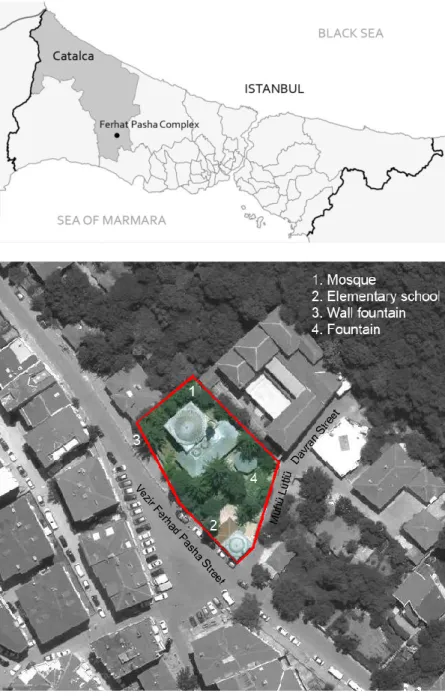
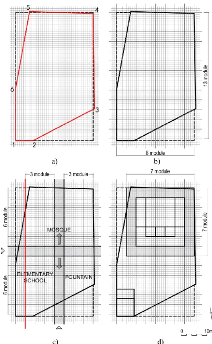
Sinan designed two mosques for a statesman called Ferhat Pasha, who was a vizier during the reigns of Sultan Suleiman I (Suleiman the Magnificent) (1520-1566) and Selim II (1566-1574). One of the mosques was built in Kastamonu during Ferhat Pasha’s lifetime and the other was built in Çatalca, İstanbul (Figure 1) after Pasha's death. The memorial mosque in Çatalca is a part of a complex. The land of the complex is located on a fairly steep slope and has a six-sided irregular polygon form, which was bounded on the east and the south by streets and the north and west by neighboring parcels (Figure 2, 3). The complex, which consists of a mosque, an elementary school, and a public fountain, has hitherto kept its classical view despite two restorations (in the 18th century and between the years 1968 and 1970).
Figure 1. The map of Çatalca, Istanbul (Redrawn from Google map)
Figure 2. Satellite view of the Çatalca Ferhat Pasha Complex (Redrawn from Google map)
olu m e 6, Is su e 1 / Pu bli shed : Jun e 20 18
FIRST STAGE OF PLANNING PROCESS: DEDUCTION
In this stage, the complex was measured and the plans were updated. Based on the analytical studies that were done on the plans, it was seen that the dimensions of its land and the buildings that constitute the complex could be defined by zira, and so the complex was examined by a zira grid system. The public fountain that is a part of the complex was designed independently from this system because it is parallel to the west-angled land wall. Also, the fountain (shadirvan) was not analyzed in this study because it had substantially lost its original identity.
Mosque
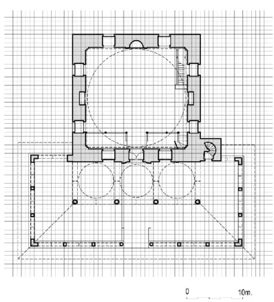
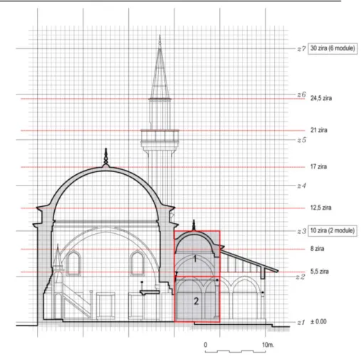
The mosque, which is the main building of the complex, has a single dome and a square plan. Its triple-domed inner portico, which is adjacent to the northern wall of the mosque, is raised on columns with muqarnas capitals. The outer portico, which surrounds the inner portico from three directions, is covered with a slanting wooden roof that is carried on by columns and pilasters with lozenge capitals. The simple prayer hall is symmetrical, with two-tiered windows that are similarly located in four directions. The axis of symmetry is even more emphasized with the gate, mihrab, and niches, which are located between the windows. The 9.00-meter dome is supported by four pendentives rises on a blind octagonal base. A muqarnas-galleried minaret is adjacent to the western wall of the mosque (Figure 3).
The outer dimensions of the prayer hall are 11.40 x 11.40 m, equivalent to 15 x 15 zira. When this square space is divided into 15 equal parts horizontally and vertically, a zira-spaced grid system is obtained. This system defines:
The outer boundary of the prayer halls' walls (15 x 15 zira).
The outer boundary of the inner portico (5 x15 zira). The outer boundary of the outer portico (5 x15 zira; Figure
4).
The spaces that constituted the mosque and the mosque's borders can be described with this system.
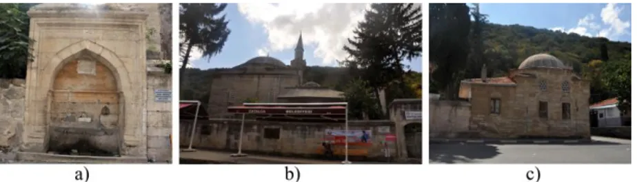
Figure 3.Vezir Ferhad Pasha street view of the Çatalca Ferhad Pasha Complex: a) wall fountain; b) mosque; c) elementary school
IC O N ARP. 20 18 .38 – E -I SSN : 21 47 -9380
The walls are 1½ zira thick, whereas the arches located in the inner and outer porticos are ½ zira thick. According to these measurements, the system that is obtained when we divide the grid system into ½ zira units in the horizontal and vertical planes can define the location and approximate dimensions of the building elements.
Figure 4. Grid system that was created with one zira in the Ferhat Pasha Mosque plan
Figure 5. Grid system that was created with ½ zira in the Ferhat Pasha Mosque plan
olu m e 6, Is su e 1 / Pu bli shed : Jun e 20 18
The grid system created by the ½ zira defines:
Structural elements’ sizes and locations in the mosque (Figure 5). The prayer hall’s outer walls are located in A-D grid spacings, whereas the arches and vertical carriers of the inner and outer porticos are located in a-ı grid spacings, which are ½ zira thick (Figure 6a, b).
Building elements’ (door and window) location and size (door is 2 x 1 ½ zira, windows are 1 ½ x 1 ½ zira; Figure 5).
Approximate boundaries of the base area of the minaret (Figure 5). The minaret cannot be defined only in the southern direction.
Figure 6. Grid system that was created with ½ zira in the Ferhat Pasha Mosque plan: a) A-D grid spacing in prayer hall; b) a-ı grid spacing in the inner and outer porticos
Figure 7.Modular grid system in the Ferhat Pasha Mosque plan
IC O N ARP. 20 18 .38 – E -I SSN : 21 47 -9380
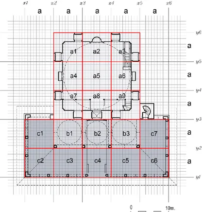
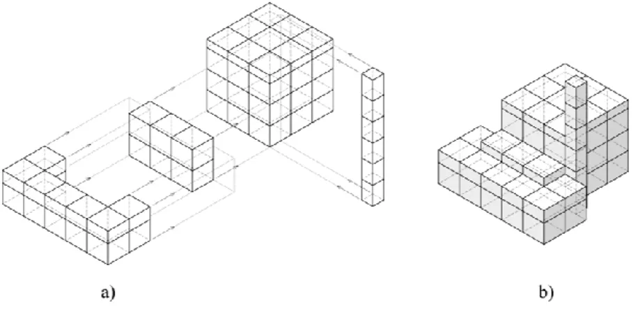
At this stage, the spaces of the mosque can be defined with a 5 x 5 zira grid and its multiples. This size that can describe the whole building is the unit module. Accordingly, the prayer hall was designed in a total of nine modules, such that there are three modules in the horizontal and three in the vertical (a1-a9 in Figure 7). The inner portico, which is the same width as the prayer hall, was designed with expanded one module towards the northern direction from the mosque wall and three modules in the horizontal plane (b1-b3 in Figure 7). Furthermore, the three domes, which are the same size in the inner portico, are located in three separate modules. The outer portico is located in seven modules that surround the inner portico (c1-c3 in Figure 7). According to this system, the prayer hall and porticos were designed in a total of 19 modules.
The modular grid system is also identified for the following sections (Figure 8, 9):
In the prayer hall: the heights of the main dome and arches, inner and outer cornices, altar, gate, and windows. In the inner portico: the heights of the domes, arches, and
columns.
In the outer portico: the heights of the wooden roof eaves, arches, and columns.
In the minaret: the heights of the minaret top, spire, cornice, and balcony (Figure 8).
With the grid system, the size and location of building elements and spaces can be exactly determined in plan and section. Even though the modular system is descriptive for the whole plan, it can only define the height of the inner portico and minaret in section.
Figure 8. a) Module formation scheme of the mosque (prayer hall, inner portico, outer portico, and minaret); b) Module formation scheme of mosque
olu m e 6, Is su e 1 / Pu bli shed : Jun e 20 18 Elementary School
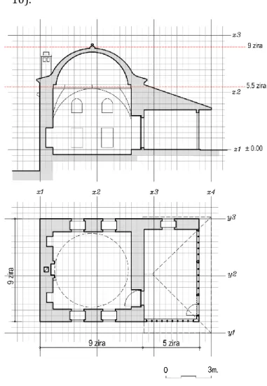
The elementary school is located in the southwest corner of the land (Figure 2, 3) and its north and east sides are in the boundaries of the land. The school has a single dome and a square plan and its portico is covered with a slanting wooden roof, which is carried on three wooden pilasters. The indoor space is symmetrical, with double-tiered windows located on the top and bottom of the east and west walls. The entrance door is in the south. In the middle of the north wall, there is a stove surrounded by two niches on each side. The school has a 5.20-meter dome, which is supported by angular pendentive rises on a blind octagonal base. The western facade of the portico is a continuation of the courtyard wall and has a window (Figure 10).
It is seen that the spaces of the elementary school cannot be identified by the full module; the grid system was decisive in its design. Accordingly, the grid system, in the plan:
Defines the dimensions of the spaces– the outer dimensions of the indoor space is 9 x 9 zira, and for the portico is 5 x 8 zira.
Defines the sizes and locations of structural elements- the thickness of the indoor space walls and western wall of the portico are 1 zira.
Figure 9.Modular grid system in the Ferhat Pasha Mosque section
67
IC O N ARP. 20 18 .38 – E -I SSN : 21 47 -9380
Defines the locations and sizes of building elements (window, door, niche, and stove) - the windows and door are 1 x 1 ½ zira and the closet niches are 1 x ½ zira (Figure 10).
The grid system, in the section:
Defines the outer height of the dome– the indoor space of the elementary school is planned in a 9 x 9 x 9 zira cube. Defines the dome’s arches and the dome’s and portico’s
eaves (Figure 10).
At this stage, there is an association between the mosque size and the land size according to the study done on the location plan of the complex. The distance between the outer boundaries of the mosque's walls and the land border is one module in the south and two modules in the east and west. The modular system does not only determine the boundaries of the mosque, but it also plays a significant role in determining the location of it on the land (Figure 11).
Figure 10.Modular grid system in the Elementary School plan and section
olu m e 6, Is su e 1 / Pu bli shed : Jun e 20 18
SECOND STAGE: PLANNING PROCESS – INDUCTION
When the complex was built, a series of studies should have been made in contrast to the steps of the first stage. The possible steps that may have been followed in these studies made before the construction include:
1. Surveying the land
2. Transferring measured drawings to the grid paper 3. Determination of the module size
4. Design of the complex
Figure 11.Modular grid system in the Ferhat Pasha Mosque site plan
69
IC O N ARP. 20 18 .38 – E -I SSN : 21 47 -9380
The technical preparations start with the selection of the land where the complex will be built. Following this, settlement to the land is the first step of design. As happens today, a sketch showing the topographic condition of the land is drawn. After completing all necessary investigations and drawing the sketches of the land, one proceeds to the design phase. Firstly, the measured drawing of the land should be transferred to squared paper. At this stage, it must be determined in which direction the grid lines will be placed, because that will affect the formation of the whole complex’s design; the positioning obligation in the south-east direction of the mihrab (Qiblah) axis of the mosque is determinant on this decision. Therefore, the grid system's lines have been arranged in such a way that they are perpendicular and parallel to
Figure 12.Modular grid system in the design of the Çatalca Ferhat Pasha Complex: a) transferring measured drawings of the land to the grid system; b) determination of module size; c) determination of the buildings’ positions on the land; d) positioning of the mosque and the elementary school
olu m e 6, Is su e 1 / Pu bli shed : Jun e 20 18
the complex and how these buildings should be positioned on the land will be decided. The mosque is the building that has a leading role in the design; the other buildings in the complex were planned according to the mosque. Therefore, the mosque's size, shape and location should be determined first.
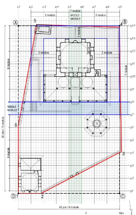
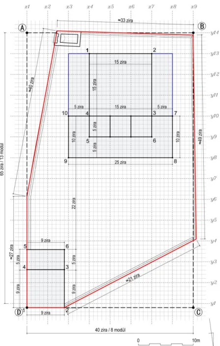
There are many factors that determine/affect mosque design in Ottoman architecture: the patron’s (bani) identity and requests, historical data, location and size of the mosque, boundaries and topographic diversity of its land, relationship between the mosque and the environment, and obligations required by its function (direction on land, forming of the covering elements, etc.). The buildings’ locations will be determined while considering these limitations. The gathering of the community at the entrance of the mosque and the necessary space requirement for the other buildings in the complex caused for the mosque to be positioned in the southern half of the land, while the elementary school and fountain are located in the northern half of the land. After this step, grid paper should be used to identify the relationship between the land and the buildings’ sizes. The fact that the dome is an important symbol in Ottoman architecture has caused its dimensions to be determined according to the patron’s hierarchical significance; accordingly, the maximum size of a vizier mosque's dome is approximately certain4. The dome size of the Çatalca Ferhat Pasha Mosque (9.20 m) should have been determined by trial and error, like today, to be both within these boundaries and be suitable for the land’s dimensions. After the dome size has been approximately decided, the module sizes associated with the land size should be determined.
The six-sided land, defined by the numbers 1-6, is at the same time located in a hypothetical rectangle ABCD. This rectangle, measuring 40 x 65 zira, can be horizontally and vertically divided by five ziras. In this way, modules that are 5 x 5 zira in size are obtained (Figure 11, 12b). In this stage, it must have been decided that the obtained module size was suitable for the desired mosque’s dimensions and the design must have been made according to this system. The module interval, defined by y7 and
y8 lines, is where the complex’s entrance divides the land into two
equal parts in the northeast direction. The mosque is located in the south, whereas the fountain and elementary school are located on the north side of this module (Figure 11, 12c); the mosque's outer portico is adjacent to this module. The mosque is located in the area that is described with the x3, x8 and y8, y13 lines and 5 x 5 module sizes (Figure 11, 12d). The module interval that was
71
Nil Orbeyi IC O N ARP. 20 18 .38 – E -I SSN : 21 47 -9380
defined by the x5 and x6 lines describes the mosque’s entrance axis in the north-south direction; the second entry in this direction of the complex is located in this module interval too. The intersection of these module intervals, which defines the complex’s entrances, emphasizes the mosque’s entrance and center of the land. The elementary school is located on the east and the fountain is located on the west side of this module (Figure 11, 12c). Finally, the structural details of the mosque and elementary school were determined according to the grid system and the design of the complex has been completed.
AFTER PLANNING PROCESS
The modular grid system is decisive not only in the planning process, but also in the processes of estimation report preparation and transferring the project to the land. In Ottoman architecture, after the planning stage, to determine the approximate cost of the building, alternative estimation reports were prepared to give patrons the chance to choose among different designs and costs. The remuneration of the work was determined according to the measure of zira. Accordingly, the material and workmanship could easily be calculated by just counting the squares on the plan, without using any measuring tool, in a project made according to the zira grid system. For example, the thickness of the Ferhat Pasha Mosque’s walls are 1 ½ zira. The zira value of the walls could be calculated simply by counting the squares of the walls in the plan. When the gaps of the door, windows, and niches are removed from this measurement and multiplied by the unit cost, the cost of the construction of the wall could be calculated correctly and quickly. When piece works (such as columns, doors, windows, and mihrab) are added to this calculation, it is possible to obtain a highly reliable estimate in a short time. Because the size of the structure details could be determined in the planning stage, they can be pre-ordered, avoiding possible delays during construction (Necipoğlu, 2005).
After the project chosen by the patron is approved by the sultan, it can be moved into the construction stage. This system also facilitates the transfer of the project to the land. In the working drawing (karname) of Suleymaniye Mosque, the application of the mosque plan was made with the help of stakes and ropes. By the method specified in the source, after the application grid had been marked to the ground, the master could determine the location where it should be and could describe to the bricklayer how to put up the wall in the size specified in the plan in the direction of the application rope. Points in the grid system are certain; therefore, it is not necessary to give another dimension to the bricklayer. At
Sinan vary between 8.20 m and 12.50 m (Necipoğlu, 2005).
olu m e 6, Is su e 1 / Pu bli shed : Jun e 20 18
A similar system must have been used in the Ferhat Pasha Mosque’s design. The hypothetical rectangle ABCD that was formed in the land plan also makes the positioning of the modulation grid on the ground easier. According to this, the AD edge that is parallel with the grid system also overlaps with the east wall that was located in the x1 line. The application grid could be completed easily with width lines that will be marked in parallel and perpendicular to the x1 line.
With the marking of the numbers shown in Figure 10 into this grid through the help of piles, the outer boundaries of the mosque will
Figure 13. The application grid of
the Ferhat Pasha Complex
73
IC O N ARP. 20 18 .38 – E -I SSN : 21 47 -9380
be determined on the ground. The boundaries of the prayer hall are defined by the numbers 1-4, the boundaries of the inner portico are defined by 3-6, and the boundaries of the outer portico are defined by 7-10 (Figure 13).
Similarly, in the elementary school, the indoor boundaries are defined by numbers 1-4 and the boundaries of the portico are defined by 4-6 (Figure 13). After this stage, the construction of buildings, of which their boundaries have been determined on the ground, can be done through simple explanations without any errors.
CONCLUSION
It is still unclear today how the hundreds of works designed by Sinan, which significantly changed the visual culture of the empire’s geography, were mathematically handled, measured, visualized, and projected. This is a major shortcoming in terms of the definability of the architectural language we inherited. This study was conducted to solve this deficiency, specifically for the design process of the Çatalca Ferhat Pasha Complex. As a result of this investigation, it has been determined that building design was made according to a modular grid system, which was created with zira, and the system is determinative for pre-construction preparation processes, such as cost estimation and application. Also, it is thought that the described system is advantageous for the accurate transfer of the project to the land in cases where the designer cannot be found personally. According to this:
The module size is particular to this structure and was determined in the first stage of design and depended on the size of the mosque, which is the main building of the complex, and the land.
The module was used to determine the size of the mosque and its position on the land.
The module is also the identifier for the height of the inner portico and minaret in section.
The grid system is the identifier for the sizes and locations of the building elements, such as walls, arches, and columns, in the mosque and elementary school.
The data obtained from this study are clear enough to leave no room for any doubt. Undoubtedly, the studies which will be done in this direction will ensure that Sinan’s designs are better understood in the future.
olu m e 6, Is su e 1 / Pu bli shed : Jun e 20 18
ten books. (Translated by J. Rykwert et all., 1988). Cambridge, Massachusetts: MIT Press.
Alioğlu, F. and Orbeyi, N. (2011). Mimar Sinan Camilerinde Modüler Sistem. SIGMA Mühendislik ve Fen Bilimleri
Dergisi Özel Sayı, 3(2), 331-40. Retrieved from http://www.ytusigmadergisi.com/pdfs/150.pdf Altan, K. (1936). Eski Mimarların Planları. Arkitekt, 7, 199. Arpat, A. (1986). Numerishcher Symbolismus in der Sakralen
Architectur der Osmanen, II. Uluslararası Türk-İslam Bilim
ve Teknoloji Tarihi Kongresi (April 28 - May 2), İstanbul:
ITU, 2, 67- 80.
Arseven, C. E. (1950). Arşın. Sanat Ansiklopedisi, I, 106-108. İstanbul: Milli Eğitim Basımevi.
Batur, A. and Batur, S. (1968). Sinan bibliyografyası. In C. Bektaş (Ed.), Koca Sinan. Ankara, 79-92.
Cantay, T. (1986). XVI. Yüzyıl Türk Mimarisinde Bazı Tasarım ve Çizim Esasları, II. Uluslararası Türk-İslam Bilim ve
Teknoloji Tarihi Kongresi (April 28 - May 2), İstanbul: ITU,
V. 2, pp. 53-65.
Çamlıbel, N. (2000). Sinan Camilerinde Mekan-Strüktür İlişkisi,
Tasarım Dergisi, 102, 100-106.
Eilouti, B. (2012). Sinan and Palladio: Two Cultures and Nine Squares. International Journal of Architectural Heritage, 6, 1-18, DOI: 10.1080/15583058.2010.495821
Erdem, A. and Özakın, R. (2006). An Analysis of Porched Courtyards in Mosques of the Classical Ottoman Period.
Structural Analysis of Historical Constructions, Possibilities of Numerical and Experimental Techniques, Proceedings of the 5th International Conference SAHC 2006. India,
2051-2059.
Erdenen, O. (1965). Eski Yapılarımızda Plan Meselesi. Mimarlık, 26, 19-23.
Kuban, D. (2007). Osmanlı mimarisi. İstanbul: Yem Yayınları. Kuran, A. (1973). Mimar Sinan Yapısı Karapınar II. Selim
Camisi’nin Proporsiyon Sistemi Üzerine Bir Deneme. VII.
Türk Tarih Kongresi (September 25-29, 1970), Ankara:
Türk Tarih Kurumu, 2, 711-716.
Mülayim, S. (2011). Mimar Sinan bibliyografyası. İstanbul: Marmara Üniversitesi Yayınları.
Necipoğlu, K. G. (1986). Plans and Models in 15th and 16th Century Ottoman Architectural Practice. Journal of the
Society Architectural Historians, 45, 3, 224-243.
Necipoğlu, G. (2005). The age of Sinan, architectural culture in the
Ottoman Empire. Princeton-Oxford: Princeton University
Press.
Orbeyi, N. (2016). Çift Revaklı Sinan Camilerinde Modüler Sistem.
ODTÜ Mimarlık Fakültesi Dergisi, 33, 2, 201-225. DOI:
10.4305/METU.JFA.2016.2.7
Ödekan, A. (1988). Kaynakça. In S. Bayram (Ed.), Mimarbaşı Koca
Sinan Yaşadığı Çağ ve Eserleri I. İstanbul: Vakıflar Genel
Müdürlüğü, 631-640.
75
IC O N ARP. 20 18 .38 – E -I SSN : 21 47 -9380
Palladio, A. (1570). The four books on architecture. (Translated by
R. Tavernor and R. Schofield, 1997). Cambridge: MIT Press.
Sönmez, N. (1999). Mimar Sinan Camilerinde Alt Sıra Pencereleri Boyutlandırma Özellikleri. In Ç. Kafesçioğlu and L. Thyss-Şenocak (Ed.), Aptullah Kuran İçin Yazılar. İstanbul: Yapı Kredi Yayınları, 287-311.
Söylemezoğlu, H. K. (1986). İstanbul Rüstem Paşa Camii (1555-61-70), II. Uluslararası Türk-İslam Bilim ve Teknoloji Tarihi
Kongresi (April 28 - May 2), İstanbul: ITU, 2, 105-114.
Söylemezoğlu, K. (1988). İstanbul Rüstem Paşa Camii Son Cemaat Mahali ve Avlusu Planlamasında Göz Önünde Tutulan Faktörler Hakkında. In Z. Sönmez (Ed.), Mimar Sinan
Dönemi Türk Mimarlığı ve Sanatı. İstanbul: Türkiye İş
Bankası Kültür Yayınları, 259-267.
Tuncer, N. (1999). Azapkapı Sokollu Camisi’nde Oran Araştırması. In Ç. Kafesçioğlu and L Thyss-Şenocak (Eds.), Aptullah
Kuran İçin Yazılar, İstanbul: Yapı Kredi Yayınları, 325-331.
Tuncer, O. C. (2008). Sinan'ın Aynı Planı Uyguladığı Dört Yapıda Izgaralı Düzen. In B. Yediyıldız and K. Tomenendal (Ed.),
Osmanlı'dan Cumhuriyet'e Diyarbakır. Ankara: Diyarbakır
Valiliği ve Türk Kültürünü Araştırma Enstitüsü Yayınları, 485.
Tuncer, O. C. (2010). İstanbul Edirnekapı Mihrimah Sultan Camisi Geometrik Kurgusu, Vakıflar Dergisi, 33, 113-124.
Ünsal, B. (1963). Topkapı Sarayı Arşivinde Bulunan Mimari Planlar Üzerine. Türk Sanat Tarihi Araştırma ve
İncelemeleri, 1, 168-197.
Resume
She received his B.Arch and MSc. in Architecture Department, from Yıldız Technical University, Faculty of Architecture (1997-2004). She earned her PhD. degree in in Building Survey and Restoration Programme from Yildiz Technical University (2010). She is currently working as an Assistant Professor at Mimar Sinan Fine Arts University.