Allochthonous blocks misidenti
fied as the basement: Implication for petroleum
exploration in the SW Thrace Basin (Turkey)
Şamil Şen
a,⁎
, Selin Y
ıllar
a,
İ. Erdal Kerey
b aFaculty of Engineering, Dep. of Geology,İstanbul University, Avcılar, Istanbul, 43320, Turkey bİstanbul Gelişim Educational High School, Avcılar, İstanbul, Turkey
a b s t r a c t
a r t i c l e i n f o
Article history: Received 3 November 2006 Accepted 1 December 2008 Keywords: Allochthonous blocks Thrace Basin Petroleum exploration Northwest Turkey North Anatolian FaultThe sedimentary sequence of the SW Thrace Basin (NW Turkey) comprises of three major sedimentary packages: a) Cretaceous (Meastrichtien)–Early Eocene package formed as pelagic carbonate, turbidite, shelf and nearshore-fluvial deposits, b) Middle Eocene–Early Oligocene package formed as shallow marine, slope apron and turbidite sediments, c) Middle Miocene–Early Pliocene package formed as alluvial fan-fluvial and nearshore deposits. This basin is structurally complex and its southern margin is represented by a fold-thrust zone. The Westward Propagation of the North Anatolian Fault (WPNAF) intersects the Thrace Basin along its southwesternflank. In the SW Thrace Basin, there are ophiolite and limestone blocks in the sedimentary succession, which previously were interpreted as suture of the Intra-Pontide Ocean, Cretaceous aged Yeniköy Mélange or Olistostromal Unit in the Eocene sediments. In this study these rocks have been defined as allochthonous blocks facies of the Gaziköy Formation aged Middle–Late Eocene.
In previous studies the Karaağaç Formation (Early Eocene) was considered to be within oil window and have an average potential for oil and gas generation. According to our data the Karaağaç Formation has a moderate TOC content, is mature and overmature. In the study area, there are potential stratigraphic traps (submarine fans and channels of the Karaağaç and Keşan Formations, fluvial channels of the Fıçıtepe Formation and reefs of the Soğucak Formation), potential fractured tuffs (the Gaziköy Formation) and, potential structural traps related to the folds, thrusts and the WPNAF. Although 17 exploration wells have been drilled in the study area and vicinity, no discovery has yet been made. The cause of this may be that the wells were terminated at depths shallower than potential targets or possibly drilling may have been terminated at the allochthonous block facies of the Gaziköy Formation, which is especially derived from ophiolite mélange and was misidentified as basement.
© 2008 Elsevier B.V. All rights reserved.
1. Introduction
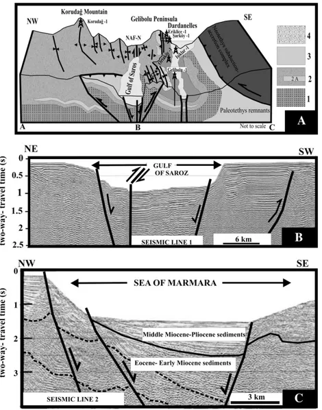
The oil and gas-bearing Thrace Basin (NW Turkey), which extend from Çanakkale in the west to Istanbul in the east, consists of Late Cretaceous to present aged sediments, reaching a maximum thickness over 9000 m (Turgut et al., 1991). The basin is underlain by (1) the Istranca Massif, (2) Istanbul Paleozoic Unit and (3) magmatic arc volcanics to the north and (4) the Paleotethys remnants and (5) Neotethys subduction–accretionary complex to the south (Fig. 1). The Istranca Massif is a metamorphic complex that includes crustal granites of Paleozoic age, metamorphosed sediments of Triassic, Jurassic and intrusive rocks of the Late Cretaceous age (Üşümezsoy,1989; Okay et al., 2001). The Istanbul– Zonguldak Unit is represented by a Paleozoic aged thick sedimentary succession of a passive continental margin (Kaya, 1978; Önalan, 1988) and the magmatic arc is represented by the Late Cretaceous volcanics (Yılmaz et al., 1997). The Paleotethys remnants are composed of pre-Middle Jurassic aged basement rocks (Yılmaz et al.,
1997; Okay and Tüysüz, 1999). The Neotethys subduction–accretion complex consists of the Late Cretaceous aged ophiolite mélange. Sedimentary basin analyses studies suggest that the Thrace Basin has been developed as a transtensional post-collisional basin (Turgut et al., 1991), fore-arc basin (Saner, 1980; Görür and Okay, 1996) or a remnant and post-collisional basin (Tüysüz et al., 1998).
The Westward Propagation of the North Anatolian Fault (WPNAF) crosses the Sea of Marmara and emerges on land at the town of Gaziköy. Between the Sea of Marmara and the Gulf of Saroz, it intersects the SWflank of the Thrace Basin (Şengör, 1979; Sengör et al., 1985; Bargu, 1990; Barka, 1992; Armijo et al., 1999; Okay et al., 2000; Üşümezsoy, 2001; Yaltırak and Alpar, 2002; Seeber et al., 2004; Okay et al., 2004;Şengör et al., 2005;Fig. 1).
The Thrace Basin is the most important productive gas region of Turkey. The Hamitabat, Karacaoğlan, Umurca, Hayrabolu, Kandamış, Bayramşah, Kumrular, Yulaflı, Karaçalı, Tekirdağ, Değirmenköy, Ardıç, Seymen, Vakıflar, Sevindik, Turgutbey, North Marmara and Silivri fields all produce gas, whereas the Deveçatağı, K. Osmancık and Vakiflar fields produce oil (Karahanoglu et al., 1995; Coskun, 1997, 2000; Hoşgörmez and Yalçın, 2005; Gürgey et al., 2005; Huvaz et al.,
⁎ Corresponding author. Tel.: +90 212 4737070; fax: +90 212 4737180. E-mail address:[email protected](Ş. Şen).
0920-4105/$– see front matter © 2008 Elsevier B.V. All rights reserved. doi:10.1016/j.petrol.2008.12.004
Contents lists available atScienceDirect
Journal of Petroleum Science and Engineering
Fig. 1. Simplified regional geology of NW Turkey (modified fromTurgut et al., 1991; Yılmaz et al., 1997; Okay and Tüysüz, 1999; Üşümezsoy, 2001; MTA, 2002; Armijo et al., 2002) and oil and gasfields, dry wells and seismic lines. 1) Istranca Massif, 2) Istanbul Paleozoic sediments, 3) Paleotethys remnants, 4) Upper Cretaceous arc volcanics, 5) Neotethys subduction–accretionary complex, 6) Thrace Basin sediments.
Ş. Şen et al. / Journ al of Petrol eum Science and Engineer ing 64 (20 09) 55 – 66
2005, 2007;Fig. 1). Despite 17 exploration wells, oil and gas has not yet been discovered in the SW Thrace Basin (Fig. 1).
The available surface and subsurface data suggest that the wells in the study area may possibly have been drilled in the allochthonous blocks facies that are mainly derived of ophiolite mélange. Atfirst, the allochthonous blocks facies were interpreted byŞengör and Yılmaz (1981)as Late Cretaceous suture of the Intra-Pontide Ocean and was described by Şentürk and Okay (1984) as Late Cretaceous aged Yeniköy mélange. Later, the allochthonous blocks facies were described byOkay and Tansel (1992)as olistostromal bodies in the Eocene sediments. In this paper, they have been defined as
allochthonous blocks facies of the Gaziköy Formation aged Middle– Late Eocene. The active strike-slip fault of the WPNAF has complicated the geology of the allochthonous blocks facies in the study area.
In this study, two of seismic lines and data from 17 wells have been interpreted. Ages of strata shown in seismic lines have been determined from geological maps, stratigraphy, well logs and well completion reports. In addition,field studies for geological (mapping of formations), structural geological (mapping of structures), sedi-mentary (depositional environments and reservoir architecture analysis) and organic geochemical–paleontological (sample collect-ing) proposes have been carried out. The aim of this study is to
Fig. 2. Generalized stratigraphic succession of the southern Thrace Basin (modified fromSaner, 1985; Önal, 1986a,b; Siyako et al., 1989; Sümengen and ve Terlemez, 1991; Siyako and Huvaz, 2007).
Fig. 3. The geological map of the study area (modified fromÖnal, 1986a; Siyako et al., 1989; Sümengen and ve Terlemez, 1991; MTA, 2002). Ş. Şen et al. / Journ al of Petrol eum Science and Engineer ing 64 (20 09) 55 – 66
investigate the allochthonous blocks facies in the SW Thrace Ba-sin sediments and interpret their significance in the petroleum exploration.
2. Sedimentary features of the SW Thrace Basin
Sedimentary succession comprises three major sedimentary packages:
a) Late Cretaceous–Early Eocene Package: The base of this sedi-mentary sequence is concealed by the Sea of Marmara and the Gulf of Saroz. The lowest part of the package is comprised of basinal pelagic limestone aged Late Cretaceous, termed the Lört Formation (Önal, 1986a). The Lört Formation is unconformably overlain by benthic fossil rich limestone (Başoğlu member), submarine fan sandstone–mudstone and shelf mudstones (Koyunlimanı member ofSaner, 1985 and Siyako et al., 1989; Siyako and Huvaz, 2007) with intrusive rocks such as andesite dykes and sills of the Karaagaç Formation aged the Early Eocene (Saner, 1985; Önal, 1986a; Siyako et al., 1989; Siyako and Huvaz, 2007). This formation is con-formably succeeded by nearshore (Karaburun members ofSaner, 1985, Siyako et al., 1989 and Siyako and Huvaz, 2007) andfluvial mudstones, sandstones and conglomerates of the Fıçıtepe
Forma-tion aged the Early Eocene (Siyako et al., 1989; Sümengen and ve Terlemez, 1991; Siyako and Huvaz, 2007;Figs. 2 and 3).
b) Middle Eocene–Early Oligocene Package: The unconformable base of this package starts with reefoidal limestone of the Soğucak Formation of the Middle–Late Eocene age (Siyako et al., 1989; Sümengen and ve Terlemez, 1991; Siyako and Huvaz, 2007). These are followed by shelf and slope apron deposits represented by marls, slumped shale and thin-bedded sandstones with volcanic rocks assigned to the Gaziköy Formation aged the Middle–Late Eocene (Aksoy, 1987; Sümengen and ve Terlemez, 1991; Yıldız et al., 1997). The Gaziköy Formation also contains allochthonous ophio-lite and limestone blocks of slope apron deposits. The Gaziköy Formation is gradationally succeeded by thick-bedded sandstone and shale of the Keşan Formation aged the Late Eocene, interpreted as proximal and middle submarine fan deposits (Gökçen, 1967; Aksoy, 1987; Sümengen and ve Terlemez, 1991). These formations are gradationally overlain by prodeltaic shale of the Mezardere Formation aged the Early Oligocene (Aksoy, 1987;Figs. 2 and 3). c) Middle Miocene–Early Pliocene Package; This package rests
unconformably on the former packages and begins with the Gazhanedere Formation aged the Middle Miocene represented by alluvial fan-fluvial conglomerates, sandstones and mudstones with a rich fauna of freshwater Ostracods and micro-mammalian remains
Fig. 4. A, The block diagram of the study area along A, B, C line (SeeFig. 3for location); 1) Late Cretaceus–Early Eocene Package, 2) Middle Eocene–Early Oligocene Package, 2A) Allochthonous blocks facies of the Gaziköy Formation,, 3) Middle Miocene–Early Pliocene Package, 4) Late Pliocene–Early Pleistocene rocks, B, Time migrated seismic section along line 1 (seeFig. 2for location, modified fromKurt et al., 2000), C) Time migrated seismic section along line 2 (seeFig. 2for location, modified fromSeeber et al., 2004).
(Kaya, 1989; Tüysüz et al., 1998; Yaltırak and Alpar, 2002). The succeeding Kirazlı Formation aged the Middle–Late Miocene com-prises of fluvio-lacustrine clastics also yielding a rich fauna of freshwater Ostracods and Mammalian fossils. These deposits gradu-ally pass upwards into the brackish-marine clastics and oolitic limestones with abundant Mactra fossils of the Alçıtepe Formation aged the Late Miocene (Kaya, 1989; Tüysüz et al., 1998; Yaltırak and Alpar, 2002). Finally, alluvial fan coarse clastic sediments of the Middle Pliocene–Early Pleistocene age (the Conkbayırı Formation) were deposited (Tüysüz et al., 1998; Okay et al., 1999; Yaltırak et al., 2000; Figs. 2 and 3).
3. Structural features of the SW Thrace Basin
The SW Thrace Basin is highly folded and faulted (Figs. 3 and 4ABC). The Neotethys Ocean subduction–accretion complex has been thrusted over the basement rocks to the south of the basin in Biga Peninsula (Figs. 3 and 4A; MTA, 2002). The WSW–ENE trending Westward Propagation of the North Anatolian Fault (WPNAF) which is a dextral strike-slip fault running from southwest of the West Marmara Sea through to the Gulf of Saroz, has been cut by the SW Thrace Basin deposits. It is responsible for the formation of the Işıklar (Ganos) Mountain and the Gelibolu Peninsula uplifts, the Sea of Marmara and the Gulf of Saroz depressions (Şengör, 1979; Sengör et al., 1985; Bargu, 1990; Barka, 1992; Armijo et al., 1999; Yaltırak et al., 2000; Kurt et al., 2000; Okay et al., 2000; Yaltırak and Alpar, 2002; Seeber et al., 2004; Okay et al., 2004;Şengör et al., 2005;Figs. 1, 3 and 4ABC).
Generally it is accepted that the North Anatolian Fault became active in eastern Anatolia in the Miocene or 13 to 11 Ma (Sengör et al., 1985; Barka, 1992; Hubert-Ferrari et al., 2002;Şengör et al., 2005). However, activity of the Westward Propagation of North Anatolian Fault is questioned. On the one hand,Armijo et al. (1999)suggest that WPNAF became active in 5 Ma,Tüysüz et al. (1998)andYaltırak et al. (2000)offer 3.4 Ma. In addition, according toZattin et al. (2005), the WPNAF follows a preexisting structural discontinuity which was active during late Oligocene (12.5 Ma). On the other hand, according to recent studies byLe Pichon et al. (2001)andŞengör et al. (2005)the Northern Strand of the NAF reached the Sea of Marmara no earlier than 200 ka ago based on 4 km of slip measured in the Sea of Marmara and its correlation with GPS data. GPS data show that NAF-N slip is nearly 20 mm/year.
Besides the activity, offset amounts of WPNAF is also questioned. Armijo et al. (1999)concludes that the two major structures seen on either side of the WPNAF (in Işıklar Mountain and the Gelibolu Peninsula) were anticline features that display comparable sedimen-tary sequences and have been displaced 85 km along the WPNAF. However,Armijo et al. (1999)was criticized byYaltırak et al. (2000) andOkay et al. (2004). According toYaltırak et al. (2000), the Işıklar Mountain is a synclinal structure, with a sedimentary sequence that is significantly different from that exposed in the Gelibolu Peninsula. Okay et al. (2004)concluded that the structure of the Işıklar Mountain is a monoclinal and shortening of the Işıklar Mountain suggests a 40 km offset for WPNAF. However, total offset of the WPNAF in the Sea of Marmara is recently measured as 4 km based on detailed bathymetry, seismic and paleo-seismic studies (Armijo et al., 2002; Le Pichon et al., 2003).
Moreover, both in the southern Gelibolu Peninsula andŞarköy– Gaziköy–Mecidiye areas pre-Middle Miocene rocks have been thrusted (Anafartalar and Mecidiye thrusts) over Middle Miocene– Early Pliocene sediments (Önal, 1986a; Sümengen and ve Terlemez, 1991; Tüysüz et al., 1998; Yaltırak and Alpar, 2002;Figs. 3 and 4AB).
The SW Thrace Basin contains many synclines and anticlines, ranging in length from ones of kilometers to tens of kilometers and most axes are parallel to sub-parallel with each other. In detail, three set of NE–SW trending anticlines (Korudağ, Esendik and Uleman
anticlines) and synclines, which represent an anticlinorium, have been observed in the Korudağ and Işıklardağ (Ganos) Mountains surround-ings (Saner, 1985; Sümengen and ve Terlemez, 1991; Tüysüz et al., 1998; Yaltırak and Alpar, 2002; Figs. 3 and 4AB). The folds were defined in the Korudağ area as Korudağ Anticlinorium by Saner (1985).
According to the mapping in the present study, Işıklardağ Mountain is represented by an anticlinorium (not a single anticline, syncline or monocline) cut by the WPNAF, because recumbent and upright folds mapped byOkay et al. (2004)are represent by sometimes overturned, second and third order folds set of the Korudağ Anticlinorium affected and deformed by WPNAF (Figs. 3 and 4C).
Four set of NE–SW trending anticlines (Fındıklı, Harta, Tırpantepe and Dardanelles anticlines) and synclines have been observed and mapped that they are neither symmetrical nor consistently over-turned in the Gelibolu Peninsula and the Gulf of Saros (Saner, 1985; Önal, 1986a; Sümengen and ve Terlemez, 1991; Tüysüz et al., 1998; Yaltırak and Alpar, 2002;Figs. 3 and 4AB).
4. Petroleum geology of the SW Thrace Basin 4.1. Source rock potential of the SW Thrace Basin
According toBürkan (1992), in the northern and central Thrace Basin, shale of the Hamitabat Formation (equivalent of the Karaagaç Formation) is a gas-prone source rock and the Ceylan Formation (equivalent of the Gaziköy Formation) is a moderate source rock potential for oil and gas generation. However, shales of the Hamitabat and Ceylan Formations are described as gas and limited oil source rock potential by Soylu et al. (1992). The Mezardere Formation is considered as a good oil and gas-prone source rock (Soylu et al., 1992; Bürkan, 1992).
In the SW Thrace Basin,Önal (1986b)andTemel et al. (2005)suggest that due to the 0.47–1% TOC and III–II type organic material content the Karaağaç Formation has moderate oil and gas generation potential. They propose that the Karaağaç Formation is generally within the oil
Table 1
Rock-Eval and TOC data of samples from the Karaağaç Formation (SeeFig. 3for sample locations) Sample no TOC⁎ (wt.%) S1⁎ (mg HC/g sample) S2⁎ (mg HC/g sample) S3⁎ (mg HC/g sample) Tmax⁎ (°C) HI⁎ (mg HC/g org C) OI⁎ (mg CO2/g org C) K1-1 0.49 0.00 0.00 0.37 N/A 0 76 K1-2 0.43 0.00 0.00 0.60 N/A 0 140 K1-3 2.74 0.00 0.09 0.92 585 3 34 K1-4 0.85 0.00 0.01 0.38 520 1 45 K1-5 0.52 0.00 0.00 0.30 N/A 0 58 K1-6 0.05 0.00 0.00 0.16 N/A 0 320 K1-7 0.06 0.00 0.00 0.07 N/A 0 117 K2-1 1.74 0.13 0.23 0.14 488 13 8 K2-2 0.61 0.06 0.44 0.64 537 72 104 K2-3 0.17 0.03 0.06 0.10 486 35 58 K2-4 0.34 0.03 0.07 0.29 529 20 85 K2-5 0.33 0.03 0.04 0.31 520 12 93 K2-6 0.68 0.04 0.08 0.23 519 11 33 K2-7 0.01 0.05 0.15 0.24 581 0 N/A K2-8 0.01 0.03 0.12 0.20 531 N/A N/A K2-9 1.47 0.03 0.06 0.33 539 4 22 K2-10 0.08 0.09 0.97 0.27 591 0 337 K2-11 1.25 0.02 0.55 0.27 444 44 21 K2-12 0.36 0.05 0.13 0.15 484 36 41 K2-13 0.54 0.06 0.14 0.25 515 25 46 K2-14 0.01 0.07 0.1 0.07 482 N/A N/A
⁎TOC = total organic carbon, S1= the amount of volatile organic compounds in the sample, S2= the amount of HC compounds generated from thermal cracking of the koregen, S3 = the amount of CO2from generated the koregen, Tmax = pyrolysis temperature at the maximum rate of kerogen conversion, HI = hydrogen index, 0I = oxygen index.
window. Based on a TOC content of 1.2% referenced byHarput (1998), Coşkun (2000)suggested that the Mezardere Formation in the Gulf of Saros has a good source rock potential.
Analysis of surface samples taken from north of Tayfur village (Fig. 3) indicated that the Karaağaç Formation has moderate source rock potential. Its TOC content ranges from 0.01% to 2.74% with an average 0.63%. However, S2 and HI values are very low, which reflect that most of its HC-generation potential is already converted. Vitrinite reflection (Ro) has not been determined due to inert organic mater content but T-max values between 444 and 591 °C show that the Karaağaç Formation is mature and overmature (Table 1).
The Gaziköy (equivalent of the Ceylan Formation) and Keşan Formations have no source rock potential because TOC contents of 16 surface samples determined in this study are lower than 0.5%. In addition, source rock potential of the Mezardere Formation has not been determined in this study because it has a very restricted distribution in the study area (only located north of the study area (Fig. 3).
Gürgey et al. (2001) reported that the waxy oils from the K. Osmancik and Devecatagi fields were generated from the Eocene Hamitabat Formation (equivalent of the Karaagac Formation) based on oil to source rock correlation. According to gas to source rock correlation (Gürgey et al., 2005) and basin modeling studies (Hoşgörmez and Yalçın, 2005), sediments of the Karaağaç, Ceylan and Mezardere Formations are source to producing gas in the basin.
Basin modeling studies suggest that hydrocarbons were generated in the central part of the basin (Hoşgörmez an Yalçın, 2005; Huvaz et al., 2005, 2007). According to Huvaz et al. (2005, 2007), hydrocarbon generated in the Early Oligocene and expulsion reached a peak in the Early Miocene and subsequently gradually decreased through the Late Miocene due to erosion which uplifted the source rocks above the oil window. Thus, active oil and gas expulsion occurred from 30 to 10 Ma, and charged Early Miocene traps. However, Middle–Late Miocene and Middle Pliocene subsidence has reactivated the petroleum system which is actively generating hydrocarbons. This indicates that the Early Miocene (associated with the Korudag Anticlinorium and Gelibolu folds), and 200 Ka (associated with the WPNAF) traps may be charged. 4.2. Reservoirs, seals and traps of SW Thrace Basin
In the northern and central Thrace Basin, gas in the Hamitabatfield is produced from turbiditic sandstone of the Hamitabat Formation (equivalent of the Karaağaç Formation). Gas of the Karacaoğlan and Kumrular fields have been produced from tuffs of the Ceylan Formation (equivalent of the Gaziköy). Deltaic sandstone of the
Table 2
Summary of the reservoirs in the study area Formation Facies architecture Thickness
(m) Porosity (%) Permeability (mD) References Karaağaç Turbiditic normally graded pebbly sandstone 280 12–15 0.1–10 Sonel and Büyükutku (1998), Büyükutku (2003) Fıçıtepe Nearshore sandstone-fluvial gravel bars and bedforms, sandy bedforms 780 4.47– 19.49 0.16–104 Sonel and Büyükutku (1998), Büyükutku (2003)
Soğucak Boundstone and grainstone/packe-stone
60 10–30 0.1–10 Huvaz et al.
(2005, 2007)
Gaziköy Fractured tuff 160 6–9 0.1–0.2 Büyükutku
(2006) Keşan Turbiditic normally graded pebbly sandstone 650 15–20 1–3 A. Büyükutku, (personal communication)
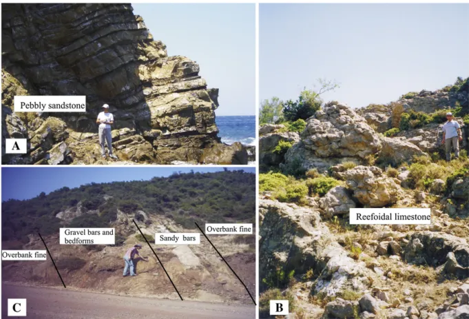
Fig. 5. A, a photograph from Karaağaç Formation (north of Tayfur village), B, a photograph from Fıcıtepe Formation (north of the Tayfur village), C, a photo form Soğucak Formation (Tayfur village).
Osmancık Formation, which is not represented in the study area, is a gas reservoir in the Umurca, Hayrabolu and Kandamış fields. Oil in the Deveçatağı and the North Osmancık fields and gas in the Kuzey Marmara and the Değirmenköy fields have been produced from the reefal limestone of the Soğucak Formation (Fig. 1;Coskun, 1997, 2000; Hoşgörmez and Yalçın, 2005; Gürgey et al., 2005). As seenTable 2, the expected reservoir rocks in SW Thrace Basin are represented by the lower section of the Karaağaç Formation (turbiditic course grained sandstone, Fig. 5A), Fıçıtepe Formation (nearshore and fluvial conglomerate and sandstone,Fig. 5B), the Soğucak Formation (reef-oidal limestone,Fig. 5C), the Gaziköy Formation (fractured tuff levels) and the Keşan Formation (coarse grained turbiditic sandstone.).
In the study area, stratigraphic traps related to reef andfluvial to submarine channels are expected. Reefoidal limestone of Soğucak Formation is covered by mudstones of the Gaziköy Formation. Fluvial pebble and sandstones of the Fıçıtepe Formation and submarine pebbly sandstone of the Karaağaç and Keşan formations are sealed by fluvial flood plain mudstones and basin plain mudstones, respectively. The SW Thrace Basin has also a number of prospect structural traps related to the fold-thrust zone and the Westward Propagation of North Anatolian Fault (WPNAF). They consist of the Korudağ, Beğendik, Uleman, Fındıklı, Harta, Tırpantepe and Dardanelles anticlines Anafartalar –Mecidiye thrusts and normal to strike-slip
fault related to the WPNAF (Figs. 1, 3 and 4ABC). Formation time of the folds (Korudağ Anticlinorium and Gelibolu folds) is thought to be Early Miocene because Eocene–Early Miocene sediments are unconform-ably overlaid by Middle Miocene sediments (Figs. 2 and 4ABC). Formation time of the WPNAF related traps are debated as mentioned above resent studies support the 200 Ka.
5. Allochthonous blocks facies and its implication for petroleum exploration
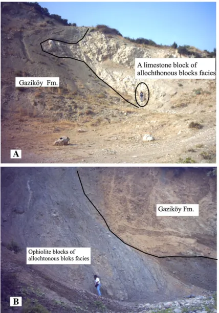
In the SW Thrace Basin, there are outcrops of the ophiolite and limestone blocks in the sedimentary succession around the towns of Gelibolu,Şarköy and Mecidiye. Firstly, ophiolite blocks, which were interpreted as suture of the Intra-Pontide Ocean byŞengör and Yılmaz (1981), were defined as Late Cretaceous aged Yeniköy mélange uplifted by the WPNAF (Şentürk and Okay, 1984). Later, the ophiolite and limestone blocks were described as Olistostromal Unit in the Eocene sediments to the north ofŞarköy byOkay and Tansel (1992). Definition of olistolith in Sci-Tech Dictionary is “An exotic block or other rock mass that has been transported by submarine gravity sliding or slumping and is included in the binder of an olistostrome. Therefore, the Olistostromal Unit has been defined as allochthonous blocks facies in the Gaziköy Formation in this study.Sümengen and ve
Fig. 6. A, a photograph from allochthonous limestone block in the Gaziköy Formation (N ofŞarköy), B, a photograph from allochthonous ophiolite blocks in the Gaziköy Formation (NE ofŞarköy).
Terlemez (1991)described the upper part of the Gaziköy Formation in the vicinity of the town of Gaziköy and the nature of the base of the Gaziköy Formation remained as a gap for further research. We suggest that the basal part of the Gaziköy Formation is located in the Gelibolu Peninsula (Fig. 3) due to sedimentary facies studies and nanoplankton contents, while it was formerly known as the a) Karaağaç member of Burgas Formation (Önal, 1986a), b) Ceylan Formation (Siyako et al., 1989; Siyako and Huvaz, 2007) and c) Burgaz and Korudağ Formation (Sümengen and ve Terlemez, 1991).
Huvaz et al. (2005, 2007)andSiyako and Huvaz (2007)suggest that the Karaağaç Formation is equivalent to the Gaziköy Formation. However, it is clear that the age of the Karaağaç Formation is Lower Eocene (Saner, 1985; Önal, 1986a; Siyako et al., 1989; Sümengen and ve Terlemez, 1991; in this study) and age of the Gaziköy Formation according to fossil content is Middle–Upper Eocene (Aksoy, 1987; Sümengen and ve Terlemez, 1991; Yıldız et al., 1997; in this study). In addition, according to sedimentary facies analysis studies, Karaağaç Formation is regressively followed by nearshore andfluvial sediments of the Fıçıtepe Formation (Saner, 1985; Önal, 1986a; in this study). Unlikely, the Gaziköy Formation is transgresively followed by turbiditic sediments of the Keşan Formation (Aksoy, 1987, in this study). It is interesting to note that an unproven unconformity to the base of the Gaziköy Formation is also offered bySiyako and Huvaz (2007).
Through the measurements in the field, Gaziköy Formation consists of a) mudstone facies, b) interbedded non-graded sandstone and mudstone facies, c) interbedded graded pebbly sandstone and mudstones facies, c) slumped interbedded mudstone and sandstone facies, d) allochthonous blocks facies and e) volcanic rocks. The facies indicated that deposition environments of the Gaziköy Formation are shelf and slope apron.
The basal part of the Gaziköy Formation in the Gelibolu Peninsula and the upper part in the Gaziköy area has the same nanoplanktons such as Sphonolithus obtucus (BUKRY), Cyclicargolithusfloridanus (ROTH and HAY), Coccolithus pelagicus (BRAMLETTE and RIEDEL) and Dictyococcites bisectus (HAY, MOHLER and WADE). The fossil contents indicate that the age of the Gaziköy Formation is Middle–Late Eocene. Similarly, fossil determinations byAksoy (1987),Sümengen and ve Terlemez (1991)andYıldız et al. (1997)also suggests that age of the Gaziköy Formation is Middle–Late Eocene. However, Siyako and Huvaz (2007) suggest that age of the Gaziköy Formation is Early Eocene based on stratigraphical correlation within the basin.
The allochthonous blocks facies of the Gaziköy Formation are composed of blocks of serpantinite, metadiabase, diorite, gabbro, radiolarian chert, quartzite, recrystallised limestone, Late Cretaceous– Paleocene pelagic limestone and Middle Eocene reefoidal limestone.
The provenance of most of the blocks is the Neotethys subduction– accretion complex, which is located south of the basin (Figs. 1 and 3). The thickness of the facies is 520 m (Fig. 3). These deposits display a sharp contact with turbitidic interbed sandstone and mudstone of the Gaziköy Formation (Figs. 6AB, 7 and 8). The blocks are generally sub-angular, and range in size from mega blocks (such as hundreds of meters) to blocks (tens of centimeters). The blocks have a chaotic internal fabric and lack any evidence of grading. They are known as deposits of debrisflow in the slope apron (Mullins and Cook, 1986; Lomas, 1999).
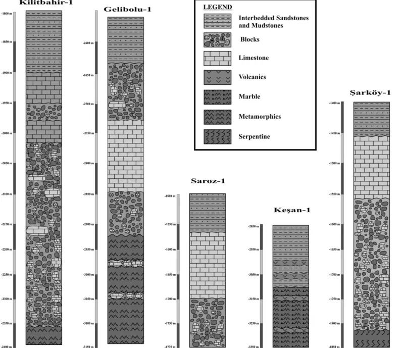
Seventeen exploration wells have been drilled in the study area (Fig. 1). Doluca-1 well cut the Gazhanedere and Kirazlı Formations and was terminated in the allochthonous blocks facies of the Gaziköy Formation. According to Hoşköy-1, Çınarlı-1, Mürefte-1, Tepeköy-1, Eriklice-1, Şarköy-1, Işıklar-1, Ortaköy-1 and Saroz-1 wells, allochthonous blocks facies is covered by the Gazhanedere, Kirazlı and Gaziköy Formations. Similarly, the Kilitbahir-1, Gelibolu-1 and Kumtepe-1 wells were drilled through the Alçıtepe, Kirazlı, Gazhanedere, Keşan and Gaziköy Forma-tions and they were also terminated in the allochthonous blocks facies (Fig. 7). In addition, allochthonous blocks were covered by the Mezardere, Keşan and Gaziköy Formations in the Keşan-1 well. The detailed logs of the allochthonous blocks facies in the wells are shown inFig. 8.
The primary cause of both the outcrops in the surface area around the towns of Gelibolu,Şarköy and Mecidiye and different depth in the wells of the allochthonous blocks facies is due to the fold-thrust zone and effects of the WPNAF. The WPNAF cut the SW Thrace Basin and complicated the sedimentary succession (Figs. 3 and 4ABC). Therefore, all wells were terminated in the allochthonous blocks facies of the Gaziköy Formation and the Soğucak, Fıçıtepe and Karaağaç Forma-tions could not be tested deeper in these wells. Unfortunately, all wells in the area were drilled before olistrostral unit has been described by Okay and Tansel (1992).
The SW Thrace Basin has a number folds and thrusts (Figs. 3 and 4ABC). Although two of these structures were tested with the Ulaman-1 (drilled in Ulaman-196Ulaman-1) and Korudağ-1 (drilled in 1965) wells, both were terminated in Gaziköy Formation at 2351 m and 1718 m depths before reaching the Soğucak Fıcıtepe and Karaağaç Formations due to technological restrictions. Similarly, the İpsila-1 well (drilled in 1988) was terminated at 2375 m in the Gaziköy Formation (Fig. 7). Thus, deeper wells might be drilled in order to test reservoir potential of the Soğucak, Fıçıtepe and Karaağaç Formations in the study area. In addition, the Gelibolu-1, Ortaköy-1 andŞarköy-1 wells were interest-ingly, drilled in the Gelibolu Syncline (Figs. 3 and 4AB), because the wells were possibly targeted stratigraphical trap of the reefodial limestone blocks.
Fig. 8. Detailed logs of the allochthonous blocks in the exploration wells in the study area. Ş. Şen et al. / Journ al of Petrol eum Science and Engineer ing 64 (20 09) 55 – 66
It is important to note that misidentified as the basement of the allochthonous blocks have also affected to the basin sediment thickness. Therefore, thickness map (Turgut et al., 1991), burial history, thermal gradient history and drainage areas of the SW Thrace Basin are miscalculated (Huvaz et al., 2005, 2007; Hoşgörmez and Yalcın, 2005).
6. Conclusions
The sedimentaryfill of the Thrace Basin comprises of three major sedimentary packages: (a) a Late Cretaceous–Early Eocene Package; (b) a Middle Eocene–Early Oligocene Package; (c) a Middle Miocene– Early Pliocene Package. Sediments of the Karaağaç Formation aged Early Eocene have oil and gas generation potential according toÖnal (1986b)and Temel et al. (2005). Our studies showed also that the Karaağaç Formation has moderate source rock potential. However, S2 and HI values are very low, which reflect that most of its HC-generation potential is already converted. The Karaağaç, Fıcıtepe, Soğucak, Gaziköy and Keşan Formations have a reservoir potential. Trap opportunity is as vast as stratigraphic traps of reefs (Soğucak Formation) and channels (Karaağaç, Fıçıtepe and Keşan Formations) and the structural traps of folds, thrusts and WPNAF.
Although 17 exploration wells have been drilled, so far no oil and gas has been discovered. The cause of unsuccessful explorations is most probably due to the fact that wells were terminated at shallower depths than prospects or that possibly the wells were terminated in the allochthonous block facies of the Gaziköy Formation, which is especially derived from mélange and misidentified as basement. All of the data collected in the current study suggests that the additional source rock analyses and the deeper wells to test the potential Soğucak, Fıçıtepe and Kaaraağaç Formation reservoirs along fold-thrust zone and WPNAF, are required. The depths of the prospects are expected to range from 2000 m to 5500 m depending on the erosion (Figs. 2–4ABC).
Acknowledgement
This work was supported by the Research Fund of theİstanbul University (Project numbers 1773/21122001, T-438/08032004 and BYP-1107), and Turkish Petroleum Corporation (TPAO). We thank Şener Üşümezsoy, M. Namık Yalçın, Hakan Hoşgörmez (Istanbul University), Gilbert Kelling (Keele University), Dr. Sezgin Aytuna (Aytuna Consulting), Aynur Büyükutku (Ankara University), Mete Gürel, Zihni Aksoy, Hasan Emiroğlu and Attila Özatar (Turkish Petroleum Company) for their helpful and constructive comments and Ayşegül Yıldız (Nigde University) for nannoplankton fossil determination.
References
Aksoy, M.Z., 1987. Barboros-Keşan-Kadìköy-Gaziköy (Güney Trakya) arasındaki birimlerin depolanma ortamları, Türkiye 7. Petrol Kongresi Bildirileri, Ankara, s, pp. 292–311.
Armijo, R., Meyer, B., Hubert, A., Barka, A., 1999. Westward propagation of the North Anatolian fault into the northern Aegean: timing and kinematics. Geology 27, 267–270.
Armijo, R., Meyer, B., Navarro, S., King, G., 2002. Slip partitioning in the Sea of Marmara pullapart: a clue to propagation processes of the North Anatolian Fault. Terra Nova 14, 80–86.
Bargu, S., 1990. Kuzey Anadolu Fayı'nın Gaziköy ve Mürefte (Tekirdağ) dolayında yapısal özellikleri ve hareket mekanizması. İst. Üniv. Müh. Fak. Yerbilimleri Derg., vol. 6, (1–2), pp. 77–97.
Barka, A., 1992. The North Anatolian fault zone. Ann. Tecton. 6, 164–195.
Bürkan, K., 1992. Geochemical evaluation of the Thrace basin. Proceedings, 9th Petroleum Congress of Turkey, pp. 34–48.
Büyükutku, A.G., 2003. The diagenesis of Middle Eocene sandstones from Western Thrace basin Turkey. J. Geol. Soc. India 62, 83–90.
Büyükutku, A.G., 2006. Diagenesis of Upper Eocene volcaniclastic rocks and its relevance to hydrocarbon exploration in the Thrace Basin, Turkey. Energy Sources, Part A 28, 1039–1049.
Coskun, B., 1997. Oil and gasfields-transfer zone relationships, Thrace basin, NW Turkey. Mar. Pet. Geol. 14, 401–416.
Coşkun, B., 2000. North Anatolian Fault-Saroz Gulf relationship and their relevance to hydrocarbon exploration, North Aegean Sea Turkey. Mar. Pet. Geol. 17, 751–772. Gökçen, S.L., 1967. Keşan bölgesinde Eosen-Oligosen sedimantasyonu, Güneybatı
Türkiye Trakyası, Maden Tetkik ve Arama Enst. Derg., vol. 69, pp. 1–10. Görür, N., Okay, A.I., 1996. A fore-arc origin for the Thrace Basin, NW Turkey.
Geologische Rundschau 85, 662–668.
Gürgey, K., Philp, R.P., Emiroglu, H., Siyako, M., Uygur, E., Isik, T., 2001. Stable carbon isotope variation of bulk and individual n-alkanes in crude oils and associated condensates from Thrace Basin, Turkey. 13th International Petroleum Congress and Exhibition of Turkey, Abstract, p. 97.
Gürgey, K., Philp, R.P., Clayton, C., Emiroğlu, H., Siyako, H., 2005. Geochemical and isotopic approach to maturity/source/mixing estimations for natural gas and associated condensates in the Thrace Basin, NW Turkey. Appl. Geochem. 20, 2017–2037.
Harput, B., 1998. Comparision of maturity profiles of different basin in Turkey. Proceedings of 12th Turkish Petroleum Congress, Abstract, p. 380.
Hoşgörmez, H., Yalçın, M.N., 2005. Gas-source rock correlation in Thrace basin, Turkey. Mar. Pet. Geol. 22, 901–916.
Hubert-Ferrari, A., Armijo, R., King, G., Meyer, B., Barka, A., 2002. Morphology, displacement, and slip rates along the North Anatolian Fault, Turkey. J. Geophys. Res. 107 (art. no. 2235).
Huvaz, O., Sarıkaya, H., Nohut, O.M., 2005. Nature of a regional dogleg pattern in maturity profiles of the Thrace Basin, northwestern Turkey: a newly discovered unconformity or a thermal anomaly? AAPG Bull. 89 (10), 1373–1396.
Huvaz, O., Karahanoğlu, N., Ediger, V., 2007. The thermal gradient history of the Thrace Basın, NW Turkey: correlation with basin evolution processes. J. Pet. Geol. 30 (1), 3–24.
Karahanoglu, N., Erler, A., Illieez, H.I., 1995. Mathematical approach to hydrocarbon generation history and source-rock potential in the Thrace basin. Mar. Pet. Geol. 12, 587–596.
Kaya, O., 1978.İstanbul Ordovisiyen ve Silirüyeni: Hacettepe Yerbilimleri Der., vol. 4, pp. 1–22.
Kaya, O., 1989. Alcıtepe (Gelibolu Yarımadası) yöresi memeli faunaları, Perissodactyla bulguları. Türk. Jeol. Bül. 32 (1–2), 79–88.
Kurt, H., Demirbağ, E., Kuşcu, I., 2000. Active submarine tectonism and formation of the Gulf of Saroz, Northeast Aegean Sea, inferred from multi-channel seismic reflection data. Mar. Geol. 165, 13–26.
Le Pichon, X.,Şengör, A.M.C., Demirbağ, E., Rangin, C., İmren, C., et al., 2001. The active Main Marmara Fault. Earth Planet. Sci. Lett. 192, 595–616.
Le Pichon, X., Chamot-Rooke, N., Rangin, C.,Şengör, A.M.C., 2003. The North Anatolian Fault in the Sea of Marmara. J. Geophys. Res. 108 (B4), 2179.
Lomas, S.A., 1999. A Lower Cretaceous clastic slope succession, Livingstone Island, Antarctica: sand-body characteristics, depositional processes and implications for slope apron depositional models. Sedimentology 46, 477–504.
MTA, 2002. Türkiye jeoloji haritası: Maden Tetkik ve Arama Enstitüsü, ölçek 1:500.000 Ankara.
Mullins, H.T., Cook, H.E., 1986. Carbonate apron models: alternatives to submarine fan model for palaeoenvironmental analysis and hydrocarbon exploration. Sediment. Geol. 48, 37–79.
Okay, I.A., Tansel, I., 1992. New data on the upper age of the Intra-Pontide Ocean from north ofŞarköy (Thrace) MTA Dergisi, vol. 114, pp. 23–26.
Okay, A.I., Tüysüz, O., 1999. Tethyan sutures of northern Turkey. In: Durand, B., Jolivet, L., Horvath, F., Seranne, M. (Eds.), Mediterranean Basins: Tertiary extension within the Alpine Orogen: Geological Society London. Special Pub., vol. 156, pp. 475–515. Okay, A.I., Demirbag, E., Kurt, H., Okay, N., Kuşçu, I., 1999. An active, deep marine
strike-slip basin along the North Anatolian fault in Turkey. Tectonics 18, 129–148. Okay, A.I., Kaslilar-Ozcan, A., Imren, C., Boztepe-Guney, A., Demirbag, E., Kuscu, I., 2000.
Active faults and evolving strike-slip basins in the Marmara Sea, northwest Turkey: a multichannel seismic reflection study. Tectonophysics 321, 189–218.
Okay, I.A., Satır, M., Tüysüz, O., Akyüz, S., Chen, F., 2001. The tectonics of the Strandja Massif: late Variscan and mid-Mesozoic deformation and metamorphism in the north Aegean. Int. J. Earth Sci. 90, 217–233.
Okay, A.I., Tuysüz, O., Kaya,Ş., 2004. From transpression to transtension: changes in morphology and structure around a bend on the North Anatolian Fault in the Marmara region. Tectonophysics 391, 259–282.
Önal, M., 1986a. Gelibolu Yarımadası orta bölümünün çökelme ortamları ve tektoniği, KB Anadolu, Türkiye,İst. Üniv. Yerbilimleri Dergisi c.5, no.1–2, s., pp. 21–38. Önal, M., 1986b. Gelibolu Yarımadası'ndaki iki ana kayanın organik jeokimyası ve kil
mineralleri ile incelenmesi. Türkiye Jeoloji Kurumu Büteni, vol. 29, pp. 97–104. Önalan, M., 1988.İstanbul Devoniyen çökelerinin sedimenter özellikleri, İ.Ü.
Yerbilim-leri Dergisi, c. 6, ss., pp. 92–105.
Saner, S., 1980. Batı Pontidlerin ve komşu havzaların oluşumlarının levha tektoniği kuramı ile açıklanması, KB Türkiye. MTA Dergisi 93/94, 1–19.
Saner, S., 1985. Saroz Körfezi dolayının çökelme istifleri ve tektonik yerleşimi, Kuzeydoğu Ege Denizi, Türkiye: TJK. Bülteni 28, 1–10.
Seeber, L., Emre, O., Cormier, M.-H., Sorlien, C.C., McHugh, C.M.G., Polonia, A., Ozer, N., Cagatay, N., 2004. Uplift and subsidence from oblique slip: the Ganos–Marmara bend of the North Anatolian Transform, Western Turkey. Tectonophysics 391, 239–258. Şengör, A.M.C., 1979. North Anatolian transform fault: its age, ofset and tectonic
significance. J. Geol. Soc. 136, 269–282.
Şengör, A.M.C., Yılmaz, Y., 1981. Tethyan evolution of Turkey: a plate tectonic approach. Tectonophysics 75, 181–241.
Sengör, A.M.C., Görür, N., Saroglu, F., 1985. Strike-slip faulting and related basin formation in zones of tectonic escape: Turkey as a case study. In: Biddle, K.T.,
Christie-Blick, N. (Eds.), Strike-Slip Faulting and Basin formation. Soc. Econ. Paleontol. Mineral. Spec. Publ., vol. 37, pp. 227–264.
Şengör, A.M.C., Tüysüz, O., İmren, C., Sakınç, M., Görür, N., Le Pichon, X., and Rangin, C., 2005. The North Anatolian Fault: Anew Look, Annual Review of Earth and Planetary Sciences 2004. 33:1–75.
Şentürk, K., Okay, A.I., 1984. Saroz Körfezi doğusunda yüksek basınç metamorfizması. MTA Derg. 97/98, 151–155.
Siyako, M., Huvaz, O., 2007. Eocene stratigraphic evolution of the Thrace Basin, Turkey. Sediment. Geol. 198, 75–91.
Siyako, M., Bürkan, K.A., Okay, A.I., 1989. Biga ve Gelibolu Yarımadaları'nın Tersiyer jeolojisi ve hidrokarbon olanakları. TPJD Bül. 1 (3), 183–199.
Sonel, N., Büyükutku, A.G., 1998. Trakya Havzası kuzeyi Orta-üst Eosen yaşlı kumtaşlarının hazne kaya özellikleri. MTA Derg. 120, 259–268.
Soylu, C., Harput, B., Illeez, H.I., Ertürk, O., Iztan, H., Uğur, F.A., Göker, T., Harput, A., Gürgey, K., Sayılı, S., 1992. Organic geochemical evaluation of the northern Thrace basin. Proceedings, 9th Petroleum Congress of Turkey, Turkey, pp. 49–61. Sümengen, M., ve Terlemez, I., 1991. Güneybatı Trakya yöresi Eosen çökelleri
stratigrafisi. MTA Derg. 113, 17–30.
Temel, R.Ö., Çiftçi, N.B., Siyako, M., 2005. Petroleum geology of the region surrounding the Gulf of Saroz, NW Turkey. 15 International Petroleum and Natural Gas Congress and Exhibition of Turkey, p. 15.
Turgut, S., Türkaslan, M., Perinçek, D., 1991. Evolution of the Thrace sedimentary basin and its hydrocarbon prospectivity. In: Spencer, A.M. (Ed.), Generation, Accumula-tion, and production of Europe's Hydrocarbons. Spec. Publ. Eur. Assoc. Petrol. Geosci., vol. 1., pp. 415–437.
Tüysüz, O., Barka, A., Yiğitbaş, E., 1998. Geology of the Saroz graben and its implication for the evolution of the North Anatolian Fault in the Ganos–Saroz region. Tectonophysics 293, 105–126.
Üşümezsoy, Ş., 1989. Istranca batholit and associed porhyry type mineralization. Geosound 17, 59–101.
Üşümezsoy, Ş., 2001. 17 Ağustos sonrası Marmara'da Deprem Riski, Inkılap Kitapevi. 365s.
Yaltırak, C., Alpar, B., 2002. Kinematics and evolution of the northern branch of the North Anatolian fault (Ganos fault) between the Sea of Marmara and the Gulf of Saroz. Mar. Geol. 190, 307–327.
Yaltırak, C., Sakınc, M., ve Oktay, F.Y., 2000. Westward propagation of the North Anatolian fault into the northern Aegean: timing and kinematics, Comment. Geology 28, 187–188.
Yıldız, A., Toker, V., Şengüler, İ., 1997. Trakya Havzası Güneyi, Orta Eosen–Oligosen birimlerinin Nannoplakton biyostratigrafisi ve deniz yüzey suyu ısı değişimi. TPJD Bül. 9 (1), 31–44.
Yılmaz, Y., Tüysüz, O., Yiğitbaş, E., Genç, Ş.C., ve Şengör, A.M.C., 1997. Geology and tectonic evolution of the Pontides. in A.G. Robinson eds., Regional and petroleum geology of the Black Sea and surrounding region. AAPG Mem. 68, 138–226. Zattin, M., Okay, A.I., Cavazza, W., 2005. Fission-track evidence for late Oligocene and
mid-Miocene activity along the North Anatolian Fault in south-western Thrace. Terra Nova 17 (2), 95–101.