Determınatıon Of Local Quası-Geoıd In Central Anatolıa For Engıneerıng And Gıs Purposes
Tam metin
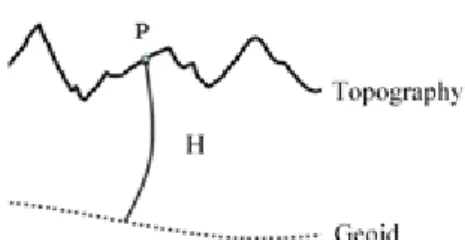
Şekil


Benzer Belgeler
The autonomy of the female self in late 19 th century and freedom from marriage are some of the themes that will be discussed in class in relation to the story.. Students will
Students will be asked to report their observations and results within the scope of the application to the test report immediately given to them at the end of
The other tourism villages and tourism destinations in Northern Cyprus might resist to development plans for a new tourist destination due to possible competition,. Market
The previous term was more likely the introductory features of the organic chemistry more likely related to preperation of students for the “Drug World” as
A CdZnTe based semiconductor X-ray detector (XRD) and its associated readout electronics has been developed by the Space Systems Design and Testing Laboratory of Istanbul
But for = 1; Mo- nopolist’s pro…t under duopoly is higher than the Monopolist’s pro…t under monopoly if 45 2 b 2 < 92 b 2 48 4 :If the motivation cost e¢ ciency ( 1 ) or
Since there will be multiple plants and multiple users, there will be multiple task and feedback objects at the same time in the system. In order to send the task and feedback
Our institution, changed from Koşuyolu Hospital of Asthma to Koşuyolu Cardiology and Research Hospital by Kemal Beyazit, MD on February 1985, has trained hundreds of cardiologists,
