1. INTRODUCTION
Calciturbidites occur in various sedimentary environments such as continental slopes, toe of slope and single or multiple feeding submarine fans (WATTS, 1987; RUBERT et al., 2012; HAIRA BIAN et al., 2015). They can also be associated with different parts of carbonate platforms and platform margins (REIJMER et al., 2015a, 2015b). The most important characteristic that distin guishes calciturbidites from siliciclastic deposits of the deep sea are the unique diagenetic process of dolomitization, silicification (chert layers or lenses) and micritization (EBERLI, 1991; RU BERT et al., 2012; GÜL, 2015). Calciturbidites are generally characterized by poor sorting, local inverse grading, diagenetic micritic layers embedded in the base and nodular silica layering (EBERLI, 1991). Chertification due to diagenesis affects the po rosity and permeability of the host rocks (McBRIDE et al., 1999; SALLER et al., 2001; BEHL, 2011). The sedimentation in carbo nate gravity systems is controlled by sea level fluctuations, source region, regional basin tectonics and slope characteristics (e.g., EBERLI, 1991; PAYROS & PUJALTE, 2008). REIJMER et al. (2015a) emphasized that calciturbidites are of interest to the oil and gas industry because of their porous and permeable granular structure.
Although studies have shown calciturbidites to crop out in various regions with different ages, fewer studies have been car ried out on the calciturbidites in comparison to siliciclastic turbi dites. The calciturbidites of the Babadağ Formation (in this manu script), are similar to the calciturbidites from the Southern
Lithostratigraphy and Sedimentological Characteristics
of the Calciturbidites of the Babadağ Formation-Tavas Nappe
(SW Turkey)
Basiru Mohammed Kore1, Murat Gül1,*, Ceren Küçükuysal1 and Bilal Sarı2
1 Muğla Sıtkı Koçman University, Faculty of Engineering, Department of Geological Engineering, 48000, Muğla, Turkey;
(princebmKORE,@yahoo.com; cerenkucukuysal@mu.edu.tr; *corresponding author: muratgul@mu.edu.tr; muratgul.geol@gmail.com)
2 Tınaztepe Campus, Dokuz Eylül University,Faculty of Engineering, Department of Geological Engineering, 35160, Buca-İzmir, Turkey; (bilal.sari@deu.edu.tr)
doi: 10.4154/gc.2021.01
Abstract
The Lycian Nappes contain slices of ophiolites and sedimentary rocks of various ages that crop out in SW Turkey. They evolved and were emplaced under the effect of the Late Cretaceous-Miocene compressional regime. The Tavas Nappe is part of the Lycian Nappes and contains Jurassic-Eocene sediments. The Babadağ Formation, forming the middle part of the Tavas Nappe, is composed of limestone at the base and various sized calciturbidites with chert inter-calations in the upper part. The Standard Microfacies Classification (SMF of FLÜGEL, 2004) indicates that the entire unit was deposited mainly in a deep-shelf environment (Facies Zone – FZ-2), deep-sea (FZ-1), toe of slope (FZ-3) and on the continental slope (FZ-4). Calcite and quartz dominate the bulk mineralogy of the calciturbidites with higher SiO2 and CaO weight percenta-ges than other major oxides. Additionally, the presence of Na2O, K2O, Al2O3, MgO, TiO2 and Fe2O3 is associated with the local sediment input. Tectonism and sea level fluctuations were the main triggering factors of the changes in the original depositional environment of the Babadağ Formation. Additionally, grain size and the amount of sediment input control the calciturbidite type and extension. Si enriched water circulation and Si and Ca substitution were responsible for the abundant chert formation during diagenesis of the units. Post depositional tectonic ac-tivities during transportation and emplacement of the nappes resulted in calcite filled cracks that cut both the calciturbidites and cherts. Study of the different nappe slices provides valuable in-formation about syn- and post- depositional changes of the lithostratigraphic units.
Provence Basin, TuronianCenomanian, France (REIJMER et al., 2008, 2012; REIJMER et al., 2015a, 2015b); the Late Triassic Early Jurassic of Northern Hungary (HAAS et al., 2010); Jurassic Tethys Oceanic Carbonate deposits of Eastern AlpsSwitzerland (EBERLI, 1987); the Early Cretaceous of the Manim unit, West ern Carpathians Slovakia (MICHALIK et al., 2012); the Late Cretaceous of the Ionian BasinCentral Albania (DEWEVER et al., 2007) and the Cretaceous of the Othris MountainHellenide zone and Eastern Greece (PRICE, 1977). Some older calciturbi dites were reported in different countries; the SilurianDevonian calciturbidites of the Barrandian RegionCzech Republic, (VA CEK, 2007); the EarlyMiddle Triassic Sumeini Group, Maqam Formation, northernmost Arabian Carbonate Platform (WATTS, 1987); and the Triassic Pedata / Potschen Formation calciturbi ditesAustria (REIJMER et al., 1991).
In Turkey, ROBERTSON & WOODCOCK (1981) docu mented the Upper Triassic calcareous clastics and the Jurassic Lower Cretaceous siltstoneradiospherechertmudstonelime stones and black shales in AntalyaSW Turkey. SOFRACIOĞLU & KANDEMİR (2013) and SARI et al. (2014) reported the Upper Mesozoic calciturbidites in the Eastern PontidesNE Turkey. ÖZCAN et al. (2012) mentioned the Upper CretaceousEocene pelagic micrites and calciturbidites of the Black Sea shoreline and the Western Pontides–N Turkey. SOLAK et al. (2015) docu mented some Upper Cretaceous calciturbidites in the Bornova Flysch Zone in the ManisaSpil Mountain–W Turkey (Fig. 1).
Article history:
Manuscript received December 19, 2019 Revised manuscript accepted October 14, 2020 Available online February 28, 2021
Keywords: Facies Zone – Standard Microfacies (FZ – SMF, FLÜGEL, 2004), Deep-Sea, Lycian Nappes, Muğla-SW Turkey.
Geologia Cr
oatica
Geologia Croatica 74/1
2
upper part of the Babadağ Formation require additional studies for a complete understanding of the carbonate gravityflow de posits.
Therefore, this study aims (1) to determine the detailed sedi mentological characteristics of the calciturbidites of the Babadağ Formation mapped as separated slices which together comprise the Tavas Nappe (Fig. 2), and (2) to unravel the depositional environment and controlling factors on the calciturbidite sedi ments.
2. GEOLOGICAL SETTING
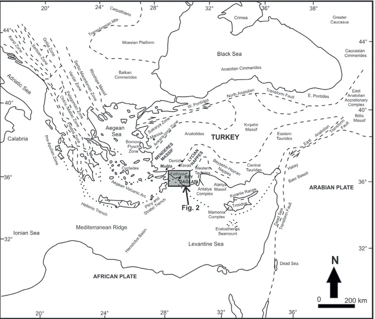
SW Turkey contains three major geological units; the Beydağları Autochthone, the southern Menderes Massif and the Lycian Nap pes allochthones which crop out between these two autochthones (Fig. 1).
The Beydağları Autochthone includes Late TriassicCreta ceous platform carbonates and the LutetianMiocene sediments (Fig. 3; ERSOY, 1990; ŞENEL et al., 1989, 1994, 1998; SARI & ÖZER, 2001; 2002; SARI et al., 2004; SARI, 2006; 2017; ŞENEL, 2004, 2007; SOYCAN et al., 2015). The core of the southern part of the Menderes Massif contains gneiss and metagabbro at the core; the cover part includes Upper DevonianEarly Eocene am The Lycian Nappes are sandwiched between the Beydağları
Autochthone to the south and the Menderes Massif to the north in the TaurideAnatolide Platform of Turkey (Fig. 1). They are mainly composed of allochthons with remnants of oceanic crust that encompass diverse deepwater and platform type deposits (DANELIAN et al., 2006; GÖNCÜOĞLU, 2011; MOIX et al., 2013; SARI, 2017). The Lycian Nappes (including deepwater sediments of the Tavas Nappe), have since become a subject of widespread interest for numerous researchers over the last four decades, focusing on the fossil content and local lithological chara cteristic of the units (YILMAZ, 1981; ERAKMAN et al., 1982; ŞENGÖR et al., 1984; OKAY, 1989; ŞENEL et al., 1994; KO ZUR, 1998; COLLINS & ROBERTSON, 1998, 1999; ÖZCAN et al., 2012; GÜL et al., 2013; GÜL, 2015; SOYCAN et al., 2015; SARI, 2017). However, determination of the differences of nappe slices, which are thought to be the product of the same environ ment and when separated are mapped under the same nappe name, can provide valuable information about the primaryorigi nal depositional environment. This depositional environment can be quite large. As a result, the lithologicalcompositional texturalstructural differences detected in each nappe slice can help identify the characteristics of the depositional environment both syn and post sedimentation. Thus, calciturbidites in the
Geologia Cr
oatica
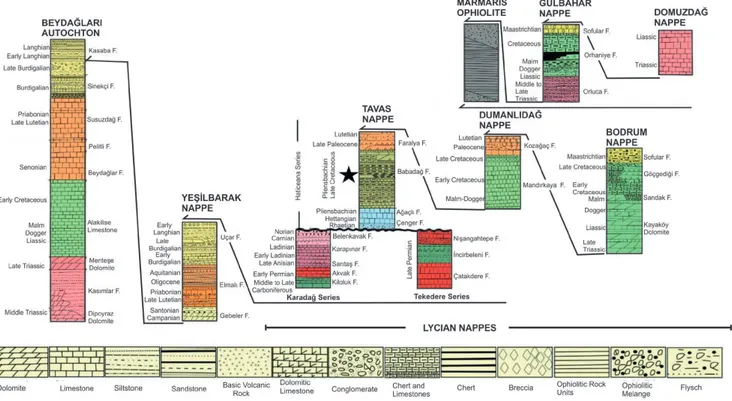
phiboliteschistphyllite and marble (ŞENGÖR et al., 1984; CAN DAN et al., 1998; BOZKURT, 2001; DORA, 2007; BOZKURT, 2004). The Lycian Nappes consist of southimbricated nappes, investigated under different names (GRACIANSKY et al., 1967; GRACIANSKY, 1968; BRUNN et al., 1971; POISSON, 1977; YILMAZ, 1981; ERAKMAN et al., 1982; ŞENGÖR et al., 1984; TEKELİ, 1984; OKAY, 1989; ERSOY, 1990, 1991; ŞENEL et al., 1994; ŞENEL, 1997a, 1997b; KOZUR, 1998; COLLINS & RO BERTSON, 1998, 1999, 2003; KONAK, 2003; DANELIAN et al., 2006; ŞENEL, 2004, 2007; GÖNCÜOĞLU, 2011; VACHARD & MOIX, 2011; ÖZCAN et al., 2012; MOIX et al., 2013). ŞENEL et al. (1994) separated and mapped six main nappe sheets in the northern part of the Lycian Nappes; the Tavas Nappe, the Bodrum Nappe, the Dumanlıdağ Nappe, the Domuzdağ Nappe, the Gül bahar Nappe and the Marmaris Ophiolite Nappes (Figs. 2, 3).
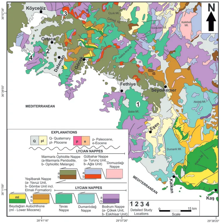
The geological map (Fig. 2) reveals that the studied locations are surrounded mainly by the Çökek unit of the Bodrum Nappe, together with the Marmaris Peridotite and Ağla unit of the Gül bahar Nappe. The Çökek unit contains the Upper TriassicLiassic shallow carbonate shelf product of the Kayaköy dolomite; the DoggerMalm reef front dolomitedolomitic limestones of the Sandak Formation; the Cretaceous continental slopedeep sea ba sin products of calciturbidites and cherty micrites of the Göçgediği Formation; and the Upper Senonian flysch and limestonebearing Karaböğürtlen Formation deposited under variable deep sea basin conditions. The Ağla Unit includes the MiddleUpper Triassic mafic volcanics, radiolarites and cherty limestone deposited in the deep sea environment. The Marmaris Peridotite is composed of the Lower Cretaceous harzburgite, gabbro and diabase (Figs. 2, 3; ŞENEL, 1997a, 1997b, 2004, 2007; SOYCAN et al., 2015).
Figure 2. The tectonic units of the study area, and location of the measured stratigraphic sections (1: Babadağ sections locations, 2: Karadon sections locations, 3: Yangı section location) and detailed observation place (4: Bozburun hill location) (modified from ŞENEL, et al., 1989, 1994; ŞENEL, 1997a, 1997b, 1997c).
Geologia Cr
oatica
Geologia Croatica 74/1
4
The Tavas Nappe (TriassicEocene) unconformably overlies the Karadağ Series (CarboniferousTriassic limestone, dolomite and dolomitic limestone; quartz sandstone; shale) and the Teke dere Series (Upper Permian recrystallized limestones, volcanic and bedded chert interbedded green sandstone, limestone, dolo mite and dolomitic limestone); and tectonically overlies the Yeşilbarak Nappe (Upper Cretaceous limestone, Eocene clastics and limestone and Lower Miocene clastics and limestone), (Figs.. 2, 3; ŞENEL et al., 1994; ŞENEL, 1997a, 1997b, 1997c, 2004). The Tavas Nappe from bottom to top is characterized by rock as semblages of the RhaetianLower Liassic sandstone, conglomera te and mudstone of the Çenger Formation deposited initially in the continental (fluvial and fan) and later shorebackshore environ ment; the Liassic algae, coral bearing limestone, and dolomitic limestone with chert micrites, chert and shale bearing Ağaçlı Formation (a product of the stable shallow carbonate shelf); the ToarcianMaastrichtian limestonescalciturbidites of the Babadağ Formation deposited in the continental slope and basin; and the Upper PalaeoceneMiddle Eocene mafic volcanics, micrite, breccia, and sandstone of the Faralya Formation (products of variable depositional environment conditions), (Fig. 3; ŞENEL, 1997a, 1997b; ŞENEL, 2007).
A Middle Jurassic age was proposed for the lower parts of the Babadağ Formation from radiolarians, benthic foraminifera in Tavas town (NW of the study area, Fig. 1; SOYCAN et al., 2009, 2011, 2015). In and around the towns of Fethiye and Köyceğiz (Fig. 2), the Babadağ Formation contains a Red Micritic Member at the base (including Ammonitico-rosso facies, locally breccia and chert, with the age of the member reported as Upper Toarcian), An oolite bearing Limestone member in the middle part (locally with peloid and nodular chert), has a reported age as Upper Dogger – Malm. Planktonicbenthic foraminifera and rud ist fragment bearing calciturbidites, Globotruncana sp. and chert bearing micritic limestone form the upper member of the forma tion (ŞENEL, 1997a, 1997b). This upper member of the Babadağ
Formation including calciturbidites in Bozburun hill was studied in detail by GÜL (2015) and SARI (2017). SARI (2017) deter mined rudist shell fragments, benthic foraminifera (Orbitoidae) and rare gastropods (denoting the Late Maastrichtian) in the up permost part of the Bozburun hill, and defined several different forms of Globotruncana sp. from foraminiferal bearing wacke stones in the lower part (designated as being of Late Campanian Late Maastrichtian age).
3. MATERIALS AND METHODS
Four locations were selected in an attempt to achieve the objec tives of this study depending on forestrymaquis cover, road ac cess and exposure quality. A total of six sedimentary sections were measured at three different locations on Babadağ Mountain (Babadağ1, 50m; Babadağ2, 120 m; Babadağ3, 100 m; location 1 in Figs. 2, 4a), Ortaca town (Karadon1, 30 m; Karadon2, 20 m; location 2 in Figs. 2, 4b) and Yangı Village (Yangı section, 170 m; location 3 in Figs. 2, 4c). The Bozburun hill area is another study location (location 4 in Fig. 2). This region has already been documented in previous studies (GÜL et al., 2013; GÜL, 2015; SARI, 2017) due to its visible exposures in the field; however, the sedimentary textures, structures, and lateral and vertical facies changes have not been previously documented. Based on litho logical variations, sampling was carried out at 12 m intervals for mineralogical, chemical and petrographic analyses. A total of ninetynine samples were collected during the field studies (22 from the Babadağ Sections; 40 from the Karadon Sections; 23 from the Yangı Section, 14 from the Bozburun hill region); eightyfour thin sections (22 from the Babadağ Sections; 26 from the Karadon Sections; 22 from the Yangı Section, 14 from the Bozburun hill region) were prepared in the Thin Section Prepa ration Laboratories at the General Directorate of Mineral Re search and Exploration (MTA, Ankara, Turkey). The thin sec tions were examined under binocular petrographic microscopes and the grainsize of the calciturbidites was determined at the
Geologia Cr
oatica
Department of Geological Engineering at Muğla Sıtkı Koçman University.
In this study we preferred to use the terms calcilutite (clay size), calcisiltite (silt size), calcarenite (sand size) and calcirudite (gravel size) to classify the calciturbidites in terms of the known grain sizes proposed by previous studies (GRABAUA, 1904; UD DEN, 1914; WENTWORTH, 1922; FOLK, 1980; FLÜGEL, 2004). A combined classification scheme of FOLK (1962), DUN
HAM (1962) and EMBRY & KLOVAN (1971) was followed for carbonate rocks. The classification of FLÜGEL (2004) was used to differentiate the samples according to the proposed Standard Microfacies Classification (SMF) to understand the depositional characteristics (PRICE, 1977; WATTS, 1987; REIJMER et al., 2008, 2012; HAAS et al., 2010; RUBERT et al., 2012).
The mineralogical compositions of the samples were deter mined by the Xray diffraction method. Thirty representative sam
Geologia Cr
oatica
Geologia Croatica 74/1
6
ples of calcilutites and finegrained calcarenites (nine from the Babadağ Sections; eleven from the Karadon Sections; five from the Yangı Section, and five from the Bozburun hill region) were analy sed by a Panalytical Expert Pro diffractometer equipped with a Cu tube at 40kV voltage and 30mA current with a scanning rate of 2°/min at the MineralogyPetrography Laboratory at the General Directorate of Mineral Research and Exploration (Ankara, Turkey).
Xray fluorescence analysis was performed to determine the major oxide compositions of 30 calciturbidite samples. GÜL (2015) stated that microcrystallinecryptocrystalline cherts are present in
the calciturbidite levels, however he did not address their diagenetic properties and textures. SEMEDS analyses through crosssections were carried out at the Research and Application Centre for Re search Laboratories at Muğla Sıtkı Koçman University (Muğla, Turkey). The specimens were sputter coated with gold (Emitech K550X Sputter Coating Systems). Samples were examined under a scanning electron microscope (SEM) (Jeol JSM7600F, Japan) at an accelerating voltage of 15 kV. Elemental characterizations of the samples were done using the SEM equipped with Energy Disper sive Xray Spectrometry (EDSOxford Instrument).
Geologia Cr
oatica
4. RESULTS
4.1. Lithostratigraphy of the Babadağ Formation This study focuses on the calciturbidites of the Babadağ Forma tion and its lithological features. The Babadağ Formation is com posed mainly of calcilutite, calcisiltite, in some parts calcarenite
and rarely calcirudite in its upper parts (ŞENEL, 1997a, 1997b; GÜL, 2015; SARI, 2017).
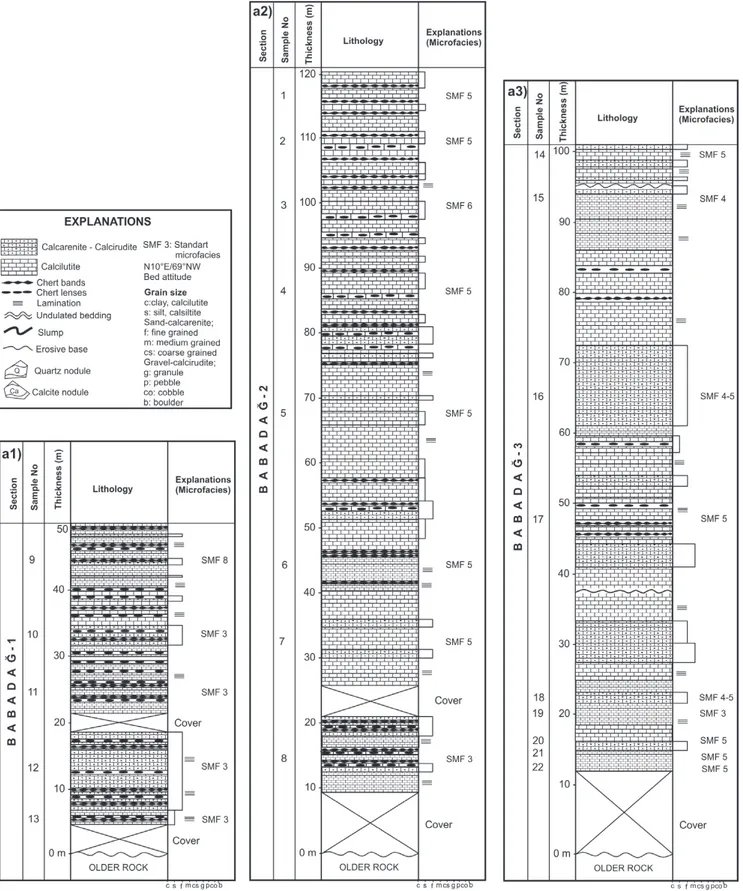
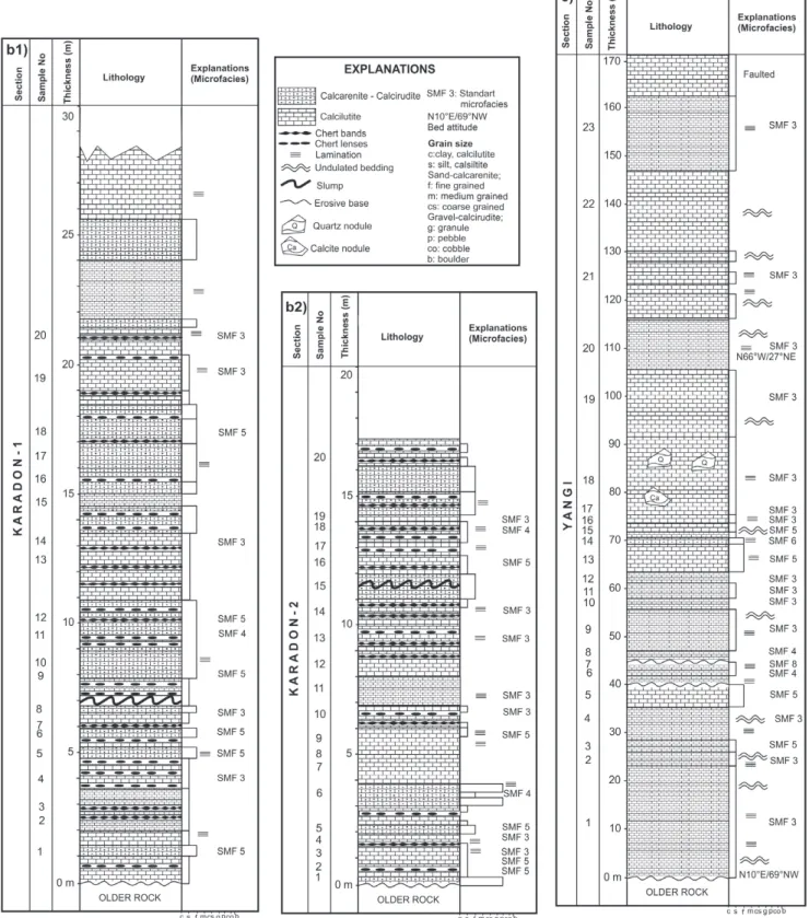
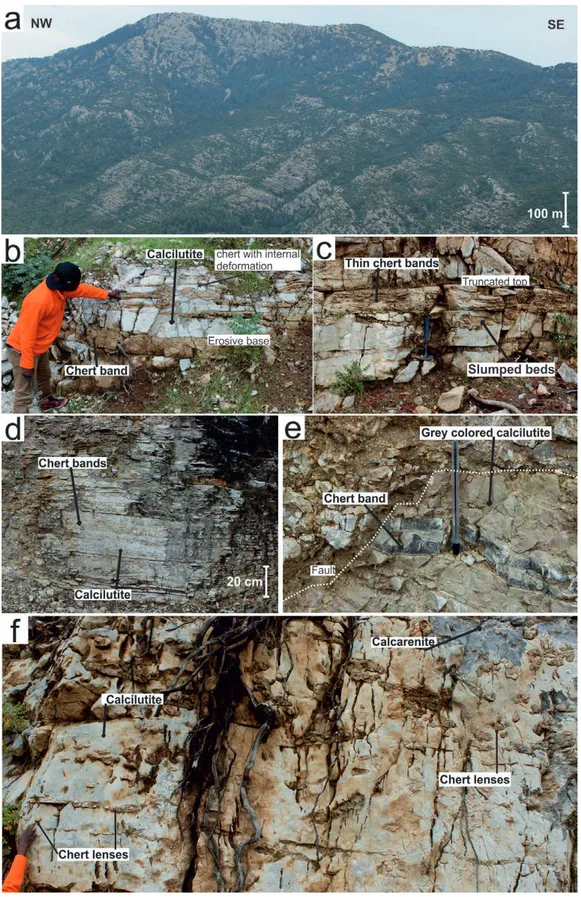
Babadağ Sections: These sections were measured at Babadağ Mountain, which is located at 56 km south west of Fethiye Town (Fig. 2). In this region, the Babadağ formation con formably overlies the Ağaçlı Formation and is overlain by the
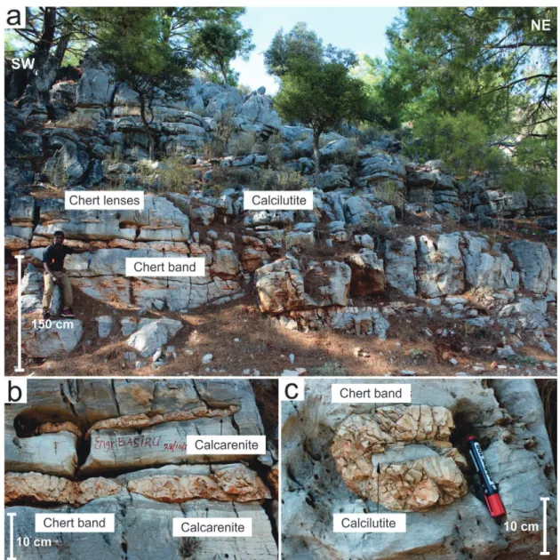
Figure 5. Field photographs showing the lithological properties of calciturbidites in several stratigraphic levels of the Babadağ sections. (a) General view of calci-turbidites in Babadağ. (b) thick bedded calcilutite with chert bands, (c) grey-coloured, thin bedded calcilutite, (d) dark-grey, thin bedded calcarenite, (e) thin bed-ded calcarenite cut by fault, (dotted line shows the boundary between the deformed and undeformed parts of the calcarenite) (f) grey coloured, thick bedbed-ded calcilutite with chert bands.
Geologia Cr
oatica
Geologia Croatica 74/1
8
Faralya Formation (Fig. 3). In addition, some levels of the Babadağ Formation are tectonically overlain by the Bodrum Nappe. The large part of Babadağ Mt. is covered with forests, making it difficult to find a straight section to measure (Fig. 4a). Some exposures were difficult to reach due to lack of proper roads and the risk of rock falls. Observations showed that the unit was faulted, folded, overturned, and highly deformed. Strati graphic sections were measured from the possible top point of the Babadağ Mountain, through the pathways opened for Babadağ paragliding centre.
The Babadağ1 section (50 m) measured (Fig. 4a1) at the up per part is considered to be the youngest part of the Babadağ For mation (Fig. 5). The Babadağ2 section (120 m) (Fig. 4a2) was measured in the faulted and folded middle part of the Babadağ Formation. The Babadağ3 section (100 m) (Fig. 4a3) was mea
sured in the lowermost part of the formation. The Babadağ1 and Babadağ2 sections were formed by the alternations of pinkgrey, thin (35 cm) – medium (1520 cm) thick bedded (3040 cm), ero sive based, truncated topped, calcilutitecalcarenite units in places. Thinlayered (23 cm), locally slumped, chert bands and lenses are observed at the base of the unit, however they are mostly absent in the upper levels. Moreover, the Babadağ3 sec tion contains thin bedded (25 cm) calcilutite and thin to medium bedded (415 cm) calcarenite alternation with chert bands (35 cm thick, 520 m long) and lenses (510 cm thick, 3050 cm long) (Fig. 4a; KORE, 2018).
Karadon Sections: The Karadon Sections are located to the NW of Dalaman Town (Fig. 2). Calciturbidite layers are exposed along the road cut to the south of Ortaca town. The Babadağ For mation is normally faulted in the eastern part and covered with
Figure 6. Field photographs showing the calciturbidites in Karadon sections. (a) General view of calciturbidites in Karadon area, (b) pinkish-grey calcilutite with chert bands, (c) reddish-grey, fine-grained calcarenite with chert-bands, (d) thick bedded calcilutite with chert-band, (e) fine-grained calcarenite with slumped chert.
Geologia Cr
oatica
alluvium. Within the Karadon neighbourhood, the Marmaris Ophiolite Nappe tectonically overlies the unit, while the Faralya Formation consisting of volcanic rocks and young sediments un conformably overlies the unit in the western part.
The Karadon1 section is 29 m thick (Figs. 4b1, 6). At the base, there are sublevels of highly brokenfragmented calcitur bidites. The next 4 m consists of thin bedded (27 cm) calcilutites intercalated with thin to medium bedded (215 cm) calcarenite (Fig. 4b1). The subsequent 17 metres (between 4 m and 21 m) contains alternations of pinkish grey, laminated to thinly (25 cm) undulating bedded calcilutite thin to medium bedded (215 cm) undulating calcarenite, as well as slumped, redgrey chert bands (310 cm thick, 315 m long) and lenses (530 cm thick, 15 cm 2 m long) (Figs. 6b6e). The next 8 metres contains laminated to thinly bedded (25 cm) calcilutite and thin to medium bedded (2
15 cm) calcarenite layers without chert (Fig. 4b1). The Karadon2 section was measured from the southern wing of the small fold that contains pinkishgrey coloured, laminated to thinly bedded (25 cm thick), locally undulating calcilutite and thin to medium (215 cm) locally undulating bedded and slumped calcarenite and calcirudite, redgrey chert bands (110 cm thick, 715 m long) and lenses (310 cm thick, 30 cm 2 m long) (Fig. 4b2).
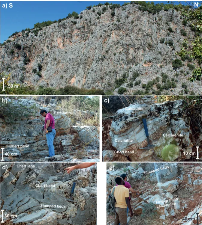
Yangı section: This section was measured in Yangı village about 23 km northeast of Köyceğiz (Fig. 2). A 170 m thick cal citurbidite succession was measured. The Yangı section is com posed predominantly of thin (25 cm)mediumthick (1017 cm) bedded, undulating, creamyellowgreyreddish coloured lami nated calcilutite, laminated calcisiltite and finegrained calcareni te (Figs. 4c, 7). Large chert nodules were observed near to the middle of the unit. Unlike the chert observed in other areas, these were
Figure 7. Field photographs showing the calciturbidites in the Yangı section; (a) General view of calciturbidites in the Yangı section, (b) grey coloured calcilutite, (c) yellow, laminated, thin bedded calcilutite, (d) undulating, thin bedded calcilutite, (e) yellow, pink coloured undulating bedded calcilutite.
Geologia Cr
oatica
Geologia Croatica 74/1
10
found to be irregularly shaped (2030 cm thick, 13 m long). A slump was identified at 110 metres in the section (Fig. 7).
Bozburun hill: Bozburun hill is located on a different nappe slice, about 10 km southwest of the Karadon Section. On the Boz burun hill, calciturbidites of the Babadağ Formation overlie the older Tavas Nappe deposits, and are unconformably overlain by the Faralya Formation. The Bozburun hill was previously studied in detail (GÜL et al., 2013; GÜL, 2015; SARI, 2017). They re ported that Bozburun hill is composed of mainly laminated and thinly (25 cm) undulating, bedded calcilutite at the base, lami nated, thin (48 cm) to medium (1025 cm) bedded calcarenite mainly laminated and thinly (25 cm) undulating, bedded calci lutite alternations with chert layers in the middle, while thin (48 cm) to medium (1025 cm) bedded calcarenites medium (1025 cm) to thickly (30100 cm) bedded calcirudites dominate the up permost part of the succession (Fig. 8).
4.2. Petrography and compositional changes
Babadağ sections: A total of twentytwo samples from the Babadağ sections were examined petrographically. These sam ples are mainly characterized as micritic mudstone, wackestone, packstone and sparitic grainstone (DUNHAM, 1962; EMBRY &
KLOVAN, 1971). However, there are minor occurrences of float stones and rudstones (EMBRY & KLOVAN, 1971).
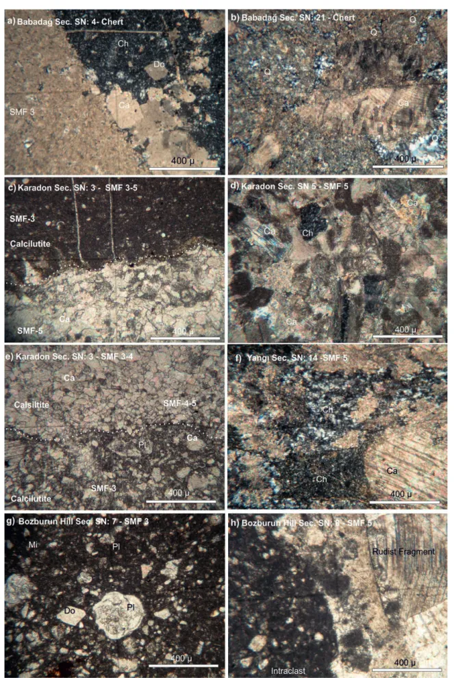
SMF 3 (well sorted; micrite, fosiliferous micrite, mudstone wackestone; contains planktonic foraminifera, rudist shell frag ments, calcite infillings through the cracks) and SMF 5 (well moderatelypoorly sorted; packed biomicrite packstone, unsorted biosparitegrainstone; includes whole fossil and fossil fragments (rudist), calcites with perfect cleavages, large calcite infillings) type micro facies are dominant facies in Babadağ sections. SMF 4 (wellmoderatelypoorly sorted; packed biomicritewackestone, packstone; consist of fossil fragments (rudist), and calcite infill ings), SMF 6 (poorly sorted; packed biomicrite, rudstone; in cludes rudist fossil (size > 2 mm and the ratio > 10 %), and calcite filling the cracks) and SMF 8 (moderately sorted; fosiliferous bio micrite, wackestone; made up of rudist fragments, and calcite infillings) are other less common components (Figs. 4, 9a, 9b). Petrographic studies reveal the presence of chert, dolomite, cal cite, quartz, micrite, planktonic foraminifera and rudist frag ments (Figs. 9a, 9b). The samples were interpreted as medium thin laminated calcilutite and calcarenite. They characterize deposition in the deep sea (Facies Zone (FZ)1), deep shelf (FZ 2), toeshelf (FZ3), and slope (FZ4) environments (Fig. 10).
Figure 8. Field photographs showing the calciturbidites in Bozburun hill; (a) General view of calciturbidites in Bozburun hill; (b) thick bedded layered calcilutite with abundant chert bands and lenses; (c) calcilutite with chert lenses.
Geologia Cr
oatica
Figure 9. Photomicrographs of the Babadağ Formation; a) Cross polarized microview of the silicification and dolomitization of SMF-3 facies in the Babadağ Sec-tions; b) Cross polarized microview of the relatively coarser quartz mineral replacing calcite of fossil fragments; c) Calcilutite-SMF-3 showing an undulatory contact with Calcisiltite-SMF-5. Micritization and or recrystallization may lead to this type of contact. Coarser-grained sediment transportation may also lead to an erosive contact with soft-finer-grained sediment; d) Cross polarized microview of the SMF-5 in the Karadon sections; e) Calcilutite-SMF-3 has an undulatory contact with Calcisiltite-SMF-5; f) Cross polarized view of silicification in the Yangı section; g) Microview of the SMF-3 facies in Bozburun hill; h) Intraclast and coarse-grained fossil fragments bearing SMF-5 facies in the Bozburun hill (Q: Quartz, Ch: Chert; Do: Rhombohedral dolomite; Ca: Calcite; Pl: Planktonic foraminifera).
Geologia Cr
oatica
Geologia Croatica 74/1
12
Karadon sections: Twentysix samples from the Karadon sections were examined under the petrographic microscope (Figs. 9c, 9d, 9e). The studied samples are micritic mudstonepack stonewackestonebindstone, and floatstone, and sparitic grain stone (DUNHAM, 1962; EMBRY & KLOVAN, 1971). SMF 3 (very wellwellmoderately sorted; fosiliferous micrite, mud stonewackestone; includes planktonic foraminifera, sometimes rudist fossil fragments, and calcite infillings) and SMF 5 (well moderatelypoorly sorted; packed biomicrite, packstone, un sorted biosparitegrainstone, fosiliferous biosparitefloatstone; consist of calcite filling the fractures, whole (planktonic fo raminifera) and fragments of fossil (rudist), and stylolite) type facies are the dominant facies. SMF 4 type (very poorly sorted; unsorted biomicrite, packstone; made up of siltsand size fossil fragmentrudist) is the other less common component (Figs. 9c, 9d, 9e). They characterize the deposition in deep sea (FZ1), deep shelf (FZ2), toeshelf (FZ3), and slope (FZ4) (Fig. 10).
Yangı section: Twentytwo samples from the Yangı section were subjected to microscopic examination and are predomi nantly of micritic mudstonefloatstone (fosiliferous biomicrites) and sparitic rudstone (unsorted biosparite)grainstone (DUN HAM, 1962; EMBRY & KLOVAN, 1971; Figs. 4, 9f) composi tion. SMF 3 (wellmoderatelypoorly sorted; micrite, fosiliferous micrite, mudstonewackestone; consist of whole planktonic fo raminifera, rudist shell fragments, calcite infillings) is the domi nant facies in the Yangı section. SMF 5 is wellmoderatelypoorly sorted; packed biomicritepackstone, unsorted biosparitegrain
stone; containing whole fossil (planktonic foraminifera) and fos sil fragments (rudist), and large calcites with perfect cleavages and infillings), SMF 4 is wellpoorly sorted; unsorted biomicrite, packstone; made up of siltsand size fossil fragment, rudist. SMF 6 is very well sorted; packed biomicrite, rudstone; includes rud ist fossil (their size larger than 2mm and their ratio > 10 %), and calcite filling the cracks. SMF 8 (moderatelypoorly sorted; fo siliferous biomicrite, wackestonefloatstone); made up of rudist fragments (size> 2mm and the ratio > 10 %), calcite infillings) are other secondary components. Chert and calcite are dominant in the Yangı section (Fig. 9f). They characterize the deposition in deep sea (FZ1), deep shelf (FZ2), toeshelf (FZ3), and slope (FZ4) (Fig. 10).
Bozburun hill: Fourteen samples from the Bozburun hill were studied. These are dominated by micritic packstonemud stonewackestone with minor floatstone, and sparitic grainstone (DUNHAM, 1962; EMBRY & KLOVAN, 1971; Figs. 9g, 9h). SMF 3 (well sorted; fosiliferous micrite, mudstonewackestone; consist of planktonic foraminifera, rudist shell fragments, calcite infillings through the cracks) and SMF 5 (wellmoderatelypoorly sorted; packed biomicritepackstone, unsorted biosparitegrain stone; contain whole fossil and fossil fragments (rudist and ben thic foraminifera fragments), and large calcites with perfect cleavages filling the cracks) are the main facies types. SMF 4 type (poorly sorted; packed biomicritepackstone; includes fossil frag ments (rudist), calcite infillings) is the secondary component. Cal cite, dolomite, quartz, micrites, and planktonic foraminifera
Figure 10. Standard Microfacies (SMF) and the related Facies Zone (FZ) of samples were described according to FLÜGEL (2004) classification (rimmed carbonate platform) and facies model (SMF: standard microfacies, FZ: the facies zone).
Geologia Cr
oatica
(SARI (2017) defines different forms of Globotruncana sp.) are common in the samples (Figs. 9g, 9h). They characterize depo sition in deep sea (FZ1), deep shelf (FZ2), toeshelf (FZ3), and slope (FZ4) (Fig. 10).
4.3. Whole Rock Mineralogy and Geochemistry
Xray diffractograms reveal the dominance of quartz and calcite in all samples (Fig. 11). Quartz is observed with its prominent peak of 3.34 Å at 26° 2θ; while intense reflection of calcite is de termined at 29° 2θ with 3.03 Å dspacing. Dolomite with very weak intensity at around 31° 2θ and 2.89 Å dspacing is also re cognized in the diffractograms (Figs. 11a, b, c, d). The mineralo gical findings on the bulk compositions are consistent with the microscopic observations.
The calciturbidite layers away from the chert lensesbands contain calcite minerals of various sizes. The regional and one line scanmode analysis on these layers by SEMEDS confirms the dominance of Ca, C and O as the major elements. Si amount is negligible. On the other hand, SEMEDS analysis on the sam ple from Bozburun hill, close to the chert bands and lenses, points to the Si enrichment and Ca depletion, indicating the diagenetic replacement of Ca by Si (Fig. 12). Additionally, microcryp tocrystalline calcite and quartz minerals are observed under SEM (Fig. 12 A, C, D). The EDS results are compatible with the mine ral compositions (Fig. 12b). Figure 12e is the image of oneline SEMEDS analysis which illustrates the presence of the elements Si, Ca, Mg and C. Ca enrichment with very low Si content at the beginning of the measured line is associated with microcryp tocrystalline calcite; whereas a higher Si content was determined towards the end of the line with negligible Ca. Very low and al most negligible amounts of Mg are also recorded by EDS scan. XRF results of the 30 samples are presented in weight per centages (wt.) in Table 1. A high puritychert sample has more than 80% SiO2, while calciturbidite samples away from the cher
tification or silicification intervals include predominantly >50 % CaO (Table 1). Calciturbidite samples affected by silicification contain 0.230 % SiO2. This inverse relationship between Si and
Ca is also confirmed by SEMEDS observations (Fig. 13). The
Babadağ, Karadon sections, and Bozburun hill samples show similar chemical compositions of very low alkali and alkaline earths. However, a few samples of the Yangı section have two to four times higher values of the Na2O, K2O, Al2O3, MgO, TiO2
and Fe2O3 values than the average values of the other sections
(Table 1). LOI (Loss of Ignition Values) values are in coherence with the Caenriched samples (Table 1).
5. DISCUSSION
5.1. Sedimentary features and related depositional environments
The Lycian Nappes units were originally attributed to the south ern part of the northern branch of the Neotethys Ocean located north of the Menderes Massif (Fig. 1) (ŞENGÖR & YILMAZ, 1981; COLLINS & ROBERTSON, 1998; OKAY, 2001). They mi grated to the south passing over the Menderes Massif units and were emplaced between the Menderes Massif and the Beydağları Autochthone (Fig. 1; ŞENEL, 1997a; KOZUR et al., 1998; RO BERTSON, 2000; BOZKURT, 2004). The map of the Triassic Cretaceous palaeogeography of the Eastern Mediterranean indi cates that the northern Neotethys Ocean extended from Greece (Pelagonian Zone, Pindos Zone, Cyclades etc.) in the west to Iran in the east including the Taurides (Western Taurides, Lycian Nappes, BeyşehirHoyranHadim Nappes etc.) (Fig. 1; ROBERT SON & DIXON, 1996; ROBERTSON & MOUNTRAKIS, 2006; VACHARD & MOIX, 2011). The Lycian Nappes represent a tran sition zone between the Greek Hellenides and the CentralEastern Taurides–Turkey (MOIX et al., 2013). The Late Cretaceous period was represented by a compressional regime that led to the frag mentationnappe formation and locally different depositional set tings, such as carbonate platform, continental slope, and deeper marine environments in the Neotethyan Ocean (ROBERTSON & DIXON, 1996; ROBERTSON & MOUNTRAKIS, 2006; VACHARD & MOIX, 2011).
The CenomanianConiacian rudist bearing limestones and the CenomanianCampanian micritic limestone are unconforma bly overlain by the Campanian? – Maastrichtian units of breccia, conglomerates, carbonated sandstones (calciturbidites?) and pe
Geologia Cr
oatica
Geologia Croatica 74/1
14
Figure 12. (a) General SEM images of sample 14 from Bozburun hill. (b) Regional EDS analysis on the red rectangle in figure A. (c) SEM view of the micro-crypto-crystalline quartz bearing chert part of figure A. (d) SEM view of the micro-cryptomicro-crypto-crystalline calcite mineral bearing calcilutite of figure A. (e) One-line scan mode EDS analysis on sample 14 indicating an inverse relation between Si and Ca elements proving that Si replaced the Ca during the diagenesis.
Geologia Cr
oatica
lagic limestones with Globotruncana sp. in the Bornova Flysch Zone in the ManisaSpil Mountain on the western end of the İzmirAnkara Zone in the northern part of the northern Neo tethyan Ocean (SOLAK et al., 2015 and references therein). Dur ing the Campanian? – Maastrichtian period the platform was drowned and transformed into the outer platform and continental slope environment (SOLAK et al., 2015). Similar age data was reported for the upper part of the Babadağ Formation in the Boz burun hill area (SARI, 2017, and references therein). Similar planktonic foraminiferal content was also observed in the Babadağ Sections, the Karadon Sections and the Yangı Section. However, there is no detailed palaeontological analysis of the fos sil content. The northern Neotethyan Ocean covered large areas of the northern part of the Menderes Massif (ŞENGÖR & YILMAZ, 1981). This ocean hosted important limestone, calci turbidite deposits, rudist reefs, and ophiolites (ŞENGÖR & YILMAZ, 1981). Dependent on compressional regime during the Late Cretaceous, nappe slices of this ocean were transported to the south and formed the Lycian Nappes, some slices were trans ported to the north and formed the Bornova Flysch Zone (ŞENGÖR & YILMAZ, 1981).
Upper Cretaceous calciturbidite deposits with rudist frag ments and planktonic foraminifera were reported from the Ana masAkseki Autochthone, the Antalya Nappes and the Alanya Nappes of the Southern branch of the Neotethys Ocean (ŞENEL et al., 1998). In the southern part of the central Taurides, within the upper levels of the Geyikdağı tectonic unit, chert, brecciated sandy, micritic limestone alternations (Campanian) and then dark red coloured pelagic limestone and slumped hemipelagic lime stone (Upper Campanian) of the Cehennemdere Formation were observed by KOÇ et al. (2016).
The existence of similar units was also reported from west of the study area. CLIFT & ROBERTSON (1990) reported that the Argolis Peninsula in southern Greece contains Upper Creta ceous pelagic limestones, calciturbidites, limestoneconglomera tes and slumped units in the middle of the Hellenides. SKOURT SISCORONEOU et al. (1995) reported that the Ionia Zone of the Hellenides in Western Greece contains the Tithonianearly San tonian pelagic limestone with chert and the Upper Santonian Maastrichtian detrital limestone with chert nodules. Similarly, LE GOFF et al. (2015) reported deformed gravityflow deposits within the Ionia basin. The Pindos Zone in Western Greece also
Table 1. Major oxide compositions (wt.%) of the studied calciturbidite samples
Major oxide (wt.%) SiO2 TiO2 Al2O3 Fe2O3 MgO CaO Na2O K2O P2O5 MnO LOI
Babadağ section B1 86.90 0.10 0.20 0.60 0.10 6.60 0.10 < 0.10 < 0.10 0.10 5.30 B2 30.40 0.10 0.10 0.20 0.30 37.80 0.10 < 0.10 < 0.10 0.10 30.90 B3 1.60 0.10 0.30 0.30 0.40 54.00 0.10 0.10 < 0.10 0.10 43.00 B4 0.50 0.10 0.20 0.10 0.40 54.80 0.10 0.10 < 0.10 0.10 43.60 B5 0.60 0.10 0.20 0.10 0.30 54.90 0.10 < 0.10 < 0.10 0.10 43.60 B6 0.40 0.10 0.10 0.10 0.40 54.90 0.10 < 0.10 < 0.10 0.10 43.80 B7 0.70 0.10 0.10 0.10 0.30 55.00 0.10 <0.10 < 0.10 0.10 43.50 B8 0.20 0.10 0.20 0.10 0.30 54.80 0.10 <0.10 <0.10 0.10 44.10 B9 18.40 0.10 0.10 0.10 0.40 55.00 0.10 < 0.10 < 0.10 0.10 25.70 Average 15.52 0.10 0.17 0.19 0.32 47.53 0.10 <0.10 <0.10 0.10 35.94 Karadon section K1 0.60 0.10 0.10 0.10 0.30 54.90 0.10 < 0.10 < 0.10 0.10 43.70 K2 2.00 0.10 0.20 0.10 0.30 54.20 0.10 < 0.10 < 0.10 0.10 42.90 K3 22.20 0.10 0.50 0.20 0.30 42.20 0.10 0.10 < 0.10 0.10 34.20 K4 47.70 0.10 0.30 0.30 0.20 28.50 0.10 < 0.10 < 0.10 0.10 22.70 K5 18.30 0.10 0.20 0.20 0.30 44.60 0.10 < 0.10 < 0.10 0.10 36.10 K6 1.50 0.10 0.50 0.40 0.40 53.80 0.10 0.10 0.10 0.10 42.90 K7 0.40 0.10 0.10 0.10 0.30 55.10 0.10 0.10 0.10 0.10 43.50 K8 53.30 0.10 0.30 0.40 0.20 25.10 0.10 0.10 0.10 0.10 20.20 K9 0.30 0.10 0.10 0.10 0.30 55.00 0.10 0.10 0.10 0.10 43.70 K10 0.40 0.10 0.10 0.10 0.30 55.10 0.10 0.10 0.10 0.10 43.50 K11 0.40 0.10 0.10 0.10 0.30 55.10 0.10 0.10 0.10 0.10 43.50 Average 13.37 0.10 0.23 0.19 0.29 47.60 0.10 0.10 <0.10 0.10 37.90 Yangi section Y1 18.40 0.20 5.10 2.20 1.00 39.00 0.40 0.90 0.10 0.10 32.60 Y2 18.40 0.20 5.10 2.10 1.00 39.10 0.50 0.90 0.10 0.10 32.50 Y3 18.30 0.20 4.10 1.80 0.80 40.10 0.60 0.60 0.10 0.10 33.30 Y4 0.30 0.10 0.10 0.10 0.30 55.10 0.10 < 0.10 <0.10 < 0.10 43.90 Y5 0.30 0.10 0.10 0.10 0.30 55.10 0.10 < 0.10 < 0.10 <0.10 43.90 Average 11.14 0.16 2.90 1.26 0.68 45.68 0.34 0.80 <0.10 <0.10 37.24
Bozburun hill samples
BH1 0.40 0.10 0.10 0.10 0.40 54.80 0.10 < 0.10 < 0.10 < 0.10 44.00 BH2 0.50 0.10 0.10 0.20 0.30 54.80 0.10 < 0.10 < 0.10 < 0.10 43.90 BH3 0.90 0.10 0.10 0.20 0.30 54.80 0.10 <0.10 < 0.10 < 0.10 43.50 BH4 0.60 0.10 0.20 0.10 0.40 54.60 0.10 < 0.10 < 0.10 < 0.10 43.90 BH5 0.90 0.10 0.20 0.10 0.20 54.70 0.10 < 0.10 < 0.10 < 0.10 43.70 Average 0.66 0.10 0.14 0.14 0.32 54.74 0.10 < 0.10 <0.10 <0.10 43.80
Geologia Cr
oatica
Geologia Croatica 74/1
16
includes Lower Cretaceous radiolaritebearing deepsea sedi ments and continues with Upper Cretaceous pelagic and turbidite deposits (NEUMANN & ZACHER, 2004).
This study reveals that the calciturbidites of the Babadağ Formation include creamgreypink calcilutitecalcisiltite, calca renite and calcirudite (SMF 3, 4, 5, 6, 8) with chert lenses in vary ing ratios. They were predominantly deposited on the slope (FZ 4) to deep sea (FZ1) environment. The highest percentage of the calcilutite (SMF 3) was determined in the Yangı section that pos sibly shows the deepest depositional environment of the Babadağ Formation. Calcilutitecalcisiltitecalcarenite alternations with variable ratio in other sections indicate the impacts of local fac tors (sediment input, feeder mechanisms from the shelf part of the platform) in different parts of the platform. Planktonic fora miniferabearing calcilutite requires the lowest sediment input and deposition from suspension, sandgravel size fragments de rived from the shelf margin led to the formation of calcarenite and calcirudite. The highest proportion of calcirudite at Bozbu run hill may be linked with the closeness of the depositional en vironment to rudist buildups along the shelf margin.
The findings of the XRD, XRF, SEMEDS and petrographic studies indicate the presence of calcite and quartz minerals in the samples. ROBERTSON & DIXON (1996), ROBERTSON & MOUNTRAKIS (2006), VACHARD & MOIX (2011) and seve ral other previous studies suggested that the calciturbidites were deposited on the carbonate platform, continental slope and deep sea environment. Detritus from the shelf included mainly calcite shelled organic buildups on the shelf margin. Thus, the sources of the calciturbidite were similar in chemical composition (domi nantly CaCO3), with varying size (clay to gravel). The inverse
relationship between Si and Ca is possibly due to silicification processes during diagenesis (Figs. 12, 13; Table 1). The presence of calcite in the mineral compositions and Ca in the bulk chemi cal composition of the chert bands and lenses indicates that the silicification process was not completed. Similarly, silica in cal citurbidites reveals incomplete silicification processes. Based on petrographic observations, GÜL (2015) suggested that the quartz replacement with calcite happens without any size change. The size of the calcite minerals influences the growth of chert (Fig. 9). In figure 9a, the replacement of claysilt sized calcite by equal size quartz led to forming, porcelainous, microcrystalline chert; while in figure 9b smallmedium sized quartz substitutes calcite.
Moreover, rhombohedral dolomite crystals were detected in Fi gure 9a. Similar observations were also reported by GÜL (2015) who determined diagenetic effects such as dolomitization, sub stitutionreplacement, and silicification in the units based on pe trographic studies.
5.2. Factors controlling sedimentation
The main controlling factors on the deepsea sediments includ ing calciturbidites are tectonic activity, sealevel fluctuation, ba sin morphologygeometry, sediment input, water chemistry, cur rents, continental slope heightgradient, organic activities, climate changes, etc. (EVERTS, 1991; READING, 1991; REI JMER et al., 1991; HAUGHTON, 1994; RICHARDS et al., 1998; HAUGHTON, 2000; ESCHARD & JOSEPH, 2002; LOMAS & JOSEPH, 2004; DEWEVER et al., 2007; REIJMER et al., 2008, 2012; GARCIACARO et al., 2011; GÜL et al., 2012; RUBERT et al., 2012; HAIRABIAN et al., 2015; REIJMER et al., 2015a, 2015b). These factors may vary from region to region. For exam ple; the main tectonic activities and related sea floor morphology control the sediment input and sediment quantity and thus gra vityflow deposits in the Southern Provence Basin (SE France) (REIJMER et al., 1991; SAVARY et al., 2004; REIJMER et al., 2015b). Moreover, a few cm thick calciturbidite layers at the base of the Lower Cretaceous cherty limestones in Slovakia in the middle of the Western Carpathians are associated with small scale seismic activity (MICHALIK et al., 2012). Additionally, linear source formation, asymmetric geometry of base topogra phy and facies differences of the Jurassic units in the Eastern Al pineSwiss were attributed to a boundary fault (EBERLI, 1987). The calciturbiditic Pliensbachian (Lower Jurassic)Upper Creta ceous series of the Lycian Nappes were interpreted as reflecting the passive continental margin period after the synrift period (MOIX et al., 2013). Sea level changes were responsible for ex cess sediment input and calciturbidite formation in the Bahamas during the Pleistocene (REIJMER et al., 2008, 2015a). Variations in the turbidity flow regime led to the development of lithologi cally different units such as mudstonewackestone, sorted or packed biomicritepackstone etc. (DEWEVER et al., 2007).
Several factors account for the deposition of the calciturbidi tes in the study area. Notable factors among these are discussed below.
5.2.1. Tectonism and depositional basin geometry
Tectonism controls the morphologygeometry of the sea floor, the amount of sediment supply, palaeocurrent direction, entry point of the sediments, sediment quantity, internal structure of the sediments including slumps and flow characteristics (energy, velocity etc. thus facies type) (BOUMA, 2004; GÜL et al., 2012; BAUMGARTNER, 2013).
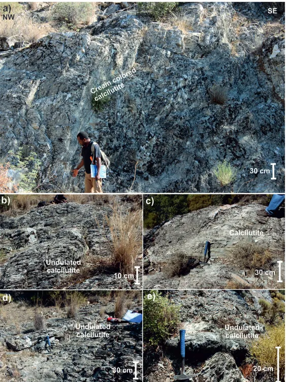
The depositional environments of the Babadağ Formation were interpreted as continental slope, and related platform mar ginshelf margin and deep water (ŞENEL et al., 1994; ŞENEL, 1997a, 1997b, 1997c; COLLINS & ROBERTSON, 1998, 1999; GÜL, 2015; SOYCAN et al., 2015; SARI, 2017; Fig. 10). Seismic activities and/or sea level fluctuation triggered the destabilisation of sediments on the shelfplatform margin areas before the nappe formation and led to the formation of coarsegrain sediments (cal cirudite and calcarenite) on the continental slope and toe of slope (GÜL et al., 2012, 2013; GÜL, 2015). Alternatively, tectonically quiet periods were represented by calcilutite layers. Moreover, an internal deformation (undulating bedding, slumps) of the sedi ments characterized the continental slope environment. Calcite
Figure 13. CaO versus SiO2 plot showing the inverse variation due to
Geologia Cr
oatica
filled joints, folding, faulting, and nappe formation – fragmenta tion of the original carbonate platform was also related to tectonic activities during and after the Lycian Nappe migration. 5.2.2. Sea level fluctuations and sea depth
Sea level fluctuation and related sea depth control the transporta tion and deposition of deepsea sediments (BOGGS, 1987; READING, 1991; GÜRBÜZ, 1999; GERVAIS et al., 2004; REI JMER et al., 2008; GÜL et al., 2011, 2012, 2015; SOYCAN et al., 2009, 2011, 2015). Sea level fluctuations cause destabilization of sediment on the shelf edge and on the continental slope (GÜR BÜZ, 1999; GERVAIS et al., 2004). GÜL et al. (2012) proposed that large scaleregional and/or possibly global sea level changes control depocenter development and largescale sediment differe ntiation, moreover smallscale variation of sea level was possibly due to local tectonic activities that led to the facies variations of the Babadağ Formation. The Standard Micro Facies (SMF) changes and related Facies Zone (FZ) changes indicate that the four main depositional environments were ‘slope, toe of slope, deep shelf, deep sea water basin – FZ 4321’ (Fig. 10). Sealevel fluctuations due to regional uplift and subsidence of the basin may be responsible for these environmental transitions. The falling stage and/or tectonically active period in association with excess sediment input caused the coarsegrained calciruditecalcarenite level in the Babadağ section to represent deposition on slope slope front environments (FZ34; Fig. 10). Subsequent plank tonic foraminifera bearing calcilutite levels were interpreted as a product of the highstand period, low energy level, and quiet deep sea environment (FZ12; Fig. 10) conditions.
5.2.3. Sediment input and sediment type (nature of the source area) Sediment entry, sediment type and sediment quantity have af fected the deepsea sediment characteristics, including geometry and facies differentiation, such as single or multiplesourced sub marine fans, coarse grainedsand rich turbidite systems and a fine grainedmud rich turbidite system depending on depocenter (RICHARDS et al., 1998; GÜRBÜZ, 1999; BOUMA, 2004; GERVAIS et al., 2004; GARCIACARO et al., 2011; GÜL et al., 2011, 2012, 2015).
Calcarenitecalcirudite levels of the Babadağ Formation were formed as a result of the sediments derived from the shelf includ ing rudist buildups. The fragments of these initially accumulated on the shelf margin and tectonic activity/sea level lowering trig gered destabilization and downslope movement. The calcirudite calcarenite (unsorted biomicritesparite or floatstonerudstone) deposited on the slope and toe of slope (FZ 4, 3) depended on ex cess sediment input and a short transportation distance. Generally, 35 cm thick calcarenite and calcirudite levels were defined in the Babadağ, Karadon and Yangı sections, while field observations during this study and GÜL et al. (2013) and GÜL (2015) docu mented 30 cm2 m thick calcirudite levels in the Bozburun hill area, representing excess sediment input and/or close proximity to the source area. The ophiolite belts in the Eastern Mediterra nean including the Neotethyan Oceans evolved from the Jurassic to the Cretaceous (ŞENGÖR & YILMAZ, 1981; ŞENGÖR et al., 1984; ROBERTSON, 2002; ALDANMAZ et al., 2009). The em placement age of the ophiolite was reported as Late Cretaceous (ALDANMAZ et al., 2009). Enrichment in FeAlNa in the Yangı section should be linked with the maficultramafic ophiolitic rocks of the Lycian Nappes. Local sediment input from the ophiolites to the original depositional environment may have resulted in these higher values in the elemental compositions of the samples from the Yangı Section (KORE & GÜL, 2017; KORE, 2018).
Silicification during and after lithification led to the forma tion of chert nodulebands (GÜL et al., 2013; GÜL, 2015; SARI 2017). GÜL (2015) used petrographic results to explain this pro cess. He reported that chert horizons were mostly observed with the calcarenitecalcirudite level on Bozburun hill. In addition, he also documented that porcelainous microcrystalline quartz formed as a result of the replacement of calcilutite, chalcedony type quartz minerals were developed depending on the substitu tion of large calcite minerals such as rudist fragments. Elemental analysis clearly indicates the replacement between the Si and Ca elements via the inverse proportions of these two elements (KORE & GÜL, 2017; KORE, 2018). Silicification slightly pene trated into the calciturbidites at lower and upper part of the chert bands (GÜL, 2015). Furthermore, lateral continuation of the chert bands and lenses is limited over a short distance. The long est chert bed reported by GÜL (2015) is 35 m in the Bozburun hill area. It is thought that the formation of chert depends on the circulation and amount of silicarich water that penetrated the calciturbidites. Thus the permeability and porosity of the host rock (calciturbidites) were to become important factors control ling the silica rich water circulation. Thus, it is anticipated that more chert formation occurred in the calcarenites and calciru dites as in the Bozburun hill, Babadağ1 section, Babadağ2 sec tion, Karadon1 section, and Karadon2 section (Fig. 4). In addi tion, if the chert beds were deposited synsedimentary and alternated with the calciturbidites, long and more regular chert beds could be traced. However, the irregular and short chert oc currences of the Babadağ Formation suggest that they evolved during diagenesis of the calciturbidite via quartz replacing cal cite. In addition to these, postsedimentary diagenetic activities can also be traced by rhombohedral dolomite formations within the cracks already filled by calcites that cut both calciturbidites and cherts.
This study reveals that an investigation on the distant nappe unit that is mapped under the same name, should supply the in formation about the original depositional environment. Detailed analysis of each nappe slice is useful for determining the local controlling factors on deposition besides the general trend con firmation. Other important issues related to calciturbidite depo sition are that they are generally affected by tectonic activities and the depth of the basin. Local sediment typesizequantity may lead to coarsegrain deposition. Calciturbidites play an ac tive role during diagenesis, and also open pathways for chemi cally active liquids through which they can move easily leading to the formation of chert bands and lenses as observed in the study area.
6. CONCLUSIONS
This study documents the compositional changes, and discusses the factors controlling the deposition and sedimentological chara cteristics of the calciturbidites of the Babadağ Formation of the Tavas Nappe in Muğla (SW Turkey). With the help of field obser vations and many analytical methods, the following conclusions are drawn:
The studied calciturbidites comprise mainly calcilutite – cal cisiltite, and calcarenitecalcirudite in a small amount depending on the environmental conditions. Calcarenite and calcirudite oc currences represent deposition on the slope or toe of slope; how ever, the predominance of calcilutite points to deposition in deep shelf and deep sea environments.
Planktonic foraminiferabearing, micritic calcilutites were deposited in the deep marinedeep shelftoe of slope environ
Geologia Cr
oatica
Geologia Croatica 74/1
18
ments. Mostly rudist fragmentbearing, locally slumpedundu lating beddeddeformed calcarenites and to a lesser extent cal cirudites were deposited in the slope environment.
Detailed analysis of each nappe slice belonging to the same nappe unit not only provides general information on the environ ment and lithology, but also indicates local factors including lo cal sediment input etc.
Tectonism and sealevel fluctuations are determined as the main controlling factors on deposition of the Babadağ Formation. Steady, tectonically quiet periods, low sediment input and the ab sence of gravity flows resulted in the deposition of calcilutite micritic sediments. Subsequently, sealevel lowering, tectonically active periods (uplift) and excess sediment input led to the deve lopment of calcarenitecalcirudite levels. Changes of the control ling factors over time triggered the repetition of formation of the finegrained and coarsegrained calciturbidites.
Sediment grain size played an important role during diage netic stages. The coarsegrained calciturbidite supply provided a suitable pathway for Si enrichment water circulation and there fore chert or dolomite formation.
Calcite and quartz were observed as the major mineral com ponents in the samples. Both SEMEDS and XRF analysis show the inverse variation between CaO and SiO2 due to replacement
during diagenesis. Excess silica replacement especially was gene rally observed in calcarenitecalcirudite levels which, in turn, led to formation of the chert bands/lenses. All chert bands con tain a negligible amount of calcite which is due to the incomplete silicification process. Moreover, the Si content of pure calcitur bidite samples either above or below the chert level shows the diffusive characteristics of the Sienriched water.
ACKNOWLEDGEMENT
This study was financially supported by the Scientific Research Projects Office (BAP; project No. 17/118) of Muğla Sıtkı Koçman University, Turkey for the M.Sc. thesis of the first author. The au thors would like to acknowledge the valuable contributions of the anonymous reviewers and editors.
REFERENCES
ALDANMAZ, E., SCHMIDT, M.W., GOURGAUD, A. & MEISEL, T. (2009): Mid ocean ridge and suprasubduction geochemical signatures in spinelperidotites from the Neotethyan ophiolites in SW Turkey: Implications for upper mantle melting processes.– Lithos, 113, 691–708. doi: 10.1016/j.lithos.2009.03.010
BAUMGARTNER, P.O. (2013): Mesozoic radiolarites – accumulation as a function of sea surface fertility on Tethyan margins and in ocean basins.– Sedimentology, 60, 292–318. doi: 10.1111/sed.12022
BEHL, R.J. (2011): Chert spheroids of the Monterey Formation, California (USA): early diagenetic structures of bedded siliceous deposits.– Sedimentology, 58, 325–351. doi: 10.1111/j.13653091.2010.01165.x
BOGGS, S.JR. (1987): Principles of Sedimentology and Stratigraphy.– Macmillan Pub lishing Company, New York, USA, 771 p.
BOUMA, A.H. (2004): Key controls on the characteristics of turbidite systems.– In: LO MAS, S.A. & JOSEPH, P. (eds.): Confined Turbidite Systems.– Geological Society, London, Special Publications, 222, 9–23. doi: 10.1144/GSL.SP.2004.222.01.02 BOZKURT, E. (2001): Late Alpine evolution of the central Menderes Massif, western
Turkey.– Int. J. Earth Sciences, 89, 728–744. doi: 10.1007/s005310000141 BOZKURT, E. (2004): Granitoid rocks of the southern Menderes Massif (southwestern
Turkey): field evidence for Tertiary magmatism in an extensional shear zone.– Int. J. Earth Sciences, 93, 52–71. doi: 10.1007/s0053100303690
BRUNN, J.H., DUMONT, J.F., GRACIANSKY, P., GUTNIC, M., JUTEAU, T., MAR COUX, J., MONOD, O. & POISSON, A. (1971): Outline of the geology of the western Taurids.– Geology and history of Turkey, 225, 17 p.
CANDAN, O., DORA, O.Ö., OBERHÄNSLI, R., ÇETINKAPLAN, M., PARTZSCH, J.H., WARKUS, F.C. & DÜRR, S. (2001): PanAfrican highpressure metamor phism in the Precambrian basement of the Menderes Massif, western Anatolia, Tur key.– Int. J. Earth Sci., 89/4, 793–811.
CLIFT, P.D. & ROBERTSON, A.H.F. (1990): A Cretaceous NeoTethyan carbonate mar gin in Argolis southern Greece.– Geological Magazine, 127, 299–308. doi: 10.1017/ S0016756800014862.
COLLINS, A.S. & ROBERTSON, A.H.F. (1998): Processes of Late Cretaceous to Late Miocene episodic thrustsheet translation in the Lycian Taurides, SW Turkey.– Jour nal of the Geological Society, London, 155, 759–772. doi: 10.1144/gsjgs.155.5.0759 COLLINS, A.S. & ROBERTSON, A.H.F. (1999): Evolution of the Lycian Allochthonous,
western Turkey, as a northfacing Late Palaeozoic to Mesozoic rift and passive con tinental margin.– Geological Journal, 34, 107–138.
COLLINS, A.S. & ROBERTSON, A.H.F. (2003): Kinematic evidence for Late Meso zoic–Miocene emplacement of the Lycian Allochthonous over the Western Ana tolide Belt, SW Turkey.– Geological Journal, 38, 295–310.
DANELIAN, T., ROBERTSON, A.H.F., COLLINS, A.S. & POISSON, A. (2006): Bio chronology of Jurassic and Early Cretaceous radiolarites from the Lycian Mélange (SW Turkey) and implications for the evolution of the Northern Neotethyan ocean.– In: ROBERTSON, A.H.F. & MOUNTRAKIS, D. (eds.): Tectonic Development of the Eastern Mediterranean Region. Geological Society, London, Special Publica tions, 260, 229–237. doi: 10.1144/GSL.SP.2006.260.01.10
DEWEVER, B., BREESCH, L., MEZINI, A. & SWENNEN, R. (2007): Sedimentologi cal and marine eogenetic control on porosity distribution in Upper Cretaceous car bonate turbidites (central Albania).– Sedimentology, 54, 243–264. doi: 10.1111/ j.13653091.2006.00833.x
DORA, O.Ö. (2007): Menderes Masifi’ndeki Jeolojik Araştırmaların Tarihsel Gelişimi [Historical development of geologic research of the Menderes Massive – in Turk ish].– Menderes Masifi Kollukyumu (Menderes Massive Colluquim), 1–7. DUNHAM, R.J. (1962): Classification of carbonate rocks according to a depositional tex
ture.– AAPG Memoir, 1, 108–121.
EBERLI, G.P. (1987): Carbonate turbidite sequences deposited in riftbasins of the Juras sic Tethys Ocean (eastern Alps, Switzerland).– Sedimentology, 34, 363–388. doi: 10.1111/j.13653091.1987.tb00576.x
EBERLI, G.P. (1991): Calcareous turbidites and their relationship to sealevel fluctuations and tectonism.– Cycles and events in stratigraphy, 340–359.
EMBRY, A.F. & KLOVAN, E. (1971): A Late Devonian reef tract on northeastern Banks Island, Northwest Territories.– Can. Petrol. Geology Bull, 19, 730–781. ERAKMAN, B., MESHUR, M., GÜL, M.A., ALKAN, H., ÖZTAŞ, Y. & AKPINAR, M.
(1982): Report of the geology and hydrocarbon potential of the KalkanKöycegiz CameliTefenni area Depending on the Taurus Project.– Turkey Petroleum Corpo ration (TPC) Rep, Ankara (in Turkish, unpublished), 1732 p.
ERSOY, Ş. (1990): The Analysis of evolution and structural items of the Western Taurus Lycia Nappes (Batı ToroslarLikya Naplarının yapısal birimleri ve evrimsel ana lizi).– Jeoloji Mühendisliği Dergisi (Geological Engineering) (in Turkish), 37, 5–16. ERSOY, Ş. (1991): Stratigraphy and tectonics of the Datça (Muğla) peninsula (Datça
yarımadasının stratigrafisi ve jeolojisi).– Türkiye Jeoloji Bülteni (Geological Bul letin of Turkey) (in Turkish), 34/2, 1–14.
ESCHARD, R. & JOSEPH, P. (2002): Comparisons of reservoir architecture in a high transport efficiency basin floor fan (Pab Sandstone, Pakistan) and in a confined tur bidite system (Annot Sandstone, France) from outcrop models.– AAPG Annual Meeting, Houston, Texas, USA.
EVERTS, A.J.W. (1991): Interpreting compositional variations of calciturbidites in rela tion to platformstratigraphy: an example from the Paleogene of SE Spain.– Sedi mentary Geology, 71, 231–242. doi: 10.1016/00370738(91)90104L
FLÜGEL, E. (2004): Microfacies of Carbonate Rocks. Analysis, Interpretation and Ap plication.– Berlin, Heidelberg, New York: SpringerVerlag, 976 p.
FOLK, R.L. (1962): Spectral subdivision of limestone types.– IN: HAM, W.E. (ed.): Clas sification of Carbonate Rocks. Am. Ass. Petrol. Geologists Mem., 1, 62–84. FOLK, R.L. (1980): Petrology of Sedimentary Rocks (pdf).– Austin (Texas), Hemphill. GARCIACARO, E., MANN, P. & ESCALONA, A. (2011): Regional structure and tec
tonic history of the obliquely colliding Columbus foreland basin, offshore Trinidad and Venezuela.– Marine and Petroleum Geology, 28, 126–148. doi: 10.1016/j.mar petgeo.2009.08.016
GERVAIS, A., SAVOYE, B., PIPER, D.J.W., MULDER, T., CREMER, M. & PICHEVIN, L. (2004): Present morphology and depositional architecture of a sandy confined submarine system: the Golo turbidite System, eastern margin of Corsica.– In: LO MAS, S.A. & JOSEPH, P. (eds.): Confined Turbidite Systems. Geological Society, London, Special Publications, 222, 59–91. doi: 10.1144/GSL.SP.2004.222.01.05 GÖNCÜOĞLU, M.C. (2011): Geology of the KütahyaBolkardağ Belt.– Maden Tetkik
ve Arama Dergisi (Bulletin of the Mineral Research and Exploration), 142, 223–277. GRABAUA, W. (1904): On the classification of sedimentary rocks.– Am. Geologist, 33,
228–247.
GRACIANSKY, P.C. de, LEMOINE, M., LYS, M. & SIGAL, J. (1967): Güney Anadolu Silsilesinin (Fethiye Kuzeyi) Batı Ucundaki Üst Paleozoik Ve Mesozoikte Strati grafik Bir Kesit [A Stratigraphic Section in Upper Paleozoic and Mesozoic at the Western End of the Southern Anatolian Range (North of Fethiye) – in Turkish].– Maden Tetkik ve Arama Dergisi (Bulletin of the Mineral Research and Exploration), 69, 11–32.