Research Paper
Age and mantle sources of Quaternary basalts associated with
“leaky” transform faults of the migrating Anatolia-Arabia-Africa
triple junction
Michael A. Cosca
1, Mary Reid
2, Jonathan R. Delph
3, Gonca Gençalio
ğ
lu Ku
ş
cu
4, Janne Blichert-Toft
5, Wayne Premo
6, Donna L. Whitney
7,
Christian Teyssier
7, and Bora Rojay
81Geology, Geophysics, and Geochemistry Science Center, U.S. Geological Survey, Denver Federal Center, MS 963, Denver, Colorado 80225, USA 2School of Earth and Sustainability, Northern Arizona University, Flagstaff, Arizona 86011, USA
3Department of Earth, Atmospheric, and Planetary Sciences, Purdue University, West Lafayette, Indiana 47907, USA 4Department of Geological Engineering, Muğla Sıtkı Koçman University, Kötekli-Muğla, TR-48000, Turkey
5Laboratoire de Géologie de Lyon, Ecole Normale Supérieure de Lyon, CNRS UMR 5276, Université de Lyon, 46 Allée d’Italie, 69007 Lyon, France 6Geology and Environmental Change Science Center, U.S. Geological Survey, Denver Federal Center, MS 963, Denver, Colorado 80225, USA 7Earth and Environmental Sciences, University of Minnesota, Minneapolis, Minnesota 55455, USA
8Department of Geological Engineering, Middle East Technical University, Ankara 06800, Turkey
ABSTRACT
The Anatolia (Eurasia), Arabia, and Africa tec-tonic plates intersect in southeast Turkey, near the Gulf of İskenderun, forming a tectonically active and unstable triple junction (the A3 triple junction). The plate boundaries are marked by broad zones of major, dominantly left-lateral transform faults including the East Anatolian fault zone (the Anato-lia-Arabia boundary) and the Dead Sea fault zone (the Arabia-Africa boundary). Quaternary basalts occur locally within these “leaky” transform fault zones (similar to those observed within oceanic transform faults), providing evidence that mantle melting, basalt genesis, and eruption are linked to crustal deformation and faulting that extends into the upper mantle. We investigated samples of alkaline basalt (including basanite) from the Toprakkale and Karasu volcanic fields within a broad zone of transtension associated with these plate- boundary faults near the İskenderun and Amik Basins, respectively.
Toprakkale basalts and basanites have 40Ar/39Ar plateau ages ranging from 810 ± 60 ka to 46 ± 13 ka, and Karasu volcanic field basalts have 40Ar/39Ar plateau ages ranging from 2.63 ± 0.17 Ma to 52
± 16 ka. Two basanite samples within the Toprak-kale volcanic field have isotopic characteristics of a depleted mantle source, with 87Sr/86Sr of 0.703070 and 0.703136, 143Nd/144Nd of 0.512931 and 0.512893, 176Hf/177Hf of 0.283019 and 0.282995, 206Pb/204Pb of 19.087 and 19.155, and 208Pb/204Pb of 38.861 and 38.915. The 176Hf/177Hf ratios of Toprakkale basalts (0.282966–0.283019) are more radiogenic than Karasu basalts (0.282837–0.282965), with some overlap in 143Nd/144Nd ratios (0.512781–0.512866 vs. 0.512648–0.512806). Toprakkale 206Pb/204Pb ratios (19.025 ± 0.001) exhibit less variation than that observed for Karasu basalts (18.800–19.324), and 208Pb/204Pb values for Toprakkale basalts (38.978– 39.103) are slightly lower than values for Karasu basalts (39.100–39.219). Melting depths estimated for the basalts from both volcanic fields gener-ally cluster between 60 and 70 km, whereas the basanites record melting depths of ~90 km. Depth estimates for the basalts largely correspond to the base of a thin lithosphere (~60 km) observed by seismic imaging. We interpret the combined radio-genic isotope data (Sr, Nd, Hf, Pb) from all alkaline basalts to reflect partial melting at the base of the lithospheric mantle. In contrast, seismic imaging indicates a much thicker (>100 km) lithosphere beneath southern Anatolia, a substantial part of which is likely subducted African lithosphere. This
thicker lithosphere is adjacent to the surface loca-tions of the basanites. Thus, the greater melting depths inferred for the basanites may include par-tial melt contributions either from the lithospheric mantle of the attached and subducting African (Cyprean) slab, or from partial melting of detached blocks that foundered due to convective removal of the Anatolian lithosphere and that subsequently melted at ~90 km depth within the asthenosphere. The Quaternary basalts studied here are restricted to a broad zone of transtension formed in response to the development of the A3 triple junction, with an earliest erupted age of 2.63 Ma. This indicates that the triple junction was well established by this time. While the current posi-tion of the A3 triple junction is near the Amik Basin, faults and topographic expressions indicate that inception of the triple junction began as early as 5 Ma in a position farther to the northeast of the erupted basalts. Therefore, the position of the A3 triple junction appears to have migrated to the southwest since the beginning of the Pliocene as the Anatolia-Africa plate boundary has adjusted to extrusion (tectonic escape) of the Anatolia plate. Establishment of the triple junction over the past 5 m.y. was synchronous with rollback of the Afri-can slab beneath Anatolia and associated trench retreat, consistent with Pliocene uplift in Cyprus
GEOSPHERE
GEOSPHERE, v. 17, no. 1 https://doi.org/10.1130/GES02266.1 13 figures; 3 tables; 1 supplemental file CORRESPONDENCE: [email protected] CITATION: Cosca, M.A., Reid, M., Delph, J.R., Gençalioğlu Kuşcu, G., Blichert-Toft, J., Premo, W., Whitney, D.L., Teyssier, C., and Rojay, B., 2021, Age and mantle sources of Quaternary basalts associated with “leaky” transform faults of the migrating Anatolia- Arabia- Africa triple junction: Geosphere, v. 17, no. 1, p. 69– 94, https://doi.org/10.1130/GES02266.1. Science Editor: Andrea Hampel
Associate Editor: Julie Roberge
Published online 4 December 2020 Received 4 April 2020
Revision received 20 August 2020 Accepted 26 September 2020
© 2020 The Authors
This paper is published under the terms of the
CC-BY-NC license. Michael Cosca https://orcid.org/0000-0002-0600-7663
THEMED ISSUE: Mantle to Surface Dynamics during the Transition from Subduction to Collision to Tectonic Escape: Results from the Continental Dynamics–Central Anatolian Tectonics (CD-CAT) Project
OPEN ACCESS
,iJ!!!!
THE GEOLOGICAL SOCIETY
~
OF AMERICA®
-70
Cosca et al. | Quaternary basalts associated with the Anatolia-Arabia-Africa triple junctionGEOSPHERE | Volume 17 | Number 1
and with the current positions of plate boundaries. The A3 triple junction is considered to be unstable and likely to continue migrating to the southwest for the foreseeable geologic future.
■
INTRODUCTION
Near the Gulf of İskenderun in the eastern
Mediterranean Sea, the Africa, Anatolia, and Ara-bia tectonic plates form an unstable triple junction (referred to here as the A3 triple junction) along left-lateral transform faults (Fig. 1; Dewey et al., 1986). This instability is associated with significant
crustal deformation reflected by broad regions
of high seismicity (Ergin et al., 2004), appar-ent crustal thinning (Abgarmi et al., 2017), and the development of transtensional basins (e.g.,
Cilicia-Adana-İskenderun and Samandağ-Amik-
Karasu-Narlı) and transpressional ranges (e.g., Amanos Mountains) under conditions of complex strain partitioning (Fig. 2; Tatar et al., 2004; Aksu et al., 2005; Seyrek et al., 2007). Within this dynamic setting, small volumes of Quaternary mafic lava occur locally along transform fault segments and/or between rotating crustal blocks within fault zones (Fig. 2; e.g., Tatar et al., 2004; Kavak et al., 2009). Because these near-primary basalts are restricted spatially to transform faults of the developing A3 triple junction, this magmatism provides a rare
opportunity to study melt generation within an exposed and actively developing plate boundary. More generally, the unusual setting of basaltic mag-matism along transform faults within continental crust is significant because it provides context for their petrogenesis. Although a rare occurrence within continental crust, such small magmatic centers are known to occur in association with transform faults and fracture zones within oceanic crust (e.g., Hékinian et al., 1995; Perfit et al., 1996), with the potential for large-scale fluid and mineral systems forming along transform faults associated with triple junctions (e.g., Fletcher et al., 2020). Moreover, understanding the regional tectonic implications of triple junctions and their migration
51°E 45°E 39°E 33°E 27°E 21°E 42°N 39°N 36°N 33°N 0 100 200 Kilometers
EURASIA PLATE
Black SeaSea of Marmara Aegean Sea Mediterranean Sea
AFRICA PLATE
ARABIA
PLATE
Caspian Sea Mediterranean R idge K Hellenic A rc Crete Cyprus East Anat olian Fault Z one (EAFZ)North Anatolian Fault
EUROPE ASIA AFRICA Dead S ea Bitlis Zag ros Suture Sutur e Greater
ANATOLIA
Caucasus Figure 2 (15 mm yr-1) (21 mm yr-1)(5 mm yr-1) Red Sea
?
PLATE
a b c d e f g h k j i ARABIA (33 mm yr-1) Cyprus ArcA
3
Fault Z one (DSFZ)Figure 1. Tectonic map of the eastern Mediterranean region illustrating major tectonic elements, relative fault displacements, and relative plate motions. Faults in red are associated with the tectonic escape and subduction of the Anatolia plate. Faults in black are active and related to regional stress patterns associated with motions of the Africa, Arabia, and Anatolia plates relative to a stable Eurasia. Dominant relative motions of the tectonic plates illustrated by large blue arrows and their relative magnitudes (in mm yr–1) are from geodesy and radar
measurements (Reilinger et al., 2006; Mahmoud et al., 2013; Cavalié and Jónsson, 2014; Simão et al., 2016). The approximate area defined by the Africa-Anatolia-Arabia tectonic plate boundary is shown by the circle labeled A3. Positions of volcanic fields are indicated by letters
within white polygons as follows: a—Karasu; b—Toprakkale; c—Cappadocia (central Anatolia); d—Kirka-Afyon (central Anatolia); e—Kula; f—northwest Anatolia; g—Thracia, h—Karacadağ, Diyarbakir (SE Anatolia); i—northwest Syria; j—Harrat Ash Shalam, Syria; k—Dead Sea transform, Syria. K—Karliova. Box inset shows location of Figure 2. Figure is modified from Holzer (2000).
Downloaded from http://pubs.geoscienceworld.org/gsa/geosphere/article-pdf/17/1/69/5217740/69.pdf by guest
(e.g., Furlong and Schwartz, 2004), including the role of triple junction evolution in the development of escape tectonics, constitutes an important aspect of global tectonics that is not well understood.
Modern-day geophysical methods provide insight into physical heterogeneities within Earth’s crust and mantle at depths where magmas are sourced, and this insight is particularly useful for characterizing the genesis of recently erupted near-primary melts (e.g., Plank and Forsyth, 2016; Reid et al., 2019). The integration of geochemical and geophysical data sets furthers our under-standing of the chemical, thermal, and physical evolution of tectonically active regions. New data from the U.S. National Science Foundation (NSF) Continental Dynamics–Central Anatolian Tecton-ics (CD-CAT) seismic deployment (e.g., Abgarmi et al., 2017; Delph et al., 2017; Portner et al., 2018) vastly increased seismic coverage in south-central Anatolia, thus providing unprecedented imaging of physical contrasts in the crust and upper mantle. Geophysical images of the upper mantle beneath southern Anatolia near the A3 triple junction high-light inferred regions of subducted Neotethyan oceanic lithosphere and the associated African con-tinental margin (Biryol et al., 2011; Abgarmi et al., 2017; Delph et al., 2017; Portner et al., 2018). Lateral changes in Anatolian upper-mantle velocity struc-ture appear to be related to the regional distribution of Quaternary magmatism, such that magmatism near the triple junction is generally restricted to areas underlain by thinner lithosphere (Delph et al., 2017). However, understanding the ways in which these lithospheric-scale contrasts in seismic properties may correlate with the geochemistry of Quaternary volcanic rocks requires a more careful analysis of magma source characteristics.
In this study, we present rock compositions, high-precision 40Ar/39Ar geochronology, and radio-genic isotope geochemistry (Sr, Nd, Hf, Pb) data of Quaternary basalts from two volcanic fields proximal to transform fault segments of the A3 triple junction alongside a compilation of published results, and we compare the integrated data set with seismic images of the uppermost mantle. We demonstrate that the geochemical and geophysical data support magma generation at two distinct depth intervals, consistent
with melting of both lithospheric and asthenospheric mantle sources. When placed within the tectonic context of the region, the ascent of these basaltic magmas is likely facilitated by “leaky” transform faults. These results have implications for the timing and position of the developing triple junction, evo-lution of plate-boundary faults, and tectonic escape of the Anatolia microplate.
■
TECTONIC SETTING
The tectonic forces controlling movements between the tectonic plates of Anatolia, Africa, and
Arabia in the eastern Mediterranean have led to the development of a tectonically complex and unsta-ble triple junction (e.g., Şengör et al., 1985; Perinçek and Çemen, 1990; Rojay et al., 2001; Reilinger et al., 2006). Modern geodesy and radar measurements near the triple junction show relative plate dis-placements up to 20 mm yr–1 (Reilinger et al., 2006; Mahmoud et al., 2013; Cavalié and Jónsson, 2014; Simão et al., 2016). The A3 triple junction is currently centered near the Amik subbasin within the Karasu rift (Fig. 2; Dewey et al., 1986; Over et al., 2004; Yuce et al., 2014), although other triple junction locations have been proposed owing to the tectonic complex-ity and distributed deformation within the region
4 5 2 9 6 7 8 3
Karasu
volcanic
field
10 Gulf of İskenderun İskenderunBasin Adana Basin Moun tainsBaer - Bassit ophiolit e Kizildağ ophiolit e Kahramanmaraş Çelikhan 38°E 36°E 1 1 KF Karasu rift (basin) Samandağ Basin Narlı Basin
35°E 37°E 39°E
Arabia
Africa
Anatolia
11 Cilicia Basin (Figure 3) Turkey Syria Amik Basin AmanosA³ triple junction
38°N 37°N 36°N 0 50 km
Toprakkale
volcanic
field
Figure 2. Regional digital elevation map including major geologic and tectonic elements of the study area. Samples for this investigation were collected from Quaternary volcanic deposits of the Toprakkale and Karasu volcanic fields, which are approximately located and highlighted in yellow. The East Anatolian fault zone (EAFZ) is shown in red. The shaded green area represents the exposed, imbricated Late Creta-ceous ophiolite and overthrusted Miocene carbonate rocks of the former collisional margin between the Nubian (Arabia-Africa) and Eurasian (Anatolia) plates. The numbers are keyed to the following: (1) main southern strand of the East Anatolian fault zone; (2) northern strand of the East Anatolian fault zone; (3) Dead Sea fault zone (DSFZ); (4) Karataş fault; (5) Yumurtalık fault; (6) limit of Late Cretaceous to late Miocene collisional front (Bitlis suture); (7) Yesemek (East Hatay) fault; (8) Aaferin fault; (9) Central Anatolian (Ecemiş) fault; (10) Kyrenia-Misis fault zone; (11) area of fault transition to the Cyprean arc. Note the transition of the Dead Sea fault zone to the East Anatolian fault zone near the Amik Basin. The Karasu (Amanos) fault segment (KF) of the East Anatolian fault zone is indicated, where it runs along the base of the Amanos Mountains on the west side of the Karasu Basin.
72
Cosca et al. | Quaternary basalts associated with the Anatolia-Arabia-Africa triple junctionGEOSPHERE | Volume 17 | Number 1
(e.g., Karig and Kozlu, 1990; Tarı et al., 2014). The three plates are separated by two major transform fault systems: the left-lateral NE-SW–trending East Anatolian fault zone and the left-lateral N-S–trend-ing Dead Sea fault zone (Fig. 2; Dewey and Şengör, 1979; Rojay et al., 2001; Westaway, 2004; Tatar et al., 2004; Duman and Emre, 2013). Here, both transtension and transpression are recorded in a network of smaller faults subparallel to the plate boundaries (e.g., Kavak et al., 2009). Focal mech-anisms between fault zones reflect their complex interplay, showing normal, thrust, and mixed com-pressional and extensional oblique-slip motion over a large range of depths (Ergin et al., 2004). Within the field area, transtension across a wide region surrounding the A3 triple junction has resulted in the development of major basins, including the Cilicia-Adana-İskenderun Basins and the Karasu Basin, with its Samandağ, Amik, and Narlı subba-sins, located northwest and southeast of the East Anatolian fault zone, respectively (Fig. 2).
The Dead Sea fault zone and the East Anatolian fault zone are neotectonic structures that crosscut an earlier orogenic belt of Late Cretaceous ophio-lites, including the Kızıldağ (Amanos) and Baer Bassit ophiolites (Fig. 2). These ophiolites represent the for-mer collision zone (Bitlis suture) between the Nubia (Africa-Arabia) and Eurasia (Anatolia) plates and rem-nants of the intervening Neotethys oceanic basement. This ophiolite mélange was itself overthrusted during
the late Miocene by Jurassic–Cretaceous platform carbonates, equivalent to those exposed in the Kyre-nia mountain range in Cyprus, forming an imbricated stack of ophiolite and carbonate rocks (e.g., Şengör and Yılmaz, 1981). Near the Gulf of İskenderun, the transition from a largely compressional tectonic system to one dominated by transtension and transpression developed when rifting in the Red Sea began in the late Miocene, leading to formation of the translational Dead Sea–East Anatolian fault zone system, and finally to tectonic extrusion of the Anatolian plate along the East Anatolian fault zone (e.g., Şengör et al., 1985; Hempton, 1987).
The East Anatolian fault zone has been active since the Pliocene (e.g., McKenzie, 1976; Şengör et al., 1985; Muehlberger and Gordon, 1987), with present-day average left-lateral slip estimated by
global positioning system (GPS) data of ~10 mm yr–1 (Reilinger et al., 2006). Near the town of Çelikhan, the East Anatolian fault zone splits into two main segments (a northern minor strand and a southern main strand) largely separated by the Amanos Mountains (Fig. 2; Duman and Emre, 2013). The Amanos Mountains, an ~2300-m-elevation range, represent an uplifted block of Precambri-an-cored continental crust within a major zone of transpression, and, despite its position between the two major strands of the East Anatolian fault zone, it contains few mapped Quaternary faults. This apparent tectonic rigidity is consistent with its rela-tively recent and coherent uplift since 4 Ma (Seyrek at al., 2008), and the stark relief of the Amanos Mountains relative to the low-relief Arabian margin suggests a strong asymmetry in structural defor-mation and differential crustal uplift (e.g., Rojay et al., 2001; Reilinger et al., 2006).
The main southern strand of the East Anato-lian fault zone extends ~580 km from the so-called Karlıova triple junction in the east, where it joins the North Anatolian fault, to the Amik Basin in the west (Rojay et al., 2001; Westaway, 2004; Kavak et al., 2009; Duman and Emre, 2013). The Amik Basin (Fig. 2) approximately coincides with the northern termination of the Dead Sea fault zone, which accommodates ~5 mm yr–1 of left-lateral motion between the Africa and Arabia plates (Reilinger et al., 2006; Mahmoud et al., 2013), and its continuation as the main southern strand of the East Anatolian fault zone (e.g., Arpat and Şaroğlu, 1972; Rojay et al., 2001; Westaway, 2004; Kavak et al., 2009; Duman and Emre, 2013). Where the East Anatolian fault zone transits the Karasu valley (also referred to as rift, trough, basin, or graben), it is characterized by a diffuse network of individual fault segments comprising several restraining and releasing bends (Duman and Emre, 2013). The Karasu valley is bordered on its western margin by the Amanos Mountains and the east-dipping Karasu (Amanos) fault zone, and on its eastern margin by the west-dipping Yesemek (East Hatay) fault zone (Fig. 2; Rojay et al., 2001; Seyrek et al., 2008; Duman and Emre, 2013). Farther to the southeast, the Aaferin fault represents a major fault splay of the Dead Sea fault zone that roughly paral-lels the Karasu valley before linking with the main
strand of the East Anatolian fault zone near the town of Kahramanmaraş (Fig. 2).
The northern segment of the East Anatolian fault zone diverges from its main segment near the vil-lage of Çelikhan, continuing ~350 km toward the Gulf of İskenderun. Similar to the main southern strand of the East Anatolian fault zone, the northern strand consists of several individual fault segments connected by releasing and restraining bends and ultimately projecting offshore on strike toward the Kyrenia-Misis fault zone (Fig. 2; Duman and Emre, 2013). Both the northern and southern strands of the East Anatolian fault zone project offshore into the Mediterranean, likely connecting to major fault networks associated with the Cyprean trench (e.g., Duman and Emre, 2013), where strike-slip defor-mation linked to the interaction of the three plates gives way to compressional deformation related to the northward movement of the Africa plate (e.g., Imprescia et al., 2012). The northern strand of the East Anatolian fault zone becomes diffuse as it approaches the Gulf of İskenderun; deformation is distributed across smaller faults within a broad zone of transtension. Along the northern margin of the gulf, two subparallel fault segments, the Karataş
and Yumurtalık faults (Fig. 2), both predominantly sinistral strike-slip faults with some reversed throw, can be considered as examples of small discontinu-ous faults that are part of a much broader network
of transtensional structures. The Karataş and
Yumurtalık faults were previously referred to as the Karataş-Osmaniye fault (e.g., McKenzie, 1976), and they have often been considered to be the bound-ary between Anatolian and African lithosphere (e.g., Parlak et al., 1997; Gürsoy et al., 2003; Westaway, 2003, 2004; Seyrek et al., 2008; Kavak et al., 2009).
■
QUATERNARY (LEAKY TRANSFORM)
VOLCANISM ALONG THE EAST
ANATOLIAN FAULT ZONE
There are two small Quaternary volcanic fields (here referred to as the Toprakkale and Karasu vol-canic fields) locally occurring along and/or near both the northern and southern fault segments of the East Anatolian fault zone (Figs. 2 and 3); they consist
Downloaded from http://pubs.geoscienceworld.org/gsa/geosphere/article-pdf/17/1/69/5217740/69.pdf by guest
of volcanic cones, lava flows, and ash-fall deposits (e.g., Parlak et al., 1997, 1998; Yurtmen et al., 2000; Rojay et al., 2001; Alıcı et al., 2001; Kavak et al., 2009). Quaternary volcanic rocks along the East Anatolian fault zone are neither voluminous nor widespread and are absent west of the İskenderun Basin and similarly absent northeast of Fevzipaşa along the main strand of the East Anatolian fault zone (Fig. 3).
Toprakkale Volcanic Field
The Toprakkale volcanic field refers to all of the Quaternary volcanic centers and lava flows of the Ceyhan-Osmaniye-Erzin-Toprakkale region, includ-ing the basaltic ash-fall deposits along the northern shore of the Gulf of İskenderun near İncirli (Fig. 3; e.g., Polat et al., 1997; Arger et al., 2000; Yurtmen et al., 2000; Bağcı et al., 2011; Italiano et al., 2017; Oyan, 2018). Volcanism in the Toprakkale volcanic field is spatially associated with the roughly parallel NE-SW–trending Karataş and Yumurtalık faults and a small stepover near the Delihalil volcano represented by the Toprakkale fault (Duman and Emre, 2013).
Published 40Ar/39Ar and K-Ar ages between 2.3 and 0.1 Ma for basalts in the Toprakkale volcanic field (Arger et al., 2000; Oyan, 2018) are consistent with paleomagnetic studies of volcanic rocks along the northern strand of the East Anatolian fault zone that have both normal and reversed polarities (Gür-soy et al., 2003). The Toprakkale volcanic rocks are mafic, with high combined alkalis (Na2O + K2O), and they plot as basanites and mostly alkaline basalts (Fig. 4). Relative to primitive mid-ocean-ridge basalts (MORB), they are enriched in light rare earth ele-ments (LREEs), large ion lithophile eleele-ments (LILEs), and high field strength elements (HFSEs; e.g., Polat et al., 1997; Arger et al., 2000; Yurtmen et al., 2000; Bağcı et al., 2011). Values of 87Sr/86Sr and 143Nd/144Nd are consistent with derivation from an ocean-is-land basalt (OIB)–like asthenospheric mantle source together with some component of partial melting of lithospheric mantle. Trace-element differences between the basanites and alkaline basalts have been argued to indicate differential degrees of litho-spheric mantle partial melting (1.5%–4.6% vs. 9.2%; Bağcı et al., 2011; Oyan, 2018). Gulf of İskenderun 36°E
Delihalil
volcano
IncirliAmanos
M
oun
tains
R12HA-1 R12OS-5 R12OS-6 R12OS-1 R12OS-3 R12OS-4 R12HA-2 R12HA-3Kahramanmaraş
37°E T O E Syria Turkey Fevzipaşa Hassa Kirikhan 37°N 0 25 km 35 40 45 50 55 60 65 70 75 2 4 6 8 10 12 14 16 alkaline subalkaline picro basalt basalt basaltic andesite basanite/ tephrite phono-tephrite TB BTA tephri-phonolite phonolite trachy-andesite andesite dacite rhyolite trachyte/ trachydaciteToprakkale
Karasu
SiO2 (wt.%)
K
2O + Na
2O
(wt.%)
Figure 3. Inset from Figure 2 showing sample locations and the overall distribution of major faults and Quaternary volcanic rocks between the main and northern strands of the East Anatolian fault zone. Samples from the Karasu volcanic field occur within the Amik subbasin of the Karasu rift (basin, trough, or graben), where the Dead Sea fault zone merges(?) with the East Anatolian fault zone. The transtensional nature of the field area is expressed by basin development including the Karasu, Amik, İskenderun, and Narlı basins, and transpression expressed by uplift of the Amanos Mountains. The Toprakkale volcanic field includes all Quaternary volcanic rocks of the Ceyhan-Osmaniye (O)-Erzin (E)-Toprakkale (T) and immediately surrounding areas (see location on Fig. 11). Samples R12OS-1 and R12OS-3 are located near the summit and flank, respectively, of Delihalil volcano. Samples from the Karasu volcanic field (R12HA-1 through R12HA-3) are associated with different segments of the Karasu fault segment of the East Anatolian fault zone.
Figure 4. Compositions of samples from the Toprakkale and Karasu volcanic fields on a total alkali vs. silica (TAS) diagram (after Le Maitre et al., 1989), with the alkaline-subalkaline fields also indicated (Irvine and Baragar, 1971). Data from this study are colored and outlined in black (green triangles—basanite from Deli-halil volcano; orange squares—alkali basalt from Toprakkale; blue diamonds—basalt from Karasu volcanic field). Colored circles represent data from other studies, with green and blue shaded fields encompassing the range of rock compositions from the Toprakkale and Karasu volcanic fields, respectively. TB—trachybasalt; BTA—basaltic trachyandesite.
74
Cosca et al. | Quaternary basalts associated with the Anatolia-Arabia-Africa triple junctionGEOSPHERE | Volume 17 | Number 1
Karasu Volcanic Field
The Karasu volcanic field includes all localized Quaternary lava flows and vents in the Amik Basin, a subbasin within the Karasu rift that is exposed over a distance of ~60 km between Kırıkhan and Fevzipaşa (Figs. 2 and 3; Rojay et al., 2001). North-east of Fevzipaşa, a tectonic saddle separates the Amik and Narli subbasins, which contain either Quaternary (Amik) or Miocene (Narlı) volcanic rocks (Rojay et al., 2001). Borehole data within the Karasu valley are consistent with sedimentation and volcanism occurring throughout much of the Quaternary, as the Karasu valley continues to act as a zone of active infilling, with sag structures (sub-basins) consistent with active transpression and intermittent basaltic volcanism (Rojay et al., 2001). When plotted on a conventional total alkali ver-sus SiO2 rock discrimination plot (Fig. 4), the volcanic rocks from the Karasu volcanic field straddle the boundary between the alkaline and subalkaline fields (Irvine and Baragar, 1971), which represents the low-pressure thermal divide defined by oliv-ine-clinopyroxene-plagioclase stability. Fractional crystallization of any of these phases would drive the residual magma away from the divide, indi-cating that the Karasu basalts show evidence for both feldspathoid-normative and quartz-norma-tive compositions. In notable contrast with the Toprakkale volcanic field, no basanites have been described from the Karasu volcanic field, but both alkali olivine basalts and quartz- or olivine- tholeiites have been described (Çapan et al., 1987; Alıcı et al., 2001). Any petrogenetic signature is poorly resolved in the geochemical and isotopic data, with, for example, 87Sr/86Sr and 143Nd/144Nd values showing considerable overlap. The wide range in 87Sr/86Sr (0.703353–0.705490) and trace-element composi-tions could indicate crustal contamination in many of the samples from the Karasu valley (Alıcı et al., 2001).
■
SAMPLES
Eight samples of fresh volcanic rock were collected from the volcanic fields, five from the Toprakkale volcanic field and three from the Karasu
volcanic field, in July 2012 (Fig. 3). All of the sam-ples were either directly or proximally associated with fault segments of the East Anatolian fault zone. Within the Toprakkale volcanic field, samples of dark basaltic rock were collected from outcrops includ-ing near the summit of the Quaternary Delihalil volcano (R12OS-1; Fig. 5A), along the flank of Deli-halil (R12OS-3; Fig. 5B), and outside the town of Toprakkale (R12OS-4; Fig. 5C). Additional samples were collected from layered volcanic flow and ash deposits that occur along the northern margin of the Gulf of İskenderun, in the vicinity of the Yumurtalık fault (R12OS-5, R12OS-6; Fig. 5D). Within the Karasu volcanic field, two samples were collected near the village of Hassa, along the Karasu (Amanos) fault segment of the southern strand of the East Anato-lian fault zone (Fig. 3). Sample R12HA-1 (Fig. 5E) was collected from a fresh lava flow exposed near a flowing creek bed, and sample R12HA-02 (Fig. 5F) was collected from stratigraphically overlying fresh lava. Sample R12Ha-03 was collected near the vil-lage of Fevzipaşa. Samples R12HA-1 and R12HA-2 were collected in an area where several small vol-canic centers (Büyük, Güvenç, Hassa, Bosalan) occur, possibly within local dilational zones (“spe-nochasms”; Tatar et al., 2004) formed in response to differential stress along the East Anatolian fault zone. These sample sites are within the much larger regional K-Ar geochronology study by Rojay et al. (2001) and were collected to try to gain better pre-cision on the ages from this area. Specific sampling procedures corresponding to different analytical methods are described below.
■
METHODS
Rock Chemistry
Surficial contamination was removed from rock samples by extensive rinsing in water, followed by a sequence of 5–10 min of ultrasonication that progressed from dilute (~2%) hydrogen peroxide to dilute (~0.01 N) hydrochloric acid, with interme-diate and final steps in distilled water. Major- and trace-element concentrations (Table 1) were deter-mined on rock powders by quantitative X-ray
fluorescence spectrometry, inductively coupled plasma–mass spectrometry, and inductively cou-pled plasma–atomic emission mass spectrometry. Samples for this investigation were analyzed by SGS Minerals in Lakefield, Ontario, Canada.
40
Ar/
39Ar Analyses
The 40Ar/39Ar analyses were performed at the U.S. Geological Survey (USGS) in Denver, Colorado. Fresh rock fragments ~3 mm3 in size were prepared by crushing, washing in deionized water, and hand-picking. Together with the neutron fluence monitor Fish Canyon sanidine, samples were loaded into precise positions within 18 mm Al disks, stacked, wrapped in Al foil, and encapsulated under vacuum in a quartz tube. The quartz tube was sealed into an Al canister and rotated at 1 rpm during neu-tron irradiation for 11 MWh in the central thimble position of the USGS TRIGA reactor (Dalrymple et al., 1981). Following irradiation, the samples and fluence monitors were loaded with tweezers into a stainless-steel sample holder and then placed into a laser chamber with an externally pumped ZnSe window, which was attached to a custom-built ultrahigh-vacuum extraction line. The volume of the mostly stainless-steel vacuum extraction line, including a cryogenic trap operated at −130 °C and two SAES™ GP50 getters (one at room temperature and one operated at 2 A [ampheres]), is estimated at ~450 cm3. A combination of turbo molecular pumps and ion pumps maintained steady pressures within the extraction line of <1.33 × 10⁻⁷ Pa. Samples were incrementally heated in steps of 90 s by controlled power output of a 50 W CO2 laser equipped with a beam-homogenizing lens, resulting in uniform energy over the entire sample surface. The reported incremental heating data represent results from individual mineral grains. During laser heating, any sample gas released was exposed to the cryogenic trap and was further purified for an additional 120 s by exposure to both the cryogenic trap and the SAES getters. The sample gas was expanded into a Thermo Scientific ARGUSVI™ mass spectrometer, and argon isotopes were analyzed simultaneously using four Faraday detectors (40Ar, 39Ar, 38Ar, 37Ar)
Downloaded from http://pubs.geoscienceworld.org/gsa/geosphere/article-pdf/17/1/69/5217740/69.pdf by guest
A
B
C
D
E
F
Figure 5. Photographs of selected sample locations. (A) Sample locality R12OS-1, near the summit of Delihalil volcano, a Quaternary volcano erupting basanite lavas. (B) Sample locality R12OS-3, from the flank of Delihalil volcano. (C) Sample locality R12OS-4, outside the town of Toprakkale. (D) View to the northeast, near sample localities R12OS-5 and R12OS-6, along the northern margin of the Gulf of İskenderun (Mediterranean Sea in background). Note the multiple layers of air-fall deposits. (E) View to the southeast from sample locality R12HA-1, within Karasu valley. (F) View to the southeast from sample locality R12HA-2, showing fresh lava flows stratigraphically above those of sample R12HA-1. Pine trees in background for scale.
76
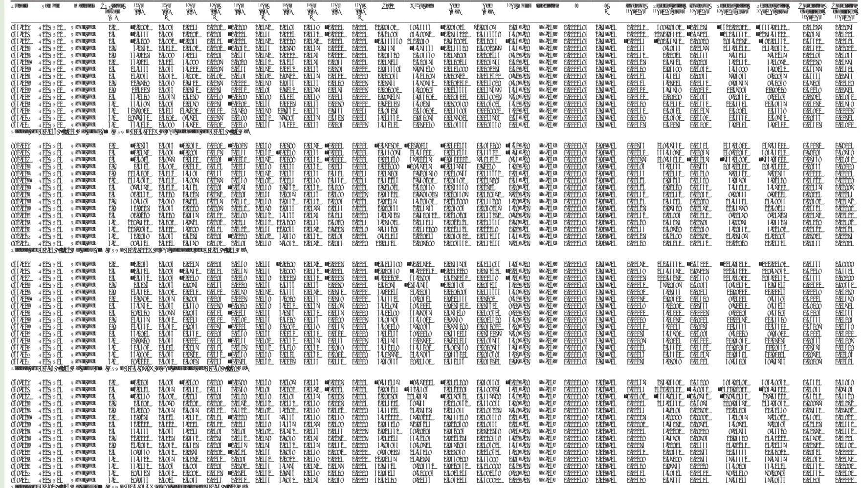
GEOSPHERE | Volume 17 | Number 1 Cosca et al. | Quaternary basalts associated with the Anatolia-Arabia-Africa triple junctionTABLE 1. WHOLE-ROCK MAJOR AND TRACE ELEMENT DATA
Sample: R12 OS 01 R12 OS 03 R12 OS 04 R12 OS 05 R12 OS 06 R12 HA 01 R12 HA 02 R12 HA 03 Latitude (°N): 37.015 37.023 37.029 36.905 36.901 36.732 36.732 37.063 Longitude (°E): 36.067 36.078 36.128 35.955 35.945 36.529 36.543 36.621 Rock type: Basanite Basanite Basalt Basalt Basalt Basalt Basalt Basalt
SiO2 45.3 43.5 47.4 48.5 48.2 47.4 47.2 50.2 TiO2 2.82 3.04 2.02 1.8 1.85 2.4 2.44 2.16 Al2O3 15.9 14.4 15.4 15.3 15.1 16.1 15.4 16.5 Fe2O3 11.8 13.4 12.7 12.9 12.9 12.8 13.1 11.6 Cr2O3 0.01 0.05 0.04 0.05 0.05 0.03 0.04 0.03 MnO 0.17 0.18 0.16 0.17 0.17 0.18 0.16 0.16 MgO 7.86 9.34 7.92 8.74 8.62 6.99 8.05 5.59 CaO 8.28 9.92 10.2 9.73 9.71 10.5 9.62 8.33 Na2O 4.56 3.83 3.25 3.26 3.19 3.07 3.51 3.55 K2O 2.41 1.53 0.81 0.6 0.61 0.86 1.19 1.39 P2O5 0.85 1.04 0.36 0.36 0.37 0.4 0.44 0.4 LOI 1.12 0.522 0.482 <0.01 <0.01 0.171 <0.01 0.354 Sum 99.96 100.23 100.26 101.41 100.77 100.73 101.15 99.91 Ag <1 <1 <1 <1 <1 <1 <1 <1 As <30 <30 <30 <30 <30 <30 <30 <30 Ba 275 308 183 184 208 194 287 331 Be <5 <5 <5 <5 <5 <5 <5 <5 Bi <0.1 <0.1 <0.1 <0.1 <0.1 <0.1 <0.1 <0.1 Cd <0.2 <0.2 <0.2 <0.2 <0.2 <0.2 <0.2 <0.2 Ce 78.6 81.6 40.7 48.8 51.1 37.2 45.8 55.8 Co 39.4 44.1 46.3 48.1 48 43.6 47.2 39.4 Cr 140 210 280 310 310 160 230 100 Cs 0.2 0.1 0.4 <0.1 <0.1 <0.1 0.3 0.1 Cu 45 58 50 29 41 54 58 16 Dy 5.23 4.89 4.05 3.84 3.85 4.29 4.5 5.63 Er 2.65 2.16 1.93 1.98 2.03 2.11 2.32 2.92 Eu 2.38 2.56 1.64 1.61 1.62 1.87 1.89 2.04 Ga 19 18 19 19 19 20 21 23 Gd 6.92 7.08 4.83 4.74 4.69 5.14 5.55 6.36 Ge <1 <1 1 1 1 1 1 1 Hf 7 4 3 3 3 3 4 5 Ho 1 0.86 0.76 0.75 0.76 0.81 0.87 1.08 In <0.2 <0.2 <0.2 <0.2 <0.2 <0.2 <0.2 <0.2 La 41.5 41.6 21.1 26.8 28.6 18 22.6 28.2 Li <10 <10 <10 <10 <10 <10 <10 10 Lu 0.33 0.22 0.23 0.23 0.23 0.23 0.28 0.38 Mo 4 3 <2 <2 <2 <2 <2 2 Nb 49 45 16 16 16 17 27 26 Nd 38.2 39.9 20.5 22.6 23.8 21.5 24.8 30.6 Ni 111 150 126 137 144 88 122 33 Pb <5 <5 <5 <5 <5 <5 <5 7 Pr 9.78 10.2 5.05 5.82 6.08 5.01 6.02 7.32 Rb 24.2 15.2 8.1 7.5 6.4 11.4 20 22.7 Sb 0.2 <0.1 <0.1 0.1 0.1 0.1 <0.1 0.3 Sc 20 20 23 22 23 25 24 25 Sm 7 7.5 4.5 4.6 4.4 4.6 5.2 6.1 Sn 2 2 1 1 <1 1 2 2 Sr 919 1060 587 556 589 591 649 587 Ta 3.5 2.8 1 1 1.1 1.2 1.8 1.7 Tb 0.96 0.93 0.69 0.68 0.69 0.77 0.8 0.94 Th 5 3.3 2.2 3.7 3.9 2.1 2.2 4.4 Tl <0.5 <0.5 <0.5 <0.5 <0.5 <0.5 <0.5 <0.5 Tm 0.36 0.27 0.27 0.28 0.26 0.28 0.3 0.4 U 1.6 1.12 0.63 0.88 0.64 0.67 0.73 1.07 V 178 187 197 191 200 229 215 217 W <1 <1 <1 <1 <1 <1 <1 <1 Y 25 21.9 18.9 18.8 18.8 20.3 22 27.7 Yb 2.2 1.7 1.6 1.6 1.6 1.7 1.9 2.5 Zn 92 91 111 106 109 103 97 102 Zr 284 180 113 110 109 118 150 190
Note: Major elements are in weight percent, and trace elements are in parts per million. LOI—loss on ignition.
Downloaded from http://pubs.geoscienceworld.org/gsa/geosphere/article-pdf/17/1/69/5217740/69.pdf by guest
and one ion counter (36Ar). Following data acqui-sition of 10 min, time zero intercepts were fit to the data (using parabolic and/or linear best fits) and corrected for backgrounds, detector inter-calibrations, and nucleogenic interferences. The mass spectrometer computer program written by A. Deino of the Berkeley Geochronology Center was used for data acquisition, age calculations, and plotting. All 40Ar/39Ar ages reported in Table 2 are referenced to an age of 28.201 ± 0.046 Ma for the Fish Canyon sanidine (Kuiper et al., 2008), the decay constants of Min et al. (2000), and an atmo-spheric 40Ar/36Ar ratio of 298.56 ± 0.31 (Lee et al., 2006). Laser fusion of >10 individual Fish Canyon Tuff sanidine crystals at each closely monitored position within the irradiation package resulted in neutron flux ratios reproducible to ~0.25% (2σ). Isotopic production ratios were determined from irradiated CaF2 and KCl salts, and the following val-ues were measured for this study: (36Ar/37Ar)
Ca = (2.4 ± 0.05) × 10−4; (39Ar/37Ar)
Ca = (6.59 ± 0.10) × 10−4; and (38Ar/39Ar)
K = (1.29 ± 0.03) × 10−2. Cadmium shield-ing durshield-ing irradiation prevented any measurable (40Ar/39Ar)
K. The 40Ar/39Ar plateau ages (and uncer-tainties) are considered to be the best estimate of the cooling age of the minerals and were calculated from samples if three or more consecutive heating steps released >50% of the total 39Ar and also had statistically (2σ) indistinguishable 40Ar/39Ar ages.
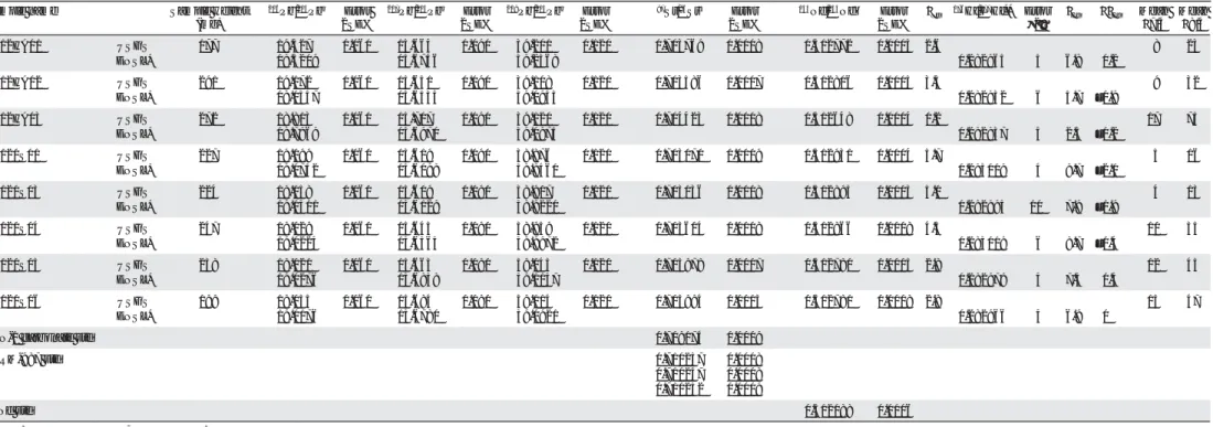
Sr, Nd, Hf, and Pb Isotope Analyses
The analytical techniques used for Pb-Sr-Nd isotopic systematics on whole-rock powders at the USGS were similar to those reported by Tat-sumoto and Unruh (1976) and more recently by Premo and Loucks (2000) and Premo and Taylor (2010). The whole-rock powders were dissolved in 7 mL per fluoroalkoxy TeflonTM vials with ultrapure concentrated HF + HNO3 while heating to ~150 °C on a hot plate for at least 5 d. Lead was extracted from the dissolved effluent using AG1-X8 anion- exchange resin in Teflon columns and a very dilute HBr medium. The Pb laboratory contamination (blank) varied between 60 and 300 pg during the analytical session. Strontium and rare earth elements (REEs)
were separated from the rest of the sample using a 30-mL-volume cation-exchange column (Birck and Allégre, 1978), while Sm was separated from Nd using the α-isobutyric method of Lugmair et al. (1975). Sr and Nd blanks were less than 300 pg each.
Pb, Sr, and Nd isotopic measurements were conducted using a Triton™ (Thermo-Fisher Scien-tific) nine-collector mass spectrometer, which was operated with a 10 kV acceleration voltage and 1011 Ω resistors for the Faraday cups. Pb residues were redissolved in H3PO4 and loaded onto single Re filaments. The measured Pb isotopic ratios were corrected using the algorithms and programming of Ludwig (1980, 1985) for laboratory blanks with measured compositions of 206Pb/204Pb = 19.34 ± 0.53, 207Pb/204Pb = 15.53 ± 0.08, and 208Pb/204Pb = 38.11 ± 0.20, and instrumental mass fractionation (0.08% ± 0.03% per a.m.u.) as determined from multiple runs of the NIST Pb standards SRM-981 and SRM-982.
Between 500 and 1000 ng aliquots of Sr and Nd were loaded separately on outgassed Re fila-ments with a Ta2O5 activator. Within-run 1 standard error (SE) values for conventionally fractionation- corrected isotope ratios using accepted 88Sr/86Sr = 8.375209 typically were ~0.0004% for 87Sr/86Sr and ~0.002% for 84Sr/86Sr in unspiked samples. Unspiked NIST SrCO3 standard SRM-987 was run after each five unknowns, and its average value was used to determine a normalization factor (F) for measured 87Sr/86Sr values as F = (87Sr/86Sr
Measured)/0.710248. The long-term weighted average for the NIST-corrected 87Sr/86Sr value in the USGS carbonate standard EN-1 (giant clam shell) was 0.709176 ± 0.000002 (n = 31, mean square of weighted deviates [MSWD] = 0.82, probability of fit = 0.74). Measured 143Nd/144Nd data were normalized to 146Nd/144Nd = 0.7219 and mon-itored for instrumental bias using the JNd-1 Nd standard (Tanaka et al., 2000). A mean 143Nd/144Nd value of 0.512087 ± 0.00006 (2SE%) was obtained during the same runs, and the average of two JNdi-1 analyses was 0.512085 ± 0.0006 (2SE%).
Hf and duplicate Pb isotope analyses were per-formed at the Ecole Normale Supérieure in Lyon (ENSL), France, on the same whole-rock powders as those used for USGS chemical and isotopic analyses. In this case, an ~600 mg aliquot of whole-rock powder was leached in high-purity 6 M HCl in
stages alternating between heating to 125 °C and ultrasonication. The total duration of leaching was 50 min. The leachate was decanted, and the residue was washed repeatedly in ultrapure water before
digestion in double-distilled concentrated HNO3
and HF in proportions of 1:3. After evaporation, Hf was leached from the digested residue using high-purity concentrated HF and separated first from the remaining sample matrix and then from Ti using a two-stage chromatographic procedure (Blichert-Toft et al., 1997). The Ca-Mg fluoride pre-cipitate remaining after the HF-leaching step was dissolved in double-distilled 6 M HCl, evaporated to dryness, and then converted to bromides. Pb was separated from this solution on a 500 μL AG1-X8 anion-exchange column using dilute HBr to elute the sample matrix and 6 M HCl to collect the Pb.
Isotopic analyses were performed at ENSL on a Nu Plasma 500 HR multiple-collector–inductively coupled plasma–mass spectrometer. Groups of two to four Hf isotope analyses were bracketed by analyses of the JMC-475 Hf standard. Results were normalized for instrumental mass fractionation using an exponential law relative to 179Hf/177Hf = 0.7325. The JMC-475 Hf standard run in alternation in the session with the unknowns yielded 176Hf/177Hf = 0.282158 ± 0.000004 (2 standard deviation [sd];
n = 11). Pb was analyzed using Tl doping (5 ppb)
and sample-standard bracketing (White et al., 2000), wherein the NIST 981 Pb standard was run sys-tematically after every second sample. Analyses were normalized to the values of Eisele et al. (2003). External 2σ reproducibility of 206Pb/204Pb, 207Pb/204Pb, and 208Pb/204Pb was ±100–200 ppm (or 0.01%–0.02%), while that of 207Pb/206Pb and 208Pb/206Pb was ±50 ppm (or 0.005%). Internal run errors on all Pb isotope ratios were better than the external reproducibility. Hf and Pb blanks were <20 pg. The Sr, Nd, Hf, and Pb isotope data are listed in Table 3.
■
RESULTS
Petrography and Rock Geochemistry
Petrographic inspection of the samples revealed fresh basalts with phenocrysts of olivine and
78
Cosca et al. | Quaternary basalts associated with the Anatolia-Arabia-Africa triple junctionGEOSPHERE | Volume 17 | Number 1
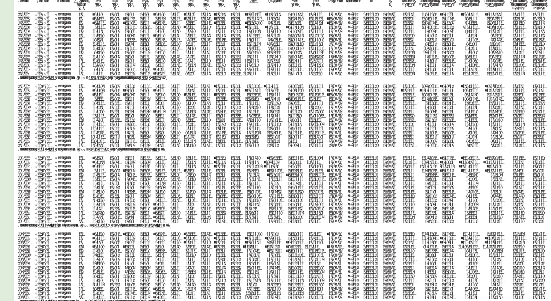
TABLE 2. ANALYTICAL RESULTS OF CO2-LASER INCREMENTAL HEATING 40Ar/39Ar EXPERIMENT
Run_ID Sample Material CO2 laser
power (W) 40Ar (fA) 40Ar (fA) σ 39Ar (fA) 39Ar (fA) σ 38Ar (fA) 38Ar (fA) σ 37Ar (fA) 37Ar (fA) σ 36Ar (fA) 36Ar (fA) σ
Ca/K %40Ar rad Age
(Ma) (Ma)Age
39Ar moles Irradiation J J σ Isochron 36Ar/40Ar Percent initial 36Ar/40Ar error Isochron 39Ar/40Ar Percent initial 39Ar/40Ar error Percent initial 39Ar/36Ar error Correlation coefficient 40Ar/39Ar Correlation coefficient 36Ar/39Ar
865-02A R12 OS01 Whole rock 0.1 –0.1990 0.3983 0.0064 0.2282 –0.0089 0.1472 0.0395 0.1358 –0.0003 0.0015 20.99481 58.33556 –1.994806 72.89487 1.94E-19 DT-15a 0.0000593 2.73E-06 0.00140 589.99580 –0.03173 –3620.00800 –3656.90400 0.14277 0.01876 865-02B R12 OS01 Whole rock 0.3 –0.5635 0.3983 0.2092 0.2293 –0.0015 0.1455 0.1006 0.1361 –0.0001 0.0015 1.624895 93.59872 –0.2735001 0.4346668 6.38E-18 DT-15a 0.0000593 2.73E-06 0.00021 1270.86500 –0.37116 –130.45660 –1273.64100 0.99475 0.03014 865-02C R12 OS01 Whole rock 0.5 –0.4188 0.3992 –0.0834 0.2313 –0.0214 0.1472 0.0109 0.1370 0.0006 0.0015 –0.4435368 140.0848 0.7628916 2.260844 –2.54E-18 DT-15a 0.0000593 2.73E-06 –0.00134 –291.63750 0.19909 293.41070 –391.14530 0.66601 0.10616 865-02D R12 OS01 Whole rock 0.7 6.2740 0.4052 0.1492 0.2282 –0.0942 0.1463 0.0778 0.1367 0.0222 0.0016 1.76375 –5.575563 –0.2543508 0.5992777 4.55E-18 DT-15a 0.0000593 2.73E-06 0.00354 9.68535 0.02377 153.15230 153.18530 0.03511 0.02812 865-02E R12 OS01 Whole rock 0.9 66.9007 0.3989 3.1154 0.2285 0.1656 0.1472 1.1011 0.1374 0.2210 0.0023 1.195619 1.596568 0.0371884 0.0281646 9.50E-17 DT-15a 0.0000593 2.73E-06 0.00330 1.21823 0.04656 7.36034 7.41257 0.12496 0.03966 865-02F R12 OS01 Whole rock 1.1 56.8115 0.4026 4.5999 0.2287 0.1828 0.1460 1.4236 0.1374 0.1865 0.0024 1.047153 2.308473 0.0309245 0.0194735 1.40E-16 DT-15a 0.0000593 2.73E-06 0.00327 1.47525 0.08095 5.02452 5.13971 0.22078 0.06776 865-02G R12 OS01 Whole rock 1.3 25.5533 0.3943 4.3011 0.2287 0.0655 0.1472 1.2142 0.1356 0.0793 0.0020 0.9554494 7.975068 0.0513889 0.0182073 1.31E-16 DT-15a 0.0000593 2.73E-06 0.00308 2.96389 0.16830 5.53888 5.89061 0.36677 0.14503 865-02H R12 OS01 Whole rock 1.5 15.9954 0.3941 3.1890 0.2382 0.0384 0.1482 0.9701 0.1367 0.0520 0.0019 1.029836 3.625197 0.019722 0.0231411 9.72E-17 DT-15a 0.0000593 2.73E-06 0.00323 4.35154 0.19934 7.86866 8.28867 0.35664 0.17733 865-02I R12 OS01 Whole rock 1.7 12.7708 0.3939 2.7501 0.2277 0.0100 0.1478 0.9564 0.1364 0.0408 0.0017 1.17764 5.579742 0.0281051 0.0256919 8.38E-17 DT-15a 0.0000593 2.73E-06 0.00316 5.27115 0.21530 8.83757 9.31968 0.37196 0.20418 865-02J R12 OS01 Whole rock 1.9 11.5117 0.3935 2.0762 0.2274 0.0142 0.1485 0.7251 0.1377 0.0373 0.0017 1.182981 4.099094 0.0246533 0.0337677 6.33E-17 DT-15a 0.0000593 2.73E-06 0.00321 5.74768 0.18032 11.47894 11.89229 0.31239 0.17706 865-02K R12 OS01 Whole rock 2.5 36.2308 0.3947 2.5178 0.2269 –0.0198 0.1488 1.4024 0.1358 0.1135 0.0021 1.887067 6.956182 0.1086014 0.0338917 7.68E-17 DT-15a 0.0000593 2.73E-06 0.00312 2.19198 0.06946 9.08431 9.21695 0.17906 0.05961 865-02L R12 OS01 Whole rock 3.0 33.6497 0.3994 2.1678 0.2274 –0.0290 0.1466 1.1017 0.1356 0.1079 0.0021 1.722307 4.68274 0.0788589 0.0386806 6.61E-17 DT-15a 0.0000593 2.73E-06 0.00319 2.32360 0.06440 10.56405 10.68537 0.16072 0.05739 865-02M R12 OS01 Whole rock 4.0 527.8910 0.4254 16.7281 0.2502 0.4728 0.1478 11.7661 0.1364 1.7455 0.0065 2.384175 1.559082 0.0533883 0.0129882 5.10E-16 DT-15a 0.0000593 2.73E-06 0.00330 0.38426 0.03167 1.49924 1.54348 0.23800 0.01127 865-02N R12 OS01 Whole rock 5.0 197.7330 0.4080 8.6706 0.2277 0.2398 0.1460 7.7884 0.1367 0.6527 0.0036 3.045531 1.930875 0.0477925 0.0145795 2.64E-16 DT-15a 0.0000593 2.73E-06 0.00328 0.59690 0.04381 2.63661 2.68751 0.19555 0.02706 865-02O R12 OS01 Whole rock 6.0 66.3060 0.3998 3.3720 0.2290 0.1238 0.1466 3.5221 0.1353 0.2185 0.0027 3.542323 2.270049 0.0484556 0.0295538 1.03E-16 DT-15a 0.0000593 2.73E-06 0.00327 1.40173 0.05081 6.82604 6.91601 0.16517 0.03800 Plateau age = 0.046 ± 0.013 Ma, steps A–O, MSWD = 0.6, 100% of 39Ar. Integrated age = 0.04 ± 0.2 Ma.
882-02A R12 OS03 Whole rock 0.1 –0.1766 0.3935 –0.1841 0.2290 –0.1907 0.1458 0.0788 0.1370 –0.0013 0.0015 –1.471781 –127.8145 –0.1312344 0.3842189 –5.61E-18 DT-15c 0.0000585 2.91E-06 0.00763 249.37440 1.04314 255.13900 167.35210 0.30072 0.78014 882-02B R12 OS03 Whole rock 0.3 –0.1670 0.3985 –0.1885 0.2307 0.0553 0.1460 –0.0238 0.1364 –0.0004 0.0015 0.4349875 25.36001 0.0240664 0.344612 –5.75E-18 DT-15c 0.0000585 2.91E-06 0.00250 435.53870 1.12857 268.21940 384.35140 0.79295 0.48749 882-02C R12 OS03 Whole rock 0.5 –0.5906 0.3977 0.0310 0.2293 –0.0061 0.1472 0.0099 0.1350 –0.0010 0.0015 1.104068 47.02257 –0.9600012 7.404042 9.45E-19 DT-15c 0.0000585 2.91E-06 0.00177 159.34140 –0.05247 –743.03890 –753.96020 0.17359 0.03830 882-02D R12 OS03 Whole rock 0.7 1.6306 0.3992 0.1250 0.2406 0.1043 0.1469 0.0444 0.1361 0.0065 0.0015 1.222999 –18.37057 –0.2567734 0.72039 3.81E-18 DT-15c 0.0000585 2.91E-06 0.00396 34.26463 0.07663 194.12610 194.06000 0.08645 0.09009 882-02E R12 OS03 Whole rock 0.9 105.5190 0.4052 3.4394 0.2456 0.2053 0.1472 1.1365 0.1364 0.3513 0.0033 1.137094 0.7295749 0.0239766 0.0334662 1.05E-16 DT-15c 0.0000585 2.91E-06 0.00333 1.02341 0.03259 7.15521 7.20753 0.12200 0.02014 882-02F R12 OS03 Whole rock 1.1 133.5860 0.4052 4.6887 0.2277 0.1648 0.1482 2.1145 0.1358 0.4361 0.0035 1.552266 2.738291 0.083582 0.0257184 1.43E-16 DT-15c 0.0000585 2.91E-06 0.00326 0.85236 0.03509 4.86783 4.92319 0.15120 0.02218 882-02G R12 OS03 Whole rock 1.3 97.5470 0.4052 3.5623 0.2285 –0.0675 0.1458 1.7662 0.1361 0.3189 0.0026 1.706925 2.609439 0.0765559 0.02706 1.09E-16 DT-15c 0.0000585 2.91E-06 0.00326 0.92628 0.03651 6.43041 6.47010 0.11437 0.02897 882-02H R12 OS03 Whole rock 1.5 81.0361 0.4019 2.3027 0.2272 0.1086 0.1463 1.2947 0.1356 0.2699 0.0027 1.936204 0.7785817 0.0293587 0.0418571 7.02E-17 DT-15c 0.0000585 2.91E-06 0.00332 1.11432 0.02840 9.88445 9.92223 0.09006 0.02233 882-02I R12 OS03 Whole rock 1.7 58.4496 0.3949 1.7006 0.2267 0.2541 0.1469 0.9442 0.1350 0.1895 0.0024 1.91237 3.429692 0.1262988 0.0543298 5.18E-17 DT-15c 0.0000585 2.91E-06 0.00323 1.44106 0.02908 13.35514 13.39853 0.08391 0.02372 882-02J R12 OS03 Whole rock 1.9 40.9107 0.3946 1.0119 0.2287 0.0030 0.1478 0.8543 0.1377 0.1343 0.0023 2.908663 2.235736 0.096886 0.0869057 3.08E-17 DT-15c 0.0000585 2.91E-06 0.00327 1.97409 0.02471 22.64778 22.69254 0.06623 0.02081 882-02K R12 OS03 Whole rock 2.5 90.8228 0.4019 2.8557 0.2310 0.1398 0.1452 3.5366 0.1374 0.3035 0.0029 4.267627 0.7309502 0.0249283 0.0356171 8.71E-17 DT-15c 0.0000585 2.91E-06 0.00332 1.04895 0.03140 8.11379 8.15727 0.10571 0.02301 882-02L R12 OS03 Whole rock 3.0 209.7410 0.4080 5.8725 0.2282 0.1145 0.1460 10.5188 0.1356 0.6919 0.0043 6.173904 2.146035 0.0822423 0.0246646 1.79E-16 DT-15c 0.0000585 2.91E-06 0.00328 0.65075 0.02795 3.89875 3.94307 0.15028 0.01492 882-02M R12 OS03 Whole rock 4.0 207.9860 0.4111 5.9189 0.2414 0.2402 0.1466 12.9865 0.1370 0.7017 0.0038 7.564285 0.0650099 0.0024524 0.022149 1.80E-16 DT-15c 0.0000585 2.91E-06 0.00335 0.58728 0.02839 4.09350 4.12592 0.12621 0.01625 882-02N R12 OS03 Whole rock 5.0 51.1968 0.3946 1.4274 0.2285 –0.2209 0.1482 3.8559 0.1361 0.1693 0.0024 9.315146 2.228134 0.0858401 0.0630536 4.35E-17 DT-15c 0.0000585 2.91E-06 0.00327 1.62499 0.02780 16.07387 16.11886 0.07813 0.02274 882-02O R12 OS03 Whole rock 6.0 88.5523 0.4026 2.3478 0.2390 0.0595 0.1458 7.5930 0.1370 0.2933 0.0028 11.15513 2.187189 0.0886661 0.0432335 7.16E-17 DT-15c 0.0000585 2.91E-06 0.00328 1.06151 0.02642 10.22829 10.26303 0.08445 0.01904 Plateau age = 0.05 ± 0.02 Ma, steps A–O, MSWD = 1.0, 100% of 39Ar. Integrated age = 0.06 ± 0.03 Ma.
866-02A R12 OS04 Whole rock 0.1 –0.2946 0.3985 0.1267 0.2293 0.0669 0.1455 –0.0189 0.1370 –0.0017 0.0015 –0.5066588 –70.03711 0.1765784 0.6053953 3.86E-18 DT-15a 0.0000593 2.73E-06 0.00570 162.34530 –0.43012 –225.95050 –202.02490 0.24564 0.49888 866-02B R12 OS04 Whole rock 0.3 –0.4315 0.3985 –0.3751 0.2414 0.1357 0.1455 0.1999 0.1350 –0.0014 0.0015 –1.808358 –4.101151 –0.0051118 0.1740613 –1.14E-17 DT-15a 0.0000593 2.73E-06 0.00349 136.55670 0.87007 112.54220 119.37950 0.62059 0.55505 866-02C R12 OS04 Whole rock 0.5 –0.6462 0.3983 –0.1068 0.2293 0.0249 0.1469 0.1007 0.1361 –0.0007 0.0015 –3.200282 65.17983 0.4271061 1.101338 –3.26E-18 DT-15a 0.0000593 2.73E-06 0.00117 210.54270 0.16548 223.13910 294.12330 0.65443 0.08088 866-02D R12 OS04 Whole rock 0.7 0.6176 0.3936 0.9875 0.2456 0.0229 0.1463 0.4446 0.1356 0.0079 0.0016 1.52875 –273.3736 –0.185483 0.083154 3.01E-17 DT-15a 0.0000593 2.73E-06 0.01251 67.19597 1.59844 68.41560 32.76143 0.20622 0.88341 866-02E R12 OS04 Whole rock 0.9 26.3600 0.3992 2.1260 0.2502 0.2378 0.1472 2.4544 0.1370 0.0750 0.0021 3.921166 16.20966 0.2181896 0.0454644 6.48E-17 DT-15a 0.0000593 2.73E-06 0.00281 3.17464 0.08056 11.88202 12.11066 0.20249 0.06079 866-02F R12 OS04 Whole rock 1.1 42.7790 0.3957 2.7894 0.2285 0.1027 0.1469 5.2919 0.1364 0.0749 0.0020 6.445504 49.29623 0.8213333 0.07292 8.50E-17 DT-15a 0.0000593 2.73E-06 0.00170 2.89401 0.06508 8.26013 8.65385 0.30024 0.03579 866-02G R12 OS04 Whole rock 1.3 34.4750 0.3935 2.6468 0.2279 –0.0808 0.1469 4.2252 0.1367 0.0497 0.0019 5.424875 58.50023 0.8275052 0.076614 8.07E-17 DT-15a 0.0000593 2.73E-06 0.00139 4.02880 0.07665 8.70250 9.45264 0.39199 0.03715 866-02H R12 OS04 Whole rock 1.5 29.1529 0.3977 2.9845 0.2414 –0.0143 0.1455 3.0736 0.1361 0.0367 0.0018 3.500699 63.77857 0.676168 0.0598524 9.10E-17 DT-15a 0.0000593 2.73E-06 0.00121 5.23101 0.10227 8.21186 9.54285 0.51084 0.04333 866-02I R12 OS04 Whole rock 1.7 23.5637 0.3951 2.1264 0.2310 0.0691 0.1466 2.3108 0.1356 0.0289 0.0017 3.694786 64.65821 0.77768 0.0906409 6.48E-17 DT-15a 0.0000593 2.73E-06 0.00118 6.25070 0.09015 11.00672 12.43308 0.46655 0.04086 866-02J R12 OS04 Whole rock 1.9 24.6632 0.3951 1.9935 0.2274 –0.0204 0.1469 2.0992 0.1358 0.0357 0.0016 3.581169 57.88866 0.7773099 0.0951822 6.08E-17 DT-15a 0.0000593 2.73E-06 0.00141 5.00133 0.08075 11.53365 12.36501 0.36297 0.04448 866-02K R12 OS04 Whole rock 2.5 35.0803 0.3943 2.4561 0.2293 0.1668 0.1463 2.2040 0.1350 0.0620 0.0019 3.052636 48.00169 0.7440035 0.0760077 7.49E-17 DT-15a 0.0000593 2.73E-06 0.00174 3.33790 0.06995 9.41229 9.85900 0.30016 0.04021 866-02L R12 OS04 Whole rock 3.0 17.8728 0.3933 1.1112 0.2414 –0.1334 0.1482 1.0632 0.1367 0.0356 0.0017 3.255754 41.27701 0.7205034 0.1686744 3.39E-17 DT-15a 0.0000593 2.73E-06 0.00197 5.29124 0.06212 21.85841 22.27275 0.19646 0.04187 866-02M R12 OS04 Whole rock 4.0 41.6482 0.4016 2.2147 0.2406 0.1617 0.1452 2.3049 0.1361 0.0939 0.0020 3.542149 33.35292 0.6807369 0.0819754 6.75E-17 DT-15a 0.0000593 2.73E-06 0.00223 2.35420 0.05312 10.91830 11.08542 0.17673 0.03618 866-02N R12 OS04 Whole rock 5.0 34.8882 0.3935 1.0721 0.2332 –0.1648 0.1458 2.0525 0.1361 0.0902 0.0019 6.517772 23.57856 0.8336213 0.1949683 3.27E-17 DT-15a 0.0000593 2.73E-06 0.00256 2.43421 0.03067 21.83405 21.91113 0.08725 0.02393 866-02O R12 OS04 Whole rock 6.0 19.2220 0.3941 0.5807 0.2236 –0.0715 0.1460 1.0127 0.1353 0.0531 0.0019 5.938656 18.14481 0.652436 0.2832723 1.77E-17 DT-15a 0.0000593 2.73E-06 0.00274 4.17858 0.03016 38.63094 38.74754 0.08187 0.02605 Plateau age = 0.75 ± 0.06 Ma, steps F–O, MSWD = 0.5, 87.9% of 39Ar. Integrated age = 0.68 ± 0.08 Ma.
869-02A R12 OS05 Whole rock 0.1 –0.2083 0.3996 –0.0689 0.2298 –0.0799 0.1469 0.1687 0.1356 –0.0007 0.0015 –8.351647 –9.571015 –0.0316088 0.9594585 –2.10E-18 DT-15b 0.0000599 1.02E-06 0.00367 274.96580 0.33199 383.81590 386.39860 0.36523 0.34869 869-02B R12 OS05 Whole rock 0.3 –0.0303 0.3937 0.1361 0.2456 0.0768 0.1485 0.1190 0.1370 –0.0006 0.0015 2.984234 –540.4586 0.1320194 0.5388276 4.15E-18 DT-15b 0.0000599 1.02E-06 0.02145 1320.10500 –4.48831 –1311.90800 –294.73110 0.13935 0.97494 869-02C R12 OS05 Whole rock 0.5 –0.1549 0.3992 0.2166 0.2293 0.0508 0.1469 0.1384 0.1367 0.0007 0.0015 2.181793 213.9376 –0.1678625 0.3537798 6.60E-18 DT-15b 0.0000599 1.02E-06 –0.00382 –363.70530 –1.39742 –278.61460 277.66220 0.65232 0.65528 869-02D R12 OS05 Whole rock 0.7 0.6190 0.3979 0.2290 0.2290 0.0572 0.1452 0.1430 0.1358 0.0007 0.0015 2.133006 68.745 0.2038362 0.3549853 6.98E-18 DT-15b 0.0000599 1.02E-06 0.00105 245.16360 0.36975 118.94370 256.86850 0.88877 0.14172 869-02E R12 OS05 Whole rock 0.9 23.0189 0.3957 2.4857 0.2502 0.3422 0.1482 4.0281 0.1358 0.0602 0.0019 5.535125 24.17407 0.245844 0.0395207 7.58E-17 DT-15b 0.0000599 1.02E-06 0.00254 3.70685 0.10780 10.23096 10.60638 0.27431 0.07792 869-02F R12 OS05 Whole rock 1.1 40.8275 0.4026 4.0461 0.2414 –0.1009 0.1466 7.4636 0.1358 0.0469 0.0018 6.302101 67.98202 0.7534058 0.0485558 1.23E-16 DT-15b 0.0000599 1.02E-06 0.00107 4.19999 0.09891 6.05947 7.23922 0.54815 0.03821 869-02G R12 OS05 Whole rock 1.3 42.2212 0.4021 4.1013 0.2301 0.1044 0.1458 3.5467 0.1377 0.0399 0.0018 2.955068 72.86263 0.8228698 0.049544 1.25E-16 DT-15b 0.0000599 1.02E-06 0.00091 4.75171 0.09706 5.69706 7.29486 0.62517 0.03351 869-02H R12 OS05 Whole rock 1.5 33.3455 0.3936 3.0064 0.2394 0.0495 0.1482 2.5732 0.1356 0.0354 0.0017 2.925451 69.28285 0.842996 0.0710758 9.16E-17 DT-15b 0.0000599 1.02E-06 0.00103 5.02280 0.09009 8.05733 9.34628 0.50770 0.03442 869-02I R12 OS05 Whole rock 1.7 22.1001 0.4007 1.9432 0.2274 0.0642 0.1478 1.7849 0.1374 0.0272 0.0017 3.140265 64.32684 0.8026274 0.1009449 5.92E-17 DT-15b 0.0000599 1.02E-06 0.00119 6.75794 0.08785 11.85508 13.40222 0.46792 0.04103 869-02J R12 OS05 Whole rock 1.9 26.2850 0.3952 1.4617 0.2296 –0.0557 0.1475 2.0462 0.1367 0.0462 0.0018 4.786944 48.49703 0.9572833 0.1585924 4.46E-17 DT-15b 0.0000599 1.02E-06 0.00173 4.21903 0.05553 15.80230 16.21657 0.22712 0.03391 869-02K R12 OS05 Whole rock 2.5 38.8438 0.3941 1.0773 0.2290 –0.0616 0.1466 2.7869 0.1358 0.0982 0.0020 8.848017 25.43058 1.007848 0.2268625 3.28E-17 DT-15b 0.0000599 1.02E-06 0.00250 2.29561 0.02766 21.34433 21.41920 0.08623 0.02101 869-02L R12 OS05 Whole rock 3.0 34.4600 0.3937 0.6072 0.2262 0.1995 0.1460 2.2921 0.1348 0.1006 0.0021 12.91457 13.71775 0.8569099 0.346989 1.85E-17 DT-15b 0.0000599 1.02E-06 0.00289 2.37199 0.01755 37.43442 37.47447 0.04861 0.01470 869-02M R12 OS05 Whole rock 4.0 44.1550 0.3996 0.4985 0.2293 0.0781 0.1463 4.4776 0.1370 0.1377 0.0024 30.73525 8.186352 0.8029462 0.4148899 1.52E-17 DT-15b 0.0000599 1.02E-06 0.00308 1.97764 0.01118 46.48094 46.50524 0.03362 0.00891 869-02N R12 OS05 Whole rock 5.0 19.6527 0.3940 0.2981 0.2307 –0.0726 0.1452 2.7736 0.1358 0.0609 0.0019 31.84155 9.319985 0.6806063 0.5891369 9.09E-18 DT-15b 0.0000599 1.02E-06 0.00304 3.69606 0.01501 78.25239 78.28796 0.03332 0.01390 869-02O R12 OS05 Whole rock 6.0 29.8533 0.3923 0.3946 0.2243 0.0130 0.1463 4.7840 0.1374 0.0939 0.0019 41.50508 8.12366 0.6831044 0.4398811 1.20E-17 DT-15b 0.0000599 1.02E-06 0.00308 2.47553 0.01304 57.66066 57.68363 0.03083 0.01210 Plateau age = 0.81 ± 0.06 Ma, steps F–O, MSWD = 0.4, 85.3% of 39Ar. Integrated age = 0.74 ± 0.07 Ma.
(continued)
Downloaded from http://pubs.geoscienceworld.org/gsa/geosphere/article-pdf/17/1/69/5217740/69.pdf by guest