©BEYKENT UNIVERSITY
THE IMPORTANCE OF HYDROGEOLOGY
ASSESSMENTS FOR AGRICULTURAL WATER
DEMAND: A CASE STUDY FROM SOUTHWEST
TURKEY
Ayşen DAVRAZ* & Remzi KARAGÜZEL**
*Süleyman Demirel University,Department of Geological Eng. Isparta**İstanbul Technical University, Department of Geological Eng, İstanbul [email protected]
Received: 18 March 2008, Accepted: 07 April 2008
ABSTRACT
The study area is situated in the Lake District of southwest Turkey. The Eğirdir and Burdur lakes are the most important ones in this region due to their size and water potential. The extensive Atabey and Keçiborlu plains that are located between these lakes receive irrigation water both from Eğirdir Lake and from groundwaters. Throughout this region, the demand for irrigation water has increased steadily over recent years. The aim of this work was to investigate the water quality and potential across this region, using hydrogeological, hydrological and hydrogeochemical techniques.
The hydrochemical and isotopic characteristics of both the lakes and the groundwater of the study area were determined. Eğirdir lake and the groundwaters of the Atabey and Keçiborlu plains are Ca+2-Mg+2-HCO3- type waters, whereas Burdur lake contains Na+-SO4-2- (Cl-)- HCO3- type waters. The 518O, 52H and 3H isotopic contents indicate that both the lake waters and the groundwater in the aquifers between these lakes are young and of meteoric origin. Groundwater is the most important sources for supplying future enhanced demands for irrigation water in this region, from the point of view of water quality and availability.
TARIMSAL SU TALEBİNİN
DEĞERLENDİRİLMESİNDE
HİDROJEOLOJİNİN ÖNEMİ: GÜNEYBATI
TÜRKİYE'DEN BİR ÖRNEK
ÖZET
Çalışma alanı Türkiye'nin güneybatısında Göller Bölgesinde bulunmaktadır. Bölgede Eğirdir ve Burdur gölleri, boyutları ve su potansiyellerinden dolayı önemli göller arasında yeralmaktadır. Sözkonusu göller arasında bulunan Atabey ve Keçiborlu ovalarının sulama suyu ihtiyacı Eğirdir gölü suyu ve yeraltısularından karşılanmaktadır. Yörede sulama suyu ihtiyacı sürekli olarak artmaktadır. Bu çalışmanın amacı, hidrojeolojik, hidrolojik ve hidrojeokimyasal araştırma yöntemlerini kullanarak bölgenin su potansiyeli ve kalitesinin araştırılmasıdır.
Eğirdir ve Burdur göllerinin suları ile bölgedeki yeraltısularının hidrokimyasal ve izotop karakteristikleri belirlenmiştir. Eğirdir gölü ile Atabey ve Keçiborlu ovalarında bulunan yeraltısuları Ca+2-Mg+2-HCO3- tipi suları temsil ederken, Burdur gölü Na+SO42 (Cl) HCO3 tipi sulardan oluşmaktadır. 518O -52H ilişkisi ile 3H değerleri araştırma alanındaki yüzey ve yeraltısularının oldukça genç ve meteorik kökenli olduğunu göstermektedir. Yeraltısuları, çalışma alanında, kalitesi ve potansiyeli açısından, artan sulama suyu talebinin karşılanması için en önemli kaynağı oluşturmaktadır.
1. INTRODUCTION
The Lake District of Turkey is one of the most water-rich regions of the country. This area is located within the Isparta Angle, a tectonic zone in which several structurally controlled lakes have been developed. In the region, many fresh and brine lakes such as Eğirdir (fresh), Beyşehir (fresh), Burdur (brine), Akşehir (brackish), Acı (brackish) are present and large aquifers also occur between the lakes, including the Isparta, Atabey, Keçiborlu, Gelendost, Yalvaç and Burdur plains, all of which have stimulated intense agricultural activity. The surface and groundwater resources have been utilized for various purposes, including household and industrial uses, irrigation, hydroelectric energy production and tourism. This study concentrates on the Eğirdir and Burdur lakes and the alluvial plains separating these lakes [1] (Figure 1). The distance between the Eğirdir and Burdur lakes is 50 km. The alluvial plains located between the lakes have important groundwater potential, especially for irrigation purposes.
Figure 1. Location map [1]
At present irrigation water supplied from the Eğirdir Lake is being up to other uses in the region. Furthermore, new irrigation areas are planned that with use the Eğirdir lake water. Thus, in the future increased demand for irrigation water is likely to lead to an increasingly important role for groundwater supply. The quality and availability of groundwaters are especially important from the point of view of agricultural activities. Groundwater quality is influenced by many factors such as water-rock interactions, contaminating
elements, urban effect, human activity, salt water intrusion, etc. Water resources assessments, such as this study, involve integration of data from several aqueous sub-sectors such as surface and groundwater quality, the hydrogeological connections between basins, regional hydrology, aquifer parameters and groundwater flow directions. In the study area, investigation of the hydrogeological relations between the plains and lakes is clearly important. Eğirdir Lake is a shallow, structurally controlled lake in the Taurus karst belt that formed within highly karstified Mesozoic carbonate rock masses with mainly subsurface connections to the adjacent surface and groundwater basins. Burdur Lake is positioned in an intramountane setting. It has received much more water than Eğirdir and its hydrologic balance became positive during the Early Pleistocene; therefore the waters of the lake could flow over the local thresholds in the northeast Atabey plain. However, the increasing rate of tectonic subsidence led to deepening of the lake and its eventual isolation, and increased evaporation then resulted in more brine- rich waters [2]. Commonly, in closed saline lakes, all groundwater and surface water flows converge towards the lake, and there is no surface or groundwater outlet [3].
2. METHODS
The following techniques have been employed to achieve the aims of this study. The basis of any hydrogeological investigation is a thorough understanding of the underlying geology. Thus the geological setting of the region was established from numerous previous studies. Aquifer units were then identified according to the hydrogeological properties of the litho-stratigraphic units described. The hydraulic conductivity and transmissivity of aquifers were then determined by pumping tests carried out in different wells in the study area. A piezometric map was prepared to elucidate the hydraulic relations between the aquifers and the lakes. Furthermore, hydro-chemical and isotopic characteristics of the surface and groundwaters were investigated. For this purpose, the analyses of Eğirdir and Burdur lake waters previously made by the State Hydraulic Works agency (DSI) were reevaluated. In addition, groundwater samples were collected for analyses of their major chemical and isotopic characteristics. Samples were safely stored in two polyethylene bottles. One of the bottles was acidified with suprapure HNO3 for determination of cations and another was kept unacidified for the anion analyses. PH and electrical conductivity (EC) were measured in the field using HACH DR 2000 EC meter instrument. The major chemical constituents were analyzed by spectrophotometer and the HCO3 was determined volumetrically and SO4 by the gravimetric method in the State Hydraulic Works laboratory. Analyses of 18O, 2H and 3H in six samples were performed at in the GSF -Institute of Hydrology in Munich, Germany using a Europa Scientific ANCA-GSL and GEO 20-20 IRMS.
3. GEOLOGY
In the study area, previous geological investigations had been made by different researchers [4,5,6,7,8,9,10]. The Menteşe Dolomite (Upper Triassic), Alakilise Limestone (Jurassic), Davraz Limestone (Upper Jurassic), Kayıköy Formation (Lower-Mid Eocene), Gönen Conglomerate (Oligocene), Gölcük Formation (Lower Pliocene), and Quaternary alluvium and alluvial fans are the autochthonous units in the study area while the allochthonous units consist of the Ispartaçay Formation (Triassic) and the Isparta Ophiolitic Complex (Figure 2)
Allochthon:
The Isparta Ophiolitic Complex is composed of diabase, limestone, radiolarite and chert with mixed harzburgite, serpentinite and amphibolite. The emplacement age of the complex is Upper Paleocene- Lower Eocene [8]. The Ispartacay Formation is made up of radiolarites, cherts, spilitic and basaltic pillow lavas, thin bedded limestones, sandstones, mudstones and volcanosedimentary rock components (Middle-Upper Triassic). The emplacement age of this formation is Upper Cretaceous.
Autochthon:
The Menteşe dolomitic limestones are frequently jointed and very brittle. The Alakilise limestones are also frequently jointed with karstic pockets and are intercalated with cherts. The Davraz limestone is frequently jointed. The Eocene Kayıköy Formation is comprised of sandstones, conglomerate, shale, clayey limestone and cherty limestone. The Gönen conglomerates are polygenic, carbonate-cemented marine deposits, interbedded with limestone. The Gölcük Formation is made up of sandstone, claystone, marl and tuff. The alluvium covers an area of approximately 320 km2. This Quaternary unit consists of gravel, sand, clay and silt and the Alluvial fans consist of a range of materials from large blocks to clay size.
4. HYDROGEOLOGY
Hydrology and Surface Waters
Average annual precipitation in the study area was 571.5 mm for a period of 68 years (1929-1997). According to the Thornthwaite method, the average evaporation value was 295.79 mm. Average temperature of the study area is 11.9 0C [11]. There are no significant perennial streams in the study area. Many seasonal springs are located in the study area; however, long-term data on spring-flows do not exist.
The altitude of Eğirdir Lake is approximately 915 m above sea level, the surface area is maximum 482 km2 and its average depth is 6-7 m. The Eğirdir Lake is recharged by precipitation, surface and groundwater flow. Average precipitation has been determined as
602.82 mm for the lake and surface flow has been measured as 838.82 hm3/year (1966-1995) - [12]. The discharge of the lake is through evaporation, irrigation water, drinking water and the flow through an outlet canal. Apart from this, there are water losses from karstic sink holes in the western border of the lake (Figure 2). Evaporation from the lake surface has been determined by Karagüzel et al (1995) as 504.57 hm3/year (1966-1994). Irrigation water withdrawals have been measured as 53.3 hm3/year (1968-1994). The flow from an outlet canal was 310.33 hm3/year between 1966-1994. Drinking water withdrawals from the lake average 41.5 hm3/year. The annual fluctuation in lake surface level ranges from 30-50 cm and periodical changes can reach up to 3.84 meters. The Eğirdir Lake water is renewed approximately every four years based on the hydrological balance [12].
Burdur Lake, located to the west of Eğirdir Lake, is also a tectonic lake [1]. The lake's average altitude is 850 m above sea level, surface area is about 194 km2 and its average depth is 45 m [13]. The lake is fed by precipitation, as well as by perennial streams, seasonal streams and groundwater discharge. The average annual precipitation around the Burdur Lake was 420.65 mm for a period of 50 years (1950-2000) [14]. The average evaporation from the lake was measured by State Hydraulic Works (1998) as 1330.5 mm [15]. The discharge of the rivers and streams is low and some of them dry up in summer. Burdur Lake has no outlet and thus water loss only occurs through evaporation. The water budget of Burdur Lake was not made because of insufficient recharge and discharge data. Its water is not suitable for any use, due to the high salinity.
Hydrogeological Characteristics of Lithological Units
The Kayıköy Formation has impermeable properties due to the rapid alternation of various sedimentary lithologies. The Ispartacay formation and Isparta ophiolite complex are also considered effectively impermeable while the Gölcük Formation is slightly permeable due to the volcanic gravel and tuff levels which store some groundwater.
The Quaternary alluvium is the most important aquifer. The thickness of alluvium is in the range of 60-210 m around Kılıç village located in the west of the study area (Fig. 2). The aquifer parameters were determined by pumping test carried out in different wells in the study area. In this region, the yield values range between 10 l/sec and 60 l/sec and transmissivity between 3.0 x10⁻³ and 1.5 x10⁻⁴ m2/sec. The hydraulic conductivity ranges from 4.6 x10⁻⁵ -1.0 x10⁻⁶ m/sec.
The average thickness of alluvium is 75 m in the İgdecik area (Fig. 2). The well yields are low (6 l/sec) because the alluvium deposits here are relatively clayey. The alluvium thickness is in the range of 50-190 m in the Gönen area. The yield of the wells here is between 10 l/sec and 50 l/sec. In this area
transmissivity values are between 1.2 x10⁻³ and 3.3 x10⁻⁵ m2/sec. Hydraulic conductivity is between 4.6 x10⁻⁷ and 1.27 x10⁻⁵ m/sec.
In the Senirce area (Fig. 2) the thickness of alluvium is in the range of 80-125 m and well yield average 10-14 l/sec. Here the transmissivity is 2.15 x10⁻⁴ m2/sec and the hydraulic conductivity is 2.16 x10⁻⁶ m/sec.
In the İslamköy area the thickness of alluvium ranges between 30-70 m. The yield of the wells averages 17 l/sec in this region. Some wells draw water from the karstic aquifer under the alluvium deposits. The transmissivity is 2.10 x10⁻⁴ m2/sec. In the Kuleönü area (Fig. 2) the thickness of alluvium is in the range of 60-90 m. The wells in the region have yields of 20-50 l/sec from alluvium and karstic aquifers.
The reliable groundwater potential for the alluvial aquifer below the Atabey plain has been calculated as 32.6 x10⁶ m3/year [16].
The Gönen conglomerates crop out over a wide area (Fig. 3) and have been described as a permeable karstic unit. Wells in the alluvial areas intersect the conglomerates at different depths and this unit varies in thickness across the region. Values of transmissivity (3.3 x10⁻⁵ m2/sec) and hydraulic conductivity (2.17 x10⁻⁷ m/sec) for this unit determined in wells are low in comparison with wells drilled in alluvium.
Most of the limestones in the study area are karstic aquifers due to the solution openings and fractures. Water is supplied from karstic aquifers located at beneath the alluvium in Senirce, Kuleönü and İslamköy. In addition, wells drilled in the limestones olistolith within the Isparta Ophiolite Complex provide water flows of between 29 l/sec and 33 l/sec in the Sevinçbey region. Here transmissivity is 1.30 x10⁻⁴ m2/sec and hydraulic conductivity is 1.57 x10⁻⁶ m/sec.
A water-level map has been prepared for the alluvial aquifers between both lakes (Figure 2). Groundwater discharge to the karstic system below the alluvium near Bayat in the Atabey plain was determined. Groundwater from the alluvial deposits flows towards Burdur Lake in the Keçiborlu plain. Groundwater discharges to autochthonous limestones in the Isparta plain, which is located south of the Atabey plain [11]. Apart from this, groundwater discharge to sinkholes along the western border of the Eğirdir Lake is observed. Groundwater discharge to the limestone aquifer is known across most of the region.
5. HYDROGEOCHEMISTRY
In addition to affecting crop yield and soil conditions, irrigation water quality can influence the needs for fertilizers, the performance and longevity of the irrigation system and the methods of applying water. Therefore, knowledge of irrigation water quality is critical to understanding what management changes are necessary for long-term productivity.
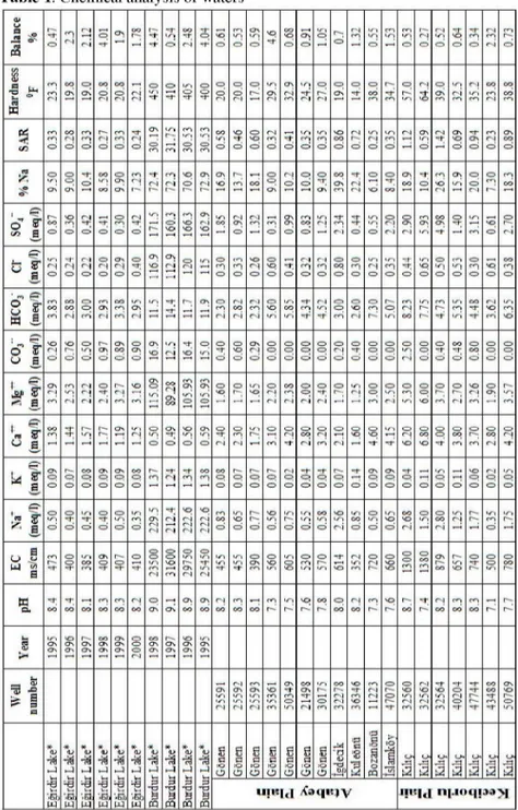
The chemical components of the lakes and groundwater of the study area were analyzed, and the results are given in Table 1. Charge-balance error of the waters is less than 5% which is within the limits of acceptability. Evaluating these findings, the hydrochemistry map was prepared as shown in Figure 3. It was observed that concentrations of Ca+2, Mg+2, Na+ and HCO3- are high in the plains and in Eğirdir Lake. Water of Burdur Lake has very high ion concentrations. The composition of the saline lake depends largely on the original composition of the input water. The high total ion content in the water limits the efficiency of water-rock interaction and absorption [3].
Hardness values, according to the French Hardness Scale, are in the range of 19-22 for Eğirdir Lake, 400-450 for Burdur Lake, 17-38 for Atabey plain and 24-64 for Keçiborlu plain. Electrical conductivity values (EC) are 350-720 |is/cm in the Atabey plain, 500-1380 |is/cm in the Keçiborlu plain, 380-470 |is/cm in the Egirdir Lake, and 23 500-31 600 |s/cm in the Burdur Lake. PH range is 7.1-8.4 for Eğirdir Lake water and groundwaters. PH range of Burdur Lake water is 8.8-9.1. The normal pH range for irrigation water is from 6.5 to 8.4. Abnormally low pH values may cause accelerated irrigation system corrosion. The sodium adsorption ratio (SAR) of irrigation water is generally a good indicator of the sodium status that will occur in the soil. The SAR of Eğirdir Lake and groundwater is between 0.24 - 1.42 and thus is suitable for irrigation water (Table 1).
Table 1. Chemical analysis of waters <n (J a _ J2 # a CO o (N r-1
eN S -r as -I-; T O es -T S •o o O OS un Ö •o -1- •o o Os O cri eN en un cr» LT1 un O eN O eN un O o s ^F en o eN en eN o [Si QJ 1 ^ s ¡ti m m eN eo Os cr OS co CT eN CO O c i es O O ¥ ? o o eN O O M O un OS as es <r¡ •rt cr> es cr-] p cr-oo -F cr r^ fN 3 p os un (S eN un co en eN oo co
%
HO m m O co eS O C"i m CT» o r 1 m en er fS O -1-Os O en iri en m O en m o en OO un O •-O -1 O V©O e^-i en cr¡ f Ö iri m cr¡ un en •o oo cr! eN O cr» r-i ir> Ln m O eN Os O r-i -i Os O SO *-F Os cri m eN O OS oo-cr IV
K Í
o
oí O Os ~t CT oo O Cl-, Cht en es I— es en CS O ••o Os es Os vD en oo cr> o Os CN O 1—• cr» -t; Os co cr-i -F eS eN cr-••-rj cr-T; Os OO er-en •o eN OS in p O O en co 1 Q M S y-o JO
cr -F CT CT O er ÇS O
§
O •-o •o •o Os eS•-o &o g r i Os Os ö S3 cr> íTi fN eN ? O LP cr O eN eN s evi en Os oo os ^ ? 1 f 1 •o O cr r 1 b l îs <Tî eS -F 1=' rs rl CT CT rs| O cas «S O CT o OS as cSí O iri O
O o rO ! Vp CD O 1—• (S en er-cr-oo ö o n O es cr- cr -f cr •¿i O O tr¡ O ir» O o O vq Ö
-rr-' r*, O CP S I oo en eS CO O O en Os CS en en fS os Os O rn (S rvj oo •"i e^j en
es Ö •o OO un "-f m -v es ir» O p en eN •o o o-rn •=: Lri eN oo en iri rf eN •O en m o" f
u ^a •o
r !
o •O O cr un cd¡ o! CI-, os oo o cr OS CT¡ •O a-, r-Inn 1 •O p in O -I-Ö o •-o cr» as CS Ö o o O o o cr> o cr> cr» o o eN cr? O -F O o p cr¡ O O O iri r--l O cr o O -F O co O -F cr oo o¡ o er o cr o Ö t f o, r ! rn eN eS O CN -1-es •O os o
Lri CM Os co m Os ir. en Os iri o o Lin o es eS oo er> eN cr» C3 eN cr-p O eN ö o cr O O es •o o os s u •§. Sn U"l S Os 1—1 <s O O Os o in O Os un O es C3 tn ri S
er-en s •Ü" O CO r-i en S er-es cr •o cr •-q NT eN O o oo 4T cr p -t-cr? co en o -cr co eN L¡¡ S1
-S O. CT
Ö Q O S cr Cr-, p CT Os P O o <T¡ en -I-en en Q O O cri Cî o r— O evi p O O P -t cr. cr--F P O -F O os cr» cr¡ cr-Cr-Os -t-p cr-cr Q o cr¡ p o eN p O '==; cr tg "S" O Un CT CT O un CT O -1-CT cr Ln O m en o Ti cr-i eN eN rr r-¡ es "O fN es r-1 H eS es m oo o ITi VO <=> o un •n> un
O Lí"l un o oo ITi o VO Ln es iri SO Ö cr¡ in cr-Ln •o O oo •o eN O Ll^l cr co eN iri en p 1/"1 eg 1 „ 1 m r--T O o "1-ir. co Os er -1-O -1-cr O ir. fS •-o m ir-, r— Os es in es in
in -1-LTl o» cr> ¡o g en o •r esl cr» rN o S en cr o cr en os ir» •-o o cr o cr oo
M CL oo co co en oo en CO es OO O Os Os Os oo Os oo oo es en co oo en r^. un co oo p es >:-o en •o r--oo ** es oo rn co en oo L-É H cu >* o-! cr-, Cr. g os os c£ os Os Os Os O g <s ^ cr-, CT-. Os \ö Os os cr-! Os L QJ 5 1 id Os un es os i-r, r-i as Ln es •o en m os -t-m cr-aï yr cr-m eN eN m •o -F m '•C m eN C 1 o o rr cr-•o un es m eN '•O Ti eN m so in eN m s- i=-S co -F -t' os VO cr-ir« *<u x<u •n -—1 ^ *<L> i-J *<L> T* ^ i-l *dj l-j ¡O S 5=1 O S a O g p S e 5=1 ¡O O S ö O g 5=! :0 O g 5=! :0 O •ö u -tí :P ö a ••0 =g s Kl O pq :b -1—1 a 1 3 ä 3 o ä r_J-a -g ".BÎ, W -.i w w ••Ü W T! -•BÎ, MJ -a •-S, w ^ ^ TZ) M PQ & -ö B M T=í Ö pq ufBfd ^Cí>q(!|v ll[.inqp.lj|
According to the classification of the waters based on the Piper (1953) diagram [18], Eğirdir Lake water and Atabey-Keçiborlu groundwater are Ca-Mg-HCO3 facies, while Burdur Lake waters are Na-SO4-HCO3 facies (Figure 4). The variations of the chemical water facies are the result of natural water-rock interaction. The Ca-Mg-HCO3 facies is linked to the dolomitic and calcareous nature of aquifer rocks in the area between Senirce and İslamköy. Due to water-rock interaction, Na concentration increases towards the Keçiborlu plain from Gönen within the alluvial aquifer. The amount of Na within the groundwater is directly proportional to the amount of clay within the alluvium aquifer according to borehole data and groundwater chemistry results. In addition, the SO4 increase is related to dissolution of evaporites in the Keçiborlu plain. The water of Burdur Lake is rich in SO4-2, Na+, Cl-, Mg+2 and K+ ions. This is mainly due to the fact that Burdur Lake has no outflow; the only water loss occurs by evaporation. High sulfate concentrations are derived from gypsum-bearing sediments of the Burdur Formation (Pliocene) which crops out in the southern shore of the Burdur Lake out of the study area. Eğirdir lake water and groundwater are suitable for irrigation water, but Burdur lake water clearly is not.
Water samples were collected for oxygen-18, deuterium and tritium isotope analyses; sample locations are shown in Figure 3. The results of analyses are shown in Table 2 and Figure 5. The equation of 5D = 8 x 518O +10 defines the global meteoric water line (GMWL)-[19]. Water samples from the Atabey and Keçiborlu plains fall along GMWL. The waters of Eğirdir and Burdur lakes display considerable deviation from the meteoric water line due to the increased isotopic content of 18O most likely caused by evaporation. Burdur lake water, due to its lower recharge rate and much enhanced evaporation rate, plots to the right of SMOW. All these results are confirmed by 3H values. Tritium concentrations in water may be used as indicators of water age [20]. Tritium values in the study area range up to 18 TU, but the tritium content of all waters except Burdur Lake is below 10 TU. The 3H values generally indicate a component of post-1952 (post-atmospheric nuclear testing) recharge. The evaporation ratio of Eğirdir Lake, computed from the ratio of recharge to discharge, is less than that of Burdur Lake. Both lakes strongly contrast with each other with respect to isotope geochemistry. Groundwater and lakes waters are of meteoric origin. This demonstrates that rainfall is the main recharge source and the most important factor in determining water availability and aqueous potential over the long term.
Figure 4. Piper diagram [11]
Table 2. Isotope analysis results
Date Number Region 8 18O (% O)
8 2H (% O)
3H
(TU) (TU) 2a
1998 1 Eğirdir lake water** - 1.39 - 15.8 7.5 0.8 2001 1 Eğirdir lake water* -1.45 -15.6 6.7 0.7 2001 1 Eğirdir lake water* -1.48 -16.5 6.7 0.7 2001 1 Eğirdir lake water* -1.38 -15.3 7.2 0.7 1998 2 groundwater** - 8.69 - 55.9 9.3 0.8 1998 3 groundwater** - 8.69 - 55.7 1 0.7 1998 4 groundwater** - 8.94 - 57.1 2.5 0.7 1998 5 Burdur lake water** 2.76 5.6 15.8 1.1 1998 5 Burdur lake water** 3.85 10.2 17.9 1.1 2001 5 Burdur lake water* 3.84 10.4 16.4 1.1 1998 6 groundwater** - 8.52 - 55.7 5.1 0.7
- E
iniviMiiw)
Figure 5. 8 18O - 8 2H Diagram [11]
6. DISCUSSION OF HYDROGEOLOGICAL
CONNECTION OF LAKES
Hydraulic connections between basins in the research area are important from the point of view of both surface and groundwater quality in the research area. Accordingly, geological cross sections were prepared to investigate potential hydraulic connections between the Eğirdir - Burdur lakes and between the Atabey-Keçiborlu plains and the lakes (Figure 6). The relatively impermeable Ispartaçay Formation and Isparta Ophiolite Complex form a barrier between Eğirdir Lake and the Atabey plain. In addition, the low permeability Kayıköy Formation and Isparta Ophiolite Complex crop out between the Atabey- and Keçiborlu plains, and form a natural hydraulic barrier in this region.
The Atabey and Keçiborlu plains are adjacent basins. The piezometric contours show that groundwater flow is towards the southeast in the western part of the Atabey plain, and to southwest in the eastern part of the Keciborlu plain. This evidence shows that there is no hydraulic connection between the Atabey and Keciborlu basins. The groundwater level map shows westwards flow towards the Atabey plain in the vicinity of the Eğirdir Lake of the Atabey plain. However, the hydraulic head is around 940 m west of Eğirdir Lake while the maximum level of Eğirdir Lake is about 915 m. These findings strongly suggest that there is no hydrological connection between the Atabey plain and Eğirdir Lake.
Figure 6. Geological cross section [11]
7. SUMMARY AND CONCLUSIONS
In this region, at the present time, irrigation water is mainly supplied from the Egirdir lake water and from groundwater. The increasing use of groundwater means that the hydrogeological relations between plains and lakes need to be determined to ensure that adequate supplies of good quality water are available to sustain irrigation water management. The Mosezoic limestones and Cenozoic conglomerates display karstic aquifer properties. However, the Quaternary alluvium is the most important aquifer in the investigation area. Reliable groundwater supply potential is 32.6 x 10⁶ m3/year from the alluvial aquifer below the Atabey plain. The hydrological balance suggests that Eğirdir lake water is renewed approximately every four years. However, this water is increasingly utilized for a range of purposes. Therefore, it is unlikely that Eğirdir lake water will be able to meet the future enhanced demand for irrigation water. Thus, in the future, groundwater will be increasingly important.
According to the water-level map (Fig. 2), groundwater movement in the area around Eğirdir Lake is west towards the Atabey plain. However, this study has demonstrated that groundwater discharges to the karstic bedrock system below the alluvium in the Atabey plain. Thus, underground dams could be constructed in the region to capture groundwater that is presently discharging to this deep karstic system. The water that previously leaked to the karstic system then would be stored within the alluvial aquifer and retrieved with relatively shallow wells. Thus, the quantity of usable groundwater can be substantially increased. Furthermore, groundwater also can be taken from the deep karstic aquifer in the region.
The major ion facies of Eğirdir Lake water and the groundwater below the Atabey plain is of Ca-Mg-HCO3 type. This water type probably results from incorporation of dilute solutions that are products of water-rock interactions and explained by the abundance of lithologies in the basin. Their low salt content makes both water resources suitable for irrigation water. However, Burdur Lake water is of Na- SO4-HCO3 type, with high salinity. The salinity of the Burdur Lake can be explained by high evaporation rates and the
occurrence of gypsum bedrock in the surrounding area. SO4-2 and Na+ ions concentrations are also increased in the Keçiborlu plain groundwaters. However, the risk of salinisation affecting groundwaters below the Atabey plain is negligible because there is no hydraulic connection between these two areas. The chemical properties of Egirdir lake water and nearby groundwaters are suitable for irrigation water. Stable isotope data suggest that the waters of both lakes and groundwaters have the same meteoric origins. In addition, the tritium content indicates that most of the water contributed to Eğirdir Lake is geologically very young.
REFERENCES
[1] Koçyiğit, A., 1984, Intra-plate Neotectonic development in southwestern Turkey and adjacent areas. Bulletin of the Geological Society of Turkey, 27(1), pp 1-14. [2] Erol, O., 1984, Geomorphology and neotectonics of the pluvial lake basins in the Taurus belt and south central Anatolia, Geology of the Taurus Belt., Int.Symp., 119-123.
[3] Yechieli, Y. and Wood, W.W., 2002, Hydrogeologic processes in saline systems: playas, sabkhas and saline lakes, Earth Science Rewiews 58: 343-365.
[4] Altınlı, I.E., 1944, Etude Stratigraphic de La Region d'Antalya. Î.Ü. Fen Fak. Mec., Seri B,C,IX.3, Istanbul.
[5] Dumont, J.F. ve Kerey, E., 1975, Eğirdir Gölü güneyinin (Isparta ili) Temel Jeolojik Etüdü. TJK Bült. 18 (2)
[6] Poisson, A., Akay, E., Cravatte, J., Muller, C., Uysal, Ş., 1984. Antalya naplarının Isparta Büklümü merkezine yerleşme zamanı üzerine yeni veriler. Yeryuvarı ve İnsan. Cilt 8, Sayı 1.
[7] Yalçınkaya, S., Ergin, A., Taner, K., Avşar, Ö.P., Dalkılıç, H., Özgönül, E., 1986. Batı Torosların Jeoloji Raporu. MTA Genel Müdürlüğü, Ankara.
[8] Yalcınkaya, S., 1989, Geology of Isparta - Aglasun (Burdur). PhD thesis, Istanbul [9] Karaman, M.E., Meriç, E., Tansel, I., 1989. Gönen-Atabey (Isparta) arasındaki bölgenin jeolojisi. C.Ü. Müh. Fak. Derg., Seri A-Yerbilimleri, 7(2), 129-139. [10] Sarıiz, K., 1985. Keçiborlu kükürt yataklaının oluşumu ve yörenin jeolojisi. Anadolu Ün. Yayınları, Doktora tezi, 91sayfa, Eskişehir.
[11] Irlayıcı (Davraz), A., 1998, The hydrogeological investigation between the area of Egirdir and Burdur lakes, PhD Thesis, Süleyman Demirel University, Isparta
[12] Karagüzel, R., Taşdelen, S. and Akyol, E., 1995, An analysis of the level fluctuations of Egirdir lake, SW-Türkiye. International Earth Sciences Colloquium on the Aegean Region, Izmir, pp 701-770.
Scientific and Technique Research Society of Turkey, Sea Units and Group of Environment Research, Ankara, Project number CAG-45/6.
[14] Davraz, A., Karagüzel, R. and Soyaslan, I., 2003, Importance of hydrogeological and hydrological investigations in the residential area in Burdur/Turkey, Environmental Geology, Springer Verlag, 44/7, 852-861, Berlin.
[15] State Hydraulic Works (SHW) (1998) Results of the lake evaporations (in Turkish) [16] Davraz, A. and Karagüzel, R., 2001, Groundwater potential of Atabey plain (Isparta), 54th Geological Congress of Turkey, Ankara (in Turkish).
[17] State Hydraulic Works (SHW) (1995-2000) Results analyses of the lake waters (in Turkish)
[18] Piper, A.M., 1953, A graphic procedure in the geochemical interpretation of water analyses, US Geol. Surv. Groundwater Note 12.
[19] Craig, H., 1961. Isotopic variations in meteoric waters, Science, Vol. 133, 1833-1834
[20] Dindane, K., Bouchaou, L., Hsissou, Y. and Krimissa, M., 2003, Hydrochemical and isotopic characteristics of groundwater in the Souss Upstream Basin, southwestern Morocco, Journal of African Earth Sciences, 36, 315-327.
[21] Altınkale, S., 2001, Hydrogeochemical and isotope geochemical comparison of Egirdir and Burdur lakes, Master thesis, Süleyman Demirel University, Isparta, 58p (in Turkish)
[22] Karagüzel, R., Özgür, N., Ertunç, A., Davraz, A., Stichler, W. and Wolf, M, 1999, Tectonic evolution of Egirdir and Burdur lakes and their hydrogeochemical and isotope geochemical comparison: preliminary studies, Proceeding of 11th Engineering Weeks, Symposium on Earth Sciences, Isparta.
![Figure 1. Location map [1]](https://thumb-eu.123doks.com/thumbv2/9libnet/3998561.54429/3.892.230.714.561.881/figure-location-map.webp)
![Figure 2. Hydrogeological map [11] -revised from [7,9,10]](https://thumb-eu.123doks.com/thumbv2/9libnet/3998561.54429/6.892.230.710.291.970/figure-hydrogeological-map-revised.webp)
![Figure 4. Piper diagram [11]](https://thumb-eu.123doks.com/thumbv2/9libnet/3998561.54429/13.892.228.709.249.600/figure-piper-diagram.webp)
![Figure 5. 8 18O - 8 2H Diagram [11]](https://thumb-eu.123doks.com/thumbv2/9libnet/3998561.54429/14.892.235.701.224.536/figure-o-h-diagram.webp)
![Figure 6. Geological cross section [11]](https://thumb-eu.123doks.com/thumbv2/9libnet/3998561.54429/15.892.226.710.246.395/figure-geological-cross-section.webp)
