/ É S 3
шARCHAEOLOGICAL SETTLEMENTS
Volume I
The Institute of Economics and Social Sciences
of
Bilkent University
b y
y a s e m i n
ILSEVEN
In Partial Fulfillment of the Requirements for the Degree of
MASTER OF ARTS
m
THE DEPARTMENT OF
ARCHAEOLOGY AND HISTORY OF ART
BILKENT UNIVERSITY
ANKARA
June 1999
g s r
. T
Doç. Dr. İlknur Özgen Supervisor
I certify that I have read this thesis and have found it is fully adequate, in scope and in quality, as a thesis for the degree o f M aster o f Arts.
Dr. Ayşe Cfursan-Salzmat Examining Commitee Member
I certify that I have read this thesis and have found it is fully adequate, in scope and in quality, as a thesis for the degree o f M aster o f Arts.
Dr. Jean Oztiirk
Examining Committee Member
I certify that I have read this thesis and have found it is fully adequate, in scope and in aualitv?-as a thesis fq« the degree o f M aster o f Arts.
Examining Commitee Member
Approved by the Institute of Economics and Social Sciences
P ro f D rT ^ i Karaosmanoglu Director
ABSTRACT
ELMALI PLAIN:
A REVIEW OF ITS ENVIRONMENTAL SETTING AND
ARCHAEOLOGICAL SETTLEMENTS
tlseven, Yasemin
Master, Department of Archaeology and History of Art
Supervisor: Doç. Dr. İlknur Özgen
June 1999
The E lm alı Plain is located in Northern Lycia, in the Teke Peninsula o f Southwest Anatolia. The plain is geographically in a transitional zone between the
forest rich Taurus Mountains and the Highlands o f the Anatolian Plateau. Being a fertile upland basin, it is the closest large arable land mass to coastal Lycia. This thesis aims to place the E lm alı Plain in an environmental context and to compile the
information regarding the history and archaeology o f the region starting with the Prehistoric periods up to the Islamic occupation o f the plain. It evaluates the present evidence o f literary sources, epigraphy, numismatic and archaeological remains. The thesis will also trace the history o f traveUers accounts and scholarly research done in the region, and will try to understand the gaps that exist in our archaeological
knowledge and identify issues that can be pursued further. The E lm alı Plain, with its
natural resources, was able to hold substantial populations, which is evident from the archaeological records for periods such as the Chalcolithic, Early Bronze Age, Iron
Ages and the Roman period. Existing evidence far from suggests a definite continuity or discontinuity for all the historical periods, on which future
investigations, especially the ongoing project o f H acim usalar excavations and survey, will throw more light. The present archaeological evidence for the E lm alı Plain suggests that the region, rather than being a remote upland region, was a
transitional zone, both culturally and geographically between coastal Lycia and the upland regions o f Kibyra, Kabalia and Pisidia.
ELMALI OVASI:
ÇEVRESEL VERİLERİ VE ARKEOLOJİK YERLEŞİMLERİ
ÇERÇEVESİNDE DEĞERLENDİRİLMESİ
Hseven, Yasemin
Master, Arkeoloji ve Sanat Tarihi Bölümü
Tez Yöneticisi: Doç. Dr. İlknur Özgen
Haziran 1999
E lm alı O v ası Kuzey Likya olarak bilinen G üneybatı Anadolu’nun Teke y a rım a d asın d a yer alm aktadır. Ova coğrafik konumu ile bir geçiş h avzası olarak nitelendirebileceğimiz, Toros D a ğ ları ve Iç Anadolu Platosu a ra sın d a yer
alm aktadır. Bu ç a lışm a . E lm alı O v a s ın ı çevresel k o ş u lla rı ve doğal kaynakları ile birlikte değerlendirmekle beraber, o v a n ın Prehistorik tarihinden başlayarak Islami dönemine kadar uzanan zaman dilimine ı ş ı k tutacak tarihi ve arkeolojik verilerin derlenmesini am açlam aktadır. Bu veriler bölgenin tarihi ile ilgili antik kaynakları, epigrafik ve numismatik bilgileri, ve y ap ılan arkeolojik ç a l ı ş m aları içermektedir. Bu ç a lışm a d a a y rıc a bölgeyi geçen yüzyıllarda ziyaret eden
gezginlerin ve bölgeyle ilgili arkeolojik ç a lış m a la rın bir tarihçesi de verilmektedir. Ç a lışm a , o v a n ın sürekli bir yerleşim tarihinin belirlenmesi a ç ıs ın d a n
eksikliklerimizi ve y a p ılm a sı gerekeni ortaya koym aktadır. E lm alı O v a sı zengin doğal kaynakları ile geniş nüfusları b a rın d ıra b ile c e k alt y a p ıy ı sahip
bulunm aktadır. Eldeki arkeolojik veriler o v a n ın Kalkolitik, Erken Tunç, Demir Ç ağ ları ve Roma döneminde yoğun olarak yerleş ildiğini ortaya koym aktadır. Fakat bu veriler ovada sürekli bir yerleşim in devam ettiğine dair kesin k a n ıt
sunm am aktadır. Ova ile ilgili arkeolojik veriler birçok b o şlu ğ a işaret etmektedir. Gelecekteki ç alışm alar, özellikle bölgede devam etmekte olan H acım usalar K a z ı s ı ve A ra ş tırm a la rı o v a n ın arkeolojik tarihine ı ş ı k tu tacak tır.
This w ork has been produced as a result o f the works o f various travellers and scholars who have visited and worked in the E lm alı Plain, which the prior
acknowledgement should be given to. My greatest dept is to my advisor İlknur Özgen, who gave me the chance to study in the H aclm usalar excavation under her guidence and shared her invaluable experience and ideas. H er farsightedness,
intellectual stimulation and friendship has encouraged me at each stage o f writing this thesis. My special thanks extends to A y şe Gürsan Salzmann and Jean Öztürk for their generous comments and corrections on the draft o f this work. I would also like to thank to Deniz Kaptan, Julian Beimett and Jacques Morin from the Department o f Archaeology and Art History. My thanks are extended to Gülcan Çelebioğlu for her help and morale support and to friends Aylin, Esen, Suna, Bülent, T uğba and Elif who were always there to help and give morale support. Finally I am thankful to my family, and especially to my mother, without their encouragement and affection I
would have never been able to succeed this work
ACKNOWLEDGEMENTS
VOLUME I ABSTRACT ÖZ ACKNOWLEDGMENTS page u 111 IV TABLE OF CONTENTS ... v LIST OF MAPS ... X LIST OF PLATES ... x LIST OF FIGURES ... xvi LIST OF CHARTS ... xvi LIST OF ABBREVIATIONS
INTRODUCTION
CHAPTER I: ENVIRONMENTAL SETTING
1.1 Geography 1.2 Climate 1.3 Vegetation
1.4 M odem and Ancient Lines o f Communication
1
6
6
14 19 30 CHAPTER II. HISTORICAL REVIEW OF THE PLAIN IN THE LIGHT OFEXISTING EVIDENCE 39
2.1 A Review o f Travellers’ Accounts and Scholarly Research Carried
out in the Region 39
2.1.1 Accounts o f Travellers’ 39
2.2 Prehistoric Occupation in the Plain 48 2.2.1 Neolithic and Chalcolithic Occupation - Sites o f B a ğ b a ş ı and
others 50
(a) Late Neolithic and Early Chalcolithic 50
(b) Middle Chalcolithic 51
(c) Late Chalcolithic ... 54
2.2.2 The Early Bronze Age Village o f K arataş-Sem ayük ... 59
(a) The Early Bronze Age I (K arataş Village I and I I ) .. 60
(b) The Early Bronze Age II (K arataş Village III-V) ... 63
(c) The Early Bronze Age III (K arataş Village V I ) ... 71
2.2.3 Middle Bronze Age Evidence from B a g b a ş ı and K a rataş... 72
2.3 Iron Age Evidence from the Plain ... 74
2.3.1 B a y ın d ır Tumuli ... 77
(a) Tumulus C ... 77
(b) Tumulus D ...78
(c) Karaburun Tomb III ... 79
(d) Karaburun Tomb IV ...79
2.3.2 The Painted Chamber Tomb o f K iz ilb e l ... 80
2.3.3 The Painted Chamber Tomb o f Karaburun II ... 83
Karaburun Tomb I ...86
Boztepe Tomb ... 87
M üğren Tomb ... 87
2.4. Classical Evidence from the Plain ...89
2.4.1 Sepulchral Evidence ... 90
2.4.3 Epigraphic Evidence 92
2.4.4 Numismatic Evidence ... 93
2.5 The Hellenistic Period and The Early Principate (334
bc- 43
ad) 95
2.5.1 Epigraphic Evidence ... 1002.5.2 Numismatic Evidence ... 101
2.5.3 Archaeological Evidence ... 103
2.6 The Roman and Late Roman Periods ... 107
2.6.1 Literary Evidence (with reference to Chôma, Podalia and Komba) ... 116
2.6.2 Epigraphic Evidence ... 116
(a) Outside the Plain with reference to Chôma and Podalia The Opramoas Inscription o f Rhodiapolis ...117.
Honourary Inscription o f Jason o f Cyanis ... 118
(b) Archaeological Settlements with Epigraphic Evidence from the Plain ... 118
O v a cık ... 118
B a y ın d ır (Ç ağıltem eller), Yarangediği ...120
Asar Tepe ... 120
Semayük ...120
G ö k p ın a r ... 121
K üçük Söğle, Büyük Söğle ... 121
B alık lar D a ğ ı (Ördek Beleni) ... 122
K ap ık ay a ... 122
G üğü (Y apraklı) ... 123
H acım usalar, S a rıla r ... 124
Islamlar, A ytaş Mevkii ... 125
Gömbe 126 Tekke ... 126
2.6.3 Numismatic Evidence ... 126
(a) Gordianus III coins o f Chôma ... 127
(b) Gordianus III coins o f Podalia ... 127
2.6.4 Local Cults attested from the Plain 128 (a) 12 Gods 128 (b) Kakasbos 130 (c) Dioskouroi and Helene 131 (d) Trinity Gods 132 (e) Artemis Lagbene 132 2.7 The Early Christian and Byzantine Periods 137 2.7.1 Ecclesiastic Evidence (With reference to Chôma, Podalia and Komba) 150 (a) Hierocles Synecdemus 150 (b) Vita o f Nicholas o f Holy Sion 150 (c) Basil II Notitia 151 (d) N otitia Episcopatuum 151 (e) Bishops o f Chôma, Podalia and Komba ... 152
(f) Constantinus Porphyrogenitus de Thematibus ... 154
CONCLUSION ... 156
APPENDICES 191 A. Glossary ... 191 B. Passages cited from the travellers’ accounts ... 194 C. List o f references to the ‘Milyans’ in literary so u rc e s... 200 D. Literary sources with reference to Chôma, Podalia, and Komba
...204 E. Ecclesiastic Sources with reference to Chôma, Podalia, and Komba
... 205 F. Epigraphic evidence from the E lm alı Plain ... 209. G. List o f Onomasticon (as attested from the epigraphic evidence from
the plain) ...227 MAPS
PLATES
M A P 1 E lm alı Plain, Harita Genel M üdürlüğü, Ankara 1: 200 000 M A P 2 Elm alı Plain, Geological Map, M.T.A., Ankara 1; 500 00
LIST OF MAPS
L IST O F PL A TES
PL A T E 1 A view o f the K ız la r Sivrisi (3086 m.) from the B ey d a ğ ı Mountains, overlooking the dense pine and cedar forests
A view o f the E lm alı Plain and its surrounding mountains overlooking the
Avian Pass
PL A TE 2 Lake Avian, prior to its drainage
Agricultural activity along the base o f the plain PL A T E 3 An E lm alı House from the tow n
Mudbrick house from the villages o f the E lm alı Plain
PL A T E 4 Geobotanical Outline Map o f the N ear East
PL A T E 5
Cedrus Libani
trees reaching heights o f 30 m. and age o f ca. 600PL A T E 6 A
Cedrus Libani
from Ç ığ lık a r a , E lm alı Typical cones from aCedrus Libani
PL A T E 7 Location o f milestones and reconstructed Roman routes
PL A T E 8 Map o f Northern Lycia with ancient sites
PL A T E 10 Map o f western and central Lycia with tentative reconstruction o f Roman
road network
PL A TE 11 Roman routes according to the Tabula Peutingeriana
PL A T E 12 View towards the Avian Pass View towards the Sinekçibel Pass PL A T E 13 M ounds from the Elm alı Plain
PL A T E 14 Traditionally built beehive from Geçmen
PL A T E 15 Map o f E lm alı Plain showing areas surveyed by J. Mellaart PL A T E 16 Map o f E lm alı Plain showing areas surveyed by C. Eslick PL A TE 17 Chronological Chart
PL A T E 18 E lm alı Plain, Late Neolithic/Early ChalcoUthic sherds PL A TE 19 E lm alı Plain, Middle Chalcolithic sherds
PL A T E 20 B a ğ b a ş ı, Late Chalcolithic remnants o f wall built in mud slab technique PL A TE 21 B a ğ b a ş ı, Late Chalcolithic pottery
PL A T E 22 B a ğ b a ş ı, Late Chalcolithic terracota objects PL A TE 23 K arataş Chronological Chart
PL A T E 24 Village o f K arataş, Periods H I I
PL A T E 25 Plan o f the house and surroundings, level I PL A T E 26 K arataş, EB I Burial o f AQ
PL A T E 27 K arataş, EB I Pottery
PL A T E 28 K arataş, EB I burial jar with incised decoration o f ‘wooden hut’ sign, goats, swásticas, and plant.
PL A T E 29 Village o f K arataş, Periods IV PL A T E 30 Village o f K arataş, Periods V
PL A TE 31 Comparative chart o f K arataş Houses
PL A TE 32 Y uvalılar, wattle and daub house construction PL A T E 33 Y uvalılar, wattle and daub house construction
PL A T E 34 K arataş, EB II pithos and jar burials with circular grave markers PL A T E 35 K arataş, EB II Burials
PL A T E 36 K arataş, EB II Pottery PL A T E 37 K arataş, EB II Pottery
PL A T E 38 K arataş, krater-like vessel with tubular spouts PL A TE 39 K arataş, EB II/III Transitional Pottery
PL A T E 40 Village o f K arataş, Periods VI PL A T E 41 K arataş, EB III pottery
PL A TE 42 K arataş, anthromorphic vessel
PL A T E 43 K arataş and B a ğ b a ş ı, Middle Bronze Age Pottery PL A T E 44 K arataş, Early and Middle Bronze Age Burial jars
PL A T E 45 Karaburun III Tumulus; dinos like urn which contained the cremation, bichrome ware
B a ğ b a ş ı, Iron Age sherds B a ğ b a ş ı Iron Age, bichrome painted sherds
PL A T E 46 B a y ın d ır Tumulus D, in-situ finds, silver finds B a y ın d ır Tumulus D, ivory and silver figurines PL A T E 47 K iz ilb e l Tomb, isometric view
K iz ilb e l Tomb, fi’ont facade
PL A T E 48 K iz ilb e l Tomb, inside southeast comer, with the mythical scenes o f Gorgons, Medusa, Pegasus, Chrysaor and the ‘departure o f the hero’ scene.
Detail fi’om the ‘departure’ scene
PL A T E 50 K iz ilb e l Tomb, inside, boar hunt in the marshes, sea-going ship
PL A T E 51 Karaburun II Tumulus, fi’ont facade, and front facade with retaining walls Karaburun I, sarchophagus
PL A T E 52 Karaburun II Tumulus, inside, main scene with the reclining dignitary PL A T E 53 Karaburun II Tumulus, inside south wall, the ‘ekphora’ scene
PL A T E 54 Karaburun II Tumulus, inside north wall, the ‘battle scene’ Yalnxzdam Stele
PL A T E 55 M üğren Tomb, completely robbed o f its tumulus and reused as a church PL A T E 56 Islamlar, Lycian type o f rock-cut tomb
Eskihisar, Lycian type rock-cut tomb
PL A T E 57 Islamlar, rock-cut stele with banquet scene Islamlar, sarchophagus with sculptural relief PL A T E 58 K xzxlca rock-cut tomb with inscription
The K xzxlca inscription
PL A TE 59 Gilevgi, hillfort site with sketch plan
PL A T E 60 Avian Gölü, hillfort site Armutlu, hillfort site
PL A T E 61 Hellenistic coins o f Chôma, with the rider-god Kakasbos Gordianos III coins o f Chôma
Gordianos i n coins o f Podalia
PL A T E 62 Kyaneai, Jason-inscription mentioning Chôma and Podalia
PL A T E 63 M ap o f Elmalx Plain showing the main sites with epigraphic evidence PL A T E 64 Ovacxk, hilltop settlement, a view and sketch plan
PL A T E 65 B alık lar D a ğ ı, gabled lid sarchophagus K a p ıta ş , rock-cut stele
PL A T E 66 G üğü-Y apraklı (B u z a ğ ı K ay ası) G üğü-Y apraklı, ‘Trinity G ods’ PL A T E 67 Islamlar, Dioskouroi and Helene
Islamlar, A ytaş rock relief
PL A T E 68 12- Gods plaques from Gömbe, and A hlatlıköy PL A TE 69 12- Gods plaques from E lm alı
PL A T E 70 M ap o f E lm alı Plain showing main sites with evidence o f local cult worship
PL A T E 71 S arılar, sarchophagus lid with gabled ro o f Girdev, lion sarchophagus.
Page
FIG U R E 1 Sketch map o f the E lm alı Plain 7
FIG U R E 2 Mean Annual Temperature (1953-1990) 15
F IG U R E S Daily difference between maximum and minimum temperature .. 15 FIG U R E 4 Mean monthly precipitation ... 16 FIG U R E 5 Mean number o f days with precipitation o f 0.1 mm or more 16 FIG U R E 6 W ater balance ... 17
L IS T O F C H A R TS
C H A R T 1 Tentative correlation o f the vegetation history as taken from the pollen diagrams for the region ... 23 C H A R T 2 Crop yield for the E lm alı Plain as taken from the statistic accounts o f
D.I.E., Ankara ... 25
AA : Archäologischer Anzeiger ActaArch : Acta Archaelogica (Kobenhavn) AJA : American Journal o f Archaeolgy
Anatolica : Anatolica. Annuaire international pour les civilisations de Г Asie antérieure
Annuario : Annuario della Scula Archeologica di Atene delle Mission! Italiane in Oriente
AntW : AntikeWelt. Zeitschrift fur Archäologie und Kulturgeschichte AnzAW : Anzeiger für die Altertumswissenschaft
AnzWien : Österreichischer Akademie der Wissenschaften, Wien; Philologischer-historische Klasse
A S T ,: A ra ştırm a Sonuçları T o p la n tıs ı AthMitt : Athenische Mitteilungen
AS Atene ; Annuario della Scuola archeologica di Atene e delle Mission! italiane in Oriente
BCH : Bulletin de Correspondance Hellénique
Belleten : Türk Tarih Kurumu, Belleten
BMC Lvcia : A Catalogue o f the Greek Coins in the British Museum BSA : Annual o f the British School o f Athens
BZ : Byzantinische Zeitschrift
САН : Cambridge Ancient History
LIST OF ABBREVIATIONS
CRAI : Comptes rendus des séances de 1’ Académie des inscriptions et belles-lettres (Paris)
D.I.E. : Devlet istatistik Enstitüsü
D M I : Devlet Meteoloji istasyonu
DOP : Dumbarton Oaks Papers
D.S I. : Devlet Su işleri (State W ater Power)
Elm alı - K aratas I : C. Estlich, E lm alı - K aratas I : The Neoloithic and
Chalcolothic Periods : B a a b a s i and Others Sites (B rynM aw r College 1992).
E lm alı - K aratas II ; J.L. Warner, E lm alı - K aratas II : The Early Bronze Age
Village o f K aratas (Bryn M awr College 1994).
EpigAnat ; Epigraphica Anatolica. Zeitschrift fur Epigraphic und Historische Geograhpie Anatoliens
IGRR : Inscriptiones graecae ad res romanas pertinentes IstForsch : Istanbuler Forschungen
IstM itt : Istanbuler Mitteilungen
IstM itt-BH ; Istanbuler Mitteilungen Beiheft
Jdl ; Jahrbuch des Deutschen Archäologischen Instituts
JFA ; Journal o f Field Archaeology
JHS : Journal o f Hellenic Studies J M A :
J N G :
J Ö B G :
JR S .
Journal o f Mediterranean Archaeology Journal o f Numismatik und Geldgeschichte
Jahrbuch der Österreichischen Byzantinistischen Gesellschaft Journal o f Roman Studies
K S T, K a z ı Sonuçları T o p la n tıs ı
Lvcian Symposium I I ; J. Borchhardt and G. Dobesch (eds.) Akten des n .
Internationalen Lvkiens-Symposions Wien 6-12 Mai 1990 (Wien 1993) M.T.A. : N Ç : O D B : Princeton P P S : R A : R E ; R E G : Reisen I : Reisen II ;
Maden Teknik Arama Enstitüsü Numismatic Chronicle
Oxford Dictionary o f Byzantium
The Princeton Encyclopedia o f Classical Sites (ed. R. Stillwell et al. Princeton 1976)
Proceedings o f the Prehistoric Society Revue Archéologique
Pauly-Wissowa, Real-Encyclopädie der klassischen Altertumswissenschaft
Revue des études grecques
О. Bendorf und G Niemann Reisen in Südwestlichen Kleinasien I : reisen in Lykien und Karien (Wien 1884)
E. Petersen und F. von Luschan Reisen in Südwestlichen Kleinasien II
: Reisen in Lvkien. Milvas und Kibyratis (Wien 1889)
RRMAM : D. French Roman Roads and Milestones in Asia M inor BAR
International Series (1988)
SEG : Supplementum epigraphicum graecum
Sur La Lvcia Antique : H. M etzger (ed.) Actes du Colloque Sur la Lvcia Antique «
Bibl. de L ’Institut Français d ’ etudes Anatoliennes d’Istanbul. TürkArkDerg : Türk Arkeoloji Dergisi
ТАМ : Tituli Asiae Minoris
TT K Y : Türk Tarih Kurumu Y a y ın la rı
Z fN : Zeitschrift fur Numismatik
Z P E : Zeitschrift für Papyrologie und Epigraphik
A B B R EV IA TIO N S USED F O R L IT E R A R Y SO U R C ES
App. Bciv.: Appian Bella Civilia
Arist. Hist. An.: Aristotle Historia Animalum Arrian Anabasis Arr. Anab.: Cass. Dio.; Cic.V err.: Diod. Sic.: Hdt.: Livy, Epit.: Pliny f f i i : Pint.: Polyb.: Ptol. Geog.: Quint. Smym.: Steph. Byz.: Strab.: Cassius Dio
Cicero (Marcus Tullius) In Verrem Diodorus Siculus
Heredotus Livy, Epitomae
Pliny (the Elder) Naturalis Historia Plutarch Polybius Ptolemaeus Geographia Quintus Smymaeus Stephanus Byzantinus Strabo
Theophr. Hist. PI.: Theophrastus Historia Plantarum
Vitr.; Vitrivius
INTRODUCTION
The purpose o f this thesis is to place the E lm alı Plain in its geographical, environmental, historical, and archaeological setting in the light o f existing evidence, including a comprehensive survey o f traveller’s accounts, historical and
archaeological research and studies carried out in the region.
The E lm alı Plain is located in the southwestern part o f Asia Minor, in the Teke peninsula, an area referred to as Northern Lycia. It is a typical southwestern Anatolian alluvial plateau, with an elevation slightly above 1000 meters. It lies in the western extension o f the Taurus Mountains, in a transitional zone between coastal Lycia and the southwestern ridge o f the central Anatolian Plateau. The geological formation o f the plain has been mainly taken into consideration while determining the borders o f the area under study, whose natural boundaries are defined by the surrounding mountains, which are the geological results o f Mesozoic uplifts and foldings o f the Teke peninsula, and seem to have played an important role in the isolation o f the upland basins, forming various micro-environments whose economies possibly depended on each other, as well as on coastal Lycia. The passages and river valleys, on the contrary, form a number o f natural links between these upland plains, which play an important role in the establishment o f communication and trade links, as weU as cultural influences.
The E lm alı Plain has been selected as the focus o f this study for several reasons: first, the H acim usalar Excavation and Survey Project led by the Department o f Archaeology and Art History o f the Bilkent University under the direction o f Dknur Özgen, is located in the southern part o f the Elm aliPlain. Second, although an important series o f excavations and surveys have been conducted by the Bryn M awr College with regard to the Prehistoric and Iron Ages o f the plain, there is no
and later administrative system.
This thesis attempts to compile a wealth o f information from different sources which includes both the enviromental and historical setting o f the plain. It does not aim to be a complete study o f all its environmental, historical and archaeological factors, which is the subject o f the ongoing project o f Hacxmusalar, and will be pursued in depth by the specialists o f their topics. The aim o f this study has been, rather, to pull together the accounts and research carried out in the region so far, to draw conclusions based on the available evidence, and to understand the kind o f problems and gaps existing in the archaeological record that could be pursued further.
Organisation:
The thesis is in two parts: The first part discusses the environment and geographical setting o f the plain and its borders, followed by a discussion o f the modem geography, climate and vegetational composition o f the plain, and a discussion o f its m odem as well as ancient routes o f communication.
The second part gives a historical and archaeological survey o f the plain. It begins with an overview o f the history o f m odem travellers and scholarly research done in the area. The accounts o f the European travellers, beginning in the 19th century, provide a very valuable source o f descriptive narratives about the environment and
settlements which closely reflect the earlier times, and which are irreversibly
disappearing every day. After a discussion o f the history o f the scholarly research, a chronological discussion o f the plain based on the existing evidence is given. The prehistoric sequence followed is the Neolithic, Chalcolithic, Bronze Ages; the historical periods are the Classical, Hellenistic, Roman, Late Roman and Byzantine. The Islamic Period will remain outside the scope o f the thesis. Although the Islamic
Period is an important period in understanding the general history o f the plain, the data available for the period needs to be looked at from a different perspective, and necessitates an understanding o f Ottoman sources.
Sources and research:
The evidence regarding the first part o f the paper has been compiled from a number o f sources including various State Institutions in Ankara. The geological data comprises the memoir and geological maps prepared by the M.T. A.(State Mineral Research and Exploitation Institute), reports prepared by the D.S.I. (State W ater Institution) and the unpublished geological report o f Sancar Ozaner. The climatic data has been gathered from Meteoroloji Genel M üdürlüğü, Ankara (General Directorate o f Meteorology). For the chapter regarding vegetation and resources o f the region, statistics prepared by D.I.E (State Statistical Institution) and reports prepared by the T a rim Köy işleri B a k a n lığ ı (The Ministry o f Agricultural and Village Affairs), as well as publications o f the State Forestry Department have been referred to. For modern routes the Antalya Map o f K arayollari(State Highways Department) and the
1:200 000 series o f the Harita Genel K o m u ta n lığ ı Map (which was revised in 1943 on 19th century copies, and is out-of-print today) have been used.
M ajor sources consulted for the second part o f the thesis include a number o f 19th century travellers’ accounts, and for the prehistoric occupation o f the plain the
principle sources have been the articles and publications o f the K arataş-Sem ayük and B a ğ b a ş ı excavations have been referred to.Excavation reports, as well as discussions in other works have been consulted for the Iron Age burial tumuli o f B a y ın d ır, and the K iz ilb e l and Kararaburun Tombs. The main types o f evidence for the historic periods are as follows;
• Literary evidence from ancient sources • Epigraphic evidence
Three ancient cities which have been identified within the borders o f the E lm alı Plain have been discussed for their ancient and epigraphic sources. These cities are Chôma (identified as the H acim usalar M ound)’, Podalia (identified as a site west o f Avian Lake, as well as the mound site o f Küçük Söğle)^ and Komba (identified as the modem town o f Gömbe, located at the very southwest extremity o f the plain).^
Limitations and problems encountered:
The environmental setting o f the plain has been investigated in a very general sense, but there are a number o f issues which need to be further pursued in order to throw more light upon our knowledge o f how human groups have utilized and adapted to their immediate environment, for subsistence reasons.
One o f the issues o f primary importance is to define the ancient limits o f the tw o lakes, namely Avian Gölü and Karagöl. These lakes, which occupied a large part o f the plain, have fluctuated at regular time intervals over the past 100 years. The information would also be valuable for our understanding o f the settlement patterns and the amount o f arable land that could be utilized by the human communities. Another important issue would be to do a pollen analysis, in order to reconstm ct the ancient vegetation o f the plain,'* and would help us to understand the environmental variables available to its ancient inhabitants.
’ Bean and Harrison, 1967: 38-43. From this point on it w ill be referred as Hacimusalar-Choma. ^ Reisen I I : 161-162 identified it with a site near Avian Lake, known as Buralya; Bean, 1968 :157-
163, has prefered the the Söğle Mound. ^ Heberdey, 1898: 157-158.
'* Such a research has been done for the Söğüt Plain (ca. 60 km. north o f E lm alı Plain) which yielded a pollen diagram chart for the region, and an outline o f the paleo-environment o f the area has been reconstructed The research also included a number o f surface samples fiom the E lm alı Plain Zeist et. al., 1979: 55-142. Two cote samples from Karagöl and Avian Gölü have been taken by Bottema and Woldring, 1986: 140-43, but these samples have not been dated based on C14, and remain at a limited time range compared to the Söğüt pollen diagram.
The archaeological evidence from the E lm alı Plain is scanty, and unequally distributed through the various periods. Thanks to the Bryn M awr College
excavations under the direction o f M. J. Mellink, we have a better understanding o f the prehistory o f the plain. Surveys have been conducted regarding the Neolithic, Chalcolithic and Bronze Ages, which give us a general idea about settlement patterns during these periods, and shifts which occured in antiquity. The Late Bronze Age, in general, resembles a period o f hiatus for the whole plain. The Iron Age on the contrary, displays a very rich and varied burial tradition, but without evidence for settlements. For the later periods o f the Classical Age, Hellenistic, Roman and Byzantine Periods no systematic research has taken place. The evidence regarding these periods includes the identification o f certain classical cities, and the results o f epigraphic surveys o f the region since the 19th century. One o f the reasons for the neglect o f the region by scholars such as W.M.Ramsay and L. Robert might possibly be their interest in the rich sepulchral tradition o f the rock cut monuments, which were abundantly represented in the coastal regions o f Lycia and the upland regions o f Kibyra, Kabalia and Pisidia, but are visibly missing in the E lm alı Plain region. Also the absence o f classical cities with monumental buildings may possibly have played an important role in the neglect o f the region.
The ongoing project o f the H acim usalar excavations and survey promises to be an important project that will throw more light upon these periods. The preliminary results o f the excavations have pointed to a wealth o f pottery evidence for the Classical, Hellenistic, Roman, Late Roman and later periods. Another problem encountered for the region is the lack o f comparanda material, especially for the pottery finds, since no excavation regarding later periods has been conducted in the plain, and no pottery publications exist for the later periods. The H acim usalar excavation will have a pioneering role for the establishment o f a pottery sequence for the plain.
1.1 THE GEOGRAPHY OF THE PLAIN
The E lm alı Plain is a typical southwest Anatolian alluvial plain or polje depression, situated in the highlands o f northern Lycia, dating to the Holocene
period.^ The coordinates o f the plain in a south-north direction are, 36° 32' - 36° 54 ', and in a west-east direction 29° 4 0 ' - 30° 0 5 ' The plain has a southwest-northeast orientation between the horse-shoe shaped mountain massifs o f Akdağ and
B e y d a g la ri. These moimtains separate the ecologically distinctive region o f Coastal Lycia from the northern highlands o f central and northern Lycia. The provincial capital o f the E lm alı Plain is E lm alı with a permanent population o f 13, 202.’ Other large towns in the plain are Akçay and Gömbe.
The plain is separated into tw o main parts by tw o mountain ranges. Nohutlu D a ğ ı in the south, and E lm alı D a ğ ı to the north, which converge on each other, leaving a narrow passage at the skirt o f the tow n o f E lm alı (see fig. 1).
T he so u th ern p a r t of th e plain: It lies at an altitude between 1030-1050 m.®, and is bordered by the following mountains; to the north is the E lm alı mountain, whose
^ According to the geophysical map o f M.T. A o f 1:500 000, D enizli sheet (refer to Map 2). ® The coordinates have been taken from the 1947 Harita Genel K om u tan lığı Map o f 1:200 000, E lm alı sheet (refer to Map 1).
’ 1997 census figure provided by D.I.E. Ankara, Türkiye. The statistic gives a total population o f 35 662, for the province o f E lm alı, with 22 460 people living in its villages.
* Karagül Avlan I* *roiesi T a şk ın Tesisleri Planlama Raporu, 1970:l.The E lm alı Plain is at an attitude o f 1050 meters, with its surface slightly sloping towards east and south, the old surface levels o f Karagül and Avian gülü, being at an elevation o f 1030 meters.
KORKUTELİ .'-UNTUV-.:,
the plain is bordered by Susuz D a ğ ı whose summit reaches 2465 m., and which meets the massif o f the B eydaglari (or the ancient Massikytos®), also known as the Eastern Akdağ. The B eydağları massif have several summits, the highest reaching 3070. To the east o f the plain is Nohutlu D a ğ ı, also adjoining the Bey D a ğ la r ı, whose peak is at a height o f 1707 m.(fig. 1)’°
The upland plains o f the region have been rendered highly productive by drainage and irrigation systems, and their climate is also suitable for the growth o f a variety o f agricultural products. The plain o f E lm alı especially proves to be one o f the most fertile with its products o f vines, and fiuits, mainly apple, cereals and sugar-beet." The town o f E lm alı as the provincial capital, and with the largest regional market, provides an outlet for agricultural products from the hinterland.
The northern part of the plain:
It is in the form o f a narrow valley to the north o f the town o f E lm alı, and is bordered by the massif o f B eydağları. It is also a polje depression from the H o lo c e n e 'k n o w n as the Golova or Gilevgi Polje, named after its largest tow n Gilevgi, which is situated at the northeast edge o f the plain. The Gilevgi upland basin is 60-70 metres higher than the E lm alı Plain.'^ The north- northeast orientation o f the plain also provides one o f the main lines o fcommunication, connecting the region o f E lm alı to Korkuteli, and on to the southern edge o f the Anatolian Plateau.
® Pliny Ш V.28,10, Ptol. Geog. V.3.1 and Q uint Smym. Ш. 234,8,107.
The heights have been taken from the Harita Genel K om u tan lığı Map o f 1:200 000, E lm alı sheet (refer to Map 1, also see sketch plan o f the E lm alı Plain in fig. 1).
" Dewdney, 1971: 177. See the geophysical m ^ 1.
Recent improvements o f the Elm alı-K orkuteli-Antalya route have provided another improved link to the Mediterranean coast. Other natural passes providing important lines o f communication to the coastal regions o f Lycia exist through the Akdağ and Beydağ massifs, which border the plain along its western and southern parts.'''
M o d ern Geology:. 15
As mentioned, the plain o f E lm alı is a polje depression, a basin o f internal drainage that has formed within the karstic topography o f the W estern Taurus Mountains. These comprehensive mountain ranges are o f Mesozoic - Tertiary formation and they have been uplifted with recent tectonic movements.'® The oldest formation in the region is the autochthonous Mesozoic series (see Map 2). They form the Teke coastal ranges between the E lm alı - Akdağ mountain group and Fethiye, between the lower course o f the Esen Çay and Finike, and represent the extension o f the autochthonous series o f B eydağları and Korkuteli, which are situated further east and shelter the upland plains o f northern Lycia, including the E lm alı Plain. These Mesozoic and Early Tertiary limestone formations, referred to as the ‘Comprehensive
series’ in the Denizli Sheet o f the 1:500 000 geophysical map, precede the nappes (overthrusted folds) which themselves precede the Eocene flysch. 17
When viewed today, the W estern Taurus Mountains form an impressive mountain mass with several peaks above 3000 meters.'* This mountain range is characterized by
Discussed in detail on pg. 30-38.
General information regarding the E lm alı Plain and the formation o f surrounding mountain massifs o f the Teke peninsula have been published in the 1 :S00 000 Denizli Sheet o f the Türkiye Jeoloji H aritası and its accompanying memoir Pamir and Erentöz, 1974 ; 64-68. Additional information has been gathered from Sancar Qzaner’s unpublished report regarding the
geomorphological setting o f the E lm alı Polje and Hacimusalar Höyük, during his investigations with Bilkent University in the years o f 1993 and 1994. Also Platt, 1994 :11-12, has been refered to. Geological terminology is explained in the glossary (.^ ^ en dix 1).
'® МГА 1:500 000 geophysical map, D enizli sheet (refer to Map 2). Pamir and Erentöz, 1974:64-68.
'* Zeist e t al., 1979: 56. The Western Taurus Mountain.«! referred to here are the mountains extending from M uğla in the west to Anamur in the east; see Brunn et. al., 1971: 225.
the fact that individual chains are not parallel to the main mountain ranges, but run approximately perpendicular to it. The strikes have a northeast-southwest orientation, as is the case with the Lycian Taurus.'® This phenomenon has been pointed out as the result o f a complicated orogenic structure, referred to as the Courbur dTsparta' The presence o f the nappe systems have been related to this orogenic structure.^®
Between İsparta and Fethiye, mountain massifs o f Mesozoic limestone extend over 150 km., with a number o f karstic polje depressions that are separated from each other by passages. The E lm alı Plain constitutes the southernmost part o f these karstic depressions. The southwestern part o f the plain has a northeast-southwest as well as a northwest-southeast orientation, in geological terms, with a distance reaching 30 km. in both directions. The actual width o f the plain varies between 2-15 km. The
extension o f the tw o opposite geological orientations possibly points to the main lines o f folds and fractures that existed with the earlier orogenic formation o f the area. The present shape o f the plain is a result o f the karstic activities, involving the dissolution o f the older carbonates by means o f subsurface and underground drainage along the weaker fractures.^'
The surrounding bedrock o f the E lm alı Plain consists largely o f limestone,
dolomite, shale and sandstone. Since the Miocene period these rocks have been above sea level and subject to erosion under warmer and w etter climates than at present. Limestone, dolomite and shale tend to have low permeability. M ost o f the downward percolations o f rain w ater seem to have occurred along fractures. The dissolution o f the softer limestone and dolomite type o f rocks has produced ‘dolines’ (sink holes), caves and underground drainage instead o f surface drainage^^, which points to heavy
'® i.e. the Akdag and Beydaglari series o f the Lycian Taurus Mountains, part o f the Western Taurus Mountains.
“ Zeist e t al., 1979,57; Brunn e t al., 1971; 225-55 gives a detail account o f the geological structure o f the Western Taurus mountains.
Information firom S. Ozaner. “ Platt, 1994: 11.
11
karstic activity in the region.^'' When the hills were covered by plant foliage (most likely during drier times), alluvium, gravel, silt, and clay were deposited by streams on the irregular bedrock formed by the karstic activities, all o f which resulted in the formation o f the wide, flat, fertile mountain plains, typical o f southwest Anatolia. ^
The southern and eastern slopes o f the plain are flanked by steep limestone hills. The western and northern slopes are flysch formations. The flysches are located on the higher slopes, above the alluvial fans, which make up the lowest part o f the hills that join the basin o f the plain. The flysches comprise clay and sandstone layers which have a high permeability o f water, and provide a good base for the village settlements, whereas the alluvial fans below the flysch settlements provide good agricultural land for its inhabitants.^®
Major Water Sources:
The largest river o f the plain is the Akçay River, which is 41 km. long. It originates from the Gömbe and B ey p in ar springs in the Akdağ mountain massifs that border the southwestern-western edge o f the plain.
^
After leaving its source for ca. 10 km., Akçay enters the plain fi’om the southwest, and passes H acim usalar mound at a distance o f 750 meters to its south. Running along the southern edge o f the plain it reaches the locality o f the recently drained lake o f Avian. The Akçay in the past was one o f the main sources o f the Avian Lake.““ The dolines are mainly located along the eastern border o f the plain, which comprises older limestone fractures o f the Upper Cretaceous. The most w ell known is the ‘Bityiik Düden’, the Large Doline, with a del» o f 10m3/sec, and a second is the YakaçifUiği Doline with a debi o f Sm3/sec. Klmal 1 Akçav and Demre Plains Hydrogeological Investigation Report, 1978: 22,28. The karstic activities o f limestone still continue in the high attitudes o f Susuz D a ğ ı and E lm alı D a ğ ı. Recent karstic activity has been observed on Susuz D a ğ ı, where a doline o f 400 meters in diameter and 500 meters in de(Xh has been located, the place known as Dokuzgöl Çukuru or the ‘Nine Lake Pit’ (information from S. Qzaner).
“ Platt, 1994:12. According to the E lm alı. Akcav and Demre Plains Hydrogeological Investigation Report, 1978:7, the alluvium has been described as sancty and gravelly near the stream beds and cityey near the Eocene flysch.
“ Information from S. Cteaner.
^ This river m ^ be the ancient Aedesa mentioned by Pliny V. 101, as identified by Bean and Harrison, 1%7: 34.
The second important river o f the plain is the G üğü or Eskihisar River, which enters the plain from the northwest and runs south into the Karagöl, providing its main w ater source. The river bed tends to dry out during the summer months, its main source o f w ater being the snow from Akdağ massif.^
These rivers, having formed natural passages into the plain, provide access into the plain, especially through the mountains to the northwest, west, and southwest.
The two major lakes o f the plain were Karagöl and Avian Gölü, which showed an ephemeral character and were partially marshland. They were dried by the D.S.I. in
1966 and 1974, respectively.^' The Avian Lake located along the southeast o f the plain covered an area o f 840 ha. before it was drained. Karagöl, located to the northwest o f the plain, a lake with a larger swamp area around it, covered an area o f 2440 ha.^^
Both o f the lakes, as possibly was also the case in antiquity, played an important role in the subsistence o f the inhabitants o f the plain. The so-called ‘boar hunt’ scene (Plate 50A), and the sea-going vessels (Plate 50B) from the K iz ilb e l Tumulus Burial, located to the north o f the recently dried Karagöl lake have been suggested as
evidence for the subsistence o f its inhabitants in antiquity.“ The draining o f the lakes
Ibid, 1 30
See pg. 30-38 for a discussion o f these routes.
Karagöl Avlan Projesi T a şk ın Tesisleri Planlama Raooru, 1970; i-v, 49-53. The decision to drain the lakes was taken in order to control the marshy land and the floods in the region, as w ell as to increase the amount o f arable land in the plain. The lakes were drained by a series o f drainage canals and subsurface tuimels ( eg. the S.S km. long Avian Tuimel), which cormected Karagöl to Avian Lake and later to the Büyük Düden and B eşgöz Dere valley. In order to prevent the water o f the Akçay from filling the Avian Lake again, the river was also connected to the Avian Tutmel, and by means o f the YakaçifUiği Düden was carried into the underground drainage system.
“ Ibid, 2.
Mellink, 1998; Plates XXTV, XTV and XV. For a more detailed discussion o f the tomb, see herein page 82, footnote 329.
13
has altered the eco-system o f the region considerably.^'* The recent reconsideration by the government authorities to fill the lakes to their former levels is a significant development for the region.
Other important w ater resources for the plain are its natural springs and low level wells, ca. 800 in number, which are concentrated to the west o f the plain, in the area o f the recently drained Karagöl lake and the Akçay valley. These wells are mainly used for the irrigation o f the gardens and agricultural land.^^ One o f the tw o important springs in the plain is located to the west o f B alık lar D a ğ ı and the other is the K a za n p in a ri Spring located between the villages o f Mursal and Kuzköy. The spring located west o f B alık lar D a ğ ı has a cumulative debi o f 2.5 m3/ sec. and the
K a za n p in a ri Spring has a cumulative debi (the standard measurement for w ater flow) o f 0.1- 0.3 m3/sec. They appear to be between the older Mesozoic limestone formations and the Eocene flysch, from which they can be considered as karstic springs. Both o f the springs are mainly used for drinking as well as irrigation purposes 36
Further discussion o f the negative effects o f their drainage on the climate as well as vegetation w ill be given under ‘Vegetation’, pages 26-27.
E lm alı. Akcav and Demre Plains Hydrogeological Investigation Report, 1978: 26.
^ Ibid., 25, also see chart on pg. 12. A detailed research regarding the surface and subsurface water sources and their annual yields in the region has been conducted by the D.S.I. in the same
publication. This publication can be referred to for further information regarding the nature and quality o f the plains’ water resources.
1.2 C L IM A T E37
The climate o f the E lm alı Plain can be described as transitional between the coastal Mediterranean climate and the continental climate o f the Central Anatolian Plateau. The transitional character plays an important role in the vegetational make up o f the region and the growth o f certain agricultural products, especially cereals, which are more suitable to the continental climate o f the interior plateau.
The coastal areas o f Lycia, display a typical Mediterranean climate. The winters are mild with temperatures rarely dropping below freezing point. The summers are hot and almost without rain. Precipitation occurs in autumn, winter and spring from October to April. Though there is no rain in the summer, humidity remains high due to proximity to the sea.^*
In the interior o f Lycia the rate o f precipitation decreases, with the annual rate for Elm alı being around 500 mm. The northeast-southwest orientation o f the mountain massifs and its polje depressions in the Lycian Taurus is important for the
precipitation in the area, since the rains are usually carried by the south and southwestern winds from the Mediterranean.^®
Climatic data regarding the region is available from four different meteorological stations, including the E lm alı and Akçay stations which function under D .M .I., and Gömbe and Güğü Meteorology stations under D.S.I. Annual statistics for the region exist from 1958-1990. The data for the graphs presented in this section has been taken from, Eievlet Meteoloji işleri Genel Müdürlüğü, E lm alı (Antalya) Ortalama ve Ekstrem K ıym etler Bülteni (Ankara, 1998). The article ‘Physical Geography and Settlements’ by W agstaff, 1973; 197-215, has been used as a model for the information presented in this section.
The annual precipitation rate for Fethiye, for example, is 1004 mm. ’®Zeistet. al., 1979: 57.
15
Fig. 2. Mean Annual Temperature, 1953-1990
The mean annual temperature (fig.2) for E lm alı is 12.1° C. July is the hottest month, with an average o f 24° C. In June through August the temperature is over 20° C, the months o f April, March, September and October have an average over 10° C. An average below 10° C. is seen with the months November till April. The month o f January constitutes the lowest rate with an average o f 2.2° C. The months o f
December and February show an average o f 15 days with temperatures lower than 0° C. January displays 20 days with temperatures below the freezing point. In the coldest month o f January the soil temperature up to 5 cm., has an average
temperature o f 2.6 ° C, slightly above the freezing line. The average number o f days o f snow cover for the month o f January is five, and the greatest thickness o f snow cover at 50 cm. occurs in the same month.
Fig. 3 Daily differences between the extreme maximum and extreme minimum temperatures, 1953-1990.
Daily differences between maximum and minimum temperatures (fig. 3) seem to be highest in August with 27° C. The summer months o f July, June and August have a daily temperature difference o f 23° C, 24° C and 27° C respectively, which characterizes the continental character o f these highland zones
Fig. 4 Mean monthly precipitation, 1953-1990
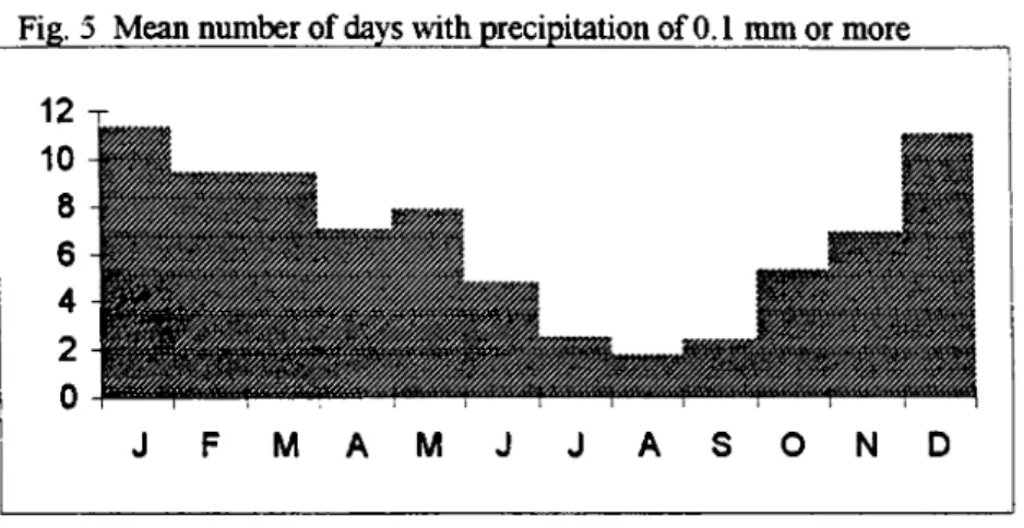
Fig. 5 Mean number of days with precipitation o f 0.1 mm or more
J F M A M J J A S O N D
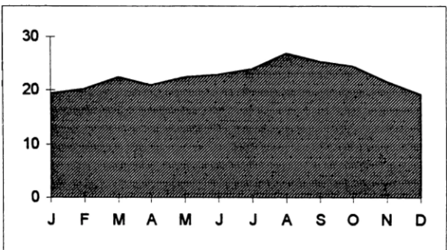
The mean annual precipitation (fig. 4) for the years between 1953 - 1990 has been given as 504 mm. Starting with the month o f December through M arch the monthly precipitation remains over 45-50 mm. With November and December this amount reaches 92 mm and January displays the w ettest month with the highest precipitation
17
rate o f 101.7 mm. A fall from 50 mm to 30 mm is observed between the months o f March and April. Precipitation rates for the summer remain under 10 mm. with
August presenting the lowest rate at 6.9 mm. From September to October the amount o f precipitation steps up from 8.0 mm. to 32 mm. The w ettest period o f the year seems to begin in October, lasting till May, with a quite gradual increasing and decreasing cycle throughout the year. The mean number o f days with a precipitation rate o f 0.1 mm. or more does not exceed 11 per month, which represents the amounts for December and January (fig. 5).
The annual average o f relative humidity is 56 %. Between the months o f October to May it remains over 50 %, with the highest rate reaching to 72 % in December and 71 % in January. The high humidity rates result in mist formation o f 3-4 days in these months. In the summer months o f June, July and August humidity remains around 40- 45 %, contrasting with the high humidity rates o f the coastal regions, which make the highlands a preferable location for the inhabitants o f the coastline zone during the summer months.
The mean annual rate o f evaporation (fig. 6), which is 1401.3 mm, is in great excess over the mean annual rate o f precipitation (=504 mm.). The plain is water deficient between the months o f May and November (fig. 6), and has its peak o f deficiency with the months o f June, July and August. Substantial irrigation o f the plain depending on its groundwater resources, becomes critically important during this
period. A surplus o f w ater occurs between the months o f November and March, which plays a dominant role in the plant growth during this period. The winter planting o f cereals in E lm alı takes place at the beginning and in the middle o f October till the end o f November, and the harvesting starts at earliest with the beginning o f June and continues till the end o f the month. Summer planting o f cereals, though practiced by few villages, starts in mid April, and continues till the end o f May. Harvesting takes place in late August.'“
The strongest winds predominantly seem to be the N orth wind, especially in the months o f March, April, May, September and December, and the north-northeast wind in January. The rain-bringing winds from the southwest and west appear to be strongest in February, October and November. The highest frequency o f winds are the south wind, followed by the west-northwest wind and the west-southwest wind.
The continental character o f the upland basin, with its cold winter months and high diurnal temperature differences, has neccessitated substantial dwellings for the
inhabitants o f the E lm alı Plain, especially if they aim to survive the winter months on the plain. The traditional Anatolian highland architecture, o f stone foundation with mudbrick superstructure and timber framework, is also characteristic for the E lm alı Plain. Although the m odem brick-cement architecture has taken over in the main tow n o f E lm alı (Plate 3a), the traditional timber framed mudbrick architecture (Plate
3b) still prevails in the older part o f the E lm alı tow n and is still the dominating form o f architecture for the villages in the plain,^' its thick walls providing for summer coolness and for warmth in the winter.
Information from K6v Envanter Etüdü Antalya 1981 (Village Inventory Summaries) : Tables 15.1 and 15.2.
According to the Kdv Envanter Etudlerine GOre Antalva tF.lm ali B u c a d i, 1964; Table 48; building material used in the villages o f E lm alı constitutes 89% o f mudbrick, 10% o f stone,; 68% o f the houses have pitched roo& and 31% have flat roofr. For heating purposes mainly wood and animal dung is used. According to the 1981 statistics o f the same publication; Table 3 : 3 ; presented in numbers, 3877 houses built o f mudbrick, 933 o f stone, and 388 o f brick, and in percentages as 76% , 17% and 7% respectively, showing the recent increase in the usage o f bride in the region o f E lm alı.
19
Excavations in K arataş - Semayük have proved that mudbrick architecture has been the dominant form o f architecture since prehistoric periods for the upland plains. From the archaeological point o f view this becomes an important factor, which enables the recovering o f the remains o f substantial buildings from various periods, their mudbrick architecture having resulted in the accumulation debris o f the mounds o f the upper plains. A large number o f mounds exists in these upland plains (Plate 13), but there are none in the coastal plains. The lack o f mounded sites from the coastal regions has been attributed to the usage o f more ephemeral building materials, such as wood, that would be more suitable for its mild climate. The existence o f multi-period mounded sites in the upland plains is very important for an understanding o f the earlier history o f the region.
1.3 VEGETATION
Modern vegetation:
The contemporary vegetation o f the region has been described by Zeist''^ as being within the Oro-Mediterranean Vegetation Belt (Plate 4), and surrounded by Alpine Vegetation, which exists over 2000 meters. Between 800 and 1200 meters, deciduous forests with coniferous forests occur. Up to 1000 meters coniferous forests are made up o f
Pinus brutia
(Calabrian Pine - K ız ılç a m ), andFirms nigra
(Black Pine - Karaçam). In warmer climatic zonesFirms brutia
may occur above 1000 meters and1200 meters. The dominant tree in the deciduous forests is
Quercus cerris
(Turkish Oak - M eşe).Quercus calliprinos
is frequently found in the shrub layers o fPinus
brutia
and also forms an undergrowth forFirms nigra
forests.Zeist et. al., 1979: 65-67. The quaternary vegetation o f Southwestern Anatolia including the upper highlands o f Northern Lycia has been stucUed by Zeist, Woldring and Stapert in 1973. The
investigations have included both surface sampling and sediment coring from lake sites in order to reconstruct a pollen diagram o f the late Quaternary including the last glacial and the postglacial periods. Together with a general description of the contemporary vegetation has been given. The following information has been cited from there.
Between the upper forest zones o f 1200-2000 meters, mainly coniferous forests are found; the forest vegetation consists o f
Pirns nigra
(upto 1800 meter), theCedrus
libcmi
( Lebanon cedar - Sedir),Abies cilicia
(Cilician fir - K ö k n ar) andJuniperus
excelsa
(Grecian Juniper - Boylu A rd ıç). ExtensiveCedrus
andAbies cilicia
forests, together with beautifulJuniperus excelsa
andCedrus libani
forests, exist southeast o f Avian Gölü, to the south o f E lm alı (Plates 5, 6). The shrub layers in these forests includesQuercus calliprinos
(Oak - M eşe),Juniperus oxycedrus
(Prickly juniperus - Katran A r d ıc ı) ,Lanicera
(H anım eli),Berberis
(Karamuk),Ptacia
ierebinthus/Palestina
(Terebinth - Menengiç). As a degeneration stage o fCedrus
-Juniperus
forests, aJuniperus excelsa - Quercus calliprinos
shrub vegetation is found in the same area. TheCedrus - Juniperus
forests near Avian Gölü occurs at as low as1050 meter. Dense forests o f
Cedrus Libani
have been an important resource for the subsistence o f the inhabitants o f the plain in the past, as today, and were used in antiquity especially in ship construction, house architecture, furniture, and for heating purposes. Reference toCedrus libani
occurs in ancient sources (eg.Pliny,XII. 132, XIU 52, XTV 137, Theophr. Hist. PI. III. 12.3). Travellers’ accounts o f the mid 19th century also mention the extensive use o f cedarwood in Elm alı for heating purposes, when a scent o f cedar surrounded the whole town, especially in the
evenings.'*^ In Reisen I, Bendorf and Niemann give reference to a large caravan o f 100 donkeys and camels loaded with cedar wood, east o f the Xanthos valley, heading towards the Kasaba Plain (which is located just to the south o f the E lm alı Plain). The wood apparently would have been shipped to Alexandria in Egypt. The same account reports the monopolising o f wood-handling in the hands o f the Lewissi o f Makri, the modem town o f Fethiye.
Fellows, 1852: 382.
21
At present there is a large quarter o f carpentry shops in the industrial center o f E lm alı, engaged in processing cedar wood which continues to be a source o f important income for the inhabitants o f the town, although its use is now limited to furniture making and luxury items. Its growth and cutting is strictly controlled by the Forestry Department. Also, an Institution for the Research and Improvement o f the Growth o f the Cedar in the region, under the Forestry Department, exists in Elm alı. There are various publications on the
Cedrus Li bani
o f the Taurus mountains, one o f the most recent o f which gives detailed accounts o f the improvement programmes undertaken forCedrus Libani
in the region o f Avian Gölü.''^Ancient Vegetation:
The Quaternary vegetation o f the immediate region was studied by Zeist in 1973, based on a number o f sediment corings o f lake sites, including the lakes o f K aram ik, Beyşehir, Hoyran, K ö y c eğ iz and S ö ğ ü t . An additional study done by Bottema and Woldring has included core saplings from the Karagöl and Avian Gölü, in 1977.^’ As a result o f the core sample from Karagöl/Elm alı three zones have been defined.“** Zone one has been dated to a period between 4000-3000 BP and points to the domination o f cedar and pine forests in the region, with
juniperus excelsa
covering slopes o f the mountain at 1000 m. and above. Towards the end o f the period (ca. 3000 BP) wallnut trees occure in small percentage. Both Karagöl and Avian Gölü points to a hiatus o f pollen between zone one and two. Farming is one o f the most critical types o f human interference with natural plant cover. Evidence for man’s interference with vegetation starts with zones tw o and three (no dates have been given, but they are in the range o f the second and first millenia b.c), with forests beingBoydak, 1996.
^ Zeist, et. al., 1979: 55-142.The Söğüt Lake is located 60-80 km. as the crow flies to the north o f the E lm alı Plain, and displays the nearest locality with a similar geographical and climatic set-up to that o f the E lm alı Plain.
Bottema and Woldring, 1986: 140-43.
““ Ibid, 141. The pollen samples could not been dated by C14, because o f the non-existence o f organic m aterial. These zones have been dated by means o f corrolations with pollen diagrams horn Söğüt, P ın a m a şı and Beyşehir, and the sediment sample has been defined as circa 4000 years old
cleared over large areas. Palynological evidence for grain growing and cultivation o f fruit trees with
juglani
(walnut),castanea,
o/ea (olive tree),vitis
(vine), andcitrus
exists in zones tw o and three (see Chart 1).'*’Two zones have been defined for the Avian Lake, which range over a period o f 8000 BP. During zone one dense cedar and pine forests seem to cover the slopes o f the mountains to the southern o f the plain, with pine overtaking tow ards the end o f the period. Occurance o f Cereaha-type o f pollen
(Plantago lanceolata, Rumex
acetosa)
indicated to agricultural activity in the region possibly along the northern part o f the lake.*® With zone two, human involvement becomes clear. Pollen evidence o fPlantago, Juglans, Vitis
andOlea
exists, but low in percentage. There seems to be a striking difference in the percentage o f walnut trees between E lm alı and Avian Lake, where in the the K aragöl/Ehnalı the percentage o f walnut trees reach to 20%, pointing to extensive orchards in the area. Overgrazing o f land and herding activities around Avian Lake is appearant in zone two with the increasingPoterium
andPlantago lanceolata
pollen (see Chart 1).**The pollen diagrams from the Söğüt Lake (see Chart 1) suggest that during 20 000 - 10 000 BP, a drier climate with a fiall glacial and late glacial steppe
vegetation, consisting o f
Artemisia
(yavşan, pelin otu, otçul bitkiler). With moister phases, more or less open forests o f pine-cedar and deciduous oak prevailed. Late in 8 500 BP, increasing moisture was the characteristic o f Forest Vegetation, which started to expand in the mountains o f Southwestern Turkey. During 6 000 - 5 500 BP, forests completely took over the Oro-Mediterranean Vegetation Belt (at ca. 800- 2000 meters). Human interference with the environment is also evident around Söğüt Lake, from as early as the second and first millenium b.c.“'•’ Ibid, 141. “ Ibid, 142.
Ibid, 142-43. 52
CHART 1
Tentative correlation of the vegetation history as taken from the pollen diagrams for the region
B.P. SÖĞÜT LAKE' ELM ALI^ A V IA N LAKE’
1000- pine forests forests (cedar and pine)
forest regeneration forest clearing NO POLLEN forests 2000-3000 forest regeneration
forest clearing NO POLLEN
4000-predominantly pine forests forests
(pine, cedar, juniper)
predominantly pine forests forests (pine, cedar)
5000- 6000- 7000-
8000-forests
(oak, juniper, pine) transition firom steppe and forest-steppe
to forest
9000-10 000- steppe with scattered tree stands
11000-
12000 -13 14 15
000-mosaic of steppe and forest stands (mainly oak and pine)
20000- ■
predominantly steppe with tree stands
25 000-·
less forest than the earlier period mosaic of steppe and oak-forest stands
steppe with forest stands (conifers and deciduous trees)
' Z eistet al., 1979:138.
^ Bottema and Woldring, 1986:145, fig. 16.
^Ibid-Presently, E lm alı Plain proves to be one o f the most fertile upland basins o f the region. Its productivity has been increased by means o f drainage and irrigation
systems since the 1960s. Dry farming was practiced in the region before that, when its surface and subsurface waters were sufficient for this type o f agriculture. Cereals and fhiits seem to be the dominating crops o f the plain. Travellers’ accounts since the 19th century continuously point to the mild climate and the fertile lands o f the plain, calling it the com capital o f the whole o f Lycia. These accounts give us a lot o f information on how the plain and its environs looked at in the turn o f the century. These especially the accounts o f Fellows” , Spratt and Forbes*'*, Hoskyn” , Davis*® and Schönbom*^ prove to be valuable sources.
The distribution o f the cultivated land in the present day E lm alı region is as follows; forests 29%, grazing land 15%, dry farming fields 32%, irrigated fields 5%, orchards and vineyard 5%.* ** Todays’s main crops and their aimual yields have been grouped in see Chart 2. Cereals, vineyards, apple orchards and the industrial crops o f sugar beet and aniseed remain the main products o f the plain. Another important product o f the region is honey, which was used to be collected from the behives on built stone pillars, which the traditional beehives are still present today in the Geçmen- Söğle region, southeast o f E lm alı (Plate 14).
** Fellows, 1852; 381. The passages have been cited in Appendix B. 1. *'* Spratt and Forbes, 1847: 280, 286 ( Appendix B.2a-c).
** Hoskyn, 1842: 153-156 (Appendix B.3a-b). *® Davis, 1874: 237 ( ^ ^ n d ix B.4).
*^ Ritter, 1859: 814 (A f^ n d ix B.5). *® K6v Envanter Etüdü Antalya 1981 59.
CHART 2
Crop yield for the E lm alı n a in as taken from the statistic accounts of D.LE., Ankara
Field Crops 1993 (gross yield in tons)
1994 1995 19% Wheat 46 397 46 420 46 937 46 826 Barley 33 451 35 433 35 665 32 740 Oats 1013 1212 1227 869 Chickpea 4 988 4 783 7 000 6 300 Green pea 1752 1400 1 575 2 000 Onion 1 854 4 067 6 984 9 167 Patatoes 5 485 7 638 6 348 8 098 Tomatoes 29 500 31 500 33 7503 7 500 Water melon 14 152 15 623 20 000 18 000
Fodder (animal feeding)
Luceme(yonca) 8 750 1700 1900 2 0 0 0 (Korunga) 2 250 450 600 0 (Fig) 5 895 1 115 1400 0 Industrial crops 1992 1993 1994 1995 1996 Sugar beet - 63 381 77 345 65 001 74 225 Aniseed - 1479 2 237 1600 1500 O rchards/fniit trees (number of trees) Apple 1400 000 1 137000 1 137 000 1 157 000 1205 000
Vine 2954 ton (315 ha.) 2945(325 ha.) 4 500(325 ha.) 5 425(325 ha.) 5425(325 ha.)
Pears 198 000 198 000 1% 000 196 000 161000 Ouince 15 000 16 000 16 000 17 000 19 000 Apricot 5 750 6 500 6 600 6 600 6 9 0 0 Plum 8 140 9 000 9 300 9 300 11000 Oleaster 600 700 700 700 700 Peach 19 000 19 000 19 000 19 000 20 200 Morello cherry 2 0 0 0 2 100 2 100 2 100 2 200 Sweet cherry 30 0 0 3 250 3 250 3 250 3 250 Walnut 39 0 0 4 200 4 300 39 0 0 39 0 0 Almond 6 000 6 000 6 300 6 000 6 000 Mulberry 1300 1000 1300 1300 1300 Comellian cherry 1000 1050 1050 1000 1000