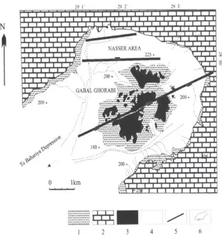
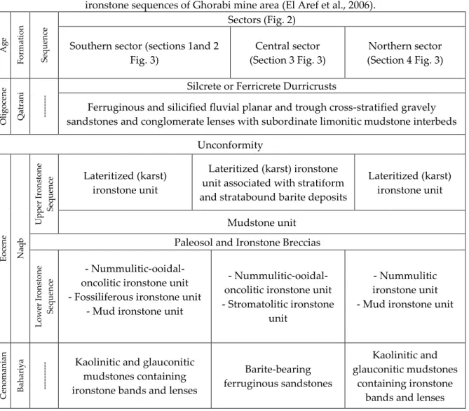
Stratigraphic settings and mineralogy study on the Eocene ironstones of Gabal Ghorabi Mine area, El Bahariya Depression, Westwen Desert Egypt
Tam metin
Şekil
Benzer Belgeler
The objective of our study was to determine the prevalence, awareness, treatment, and control rates in a population (aged 25 or older) from Derince dis- trict of Kocaeli county,
Vospominaniya kak istochnik izucheniya istorii Omskoi oblasti (k voprosu ob istorii ischeznuvshikh dereven Kolosovskogo raiona Omskoi oblasti) [Memoirs as the Tool
Yılın, yılların, bütün bir yaşamın Atatürk devrimcisi Nadir Nadi plaket ve beratı alırken çok duygulandı. Bütün ömrünü verdiği düşünce savaşımında çabasının
The primary source of data was the complete work of Swami Vivekananda and interpretations and synthesis developed by recent scholars in various fields.. Findings: The major
Appendix 4.1 Table of the annual surface runoff (mcm) of the 10 rivers originating from Troodos Mountains.. Appendix 4.2 Table of the predicted annual surface runoff (mcm)
The Tek-clear AIOL (Tekia, Irvine, California, US) is also a single-piece (optic), hydrophilic acrylic IOL with symmetric optic and square edge design that has been approved for
Esas olarak, cevher parajenezinin benzer olduğu bu evrelerden birincisi kuvars diyorit, tonalit ve granodi- yoritlerden oluşan granitoidin yerleşmesi ile birlikte, anakayaç içinde
Ortak kökleri olan kültürlerin, paylaştıkları değerler olabilir veya kültür alışverişi yoluyla değerler toplumlar arasında yayılmış olabilir, ama
