Journal of Environmental Science and Management 23-1: 71-82 (June 2020) ISSN 0119-1144
Zeynep Rabiye Ardahanlioğlu1 Serdar Selim2*
Nihat Karakuş3 İsmail Çinar1
1 Muğla Sıtkı Koçman University, Department of Landscape and Ornamental Plants, Muğla,Turkey 2 Akdeniz University, Faculty of
Science, Department of Remote Sensing, Antalya, Turkey 3 Akdeniz University, Institute of
Science, Department of Remote Sensing and Geographic Information Systems, Antalya, Turkey
*corresponding author: [email protected] ABSTRACT
This study determined the settlement areas that were suitable for the natural environment in the Seydikemer District in Turkey. Within this context, databases related to the natural environment of the region and existing land uses were created using Unmanned Aerial Vehicle images that were digitized and analysed using geographic information systems. Land cover was classified using Random Forest and Maximum Likelihood Classification methods for remote sensing. The natural environmental properties of the study area were determined based on the resulting classification, and the criteria for the suitability of the settlement areas were defined by the Multi-Criteria Decision Analysis and Analytic Hierarchy Process. Accordingly, eight main criteria and their classes of suitability were analysed and evaluated. Assessment of the natural suitable structure of the area was conducted using weighted overlay analysis. Sixteen percent of the survey area was suitable, while 69.01% was moderately suitable and 14.97% was not suitable for use as a settlement area. Considering that this region is in the process of rapid urbanization, The findings of the study are expected to make a significant contribution to the future settlement and land-use plans of the city.
Key words: land-use planning, Multi-Criteria Decision Analysis (MCDA), suitable
settlement, Unmanned Aerial Vehicle (UAV), Geographic Information System (GIS)
INTRODUCTION
The rapid growth of cities has led to the emergence of concepts such as planned growth, physical planning and urban planning (Kozlowski and Hughes 1972). The development and growth of urban settlements depend on many physical and cultural criteria (Sýkora 2017). These criteria are composed of land use, transportation, settlement, industrial and agricultural production, consumption, social activities and cultural structure, which have significant impacts on natural resources during the planning phase (Hersberger et al. 2018). The natural environment is adversely affected by the scattered development of today’s cities and the expansion of large urban areas into complex structures (Amato et al. 2016). To reduce the negative effects of urban sprawl on the natural environment, ecological planning approaches should be adopted and included in the planning stages (Haaland and van den Bosch 2015, Bai et al. 2018). Additionally, the protection of natural resources and prioritization of sustainability should be achieved (Rad
et al. 2018). The main goal of the sustainable ecological
planning approach is to protect nature and increase urban quality (social, cultural and spatial quality; Selim et al.
2017, Lantitsou 2017, Li et al. 2017).
JESAM
GIS-Based Approach to Determine Suitable
Settlement Areas Compatible with the Natural
Environment
Although ecological approaches are important for urban planning, in recent years in Turkey, it has not been fully implemented during the application stage. In the preparation of urban plans at the regional and local scale, the ecological structure should be carefully considered (Alphan and Güvensoy 2016, Berberoğlu et al. 2016). In order to harmonize economic development with the natural environment, it is necessary to define a planning concept that integrates environmental components and to incorporate this planning model in development plans, environmental policies and ecological planning processes (Lennon 2015, Geneletti et al. 2017, Hamma
2018). Ensuring the sustainable use of natural resources
depends on the correct implementation of land-use plans that are compatible with the natural structure of the environment (Bryan et al. 2016, Rad et al. 2018). Turkey is experiencing a process of rapid urban transformation; and during this process, the conservation of natural resources and preparation of urban master plans that are compatible with the land’s natural structure are critical (Aksoy and Selim 2020).
value; and for that reason, it is the most important tourism and agricultural destination in Turkey. Seydikemer is one of the most important agricultural regions in the Mugla Province and was selected for this study to determine settlement areas that could align with the principles of sustainability. As there is an increasing need for settlements in this region due to rapid population rise, the natural environment needs to be safeguarded and the efficient use of natural resources should be sustained. As a result of the rapid population growth trend in the region, the existing physical plans are inadequate, and local governments are unable to meet demand while finding an ecological balance. Consequently, due to increased concreting, the natural environmental structure is deteriorating and urban forests, green areas and fertile soils that provide many ecosystem services (Hosseini et
al. 2019) are declining. Natural ecological systems suffer
and lose their resilience. Therefore, it is necessary to develop physical plans and future scenarios for a given region to meet expectations and goals for sustainability, construction and social structure (Ekpodessi and
Nakamuro 2018, Long and Qu 2018).
The necessity to use social, cultural, physical and ecological criteria together in land-use plans makes the use of Multiple-Criteria Decision Analysis (MCDA) preferable in such studies (Jeong 2018, Uhde et al.
2015, Sani et al. 2016, Selim et al. 2018, Ristić et al. 2018, Fernandes et al. 2018). The use of MCDA in
conjunction with Analytic Hierarchy Process (AHP) is preferred in land-use planning as a synthesis method that systematically examines the advantages and disadvantages of different alternatives and different criteria to obtain valuable results (Mosadeghi et al. 2015,
Yatsalo et al. 2016, Adem Esmail and Geneletti 2018).
The main objective of this study is to determine suitable settlement areas that are compatible with the natural environment of the Seydikemer District, which is not yet densely populated, by using MCDA and AHP. Within this context, the socio-cultural, physical and ecological criteria of the region were evaluated and a set of criteria were selected for analyses. The findings of the study provide insight for local and regional governments and decision-makers about the district. Moreover, this study can serve as an important guide for decision-makers from different disciplines as it presents a methodology that allows different criteria to be evaluated for sample areas, thus potentially having a large impact on the methodological set-ups of future land-use planning projects.
MATERIALS AND METHODS
The Seydikemer city centre and surrounding area located in southwest Anatolia was selected as the study area. The province is located in the Mediterranean Region, surrounded by small cities and the Eşen River. Geographically, the study area is located between 36º 17’ – 37º 02’ N and 29º 07’ – 29º 48’ E and has an area of 2,028.37 km² (Figure 1). The boundary of the study area is denoted as a circle with a radius of 5 km, which includes all the settlements and buildings in the city center.
Seydikemer District was chosen as the study area due to a rapid increase in the urbanization rate of the region to the direction from Mugla province to the district due to its topographic structure and its potential in terms of agricultural lands and natural resources.
In the present study, 1/25000-scale geological and topographical maps of the area with master plan and WorldView-3 with GeoEye Ortoready pansharpened satellite images at a resolution of 50 cm with 4 bands (RGB+NIR) were used. These maps were used for the classification of land cover. Additionally, Unmanned Aerial Vehicle (UAV) images were used to control and correct the actual master plan of the region. Infastructure, such as roads, buildings, etc., which were not included in the current master plans, were identified by land surveys. Their high-resolution images were taken with UAV and integrated into satellite images, resulting in land-cover classification made with high accuracy and control.
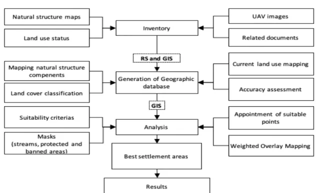
The study methods consisted of three stages (Figure
2). In the first stage, the baseline information (such as
zoning plans, residential area limits, population, soil maps, green areas, etc.) of the study area were prepared and/or collected using literature reviews, field studies and materials obtained from public institutions and organizations. A large inventory covering the region was executed and a database was created.
In the second stage, the current state maps needed for the determination of areas suitable for settlement were digitized using Geographic Information Systems (GIS). In this regard, land-use capability classes and maps of drainage areas were digitized using the 1/100000 scale Muğla province land assessment map. Geological formations and fault lines maps, slope, elevation maps and hydrology maps were created using topographic maps. Land-use status maps with a controlled classification of satellite images and Principal Component Analysis (PCA) with high accuracy were obtained. In the controlled classification process, 100 training and 300 test pixels
were created for each land-use class and graded with Random Forest (RF) and Maximum Likelihood Classification (MLC) methods. At the end of the classification, a confusion matrix algorithm (a technique used to measure the performance of a classification algorithm) was used to calculate the classification accuracy for RF and MLC (Table 1). The calculations indicated that the classification using the RF method had the highest accuracy value, and thus the classified image obtained by this classification technique was used for further analysis.
In the last stage, the obtained data were evaluated with MCDA. MCDA is an integrative approach that evaluates physical, ecological, economic and social data (Martinez and Alonso 1995, Lier 1998, Matthews et al.
1999, Weerakoon 2002, Bagheri et al. 2012, Mosadeghi et al. 2015, Selim et al. 2018). First, the main criteria
and sub-criteria were determined for assessing eligibility for settlement (McHarg 1969, Matthews et al. 1999,
Ardahanlioglu 2014, Mosadeghi et al. 2015). To increase
sensitivity of the analyses, the conformity values of the
Figure 1. Geographical location of the study area.
Figure 2. Method flowchart in determining suitable settlement areas.
Natural structure n-.aps
Land use status
Mapping natural structure
compenents
Land cover dassification
Suitability c:riterias
Ma.sks
(streams,. protected and banned areas)
-LEGEND•
F!jMRi1.•t)r C Road Inventory Generation of Geographic database AnalysisBest settlement areas
Results ... , BB
·--
'
'
;.\
'
i
~ I !-, I ii
"
A
-;.
•
.
~
:.
':::::
'
....
-~
2""
UAV images Related documentsCurrent land use mapping
Accuracy assessment
Appointment of suitable points
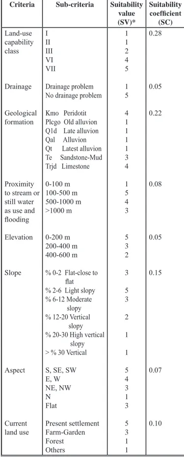
sub-criteria were formed according to a five-point rating system. The scores of the sub-criteria that did not show similarity with the sub-criteria of previous studies were determined based on expert opinion. More specifically, literature studies were taken into consideration with the opinion of seven experts (one architect, landscape architect, environmental engineer, land expert, hydrologist, geologist and geographer) who were knowledgable about the region. The weights of the criteria were then obtained using MCDA. In determining the points in the sub-criteria, suitability as a settlement area was considered. Accordingly, if the sub-criteria was considered very suitable for use as a settlement area, it was given five points, four points if it was deemed appropriate for use as a settlement area, three points if moderately appropriate, two points if it was unsuitable and one point if it was never suitable for use as a settlement area. Compliance coefficients were also determined by using the criteria as a settlement area (Table 2).
Subsequently, suitability status maps were created for settlement areas. First, the maps created in vector format were converted to raster format with a cell size of 1×1 m to increase the sensitivity of the analyses. Next, the determined conformity values of the sub-criteria in each criterion were assigned to the maps converted to raster format. For the determination of settlements that are compatible with the natural environment, the conformity maps were subjected to weighted overlay analysis taking into account the conformity criteria. As a result of the analysis, the most suitable settlement areas were mapped and classified according to availability.
RESULTS AND DISCUSSION
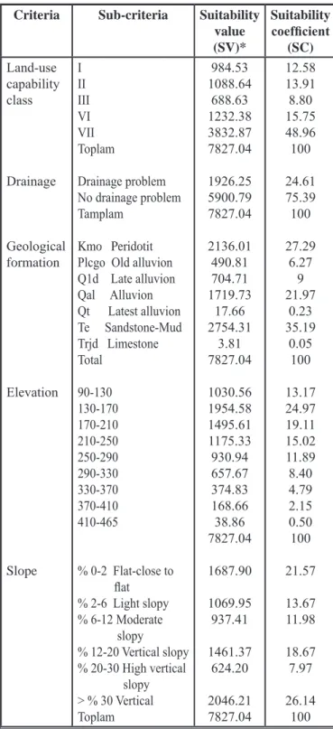
The findings of the research consisted of the sub-criteria values obtained as a result of the MCDA analysis and the percentage of the criteria taken as a result of that analysis. The results of the analysis of the main criteria (land-use class, drainage, geological formation, hydrology, elevation, slope, maintenance and existing land uses) defined as natural environment components are given in (Table 3).
Table 1. Random Forest and Maximum Likelihood Classification. Near-Infrared Red-Green-Blue Principal Component Analysis
Mean Kappa Mean Kappa Mean Kappa
MLC
RF 78.4883.74 0.75790.8171 81.2278.44 0.78870.7575 72.0084.92 0.68500.8304
Table 2. Assessment criteria, sub-criteria and conformity values selected in the determination of settlement areas suitable for the natural environment.
Criteria Sub-criteria Suitability value (SV)* Suitability coefficient (SC) Land-use capability class Drainage Geological formation Proximity to stream or still water as use and flooding Elevation Slope Aspect Current land use I II III VI VII Drainage problem No drainage problem Kmo Peridotit Plcgo Old alluvion Q1d Late alluvion Qal Alluvion Qt Latest alluvion Te Sandstone-Mud Trjd Limestone 0-100 m 100-500 m 500-1000 m >1000 m 0-200 m 200-400 m 400-600 m % 0-2 Flat-close to flat % 2-6 Light slopy % 6-12 Moderate slopy % 12-20 Vertical slopy % 20-30 High vertical slopy > % 30 Vertical S, SE, SW E, W NE, NW N Flat Present settlement Farm-Garden Forest Others 1 1 2 4 5 1 5 4 1 1 1 1 3 4 1 5 4 3 5 3 2 3 5 3 2 1 1 5 4 3 1 3 5 3 1 1 0.28 0.05 0.22 0.08 0.05 0.15 0.07 0.10
land area was suitable as a settlement area in terms of land-use class, while 8.80% was unsuitable and 26.49% was mostly unsuitable, with 35.29% of the total area not suitable for settlement use (Figure 3).
Approximately 24.61% of the research area had drainage problems, and certain parts of these lands were located within the zoning boundaries. There was no drainage problem in 75.39% of the total area. Examination of the suitability status map and numerical data revealed that 27.34% of the research area was suitable as a settlement area in terms of geological structure, 35.19% of the area was moderately suitable and 37.47% of the area was not suitable as a settlement area. Geologically, 27.29% of the research area was peridotite (Kmo), 6.27% was old alluvion (Plcgo), 9.00% was late alluvion (Q1d), 21.97% was alluvion (Qal), 35.19% was sandstone-mudstone (Te) and 0.05% consisted of limestone (Trjd) formations.
The majority of the research area consisted of high slope groups. There were low slopes around the D400 highway in the north and south of the city and west of the Eşen River within the boundaries of the zoning plan.
Table 3. Numerical data of the natural environment components of the city of Seydikemer and its vicinity.
Criteria Sub-criteria Suitability value (SV)* Suitability coefficient (SC) Land-use capability class Drainage Geological formation Elevation Slope I II III VI VII Toplam Drainage problem No drainage problem Tamplam Kmo Peridotit Plcgo Old alluvion Q1d Late alluvion Qal Alluvion Qt Latest alluvion Te Sandstone-Mud Trjd Limestone Total 90-130 130-170 170-210 210-250 250-290 290-330 330-370 370-410 410-465 % 0-2 Flat-close to flat % 2-6 Light slopy % 6-12 Moderate slopy % 12-20 Vertical slopy % 20-30 High vertical slopy > % 30 Vertical Toplam 984.53 1088.64 688.63 1232.38 3832.87 7827.04 1926.25 5900.79 7827.04 2136.01 490.81 704.71 1719.73 17.66 2754.31 3.81 7827.04 1030.56 1954.58 1495.61 1175.33 930.94 657.67 374.83 168.66 38.86 7827.04 1687.90 1069.95 937.41 1461.37 624.20 2046.21 7827.04 12.58 13.91 8.80 15.75 48.96 100 24.61 75.39 100 27.29 6.27 9 21.97 0.23 35.19 0.05 100 13.17 24.97 19.11 15.02 11.89 8.40 4.79 2.15 0.50 100 21.57 13.67 11.98 18.67 7.97 26.14 100
Table 3. Numerical data of the natural environment components of the city of Seydikemer and its vicinity. (cont.)
Criteria Sub-criteria Suitability value (SV)* Suitability coefficient (SC) Aspect Proximity Current land use Flat surfaces N NE E SE S SE W SW Total 0-100 m 100-500 m 500-1000 m >1000 m Toplam Present settlement Agricultural land Forest Water Other Total 4330.17 137.40 503.79 373.09 546.00 413.82 581.22 417.20 524.35 7827.04 654.13 1372.06 1494.27 4306.58 7827.04 293.67 1256.75 4722.34 47.17 1507.11 7827.04 55.32 1.76 6.44 4.77 6.98 5.29 7.43 5.33 6.70 100 8.36 17.53 19.09 55.02 100 3.75 16.06 60.33 0.60 19.26 100
Within the boundaries of the research area, I, II, III, VI and VII class soils constituted 12.58% of the research area, and approximately half of the classes were located in the city center within the boundaries of the zoning plan. Class II soil covered 13.91% of the research area, class III soil covered 8.80% of the total area, class VI soil covered 15.75% and class VII soil constituted 48.97% of the area. These results indicate that 64.71% of the total
In terms of slope groups, 13.67% of the land was very suitable as a settlement area, 33.55% of the total land was moderately suitable as a settlement area and 52.78% of the area was unsuitable. In the research area, the city centre within the boundaries of the zoning plan was located 90-170 m in elevation. Elevation increased when moving east, north-west and south-west from the city center.
According to the elevation map results, 52.80% of the research area was very suitable, 46.41% was moderate suitable and 0.79% was not suitable as a
settlement area. Most of the city center within the zoning plan consisted of flat areas in southern directions of the district. According to the results of the aspect map, 19.70% of the survey area was very suitable and 29.80% of the total land was suitable to be a settlement area, while 68.44% was moderately suitable for being a settlement area and 1.76% of the land was not suitable for the settlement areas.
Water, which is a critical resource in social and ecological systems (Malenab et al. 2016), is an important factor affecting settlement in the region. In terms of
Figure 3. Land-use maps for settlement: (1) Land-use capability class; (2) Drainage suitability map; (3) Geological formation suitability map; (4) Elevation suitability map; (5) Slope suitability map; and (6) Aspect suitability).
7
,
.,,,
.
,
.
,,,
.
-
·
-
·-
·
·
-
·
,,/ / ; iI
i i \ - D350 and D400 Highway- -E~en and Terzi River
Stream Bed LJ Neighborhood Border = . . . : Development Plan
CJ Study Border Settlement Suitability
- Extremely Unsuitable Unsuitable D Moderately Suitable
Suitable
- Most Suitable
N
A
0 0.5 1 2important streams are the Eşen River and Terzi Stream. The Karanlık Stream and Toplar Stream located in the northeast, Babaveli in the west and İnce Stream in the southwest of the research area run into the Eşen River. In terms of proximity to streams and still water sources with flood hazard, 17.53% of the survey area was very suitable and 36.62% of the total area was suitable to be a settlement area in terms of its proximity to streams and still water resources, while 55.02% was moderately suit-able for being a settlement area and 8.36% of the land was not suitable for settlement areas.
The study area consisted of the following: 6.50% ur-ban areas; 7.90% rural settlements; 54.43% forest areas; 25.38% agricultural areas and integrated plant areas for agriculture; 0.89% trade area; 0.24% small industrial area; 0.47% school area; 0.13% fair area; 0.39% landslide; and 3.68% rocky stony area. According to the current land use, 3.75% of the research area was very suitable for being a settlement area in terms of the existing land use, while 16.06% was moderately suitable for being a settlement area and 80.19% of the land was unsuitable for being a settlement area in terms of existing land use (Figure 4).
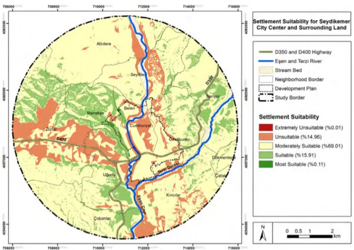
Based on the map of suitability status of the Seydikemer city center and its close surroundings (5
km buffer zone), the Zorlar, Seydiler and Cumhuriyet neighbourhoods and Eşen Stream were not suitable as settlement areas in terms of the natural environment. The districts of the Gerişburnu, Belen, Kıncılar and Atlıdere neighbourhoods were moderately suitable for settlement, while the regions located in the vicinity of the Menekşe, Sarıyer and Uğurlu neighbourhoods were suitable for settlement. However, some parts of Atlıdere, Seydiler, Sarıyer, Gerişburnu, Kıncılar, Dökmentepe and Çatak neighbourhoods were not geologically suitable due to landslides. Furthermore, the places within the zoning borders were moderately suitable and partly unsuitable for settlement. Class I and II agricultural lands were not ecologically appropriate as settlement areas. Therefore, the construction for the boundaries of the Cumhuriyet neighbourhood where these agricultural lands are located should be limited. Additionally, this analysis showed that the development direction of the city is not suitable for the neighbourhoods of Seydiler and Zorlar around Eşen Stream. The direction of urban development towards the Menekşe, Uğurlu and Çobanlar neighbourhoods seems to be more appropriate (Figure 5 and 6).
Stream coasts are generally used as settlements and that the highway route and its surroundings show rapid urbanization (Chandra et al. 2018, Sahana et al. 2018,
Figure 4. Suitability map of settlement compatible with the natural environment.
706000 708000 710000 712000 714000 716000
I
\
,,
'
I
Settlement Suitability for Seydlkemer ~ City Center and Surrounding LandI
- D350 and D400 Highway
- E~en and Terzi River
1 Stream Bed
D
Neighborhood Border = ... : Development Plan .-•--. '--, _; Study Border Settlement Suitability - Extremely Unsuitable (%0.01) - Unsuitable (%14.96)D
Moderately Suitable (%69.01) Suitable (% 15.91)- Most Suitable (%0.11)
' . . . , • , • ~banla(
1 _ _ _
~_"'_~~_
·
_
"·
-~·-=--
;-
::..
...
..:..-=.
_
_ _
~
_ _
_,_.1
I
A
I
0-
0-=:::::i- - •
.5 2km
Zambon et al. 2019). The main reasons for this are a lack
of economic opportunities and infrastructure (Maithani
et al. 2019). However, stream coasts and low slope areas
are known to have soil structures that are mostly suitable for agriculture (Tromboni and Dodds 2017, Roy et al.
2018, Wild et al. 2019). It is important to use these areas
for agriculture within the scope of sustainable agriculture policies, especially in developing countries, and to include and protect them as agricultural land in master plans (Langat et al. 2019). This study found that the region, which has entered a rapid urbanization process, has generally developed along the stream coasts and the highway route. This current development puts pressure on fertile agricultural land. In developing countries such as Turkey, it is important to determine the direction and speed of urban sprawl and to develop recommendations to ensure environmental and economic sustainability in development plans.
This study presents an important methodological
guide that can be used at both national and international levels. Various classification algorithms have been used in many land-use planning studies that used remote sensing techniques (Huang et al. 2018, Zhang et al.
2019). Generally, only one classification method is
used and this classification result is expected to have a high accuracy (Islam et al. 2018, Zhang et al. 2018). In this study, two different classification techniques using different algorithms were tested and the one with higher accuracy was chosen. Land surveys were carried out and UAV images were included in the current classification to increase accuracy. Thus, sensitive and up-to-date data were obtained and decisions for suitable settlement areas were developed. MCDA, which evaluates the region according to different criteria, was also used in the study methodology. MCDA is known to have high accuracy and is preferred in the evaluation of multiple criteria and even their sub-criteria (Jeong 2018, Musakwa 2018). Several studies argue that expert opinions should be considered when determining the criteria and their weights (Kazemi
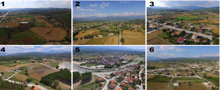
Figure 5. View of unsuitable lands for settlement obtained by UAV (1. Ugurlu and Zorlar neighborhoods; 2. Zorlar neighborhood; 3. Cumhuriyet neighborhood; 4. Belen neighborhood; 5. Cumhuriyet, Menekşe and Gerişburnu neighborhoods; 6. Gerişburnu neighborhood).
Figure 6. View of suitable lands for settlement obtained by UAV (1. and 2. Menekşe neighborhood; 3. Ugurlu neighborhood).
and Akinci 2018, Badia et al. 2019). Although many
MCDA studies do not include expert opinions (Samanta
et al. 2016), the views of experts who live in the region
and/or have knowledge about the region were included in the methodology, which allowed the criteria to be accurately weighted in terms of different disciplines..
CONCLUSIONS AND RECOMMENDATIONS
Human activities and unsustainable interventions have caused significant damage to the natural environment (Bruna et al. 2013, Janda et al. 2014, Cervenka et al.
2014). These changes in the natural environment can
significantly affect ecosystems (Foley et al. 2005,
Verburg et al. 2009). Considering that urbanization
activities are still very recent in Seydikemer, it is crucial that development plans be compatible with nature within the scope of landscape planning to prevent problems associated with the unsustainable use of the area in this region (Lier 1998, Rich and Yilmaz 2008, Yesil and
Yilmaz 2013). This study, which presented an important
example for this region, settlement areas compatible with the natural environment were determined. It was found that 16.02% of the survey area was suitable for use as a settlement area, 69.01% was moderately suitable for use as a settlement area and 14.97% was unsuitable for use as a settlement area. As a result of the analysis of the settlement areas compatible with the natural environment and the existing rural and urban settlements, 13.51% of the existing rural settlements were found to be suitable, 61.84% moderately suitable and 24.65% were unsuitable for settlement. Of the existing urban settlements, 7.03% were found to be suitable, 68.12% moderately suitable and 24.85% were unsuitable for settlement.
This study propose the following recommendations to help facilitate the sustainable development of the city and respond to future expectations. For the settlements that have been removed from the status of municipality and have been transformed into a neighborhood, agricultural activities should continue in a controlled way in the settlements located on fertile agricultural lands watered by the Eşen River. If the agricultural areas in the Seydikemer city center and its surrounding areas are allowed to be built, there will be loss of agricultural land due to improper land use on fertile land. The sustainability of agricultural activities in the region should be ensured now and in the future, considering that the rural fabric of the region is still intact and the livelihoods in the region are predominantly based on agriculture. Therefore, suitable areas for agricultural activities should be preserved and designated for agricultural use in zoning plans. Regarding the development of social and cultural
opportunities in the region, existing urban areas and the regions that are suitable for the development of recreational areas should be taken into consideration in the zoning plans, and the recreational areas that address the whole of the city and have equal distribution in the region should be incorporated in the plans.
The maps and study results created within the scope of ecological planning are a very important knowledge base that can be integrated into the planning processes of central and local governments. Therefore, taking these and similar scientific studies into account in all planning stages related to the region and acting jointly with related professional disciplines is crucial for the sustainable social, cultural, ecological and economic development of the region. This study supports the understanding of sustainable urbanization in the region, which has not yet completed urban development plans, and offers applicable suggestions to decision-makers by presenting a methodology that can be adapted to local and regional settings. It is expected that this study will play an important role in the future physical planning of Seydikemer and will be a reference especially in regions that has not yet completed urban development plans.
REFERENCES
Adem Esmail, B., and Geneletti, D. 2018. “Multi-criteria decision analysis for nature conservation: A review of 20 years of applications.” Methods in Ecology and Evolution 9(1):42-53.
Aksoy, E., Selim, S. 2020. “An automated approach for determination and prioritization of urban potential risk areas within the scope of superstructure.” Natural Hazards: Journal of the International Society for the Prevention and Mitigation of Natural Hazards, 1-15. https://doi.org/10.1007/s11069-020-04026-4
Alphan, H., and Güvensoy, L. 2016. “Detecting coastal urbanization and land use change in southern Turkey.” Journal of Environmental Engineering and Landscape Management 24(2):97-107.
Amato, F., Maimone, B., Martellozzo, F., Nolè, G., and Murgante, B. 2016. “The effects of urban policies on the development of urban areas.” Sustainability 8(4):297. Ardahanlıoğlu, Z.R. 2014. “The Evaluation of Changes in the
Usage of Area Within Ecological Planning in Fethiye-Göcek Special Protection Area.” Atatürk University Graduate School of Natural and Applied Sciences Department of Landscape Architecture, Unpublished PhD Thesis, Erzurum/Turkey.
80
Bagheri, M., Sulaiman, WNA, and Vaghefi, N. 2012. “Land use suitability analysis using multi criteria decision analysis method for coastal management and planning: a case study of Malaysia.” Journal of Environmental Science and Technology 5(5):364-372.
Bai, Y., Wong, C. P., Jiang, B., Hughes, A. C., Wang, M., and Wang, Q. 2018. “Developing China’s Ecological Redline Policy using ecosystem services assessments for land use planning.” Nature Communications 9(1):3034.
Berberoğlu, S., Akın, A., and Clarke, K. C. 2016. “Cellular automata modeling approaches to forecast urban growth for adana, Turkey: A comparative approach.” Landscape and Urban Planning 153:11-27.
Bruna J., Wild, M., Svoboda M., Heurich, M., and Mullerova, J. 2013. “Impacts and Underlying Factors of Landscape-Scale, Historical Disturbance of Mountain Forest Identified Using Archival Documents.” Forest Ecology and Management 305:294-305. https://doi.org/10.1016/j. foreco.2013.06.017.
Bryan, B. A., Nolan, M., McKellar, L., Connor, J. D., Newth, D., Harwood, T., ... and Grundy, M. 2016. “Land-use and sustainability under intersecting global change and domestic policy scenarios: Trajectories for Australia to 2050.” GlobalEenvironmental Change 38:130-152. Cervenka, J., Bace, R., and Svoboda, M. 2014.
“Stand-Replacing Disturbance Does Not Directly Alter the Succession of Norway Spruce Regeneration on Dead Wood.” Journal of Forest Science 60 (10):417-424. https://doi.org/10.17221/43/2014-JFS.
Chandra, S., Sharma, D., Dubey, S. K. 2018. “Linkage of urban expansion and land surface temperature using geospatial techniques for Jaipur City, India.” Arabian Journal of Geosciences 11(2), 31.
Ekpodessi, S. G. N., and Nakamura, H. 2018. “Land use and management in Benin Republic: An evaluation of the effectiveness of Land Law 2013-01.” Land Use Policy 78:61-69.
Fernandes, I. D., Ferreira, F. A., Bento, P., Jalali, M. S., and António, N. J. 2018. “Assessing sustainable development in urban areas using cognitive mapping and MCDA.” International Journal of Sustainable Development & World Ecology 25(3):216-226.
Foley, J.A., Defries, R., Asner, G.P., Barford, C., Bonan, G., Carpenter, S.R., Chapin, F.S., Coe, M.T., Daily, G.C., Gibbs, H.K., Helkowski, J.H., Hollaway, T., Howard, E.A., Kucharik, C.J., Monfreda, C., Patz, J.A., Prentice, I.C., Ramankutty, N., Snyder, P.K. 2005. “Global Consequences of Land Use.” Science 309 (5734):570-574, 10.1126/science.1111772.
Geneletti, D., La Rosa, D., Spyra, M., and Cortinovis, C. 2017. “A review of approaches and challenges for sustainable planning in urban peripheries.” Landscape and Urban Planning 165:231-243.
Haaland, C., and van den Bosch, C. K. 2015. “Challenges and strategies for urban green-space planning in cities undergoing densification: A review.” Urban Forestry & Urban greening 14(4):760-771.
Hamma, W. 2018. “Forecasting and Risk Management in Tlemcen: Legislation and Urban Master Plans.” Urbanism. Arhitectură. Construcţii 9(1):5-22.
Hersperger, A. M., Oliveira, E., Pagliarin, S., Palka, G., Verburg, P., Bolliger, J., and Grădinaru, S. 2018. “Urban land-use change: The role of strategic spatial planning.” Global Environmental Change 51:32-42.
Hosseini, S. A. O., Moghadasi, P., Fallah, A. 2019. “Forest Road Network Design based on Multipurpose Forestry Management in Hyrcanian Forest.” Journal of Environmental Science and Management 22(2): 13-20. Huang, B., Zhao, B., Song, Y. 2018. “Urban land-use mapping
using a deep convolutional neural network with high spatial resolution multispectral remote sensing imagery.” Remote Sensing of Environment 214, 73-86.
Islam, K., Jashimuddin, M., Nath, B., Nath, T. K. 2018. “Land use classification and change detection by using multi-temporal remotely sensed imagery: The case of Chunati wildlife sanctuary, Bangladesh.” The Egyptian Journal of Remote Sensing and Space Science 21(1), 37-47.
Janda, P., Svoboda, M., Bace, R., Cada, V. and Peck, J.E. 2014. “Three Hundred Years of Spatio-Temporal Development in a Primary Mountain Norway Spruce Stand in The Bohemian Forest, Central Europe.” Forest Ecology and Management 330:304-311. https://doi.org/10.1016/j. foreco.2014.06.041
Jeong, J. S. 2018. “Design of spatial PGIS-MCDA-based land assessment planning for identifying sustainable land-use adaptation priorities for climate change impacts.” Agricultural Systems 167:61-71.
Kazemi, H., Akinci, H. 2018. “A land use suitability model for rainfed farming by Multi-criteria Decision-making Analysis (MCDA) and Geographic Information System (GIS).” Ecological Engineering 116, 1-6.
Koslowski, J. and Hughes, J.T. 1972. “Threshold Analysis”. The Architectural Press, London.
Langat, P. K., Kumar, L., Koech, R. 2019. “Understanding water and land use within Tana and Athi River Basins in Kenya: opportunities for improvement.” Sustainable
Water Resources Management 5(3): 977-987.
Lantitsou, K. I. 2017. “Eco-development and Environmental Spatial Planning.” FEB-Fresenius Environmental Bulletin 26(2):1291-1300.
Lennon, M. 2015. “Green infrastructure and planning policy: a critical assessment.” Local Environment 20(8):957-980. Li, F., Liu, X., Zhang, X., Zhao, D., Liu, H., Zhou, C., and
Wang, R. 2017. “Urban ecological infrastructure: An integrated network for ecosystem services and sustainable urban systems.” Journal of Cleaner Production 163:12-18. Lier HNV 1998. “The role of land use planning in sustainable
rural systems.” Landscape and Urban Planning 41(2):83– 91.
Long, H., and Qu, Y. 2018. “Land use transitions and land management: A mutual feedback perspective.” Land Use Policy 74:111-120.
Malenab, M. C., Visco, E., Geges, D., Amparo, J. M., Torio, D., Jimena, C. E. 2016. “Analysis of the integrated water resource management in a water quality management area in the Philippines: The Case of Meycauayan-Marilao-Obando River System.” Journal of Environmental Science and Management 19(2): 84-98
Martinez F. E. and Gonzalez-Alonso, S. 1995. “Quantitative Techniques in Landscape Planning.” Lewis Publishers, CRC Press, 274 p. USA.
Matthews, K.B., Sibbald, A.R. and Craw, S. 1999. “Implementation of a spatial decision support system for rural land use planning: integrating GIS and environmental models with search and optimisation algorithms.” Computer and Electronics in Agriculture 23(1): 9-26. Mc Harg, I. L. 1969. “Design with Nature.” Natural History
Book Pres. New York, USA.
Maithani, S., Gupta, K., Siddiqui, A., Begum, A., Deshmukh, A., Kumar, P. 2019. “Urban settlement pattern and growth dynamics in northwest Himalaya.” In Remote Sensing of Northwest Himalayan Ecosystems Springer 433-453. Mosadeghi, R., Warnken, J., Tomlinson, R., and Mirfenderesk,
H. 2015. “Comparison of Fuzzy-AHP and AHP in a spatial multi-criteria decision making model for urban land-use planning.” Computers, Environment and Urban Systems 49:54-65.
Musakwa, W. 2018. “Identifying land suitable for agricultural land reform using GIS-MCDA in South Africa. Environment,” Development and Sustainability 20(5): 2281-2299.
Rad, M. H., Ebrahimi, M., Shirmohammadi, E. 2018. “Land use change effects on plant and soil properties in a mountainous region of Iran.” Journal of Environmental Science and Management 21(2):47-56.
Ristić, V., Maksin, M., Nenković-Riznić, M., Basarić, J. 2018. “Land-use evaluation for sustainable construction in a protected area: A case of Sara Mountain National Park.” Journal of Environmental Management 206:430-445. Roy, H. G., Fox, D. M., Emsellem, K. 2018. “Impacts of
vineyard area dynamics on soil erosion in a Mediterranean catchment (1950-2011).” Journal of Land Use Science 13(1-2): 118-129.
Sahana, M., Hong, H., Sajjad, H. 2018. “Analyzing urban spatial patterns and trend of urban growth using urban sprawl matrix: A study on Kolkata urban agglomeration, India.” Science of the Total Environment 628: 1557-1566. Samanta, S., Koloa, C., Kumar Pal, D., Palsamanta, B. 2016.
“Flood risk analysis in lower part of Markham river based on multi-criteria decision approach (MCDA).” Hydrology 3(3): 29 pp. 1-13.
Sani, N. A., Kafaky, S. B., Pukkala, T., and Mataji, A. 2016. “Integrated use of GIS, remote sensing and multi-criteria decision analysis to assess ecological land suitability in multi-functional forestry.” Journal of Forestry Research 27(5):1127-1135.
Selim, S., Sönmez, N.K., Onur I. and Çoşlu, M. 2017. “Determination of the ecological connectivity between landscape patches obtained using the knowledge engineer (expert) classification technique, Proc.” SPIE Remote Sensing for Agriculture, Ecosystems, and Hydrology XIX,Varşova, POLAND, pp.1-9
Selim, S., Koc-San, D., Selim, C., and San, B. T. 2018. “Site selection for avocado cultivation using GIS and multi-criteria decision analyses: Case study of Antalya, Turkey.” Computers and Electronics in Agriculture 154:450-459. Sýkora, L. 2017. “Urban development, policy and planning
in the Czech Republic and Prague.” In Spatial Planning and Urban Development in the New EU Member States. Routledge. pp. 127-154.
Tromboni, F., Dodds, W. K. 2017. “Relationships between land use and stream nutrient concentrations in a highly urbanized tropical region of Brazil: Thresholds and riparian zones.” Environmental Management 60(1): 30-40. Uhde, B., Hahn, W. A., Griess, V. C., and Knoke, T. 2015.
“Hybrid MCDA methods to integrate multiple ecosystem services in forest management planning: a critical review.” Environmental Management 56(2):373-388.
Verburg, P.H., Steeg, J., Veldkamp, A. and Willemen, L. 2009. “From Land Cover Change to Land Function Dynamics: A Major Challenge to Improve Land Characterization.” Journal of Environmental Management 90(3):1327-1335 10.1016/j.jenvman.2008.08.005
Weerakoon, K.G.P.K. 2002. “Integration of GIS based suitability analysis and multicriteria evaluation for urban land use planning; contribution from the Analytic Hierarchy Process.” In: Proceedings of the Third Asian Conference on Remote Sensing, Asian Association on Remote Sensing, Nepal. URL: http:// www.gisdevelopment.net/ aars/acrs/2002/urb.
Wild, R., Gücker, B., Brauns, M. 2019. “Agricultural land use alters temporal dynamics and the composition of organic matter in temperate headwater streams.” Freshwater Science 38(3): 566-581.
Yatsalo, B., Gritsyuk, S., Sullivan, T., Trump, B., and Linkov, I. 2016. “Multi-criteria risk management with the use of DecernsMCDA: methods and case studies.” Environment Systems and Decisions 36(3):266-276.
Yeşil, M. and Yılmaz, H. 2013. “A rural landscape planning with ecological basis in Tozanlı Basin of Almus County of Tokat Province.” Journal of Academic Agriculture 2(2):63-74.
Zambon, I., Colantoni, A., Salvati, L. 2019. “Horizontal vs vertical growth: Understanding latent patterns of urban expansion in large metropolitan regions.” Science of The Total Environment, 654: 778-785.
Zengin, M. and Yılmaz, S. 2008. “Determination of the Land-Uses in the Close Proximity of the River of Kura in Ardahan and Optimal Land Use Proposals.” Journal of Atatürk Üniversity Faculty of Agriculture 39(1):43-54. Zhang, C., Sargent, I., Pan, X., Li, H., Gardiner, A., Hare,
J., Atkinson, P. M. 2019. “Joint Deep Learning for land cover and land use classification.” Remote sensing of environment 221: 173-187.
Zhang, C., Sargent, I., Pan, X., Li, H., Gardiner, A., Hare, J., Atkinson, P. M. 2018. “An object-based convolutional neural network (OCNN) for urban land use classification.” Remote sensing of environment 216: 57-70.
ACKNOWLEDGMENT
This study was supported by Muğla Sıtkı Koçman University/Turkey Scientific Research Projects Coordination Unit with project code 16/174. The data that support the findings of this study are available from the corresponding author upon reasonable request.