Ankara Üniversitesi Çevrebilimleri Dergisi Cilt: 3, Sayı: 1, Haziran 2011, 1-8
A Chemical Reaction to A Physical Impact: Lake Bafa Wetland Ecosystem
(Turkey) Case
∗Fiziksel Etkiye Kimyasal Tepki: Bafa Gölü Sulak Alan Ekosistemi (Türkiye)
Örneği
Selim ERDOĞAN
Çevre ve Orman Bakanlığı, Doğa Koruma ve Milli Parklar Genel Müdürlüğü, Ankara
Abstract: Lake Bafa is one of the biggest coastal wetlands, which is located at the south-western part of
Turkey. Its lagoon-like character makes it sensitive to hydrochemical changes. Here, in October 2006, mass fish mortality occurred and this disaster attracted public attention. Thousands of dead fish were observed at the north-eastern shores of the lake. Every institution undertook some researches and made evaluations regarding their responsibilities. However an overall systemic assessment was necessary to diagnose. Then the Ministry of Environment and Forestry initiated a comprehensive work taking geomorphology, biology, hydrochemistry into consideration together with the actual human use. At the beginning, the general opinion was that the main reason of this disaster was the heavy metal load of the lake. Conversely, our findings proved that this disaster happened because of a human induced chain reaction being completed with a local oxygen deficiency.
Keywords: Lake Bafa, Mass Fish Mortality, Dissolved Oxygen, Algal Bloom.
Özet: Bafa Gölü Türkiye’nin güneybatı kesiminde yer alan en büyük kıyı sulak alanlarından birisidir. Lagüne benzer özelliği gölü hidrokimyasal değişimlere karşı duyarlı kılmaktadır. Burada Ekim 2006’da bir toplu balık ölümü gerçekleşmiş ve bu olay kamuoyunun dikkatini çekmiştir. Gölün kuzeydoğu sahilinde binlerce ölü balık gözlenmiştir. Her kurum kendi sorumlulukları çerçevesinde araştırmalar gerçekleştirmiş, değerlendirmeler yapmıştır. Buna karşın doğru teşhis için genel sistemik bir değerlendirme gereklidir. Bu nedenle Çevre ve Orman Bakanlığı güncel insane kullanımını jeomorfoloji, biyoloji, hidrokimya ile birlikte ele alan kapsamlı bir çalışma gerçekleştirmiştir. Başlangıçta genel kanı facianın temel nedeninin gölün ağır metal yükü olduğu şeklinde olmuştur. Ancak bu çalışmanın bulguları facianın insan kökenli bir zincir reaksiyonunun yerel oksijen yetersizliği ile sonuçlanmasından kaynaklandığını ortaya koymuştur.
Anahtar Kelimeler: Bafa Gölü, Toplu balık ölümü, Çözünmüş oksijen, Alg patlaması.
1. Introduction
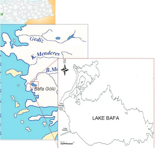
Lake Bafa is a saline-brackish wetland ecosystem of international importance located at the south-eastern part of Büyük Menderes River Delta (see Figure 1). It’s enclosed by Beşparmak Mountains at the south and east, alluvial plains of Büyük Menderes Delta at the north and west. The Lake’s surface area is 6708 hectares for 25 m depth. The average water level is 5 meters and its main recharging inlet is Büyük Menderes River. Beside this, some small streams contribute to the water input (Magnin and Yarar, 1997). A hydraulic barrier controlling the lake’s water level with two regulators at both ends have been installed.
The Lake was formed as the result of delta progradation of Büyük Menderes (Maeander) River. In the past six or so millennia, the river sediments have gradually infilled nearly the whole marine embayment of the so-called Latimian Gulf, thereby separating its southeastern part from the open sea
(Müllenhoff et al., 2004). During the past millennia, the marine embayment has been transformed into a delta and alluvial plain (Bay and Schröder, 1998; Brückner et al., 2006). The sedimentation rate in the late Hellenistic and Roman eras was accelerated by 6 times (135 cm/100 years) as compared to the timespan before and after. The reason for the enormous increase in sediment supply is ecologically unwise land use, particularly in Roman times. Deforestation of the hinterland led to strong erosion in the vicinities of Latmian Gulf (Müllenhoff et al., 2004).
Büyük Menderes River which is the longest river in the Aegean region meanders for 584 km through western part of Turkey before reaching the Aegean Sea with a large delta ecosystem. Büyük Menderes has a total drainage area of 2,4 Million hectares (Kazancı and Dügel, 2008). The overall runoff capacity, i.e. the erosion potential of the river is so high that, it could be able to change the geomorphology of the former Latmian Bay radically. Brückner et al. express that archaeological settlements such as Miletus, Priene, Myous and Herakleia were built on the shores of Latmian Gulf, which was formed due to the rise of the sea level in the late Pleistocene to early Holocene. According to Brückner et al., the decline of these cities was closely related to progradation of Büyük Menderes River delta (Brückner et al., 2006).
However this sediment accumulation is accelerated in the last millennium with increasing anthropogenic activity. Increased siltation by Büyük Menderes flow and gradual integration of Milesian Peninsula into the floodplain occurred between 4th-14th centuries. This process is finalized
with definite sediment accumulation at all parts of the bay and total loss of access to the open sea in the last 500 years (Brückner et al., 2006).
In 1985, State Hydraulic Works (DSI), the responsible institution of hydraulic infrastructures in Turkey, built a flood prevention barrier and two associated regulators at the north-western shore of the Lake. By means of these regulators, DSI started to control Lake’s level according to the flows of Büyük Menderes River. The main purpose of this project was not only to maintain the water levels of the Lake but also to decrease its salinity. This project is defended by DSI as an important progress to maintain the lake’s hydrochemical character while controlling it as a reservoir. According to DSI, the project would improve the water quality, the natural life and the ecological balance of the Lake in time (Koç, 2008). However, these two regulators which were thought to be inlet-outlet points of the lake for a clockwise circulation had some side effects on the ecological functions of the lake.
This system has been operated for 20 years without major ecological controls. During these years, some researchers realized significant works on the hydrochemical behaviour of Lake Bafa. Balık and Ustaoğlu, 1989; Cirik et al., 1989; Dügel and Kazancı, 2004; Sarı et al., 1997; Yılgör and Yaşar, 2009, all were focused on essential hydrochemical parameters and basic pollution indications. The common concern of these studies was the negative impact of the polluted Büyük Menderes River on Lake’s water quality. Although they all concluded that the salinity of the lake and the nutrient-heavy metal load brought by the river were major threats on the lake ecology, there were significant differences among their findings. As an example, Balık and Ustaoğlu (1989) and Cirik et al. (1989) found the dissolved oxygen values as 9,79 mg/l and 6,00 mg/l respectively for summer period. Similarly, their salinities were 4,48 % and 7,50 % (Balık and Ustaoğlu, 1989; Cirik et al., 1989). These differences even in the same sampling period raised the doubts about the system behaviour.
A mass fish mortality happened in 2006. Thousands of dead fish were observed at the north-eastern shore of the lake. They were all small demersal fish such as Gobius niger and Atherina boyeri. Because of the proximity of the lake to the popular touristic destinations such as Didim and Bodrum, this mass mortality of fish found place in national media as an ecological disaster. Thus, all responsible governmental bodies such as State Hydraulic Works (DSI), Ministry of Agriculture and Ministry of Environment & Forestry came into action separately. Preliminary findings were announced soon and diagnosis was the toxic effect of heavy metal load brought by Büyük Menderes River. However, some waterfowl species known as ecological indicators were eating those dead fish and this observation made us thinking about other scenarios.
2. Method
The disaster soon became mediagenic and the public concern turned into a scientific pressure towards a systemic assessment of the actual situation. Thus, the General Directorate of Nature Conservation and National Parks, responsible of the area because of the Nature Park status, initiated a research campaign in order to make a realistic diagnosis.
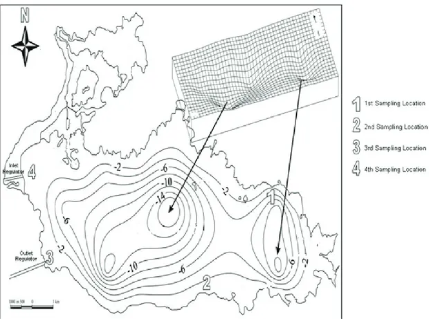
In our study, the first step was to identify geologic-geomorphologic characteristics of the lake which can affect other ecologic parameters. Recent studies proved that the geomorphology, i.e. the bathymetry of the Lake Bafa is not uniform. The bottom topography of the lake differs depending on the location. Two major depression and their associated crests form a significant irregularity at the bottom of the lake. Although DSI argues that two regulators create a clockwise water movement, this topographic anomaly can prevent the circulation of water throughout the lake. Thus the bathymetry of Lake Bafa has been studied in details. At this stage, the bathymetric map of the lake which was prepared by Doğdu (2007) has been used (see Figure 2).
In the second step, previous hydrochemical studies have been evaluated. Although numerous researchers implemented sampling-monitoring programs on the site, few of them could be used for comparison. The choice for the relevant works is made according to their sampling locations. Here the most reliable study seemed to be the Long Term Development Plan of Lake Bafa Nature Park, taking
the bottom topography into consideration. Then our sampling locations have been chosen to reflect similar conditions of the Plan’s study.
In the framework of the sampling-testing program, in-situ measurements of pH, electrical conductivity (EC), dissolved oxygen (DO), salinity and temperature (T) have been realized in four representative location. Beside this, water samples have been collected in order to determine nutrient loads and heavy metal concentrations such as Al, As, B, Ba, Cd, Co, Cr, Cu, Fe, Hg, Mn, Na, Ni, Pb, Se and Zn. The sampling-measurement program has been implemented by the reference laboratory of the Ministry of Environment and Forestry. All in-situ measurements and analyzes have been done according to the Standard Methods for Examination of Water and Wastewater, 21st Edition, 2005.
Some waterfowl species are known as indicators in assessing ecological changes in wetland ecosystems. The presence or absence of a species in any given area can indicate the existence or absence of certain environmental conditions in that same area (Won-Jin and Moores, 1998). In this context, some waterfowl species and their behaviours have been observed in order to check our findings. Beside these analyzes and observations, physical conditions such as wind, water level changes and human interventions to the natural functions have been assessed with a systemic approach.
Figure 2. The Bathymetric map and sampling locations (Modified after Doğdu, 2007).
3. Results
As it was mentioned above, the lake has a non-uniform bottom topography. According to Doğdu (2007), there are two deep depressions in the lake. The average depth of these basin-like cavities reaches to 25 meters and they have a significant effect on the water movement. Although two
regulators controlling the water level were built by DSI to create a clockwise circulation, these basins seem to be important obstacles for such an auto-purification system. Beside this, the authorities express that these regulators are not being operated according to a plan which has to take the bathymetric and hydrochemical characteristics into consideration. The inlet point, i.e. Büyük Menderes River regulator lets the water into the lake in case of high flow or flood. Such a situation occurs to establish a balance between the lake and the sea at outlet regulator too. Here the impossibility of maintaining a stable chemical structure in the lake is obvious. This lack of a determined hydrochemical structure and contribution of undulating bottom topography seem to be major reasons of significant differences between findings of different studies.
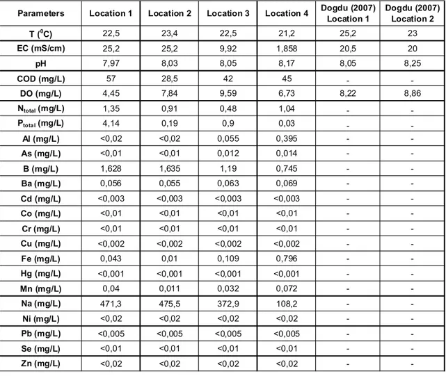
Table 1. Results of the analyses and measurements with comparison to Dogdu (1997) insitu tests.
The results of the analyses and in-situ measurements can be seen in Table 1. As one can see, the temperatures and pH values are almost in the same level for all measurement points. However DO values of Location 1 and Location 2 differ sharply from those of Location 3 and 4. Especially in Location 1 where all dead fish were found, DO (4,45 mg/L) is quite below the lowermost limit value (7,5 mg/L) for natural ecosystems in Turkish Legislation. It must be indicated that, this low value represents DO of the water surface. It means that this must be compared to Dogdu’s value of 8,22 mg/L. In the literature, different DO concentrations varying between 7,00 and 8,66 mg/L can be seen. However these values couldn’t be used in our assessments since their measurement points are not
Parameters Location 1 Location 2 Location 3 Location 4 Dogdu (2007) Location 1 Dogdu (2007) Location 2
T (0C) 22,5 23,4 22,5 21,2 25,2 23 EC (mS/cm) 25,2 25,2 9,92 1,858 20,5 20 pH 7,97 8,03 8,05 8,17 8,05 8,25 COD (mg/L) 57 28,5 42 45 - -DO (mg/L) 4,45 7,84 9,59 6,73 8,22 8,86 Ntotal (mg/L) 1,35 0,91 0,48 1,04 - -Ptota l (mg/L) 4,14 0,19 0,9 0,03 - -Al (mg/L) <0,02 <0,02 0,055 0,395 - -As (mg/L) <0,01 <0,01 0,012 0,014 - -B (mg/L) 1,628 1,635 1,19 0,745 - -Ba (mg/L) 0,056 0,055 0,063 0,069 - -Cd (mg/L) <0,003 <0,003 <0,003 <0,003 - -Co (mg/L) <0,01 <0,01 <0,01 <0,01 - -Cr (mg/L) <0,01 <0,01 <0,01 <0,01 - -Cu (mg/L) <0,002 <0,002 <0,002 <0,002 - -Fe (mg/L) 0,043 0,01 0,109 0,796 - -Hg (mg/L) <0,001 <0,001 <0,001 <0,001 - -Mn (mg/L) 0,04 0,011 0,032 0,072 - -Na (mg/L) 471,3 475,5 372,9 108,2 - -Ni (mg/L) <0,02 <0,02 <0,02 <0,02 - -Pb (mg/L) <0,005 <0,005 <0,005 <0,005 - -Se (mg/L) <0,01 <0,01 <0,01 <0,01 - -Zn (mg/L) <0,02 <0,02 <0,02 <0,02 -
-identified. Anyway, their results are presented in Table 2. From all points of view, DO concentration which we measured in Location 1 is a critical value. Beside this, Dogdu makes an emphasis on the sharp decrease in DO values with depth and measures 4,90 mg/L for -10 m from surface. Thus, it can be assumed that at the time of measurement, DO value in the eastern basin had to be lower than our measurement.
The second important finding covers the high total nitrogen and phosphorus values (1,35 mg/L, 4,14 mg/L) of Location 1. These concentrations are significantly high than those of the accepted tolerable limits of 0,1 mg/L and 0,005 mg/L consecutively (MoEF, 2004). Dügel and Kazancı (2004) express that Büyük Menderes River is organically polluted by evaluating their nitrite nitrogen concentrations between 0,03-1,05 mg/L. These high nitrogen and phosphorus values of Location 1 representing the eastern bottom pit of the Lake, connote a nutrient accumulation. As this depression might act as a material trap, its degree of eutrophication can differ from other parts of the lake. Thus a possible algal bloom in the eastern basin can be seen as the reason of a sudden mass mortality when it’s thought together with the deficient values of dissolved oxygen.
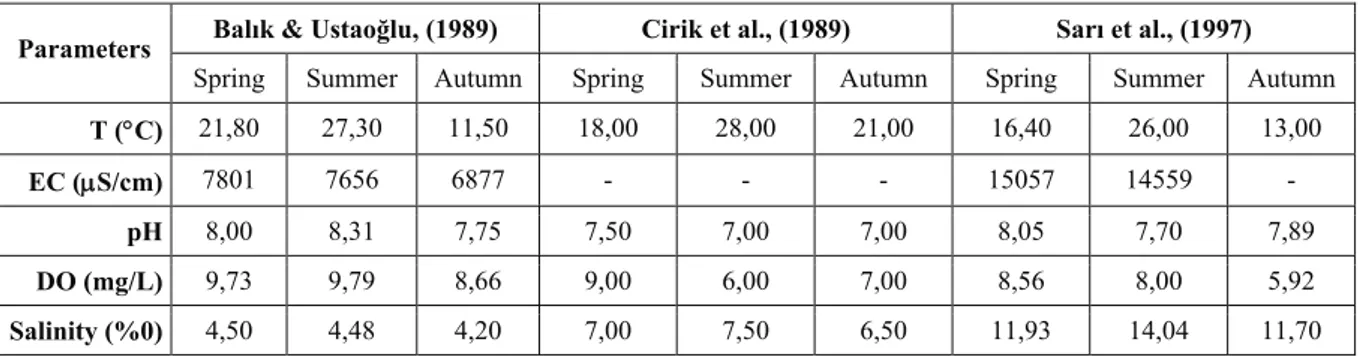
It’s observed that two regulators installed to control water levels are being used without taking the Lake’s water chemistry into consideration. The inlet regulator (freshwater entrance from Büyük Menderes River) is being operated in order to decrease salinity of the lake or to maintain lake’s water level. A similar use is valid for outlet regulator too. But it’s a fact that sea water can use this channel as the entrance in case of low water level in the lake. This random recharge from the sea creates a lagoon-like ecosystem. The significant differences of salinity or EC in time are proofs of this irregular use. EC values of 6,87 mS/cm (Balık and Ustaoğlu, 1989), 22,15 mS/cm (Kazancı et al.,2008 – measurement date 1996-), 14,56 mS/cm (Sarı et al., 2001 –measurement date 1997-), 25,2 mS/cm (this study), 20,5 mS/cm (Doğdu, 2007) clarify that the lake cannot have a stable chemical composition. It’s obvious that this disorder would have a negative impact on aquatic fauna of Lake Bafa.
Table 2. Basic parameters measured by various researchers (Modified after Sarı et al., 2001). Balık & Ustaoğlu, (1989) Cirik et al., (1989) Sarı et al., (1997) Parameters
Spring Summer Autumn Spring Summer Autumn Spring Summer Autumn
T (°C) 21,80 27,30 11,50 18,00 28,00 21,00 16,40 26,00 13,00
EC (μS/cm) 7801 7656 6877 - - - 15057 14559 -
pH 8,00 8,31 7,75 7,50 7,00 7,00 8,05 7,70 7,89
DO (mg/L) 9,73 9,79 8,66 9,00 6,00 7,00 8,56 8,00 5,92
Salinity (%0) 4,50 4,48 4,20 7,00 7,50 6,50 11,93 14,04 11,70
During our field study, a big variety of waterfowl was observed throughout the lake with large numbers. Among these, there were some species that one can get help as ecological indicators. It’s assumed that there had to be some disorders (dead birds or absence of waterfowl) in terms of ornithofauna too. On the contrary, Little Grebe Tachybaptus ruficollis (200-250), Grey Heron Ardea
cinerea (15-20), Little Egret Egretta garzetta (15-20), Kingfisher Alcedo atthis (4-5), Cormorant Phalocrocorax carbo (>50), Pygmy Cormorant Phalocrocorax pygmeus (>10), Little Gull Larus minutus (>100) and Yellow-legged Gull Larus cachinnans (>100) were observed with significant
numbers. Beside this, the local people told that the gulls were eating those dead fish since their first appearance. But there were no dead birds.
4. Conclusion
All these findings and observations yield to a human induced ecological response. The irregular use of the regulators without a determined plan taking all hydrochemical parameters into consideration gives rise to an unstable chemical composition. All interventions made to control the salinity of the lake cause side effects in other parameters such as dissolved oxygen, pH and the nutrient load having fatal importance for aquatic biota.
It seems that the freshwater coming from Büyük Menderes River brings its nutrient load and other associated compounds to the lake. Although the subsurface saltwater intrusion and the sea water input from the outlet regulator dilute this nutrient concentration, two depressions at the bottom of the lake act as nutrient traps and cause an organic accumulation. The crest separating the eastern pit from the western part is preventing an overall circulation, thus the dilution of nutrient concentrations. The analyze results of Location 1 representing the eastern pit are proofs of this topographic impact.
Regarding our scenario, this accumulation yielded to a sudden algal bloom and then a sudden sharp decrease in dissolved oxygen levels. It’s obvious that DO deficiency had lethal effect in the depth where oxygen concentrations were much lower. The species as the subject to this mass mortality are supporting this idea; they were all demersal fish such as Atherina boyeri and Gobius niger. At the rest of the lake, no dead fish was observed and those around the sampling Location 1 were being eaten by gulls.
Some heavy metals such as Ba, B, Fe or Mn were detected with high concentrations. However foregoing findings made us focusing mainly on oxygen deficiency rather than an inorganic intoxication.
During this disaster, the increase in salinity and heavy metal concentrations were blamed. Then authorities suggested flushing the lake by opening the inlet regulator. However our findings show that such a solution would only be the cause of a future algal bloom. To solve the organic pollution problem at the source, i.e. at Büyük Menderes River and to operate these regulators by accepting the lake as a living organism are unavoidable.
Our suggestion is to prepare an ecological model taking all aquatic biota, their interactions and their habitat needs into consideration together with physical and chemical characteristics of Lake Bafa. In the absence of such a model, it will be impossible to prevent the recurrence of these ecological disasters. This case also is a proof of deficiency of analytical approaches in ecosystems. The ecological integrity and systemic structure of the nature has to be taken into consideration by all decision makers. The ecosystem approach has to be embraced not only by conservation side of the governments but also by all other sectors.
5. Acknowledgement
The author wishes to express his gratitude to Filiz Korkmaz, biologist and Mehmet Boztepe, technician of the Environmental Reference Laboratory of Turkish Ministry of Environment & Forestry for their contributions. He also wishes to thank to the authorities of the General Directorate of Nature Conservation and National Parks for their supports.
References
Anonymous 2005. Standard Methods for the Examination of Water and Wastewater. American Public Health Association (APHA), American Water Works Association (AWWA) and Water Environment Federation (WEF), 21st Edition, 1368 pp.
Anonymous 2004. The Regulation of Water Pollution Control. Ministry of Environment and Forestry. Official Gazete, December 31, 2004, No. 25687.
Balık, S. and Ustaoğlu, M.R. 1989. Bioecological and economical investigation of Ulubat fish (Acanthobrama mirabilis Ladiges, 1960) in Lake Bafa, Doğa TU Zooloji D, 13 (3):141-174 (in Turkish).
Bay, B. and Schröder, B. 1998. Human induced soil erosion and delta progradation in the Grand Menderes Valley (SW-Turkey), Department of Geosciences, Ruhr-University Bochum, Germany. Poster presentation. (http://www.ruhr-uni-bochum.de/milet/in/geo-meandr/meander.pdf - accessed February 4th, 2010)
Brückner, H. Müllenhoff, M. Gehrels, R. Herda, A. Knipping, M. and Vött, A. 2006. From Archipelago to Floodplain-Geographical and Ecological Changes in Miletus and Its Environs During the Past Six Millenia (Western Anatolia, Turkey), Z. Geomorph. N.E, Suppl.Vol. 142: 63-83.
Cirik, S. Cirik, Ş. and Metin, C. 1989. Bafa Gölü Planktonik Algleri ve Mevsimsel Değişimleri, Çevre Sempozyumu, 8-9 Haziran 1989, Adana, Turkey: 604-613 (in Turkish).
Doğdu, M.Ş. 2007. II.4. Hidrojeolojik Yapı ve Limnolojik Özellikler, in: Bafa Gölü Tabiat Parkı Uzun Devreli Gelişme Planı, Analitik Etüd ve Sentez Raporu, AKS Planlama Ltd. Şti, Doğa Koruma ve Milli Parklar Genel Müdürlüğü: 66-97 (in Turkish).
Dügel, M. and Kazancı, N. 2004. Assessment of Water Quality of the Büyük Menderes River (Turkey) by Using Ordination and Classification of Macrovertabrates and Environmental Variables. Journal of Freshwater Ecology, 19(4): 605-612.
Kazancı, N. and Dügel, M. 2008. Prediction of global climate change impact on structure of aquatic insect assemblages by using species optimum and tolerance values of temperature. Review of Hydrobiology, 2: 73-80.
Koç, C. 2008. The Effects of the Environment and Ecology Projects on Lake Management and Water Quality. Environ Monit Assess, (146): 397-409.
Magnin, G. and Yarar, M. 1997. Important Bird Areas in Turkey. Doğal Hayatı Koruma Derneği, İstanbul, Turkey, pp 78-80. Müllenhoff, M. Handl, M. Knipping, M. Brückner, H. 2004. The evolution of Lake Bafa (Western Turkey) –
Sedimentological, microfaunal and palynological results, Coastline Reports 2004/1: 55-66.
Sarı, H.M. Balık, S. Özbek, M. Aygen, C. 2001. The Macro and Meiobenthic Invertabrate Fauna of Lake Bafa. Anadolu University Journal of Science and Technology. 2(2):285-291.
Won-Jin, Y. and Moores, N. 1998. Woopoo Wetland: A Preliminary Investigation With Relevance to Existing and Future Development Proposals. Environmental Research Institute, Kynugnam Univ, 21: 57-72.