First record of beachrock on Black Sea coast of Turkey: Implications for
Late Holocene sea-level
fluctuations
Ahmet Evren Erginal
a,⁎
, Yunus Levent Ekinci
b, Alper Demirci
b, Mustafa Bozcu
c,
Muhammed Zeynel Ozturk
d, Mustafa Avcioglu
c, Erdal Oztura
ea
Ardahan University, Department of Geography, TR-75000 Ardahan, Turkey
b
Çanakkale Onsekiz Mart University, Department of Geophysical Engineering, TR-17020 Çanakkale, Turkey
c
Çanakkale Onsekiz Mart University, Department of Geology Engineering, TR-17020 Çanakkale, Turkey
d
Çanakkale Onsekiz Mart University, Department of Geography, TR-17020 Çanakkale, Turkey
eÇanakkale Onsekiz Mart University, Department of Geography Education, TR-17020 Çanakkale, Turkey
a b s t r a c t
a r t i c l e i n f o
Article history: Received 9 May 2013
Received in revised form 14 June 2013 Accepted 15 June 2013
Available online 24 June 2013
Editor: Dr. J. Knight Keywords: Beachrock Sequential cementation Sea-level changes Thrace Black Sea
We present new data on the diagenetic characteristics, subsurface nature and radiocarbon ages of beachrock from the Thracian Black Sea coast of Turkey, indicative of sea-level changes and climatic conditions favoring lithification of beach sands between 5.4 ka and 3.5 ka cal BP. Micrite coatings and succeeding meniscus ce-ments typify diagenetic history and suggest a two-stage cementation over this timeframe. The early cece-ments are typical of upper intertidal zone when the sea-level was likely similar to that of today. The ensuing intergranular bridges refer to an approximate 2 m decline in sea-level, favoring downward percolation of meteoric waters related to subaerial exposure, marked by a reduction in Mg concentration and dissolution pits on early cement coatings. Formation of beachrock during this bimillennial period could be associated with relatively drier conditions promoting the precipitation of connective cements.
© 2013 Elsevier B.V. All rights reserved.
1. Introduction
As a kind of cemented beach deposit frequently found in the form of blocks or slabs, beachrock offers a record of the morphodynamic, climatic and oceanographic changes that have occurred in coastal areas. Amalgamation of sediments as well as fossil shells and micro-fossils entombed within cement or intergranular spaces provide a re-cord of the diagenetic history of the beachrock. Since the very earliest studies, attempts have been made to pinpoint the origin, age, distri-bution and significance of beachrock on various coastal outcrops around the world (seeVousdoukas et al. (2007)and references there-in). Since abiotic cement, i.e., aragonite and high Mg-calcite, is precip-itated as a direct result of the evaporation of sea-water, predominantly as a connective carbonate, beachrock has been generally attributed to intertidal cementation and regarded as giving explicit indications of sea-level changes. Nevertheless, contribution of different specific pro-cesses regarding to precipitation of binding carbonates have been sug-gested (Vieira and De Ros, 2006 and references therein). Until recently, however, there was debate on the credibility of beachrock
as a key indicator for sea-level changes due to differing viewpoints (Kelletat, 2006; Knight, 2007).
In contrast to authors who have focused on geomorphological data (Kelletat, 2006), many researchers have recently gained benefit from studying cementation characteristics (Kneale and Viles, 2000; Hillgaèrtner et al., 2001; Calvet et al., 2003; Rey et al., 2004; Vieira and De Ros, 2006) and stable isotope data (Holail and Rashed, 1992; Calvet et al., 2003; Friedman, 2005; Vieira and De Ros, 2006). One of the main problems regarding the solidity of intertidal beachrock in real terms is lack of information on the continuation of beachrock backshore under beach materials, since samples are mostly taken from slabs exposed at the coast. Along the 8333 km-long coastline of Turkey, beachrocks display a wide distribution, from the eastern end of the Mediterranean to the Gulf of Saros, comprising the northern limit of the Aegean Sea (Avşarcan, 1997; Desruelles et al., 2009).
In this study, results obtained from thefirst recorded beachrock on the Thracian Black Sea coast of Turkey are discussed (Fig. 1a, b). We considered that the formation of beachrock on the coast of the Black Sea is substantive in that this anoxic sea is presently characterized by low (17–20‰) surface salinity and a nominal amount of evaporation compared to the much greater amount of freshwater input by precipita-tion and rivers (Beşiktepe et al., 1994; Mertens et al., 2012). Based on diagenetic characteristics in conjunction with radiocarbon ages and
Sedimentary Geology 294 (2013) 294–302
⁎ Corresponding author. Tel.: +90 478 2114132; fax: +90 478 2113275. E-mail address:[email protected](A.E. Erginal).
0037-0738/$– see front matter © 2013 Elsevier B.V. All rights reserved.
http://dx.doi.org/10.1016/j.sedgeo.2013.06.003
Contents lists available atScienceDirect
Sedimentary Geology
geophysical imaging data, newfindings in respect of Late Holocene sea-levelfluctuations on the Turkish Black Sea coast are presented.
2. Study area
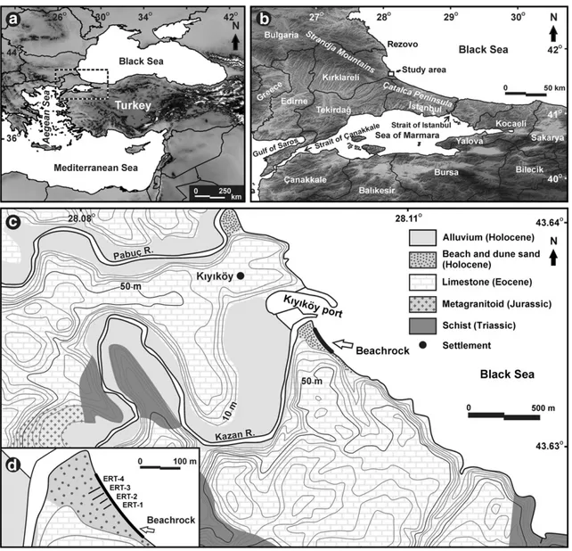
On the eastern coast of Kıyıköy, Kırklareli, NW Turkey, the studied deposits constitute thefirst record of beachrock from the northwestern Thracian Black Sea coast of Turkey (Fig. 1a, b). Comprising the European part of the country, Thrace is bounded by the Sea of Marmara to the south and Black Sea to the north and has a coastline of about 786 km. The Black Sea coast of Thrace starts from the mouth of the River Rezve (Rezovo) at the Bulgarian border and extends in a northwest–southeast direction down to the strait of Istanbul (Bosphorus) (Fig. 1b). The eastern part of Thrace comprises the Çatalca Peninsula and is character-ized by a nearly straight coastline. However, in the northwestern section, the Thracian coast is rather indented as the coastal area forms a seaward (northeast) prolongation of the Strandja Mountains, a massif consisting of basement rocks such as gneiss and amphibolite, and cover deposits formed of schist, limestone, sandstone and igneous rocks (Pamir and Baykal, 1947).
The geology of the backshore at the southern end of the cemented beach in this study is composed of Middle to Late Eocene fossiliferous limestones with sandstone and claystone intercalations (Fig. 1c). On
the northern coast is the mouth of the Kazandere River whichflows into the sea from between Kıyıköy port and a coastal spit (Fig. 1c). On the backshore, a low ridge made up of a 5-m thick coastal dune stands between the river mouth and the present sandy beach. Meteoro-logical data (1975–2006) from Kumköy meteorology station 85 km to the southeast indicate that the area receives a yearly precipitation of 831.4 mm. The average annual air and sea-water temperatures were recorded as 13.8 °C and 14.3 °C, respectively. During the hot period be-tween May and September, evaporation values from sea water reach a total of 600 mm, which is lower than the Mediterranean (approximate-ly 2000 mm). Climatical(approximate-ly, a humid-temperate Black Sea climate domi-nates (Türkeş, 1996). Tidal range is nominal with an average of 10 cm (Goudie, 2001).
3. Methods
3.1. Analyses of beachrock materials
Five samples of beachrock were collected for analysis and radio-carbon dating. Petrographic analysis was carried out based on thin section interpretations. Energy Dispersive Spectroscopy (EDX-Bruker AXS XFlash) analysis of the beachrock was performed to shed light on elemental composition of connective cements. Using Scanning Electron
Microscopy (SEM-Zeiss EVO 50 EP), the same sub-samples were used for determination of sequential cement fabrics on and around the bond-ed grains. Analysis was carribond-ed out at Izmir Institute of Technology, Turkey. To determine foraminiferal contents, samples were treated with 10% H2O2for one day and wet sieved through a 63μm sieve. The residue was then dried in air. In the sediment fraction above the 63μm sieve, benthic foraminiferal fauna was examined under a binocular mi-croscope. Five bulk samples of beachrock were dated by conventional and AMS radiocarbon methods at BETA, Miami, USA.
3.2. Geophysical survey
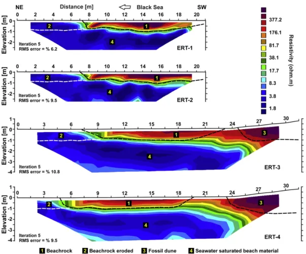
A geoelectrical survey using electrical resistivity tomography (ERT) technique was conducted along 4 coastline-perpendicular lines (Fig. 1d), 10 m apart from each other, in order to depict the internal structure and contact relationship of the beachrocks and also to monitor their landward extent. The ERT measurements were carried out with a GF ARES multi-electrode resistivity-meter system using dipole–dipole electrode configuration. Apparent resistivity data were collected from the beach using 22 electrodes spaced at 1 m for ERT-1 and ERT-2, and 1.5 m for ERT-3 and ERT-4. The total number of data levels was 11 for each survey line. Quality enhancement of the measured data was carried out by performing 6 stacks (repeated measurements) in each data point, and average apparent resistivity values were assigned to related datum points. Measured apparent resistivity data were then processed by an automatic 2D tomographic inversion scheme based on smoothness-constrained least-squares algorithm (Loke and Barker, 1996), for a more accurate interpretation. There were no topographic differences along the survey lines of ERT-1 and ERT-2. However, due to the significant topographic relief at the end of the lines of ERT-3 and ERT-4, elevations of each electrode location were measured and the topographical data were incorporated into the 2D inversion proce-dure in order to carry out more detailed and reliable processing. The cal-culated apparent resistivity data were obtained using thefinite-element method with four nodes per unit electrode spacing during the inversion process. Forfinal interpretation, geoelectrical resistivity tomograms were chosen at the iteration after which RMS error did not change significantly.
4. Results and discussion
4.1. Morphology and subsurface nature of beachrock
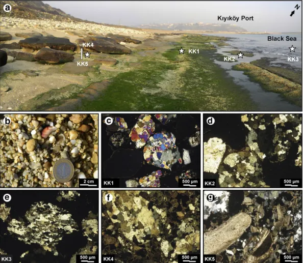
Similar to the orientation of the present beach, the beachrock beds extend in a northwest–southeast direction to the south of a coastal spit stretching toward Kıyıköy Port (Fig. 2a). Visible thickness of the exposed beds ranges between 10 cm and 75 cm. The length and width of the beds are 250 m and 20 m, respectively. Dipping toward the sea at angles between 5° and 10°, the beds are composed of hard-bonded coarse sands with sizes ranging between 0.5 mm and 1 mm, veryfine gravels smaller than 3 cm and bivalvia fragments (Fig. 2b). Having a maximum visible thickness of 75 cm, many of the beds emerge from the 20-m wide sandy beach and are backed by iron-oxidized dune deposits with abundant fossil shells of Donax trunculus. Throughout the cemented zone, the surface of the beachrock and fractures enlarged by sea waves is substantially colonized by Enteromorpha sp. At the southeast end of the beach, the beachrock beds terminate in front of cliffs cut in Middle–Upper Eocene lime-stones mostly composed of overlapping broken blocks due to violent sea-wave erosion. These blocks, up to 3 m in size, appear to have dis-sected along fracture sets of orthogonal and polygonal joints. Given that the studied coast is tectonically dormant, these fractures may be supposed to be of syndepositional origin, showing a lack of any tectonically-induced displacement along the studied coast.
Even though the visible thickness of the emerged beachrock is about 75 cm, the seaward margin of the submerged beachrock at a
depth of−2 m extends up to 20 m offshore. Following the assump-tion that beachrock is suggestive of intertidal cementaassump-tion, and its po-tential for highlighting sea-level changes, knowledge of the total thickness of beds, including buried slabs, is of importance. For this purpose, ERT images (Fig. 3) were obtained from the beach. Taken perpendicular to the coastline (Fig. 1d), resistivity tomograms pro-duced by the 2D tomographic inversion process displayed a depth range of about 2.7 m for ERT-1 and ERT-2 and about 4 m for ERT-3 and ERT-4 (Fig. 3). The resistivity values in the survey area vary between about 1 and 550 ohm.m. Thus, the tomographic images clearly show a sharp resistivity contrast between the high-resistivity beachrocks and high-conductivity beach material. The abnormal decrease in the resistivity values of the beach material might have resulted from an in-crease in salinity due to seawater intrusion. These images also show that the buried slabs of beachrock are about 1 m thick, showing a sharp termination at this depth. Additionally, a high-resistivity zone is observed at the end of ERT-3 and ERT-4 lines. This high-resistivity zone is thought to be associated with fossil dunes located on the backshore. According to ERT images, the buried beds are followed up to about 23 m at the backshore. At the beginning of the ERT lines, traces of the beachrocks are not observed probably due to erosion.
Geophysical imaging data provided two important insights into the beach environment cemented to form this beachrock; i.e., (1) a maximum thickness of beds of 1.75 m, exceeding the inconsiderable tidal amplitude of the Black Sea (Goudie, 2001), when exposed and buried slabs are taken into consideration, and (2) the total width of the cemented zone (about 40 m), including the submerged parts off-shore and buried onoff-shore parts.
4.2. Composition and diagenetic stages
A coastal conglomerate predominated by small pebbles and coarse sands in grain size distribution, the studied beachrock contained calcium carbonate of between 34 and 45%. The amalgamated compo-nents were poorly sorted, containing pebbles (48%) and sands (52%), the latter of which were composed mainly of very coarse sand (81%) andfiner grains. Pebbles smaller in size than 3 mm were predomi-nant, implying that the cemented beds arose from a higher-energy shingle beach. Broken shell fragments dominated by D. trunculus, Venus gallina and Patella sp. were observed to be tightly embedded solely on the case-hardened surface of beds. Petrographic analyses from thin sectioned images of thefiner parts indicate that the beachrock was composed of quartz arenite to sublitharenite based onFolk's (1974) classification, containing various rock fragments derived from granite, micaschist and quartzite as well as some algae (Fig. 2c–g). This composi-tion is indicative of derivacomposi-tion from the Strandja massif in the northwest which holds the basement rocks of Thrace. Thin section images showed that grains are, to a large extent, composed of weakly-bonded sands of sub-rounded polycrystalline quartz typical of short-distance drift by longshore coastal currents.
The benthic foraminiferal fauna within the samples consisted of number of species (Table 1) at varied amounts, the majority of which were recently reported from a cemented coquina to the east of the study area (Erginal et al., 2012). Predominance of Rosalina vilardeboana and Ammonia tepida within the samples indicates shallow water in re-spect of the depositional environment.
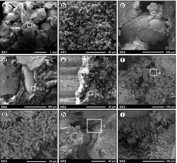
SEM analyses in conjunction with EDX undertaken to highlight the origin and diagenetic history of the beachrock indicated the presence of different cement fabrics (Fig. 4). These cements are composed, in order of priority, of micrite coatings and meniscus bridges formed exceptionally of radial aggregates and scalenohedral calcite rims. In decreasing order of abundance, cements measured by EDX (Table 2) contain, on average, O (49.64%), Ca (25.76%), C (12.98%), Si (5.15%), Mg (1.27%), Al (0.98%), Fe (0.31%) and Na (0.29%). Albeit at low concentrations, the presence of Al, Si and Fe in cements is likely related to involvement from the mineral fragments. These cements are composed
exclusively of low-Mg calcite (0.52–1.7 mol% MgCO3), suggesting the in-fluence of freshwaters. Such fabrics are known to dominate not only in beachrocks from temperate coasts (Kneale and Viles, 2000) but are also ascribed to freshwater diagenesis (Binkley et al., 1980). In this respect, it is essential to establish whether this cement was either low-Mg calcite, originally transported by downward-percolating carbonate-rich ground-waters from Eocene limestones at the backshore, or is associated with transformation from aragonite or high-Mg calcite to low-Mg calcite with the lapse of time (Siesser, 1974; Guerra et al., 2005). EDX analysis of the bedrock samples displayed a lack of Mg in their elemental concen-tration, being composed of C (18.6%), O (60%), Ca (20.3%), and Si (0.6%) (Table 2). Thus, neomorphic replacement from early cement to low-Mg calcite is not likely.
Containing 1.29 mol% MgCO3, micritic envelopes with a maximum thickness of 20μm were very common in all the analyzed samples, with a high void ratio (Fig. 4a, b). These cements were attached to siliciclastic grains (Fig. 4c, d), lithoclasts and, to a lesser extent, shell fragments. Constituting different orientations on their substrates, micrites are composed of equal-sized crystals with an average length of 4μm. Closer views of these coatings display the presence of micritic aggregates of low-Mg calcite (Fig. 4e). This fabric may be attributed to precipitation in the backshore by meteoric groundwater in the upper intertidal zone (Guerra et al., 2005).
These thin coatings are followed by bridging cements, i.e., meniscus fills connecting grains and lithic fragments (Fig. 4f). Lower than the for-mer, the low percentage of Mg calcite, with an average of 0.52 mol%, is indicative of precipitation from the mixing of sea water and meteoric waters or solely from the latter (Scoffin and Stoddart, 1983; Spurgeon
et al., 2003; Rey et al., 2004).Rey et al. (2004)suggest that the mixing of marine and meteoric waters results in an increase in the concentration of dissolved carbonates, in that increased pH makes carbonate precipita-tion easier. The existence of carbonates formed by Eocene limestones might have been a landward source of cement.
The width of the connecting bridges may reach 200μm. Closer ex-amination of meniscus cements displayed the presence of aggregates of calcite (1.45 mol% MgCO3) subjected to dissolution under subaerial exposure conditions (Fig. 4g). Albeit rare, the third form of cement binding siliciclastic grains is composed of low-Mg calcite rims consisting of clumps of reciprocal-oriented calcites having scalenohedral termina-tions (Fig. 4h, i). Contributing to building intergranular bridges, these rims are thinner than 50μm and follow 5-μm thick micrite envelopes. 4.3. Implications for Late Holocene sea-level changes
Radiocarbon dating of the bulk carbonates obtained from thefive samples was undertaken to date the formation of the beachrock sam-ples collected from three different sections; namely, the middle, backmost and leading edges. Results presented inTable 3yielded ages 5460 cal BP and 3500 cal BP for the oldest and the youngest beds, respectively. Extracted from a depth of 15 cm, the oldest sample (KK1) represents the middle section of the cemented beds, dated to 5460–5260 cal BP. Samples from the leading edges and backmost parts of beds are represented by the youngest calibrated ages of 3830–3570 cal BP (KK3) and 3760–3500 cal BP (KK4), respectively. This indicates that beds lying on the seaward side and outer (a few meters offshore) parts of beds are concurrent units in the sense of
Fig. 2. (a) View of studied beachrock. Stars indicate sampling locations. (b) Close up of cemented sands and bioclast on upper, case-hardened surface of beachrock. (c–g) Thin section images of beachrock with sample codes; (c) polycrystalline quartz grains within weakly bonded beachrock with very high void ratio; (d) typical example of meniscus ce-ment; (e) a quartzite fragment and weak meniscus bridges between the grains; (f) Polycrystalline quartz and meniscus cement following thin micritic coatings; (g) algae fragments.
deposition, as opposed to the belief that outer units manifest older generations of beachrock (Psomiadis et al., 2009). Two samples taken from the landward and seaward edges of slabs yielded very similar values of 4270–3970 cal BP (KK5) and 4210–3920 cal BP (KK2), respectively.
In view of middle to Late Holocene sea-level changes in the Black Sea, the ages obtained are of particular importance for the period spanning the last 5 ka. It is known that the Black Sea has been in equilibrium with the Mediterranean sea-level since their last reconnection at 7500 cal BP (Fouache et al., 2012). Since then, several authors have dealt with the sea-level history of the Black Sea (Brückner et al., 2010and references therein).
Superimposed curves illustrative of Holocene sea-levelfluctuations during the Holocene infer a rising sea-level trend with important fluctu-ations up to near 5 ka BP, then rises and falls thereafter in reference to the present-day (Martin and Yanko-Hombach, 2011). Regarding this
timeframe, the curves represent different magnitudes offluctuations before and after 5 ka BP from the perspective of ages acquired from beachrocks. For instance, the curves by Ostrovsky et al. (1977), Tchepalyga (1984), Voskoboinikov et al. (1982), Filipova-Marinova (2007)andBalabanov (2007)all agree on a decline varying between −2 m and −8 m at 5.5 ka BP, as againstNevessky's (1970)curve which demonstrates a remarkable descent near−25 m (Fig. 5). For the period when early marine-phreatic cements were precipitated at 5.4 ka, theFilipova-Marinova (2007)andBalabanov (2007)curves ap-pear to be the most plausible as they show a sea-level between 0 m and−2 m, which does not conflict with those proposed for the Eastern Mediterranean (Fouache et al., 2012). This is confirmed by data from the offshore delta lobes of the Danube (Giosan et al., 2006). On the basis of the optical age of beach ridge sands and14C ages of bivalves within them,Giosan et al. (2006)suggested that the sea-level in the
past 5 ka was between +1.5 m and−2 m.
From 5 ka BP to the present, the level of the Black Sea followed a more regular trend with lower-magnitudefluctuations. With regard to the time span between 4.2 ka and 3.5 ka when many of the beachrock slabs developed, the proposed curves display apparent contradiction. For ex-ample, variations of a few meters in proportion to the present sea-level illustrated byTchepalyga (1984)andVoskoboinikov et al. (1982)as well as the calibrated and uncalibrated curves ofFilipova-Marinova (2007)are at variance with the relatively regular regressive stage depicted in Ostrovsky et al. (1977)andBalabanov (2007). Furthermore, a remarkable short time regression around 500 BC is marked by a fall up to−10 m on all curves, which has been attributed to the postulated Phanagorian re-gression byFedorov (1963), criticized by Fouache et al. (2012)based on archeological, historical and hydrodynamic arguments.
With regard to the questions raised above, the bimillennial period spanning 5.5 ka BP and 3.5 ka BP matches the formation of the studied
Fig. 3. Interpreted inverse model resistivity tomograms taken perpendicular to the coastline.
Table 1
List of benthic foraminifera identified in the beachrock samples.
Sample code Foraminifera Number
KK1 Ammonia tepida 35 KK3 Ammodiscus planorbis 5 Patellina corrugata 2 Quinqueloculina sp. 1 Pseudotriloculina sp. 1 Rosalina vilardeboana 40 Rosalina sp. 1 Cibicides sp. 1 Ammonia sp. 1
KUM1 Ammonia parkinsoniana 6
Ammonia sp. 7
Elphidium macellum 20
Elphidium sp. 16
beachrock based on limiting age values. The aforementioned charac-teristics of cement fabrics in samples are suggestive of the initially precipitation of low-Mg calcite to form micritic coatings from meteoric
groundwaters in the backshore, followed by meniscus bridges and, to a lesser extent, rims of low-Mg calcite. This consecutive pattern is typical of the precipitation in upper intertidal and vadose zones. Observed
Fig. 4. SEM images from beachrock samples. (a–e) Thick micrite coatings. These coatings are typical in all samples; (a) all samples have high void ratio; (b) close-up view of white square in (a), showing that calcite surfaces are mostly marked by solution pits due possibly to percolated freshwaters during subaerial exposure of beachrock slabs; (c–e) another views of such envelopes; (e) closer view of the square in (d) demonstrating micritic aggregates with thickness of about 20μm; (f) typical image of meniscus cement; (g) closer view of bridge marked in square showing aggregates of calcite subjected to dissolution, as in (b); (h) low-Mg calcite rims; (i) rims binding juxtaposed siliciclastic grains are thinner than 50μm and composed of clumps of reciprocal-oriented calcite crystals with scalenohedral terminations.
Table 2
EDX analysis results obtained from beachrock cements.
Sample code Analyzed surface Elements (wt.%)
C O Na Mg Al Si Ca Fe MgCO3 (mol%) KK1 Micritic coating 11.54 50.34 0.5 1.74 2.49 3.92 28 1.5 1.4 KK1 Micritic coating 12.5 51.1 0.56 1.47 1.44 3.08 29.2 0.7 1.17 KK1 Micritic coating 11.09 49.37 0.5 1.63 2.01 3.77 30.5 1.1 1.33 KK2 Micritic coating 11.93 51.28 0.5 1.98 2 4.69 26.4 1.2 1.57 KK2 Micritic coating 13.3 52.67 – 2 0.74 3.74 27.5 – 1.56 KK2 Meniscus bridge 15.49 57.35 – – 3.43 4.83 18.9 – – KK3 Meniscus bridge 10.42 52.8 – 1.35 2.59 11.8 21 – 1.06 KK3 Micritic coating 13.64 51.64 – 1.77 – 1.31 31.6 – 1.39 KK3 Radial aggregates 11.63 49.1 – 1.48 – 2.78 35 – 1.21 KK4 Micritic coating 13.18 53.14 – 1.76 – 5.18 26.1 0.6 1.37 KK4 Radial aggregates 11.9 49.9 – 2.06 1.07 – 32.5 – 1.64 KK4 Meniscus bridge 15.4 60.53 – – – 13.4 10.7 – – KK4 Meniscus bridge 15.54 60.39 – – – 12.7 11.4 – – KK5 Micritic coating 12.48 50.75 1.7 – – 3.92 29.8 – – KK5 Meniscus bridge 14.2 53.92 0.97 1.07 – 4.97 23.5 – 0.82 KK5 Micritic coating 13.45 51.92 – 2.16 – 2.33 30.1 – 1.7
widely in all samples, the coexistence of dissolution on early micritic cements and minute concentrations of MgCO3within both cements are likely suggestive of diagenetic alteration by deeply percolated freshwaters.
In the present case, climatic conditions might have played an impor-tant role with respect to the precipitation of calcium carbonates during the evaporation-prone stages and thereby beachrock cementation. During the abovementioned timeframe, precipitation of amalgamating carbonates into loose beach sand prior to 3.5 ka would have been pro-moted by increased evaporation under drier conditions. Hence, based on recent data from the Sofular Cave records, the wet period of Holocene Climatic Optimum starting from 9.6 ka changed into a drier climate after 5.4 ka BP (Göktürk et al., 2011). Although no record is available for possible arid periods of the Black Sea to compare with the Eastern Mediterranean at 4500–3900 BP and 3100–2800 BP (Roberts et al., 2011), we might suppose that the rest of the samples dated at between 4.2 and 3.5 ka are possible indicators of such drier periods.
The lack of Emiliania huxleyi, recently documented from slightly younger-aged carbonate-cemented coquina on the southeastern Thracian Black Sea coast of Turkey (Erginal et al., 2012), also permits forecasting the cementation environment. This calcareous nannoplankton is notably abundant in surface waters of the Black Sea (Lancelot et al., 2002) and first appeared in this body of water about 3000 years ago when salinity prone to its adaptation reached 11‰ (Bukry, 1974). The absence of the coccolith E. huxleyi within all samples could be indicative of the fact that cementation took place prior to 3500 BP and did not continue thereafter. During the precipitation of connective carbonates just before the invasion of the Black Sea by E. huxleyi, on the lower boundary of ecozone 1 at 3300 BP (Giunta et al., 2007), water-salinity was below the tolerance limit of this coccolith.
Another argument associated with coastal processes matching the formation of beachrock arises from a relict coastal dune sequence on the backshore at the Kıyıköy location. The sandy beach is backed by a 3-m thick dune deposit consisting of polycrystalline quartz, epidote and plagioclase with coloration of opaque iron oxide rings. The sequence also includes fragments of ferro-magnesium minerals as well as poorly rounded metamorphic rock fragments derived from quartz–epidote– schist and marble. The bottom and middle levels of the sequence contain fossil shells of D. trunculus and V. gallina, the latter of which is present only in the middle level. The sequence is almost absent of foraminifera with the exception of the bottom level which incorporates Elphidium macellum, broken fragments of Elphidium sp., Ammonia parkinsoniana and other Ammonia sp.
From bottom to top, the total amount of CaCO3in this relict dune, decreases from 14% to 2%. Coarse and medium sands are predominant (95%). The rest of the dune deposit comprises veryfine sand and silt. All these components are weakly bonded by meniscus cement formed by iron-oxides. Besides being of similar composition to the beachrock, two shells of D. trunculus collected from the bottom and middle levels yielded AMS radiocarbon ages of 5440–5230 cal BP and 3230–2940 cal BP, respectively (Table 2). These ages, as well as the compositional attributes specified, are virtually identical to those of beachrock, suggesting that both occurrences are coeval. Nevertheless, this consolidated, well-drained and iron-oxidized dune deposit requires further study owing to its paleosoil-like characteristics.
5. Conclusions
The beachrock exposures in this study were observed on the northwest coast of East Thrace, Turkey. Albeit with a limited exposure,
Table 3
Radiocarbon ages of beachrock carbonates (KK) and bivalves recovered from fossil coastal dune (KUM) at backshore. For sample locations, seeFig. 2. Sample code Lab. code Material dated 14C yr BP
(measured age)
14C yr BP
(conventional age)
Calibrated age (yr BP) (2 sigma)a
δ13C/12C
(‰)
KK1 BETA-338674 Bulk carb. 4850 ± 30 4990 ± 30 5460–5260 −0.3
KK2 BETA-338675 Bulk carb. 3610 ± 40 4030 ± 40 4210–3920 +0.4
KK3 BETA-338676 Bulk carb. 3420 ± 30 3840 ± 30 3830–3570 +0.4
KK4 BETA-338677 Bulk carb. 3280 ± 30 3700 ± 30 3760–3500 +0.4
KK5 BETA-338678 Bulk carb. 3660 ± 30 4080 ± 30 4270–3970 +0.6
KUM3 BETA-338672 Shell 2850 ± 30 3250 ± 30 3230–2940 −0.6
KUM5 BETA-338673 Shell 4560 ± 30 4960 ± 30 5440–5230 −0.6
a
Calibration of samples based on calibration data base information (MARINE09 from INTCAL09) (Stuiver and Reimer, 1993; Reimer et al., 2009).
Fig. 5. Holocene sea-level curves for the Black Sea (partly modified fromMartin and Yanko-Hombach, 2011).
Data are based onNevessky (1970),Ostrovsky et al. (1977),Voskoboinikov et al. (1982),Tchepalyga (1984),Balabanov (2007)and
Filipova-Marinova (2007).
the studied beachrock is thefirst record from the Black Sea coast. The ages range between about 5.5 ka BP and 3.5 ka BP, a controversial period with regard to the Middle to Late Holocene sea-level history of the Black Sea. Predominating coarse grains and small pebbles in the cemented beds are indicative of the fact that the pre-cementation envi-ronment was a high-energy shingle beach backed by coastal dunes. These dunes are preserved as a relict dune sequence at the backshore and form a contemporaneous unit based on the AMS radiocarbon age of its bioclasts.
Our results revealed that the thickness of the beds, based on the geophysical imaging survey, exceeded the tidal range, implying that the cemented beach could not be simply of intertidal origin. Besides the existence of low-Mg calcite, the secondary cement-producing me-niscus bridges on early micritic cements and dissolution pits on micrite coatings are likely connected with freshwater penetration due to sub-aerial exposure of slabs when the sea-level was slightly lower than it is today. We assume that the cements were precipitated when Black Sea's salt content was lower than present, based on the absence of E. huxleyi. We suggest that the cements were first precipitated in the upper intertidal zone when the sea-level was close to the present. Beachrock formation continued during subaerial exposure of the whole sequence when the sea-level declined slightly (about−2 m), inasmuch as early cements have etched surfaces in consequence of downward-percolating meteoric waters.
Acknowledgments
Dr. Aydın Büyüksaraç is thanked for allowing us to use the resistivity-meter for this research. We would like to thank Dr. Elmas Kırcı-Elmas for her help with determination of foraminifera within beachrock samples. We wish to thank Mr. Graham Lee for correction of English text. We are also indebted to the Journal Editor Dr. Jasper Knight, and two anon-ymous referees for their constructive comments that have greatly im-proved our paper. This study was supported by the Scientific and Technological Research Council of Turkey (TÜBİTAK) (Project Number: 112Y217).
References
Avşarcan, B., 1997.Yalıtaşı oluşumu ile ilgili kuramlar ve Türkiye kıyılarındaki yalıtaşlarının bazı özellikleri. İ.Ü Coğrafya Dergisi 5, 259–282 (in Turkish with English abstract).
Balabanov, I.P., 2007.Holocene sea-level changes of the Black Sea. In: Yanko-Hombach, V., Gilbert, A.S., Panin, N., Dolukhanov, P. (Eds.), The Black Sea Flood Question: Changes in Coastline, Climate, and Human Settlement. Springer, Dordrecht, The Netherlands, pp. 711–730.
Beşiktepe, S., Sur, H.I., Özsoy, E., Latif, M.A., Oguz, T., Ünlüata, Ü., 1994.The circulation and hydrography of the Marmara Sea. Progress in Oceanography 34, 285–334.
Binkley, K.L., Wilkinson, B.H., Owen, R.M., 1980.Vadose beachrock cementation along a Southeastern Michigan marl lake. Journal of Sedimentary Petrology 50, 953–962.
Brückner, H., Kelterbaum, D., Marunchak, O., Porotov, A., Vött, A., 2010.The Holocene sea level story since 7500 BP— lessons from the Eastern Mediterranean, the Black and Azov Seas. Quaternary International 225, 160–179.
Bukry, D., 1974.Coccoliths as paleosalinity indicators— evidence from Black Sea. In: Degens, E.T., Ross, D.A. (Eds.), The Black Sea— Geology, Chemistry and Biology. Memoir American Association Petroleum Geologist, 20, pp. 353–363.
Calvet, F., Cabrera, M.C., Carracedo, J.C., Mangas, J., Pérez-Torrado, F.J., Recio, C., Travé, A., 2003.Beachrocks from the Island of La Palma (Canary Islands, Spain). Marine Geology 197, 75–93.
Desruelles, S., Fouache, E., Çiner, A., Dalongeville, R., Pavlopoulos, K., Koşun, E., Coquinot, Y., Potdevin, J.L., 2009.Beachrocks and sea level changes since Mid-Holocene: com-parison between the insular group of Mykanos–Delos–Rhenia (Cyclades, Greece) and southern coast of Turkey. Global and Planetary Change 66, 19–33.
Erginal, A.E., Ekinci, Y.L., Demirci, A., Kırcı-Elmas, E., Kaya, H., 2012.First note on Holocene coquinite on Thrace (Black Sea) coast of Turkey. Sedimentary Geology 267–268, 55–62.
Fedorov, P.V., 1963.Stratigrafija Krimsko-Kavkazskogo pobrezija I nekotorie voprosi geologicheskoi istorii Chernogo morja (Stratigraphy of Quaternary Deposits of Crimean–Caucasian Coastline and Several Questions of Geological History of the Black Sea). (Trudi GIN AN SSSR, Moscow. Science, tom. 88. [Transactions Geol. Inst. RAS. Moscow, Science 88]).
Filipova-Marinova, M., 2007.Archaeological and paleontological evidence of climate dynamics, sea-level change, and coastline migration in the Bulgarian sector of the circum-Pontic region. In: Yanko-Hombach, V., Gilbert, A.S., Panin, N., Dolukhanov, P.
(Eds.), The Black Sea Flood Question: Changes in Coastline, Climate, and Human Settlement. Springer, Dordrecht, The Netherlands, pp. 453–481.
Folk, R.L., 1974.Petrology of Sedimentary Rocks. Hemphill Publishing, Austin, Texas (184 pp.).
Fouache, E., Kelterbaum, D., Brückner, H., Lericolais, G., Porotov, A., Dikarev, V., 2012.
The Late Holocene evolution of the Black Sea— a critical view on the so-called Phanagorian regression. Quaternary International 266, 162–174.
Friedman, G.M., 2005.Climatic significance of Holocene beachrock sites along shorelines of the Red Sea. American Association of Petroleum Geologists Bulletin 89, 849–852.
Giosan, L., Donnelly, J.P., Constantinescu, S., Filip, F., Ovejanu, I., Vespremeanu-Stroe, A., Vespremeanu, E., Duller, G.A.T., 2006.Young Danube delta documents stable Black Sea level since the middle Holocene: morphodynamic, paleogeographic, and archeological implications. Geology 34, 757–760.
Giunta, S., Morigi, C., Negri, A., Guichard, F., Lericolais, G., 2007.Holocene biostratigraphy and paleoenvironmental changes in the Black Sea based on calcareous nannoplankton. Marine Micropaleontology 63, 91–110.
Göktürk, O.M., Fleitmann, D., Badertscher, S., Cheng, H., Edwards, R.L., Leuenberger, M., Frankhauser, A., Tüysüz, O., Kramers, J., 2011.Climate on the Southern Black Sea coast during the Holocene: implications from the Sofular Cave record. Quaternary Science Reviews 30, 2433–2445.
Goudie, A.S., 2001.The Nature of the Environment, 4th edition. Wiley-Blackwell, Oxford (560 pp.).
Guerra, N.C., Kiang, C.H., Sial, A.N., 2005.Carbonate cements in contemporaneous beachrocks, Jaguaribe Beach, Itamaracá Island, northeastern Brazil: petrographic, geochemical and isotopic aspects. Anais da Academia Brasileira de Ciências 77, 343–352.
Hillgaèrtner, H., Dupraz, C., Hug, W., 2001.Microbially induced cementation of carbonate sands: are micritic meniscus cements good indicators of vadose diagenesis? Sedimen-tology 48, 117–131.
Holail, H., Rashed, M., 1992.Stable isotopic composition of carbonate-cemented recent beachrock along the Mediterranean and the Red Sea coasts of Egypt. Marine Geology 106, 141–148.
Kelletat, D., 2006.Beachrock as a sea-level indicator? Remarks from a geomorphological point of view. Journal of Coastal Research 22, 1555–1564.
Kneale, D., Viles, H.A., 2000.Beach cement: incipient CaCO3-cemented beachrock
de-velopment in the upper intertidal zone, North Uist, Scotland. Sedimentary Geology 132, 165–170.
Knight, J., 2007. Beachrock reconsidered. Discussion of Kelletat, D., 2006. Beachrock as a sea-level indicator? Remarks from a geomorphological point of view. Journal of Coastal Research 22, 1558–1564. Journal of Coastal Research 23, 1074–1078. Lancelot, C., Staneva, J., Van Eeckhout, D., Beckers, J.-M., Stanev, E., 2002.Modelling the
Danube-influenced north-western continental shelf of the Black Sea. Part II: ecosystem response to changes in nutrient delivery by the Danube River after its damming in 1972. Estuarine Costal Shelf Science 54, 473–499.
Loke, M.H., Barker, R.D., 1996.Rapid least-squares inversion of apparent resistivity pseudosections using a quasi-Newton method. Geophysical Prospecting 44, 131–152.
Martin, R.E., Yanko-Hombach, V., 2011.Rapid Holocene sea-level and climate change in the Black Sea: an evaluation of the Balabanov sea-level curve. In: Buynevich, I.V., Yanko-Hombach, V., Gilbert, A.S., Martin, R.E. (Eds.), Geology and Geoarchaeology of the Black Sea Region: Beyond the Flood Hypothesis. Geological Society of America Special Paper, 473, pp. 51–58.
Mertens, K.N., Bradley, L.R., Takano, Y., Mudie, P.J., Marret, F., Aksu, A.E., Hiscott, R.N., Verleye, T.J., Mousing, E.A., Smyrnova, L.L., Bagheri, S., Mansor, M., Pospelova, V., Matsuoka, K., 2012.Quantitative estimation of Holocene surface salinity variation in the Black Sea using dinoflagellate cyst process length. Quaternary Science Reviews 39, 45–59.
Nevessky, E.N., 1970.Holocene history of the coastal shelf zone of the USSR in relation with processes of sedimentation and condition of concentration of useful minerals. Quaternaria 12, 78–88.
Ostrovsky, A.B., Izmaylov, Y.A., Balabanov, I.P., Skiba, S.I., Skryabina, N.G., Arslanov, S.A., Gey, N.A., Suprunova, N.I., 1977.Novie dannie opalegidrologicheskom rezhime Chernogo moria v verkhnem pleistotsenei golotsene (New data on the paleohydrological regime of the Black Sea in the Upper Pleistocene and Holocene). In: Kaplin, P.A., Shcherbakov, F.A. (Eds.), Paleogeografi ia i otlozheniia pleistotsena iuzhnykh morei SSSR. (Pleistocene Paleogeography and Sediments of the Southern Seas of the USSR). Nauka, Moscow, pp. 131–140 (in Russian).
Pamir, H.N., Baykal, F., 1947.Istranca masifinin jeolojik etüdü. MTA Rap., 2257 (in Turkish).
Psomiadis, D., Panagiotis, T., Konstantinos, A., 2009.Electrical resistivity tomography mapping of beachrocks: application to the island of Thassos (N. Greece). Environ-mental Earth Sciences 59, 233–240.
Reimer, P.J., Baillie, M.G.L., Bard, E., Bayliss, A., Beck, J.W., Blackwell, P.G., Bronk Ramsey, C., Buck, C.E., Burr, G.S., Edwards, R.L., Friedrich, M., Grootes, P.M., Guilderson, T.P., Hajdas, I., Heaton, T.J., Hogg, A.G., Hughen, K.A., Kaiser, K.F., Kromer, B., McCormac, F.G., Manning, S.W., Reimer, R.W., Richards, D.A., Southon, J.R., Talamo, S., Turney, C.S.M., van der Plicht, J., Weyhenmeyer, C.E., 2009.IntCal09 and Marine09 radio-carbon age calibration curves, 0–50,000 years cal BP. Radioradio-carbon 51 (4), 1111–1150.
Rey, D., Rubio, B., Bernabeu, A.M., Vilas, F., 2004.Formation, exposure, and evolution of a high-latitude beachrock in the intertidal zone of the Corrubedo complex (Ria de Arousa, Galicia, NW Spain). Sedimentary Geology 169 (1–2), 93–105.
Roberts, N., Eastwood, W.J., Kuzucuoglu, C., Fiorentino, G., Caracuta, V., 2011.Climatic, veg-etation and cultural change in the eastern Mediterranean during the mid-Holocene environmental transition. The Holocene 21, 147–162.
Scoffin, T.P., Stoddart, D.R., 1983.Beachrock and intertidal sediments. In: Goudie, A.S., Pye, K. (Eds.), Chemical Sediments and Geomorphology. Academic Press, London, pp. 401–425.
Siesser, W.G., 1974.Relict and recent beachrock from southern Africa. Geological Society of America Bulletin 85, 1849–1854.
Spurgeon, D., Davis Jr., R.A., Shinnu, E.A., 2003.Formation of‘Beach Rock’ at Siesta Key, Florida and its influence on barrier island development. Marine Geology 200, 19–29.
Stuiver, M., Reimer, P.J., 1993.Extended 14C data base and revised CALIB 3.0 14C age calibration program. Radiocarbon 35, 215–230.
Tchepalyga, A.L., 1984.Inland sea basins. In: Velichko, A.A., Wright, H.E.J., Barnosky, C.W. (Eds.), Late Quaternary Environments of the Soviet Union. University of Minnesota Press, Minneapolis, Minnesota, pp. 229–247.
Türkeş, M., 1996.Spatial and temporal analysis of annual rainfall variations in Turkey. International Journal of Climatology 16, 1057–1076.
Vieira, M.M., De Ros, L.F., 2006.Cementation patterns and genetic implications of Holo-cene beachrocks from northeastern Brazil. Sedimentary Geology 192 (3–4), 207–230.
Voskoboinikov, V.M., Rotar, M.F., Konikov, E.G., 1982.Sviaz' ritmichnosti stroeniia tolshch golotsenovykh otlozhenii Prichernomorskikh limanov s kolebatel'nym rezhimom urovnia Chernogo moria (Relationship between the rhythmic composition of thick Holocene layers of the Black Sea region lagoons and the oscillatory level regime of the Black Sea). In: Kaplin, P.A., Klige, R.K., Chepalyga, A.L. (Eds.), Izmeneniia urovnia moria. (Sea-Level Fluctuations). Moscow State University, Moscow, pp. 264–274 (in Russian).
Vousdoukas, M.I., Velegrakis, A.F., Plomaritis, T.A., 2007.Beachrock occurrence, charac-teristics, formation mechanism and impacts. Earth-Science Reviews 85, 23–46.