INVESTIGATION OF THE SOLID WASTE LANDFILL SITE SELECTION USING THE GEOGRAPHIC INFORMATION SYSTEM IN THE CITY OF NİĞDE
1Ela ERTUNÇ, 2Aslı BOZDAĞ, 3Öznur Begüm GÖKÇEK
1Konya Technical University, Faculty of Engineering and Natural Sciences, Department of Geomatics Engineering, Selçuklu-Konya,TURKEY
2Niğde Ömer Halisdemir University, Faculty of Engineering, Department of Geomatics Engineering, Niğde, TURKEY 3Niğde Ömer Halisdemir University, Faculty of Engineering, Department of Environmental Engineering, Niğde,
TURKEY
1[email protected], 2[email protected], 3[email protected]
(Geliş/Received: 14.03.2019; Kabul/Accepted in Revised Form: 27.05.2019)
ABSTRACT: Nowadays, increasing population and consumption rate have led to the need for the removal of solid wastes from urban areas in a more economical, environmentally friendly, and controlled manner. The increasing growth of urban area along with the increasing population and the need to protect the natural structure of the rural area for the continuity of life have made the selection of suitable sites for the storage of solid wastes a quite important process. In urban areas, increasing population density and solid waste production rate, the diversity of land use, environmental and climatic changes, and the expectations of urban stakeholders (implementers, managers, and living stakeholders) regarding solid waste storage areas have turned the site selection of solid waste storage areas into a complex process.
The successful management of this complex and multi-actor process for solid wastes along with its economic, environmental and social aspects and the protection and development of urban and rural lives require a system. The Geographic Information System (GIS) and its applications are important tools in the management and monitoring of this complex process with its abilities to store graphical and non-graphical data, to analyze them by using together, to model and visualize them.
In this study, the solid waste landfill site located in the city center of Niğde province in Turkey was evaluated by the analyses performed using the GIS (land use, slope, visibility, spatial distances). The suitability of the solid waste landfill site for the changing land use in the strategic planning process of the city center of Niğde was discussed with the analyses.
Keywords: Landfills, Municipal solid waste (MSW) landfills site selection, Solid waste management, Geographic Information System (GIS), Niğde.
Coğrafi Bilgi Sistemi Yardımıyla Niğde Kentinde Katı Atık Depolama Alanı Yer Seçiminin İncelenmesi ÖZ: Günümüzde artan nüfus ve tüketim hızı katı atıkların daha ekonomik, çevreye duyarlı ve kontrollü olarak kentsel alandan uzaklaştırılması ihtiyacını ortaya çıkarmıştır. Kentsel alanın artan nüfus ile birlikte giderek büyümesi ve kırsal alanın doğal yapısının hayatın devamlılığı için korunması gerekliliği katı atıkların depolanması için uygun yer seçimini oldukça önemli bir süreç haline getirmiştir. Kentsel alanlarda; artan nüfus yoğunluğu ve katı atık üretim hızı, arazi kullanım çeşitliliği, çevresel ve iklimsel değişimler ve katı atık depolama sahalarına ilişkin kentsel paydaşların (uygulayıcı, yönetici ve yaşayan paydaşlar) beklentileri katı atık depolama sahalarının yer seçimini karmaşık bir süreç haline getirmektedir.
Katı atıklar için bu karmaşık ve çok aktörlü sürecin ekonomik, çevresel ve sosyal boyutlarıyla başarılı bir şekilde yönetilerek kentsel ve kırsal yaşamın korunarak geliştirilebilmesi bir sistemi gerektirmektedir.
Coğrafi Bilgi Sistemi (CBS) ve uygulamaları grafik ve grafik olmayan veriyi depolama ve beraber kullanarak analiz etme, modelleme ve görselleştirme yetenekleri ile bu karmaşık sürecin yönetilmesinde ve izlenmesinde önemli bir araçtır.
Bu çalışmada, Türkiye’nin Niğde ili kent merkezinde yer alan katı atık deponi alanının yeri CBS yardımıyla yapılan analizler (arazi kullanım, eğim, görünürlük, konumsal mesafeler) ile değerlendirilmiştir. Analizlerle katı atık deponi alanının yerinin Niğde kent merkezinin stratejik planlama sürecinde değişen arazi kullanımına uygunluğu tartışılmıştır.
Anahtar Kelimeler: Depolama alanları, Katı atık deponi alan seçimi, Katı atık yönetimi, Coğrafi Bilgi Sistemi (CBS), Niğde
INTRODUCTION
In the literature, it is possible to find different definitions of the term solid waste. Kolay (2012) expresses solid wastes as solid substances that are formed as a result of various activities of people within the production and consumption process and consequently through industrial, commercial, social service and similar activities and that are required to be removed. According to Varınca et al. (2009), solid wastes are defined as things that are not desired by their owners, are collected for the public interest and must be disposed in accordance with the principles of science and art, scientific principles, and engineering principles. Solid wastes that are expressed in different ways and increase along with population, urban growth, business activities, industrialization and changing consumption models should be stored regularly using well-designed engineering methods.
The site selection of a landfill area is a critical issue for the urban planning process due to the enormous effect of the region that is selected as the solid waste landfill on the economy, ecology, and environmental health of the city (Chang et al., 2008). The reason is that it requires significant expertise in various social and environmental areas such as soil science, engineering, hydrogeology, topography, land use, sociology, and economics (Sumathi et al., 2008). Furthermore, the selection process for the landfill area is an issue which aims to determine areas that will minimize dangers to the environment and public health and also has significant financial effects (Uyan, 2014; Kontos et al., 2005). Therefore, the site selection process should be examined in detail to support the national economy in terms of the sustainable planning of the city, shaping the future land use structure of the city, and time and cost.
Site selection for waste transfer stations is a complex process that requires careful consideration of a number of environmental features of the area (Bosempem et al., 2016). The GIS plays an important role in the management and monitoring of the complex process experienced in the selection of landfill areas. An examination of the related literature reveals that the most advanced methodology used to automate the process of waste planning and management is the design and construction of integrated systems based on geographical information system (GIS) environments (Karadimas and Loumos, 2008). In the literature, GIS technologies are used as superior tools compared to conventional methods in the planning process of site selection studies that should involve certain parameters, such as school, hospital, new residential areas or solid waste landfill area, and during further evaluations (Dağıstanoğu, 2012). The use of a GIS-based approach in the landfill process reduces the cost and provides a long-term data bank in digital media for monitoring the selected site (Moeinaddini et al., 2010; Donevska et al., 2012; Eskandari et al., 2012). Many researchers also performed a solid waste site selection analysis by using this method. For example, in their study, Djokanovic et al. (2016) performed site selection for the landfill area using the GIS method. Randozzoet al. (2018) used AHP and GIS methods in combination for the most suitable site selection in the study which they made. Furthermore, in their studies, Lokhande et al. (2017), Sekulovic and Jakovljevic (2016), Maguiri et al. (2016), Aksoy (2016), Demesouka et al. (2016),Monsef (2015), Baba et al. (2015),Rathore
et al. (2015), Arkoç (2014), Dağıstanoğlu (2012), Kolay (2012), Yıldırım (2012), Şener et al. (2011), Moeinaddini et al. (2010), Guiqin et al. (2009), Sumathi et al. (2008), Chang et al. (2008), Mahini and Gholamalifard (2006), Şener et al. (2006), Kontos et al. (2005), Gupta et al. (2003), Baban and Flannagan (1998) attempted to solve the solid waste site selection problem, which is an environmental problem, using the GIS method.
In this study, unlike the studies in the literature, the existing solid waste landfill site located in the city center of Niğde in Turkey was evaluated by the analyses performed using the land use structure, legislation, and the GIS (slope, visibility), instead of a new solid waste landfill site selection. The functionality of the existing area was evaluated from environmental aspects by considering the pressures in terms of cost to be caused by the reproduction process of the solid waste storage area. The suitability of the solid waste landfill site for the changing land use in the strategic planning process of Niğde province was discussed with the analyses.
MATERIAL AND METHOD
The study area is in the city center of Niğde province located in the Central Anatolia region of Turkey (Figure 1). The region of Niğde province is 7,312 and 141,010 people live in the city center according to the population data of 2017 year. The problem of storing the amount of solid waste generated by this population every day is continuing.
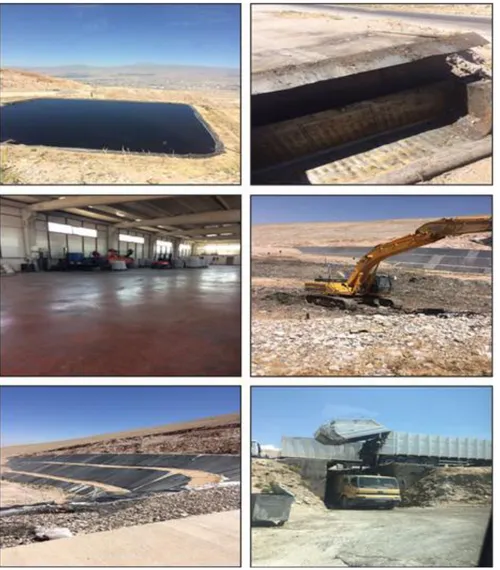
The Niğde Regular Solid Waste Storage Facility was built by Niğde Municipality. It is a 3-stage facility (Figure 2). The site selection, technical design, construction, operation, closure and post-closure control and maintenance processes of regular storage facilities are conducted with the Regulation on the Regular Storage of Wastes No. 27,533 dated March 26, 2010. Approximately 117 tons of solid waste are collected on a daily basis from businesses, houses, institutions, avenues, and streets within Niğde Municipality and adjacent municipal areas. The solid wastes generated from Niğde province are transported to the Solid Waste Regular Storage Facility in Hıdırlık region, located 7 km away from the city center, by the regular storage method (Figure 1 and 2). The Solid Waste Regular Storage Facility was completed and put into operation in 2013. 3 lots are ready to use in the facility area, and the 1st lot is currently used in the facility area.
Figure 2. Solid waste storage facility in Niğde province
In our country, the management of solid wastes is carried out in accordance with the laws and regulations. The regulations regarding the site selection of solid waste storage facilities are included in “the Regulation on the Control of Solid Wastes (Katı Atıkların KontrolüYönetmeliği)”as noted in Official Newspaper of the Republic of Turkey on March14, 1991 (T.C. Resmi Gazete, 1991).Furthermore, the general considerations to be taken into account in the selection of solid waste landfill areas have been determined by the Ministry of Environment. Accordingly, solid waste dump sites must be at least 1 km to the nearest settlement and at least 5 km to the airport. They must not be built in the protection zones of underground
and surface water where drinking water, potable and irrigation water are provided. The location of the facility established must be specified in the development plan, and it must be ensured that it is not opened for at least 40 years after it is closed to the operation. Solid waste landfill areas must never be built in regions with tectonic structure, cracks, and fractures, areas with high overflow risk, landslide and erosion sites, in the dominant wind direction, on the fault in earthquake zones, and wetlands. The situation of the surrounding traffic and transport routes and the dimension of city planning must be evaluated. Factors such as transport distance, the total storage capacity of the site, and the view of the site from the environment must be taken into account. The storage area must have the capacity to respond to needs for at least 10 years. In this study, in accordance with the aim of the study, the land use structure of the city was first examined, and the distances of usages inside and outside of the settlement area to the solid waste landfill area were determined. These distances were compared by the distances and basic criteria that should be met for solid waste landfill areas determined by the regulations and literature studies carried out.
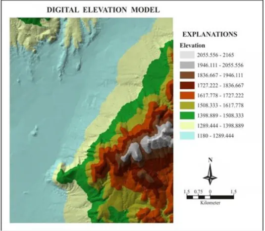
Then, the suitability of the location of the solid waste landfill area was examined using ArcGIS 10.2 softwarein the GIS within the context of the slope, visibility, and dominant wind direction analysis. The digital elevation model (DEM) representing the topography of the solid waste landfill site and its immediate surroundings was first created to perform visibility and slope analysis (Figure 3). The DEM provides a digital representation of the topographic surface expressing the formation of the hill, valley, plain, slope, coastal and water areas and settlement (Önem and Kılınçaslan, 2005; Pişkin, 2011).
Figure 3. Digital elevation model
Slope and visibility analysis was performed through the digital elevation model created. Slope analysis provides the expression of elevations according to varying slope values. Slope analysis is important in terms of the transportation of heavy tonnage vehicles to the solid waste landfill site and the prevention of
landslide, flood, and avalanche hazards. Furthermore, slope analysis is important in terms of the effects of the dominant wind direction and the effects of dust and particles to be caused by the solid waste landfill site on urban life. The effects of the dominant wind direction will also vary according to the slope of the city. In this context, the effects of the dominant wind direction were evaluated through slope analysis.
Visibility is quite important in that it may negatively affect the urban identity of solid waste landfill areas. Visibility analysis enables to perform the analysis of visible and invisible areas within the study area from one or more designated observation points (Kol and Küpçü, 2008; Bartie et al., 2008). Visibility analysis has been discussed in academic studies in different fields and areas such as national security, health, navigation, and archeology (VanHorn and Mosurinjohn, 2010; Alalouch and Aspinall, 2007; Delikostidis et al., 2013; Gümüş et al., 2017). In this study, the determination of visibility in solid waste landfill areas will contribute to the literature for the determination of environmental and visual values in solid waste landfill site selection.
Finally, the geological structure of the solid waste landfill area and its immediate surroundings was examined, and evaluation was performed according to the properties of rocks on the ground. Geologically, the presence of limited water permeability in the areas with volcanic character is the desired soil structure for solid waste landfill areas. Accordingly, the existing solid waste storage area was evaluated with the properties it has in terms of rock type, and the petrographic characteristics of rocks in the region and their suitability for structural features were discussed through geological map. The suitability of the solid waste landfill site in the city of Niğde was evaluated according to the data examined and analyses performed. RESULT AND DISCUSSION
The suitability of the existing solid waste landfill site selection in the city of Niğde in terms of the planning process of the city was evaluated according to land use status, distances to settlements specified by legislation, slope, visibility, dominant wind direction, and geological structure.
Evaluation in Terms of Land Use and Distances to Settlements Specified by Legislation
The land use structure of the city of Niğde and the distances to solid waste landfill areas were examined within the framework of legislation.
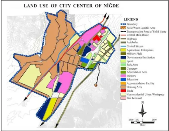
The general land use characteristics of the city of Niğde are presented in Figure 4. Accordingly, residential areas become dense in the north and northeast of the city of Niğde. Industrialization between the main route passing through the city center and the peripheral road is quite high. The solid waste landfill area is located quite outside the existing urbanization limit according to the land use map. The solid waste landfill area was evaluated in detail according to land use characteristics inside and outside the settlement.
Figure 4: Theevaluation map according to land use
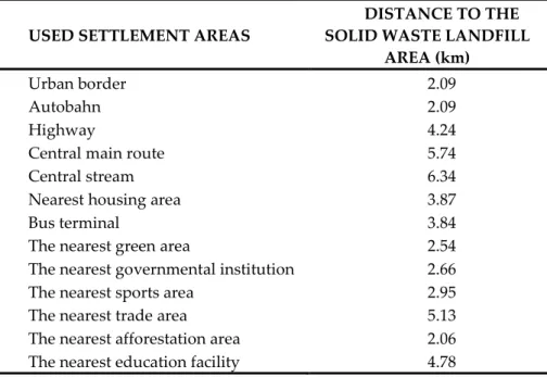
Evaluation of the solid waste landfill area according to land use characteristics inside the settlement area In Table 1, the distance of the solid waste landfill area in the city of Niğde to usages inside the settlement area was evaluated.Solid waste storage areas must be located at least one kilometer from settlement areas according to legislation. Accordingly, it can be interpreted that the location of the solid waste landfill area is suitable when the distances to the solid waste landfill area presented in Table 1 are evaluated within the scope of settlement uses (house, training facility, green area, public enterprise, trade area, afforestation areas, sports area, and bus terminal).
Table 1. The distances of existing settlement areas to the solid waste landfill area according to land use properties in Nigde province
USED SETTLEMENT AREAS
DISTANCE TO THE SOLID WASTE LANDFILL
AREA (km)
Urban border 2.09
Autobahn 2.09
Highway 4.24
Central main route 5.74
Central stream 6.34
Nearest housing area 3.87
Bus terminal 3.84
The nearest green area 2.54
The nearest governmental institution 2.66
The nearest sports area 2.95
The nearest trade area 5.13
The nearest afforestation area 2.06
The nearest education facility 4.78
The use of a bus terminal within the settlement area built on the peripheral road in recent years poses a threat to settlement area distances which are considered suitable according to today's land use characteristics presented in Figure 4. The solid waste landfill area located near the bus terminal has negative effects on the settlements for the environment where the bus terminal is located. The increase in settlements for the location where the bus terminal is located should be evaluated by future population projections, and the development of the urban area in this direction should be limited.
Evaluation of the solid waste landfill area according to land use characteristics outside the settlement area
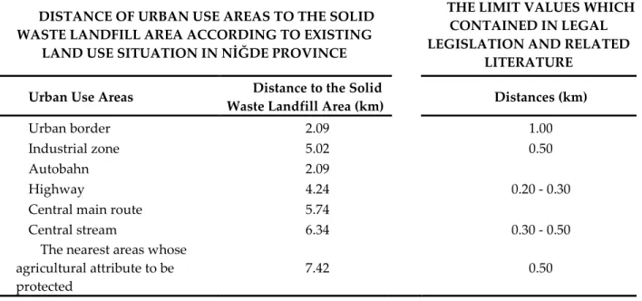
In Table 2, the distance of the solid waste landfill area in the city of Niğde to usages outside the settlement area was evaluated. According to the legislation, the distance to industrial zones and agricultural areas should be at least 500 m. The land use classes of agricultural areas, forested areas, and protected areas should be known, and these regions should be taken into consideration in site selection because, according to land use ability classes, a landfill area cannot be established in the lands of I, II, II, and IV class. The areas that can be landfill areas should not have a sandy and loamy soil texture. Apart from these, the distance of storage areas to the main transportation networks (highways-railways) should be at least 200-300 m, their distance to surface water sources and distance to drinking water supply wells should be at least 100-200 m, their distance to fault lines should be 60-80 m, and their distance to military areas and protected areas should be at least 100-500 m. The waste transport distance should be between 10 and 30 km at the most according to legislation although it varies by the size of the settlement.
Table 2. Comparison with the values in the legal legislation of existing the solid waste landfill area in Nigde province
DISTANCE OF URBAN USE AREAS TO THE SOLID WASTE LANDFILL AREA ACCORDING TO EXISTING
LAND USE SITUATION IN NİĞDE PROVINCE
THE LIMIT VALUES WHICH CONTAINED IN LEGAL LEGISLATION AND RELATED
LITERATURE
Urban Use Areas Distance to the Solid
Waste Landfill Area (km) Distances (km)
Urban border 2.09 1.00
Industrial zone 5.02 0.50
Autobahn 2.09
0.20 - 0.30
Highway 4.24
Central main route 5.74
Central stream 6.34 0.30 - 0.50
The nearest areas whose agricultural attribute to be protected
7.42 0.50
The solid waste landfill area in the city center of Niğde is situated in a location convenient to limit values in legislation in terms of its distances to the industrial zone, highway, peripheral road, and central main route. Furthermore, it can also be said that the location of the existing storage area has been selected correctly according to its distance to the central stream in the city and to the nearest areas the agricultural nature of which will be protected. As it is seen in Figure 4, the limitation of demands for settlement on the peripheral road in the future and accordingly urban development is important for protection against the negative effects of the solid waste landfill area.
Evaluation According to Slope Status
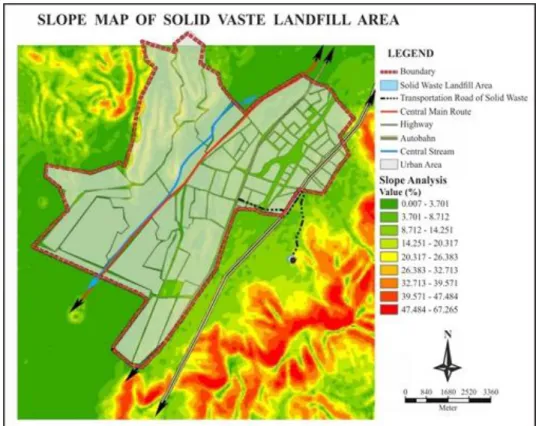
The slope can be considered as an economic factor in site selection for reasons such as accessibility for solid waste landfill areas, difficulty in the implementation of the project, and additional cost. In the study carried out by Oweis et al. (1990), it is indicated that the slope value of the areas where solid waste landfill sites are located should not be greater than 15 percent. In general, in the studies carried out, regions with a slope value of 15 percent and below and especially regions with a slope value of 7 percent and below are shown as the most suitable areas in terms of slope. Therefore, attention should be paid to the road slope while doing road planning.
Slope analysis was performed in the settlement area, solid waste landfill area, and its surroundings to analyze the slope status of the solid waste landfill site established in the city of Niğde (Figure 5).
According to the slope analysis map, the solid waste landfill area is located in the region with a slope range of 8% - 14%. Accordingly, it can be said that it is suitable in terms of land slope and the accessibility of heavy vehicles.
Figure 5. Theevaluation map according to slope status of the region Evaluation According to Visibility Status
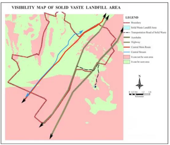
According to the Regulation on the Control of Solid Wastes, it is required that landfill areas should not be seen from the highway as much as possible. Therefore, the visibility of the existing site was analyzed (Figure 6).
As it is seen in the slope map in Figure 5, the solid waste landfill site was established in a high area. Therefore, it was determined that it was established at a dominant point where almost the whole city is visible. The solid waste landfill area is visible from certain parts of the peripheral road and highway. This situation negatively affects the inhabitants and also creates a bad urban identity for newcomers and tourists.
Figure 6. Theevaluation map according to visibility status Evaluation According to the Dominant Wind Direction
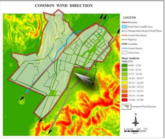
The wind or winds that mostly blow within certain periods of time in a region are called the dominant wind, and the direction they blow is called the dominant wind direction (İstanbul Üniversitesi Açık ve Uzaktan Eğitim Fakültesi, 2019).The dominant wind direction is very important in the site selection of storage facilities. Although impermeable soil is used in solid waste storage areas, they are desired not to be built open to the dominant wind direction to prevent the distribution of dust and odor by the wind. Therefore, if the storage area to be used is established without considering the dominant wind direction, unpleasant smell formed in the storage area and substances that would cause problems will be moved to settlement areas. The dominant wind direction on the city's topography is presented in Figure 7. Topography is an important factor affecting the dominant wind direction. The city is spread over an area with a lower slope compared to the solid waste landfill area. Accordingly, it can be said that the dominant wind direction may adversely affect the health of the inhabitants according to the slope of the city.
Figure 7.Theevaluation map according to common wind direction Evaluation According to the Geological Structure
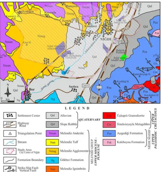
The geological features of the region are among the most important parameters used in the solid waste landfill site selection. In particular, the petrographic and structural features of the soil are very important for the protection of underground water. The presence of impermeable soil is preferred in the solid waste area. Furthermore, limited water permeability in the areas with volcanic character is the desired soil structure for solid waste storage areas. The plutonic rocks with a granular texture and the massive volcanic and metamorphic rocks are further preferred in landfill site selection for the protection of underground water. In particular, sedimentary rocks (claystone, marl) and metamorphic rocks (such as slate, phyllite, schist, and some gneisses) with high clay content have very low permeability and also the ability to absorb some amount of waste material. Therefore, these rocks can also make some purification. The regions where structural elements such as faults, cracks, and fissures are common and the areas where there are rocks with high permeability (such as abundant porous sandstone, conglomerate, basalt) are not suitable for landfill site selection. Furthermore, the bedding planes of clastic sedimentary rocks also increase permeability.
The geological map of Niğde province and its immediate surroundings is presented in Figure 8. When the geological map of the region is examined, it is observed that the solid waste storage facility is located on the Quaternary-aged slope rubble and in a region very close to the Aşıgediği formation (Figure 8). Slope rubbles are Holocene aged sediments attached loosely formed by the accumulation of block, gravel, sand and clay-sized sediments that are broken by physical and chemical decomposition from high sections on a slope. Their thickness usually varies between 1-10 m. The slope rubbles observed in the study area are 1-5 m thick. The slope rubble has a permeable characteristic since it is loosely attached. Therefore, this slope rubble
with very little thickness was removed, and the Niğdesolid waste storage facility was established on the Aşıgediği formation underneath it.
Marbles, which are the dominant lithology of the Aşıgediği formation, usually have a massive structure, mosaic and grift texture (granoblastic texture), and medium-coarse crystal characteristic. The amphibolites observed in the upper levels of this formation have a massive and nematoblastic texture while quartzites have a massive and granoblastic texture like marbles. Phyllosilicate mineral contents such as mica are high in gneisses which show massive and thick foliation structures (composition-dependent bedding) observed in the upper levels of this formation. These mica minerals were formed by the metamorphism of clay minerals. Marble, amphibolite, quartzite, and gneisses are completely crystalline, medium granular rocks. They have no pores. Therefore, all rocks forming the Aşıgediği formation have an impermeable property. In terms of structural characteristics, a large-scale fault is not observed in the region where the Niğde solid waste storage facility is located (Figure 8). On the contrary, there are some fissured structures (fractures) in the Aşıgediği formation that was affected by at least 2 deformation phases.
Figure 8. The geological map of Nigde and its surroundings (it has been received by partially modifying from Atabey (1980))
In conclusion, the region where the Niğde solid waste storage facility is located is suitable in terms of the petrographic properties of rocks on the ground and structural elements. On the contrary, it is necessary to take precautions for the fissured structures (fractures) that are observed occasionally. In particular, solid wastes stored should be prevented from being mixed in underground water by leaking from these fractures. CONCLUSION
In the century we live in, uncontrolled population growth, industrialization and therefore the increase in consumption bring along unplanned urbanization and environmental problems. The problem of solid waste and its storage is an important environmental problem that needs to be solved for the sustainable development of today's cities. The solid waste landfill area is a type of land use which is highly risky for the environment and hence community health and is important for future scenarios of a city. Therefore, where a solid waste landfill area is located is extremely important.
The aim of this study was to investigate the location of the existing solid waste landfill area located in the city center of Niğde province in Turkey according to the basic criteria selected using the GIS and to discuss the suitability of the location where it exists. According to the results obtained:
The location of the existing solid waste landfill area is within suitable distances for land uses inside and outside the city's settlement area according to legislation.
With respect to slope and geological structure, it is suitable site selection according to legislation.
According to the results obtained from visibility analysis, it has been determined that it is situated in a location that may negatively affect the urban identity of Niğde, which is already an underdeveloped city.
With respect to the dominant wind direction, it is situated in a location that may lead to negative effects on urban health.
In this study, it was determined that the proximity of the solid waste landfill area to the city boundary may constitute a problem when the direction of development and development potential of the city of Niğde on the bus terminal area and highwayduring the next 20 years are considered. The results obtained in this study carried out for the city of Niğde are quite important for future planning strategies of the city because solid waste landfill sites are high-cost areas planned to serve the city not only for today but also in the long term. Furthermore, these sites play a role in the emergence of results that will affect the direction of development, identity, and livability of the city. This study provides guidance to other studies with respect to the future of cities and increasing the success of applications for future projects of implementers by extending the scope of the criteria examined within the context of GIS.
REFERENCES
Aksoy, E., 2016.,UzaktanAlgılamaveCoğrafiBilgisistemleriKullanarak Antalya İli KatıAtıkDeponi Alanı Belirlenmesi,Master diss., AkdenizUniversity,Graduate School of Natural Sciences, Antalya, Turkey.
Alalouch, C.,Aspinall, P., 2007,“Spatial Attributes of Hospital Multi-Bed Wardsand Preferences for Privacy”, Facilities, 25, 9/10, 345–362, doi:10.1108/02632770710772450.
Arkoc, O., 2014,“Municipal Solid Waste Landfill Site Selection using Geographical İnformation Systems: a case study from Çorlu, Turkey”, Arabian Journal of Geosciences, 7, 4975-4985.
Atabey, E., 1980, 1/25.000 ÖlçekliSayısalJeolojiHaritaları, Kozan M33 a1 Paftası,TürkiyeJeolojiVeriTabanı, JeolojiEtütleriDairesiBaşkanlığı, MadenTetkikAramaGenelMüdürlüğü, Ankara, Turkey.
Baba, M.E., Kayastha, P.,Smedt, F.D., 2015,“Landfill Site Selection Using Multi-criteria Evaluation in the GIS Interface: ACase Study from the Gaza Strip, Palestine”, Arabian Journal of Geosciences, 8, 7499-7513.
Baban, S.M.J.,Flannagan. J., 1998,“Developing and Implementing GISAssisted Constraints Criteria for Planning Landfill Sites in the UK”, Planning Practice & Research, 13, 2, 139-151.
Bartie, P., Mills, S.,Kingham, S., 2008,“Geospatial Vision New Dimensions in Cartography. An Egocentric Urban Viewshed: A Method for Landmark Visibility Mapping for Pedestrian Location Based Services”, Springer, Berlin, Heidelberg, 4,61-85, ISBN: 978-3-540-709671.
Bosempem, C.,Stemn, E.,Fei-Baffoe, B.,2016,“Multi-criteria GIS-based Siting of Transfer Station for Municipal Solid Waste: The Case of Kumasi Metropolitan Area, Ghana”, Waste Management & Research, 34,10, 1054–1063.
Chang, N.B.,Parvathinathan, G., Breeden, J.B., 2008,“Combining GIS with Fuzzy MultiCriteria Decision-making for Landfill Siting in a Fast-growing Urban Region”, Journal of Environmental Management, 87,139–153.
Dağıstanoğlu, C., 2012,Eğirdir Katı AtıkDeponiAlanınınYerSeçimiKriterlerininCoğrafiBilgiSistemleri (CBS) ileBelirlenmesi,PhD diss., EgeUniversity,Graduate School of Natural Sciences, İzmir, Turkey. Delikostidis, I., Engel, J.,Retsios, B.,van Elzakker, C.P.J.M.,Kraak, M.J.,Döllner, J., 2013,“Increasing the
Usability of Pedestrian Navigation Interfacesby Means of Landmark Visibility Analysis”, The Journal of Navigation, The Royal Institute of Navigation, 66, 523–537, doi:10.1017/S0373463313000209.
Demesouka, O.E.,Vavatsikos, A.P.,Anagnostopoulos, K.P., 2016,“Using Macbeth MulticriteriaTechnique for GIS-based Landfill Suitability Analysis”, Journal of Environmental Engineering, 142, 10, 1-10. Djokanovic, S., Abolmasov, B.,Jevremovic, D., 2016,“GIS Application for Landfill Site Selection: ACase Study
in Pancevo, Serbia”, Bulletin of Engineering Geology and the Environment, 75, 1273-1299.
Donevska, K.R., Gorsevski, P.V.,Jovanovski, M.,Pesevski, I., 2012,“Regional Non-hazardous Landfill Site Selection by Integrating Fuzzy Logic, AHP and Geographic Information Systems”, Environmental Earth Sciences, 67,121–131.
Eskandari, M., Homaee, M.,Mahmodi, S., 2012,“An Integrated Multi Criteria Approach for Landfill Siting in a Conflicting Environmental, Economical and Socio-cultural Area”, Waste Management (Oxford),32,1528–1538.
Guiqin, W., Li, Q.,Guoxue, L.,Lijun. C., 2009,“Landfill Site Selection Using Spatial Information Technologies and AHP: A Case Study in Beijing, China”, Journal of Environmental Engineering, 90, 2414-2421. Gupta, R., Kewalramani, M.A.,Ralegaonkar, R.V., 2003,“Environmental Impact Analysis Using Fuzzy
Relation for Landfill Siting”, Journal of Urban Planning and Development, 129, 3, 121-139.
Gümüş, M.G., Durduran, S.S.,Bozdağ, A.,Gümüş, K., 2017,“GIS Investigation of Site Selection of Historical Structures: The Case of Knidos (Datça, Turkey)”, Mediterranean Archaeology and Archaeometry, 17,2, 149-157.
İstanbul ÜniversitesiAçıkveUzaktanEğitimFakültesi,
2019,BasıncınDağılışıveDünyaÜzerindekiDurumuileRüzgarlarınBelirginÖzellikleri,https://auzefal msstorage.blob.core.windows.net/auzefcontent/ders1/klimatoloji_basinc_ruzgar_nem/3/index.htm l, Accessed January 14, 2019.
Karadimas, N.V.,Loumos, V.G., 2008,“GIS-based Modelling for the Estimation of Municipal Solid Waste Generation and Collection”, Waste Management & Research,26, 337–346,doi: 10.1177/0734242X07081484.
Kol, Ç.,Küpçü, S., 2008, ArcGIS Spatial Analiz,İşlemCoğrafiBilgiSistemleriMühendislikveEğitim Ltd. Şti., Ankara, Turkey.
Kolay, U.E., 2012,Altertanif Katı AtıkDeponiAlanlarınınYerSeçimindeCoğrafiBilgisistemiTabanlıÖrnekBirUygulama, Master diss., BahçeşehirUniversity,Graduate School of Natural Sciences, İstanbul, Turkey.
Kontos, T.D.,Komilis, D.P.,Halvadakis, C.P., 2005,“Siting MSW Landfills with a Spatial Multiple Criteria Analysis Methodology”, Waste Management, 25, 818-832.
Lokhande, T.I.,Mane, S.J., Mali, S.T.,2017,“Landfill Site Selection Using GIS and MCDA Methods:A Review”,International Journal of Research in Engineering, Science and Technologies (IJRESTs), 3, 3, ISSN 2395- 6453.
Maguiri, A.E., Kissi, B.,Idrissi, L.,Souabi, S., 2016,“Landfill Site Selection Using GIS, Remote Sensing and MulticriteriaDecision Analysis: Case of the City of Mohammedia, Morocco”, Bulletin of Engineering Geology and the Environment, 75, 1301-1309.
Mahini, A.S.,Gholamalifard, M., 2006,“Siting MSW Landfills with a Weighted Linear Combination Methodology in a GIS Environment”,International Journal of Environmental Science and Technology, 3, 4, 435-445.
Moeinaddini, M.,Khorasani, N.,Danehkar, A.,Darvishsefat, A.A.,Zienalyan, M., 2010,“Siting MSW Landfill Using Weighted Linear Combination and Analytical Hierarchy Process (AHP) Methodologyin GIS Environment (Case Study: Karaj)”, Waste Management (Oxford), 30,912–920.
Monsef, H.A., 2015,“Optimization of Municipal Landfill Siting in the Red Sea Coastal Desert Using Geographic Information System, Remote Sensing and an Analytical Hierarchy Process”, Environmental Earth Sciences, 74, 2283-2296.
Oweis, I., Smith, D.A., Ellwood, R.B.,Greene. D.S., 1990,“Hydraulic Characteristics ofMunicipal Refuse”, Journal of Geotechnical Engineering, 116,4,doi:10.1061/(ASCE)0733-9410(1990).
Önem, A.B.,Kılınçaslan, İ., 2005,“Urban identity and environmental perception in Haliç.” İstanbul TeknikÜniversitesiDergisi/a:Mimarlık, PlanlamaveTasarım, 4, 1, 115-125.
Pişkin, G., 2011, Spatial Analysis of Archaeological Settlements in Aliağa and Its Surroundings Using GIS, Master diss.,Ege University, Graduate School of Social Sciences, İzmir, Turkey.
Randazzo, L., Cusumano, A.,Oliveri, G.,Stefano, P.D.,Renda, P.,Perricone, M.,Zarcone, G., 2018,“Landfıll Site Selection for Municipal Solid Waste by Using AHP Method in GIS Environment: Waste Management Decision-Support in Sicily (Italy)”,Detritus, Multidisciplinary Journal for Waste Resources & Residues,2, 78-88,doi: 10.31025/2611-4135/2018.13656.
Rathore, S., Ahmad, S.R.,Shirazi, S.A., 2015,“Application of GIS Based Model in Landfıll Site Selection: ACase Study of Lahore, Pakistan”, Pakistan Journal of Science, 67, 4, 359-364.
Sekulovic, D.,Jakovljevic, G., 2016,“Landfill Site Selection Using GIS Technology and the Analytic Hierarchy Process”, Earth Sciences, 64, 3, 769-783,doi: 10.5937/vojtehg64-9578.
Sumathi, V.R., Natesan, U., Sarkar, C., 2008,“GIS-based Approach for Optimized Siting of Municipal Solid Waste Landfill”, Waste Management (Oxford), 28,2146–2160.
Şener, B., Süzen, M.L.,Doyuran, V., 2006,“Landfill Site Selection by Using Geographic Information Systems”, Environmental Geology, 49, 376–388.
Şener, Ş., Sener, E.,Karagüzel, R., 2011,“Solid Waste Disposal Site Selection with GIS and AHP Methodology: ACase Study in Senirkent–Uluborlu (Isparta) Basin, Turkey”, Environmental Monitoring and Assessment, 173, 533-554.
T.C. ResmiGazete, 1991, Katı AtıklarınKontrolüYönetmeliği, 20814, March 14, 1991, http://www.resmigazete.gov.tr/arsiv/20814.pdf, Accessed December 12, 2018.
Uyan, M., 2014,“MSW Landfill Site Selection by Combining AHP with GIS for Konya, Turkey”, Environmental Earth Sciences, 71,1629–1639,doi: 10.1007/s12665-013-2567-9.
VanHorn, J.E.,Mosurinjohn, N.A., 2010,“Urban 3D GIS Modeling of Terrorism Sniper Hazards” Social Science Computer Review, 28,4, 482–496, doi:10.1177/ 0894439309360836.
Varınca, K.B., Esmen, C.,Gönüllü, M.T., 2009,“Bursa İli TıbbiAtıkYönetimSistemiPerformansDeğerlendirmesi”,Türkiye’de Katı AtıkYönetimiSempozyumu, İstanbul, 1-4, 15-17 Haziran 2009.
Yıldırım, V., 2012,“Application of Raster-Based GIS Techniques in the Siting of Landfills in Trabzon Province, Turkey: A Case Study”,Waste Management &Research, 30, 9, 949-960.