(MASTER THESIS)
ANALYSIS OF WAYFINDING STRATEGIES AND
COGNITIVE MAPPING DIFFERENCES: CASE
STUDY OF AEGEAN UNIVERSITY POLYCLINICS
Zeynep SEVİNÇ
Thesis Advisor: Assist. Prof. Dr. Eray BOZKURT
Department of Interior Architecture
Bornova – İZMİR 2013
YASAR UNIVERSITY GRADUATE SCHOOL OF NATURAL AND APPLIED SCIENCES
ANALYSIS OF WAYFINDING STRATEGIES AND
COGNITIVE MAPPING DIFFERENCES: CASE
STUDY OF AEGEAN UNIVERSITY POLYCLINICS
Zeynep SEVİNÇ
Thesis Advisor: Assist. Prof. Dr. Eray BOZKURT
Department of Interior Architecture
Bornova – İZMİR 2013
This study titled “Analysis of Wayfinding Strategies And Cognitive Mapping Differences: Case Study Of Aegean University Polyclinics” and presented as Master Thesis by Zeynep SEVİNÇ has been evaluated in compliance with the relevant provisions of Y.U. Graduate Education and Training Regulation and Y.U. Institute of Science Education and Training Direction and jury members written below have decided for the defense of this thesis and it has been declared by consensus / majority of votes that the candidate has succeeded in thesis defense examination dated 28.03.2013.
Jury Members: Signature:
Head : Assist. Prof. Dr. Eray BOZKURT .………...
Rapporteur Member :.Prof.Dr. Tayfun TANER ………
I hereby certify with honor that this MSc/Ph.D. thesis titled “ANALYSIS OF WAYFINDING STRATEGIES AND COGNITIVE MAPPING
DIFFERENCES: CASE STUDY OF AEGEAN UNIVERSITY”was written by me, without aid that would not comply with scientific ethics and academic traditions, that the bibliography I have used is that indicated in this thesis and that appropriate reference has been given whenever necessary.
28/03/2013
ÖZET
YÖN BULMA STRATEJİLERİ VE BİLİŞSEL HARİTALANDIRMA FARKLILIKLARI: EGE UNİVERSİTESİ HASTANESİ
POLİKLİNLİKLERİ VAKA ÇALIŞMASI
SEVİNÇ, Zeynep
Yüksek Lisans Tezi, İç Mimarlık Bölümü Tez Danışmanı: Yard. Doc. Dr. Eray BOZKURT
Mart 2013, 103 sayfa
İnsanlar içine girdikleri binalarda yönlendirilmeye ihtiyaç duyarlar. Yönlendirme sürecinde bir yol seçmek veya rotaya karar vermek zorundadırlar. Bu süreci kolaylaştırmak için alanın zihinsel veya bilişsel bir haritasına ihtiyaç duyulur. Bilişsel Haritalama oluşturmak için binanın tasarımından sorumlu kişinin, farklı tasarım stratejileri geliştirerek planlama aşamasında bu duruma müdahale etmesi gerekmektedir.
Günümüze kadar tasarlanan sağlık binalarında, mimari tasarım yaklaşımları büyük değişikliklere uğramaktadır. Geçmişte yaşanan tecrübeler ve uzmanların görüşleri doğrultusunda iç mekân tasarımının önemi farklı kaynaklarda vurgulanmaktadır. Özellikle “Yön Bulma Stratejileri” ve “ Bilişsel Haritalama Sistemi” oluşturulmamış hastanelerde hastalar ve/veya ziyaretçiler bir hedefe ulaşmak için güzergâh boyunca bazı zorluklar yaşayabilirler.
Algıdaki farklı seçicilikten dolayı insanların mekânı ve alt mekânları farklı algılamasında yaşın ve cinsiyetin etkisi bulunmaktadır. Bu veriler doğrultusunda yön bulma sorunları dikkate alınarak, etkili yön bulma elemanlarının kullanımı ve insan ile mekânsal biliş bulma yolu Ege Üniversitesi Poliklinikleri vaka çalışması olarak incelenmiştir.
Anahtar Kelimeler: Yön bulma stratejileri, Bilişsel haritalama,
ABSTRACT
ANALYSIS OF WAYFINDING STRATEGIES AND COGNITIVE MAPPING DIFFERENCES: CASE STUDY OF AEGEAN UNIVERSITY
POLYCLINICS
SEVİNÇ, Zeynep
M.Sc. in Interior Architecture
Supervisor: Assist. Prof. Dr. Eray BOZKURT March 2013, 103 pages
When people enter a building, they expect to see wayfinding elements, during wayfinding period, they need a guidance to decide which path or route to follow at next stage. To ease this wayfinding period, cognitive or mental map of the space will provide valuable information. During the design stage, the building’s designer can improve the cognitive map of the context by developing necessary design strategies.
Since today’s architectural design of the healthcare buildings has undergone vast amount of changes, past experiences indicate that interior design is the most crucial factor in the hospital setting. Especially, the hospitals in which no “Wayfinding Strategies” and “Cognitive Mapping System” are set off may cause the patients and/or visitors to experience some difficulties while deciding the route to reach a target location.
Due to different selective of perceptions, people differ in cognition of place and sub places with an impact of age and gender. Wayfinding failures in the building enhance navigational breakdowns. For this purpose, considering the way finding problems, usage of affective wayfinding elements and human spatial cognition is studied within the case study of Aegean University Polyclinics.
Keywords: Wayfinding strategies, Cognitive mapping, Healthcare
ACKNOWLEDGEMENTS
First of all, I wish to express my deepest gratitude to Assist. Prof. Dr. Eray BOZKURT the supervisor of this thesis, for his kind guidance, criticism and encouragement throughout the work.
Very special thanks to Buse PARLAR, Selcan DÖKMEN, Pınar SEZGİNALP, Sırma ÖZÜDOĞRU, Miray ÖKTEM and Seda ŞAHİN for their kind help.
I am also thankfull to Assist. Prof. Dr. Şükrü Mert KARCI for his help and criticism during questionnaire survey and for his comments and motivation during the preparation of this thesis.
My Acknowledgement should also be extended to the kinds of Izmir University’s Instructors of Architecture Department; Assist. Prof. Dr. Özgü ÖZKAN, and Assist. Prof. Dr. Özlem TAŞKIN ERTEN for their kind guidance and helps for my thesis.
Last, but not least, I would like to express my deepest gratitude to my parents Dr. Erdal & Dr. Çiğdem SEVİNÇ and to my brother Assist. Prof. Dr. Akın SEVİNÇ for their support in every aspect of my life. This thesis would have not been possible without your support.
TABLE OF CONTENTS Page ÖZET..……….v ABSTRACT..………..vi ACKNOWLEDGEMENTS ………….……….vii TABLE OF CONTENTS………..…viii
INDEX OF FIGURES ……….xiv
ABBREVIATIONS………..xxi
CHAPTER I - CONCEPTUAL FRAMEWORK ………..………...….. 1
1.Introduction ………...1
CHAPTER 2 – HEALTHCARE DESIGN ………..………...6
2.1. Healthcare Design Criteria………....…….…………...7
2.1.1. Type of the Hospital ……..………..………..7
2.1.2. Shape of the Building….……...………..……….………..9
2.1.3. Location……….……...………..……….………...9
2.1.4. Material Selection…...….……...………..……….………..10
TABLE OF CONTENTS (cont.)
Page
2.2. Healthcare Design in Turkey ………..……….………..12
2.2. Healthcare Wayfinding……. ………..……….………..13
CHAPTER 3 – ANALYSIS OF WAYFINDING BEHAVIOR AND COGNITIVE MAPPING ………..……….16
3.1. Wayfinding Behavior………....…….………….……16
3.1.1. Definition of Wayfinding …..………....…….………….……16
3.1.2. Different Approaches to Wayfinding …..…..……....…….………….……19
3.1.3 Stages of Wayfinding …..…..……....………..………….……24
3.1.3.1. Orientation………...…..…..……....………..………….…...…25
3.1.3.2. Route Decision ………...………....……….………….……25
3.1.3.3. Route Monitoring….…...………....………..………….…...…26
3.1.3.4. Destination Recognition………....………...…….……26
3.1.4. International Wayfinding Examples...………..………….……27
3.1.4.1. Transport – SNCF - France Railway Station (Digital Screen, Banner, Sign)……….………..…27
3.1.4.2. Healthcare – Palo Alto Medical Foundation Camino Medical Group (Pictograms, Tactile Boards, YAH Maps)………...…..29
TABLE OF CONTENTS (cont.)
Page
3.1.4.3. Commercial – Maxi Joy Shopping (Color Coding, Banners)…….…….30
3.1.4.4. Culture – Castles, Palaces and Antiquities in Rhineland – Palatine (Flag, wall mounted Banners, Signages) ………33
3.1.4.5. Education – Universities’ Wayfinding Hub (Signage, YAH Map, Pictogram)………..…………..………..36
3.1.4.6. Office – Dow Chemical Company, Houston Office (Color Coding, Banners, Signage)……….……….38
3.1.5. Elements of Way Finding………...40
3.2. Cognitive Mapping………..48
3.2.1. Definition of Cognitive Mapping………...…………..49
3.2.2. Cognitive Mapping Strategies………...…………...50
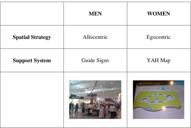
3.2.2.1. Allocentric Mapping Strategy……….………..52
3.2.2.2. Egocentric Mapping Strategy………53
CHAPTER 4 – A CASE STUDY OF AEGEAN UNIVERSITY POLYCLINICS BUILDING………55
4.1. Observations on Aegean University Hospital Polyclinics…………...……...55
TABLE OF CONTENTS (cont.)
Page
4.1.1.1. Location of Polyclinics in the Building………...….56
4.1.1.2. Density of Polyclinics in the Building………...………...57
4.1.2. Elements of The A.U. Building………...……….62
4.1.2.1. Entrance………...……..63
4.1.2.2. Information Areas……….65
4.1.2.3. Corridors………...66
4.1.2.4. Waiting Areas………68
4.1.3. Wayfinding Elements in Aegean University Polyclinics Building…...…...71
4.1.4. Changes In Last Six Month………...………...74
4.2. SURVEY……….79 4.2.1. Method……….79 4.2.2. Participant………79 4.2.3 Aim………82 4.2.4.Results………...85 CHAPTER 5 - CONCLUSIONS ………101
TABLE OF CONTENTS (cont.)
Page
BIBLIOGRAPHY ………103
CURRICULUM VITAE ………..109
APPENDICES
Appendix A Interview with Prof. Dr. Mehmet Nuri Tureyen
Appendix B Distribution of Hospitals by Provinces in Turkey 2000-2010
Appendix C Number of Beds in Public and Private Inpatient Institutions 1967-2010
Appendix D Survey Both in English and Turkish
INDEX OF FIGURES
Figure Page
Figure 1.1. Thesis flow……….…2
Figure 2.1. Types of hospitals………..8
Figure 2.2. Floor covering types of hospitals……….10
Figure 2.3. Corridor with perpendicular lighting on walls………...……...….…..14
Figure 3.1. Path example: Kordonboyu, Izmir………..…….20
Figure 3.2. Kevin Lynch’s path sketch………..20
Figure 3.3. Kevin Lynch’s node sketch……….21
Figure 3.4. District example: Balcova, Izmir………...………..21
Figure 3.5. Kevin Lynch’s district sketch………..22
Figure 3.6. Node example: Gündoğdu Meydanı, Izmir……….22
Figure 3.7. Kevin Lynch’s node sketch……….22
Figure 3.8. Landmark example: Clock Tower, Izmir……….…23
Figure 3.9. Kevin Lynch’s landmark sketch………..23
Figure 3.10. Orientation example: San Antonio, TX …...……...………25
Figure 3.11. Route decision example: Evacuation Plan Template………26
INDEX OF FIGURES (cont.)
Figure Page
Figure 3.13. Poster frames, France……….28
Figure.3.14. Pictograms for multi-lingual audience………..………….29
Figure 3.15. Tactile directories………..29
Figure 3.16. Views from Maxi Joy shopping center………..………31
Figure 3.17. Flags and banners………..34
Figure 3.18. Signage design………...34
Figure 3.19. Wayfinding elements…………...……….…….35
Figure 3.20. Universities’ wayfinding hub……….……….…..36
Figure 3.21. Signage design for hubs………...………..……37
Figure 3.22. Entrance and reception area of DOW………...………...39
Figure 3.23. Photographic images on corridors………....…….39
Figure 3.24. Vertical and horizontal banners………..……...………..…..40
Figure 3.25. Wall-mounted sign……….44
Figure 3.26. Ceiling-mounted sign……….………44
INDEX OF FIGURES (cont.)
Figure Page
Figure 3.28. Flag-mounted sign……….………44
Figure 3.29. YAH maps, Agora mall, Optimum mall, Izmir ………45
Figure 3.30. Tactile door number………...46
Figure 3.31. Color-coding, Agora mall, Izmir………...46
Figure 3.32. Rapoport’s cognitive perception evaluation scheme……….49
Figure 3.33. Results of experiments by Chen, Chang and Wen-Te Chang ……..54
Figure 4.1. Relationships between the main building and other polyclinics…….57
Figure 4.2. Aegean University patient density by months - 2011……….58
Figure 4.3. Aegean University patient density by months - 2011, Data from figure 4.2. are graphically shown……….58
Figure 4.4. Patient number per 1 day of each polyclinic………..……….59
Figure 4.5. Patient number per 1 day of each polyclinic. Data From Figure 4.4 graphically shown………..60
Figure 4.6. Density of polyclinics shown with colors……..……….61
Figure 4.7. Experienced zones………...62
INDEX OF FIGURES (cont.)
Figure Page
Figure 4.9. (a) Monumental gateway of A.U. ……..………64
Figure 4.9. (b) Traffic circle node….…………...………..64
Figure 4.9. (c) Road to polyclinics………..………..64
Figure 4.9. (d) Road to polyclinics………..………..64
Figure 4.10. Locations of information areas.……….…65
Figure 4.11. (a) Information area1………66
Figure 4.11. (b) Information area 2.………...66
Figure 4.12. Corridors of A.U. polyclinics ………...……67
Figure 4.13. Node points of A.U. polyclinics………...………....68
Figure 4.14. Waiting areas of A.U. polyclinics……….69
Figure 4.15. (a) Inner waiting area ………...70
Figure 4.15. (b) Main waiting area………70
Figure 4.16. Waiting seats around inner courtyard………70
Figure 4.17. Banners with signage…..………..71
INDEX OF FIGURES (cont.)
Figure Page
Figure 4.19. Digital screen……….73
Figure 4.20. Information desk in A.U………74
Figure 4.21. New information desk………75
Figure 4.22. (a) New location of information desk 1.………...….75
Figure 4.22. (b) Previous location of information desk 1……….76
Figure 4.23. (a) Previous inner garden………...76
Figure 4.23. (b) During removal………77
Figure 4.23. (c) After removal………...77
Figure 4.24. New YAH map………..…78
Figure 4.25. Survey area, entrance, information area, and inner garden……...…80
Figure 4.26. Option 1; Paths to the waiting areas………..81
Figure 4.27. Option 2; Paths to the waiting areas………..82
Figure 4.28. “Question2: Which wayfinding element would you prefer for navigating in a building?”……….….83
Figure 4.29. Sketch layout……….84
INDEX OF FIGURES (cont.)
Figure Page
Figure 4.31. Age frequency of participants with pie chart………86
Figure 4.32. Percentages of age groups……….86
Figure 4.33. Education level of participants with pie chart………...87
Figure 4.34. Percentages of age groups……….87
Figure 4.35. Percentages of age groups with pie chart………..88
Figure 4.36. Results of question 1………..89
Figure 4.37. (a) Gender comparison of question 2……….89
Figure 4.37. (b) Age comparison of question 2……….90
Figure 4.38. (a) Gender comparison of question 3……….91
Figure 4.38. (b) Age comparison of question 3……….91
Figure 4.39. “Results from sketches; does the participant show any zones?”…..92
Figure 4.40. (a) Gender comparison of latent learning………..93
Figure 4.40. (b) Age comparison of latent learning………...93
Figure 4.41. Sketches of some women participants showing zones………..94
INDEX OF FIGURES (cont.)
Figure Page
Figure 4.43. Age comparison of route description……….96
Figure 4.44. Sketches of some women participants showing their route………...97
Figure 4.45. Sketches of some men participants showing their route………97
Figure 4.46. (a) Gender comparison of accuracy of sketches………98
Figure 4.46. (b) Age comparison of accuracy of sketches……….98
Figure 4.47. (a) Female sketches………99
TABLE OF ABBREVEATION
Page
A.U.: Aegean University
E.R.: Examination Room
IAQ: Indoor Air Quality
VOC: Volatile Organic Compounds
SNCF: (Société Nationale des Chemins de fer français), French National Railway Corporation
UNESCO: United Nations Educational, Scientific and Cultural Organization
YAH Map: You Are Here Map
B.C.W.: Blue Collar Worker
CHAPTER 1 - CONCEPTUAL FRAMEWORK
This first chapter tries to put the research topic in its setting of the wayfinding behavior and its relation with cognition. This preliminary chapter also introduces the basic research subject, goals, objectives and limitations of the study, as well as its research methods and its scope.
1. Introduction
In today’s healthcare design, functionality and aesthetic became more important both for, patients, personnel and for the owner of the institution. One of the concerns that healthcare designers have to overcome is circulation flow. To cope with wayfinding problems they should be informed about importance of wayfinding, its elements and cognitive mapping differences between users.
Wayfinding task and cognitive mapping process are a phenomenal consciousness both emphasizing the skills that have to be developed with and without the aid of assistive technology. Besides the technical differences, cultural, regional, educational and gender differences affect people’s perception of space.
Anyone experiencing feeling of disorientation or momentarily being lost occurs because of a wayfinding failure. This failure maybe occurred due to different circumstances (Golledge, 1999). Individuals differ in how they navigate in an environment. People may report a good sense of direction or poor sense of direction according to environment.
In 1990’s regardless of the function and type of the building wayfinding systems were just using simple sign systems. Today, with technological improvements that come with globalization, wayfinding systems became a required criteria. Getting people from one location to another location is becoming more complicated; transportation options are increasing due to improved technology. Importance of wayfinding activities increases in the process of time.
Exploration is a fundamental task to human existence, for thousands of years, humankind needed to be directed to somewhere that they needed to go whether it was a cave, a hole or somewhere safe. This study was conducted to explore wayfinding strategies in indoor healthcare environment and their relationsto the user’s knowledge. A person’s perception of space, and legibility of the space are results of cognitive maps (Lynch, 1960). Cognitive mapping is perceiving and storing data from experiences, people orient themselves with creating visual mental maps of the environment. While navigating in a building we need to be directed and make some decisions during our route to destination point. Cognition of the space helps for wayfinding.
The aim of this thesis is research relations between wayfinding skills and cognitive mapping styles, to examine the role of cognitive maps in human wayfinding activities that take place in a healthcare environment, especially, to analyze the conditions in obstructed or unobstructed environments. When these fields are deeply investigated pioneers of visual perception; Kevin Lynch’s and Romedi Passini’s studies are examined in this thesis.
The thesis has a goal to investigate the definition of wayfinding, polyclinic of cognitive mapping, wayfinding elements and identify the important components for cognitive mapping. The solutions were discovered with the chosen case study; Aegean Hospital Polyclinics. (Figure 1.1)
Figure 1.1. Thesis flow
Cognitive Mapping
Wayfinding Elements
Visual Perception
Experienced zones
Pe rf or m ance E va lu at io n Ca se S tu dy : A . U .H os pit al RESULTS Hos pit al’ s W ayf indi ngINDICATORS
In the first part of the thesis, aim of the thesis is explained by giving description of the study. Following introduction, chapter 2 discusses healthcare design approaches; type, shape of the hospital, location, material selection, HVAC, healthcare design and healthcare wayfinding elements.
Chapter 3 introduces analysis of wayfinding behavior and cognitive mapping; they are explained with introducing meanings and examples. This part includes definitions, and stages of wayfinding, international wayfinding examples (Healthcare, Commercial, Museum, Education, Culture) and cognitive mapping strategies; allocentric and egocentric are described as well. Also differences between different age groups and genders are also stated in this chapter.
After informing about wayfinding and cognitive mapping subjects chapter 4 analyses A.U. building and its users according to the criteria explained in chapter 3. Chapter 4 is case study of A.U. polyclinics building, this chapter consists of 2 parts, part one is observations of the building and part two is survey study. Part one starts with observations like current conditions; location and density, also in part one zones in the building: entrance, information areas, corridors, waiting areas was detailed in the architectural analyses of the study. Part two is survey study, aim, method, participants and results of the survey are explained. Survey results obtained from A.U. patients are graphical represented, and the discussions of these results along with decisions are stated in part two.
In order to authenticate the purpose of the study, books and previous theses on wayfinding, cognitive mapping, regulations on healthcare design are studied. Also technical drawings, hospital plans, photographs, websites have been used during study.
The thesis is developed over three research approaches; (1) research on past literature review, (2) on site field survey, and (3) structured interview with Prof. Dr. Mehmet N. TÜREYEN. First approach concentrated on the definition of wayfinding, its origins, stages, elements, problems and decisions. Different circulation paths of different users’ connections between buildings and
chronological additions are shown. Historical evolution and differences between the additional and pre-existing buildings are stated. How the connections and circulation are controlled, what design strategies are used, orientation, space analyze topics are mentioned. In the end, design elements, and methods are discussed and explained with examples.
In the second approach, Izmir Aegean University’s polyclinics’ were taken into the scope of the research. Quantitative data should be taken in to consideration; a research survey was given to first-time and second-time users for analyzing wayfinding and cognitive mapping differences.
Field survey is formulated mainly to determine wayfinding problems in A.U. polyclinics building. Intercept survey was conducted; this is indeed a type of survey in which the present users took full part. The survey was conducted ın the main waiting area to 40 participants (20 male and 20 female) who responded the call favorably. Results of the survey were evaluated according to age and gender differences. Considering the scarcity of resources, results were found to be satisfactory, as the survey was conceived basically as a study for tentative results.
The final approach includes a structured interview with Prof. Dr. Mehmet Nuri TUREYEN, who had designed a new building for A.U. polyclinics in 1987, his building was specifically designed for polyclinics purpose. That building had never been used for that function. The aim of that interview was to determine whether, any design strategies for wayfinding were considered or not. Even though the specialized building was erected, management of the Aegean University kept using the existing insufficient building.
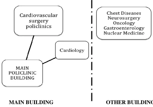
The main entrance of the polyclinics of Aegean hospital is off-centered, after passing through the vestibule you need to choose your route for your destination; however, the main problem occurs at this point, your desired polyclinic destination might not be in the main polyclinics building. Even though there is a “Policlininc” sign on the outside of the building, for instance if you need to go to “Neurology Department” you have to travel around the main polyclinics
building and find the entrance of another additional building for Neurology Department. There are no direct connections between the additional building and the main building.
From 1955 to 1987 there was only one building for all polyclinics and it was meeting the requirements. Due to increasing number of the staff, departments and patients, there was a need of a new building. As a result of this deficiency, TUREYEN’s building could be used to meet this requirement. However his buildins had never been in use for polyclinic function. Today, it is the dean building. (Appendix A). Today all polyclinics are located in different buildings, main building is not sufficient to include all polyclinics under the same roof.
In the thesis healthcare buildings especially hospitals are discussed, excluding private hospitals, large or small health care centers, nursing homes and special clinics. Wayfinding elements including, signs, banner, you are here (YAH) maps, tactile boards, and color-coding method are analyzed. Different cognitive mapping strategies, between allocentric and Egocentric mapping styles are discussed. While analyzing the building changes on wayfinding elements in the A.U. polyclinic building till October 2012 analyzed.
CHAPTER 2 – HEALTHCARE DESIGN
Since the human being existed health problems have occurred, due to that, places for patients were required. During medieval ages temples were in use both for religious service and healing places for patients. Religious beliefs were taken apart for treatment hence; first hospitals had been built by churches where monks and nuns were keeping the maintenance (Uzunay, 2011).
According to vast changes in medical world and technology, design of hospitals has changed up-to-today. Plan of a hospital needs to be easy to understand. Considering the fact that people generally visit hospitals for a variety of reasons, design needs to reduce stress, as feeling safe is very important, first impression in hospitals reduces patients’ stress (Ergenoglu, 2006).
Healthcare architecture differs from other type of buildings; functional relations between different departments in the complex make the design more complicated for the architect and the supporting team. Applying design tools and methods within the hospital context need a specialized proficiency. While designing the hospital architect should be a talented problem solver, know new medical treatments & procedures, and should be familiar with existing equipment and diseases. Hospitals are complex structures, while designing; function, order, aesthetic and hygiene are important criteria. Today health care buildings are more modern and elaborated as hotels. Design should meet the requirements of patients, patients’ families and visitor. To satisfy these needs, the efficient design of healthcare building becomes considerably important. Collaboration with unqualified professionals and lack of communication between the organizer, designer and the user results in wrong applications.
According to Uzunay (2011) there are some phases for designing hospitals. As a result of overcoming these phases, resulting product would be more functional and useful. The phases are; Planning Decisions, Programming, Designing, Application and Use.
Decision Planning: This process includes evaluation and investigation
requirements of the site.
Programming: This process programs the number of beds, capacity of
departments according to legislations and regulations.
Designing: Designing the building according to the data which is obtained
by designers.
Application: Building construction phase.
Use: Using the building after the whole process pattern.
2.1. Healthcare Design Criteria
While designing a hospital there are some factors affecting the design these are, type of the hospital, shape of the building, location, material selection and HVAC.
2.1.1. Type of the Hospital
Hospitals are intensely complex buildings, this affects the design, and while designing a hospital function, aesthetic, and hygiene should be taken in to consideration, besides these, type of the hospital affects the design. Even if it is a State hospital, Private hospital, District hospital, Mental hospital, Maternity hospital, Children hospital, or Specialized (eye, psychology…) hospital, design differs according to the service provided by. (Figure 2.1)
Figure 2.1. Types of hospitals (Source: Türkiye Sağlık Yapıları Asgari Tasarım Standartları 2010 Yılı Kılavuzu)
Same design cannot be applied to two different types of hospitals. Hospitals are classified according to the given service. Firstly, they are divided in to two main categories: Training and Research hospital and Service hospital. After this classification service hospitals are divided in to three: specialized, Psychiatric and general hospitals. Specialized hospitals are also divided in to three; Maternity, Eye and Physical Therapy and Rehabilitation Hospitals.
For instance design of a children hospital and mental hospital should be different form each other. Each field of study has its own requirements that determine the planning. Each type has its own procedure and design criteria (Türkiye Sağlık Yapıları Asgari Tasarım Standartları 2010 Yılı Kılavuzu, 2010).
2.1.2. Shape of the Building
Another criterion that affects the flow of patients in a building is the type of the building, the plan scheme. In Turkey during 1940’s “T”, “U”, “L” plan layouts were practiced. In these plan types polyclinics, laboratories, diagnosis departments and x-ray departments were located at the first floor, and patient care units were at the second floor. Shapes of the windows were square or rectangular. Due to population increase in 1960’s plan types of hospitals started to change, number of polyclinics started to rise, footprint of the treatment units enlarged. For this reason small hospitals yield to larger ones. In 1980’s instead of vertical structure, horizontal expansion structure began. Starting with the beginning of 1990, number of private hospitals started to increase (Uzunay, 2011).
2.1.3. Location
Before designing a healthcare building location of land is outmost important. According to the earthquake region land information system, investigation on seismic map of the land geological data should be achieved. Since healthcare buildings are heavy-duty public facilities good planned vehicle entrance and exit is necessary. According to Turkiye Saglık Yapıları Asgari Tasarım Standartları 2010 Yılı Kılavuzu regulations, there are some criteria for hospital locations:
Pollution free areas (noise, air and water) Reachable via pubic transportation
Far away from non-healthy, industrial institutions Less traffic density
Enough parking place
Planned electric, gas, water, drainage infrastructure systems Close to other healthcare places
Also, the building should not serve for another function due to sterilization concerns. In the hospital, complex public houses should be available for doctors,
nurses and for technical stuff, if possible a hotel for patients from outside of the city can be located.
2.1.4. Material Selection
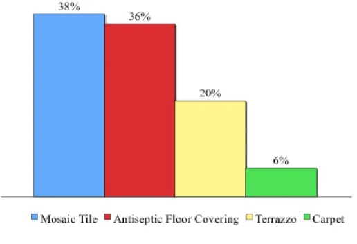
Healthcare design needs more than merely standard interior finishing and space organization. Until, recently material selection was always been an overlooked factor for interior design of a healthcare facility. During the design of a healthcare facility architects make decisions over the selection of materials for interior design. Material of the walls, floors, ceilings, finishings, furnitures, isolation materials and equipments should be selected due to some parameters. Certified contractors aware of infection and maintenance concerns are required during the design process (Cook, et al., 2008). Figure 2.2 shows commonly used floor-covering materials in health care facilities.
Figure 2.2. Floor covering types of hospitals (Filiz Şenkal, 2001)
Floor covering material has the largest area in the building, it should be aesthetic, available and affordable.
Finishing materials for different interior spaces can be different from each other. For instance material for the lobby and examination room should be different, for lobby primary criteria is hygiene and durability of the material, but in E.R., finishing material should be seamless and easily cleanable, when parameters change optimum material changes too. Wet areas like, surgery rooms, toilets and laundry rooms should be ceramic tile.
Using non-combustible materials and suitable material is also important for hospital design. Materials emit Volatile Organic Compounds (VOCs) create unhealthy environments in healthcare facilities (Cook et al., 2008). While selecting the materials, VOCs parameter is also utmost important to create a healthy environment for medical patients and staff.
2.1.4. HVAC
Hospital environment is not easy to keep sterile; spread of diseases and infections is a significant concern among professionals. There are several reasons contributing unhealthy environments. Architects and designers are aware of the importance of protecting the patients and employees from the unhealthy breathing air.
There are several factors that decrease indoor air quality (IAQ) these are primarily; mold, bacteria, combustion pollutants and off gassing that emits VOCs.
Environmental Protection Agency has issued that IAQ is one of the most important health problems in healthcare buildings. Carpet, paint, varnishes, floorings, insulations, adhesives, green materials, ventilation systems and particleboard are products that affect IAQ. While designing a health care building considering the facts that affect HVAC and IAQ should be taken in to consideration (Cook, et al., 2008).
2.2. Health Care Design In Turkey
During prehistoric periods, medicine was attached with nerve and spiritual feelings, Turks did not have a specialized health agency. The oldest known studies belong to Sumerians, they were using spiritual emotions for healing; they did not have the concept of a hospital. Whether Turkish hospital architecture structure examined, it can be classified in to two categories: before and after proclamation of the Republic of Turkey. Before proclamation “Darüşşifa” were serving to the public as today’s hospitals, also, these structures were places for medical education (Uzunay, 2011).
Following the proclamation of the Republic of Turkey, existing chaos of hospital design did not vanished, an original character and suitable solutions to the era could not be generated at hospital building design during the first years of revolution (Ergenoğlu, 2006). According to Orhan Bolak (1950) hospital buildings in Turkey were very bad at installation and comfort when compared to the examples in West. Bolak also mentions that when Pavilion type and block type of the hospitals were current in west, in Turkey bad imitations were being built. Also after the proclamation old hospital buildings were in use with restorations and additions.
Vast investments bring out increase of the number of private hospitals all over the world and Turkey (Appendix B). Lack of control of the government and the communication between the designer and user brings problems. Healthcare architecture needs specialized education and experience. Turkish architects are executed from healthcare projects via lack of specialized knowledge of healthcare design and principals. Foreign Architecture companies are preferred because of their knowledge and experience in this field.
In Turkey exterior of the building is more important then interior, each space needs to be designed with attention of its special requirements (Seren, 1999). Improving hospital design in Turkey, determination of minimum standards of health care buildings is very important. As well as external appearance of the
building makes it beautiful and useful with its wide corridors, large and spacious rooms, high ceilings and good decoration enhances the quality however, unnecessarily wide spans would increase the distance between departments, slow the service, reduce the work, decrease patient and employee satisfaction and diminish the service quality. Due to these reasons setting some standard would prevent problems related with design and process (Türkiye Sağlık Yapıları Asgari Tasarım Standartları 2010 Yılı Kılavuzu, 2010).
While designing hospitals construction, comfort, patients satisfaction, privacy, maintenance and operational costs aim to obtain lowest possible for having effective design in the building, for this aim planimetric design becomes vast important (Kazanasmaz, 2009).
2.3. Healthcare Wayfinding
Hospitals are complex places with different activities taking place; treatment, inspection and healing besides these activities hospitals contain different units within itself; administrative offices, laundry, kitchen cafeterias, storages, technical rooms, mortuary, mechanic rooms and laboratories (Kazanasmaz, 2004). Buildings having complicated circulation systems or where many functions take place at the same time should have a better circulation system designed by a professional. While designing a healthcare facility there are some main concerns such as wayfinding and physical comfort (Carpman and Grant, 1993).
“Spatial complexity is the primary factor that polyclinics spatial perception and that causes the problems of way finding and orientation” (Hidayetoglu vd., 2010). A complex plan scheme worsens the observation and orientation in a place that may result with frustration and undesired feelings. According to some researchers patients and visitors’ stress is a result of both psychological and non-sustaining wayfinding elements. Visitors always feel desperately tired and helpless while circulating. Problems during wayfinding process can be results of the design or the elements that have been deployed. “Problems frequently cited
centered on their excessively long corridors, circuitous routes, labyrinth floor plans, and confusion caused by their monotonous appearance” (Verderber, 2010).
While passing through a long corridor it can be boring and unpleasant. Not able to seeing end of the corridor or not knowing where to exit makes the traveler anxious. For diminishing the feeling of an endless corridor using finishing materials or lighting perpendicular to the axial is a preferable solution. As a result of that cognition of the corridor will be shorter (Figure 2.3). According to Kazanasmaz (2004), using some design elements on walls can make the corridor more attractive.
Figure 2.3. Corridor with perpendicular lighting on walls
The primary principle of circulation theory at health care building is to protect the patients and employees. Circulation of a hospital might be critical for some cases, especially for handicaps and elder people.
“Currently, persons with severe visual impairments often require extensive assistance from strangers to travel in unfamiliar areas. Many other types of dis- abilities can prevent people from reading print. In addition to people who are blind or who have low vision, there are many head-injured, autistic, and dyslexic (or even just educationally
impaired) people, along with persons who have had a stroke, who are not able to assimilate printed language even though they can see the page” (Bentzen et al., 1999).
Increasing number of hospitals and patient numbers (Appendix C) underlines the importance of efficient and functional design of circulation areas at healthcare buildings.
Çetik and Oğulata’s study in Çukurova University Hospital, deduces solutions on hospitals work flow, inner patient circulation and wayfinding problems. According to their study, there should be special walkways for blind people to enhance the wayfinding behavior, color bands leading to each department to ease the circulation. Banners should show important locations such as laboratories, WC’s and exits in both Turkish and English.
Chapter 2 discussed design criteria, approaches of healthcare buildings, and what happened after proclamation of the Republic of Turkey. In chapter 3,
relation between wayfinding behavior and cognitive mapping with healthcare design will be explained.
CHAPTER 3 - ANALYSIS OF WAYFINDING BEHAVIOR AND COGNITIVE MAPPING
In the third chapter the concept of wayfinding and cognitive mapping are defined. Following the definitions, elements and hospital wayfinding were described with international examples. Also how wayfinding elements affect cognitive mapping, what are the cognitive mapping strategies were described under main and sub-headings.
3.1. Wayfinding Behaviour
Way finding behavior is using spatial and environmental information to find your way. It also can be defined as communication between places in a building, ability to situate him/her self within the representation without confusion.
3.1.1. Definition of Way Finding
Way is the path we follow between an origin and a destination, if we do not know our way we feel lost and desperate. Wayfinding is to know where you are, where you want to go and knowing the path how you can return to your start point. Disorientation and getting lost are frustrating experiences for users. Wherever people come together in a place to work, study, play, heal or just to communicate they may orient themselves in the existential sense but also wayfinding design provides a guidance to orient.
Best of all, with “Wayfinding” term, all designers and architects have a common language to discuss, care about needs and problems. Kevin Lynch is pioneer of the term of Wayfinding. He defined the meaning, concept, types, problems and solutions of the term “Way-finding is the original function of the environmental image, and the basis on which its emotional association may have been founded” (Lynch, 1960). Image is not just what eyes can see, with the attachment of knowledge it gains meaning and becomes fundamental equipment for living.
“It was proceeded by the notion of spatial orientation, which referred to a person’s ability to mentally represent the spatial characteristics of a setting and the ability to situate him or herself within that representation” (Passini, 1996).
Environmental Psychologists, Architects, Planners have been studying on the subject to investigate what is wayfinding is and how the best solution can be achieved. The concept of “way finding” was first used by architect Kevin Lynch in 1960 “The Image of the City”, where he referred to maps, street numbers, directional signs and other elements as “way-finding” devices.
“During the 1960s Cold War Period, critics, scholars and designers felt an urgent need to humanize increasingly complex modern urban spaces. The design discipline that evolved in response has been called architectural graphics, signage or sign-system design, environmental graphic design, and wayfinding” (Gibson, 2009).
Travelers used Wayfinding techniques in the past. While traveling over land or sea they used different techniques such as dead reckoning, compass, map, astronomical positioning and nowadays’ global positioning devices. In the mean time, traveling form one point to another, there can be obstacles on the path, and main intention is to get over them and not to loose the direction. Vast environments such as; sea, ocean, land, forest, desert, buildings, cities are places where it is easier to feel lost. Wayfinding process is a sequential pattern, there are series of questions people ask to each other or to an employee along the way.
In different types of projects a wayfinding designer is always a need; these are education and culture, hospitality, sports and entertainment, commercial real estate, corporations, retail, health care, government and transportation… “The wayfinding designer is responsible for enhancing how a space – whether public, commercial, or private – is experienced by finding order in chaos without destroying character” (Gibson, 2009).
In this thesis, way finding in buildings and its methods will be discussed with the case study of Aegean University Hospital Clinics. First-time users’
difficulties that they experience through their circulation in the building are discussed.
“ First time users need to make a sense of a new environment a complex building layout and sign system can make finding one’s way difficult” (Carpman, 1993). When people start to navigate a place for the first time, there are series of decisions to face. For example, a first time visitor enters to an airport, where he/she does not know which entrance is the right one, after reaching one entrance with a feeling of hesitance and excitement he has to decide where to go and how to go.
According to Kim (2001) Hospitals are more liable to changes than other buildings; such as housing, hence they are multifunctional, hospitals including housing, offices, teaching, laboratories, cooking, laundry, cleaning, and more… Consequently, multi functionality makes buildings complicated and difficult to navigate. “The high level of complexity that is a compulsory result of the complex plan schemes worsens the perception and the usage of locations” (Hidayetoglu vb., 2010).
Today facilities which are in need of wayfinding improvements are; Cities, Universities, Concert halls, Shopping malls, Hotels, Healthcare facilities, Hospitals, Museums, Schools, Airports, Parking sites, Libraries, Food courts, Stadiums, Zoos, Office buildings, Arenas, Conference centers, Bazaars, Public parks, and so on. All those environments need special treatments however when they are compared with each other, Healthcare centers and Hospitals need special wayfinding design due to the function they hold.
Buildings having complicated circulation systems or where many functions take place at the same time should have a better circulation system designed by a professional. For a better circulation initially, the problem needs to be clarified and solved, when architectural design and spatial cognition links better circulation systems can be achieved. Problem may lie in spatio-cognitive abilities or in an architecture that only rudimentarily accounts for human spatial cognition
(Hölscher et al.,, 2006). Circulation system is the key to organise element of a building. For creating mental maps people use circulation system availale in the environment.
Circulation systems are like veins of human body, veins have their own pathways and the flow of the blood is promptly. For transferring nutrients and oxygen to the cells, proper blood circulation plays an important part in our being. Through branching veins destination and time is coded, even a little disruption can cause irremeably results. The decision points are the most critical points of the circulation system. The way the architect handles with the circulation problem will determine the efficiency in use of the building. Best circulation is achieved with best ease of way finding.
3.1.2. Different Approaches to Way finding
A phrase or a word can evoke different meanings to each person, many words have slightly varying meanings, or they can be used as different parts of speech. For instance when we ask to kids, “what is world?” answers will alter depending on each kids’ world-view and perception of world.
Even though, meaning of way-finding is described in detail by dictionaries, each designer, architect, planner explains and puts it in practice in different ways. Personal perspectives, attitudes, opinions, feelings, beliefs, desires or discoveries affect person’s perception.
Way finding is a design issue that needs to be taken in to consideration by designers. “Way finding” may mean different or similar to each designer. Designers and architects have unconsciously practiced wayfinding principles for many years. Now it is named, defined, quantified and practiced by different designers.
In this part pioneers’ approaches and statements on wayfinding that are Kevin Lynch’s, Romedi Passini’s and Paul Arthur’s will be explained. These three writers are largely responsible of the popularization of wayfinding term.
Firstly, Kevin Lynch, who is a city planner and urban planner, focuses on making the city more vivid and memorable and meaningful to its visitors. Secondly, architect and environmental psychologist Romedi Passini worked on spatial problem solving in his studies, which he co-authored with Paul Arthur (Wayfinding planner) (Muhlhausen, 2000).
According to Lynch, to create a mental picture there are visual qualities can conveniently be classified in to 5 types of elements. These are; paths, edges, nodes, districts, and landmarks. These elements, along with visual accessibility, are also the design criteria for highly legible and comprehensible environments.
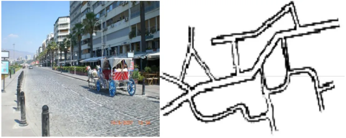
PATHS: Paths are the channels that we pass through, streets sidewalks, railways, canals are the paths that we observe during our trip. Paths are elements for people for their usage for circulation. People observe places while moving through paths (Lynch, 1960). (Figure 3.1 and 3.2)
Figure 3.1. Path Example: Kordonboyu, Izmir Figure 3.2. Kevin Lynch’s path sketch (Source: Lynch, 1960 p.52)
EDGES: Edges are mostly linear elements but not considered as paths such as walls, buildings, and shorelines. Edges can divide districts into parts, and determines where an area, space begins or ends (Lynch, 1960). (Figure 3.3)
Figure 3.3. Kevin Lynch’s node sketch (Source: Lynch, 1960, p.47)
DISTRICTS: Districts are places divided into meaningful zones for a reason. Each district is memorable in its context, and has its unique texture. There are some physical characteristics helping determine districts from other districts; these are; texture, space detail, form, building type, inhabitants, symbol, topography, use and activity. (Figure 3.4 and 3.5)
Figure 3.5. Kevin Lynch’s District sketch (Source: Lynch, 1960, p.47)
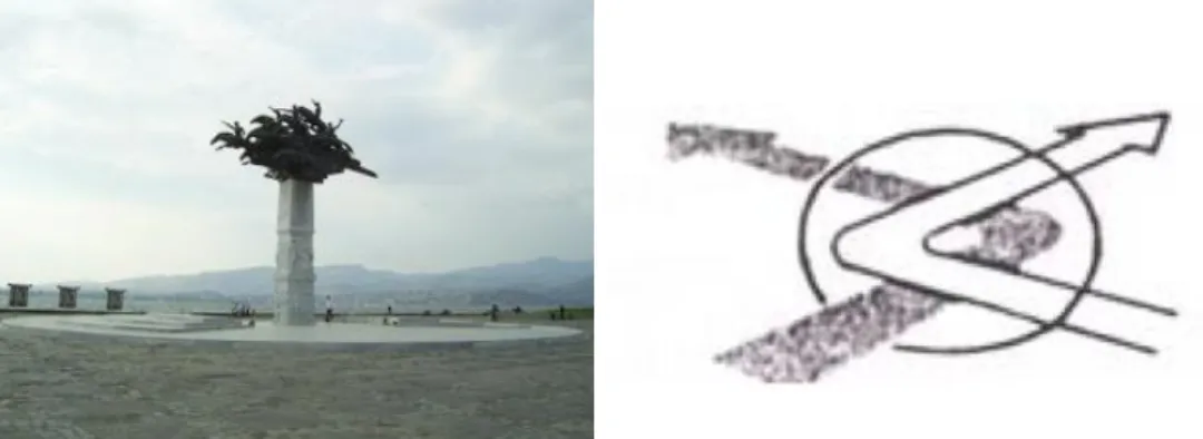
NODES: They gain their importance with their strategically placements. Nodes, which are mostly known and easy to find in an environment, are center of activities. People make decisions at node points in conclusion nodes should contain architectural information to make decisions (Lynch, 1960). (Figure 3.6 and 3.7)
Figure 3.6. Node example: Figure 3.7. Kevin Lynch’s node Gündoğdu Meydanı, Izmir example (Source: Lynch, 1960, p.47)
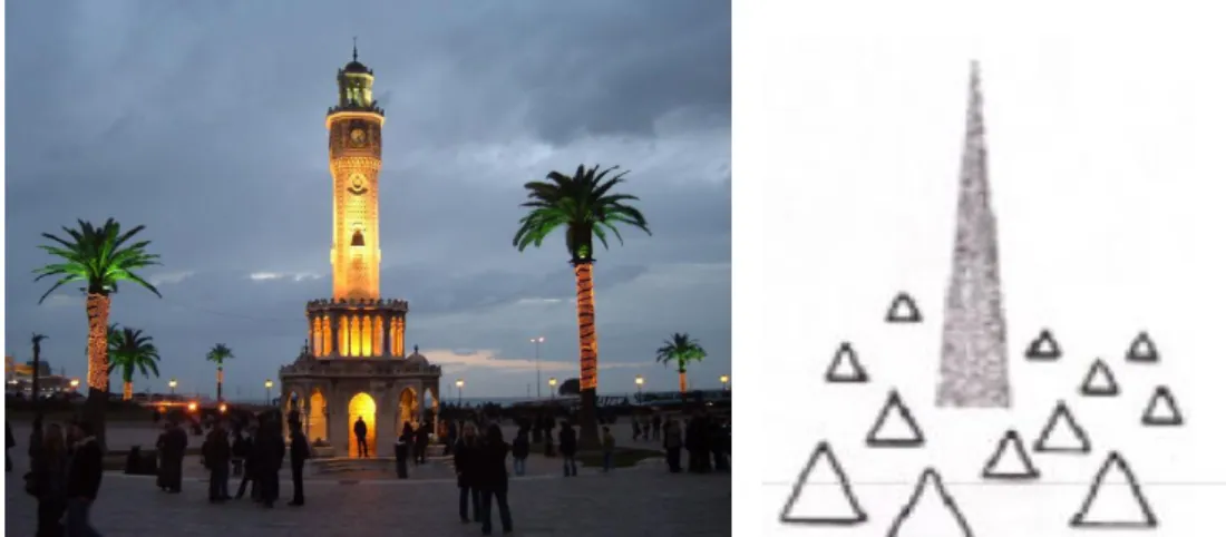
LANDMARKS: Landmarks are physical elements and their sizes can vary, they direct people to major nodes. When landmarks locate at junctions, it strengthens path decisions (Lynch, 1960). (Figure 3.8 and 3.9)
Figure 3.8. Landmark example: Figure 3.9. Kevin Lynch’s landmark Clock Tower, Izmir sketch (source: Lynch, 1960, p.48)
Secure way finding gives its possessors an important sense of emotional security and intensity of human experience (Lynch, 1960). While navigating in building, travelers want to feel safe and secure.
What is seen creates the decision in mind. In respect of Lynch, images soaked into memories and meanings as well as decision-making, remembrances carry weight on way finding. It can be said that, both directional signs, and elements and our memories create a mental map for wayfinding.
When Lynch and Passini are compared it is obvious to see different types of explanations on way finding. According to Passini wayfinding describes a person’s both cognitive and behavioral ability to reach spatial destination.
“Way finding decisions are hierarchically structured into plans which not only help to memorize routes in behavioral terms, but help to organize and record environmental information in the form of sequential, route-type representations” (Passini, 1984).
Passini breaks (explains) way finding in to three-stage performances; it starts with a 1) decision making, continuous with 2) Decision Executing and ends
with 3) Information Processing. According to Passini (1984) people engage in decision making when they travel on unfamiliar routes. Each decision is based on environmental information perceived from the settings. Turning right/left, taking the elevator and so on. Decision execution needs to happen at specific points on the route. Lastly Information processing is reaching the goal destination after whole stages.
In 1984 Passini’s research findings were published as “Wayfinding in Architecture” (1984) and a book with Paul Aurthur “Wayfinding – People, signs and Architecture” (1992) was published to explain their perspectives on wayfinding.
In a building with a complex organization like in a maze, routes may be blocked with dead ends. Environmental information describes the destination to the possessors with different ways, and with the information may be perceived directly in the settings, some retrieved from previous experiences, or some inferred from a combination of existing information (Passini, 1984).
When Lynch and Passini are compared Lynch describes wayfinding with environmental zones and geometrical shapes, in contrast to Passini. According to Passini wayfinding is formulates an actual plan and implements the plan (Muhlhausen, 2000). Passini’s wayfinding behavior has a hierarchically order and can be affected by previous environmental experiences. It is more than environmental zones, it is more about decision making and formulating it through actions.
3.1.3. Stages of Way Finding
If wayfinding action is entitled as a set of actions we can say that it is compound of hierarchy of some subsets. While experiencing an environment during navigation, wayfinding route consists of four stages: Orientation, route decision, route monitoring, and destination recognition (Downs and Stea, 1973). Definition of each stage is described below;
3.1.3.1. Orientation
Orientation: Orientation is a function of the mind involving awareness of three dimensions: time, place and person. By dividing space into smaller parts and using landmarks and signage, it is easy to determine orientation. Landmarks are easy to recognize and used for casual navigation. Landmarks provide strong orientation cues, such as Eiffel Tower is the landmark of Paris, it is not just a tower it is the global icon of Paris. "Landmarks may have different locations relative to a route. A landmark can either be at a decision point, at a route segment between two decision points. In San Antonio, TX, wayfinding is enhanced with color codes and landmarks and signage to make orientation in the downtown easily. (Figure 3.10)
Figure 3.10. Orientation example: San Antonio, TX
3.1.3.2. Route Decision
Route Decision: On the way of destination there may be more than one navigational choice. The number of choices should be minimized to reaching the destination. When there are more than one or more choices, people prefer the shortest route even if it is complex.
“Route following takes place after decisions have been made as to what segments are to be traveled and what turn angels are required to connect different segments” (Golledge, 1999).
Figure 3.11. Route decision example: Evacuation Plan Template
3.1.3.3.Route Monitoring
Route Monitoring: Refers to monitoring the chosen route to confirm that it is leading to the destination. To improve route monitoring, connect locations with paths and decision points such as where to change the way or make a return should be pictured to the user. With improving technology digital route monitoring devices (GPS), digital maps (Google maps) ease wayfinding task.
3.1.3.4. Destination Recognition
Destination recognition refers to recognizing the destination while going to the destination. To improve destination recognition, enclose destinations such that they form dead-ends, or use barriers to disrupt the flow of movement through the space. This process takes pace just before reaching the goal destination.
3.1.4. International Wayfinding Examples
In this part 6 international wayfinding approaches all over the world are selected among different orientation solutions. Also all 6 examples are collected as a result of literature review carried out in chapter 3. They were chosen since they all include different wayfinding elements. Examples are discussed under main topics of location, material, and design.
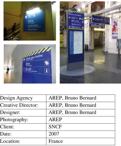
3.1.4.1. Transport – SNCF - France Railway Station (Digital Screen, Banner, Sign)
Signs at transportation places comprise a menu of different choices to the travelers; it gives multiple options to comfort them. Enhancing independent use of public transit, visitor should be informed when necessary. Railway stations in France are distinguished from others with special attention to visually impaired person.
The SNCF (Société Nationale des Chemins de fer français), French National Railway Corporation is the French’s national railway company, it has range of signages for passengers; information points, poster frames, monoliths through to totems. Signs provide identification and directions. (Figure 3.12. and 3.13) Most of it is readily understandable and even translated into English.
SNCF aims for a new typeface for visually impaired people and ophthalmologists. Designers proceeded multiple readability tests and surveys; as a result of series statistic results Achemine font has been set to satisfy more people. The font since has been in use in France over 800 train stations since 2007 (Wayfinding, 2012).
In SNCF mostly digital boars are chosen since information on boards changes frequently, universal signage system is used for international users. Information boards and banners located on user’s route and above eye level to be visible from distant. As material selection durable and easily cleanable materials
are chosen where people can reach and fragile screen boards where people cannot reach.
Figure 3.12. France railway station information points and monoliths, France
Figure 3.13. Poster frames, France
Design Agency AREP, Bruno Bernard Creative Director: AREP, Bruno Bernard Designer: AREP, Bruno Bernard Photography: AREP
Client: SNCF
Date: 2007
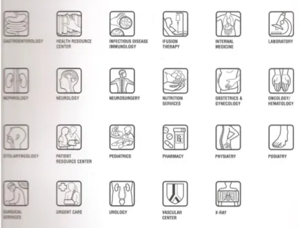
3.1.4.2. Healthcare – Palo Alto Medical Foundation Camino Medical Group (Pictograms, Tactile Boards, YAH Maps)
The frame of mind of visitors of hospital is often fuelled by stress and anxiety. Unknown terminology and being illiterate make people even more stressed. Comprehensive wayfinding and signing program are designed for Palo Alto Medical foundation to overcome these problems. For each department custom iconography is synchronized. Simple drawings of organs or connotations are used for pictograms. (Figure 3.14) Pictograms facilitate more people to understand.
Also Directory and folding guide brochure strategy was developed to provide an integrated family of signs addressing the needs for navigation (Wayfinding, 2012).
In this example main signage with pictograms for overcoming language barrier, tactile boards for visually impaired patients are used. (Figure 3.15)
Figure 3.15. Tactile directories
Design Agency GNU Group Creative Director: Dickson A. Keyser Designer: Howard Curtis Photography: Dickson A.
Client: Sutter Health
Date: 2007
3.1.4.3. Commercial – Maxi Joy Shopping (Color Coding, Banners)
Traffic signs guide visitors of Maxi Joy, colorful arrows and signs are used to draw target group’s attention. Islands full of good are located at the intersection of paths for taking attention and demonstration. Arrows and letterings on the floors aim to motivate people and to provide fun shopping experience (Wayfinding, 2012). (Figure 3.16) Color-coding corridors, corners and beams, ceiling-hang banners, traffic signs on floors are chosen, also primary and secondary colors are used to draw children attention.
Figure 3.16. Views from Maxi Joy shopping center
Design Agency Dan Pearlman
Markenarchitectur GmbH Creative Director: Marcus Fischer
Designer: Karin Hechinger Photography: diephotodesigner.de
Client: Spiele Max
Date: 2005
Location: Germany
3.1.4.4. Culture – Castles, Palaces and Antiquities in Rhineland – Palatine (Flag, wall mounted Banners, Signages)
There will be a uniform guidance and orientation systems to the visitors of United Nations Educational, Scientific and Cultural Organization (UNESCO) places. World Heritage sites located around the Rhine and Moselle, visitors will be guided through all cultural heritages with these wayfinding elements confirmed by UNESCO. Two firms Adler & Schmidt Kommunikations-Design / Meuser Architekten came up with a new wayfinding system that does away with signage, which distorts the architecture and which uses different kinds of wayfinding elements. The aimed to design wayfinding elements are similar to the primitive ones with using traditional materials; fabric, stone and bronze, and then they are added to these interactive touchscreen systems. They started with designing flags, banners and wall descriptions. (Figure 3.17) Location of the wayfinding elements can be seen from afar after analyzing the landscape. Where more than 2 paths intersect guide signs are situated for guidance (Wayfinding, 2012). Also designers
designed a special signage system for cultural places in Palatine (Figure 3.18) (Wayfinding, 2012).
Figure 3.17. Flags and Banners
Black solid signs with white lettering or orange and/or black hollow signs are designed for Palatine people.
Also, being considered for the blind tactile boards are located at entrance and necessary locations. Since some people are better at Model of the place help people to see the whole complex, be aware of present location and figure out how to find desired location. (Figure 3.19)
Figure 3.19 Wayfinding elements
Design Agency Adler & Schmidt
Kommunikations-Design / Meuser Architekten
Photography: Philipp Meuser, Hans-Peter Schmidt
Client: Landesbetrieb Liegenschafts – und Baubetreuung (LBB), NL Koblenz
Date: 2006
Location: 65 Landed Property in Rhineland - Palatinate
3.1.4.5. Education – Universities’ Wayfinding Hub (Signage, YAH Map, Pictogram)
The wayfinding hub system was developed for Universitys’ campus for students or who wants to explore the campus. The hub looks like a bus stop, has a covered resting area with the seat facing the map where one can sit whilst looking to the map (Figure 3.20). The structure consists of 2 parts, first one is two “O” shaped structures that display the route on which it is situated, and second one locates between the two “O” section shape structure and displays all possible routes on the campus. (Figure 3.16) Square designed signage with white lettering on red, yellow and green backgrounds in the hub helps for navigation, gives information about locations of departments, medical center, parking lot and so on. Hubs will color the area where they are situated, and also they are located on the main campus map.
Figure 3.20. Universities’ wayfinding hub
Design Agency Linda van Wyk Creative Director: Linda van Wyk Designer: Linda van Wyk Architect: Rohan Eicker
Date: 2008
Location: Pretoria, South Africa
3.1.4.6. Office – Dow Chemical Company, Houston Office (color Coding, Banners, Signage)
The Dow chemical company decided to make a change to reinforce their prestige in the market, they started to make a change in their corporate office. For having a better first impression, firstly designed the main reception area (Figure 3.22) secondly the whole wayfinding elements in the building. Company is aware of the importance of wayfinding elements.
Entrance and corridors are decorated with translucent photographic image murals; images were selected from Dow’s “Human Element” campaign. This campaign was based on that the missing element in the periodic table was human element. (Figure 3.23) Therefore, creating a focal point at the entrance works both for the prestige and for enhancing the cognition of the space. Wayfinding
elements in the building are mostly large vertical directional signs with warm colors. Each level coded with different colored signs and banners, also vertical and horizontal banners are located if necessary. (Figure 3.24) Also they color codded all floors and also colorful images are showing the direction ahead; warm photographic images leading to south and cool images leading to north (Wayfinding, 2012).
Figure 3.22. Entrance and reception area of DOW