Anatolia Antiqua
Oylum Höyük 1997-1998. Die spätchalkolithische Siedlung auf der
Westterrasse
Engin Özgen
,Barbara Helwing
,Atilla Engin
,Olivier Niewenhuyse
,Richard Spoor
Citer ce document / Cite this document :
Özgen Engin, Helwing Barbara, Engin Atilla, Niewenhuyse Olivier, Spoor Richard. Oylum Höyük 1997-1998. Die spätchalkolithische Siedlung auf der Westterrasse. In: Anatolia Antiqua, Tome 7, 1999. pp. 19-67;
doi : https://doi.org/10.3406/anata.1999.919
https://www.persee.fr/doc/anata_1018-1946_1999_num_7_1_919
E. ÔZGEN , B. HELWING , A. ENGIN , O. NIEWENHUYSE et R. SPOOR*
OYLUM HÔYÛK 1997-1998
DIE SPÂTCHALKOLITHISCHE SIEDLUNG AUF DER WESTTERRASSE 1. EINLEITUNG UND ZIELSETZUNG
Studien zum Spàtchalkolithikum im Syro- Anatolischen Taurus und Taurusvorland hatten in der Vergangenheit vor allem den letzten Abschnitt dieser Période in den Mittelpunkt ihres Intéresses gestellt, der durch einen intensiven kulturellen Kontakt und Austausch zwischen Mesopotamien und dem gebirgigen Hinterland wàhrend der sog. 'Urukexpansion' charakterisiert ist (Algaze, 1993 ; J. Oates, 1993). Erst in jiingerer Zeit hat sich das Forschungsinteresse starker auf den vorangehenden Zeitabschnitt, auf das Syro-Anatolische
Spàtchalkolithikum gerichtet. Dank zahlreicher Grabungen in den Stauseegebieten entlang des Oberen und
Mittleren Euphrat, darunter Nor§untepe
(Hauptmann, 1972 ; 1976 ; 1979 ; 1982), Korucutepe (Van Loon, 1978 ; Brandt, 1978) und Tepecik(Esin, 1970 ; 1971 ; 1973 ; 1974-75), sowie in Arslantepe (Palmieri, 1981 ; Palmieri - Frangipane 1983 ; Frangipane, 1993 ; 1994 ; 1995), Hammam et-Turkman (Akkermans, 1988b) und Tell Brak (Oates - Oates, 1991 ; 1993 ; 1994) sind wir inzwischen wesentlich besser iiber diese Période unterrichtet.
Aufgrund dieser Untersuchungen wird mittler- weile deutlich, dass es sich beim Syro- Anatolischen Spàtchalkolithikum keineswegs um eine Période der kulturellen Stagnation im
Windschatten der entstehenden sumerischen Hochkultur handelt. Parallel zur Entstehung der Urukkultur in Babylonien zeichnet sich im Taurusumfeld eine eigenstàndige Entwicklung komplexer Gesellschaftssysteme ab. Im archàolo- gischen Befund deuten Sondergebâude, Glyptik und keramische Massenproduktion die Entstehung von arbeitsteiligen hierarchischen Gesellschaften lange vor dem ersten Kontakt mit der Urukkultur an.
Fur ein besseres Verstàndis dieses Prozesses ist eine zuverlàssige chronologische Gliederung uner- làsslich. Eine derartige chronologische Untertei- lung des Spàtchalkolithikums konnte insbesondere anhand der Siedlungsstratigraphien von Nor§unte- pe, Tepecik und Arslantepe erarbeitet werden1. Es zeichnet sich dabei eine Gliederung in drei Stufen, SCh 1-3, ab, die den Zeitabschnitt vom Ende der Ubaidzeit bis zur Aufgabe der Uruksiedlungen in Obermesopotamien iiberspanen. Die Einbindung des Westeuphratlandes, und damit der Brucken- schlag nach Kilikien und Anatolien, in dieses Chronologiesystem bereitet jedoch erhebliche Schwierigkeiten. Daftir gibt es zwei Griinde : Zum einen liegen viele Pioniergrabungen, darunter Sakçagôzii - Coba Hôyiik (Taylor - Williams - Waechter, 1950), Tabara al-Akrad (Hood, 1951) und Tell e§-§eyh (Woolley, 1955: 5-6 ; French 1985 ; 1990) zwar im Westeuphratland. Zumeist *) Hacettepe Universitesi, Edebiyat Fakiiltesi, Arkeoloji-Sanat Tarihi Bôliimii, Protohistorya ve Ônasya Arkeolojisi Anabilim Dah, 06532 Beytepe- Ankara, Tiirkiye.
**) Bilkent University, Faculty of Humanities and Letters, Département of Archaeology and History of Art, 06533 Bilkent- Ankara, Turkey.
***) National Museum of Antiquities, POB 11114, 2301 EC, Leiden, The Netherlands.
1) Die relative Chronologie der Malatya - Elazig - Region war im Oktober 1995 Thema eines Seminars in Istanbul (Pers. Mitt. H. Hauptmann ; s. a. Trufelli, 1997 : 6 Anm. 2).
In Nor§untepe ergab sich eine Gliederung in die drei Stufen SCh I-III mit mehreren Subphasen. Stufe SCh I ist mit der spaten Ubaidzeit zu parallelisieren, die Stufen SCh II-III lassen sich mit Gawra IX- VIII verbinden. Das Ende des Spàtchalkolithikums fehlt in Norçuntepe (Giilçur, in Vorb. ; s. Schmidt, 1996 : 6-9 fiir eine Zusammenfassung der Stratigraphie). Eine parallèle Entwicklung làsst sich im Tiefschnitt von Tepecik erkennen (Esin, 1970 ; 1971 ; 1973 ; 1974-75 ; Giilçur, in Vorber.). In Arslantepe laufen die Phasen VIII und VII mit Norsuntepe SCh II und III parallel, das Ende des Spàtchalkolithikums entspricht in Arslantepe Phase VI A (Palmieri, 1973 ; Frangipane, 1993 ; Trufelli, 1997). Fur eine zusammenfassende Darstellung der SCh-Chronologie, vergl. Frangipane, 1993 ; Trufelli 1997.
20 E. ÔZGEN, B. HELWING, A. ENGIN, O. NIEWENHUYSE et R. SPOOR B |C i DiE !F i G H I J K
Oylum Hoyùk A
sind sie jedoch nur durch kurze, selektive Vorberichte bekannt. Besonders gravierend ist die Tatsache, dass das Ruckgrat der Westeuphratchro- nologie, die Amuqsequenz, in der spàtchalkolithi- schen Phase F einen Hiatus aufweist (Braidwood - Braidwood, 1960 : 226-258). Ausserdem zerfallt das Spàtchalkolithikum in mehrere régionale Gruppen (Frangipane, 1993). Bei dieser Regionalisierung bildet der Euphrat die Grenze zwischen der nordwestsyrischen Gruppe und der Balih-Habur-Gruppe. Ein Vergleich zwischen Fundorten westlich und ôstlich des Euphrat ist des- halb schwierig.
Es schien deshalb naheliegend, durch neue Untersuchungen zuverlàssigere Daten fiir das Spàtchalkolithikum in Nordwestsyrien zu erhalten. Die Grabungen auf dem Oylum Hôyiik, die unter anderem die Erstellung einer regionalen Kulturabfolge anstreben, boten sich fur dièse Zielsetzung an, da hier durch Erdentnahmearbeiten der Dorfbewohner an mehreren Stellen chalkolithi- sche Schichten offen lagen.
Die Dokumentation chalkolithischer Schichten hatte 1996 auf der Ostterrasse des Hiigels in Planquadrat Z 7 begonnen (Ôzgen - Helwing - Tekin, 1997 ; Ôzgen - Helwing - Engin, in Druck). Die Befunde in dieser Sondage bestanden jedoch iiberwiegend aus Schutt- und Planierschichten, so dass an dieser Stelle vorlàufig nicht weitergegraben wird. Stattdessen wurden die Arbeiten auf die Westseite verlagert, wo seit Jahren eine zweite Raubgrube von ca. 35 x 30 m Ausdehnung (Abb. 1: Planquadrate H/I/J 31-33) besteht. In ihrem Abbruchprofil waren massive Lehmziegelmauern und mit Brandschutt durchsetzte Raumfùllungen erkennbar. Ein Glockentopffragment und eine Krummtiille sowie Hâckselkeramik aus dem Abbruchprofil erlaubten eine Korrelierung des unteren Profilbereichs mit dem Ende von Amuq F, bzw. dem Beginn von Amuq G, bzw. mit der Urukzeit. Spàtchalkolithische Schichten lagen unterhalb dieser Stelle auf grôsserer Flàche frei. Ihre Untersuchung versprach Aufschliisse iiber die prà-urukzeitliche - spàtchalkolithische Besiedlung von Oylum Hoyiik.
Die Erosion des steilen Abbruchprofils hatte bereits begonnen, so dass insbesondere die nahege- legenen Flàchen bereits wieder mit Schutt iiber- deckt waren. Um der weiteren Zerstôrung des Hùgels in diesem Bereich Vorschub zu leisten und
zugleich einen Kulturabschnitt zu dokumentieren, der in der Htigelsequenz sonst praktisch unerreich- bar ware, wurde deshalb in den Jahren 1997 und 1998 auf der Westterrasse gegraben2. Es wurden drei Schnitte von je 4 x 4 m Kantenlànge geoffnet. Sie liegen, schachbrettartig versetzt, entlang einer Ost - West - Achse nebeneinander und entsprechen je einem Viertel eines Planquadrats. Die bisher ergrabenen Befunde zeigen, dass der alte Hiigel an dieser Stelle offenbar ein grosses Hanggefàlle auf- wies - die drei benachbarten Schnitte zeigen jeweils unterschiedliche Ausschnitte der stratigraphischen Sequenz, kônnen aber inzwischen korreliert wer- den.
2. DIE WESTTERRASSE : SCHICHTENFOLGE UND BEFUNDE (Olivier Nieuwenhuyse and Richard Spoor) 2.1. Introducing the trenches
Within the Western Trench, the excavations consisted of three 4 by 4 meter squares. These were oriented east-west, but not alligned on a row. According to the grid-system established at the hoyiik, these trenches were named, from east to west : J-31c, 1-3 lb and 1-3 lc (Abb. 1). The
excavations were located as close to the side of the Western Trench as possible, before erosion would make work here impossible. As a further incentive, it was expected that the oldest levels might be within reach close to the artificial section, deep in the mound. The emphasis lay on excavating deep soundings rather than broad, lateral excavations. The excavated remains have been stratigraphically analysed for each trench (section 2.2 to 2.4), after which the individual stratigraphies have been related to each other (section 2.5). The trenches document a period of occupation which lasted for several centuries during the earlier stages of the Late Chalcolithic period, Late Chalcolithic 1 (LCh 1) and Late Chalcolithic 2 (LCh 2) in our current terminology (see below). The occupation appears to have been situated on the western edge of a settlement, the precise extention of which cannot, at present, be ascertained.
2) Die 1986 begonnenen Ausgrabungen auf dem Oylum Hoyiik stehen unter der Leitung von Engin Ôzgen, Hacettepe Universitàt Ankara. Seit 1995 beteiligt sich das Deutsche Archàologische Institut Istanbul, vertreten durch Barbara Helwing, an den Untersuchungen (Ôzgen - Helwing - Tekin, 1997). Die Durchfiihrung der Kampagnen 1997 und 1998 war dank der finanziellen Unterstiitzung durch den Antikendienstes des T.C. Kiiltiir Bakanhgi, das Deutsche Archàologische Institut Istanbul und durch die grossziigige Forderung der Peter Dornier Stiftung Lindau moglich geworden.
22 E. ÔZGEN, B. HELWING, A. ENGIN, O. NIEWENHUYSE et R. SPOOR
OY98 J 31c strata 9b-9a
Zeichnung: Ugur Da§ OY 98 J 31c strata 8-7 Zeichnung: Uâur Dag Abb. 2 : Oylum Hôyiik 1998.
Areal J 31c strata 9a - 9b. Abb. 3 : Oylum Hôyùk 1998. Areal J 31c strata 8-7.
2.2. Trench J- 31C Introduction
Trench J-31C was excavated deeper (slightly over 5 metres) than the other two trenches. During the 1998 season, most emphasis was placed upon this trench, since the 1997 season had yielded several strata containing architecture. Also, because this trench was situated closest to the vertical side of the Western Trench, it was expected that work on this location would become impossible sooner than in the other two trenches. The vestiges have been grouped into nine different strata.
Stratum 9
Stratum 9 (Abb. 2) of trench J-31C contains the earliest features excavated so far within the Western Trench : A massive stone wall in the southwestern corner of the trench, wall 71 , functioned as a retaining wall for a thick deposit of regular layers of stones, re- used sherds and clay that filled the whole rest of the square. Stratum 9 has been divided into two sub-strata : stratum 9a represents the construction of this structure ; stratum 9b contains
some features and deposits situated on top of, or against wall 7 1 , but predate the features of stratum 8.
Wall 71 is situated in the south-west corner of the trench and runs from north-west to south-east. It has been partially exposed, and only a stretch of ca. 2.5 metres in length is visible. The wall had been preserved to a height of six courses with an absolute height of slightly over 2 m. Originally it must have been higher. The top of the fill behind the wall rises to 1 .5 metres above the level of the wall. The stone wall may therefore have had a height of originally 3.5 metres high. The unhewn stones vary in size, but on the whole are large : from 1 by 0.5 m to 0.75 by 0.3 m in diameter. In order to examine the internal structure of this large structure, a small rectangular sounding was excavated, measuring 2 by 4 metres and situated along the west-section of trench J-31C. This provided a cross-section, and exposed the (probable) base of wall 7 1 . The interior, northern wall face appeared to be rough and uneven. In contrast, the exterior, southern wall face was much more even. Here, the stones had been placed in such a way that their ends produced a regular wall face. The base of the wall seems to have been reached during the excavations.
This is indicated by a change in soil composition in the inner northern part of the structure. The light- grey fill with stones was replaced by the same dark- grey homogeneous clay that was found in the exterior, southern face of the wall. No new stones appeared below this transition. At the bottom of the fill, a layer of stones had been arranged to serve as a base.
The space north of wall 7 1 had been filled with carefully placed layers of small and medium-sized stones, alternating with layers of light-grey clay and with layers of re-used sherds. The clay used as fill material was different in colour as well as in texture from most of the other deposits excavated in the trench. It was 'sticky', compact and moist, and difficult to excavate. It seems likely that this material was retrieved from water-laid deposits, possibly from the small river that flows close to the mound, and it must have been selected from there in large quantities.3 The un worked stones packed in this clay were of varying sizes, from 40 cm to 10 cm in diameter. Interestingly, large numbers of apparently re-used grinding tools were found (n=45), mostly large grinding slabs and mortars. Although many of these ground stone tools were unbroken, they often showed very worn edges. More intriguingly, this fill contained massive numbers of 'Ubaid sherds. These are considerably older than the presumed Late Chalcolithic date of the platform, and must have been deliberately
excavated from elsewhere on the mound, in order to be used as filling material. 'Ubaid levels have been excavated on the opposite, eastern flanks of Oylum Hôyiik (Ôzgen - Helwing - Tekin, 1997 : 63-64), but no 'Ubaid material has previously been found within the western trenches. It is stressed that these 'Ubaid sherds do not provide a date for the feature.4 In many cases, when the stones in the fill were removed, it appeared that a layer of 'Ubaid sherds had been carefully and deliberately placed underneath it.5
South of these features, two different deposits against wall 71 have both been assigned to phase 9b. An upper-deposit {locus 70) consisted of black ashy lenses alternating with layers of humid, dark- grey clay. These layers sloped upwards against the top of wall 71, and partly covered it. They contained some small finds and restricted numbers of
sherds. Locus 70, however, may well represent washed material, that is unrelated to the use of the wall. Locus 70 must have been deposited when wall 71 had already partly or largely been covered, and had already gone out of use. Below these layers, running against the lower part and base of wall 7 1 , locus 72 was of a dark, compact, moist clay-like soil. Locus 72 appears to represent water-laid layers resulting from natural processes.6 No traces were found of activities of any sort. This deposit contained virtually no finds and yielded very restricted numbers of sherds. These sherds are mostly small, worn and show rolled edges. They are LCh 1 in date. In stark contrast to the opposite side of the wall, no 'Ubaid sherds have been found in these layers. This would confirm a relative date for the stratum 9 structure in the LCh 1 period. However, the distinct possibility exists that these sherds too represent washed material from later strata, and they can therefore only provide a terminus ante quern for the stratum 9 features.
The most likely interpretation of these features is a massive platform-like construction. Good parallels come from Hacinebi Tepe on the Euphrates, where several very similar monumental 'platforms' or terraces have recently been discovered (Stein and Misir 1994, Stein et al 1996 : Fig .2, 1997 : 1 13-4). At Hacinebi Tepe, within area A of the site, these various platforms are situated close to each other, and a large area of the settlement had apparently been devoted to these public structures. At Oylum Hôyiik, the amount of space occupied by this (single) structure is hard to ascertain at present. If we assume that the structure had a rectangular, symmetrical outline, it must have measured at least five metres in width. Since the centre of the structure is likely to be inaccessible for future research, the original lay-out and precise size may be lost forever. However, further excavation may reveal its southern limits and expose more of the area to the south-east of it, allowing an insight into the functions of this early public structure.
The current evidence seems to indicate that after the construction of the platform, and
following a period of use of unknown duration, natural processes of erosion and tell formation processes took place. Unfortunately, we have no indications of what was originally present on top of the plat- 3) Soil samples have been selected from these layers and will be submitted for further analysis.
4) Among the 'Ubaid sherds in the fill are restricted numbers of Late Chalcolithic I sherds (see below, section on ceramics) ; these provide a better date for the construction.
5) The sheer amount of 'Ubaid sherds collected in the fill argues for a deliberate process of selection and re-use. Whereas normally the sherds could easily be collected in restricted numbers of small pottery lots, the 'Ubaid sherds were transported to an alarmed sherd processing team in packages of wheelbarrows full of sherds.
24 E. ÔZGEN, B. HELWING, A. ENGIN, O. NIEWENHUYSE et R. SPOOR form, or what activities were carried out on it. The
surface of the platform appears not to have been preserved within the trench. The top of the light- grey fill layer containing stones and sherds sloped sharply from the east to the west, from the interior of the platform to the edge of it represented by wall 71. This suggests that the original top of wall 71
was removed, either by collapse or by deliberate destruction, after which the fill of the platform was partly washed away.7 A dark, compact ashy deposit covered the remains of the platform. It has been assigned to stratum 9b because it directly Covers the remains of the stratum 9 structure, and runs below the stratum 8 features. However, this dark layer is very different from the light-grey fill of the monumental structure, and is closer in composition to soil layers excavated in stratum 8. It should therefore perhaps more properly be considered to be part of stratum 8. Within this layer, a very irregular stone wall was exposed, locus 69, which runs over the remains of wall 71 at an angle. In this case, however, identification as a wall is less certain ; the stones may represent slope wash from the centre of the platform. It is unlikely that this is related to the use of the platform. If these stones do represent a wall, and not slope wash, it must have been built when wall 71 and the platform were already out of use.
Stratum 8
Stratum 8 (Abb. 3) consists of wall 58 and an associated pebbled surface. These features had been placed almost directly on top of the eroded surface of the stratum 9 monumental platform. However, no functional relationship is implied. As mentioned, the top of the stratum 9 platform indicates that a certain degree of erosion had taken place, and that it had been covered with a layer of soil before the stratum 8 features were constructed. It seems likely, therefore, that the stratum 9 platform had already gone out of use, and it may even have been barely visible. Only the slope of the stratum 8 deposits suggests that the broad outlines of the stratum 9 platform were still noticeable at the surface of the mound : the layers related to the pebbled pavement follow the slope of the remains of stratum 9, and make a curve in the south-western corner of the trench, where the massive stone wall of stratum 9 had once been .
Wall 58 is in many respects similar to wall 40 of stratum 5. Also its orientation is similar, running
from south-west no north-east in the north-western part of the trench. The base of wall 58 drops ca. 40 cm from the north-east to the south-west. The wall had been based upon a row of medium-sized to large boulders varying between 30 by 35 cm and 40 by 45 cm set into brown, homogeneous loam. Although most of these are unworked stones, two large basalt grinding stones had been reused as part of this foundation. Upon these stones was a single row of mud-bricks three courses high. The average size of the bricks measured 45 by 35 by 8 cm. The row of bricks was not continuous, but was interrupted in the southwestern part of the wall, just before the west-section. Precisely at this location, a large re-used basalt grinding stone had been placed with its flattened surface upward. Although the mud bricks may have been eroded from this part of the wall, it is not excluded that this represents a small doorway, and that the grinding tool had been re-used as a doorstep.
Next to wall 58, a surface paved with small stones and pebbles was exposed. This 'pavement' in fact consisted of a ca. 35 cm thick layer of hard, very compact brown soil which contained a dense concentration of small stones, pebbles and small, weathered sherds. Although this deposit was rather homogeneous, some horizontal layers of pebbles were noticeable, suggesting that this surface had been repaved repeatedly over a certain amount of time. Like wall 58, this surface drops ca. 50 cm from the north-east to the south-west ; this slope is reminiscent of the underlaying, eroded remains of the fill of the stratum 9 platform. The surface runs parallel to wall 58 and, although it had partly been cut by the ditch of stratum 7, it appears that it did not continue much further south from wall 58. After the pavement had gone out of use, a compact brown homogeneous soil was deposited, covering the pebbled surface completely and running against the base of wall 58.
Stratum 7
Stratum 1 (Abb. 3) is represented by a large, linear ditch or rectangular pit exposed in the southeast part of the square. The ditch is ca. 1 .75 m wide and runs for about 1.10 m. from south-west to north-east. The ditch was slightly over one metre in depth, and its section shows a regular, almost
convex base. The ditch cuts through part of the pebbled surface of stratum 8 and into the fill of the stratum 9 structure. Its flattened surface is sealed by the 7) However, no clear traces of washed fill were found against the southern, exterior face of wall 71 . Possibly the stones from locus 69 represent such wash.
OY98J 31c stratum 6
Zeichnung: Ugur Dag Zeichnung: Uâur Dag OY 98 J 31c stratum 5 Abb. 4 : Oylum Hôyùk 1997-98.
Areal J 31c stratum 6.
ashy deposits of stratum 6, and it must have been filled entirely before the stratum 6 features were built. No features could be associated with the ditch, and its purpose remains unknown. The feature may perhaps be related to specialized activities carried out near to the square. Equally, it may have been used as a drain, although the base of the ditch does not slope noticeably. Its fill consisted of a series of layers of a very compact, hard yellow to brownish-yellow loam.
It seems almost certain that this fill represents a largely secondary deposit, for among the sherds recovered from it are a large number of Late Halaf sherds. The Halaf period has so far not been attested as a secure archaeological horizon anywhere on the mound. These sherds, therefore, must have come from a nearby Halaf occupation level that was still close to the surface during the Late Chalcolithic period, but that is now deeply buried. Possibly, the ditch became filled with rain-wash erosion from adjacent mud-brick buildings using material from an earlier occupation level. Similar examples of 'reversed' stratigraphical deposition are known from many prehistoric excavations within the Near East, resulting from a tendency to prefer settlement debris over clean, alluvial soil to make mud bricks (D. Oates 1990). Good
comparisons include the Halaf sherds found within Middle- Assyrian mud-bricks at Tell Sabi Abyad (Nieuwenhuyse 1997), and the Samarra sherds
Abb. 5 : Oylum Hôyuk 1997. Areal J 31c stratum 5.
found in the foundation trenches of the Akkadian palace at Tell Brak (D. Oates 1982 :64).
Stratum 6
Stratum 6 (Abb. 4) consists of a ca. 1-1.20 metre thick deposit of a homogeneous series of very compact brown-grey to grey deposits
containing some mud-brick debris , pieces of charcoal and lime spots and, in particular, spots of dark grey- brown ashy material. The deposits constituting stratum 6 slope slightly to the south-south/west, following the slope of the features of stratum 8. The only structural feature related to this stratum is oven 48. Embedded within the ashy deposits that make up stratum 6, oven 48 was fragmentarily preserved but seems to have been build of mud-bricks. Some of these bricks had been preserved at the south-east corner of the structure. The structure was oriented north-west to south-east, and its surface measures 110 by 65 cm at the exterior
circumference. The oven seems to have had a slightly oval or rectangular shape, and had been dug into the surface. The floor of the fire-chamber consists of a dark-brown ashy loam, and was found at a lower elevation {ca. 30 cm lower) than the base of the associated mud bricks. The orange-red, compact burnt interior surface of the few remaining mud- bricks attests to the use of the oven .
26 E. ÔZGEN, B. HELWING, A. ENGIN, O. NIEWENHUYSE et R. SPOOR Stratum 5
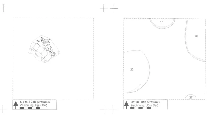
Stratum 5 (Abb. 5) consists of two walls (walls 40 and 50) and associated surfaces. A single row of un worked stones (varying between 33 by 20 cm and 1 6 by 13 cm) running from south-west to northeast in the north-eastern corner of the trench constitutes wall 40. The row of stones was within a shallow band of compact, brown loam that
undoubtedly forms part of the structure. Most likely these features only form the base of a wall, which was destroyed by activities related to stratum 4. No true floors were found in association with this wall. Interestingly, wall 40 follows almost the same course as the wall of stratum 8. In spite of the very restricted exposure, this may indicate a certain continuity in the use of space persisted from stratum 8 to stratum 5 on this part of the mound, in spite of the very different sort of activities that have been documented in strata 6 and 7. It also suggests a relatively short time-span between strata 8 and 5. Although the vertical extent of the deposits between these two strata (over 50 cm) would argue against this, this impression is strengthened by the analysis of the ceramics (see below). A stronger degree of continuity is attested between strata 5 and 4 by the location of wall 50. Wall 50 consists of pisé, and had been made of alternating layers of grey clay and compact brown loam, with a thickness of ca. 2 cm and ca. 1 cm, respectively. The wall itself had been preserved to a height of 40 cm, or three courses oï pisé bands, and had a width of ca. 70 cm. The wall runs parallel to wall 40, from south-west to north-east in the south-eastern corner of the trench. Wall 50 was situated directly below wall 28 of stratum 4, and it is not impossible that wall 40 in a later stage of its use was used as a base for the stratum 4 wall.
Associated with these walls, an exterior surface was exposed. It consisted of very compact, dark- brown tamped soil with sherds laying on it in horizontal position. The surface runs against the base parts of the walls and is nearly horizontal, sloping very slightly (for about 30 cm) from the east to the west. Close to wall 50, and situated on the surface with horizontal sherds, was a round feature
consisting of six stones with some additional smaller ones. The stones had been placed in a circle with a diameter of 47 cm. Although no traces of burning were observed, the feature may have been a small hearth.
Stratum 4
To a certain extent, stratum 4 (Abb. 6) may represent a remodeling of structures that had already been built in stratum 5. Wall 40 of stratum 5 went
out of use, and became covered by the ashy deposits associated with stratum 4. In contrast, wall 50 of stratum 5 appears to have been used, as a base for the construction of stratum 4 wall 28. The open area associated with stratum 5 continued to be used as an open area in stratum 4, and two fire
installations were constructed within this area. The construction of these installations might be used to subdivide stratum 4, but such a distinction was hard to sustain in the field, where a uninterrupted
deposition of thin, alternating compact and ashy layers north of wall 37 attest to a continuous use of this area, rather than suggesting an abrupt change.
The new feature of stratum 4 was the
construction of a building of which wall 37 may represent the northern limit. The remaining southern part of the building awaits further excavation. Wall 37, oriented north-west to south-east, consists of a single row of rectangular mud-bricks with a size of 49 by 35 by 8 cm, laid as stretchers. Bricks made of two different sorts of construction material were used : light-brown and light-grey, with a compact, dark- brown mortar in between them. The wall has a width of 35 cm, and had been preserved for a height of 7 courses, or 54 cm. No foundation stones had been used. Traces of a 2 cm thick dark-brown mud plaster were observed on the interior (southern) wall face. This wall plaster connects to a floor that was exposed south of the wall. The floor consisted of a 10 cm thick deposit of compact, orange-brown tamped soil. In contrast to the sloping surface northwards of the wall, the interior floor was levelled. It seems that wall 37 forms the northern enclosure of a building that lies in the unexcavated part south and south-west of the trench.
Wall 28, perpendicular to wall 37, also
consisted of rectangular mud-bricks. Similar to wall 37, these bricks had been laid as stretchers and without the use of a stone foundation. The wall is less regular, though, and did not show any plastering of wall faces. Three different types of bricks were used : light-brown, light-grey and dark-brown. The size of these bricks also varied, around an average size of ca. 50 by 36 by 8 cm. Brown-grey mortar was used to bind the bricks. The base of wall 28 had been preserved standing upright up to a height of four courses of bricks, ca. 40 cm, but the
remaining part of the wall had collapsed towards the south-east.8 A total of 13 courses of brick were counted, which, in upright position, would yield a wall of at least 1 .5 m. high. Following its collapse, processes of tell formation had gradually levelled the wall face that was turned upward, resulting in a smooth surface that sloped strongly towards the north-west.
North of these walls, an open area was located, 8) Theoretically, other suggestions can be put forward to^explain the diagonal position of these mud-bricks. 'Wall' 28 might rep-
OY98J 31c stratum 4
Zeichnung: Ugur Dag OY 98 J 31c stratum 3 Zeichnung: Ugur Dag Abb. 6 : Oylum Hôyùk 1997.
Areal J 31c stratum 4. Abb. 7 : Oylum Hôyuk 1997. Areal J 31c stratum 3. where various shallow but compact, brown surfaces
were excavated, alternating with deposits of light- grey and dark-grey ashy soil. These layers slope towards the north-west and comprise ca. 50 cm. Within this area, two fire installations were constructed. Oven 30 was exposed in the north-east quadrant of the trench, and had been preserved to a height of two courses of mud-bricks, or ca. 18 cm. It shows a more or less rectangular shape with a slightly curved northern end. The structure measures 1 .55 by 1 .08 m, and was oriented north-west to south-east. The feature had been built of mud- bricks of varying size and colour, including light- grey as well as dark-brown bricks, and with a compact, brown-grey mortar in between the bricks. The interior face had been burnt red. The fill of the oven consisted of soft, light blue-grey ashes containing pieces of brick from the collapsed oven wall. The base of the oven simply consisted of a thin layer of soft, black ash. Oven 34 is much smaller in size, and shows a rounded rectangular shape with a surface of 47 by 35 cm and with clear traces of burning on its interior. It had been preserved to a very restricted height {ca. 10 cm).
Stratum 3
A strong continuity in the use of space
persisted from stratum 4 to stratum 3 (Abb. 7). A new wall, wall 13, was built over stratum 4 wall 37, using this older wall as a basis for the construction of the new wall. As in stratum 4, this wall is likely to represent the northern enclosure of a building that remains to be excavated to the south of the trench. Within this building, in the space south of wall 13, a new floor was constructed. This floor consisted of a three cm thick layer of brown, compact tamped loam containing charcoal, limespots
and spots of light-brown and buff soil. A grinding slab was found on this floor. The area north of wall 13 continued to be used as an open area. In this exterior area several surfaces were deposited, consisting of alternating layers of grey to dark-grey ashy soil and more compact grey-brown to dark- brown soil containing pieces of mud-brick debris. Like in stratum 4, these surfaces gently sloped to the north-west, dropping ca. 40 cm from east to west. The collapsed remains of stratum 4 wall 28 must have been covered during stratum 3. Within resent a terrace-wall like construction that might even have been purposely constructed in a diagonal position. Terraced constructions have also been attested in trench 1-3 1C, stratum 6. This option, however, seems unlikely. The evidence suggests a gradual move from stratum 5 to stratum 4, while, moreover, stratum 5 wall 50 may have been used as a basis for wall 28.
28 E. ÔZGEN, B. HELWING, A. ENGIN, O. NIEWENHUYSE et R. SPOOR
Abb. 8 : Oylum Hôyuk 1997. Areal J 31c stratum 2. this open area, two simple hearths were constructed. Hearth 23 consisted of a shallow, rounded rectangular depression measuring 80 by 70 cm and with a depth of ca. 10 cm. It had been filled with dark brown to black ashes. Hearth 24 was similar, consisting of a shallow, rounded depression with a depth of ca. 10 cm, filled with light blue-grey burnt material.
Although wall 13 displays a similar location and orientation as stratum 4 wall 37, its
construction shows some new features. The wall itself had been preserved to a height of four courses of brick, 42 cm high. This restricted height may perhaps be related to leveling activities during stratum 2, when the basis of this wall was re-used. Mud-bricks of varying sizes were used, with compact brown mortar in between them. The wall was broader than the stratum 4 wall underneath it, as it was constructed of one-and-a half row of mud bricks, measuring 65 cm in width. In addition to using stratum 4 wall 37 as a basis, wall 13 broadens at the base, giving its foundation extra strength. Wall 25 was abutted perpendicular to the north of wall 13, but the two walls
were connected by a layer of dark-brown, compact mud plaster. Bricks of varying size were used for
wall 25, ranging from 41 by 39 cm to 40 by 30 cm. Compact brown mortar was used between the bricks. Wall 25 measured ca. 2 m in length and had a width similar to wall 13. Like wall 13, this wall broadens at its base, to provide stronger foundation. This wall seems to have been less carefully constructed than wall 13, and, rather than supporting a roof, it may have served to fence off an area, or to provide protection against the wind. It has been preserved for a height of 4 courses of brick, about 40 cm, and it may even have been a low bench rather than a true wall.
Stratum 2
Stratum 2 (Abb. 8) represents a continuation and modification of the structures of stratum 3, but at the same time some changes in spatial
organization are noticed as well. The part of the building that was excavated in stratum 3 continued to be used, but underwent a phase of reconstruction . Wall 13 of stratum 3 was re-built on a higher level. A new series of bricks was put on top of the remains of the wall, which was leveled almost to its base for this purpose. Stratum 2 wall 13 had been preserved to a restricted height of two or three courses of mud-brick, ca. 20 cm. Similar to stratum 3, wall 13 was build of bricks of varying size, and consisted of more than a single row of bricks. Further, south of the reconstructed wall 13, a new floor was constructed, ca. 40 cm above the stratum 3 floor. This new floor, locus 21 , consisted of a 2 cm thick layer of compact, grey loam.
Further modifications of stratum 2 consist of the construction of two new walls, walls 8 and 10, adjacent to the remains of stratum 4 wall 25. Wall 25 itself was also re-used, as a basis to construct feature 18, which may have been either a bench or a true wall (see below). It is unclear if the space delimited by walls 8 and 10 was roofed or represents an open area. No clear floors were found, such as in the room south of wall 13. A doorway in wall 10 provided entrance from the north. At some stage during stratum 2 this doorway was blocked with mud-bricks.9 Wall 8 appears to have been bonded into wall 13, and consisted of square and rectangular, light-grey bricks, with a size varying from 48 by 30 by 8 cm to 40 by 35 by 8 cm. Compact dark-brown mortar had been used for binding those bricks. Both faces of the wall had been covered with a layer of mud plaster. The wall was ca. 60 cm wide, and had been preserved to a 9) Theoretically, the blocking of the opening in wall 10 may be used to differentiate stratum 2 into strata 2a and 2b. However, few other activities or stratified deposits can clearly be associated with the blocking of this door, and such a distinction has not been made here.
height of 4 courses of brick, ca. 40 cm. Wall 8 continues to the north-east into wall 10, which forms part of the same structure. Between wall 8 and wall 10, however, the western wall-face shows a slight disruption.
Adjacent to these walls, the remains of stratum 3 wall 25 were used as a basis for constructing feature 18. It is not clear if this feature represents a wall or a low bench. A row of stones was placed on top of the remains of stratum 3 wall 25. These stones follow the course of walls 8/10, but make an abrupt corner to the north-west. These stones apparently served as a foundation for a row of mud- bricks, of which only a few had been preserved. In the corner between wall 13 and feature 18, a clear exterior surface, locus 16, was exposed, consisting of compact brown loam with whitish-grey ashy and light-buff spots. On this surface, various ceramic bowls, a series of pounding stones and a number of lithic implements had been left apparently in situ, and attest to the use of this space for a variety of domestic activities. Further, to the west of surface 16, a row of small stones was exposed ; the feature to which these stones may have belonged had, however, been destroyed by stratum 1 pit 53.
Stratum 1
Stratum 1 is not associated with building activities or any other architectural features. Due to the slope of the surface, stratum 1 has largely been exposed in the north-western corner of the trench. Stratum 1 consists of a series of alternating dark- grey and light-grey ashy layers. During stratum 1, the slope on this part of the mound became much stronger, ca. 1 m. from east to west.10 The only features included within this strata are two circular pits. Pit 53 had a maximum diameter of 1 .12 m and a depth of 36 cm, and had cut somewhat into the stratum 2 walls. Pit 52, situated in the north-eastern corner of the trench, had a maximum diameter of
1 .10 m and a depth of ca. 50 cm. Stratum 0 (topsoil)
Erosion from the mound had covered all Chalcolithic remains with a thick deposit of uncomfortably compact layers of brown crumbly loam, alternating with grey ashy soil. Pieces of 20th century plastic and, in particular, very large stones were part of this top layer ; the origin of these
stones became clear after looking upward to the sections in the mound above the trench. The thickness of this layer varied from over lm closest to the mound to ca. 0.5 m farther away from it.
2.3. Trench I-31b Introduction
Trench 1-3 lb, in contrast to the other two trenches, yielded few vestiges. The only features consisted of a series of pits and a human burial. In this trench, the excavated features largely consisted of thick ashy deposits. These slope slightly from south to north, and sharply from east to west. As result, a layer that is found close to the topsoil in the south-eastern corner of the trench is often at the base of the trench in the north-western corner (see Abb. 16). Since these ashy layers were very similar in terms of soil colour and texture, they were often difficult to distinguish during excavation. In spite of this setback, trench 1-3 lb may provide a strati- graphical connection between trenches J-31c and I- 31c, linking the ceramic sequences from these two trenches. A total of 7 strata have been
distinguished. Stratum 7
Stratum 7 consists of a compact brown-grey surface, which appeared below the ashy soil layers of stratum 6. This layer was not entirely horizontal but sloped somewhat to the north-east. Sherds were found lying horizontally on this compact layer. A small rounded fireplace or ash pit, locus 25, had been dug into this surface. Locus 25 is a shallow pit, with a diameter oi ca. 1 m and of a depth of 16 cm. It had been filled with soft black and yellowish ash, and contained an abundant amount of sherds. This stratum has not (yet) been further excavated.
Stratum 6
Stratum 6 consists of a thick (1 m to 1.30 m) level of ashy layers, which had been deposited over the compact surface of stratum 7 . Stratum 6 is not a single, homogeneous deposit, but contains alternating, heterogeneous grey-brown, light-grey and dark-grey ashy layers, containing large amounts of ashes, limespots, small stones and pebbles, and perhaps pieces of mud-bricks. Copious amounts of 10) As should be clear from the descriptions, the various Late Chalcolithic strata in the trenches generally slope strongly from the east to the west. This slope continues into the walls of the Western Trench, as can be observed in the sections for several meters high above our working surface. Within these sloping, alternating grey to dark-grey brown ashy layers, mud-brick walls are clearly visible.
30 E. ÔZGEN, B. HELWINC, A. ENGIN, O. NIEWENHUYSE et R. SPOOR
OY 98 I 31b stratum 6
Zeichnung: Ugur Dag OY 98 I 31b stratum 5 Zeichnung: U§ur Dag Abb. 9 : Oylum Hôyuk 1997.
Areal I 31b stratum 5 Bestattung loc. 24. pottery had been discarded within these layers. Similar to strata 3 and 1 , these layers slope sharply from the east to the west, and, less significantly, from the south to the north.
Stratum 5
Stratum 5 (Abb. 9) contains a (single) human inhumation, locus 24. The body was found in crouched position, lying on its right side and with its face towards the north-east." No burial gifts had been provided. A short stretch of mud-brick wall or, perhaps more likely, a bench, had been placed inside the burial pit, alongside the body. This bench had a length of ca. 1.4 m, and consisted of three courses of brick with a size of ca. 35 x 30 x 8 cm. To the other side of this bench some bricks had been placed standing upright. A contour line suggests a rounded burial pit with a diameter of ca.
1 .4 m, containing both the mud-brick bench and the body. Very similar burials have been excavated in stratum 7 of trench 1-3 lc (see below).
Stratum 4
Stratum 4 (Abb. 10) consists of three pits of varying shape and size : loci 27, 10 and 23. These
Abb. 10 : Oylum Hôyuk 1997. Areal I 31b stratum 4. pits need not be, and probably were not, in
contemporaneous use. Their relationship with the burial of stratum 5 , moreover, is unclear. Although these pits most likely post-date the burial, it is not excluded that they are contemporary. Due to the slope of the mound, these pits had not been dug from the same elevation (see Abb. 16) ; the lowest of the three, pit 23, is situated ca. 1.20 m below the level of other two pits. The function of these pits is uncertain, but is seems unlikely that they were intended to contain domestic refuse. The fill of the pits contained virtually no finds, with the exception of restricted numbers of eroded sherds. Pit 27 represents the smallest of the three. Situated in the south-eastern corner of the square, it has a circular mouth of about 0.5 m. The pit itself is conical : the pit broadens near the base. Dug at a slightly oblique angle, almost perpendicular to the sloping surface, it reaches a depth of ca. 0.9 m. The pit was filled with a grey-brown, very homogeneous and compact fill. Pit 10, situated in the north-eastern comer of the square, has the same shape as pit 27, but on a considerably larger scale. The pit may have had a circular or, perhaps, oval-shaped opening, which must have been at least 4 m in diameter. Its conical shape reaches a depth of at least 1 .5 m, but the base was not reached during the excavation. The lower part of the interior 1 1) The physical-anthropological analyses of the skeleton will be presented elsewhere.
surface had been covered with a thin layer of white plaster. This pit has a complex history of infilling. The upper fill consists of alternating light-gray and red-brown ashy layers, suggesting a use of the pit in relation to fire. This upper- fill of the pit may have been dug out again at a later stage, as is suggested by a homogeneous, grey-brown cut in this ashy soil. The lower part of the pit shows a
homogeneous, compact brown fill, containing some dark- gray ashy lenses. Pit 23, finally, shows a roughly circular opening with a diameter of ca. 1 .8 m. The interior wall appears to have received a thin coating of white plaster.
Stratum 3
Stratum 3 consists of various ashy layers, most of which could not be excavated individually. These layers form a thick (ca. 1 .5 to 2.5 m.) deposit which slopes significantly from the east to the west. Stratum 3 appears directly below topsoil in the eastern part of the trench, but from there it slopes ca. 1.5 m to the base of the trench in the western part. On the whole, these layers are less
homogeneous and somewhat more ashy than those of stratum 1 . They consist of various light greyish-brown layers containing abundant pieces of charcoal and lime particles, alternating with thin, dark-grey layers of almost pure ashes. Pieces of mud-brick were occasionally observed, but no features were attested.
Stratum 2
Stratum 2 consists of a single pit, locus 15. Situated directly against the northern section baulk, probably excactly half of the pit has been
excavated. The pit has a cylindrical shape with a circular opening. Its diameter measures ca. 1.5 m and the pit reaches a depth of ca. 1 m. The base and the lower part of the walls had been covered with a thin layer of white plaster. The pit had not been dug vertically, but was dug perpendicular to the existing slope of the mound. Its base slopes somewhat from the east to the west. The compact, homogeneous grey-brown fill of the pit contained restricted numbers of small and eroded sherds, suggesting a gradual infilling by erosion.
Stratum 1
Stratum 1 consists of the deposit directly below topsoil, but covering pit 15 of stratum 2. Due to the slope of the tell , stratum 1 has only been attested in the western half of the sounding. As can perhaps best seen in the drawings of the northern and southern sections (see Abb. 16), stratum 1 slopes sharply from the east to the west. Stratum 1 is built up of a series of rather homogeneous grey-brown ashy layers alternating with thin, dark-grey ash layers. The lowest of these layers contained pieces of mud- bricks, but no features were observed.
Stratum 0 (topsoil)
The topsoil was the most significant in the north-east corner of the trench with a thickness of ca. 1 m, sloping towards the south-west. The surface below topsoil was irregular, as the villagers had left deep cuts into the Chalcolithic levels. Topsoil consisted of a series of water-laid deposits mixed with stones of all sizes and with 20th century refuse including pieces of plastic and metal.
2.4. Trench I-31C Introduction
Trench 1-3 lc yielded the latest Chalcolithic levels excavated as yet in the Western Trench. Unfortunately, the upper-most levels of this trench have been very badly preserved. Nevertheless, below these upper-levels the trench yielded strata containing well-preserved features, which are associated with notable changes in the pottery
assemblage compared to the other two trenches (see below). Thus far, nine strata have been
distinguished. Stratum 9
The lowest layers excavated in trench 1-3 lc consist of a series of alternating grey to dark-grey ashy layers that slope considerably towards the west and north-west. Due to the slope of these layers, stratum 9 has only been exposed, and partially excavated, within the south-eastern part of the trench, where it comprises a layer of about 30 to 40 cm thick. No features have been attested within stratum 9.12
12) At the end of the 1998 fieldwork season, traces of two walls started to appear at the surface of trench 1-3 lc. These traces await future excavation.
32 E. ÔZGEN, B. HELWING, A. ENGÎN, O. NIEWENHUYSE et R. SPOOR
n U48
52
OY 98 I 31c stratum 7 Zeichnung: Ugur Dag
51 50
OY 98 I 31c stratum 6 Zeichnung: Ugur Dag Abb. 11 : Oylum Hoyuk 1998. Areal I 31c
stratum 7 Bestattungen loc. 48, 50-52. Abb. 12 : Oylum Hoyuk 1998. Areal I 31c stratum 6.
h't. I '
OY 98 I 31c stratum 5 Zeichnung: Ugur Dag
Abb. 13 : Oylum Hoyuk 1997. Areal I 31c stratum 5.
Stratum 8
Stratum 8 consists of a thick, ca. 80 cm thick layer of rather homogeneous, light grey-brown soil containing some small pieces of eroded mud- bricks, occasionally alternating with a dark- coloured ashy layer. Stratum 8 covers the whole trench, and slopes gently towards the west. The only feature that can be related to this stratum is a large pit, locus 53, which had been dug into the stratum 8 layers in the south-eastern corner of the trench. Pit 53 consists of a circular depression ca. 50 cm deep, with a plaster-lined base. It can not excluded that stratum 8 indicates that this part of the mound was unused for an unknown period of time. However, a restricted number of small metal objects, other small finds and some large pottery fragments found in this stratum suggest the pressence of human activities nearby.
Stratum 7
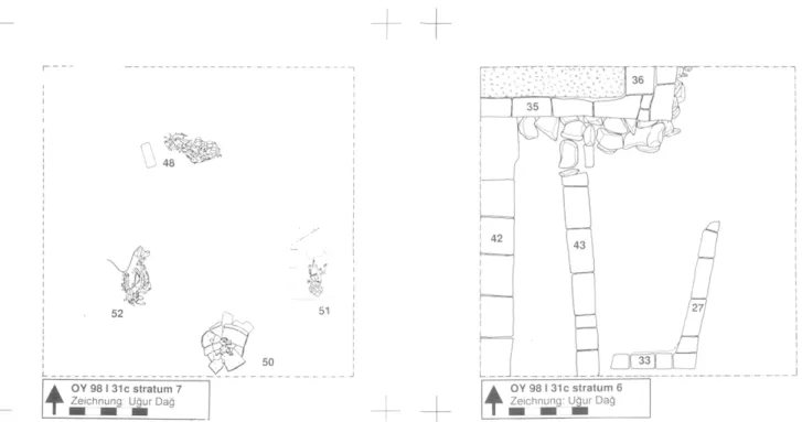
Dug into the soil layers of strata 9 and 8, four human inhumations have been found (Abb. 11), all apearing at about the same absolute elevation.13 Obviously, they need not be exactly contemporary. Moreover, their relationship with pit 53 of stratum 8 is uncertain, and the pit and the burials may well belong to the same phase of occupation. These four burials show similarities with the stratum 5 burial of trench 1-3 lb. Four of the five burials represent pit inhumations with the bodies in crouched position, the exception being a burial within a ceramic vessel (burial 50). 14 Burial goods have been provided in three of the five cases. In most cases, mud- bricks had been arranged within the burial pit. These bricks may represent a simple burial chamber, or, alternatively, could represent low benches.
A similar burial practice has been attested at Hacinebi Tepe (Stein et al. 1996 : 95, Fig. 13).
Burial 48 consisted of a body in crouched position with the head towards the east, placed within a pit of 80 by 30 cm and oriented east- west. Two brown mud-bricks had been placed in vertical position at the western end of the pit. Gifts consisted of
a stone stamp seal and four small beads. Burial 51 had been placed in crouched position with the head to the south, in a pit measuring 100 by 75 cm. Two rows of three regular bricks each had been placed on either side of the body. In addition, smaller
ments of brick were found at the northern end of the pit. An ornament containing 12 beads made of various materials was found at the location of the pelvis. Burial 52 was very badly preserved, but consisted of a body lying with the head to the south, without any burial gifts. Burial 50, in contrast to the others, consists of a burial crouched in a large ceramic vessel, which had been placed in a rounded pit with a size of 105 by 70 cm and oriented east- west. Two red-brown, regular bricks had been placed to the west of the jar. A stone and some smaller, irregular bricks had been placed around and below the jar to the east and north-east. No burial goods had been provided with this burial.
Stratum 6
Stratum 6 (Abb. 12) consists of at least one domestic building, represented by two walls, loci 35 and 36, which form a corner of a room in the north-western part of the trench. The mud-brick walls of this building had been preserved for over 50 cm, and had been erected above a solid stone foundation which had been dug into the stratum 1 layers for about one metre deep. Remains of perhaps a second building, locus 42, also with a stone foundation, were exacavated along the western edge of the trench. To the east of this second building, and parallel to it, runs a wall, locus 43, which had been terraced into the stratum 7 layers as well. This resulted in a difference in elevation of ca. 50 cm between the surface to the east of wall 43 and the surface of the small, dead-end street between walls 43 and 42. On both sides of this terrace wall clear surfaces were exposed, on which various grinding tools, some large pieces of animal bone, large pottery fragments as well as some complete vessels had been left.
Building 1 consists of two bonded walls perpendicular to each other, running almost exactly east-west (wall 35) and north-south (wall 36). Both walls were made of brown mud-brick, based on heavy stone foundations. The foundation of wall 36 measures ca. 90 cm. wide, and had been dug into the mound for ca. 90 cm. This foundation
consisted of two rows of medium-sized to large stones, with an average size of ca. 40 by 40 cm, placed four stones high. The wall itself consisted of two rows of mud-bricks, with a size of ca. 45 by 30 by 8 cm and placed as headers, which had been preserved to 1 3) The possibility cannot be excluded that the burials have been dug from the stratum 6 surface, and are contemporary with stratum 6. This is suggested by the location of burial 48, which appeared within the corner made by the stone foundations of stratum 6 walls 35 and 43. Rather than stratum 6 having been terraced into earlier levels containing stratum 7 burial 48, this might indicate that burial 48 was made after the construction of the stratum 6 buildings. However, this option is less likely for the other burials, which appeared stratified below stratum 6 features.
34 E. ÔZGEN, B. HELWING, A. ENGIN, O. NIEWENHUYSE et R. SPOOR a height of 4 courses, ca. 50 cm. The width of this
wall measured ca. 90 cm. The foundation of wall 35 consisted of two rows of similar stones, built two stones high. In addition, two rows of mud- bricks, each four courses high, had been placed on top of this stone foundation. Above these lower four foundation courses, the wall continued as a single row of mud-bricks with a width oica. 45 cm. These two walls delimit an interior space in the
north-west corner of the trench, of which the floor and walls had been plastered. The plaster floor slopes slightly towards the west. Following its abandonment, this space had become filled with a compact, light grey-brown fill that contained almost no sherds or other finds. Building 2 consists of a single wall, wall 42 and its foundation, which consisted of small to medium-sized stones. It seems likely that these two buildings are part of a single, as yet unexcavated structure. The base of the foundation of wall 42 is horizontal, and at the same elevation as the base of walls 35 and 36.
These constructions had resulted in a small space between wall 42 and terrace wall 43. Wall 43 consisted of a single row of light-grey mud-bricks with a size of ca. 45 by 35 by 8 cm, placed as headers. The wall had been erected without a stone foundation, but two stones placed in a row below wall 43 and abutting the stone foundation of wall 35 of building 1 may have served as foundation. The presence of these stones suggests that wall 43 was constructed with buildings 1 and 2. Wall 43 had collapsed into the space between walls 42 and 43, but had still been preserved to a height of four courses of brick, ca. 45 cm high. On both sides of the terrace wall clear surfaces were exposed. Within the street between building 2 and terrace wall 43, two superimposed surfaces were found. This little space may have been used as a discard area for domestic utensils. The upper surface, which was about 40 cm below the surface on the eastern side of the wall, consisted of a compact grey-brown layer which was similar to the surface east of wall 43. On this surface some large fragments of discarded pots were found. These include two large fragments coming from the same vessel, but which had been deposited on the northern and southern part of the space, ca. 2 m apart. An earlier surface was exposed ca. 20 cm below the level of upper one, consisting of a thin (ca. 5 cm) layers of reddish-brown soil with traces of whitish plaster. A large fragment of a vessel and a grinding stone as well as some large chunks of an animal carcasse had been left on this surface.
East of wall 43, a surface was exposed that sloped gently upward for about 20 cm moving from wall 43 to the east-section baulk. This surface
sisted of a compact, grey-brown layer, on which various items were found, including a number of grinding tools and a complete casserole. These are likely to represent primary or secondary refuse rather than in situ objects. On this level, two frag- mentarily preserved walls were found, loci 27 and 39, each consisting of a single row of grey-brown mud-bricks with a size of 45 by 30 by 8 cm, and preserved to a height of four courses, ca. 40 cm high. Wall 39 abutted, or was cut by terrace wall 43. The walls had been constructed not entirely perpendicular to each other, and showed a white plaster layer on their interior.
Stratum 5
Stratum 5 (Abb. 13) consists of the remains of two ovens, loci 9 and 10, and of their related ash middens. Stratum 5 is restricted to the eastern half of the trench, where it runs against and covers what remained of the stratum 6 features. To the west, stratum 5 gets thinner, and here stratum 4 lies directly on top of the remains of stratum 6. Oven 9 consists of an U-shaped semi-circle made of nine rectangular, brown mud-bricks with a size of 30 by 20 by 10 cm. The bricks had been placed in vertical position, and grey mortar had been used between the bricks. The construction measures 110 by 105 cm. The oven had been dug into the ground, and its base consisted of a slightly concave depression ca. 10 cm deep. The interior wall-face consisted of an orange, compact layer. The oven had been filled with deposits of black and light-grey ashes, covered by a layer containing orange-brown pieces of collapsed oven wall. The opening of the oven extends into a key-hole shaped depression in front of the oven. Leading from there towards the northeast, a layer of heterogeneous ashy soil was excavated, consisting of dark-grey, almost pure ashes, mixed with light- grey ash and with compact, orange-red pieces of burnt loam. These ashes run against the top of the remains of the stratum 6 walls, but do not extend much further to the south. Within this ashy area, a smaller hearth was found, locus 10. This oven had been oriented with its opening towards oven 9, and consisted of a small (0.7 by 0.5 m), U-shaped depression with a compact, orange-red burnt interior.
Stratum 4
Stratum 4 consists of a brown to grey-brown, homogeneous and rather soft soil without any special features, distinct in soil colour and texture from stratum 3. Stratum 4 is the thickest in the north-east corner of the square, where it comprises ca. 80 cm.
From there it slopes strongly to the south-west, where this stratum comprises ca. 40 cm.
Stratum 3
A distinct, homogeneous reddish-brown, compact soil layer without features constitutes stratum 3. This layer slopes sharply from the east to the west, and it has only been attested in the western half of the trench. Stratum 3 had been cut by strata 1 and 2. Stratum 3 may represent slope wash. Its distinctive reddish colour was the reason to attribute this layer to a separate stratum .The thickness of stratum 3 varies from ca . 80 cm in the north-east to only a few cm in the south-west.
Stratum 2
Stratum 2 consists of a large disturbance that had been dug vertically into stratum 3 for about 0.7 m deep. Within this disturbance, the eroded remains of a wall, locus 4, and a plastered floor were found, suggesting a building terraced into an earlier tell surface. A terraced construction has also been attested for stratum 6. Stratum 2, which had in its turn been cut by pits of stratum 1 , covers most of the western half of the square. Stratum 2 seems to have been orientated from the north to the south, perpendicular to the existing slope of the mound. Its fill consisted of a homogeneous light grey- brown soil. Wall 4 consisted of a single row of greyish-brown bricks placed as headers. The size of the bricks measured ca. 40 x 32 x 10 cm. The wall runs from the north-west to the south-east, and had been preserved a single course high. To the west of the wall, at about 10-30 cm above the level of the remains of this wall, a fragment of a thick (ca. 8 cm), light-grey plaster floor was exposed (see Abb. 15 : west-section).
Stratum 1
Stratum 1 consists of five pits, loci 12, 20, 21, 38 and 39. However, although none of these pits yielded modern refuse, in terms of soil colour and texture their fill is similar to that of the topsoil layer, and it is not excluded that they are modern disturbances. The pits all have been dug vertically and show a circular shape. The diameter ranges from 0.6 m to 1 .4 m, and the depth of the pits varies from 0,3 m to 0.8 m. Pit 12 differs from the other four pits. It shows a circular shape with a vertical wall and with a depth of ca. 35 cm . The interior of pit 12 had been coated with a thin layer of white plaster. It had been filled-in with greyish, ashy layers.
Stratum 0 (topsoil)
Similar to the other two trenches, recent erosion from the mound and refuse from the modern village had formed a thick layer of topsoil. This layer was the thickest in the eastern part of the trench (over 60 cm), and less significant in the western part of trench (40 cm). Below this layer, the exposed surface was not entirely even. A series of small pits that have been ascribed to a separate stratum (stratum 1) may, in fact, represent modern pits. In addition, a large, 40 cm to 60 cm deep circular pit had been dug in the south-east corner of the trench, which was filled with recently formed deposits containing plastic, metal and other contemporary refuse.
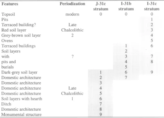
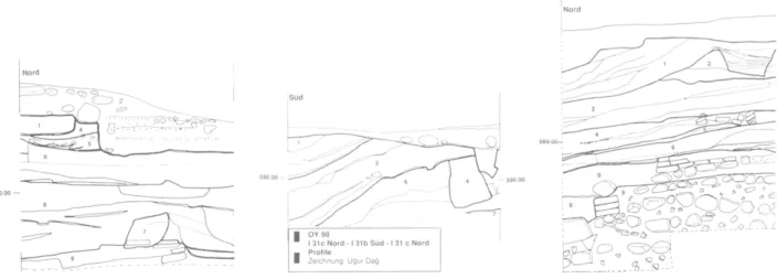
2.5. Relating the three trenches and peri- odization
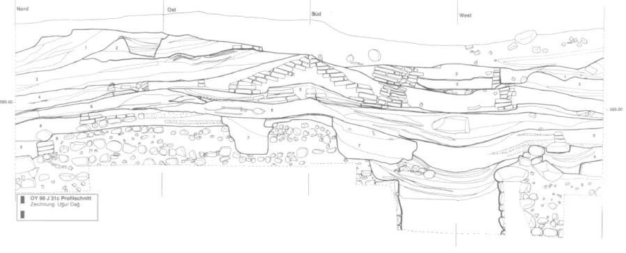
A tentative correlation and periodization of the stratigraphies from the three individual trenches will now be provided (See Abb. 14 for sections of J 31c ; Abb. 15 for sections of I 31c ; Abb. 16 for correlation of sections along East- West-axis) . The correlations between the trenches have been summarised in table 1. This framework serves as a stratigraphical background for the analyses of the ceramics and other finds (see below). The
correlations have been made on the basis of the slope of the deposits, the soil colour and texture, and a comparison of the available structures and features. Additional evidence and a firmer periodization will eventually be provided by the detailed analysis of the ceramics, of which a preliminary impression is currently available. On the basis of this preliminary analysis, it appears that two main periods are attested, which have been termed LCh 1 and LCh 2 (see below, section on the ceramics).
The earliest strata of trench J-31c cannot be related to the other two trenches. The exact relative date of the earliest feature excavated thus far, the monumental platform structure, is problematic. It was most likely constructed during the LCh 1 period, on the basis of a terminus ante quern provided by the strata that cover it and by the occasional Coba bowls found within the fill. It is stressed again that the 'Ubaid period sherds used as part of the fill within the structure do not provide a reliable date. A certain period of time may have taken place between the construction, use and demise of this platform and the next stratum 8. In terms of the ceramics, however, stratum 8 dates to the LCh 1 period as well (see below), and it may have been not much later in time than the stratum 9 platform. Following stratum 8 , strata 7 and 6 perhaps suggest
36 E. ÔZGEN, B. HELWING, A. ENGÎN, O. NIEWENHUYSE et R. SPOOR Features
Topsoil Pits
Terraced building? Red soil layer
Grey-brown soil layer Ovens Terraced buildings Soil layers with pits and burials
Dark-grey soil layer Domestic architecture Domestic architecture Domestic architecture Domestic architecture Soil layers with hearth Ditch Domestic architecture Monumental structure Periodization modern Late Chalcolithic 2 ? Late Chalcolithic 1 J-31c stratum 0 1 2 3 4 5 6 7 8 9 I-31b stratum 0 1 2 3 4 5 6 7 I-31c stratum 0 1 2 3 4 5 6 7 8 9
Table 1. Oylum Hoyiik, Western Trench. Stratigraphie correlation and periodization of the trenches 1997-1998.
a different use of this part of the mound than attested in stratum 8. From stratum 5 on, however, and in particular from stratum 4 until stratum 2, a strong continuity is suggested by a continuous rebuilding on the same general plan. This continuity is reflected in the Coba-bowl dominated pottery associated with these strata, which seems to be homogeneous, and which may be dated to the LCh 1 period.15 The upper-most strata of trench J-31c, strata 2 and 1 , finally, are correlated with the earliest strata excavated in trench 1-3 lb, strata 6 and 7. These strata are very similar in terms of soil colour and texture. The slope of the upper-most stratum 1 of trench J-3 1 c continues into stratum 6 of trench I- 31b. The pottery of strata 6 and 7 of trench 1-3 lb appears to be similar to that of trench J-31c.
Within trench 1-3 lb, strata 2, 3, 4 and 5 are correlated with strata 7 and 8 of trench 1-3 lc. The slope of the stratum 3 layers in trench 1-3 lb
continues into the stratum 8 layers of trench 1-3 lc. Both strata are similar in soil colour and texture. Moreover, similar features have been attested within these strata, consisting of a series of pits {strata 2 and 4 in 1-3 lb ; pit 53 in stratum 8 of 1-3 lc) and,
in particular, of burials {strata 5 and 7 of trenches I-31b and I-31c, respectively). It is likely that the burials from the two trenches belong to the same period of occupation. It is not impossible that they have been dug into LCh 1 deposits from LCh 2 surfaces represented by stratum 6 of trench 1-3 lc.16 However, the presence of these pits and burials, and the absence of architectural features suggests that for a certain period of time this part of the mound became used for activities situated some distance away from the associated buildings. Possibly these buildings were situated higher on the slopes of the mound, as is suggested by the sides of the Western Trench in which traces of well-preserved mud- brick walls can be observed. This might indicate a discontinuity in the occupation sequence between strata 5-2 of J-31c and the terraced building of I- 31c, stratum 6. A similar conclusion is suggested by the pottery sequence, which shows marked changes in terms of wares and vessel shapes (see below). Although it is as yet uncertain if these ceramic changes reflect a true break rather than a gradual transition from LCh 1 to LCh 2, the first option can certainly not be excluded at present. 15) In addition to Late Halaf sherds, the stratum 7 ditch also yielded some Coba bowl fragments.
16) This option is supported by the jar that had been used as part of burial 50. This jar seems to be part of the Late Chalcolithic 2 ceramic assemblage (B. Helwing and A. Engin, pers, comm.).
o r x Abb. 14 : Oylum Hôyiik 1997 - 98 : Areal J 31c Profilschnitt. Dag Abb. 15 : Oylum Hôyiik 1997 - 98 : Areal 1 31c Profilschnitt. ■-J