-f^\ ьл^· %Ш·^ ^'‘1Ύ Л г . С
’ w ^ 'W ii^· ¿ ' W · m L "'\^ ά Λ ? *·^ ί,« .Λ ν л Д м ■V«iv ^ t'«> •':4V,'É n ^ f «î ^' VÇ. «* ж я ÿ· ^■■».;?w *. 3t ^ ‘':p^‘
S-·- ■ ■·'.*«;.··.'·<* ‘-l · ;ν '■ '^ · *■, >·!·.*'“· · / ·^ · ' · · ^ . j; ! 'V ,.' ■ ·.."**' • ' ' ι · , · . · χ Ч*' :7V‘'i> ' W - ' , · ' .', 'Sj'.; ·■
Ü ^ ‘· it ч;,-·· чі ·/ -„irt ■ •ч»' -ί w w 4 Ь, ,ν Ч«« w '.;■ IC. іч.·;.» · <i к· *' ■- >■. *i” ;» i W f.i-wvi?*” ». ώ 'i,! ·»»*'■ .niW Iri^'i
·*' ψύ Л- ^ ^ .’Í fi' ·ίξ H*'“* « ’ •'Ip, · S*MÍ^ií«***í %i ύ 4hÚ«M( lí .4**' ЧІ '·*4 4·^ϋ, '4 ··--«: Μ T ·' ¡·ί :^ н 9 ^.N.4·, ·;·ίίΛ ; > 7í *1- 1-^ -■ *· ‘ -и r í' -гтЫ ^ -*. *. ^ ■' V. '* A j A f ■ T é S ( 3 S S Д ?/ !:> .f. ■'■■у vi.í ?.*■*· <*■■·, :'\;
THE CONTRIBUTION OF THE INTERNATIONAL COURT OF JUSTICE TO THE CONTINENTAL SHELF DISPUTES IN THE MEDITERRANEAN SEA
TFIE INSTITUTE OF ECONOMICS AND SOCIAL SCIENCES OF BILKENT UNIVERSITY
BY
AYSEM b ir iz t o k a t
A TFIESIS SUBMITTED TO THE DEPARTMENT OF INTERNATIONAL RELATIONS IN PARTIAL FULFILLMENT OF THE REQUIRENMENTS FOR
THE DEGREE OF MASTER OF INTERNATIONAL RELATIONS
BILKENT UNIVERSITY ANKARA
J X
w Λio^5
/ 9 9 e>
I certify that I have read this thesis and have found that it is fully adequate, in scope and in quality, as a thesis for the degree of Master of International Relations.
Prof. Santiago Martinez Caro
I certify that I have read this thesis and have found that it is fully adequate, in scope and in quality, as a thesis for the degree of Master of International Relations.
Asst. Prof. Gulgun Tuna
I certify that I have read this thesis and have found that it is fully adequate, in scope and in quality, as a thesis for the degree of Master of International Relations.
ABSTRACT
THE CONTRIBUTION OF THE INTERNATIONAL COURT OF JUSTICE TO THE CONTINENTAL SHELF DISPUTES IN THE MEDITRRANEAN SEA
Aysem Biiiz Tokat
M.A , Department of International Relations Supervisor: Prof. Santiago Martinez Caro
October 1999
In this thesis, after explaining the historical evolution of the concept of the continental shelf, It is tried to show how the International Court of Justice (ICJ) solved two continental shelf disputes - the Tunisia-Libya Case and the Aegean Sea Case - in the Mediten'anean Sea. Then, the other cases that deal with continental shelf delimitation and the jurisdiction of the International Court of Justice are take into account. The Mediterranean Sea is characteresed by the diversity in ethnic, cultural and political perceptions all of which become a reason for potential instabilities and crises. Therefore, the solution of the continental shelf disputes contribute to peace and security in the Mediterranean Sea, playing a crucial role in eliminating increasing tensions. In the conclusion, it is argued that the solution of the legal aspect is not sufficient. Because of the changing nature of the law on the subject and the inconsistency in the decisions of the International Court of Justice, a system of projects for joint development are suggested as a means for peaceful final solutions of the disputes.
ÖZET
ULUSLARARASI ADALET DİVANE NIN AKDENİZ’DEKİ KITA SAHANLIĞI ANALŞMAZLIKLARINA KATKISI
Aysem Biriz Tokat
Yüksek Lisans, Uluslar arası İlişkiler Bölümü Tez Yöneticisi: Prof. Santiago Martinez Caro
Ekim 1999
Bu tezde, kıta sahanlığı kavramının oluşumu anlattıktan sonra Uluslararası Adalet Divanı’m Akdeniz’de yer alan iki kıta sahanlığı anlaşmazlığının- Tunus-Libya Davası ve Ege Denizi Davası- nasıl çözümlediğini açıklanmıştır. Daha sonra, kıta sahanlığı ile ilgili diğer davaları ve Uluslararası Adalet Divam’mn kararlarını ele alındı. Akdeniz birbirinden farklı etnik, kültürel ve politik bir karaktere sahiptir ve bu yapı potansiyel dengesizlik ve krizler için bir neden oluşturmaktadır. Bu yüzden kıta sahanlığı anlaşmazlıklarının çözümü, Akdeniz’indeki barışa ve güvenliğe katkıda bulunur ve yükselen tansiyonun düşmesinde önemli bir rol alır. Bu konu ile ilgili hukukun değişen yapısı ve Uluslararası Adalet Divanı’nm kararlarındaki tutarsızlık yüzünden, ortak kalkınma projeleri sistemi bu anlaşmazlıkların barışçı çözümü için bir yol olarak önerilmiştir.
ACKNOWLEDGEMENTS
I owe a debt of gratitude to many people who helped make this thesis possible. Primarily, I would like to express thanks to Professor Santiago Martinez Caro for his patience, careful examination and useful comments.
I am also deeply grateful to Asst. Prof. Gülgün Tuna who initially motivated me and eased every hard minute for me by her academic discipline and problem-solving character. Ï am also thankful to Asst. Prof. Gülnur Aybet for her tolerance and kindness.
I want to express my special thanks to my mother, fiancée, sister, brother, whose efforts during my studies have been a major source of support.
TABLE OF CONTENTS
Abstract... i
Özet... ii
Acknowledgments... iii
Table of Contents... iv
List of Tables... vii
List of Maps... vii
INTRODUCTION... 1
CHAPTER 1: A HISTORICAL OUTLINE OF THE CONTINENTAL SHELF 1.1. EARLY REFERENCES TO THE CONTINENTAL SHELF... 5
1.2. THE GULF OF PARIA TREATY AND THE PRESIDENTAL PROCLAMATION... 9
1.2.1 THE GULF OF PARIA TREATY... 9
1.2.2. THE PRESIDENTAL PROCLAMATION... 10
1.3. THE GENEVA CONVENTION (1958)...14
1.4. THE NORTH SEA CONTINENTAL SHELF DISPUTE...19
1.5. UNITED NATIONS CONFERENCE ON LAW OF THE SEA III... 24
CHAPTER 2: THE CONTINENTAL SHELF DISPUTE BETWEEN TUNISIA AND LIBYA... 30
2.1. BACKGROUND... 30
2.2. PROCEEDINGS BEFORE THE COURT... ...38
2.2.1. TUNISIA...40
2.2.2. LIBYA...42
2.3. THE COURT...45
2.4. DECISION OF THE COURT... 49
CHAPTER 3: THE CONTINENTAL SHELF DISPUTE BETWEEN GREECE AND TURKEY... 54
3.1. BACKGROUND...54
3.2. PROCEEDINGS BEFORE THE COURT... 62
3.2.1. TURKEY AND GREECE...65
3.3. THE COURT... 68
3.4. DECISION OF THE COURT... 71
3.4.1. First Basis of the Jurisdiction: Article 17 of the General Act of 1928... 71
3.4.2. Second Basis of the Jurisdiction: Brussels Joint Communiqué of 31 May 1975..76
CHAPTER 4: OTHER DECISIONS... 76
4.1. NORTH SEA CONTINENTAL SHELF CASE...77
4.2. THE 1977 ANGLO-FRENCH ARBITRATION...79
4.3. AUSTRALIA AND NEW GUINEA NEGOTIATION... 82
4.4. LIBYA- MALTA CONTINENTAL SHELF CASE...8.5
CONCLUSION... 86
LEGAL ARGUMENT AS A SOLUTOIN... 86
JOINT DEVELOPMENT AS A SOLUTION... 87
APPENDICES... 89
Appendix A ORDER OF 11SEPTEMBER1976...89
Appendix B BERNE DECLARATION 11 NOVEMBER 1976...91
Appendix C SPECIAL AGREEMENT IN THE TUNISIA-LIBYA CASE...92
BIBLIOGRAPHY... 9.5
LIST OF TABLES
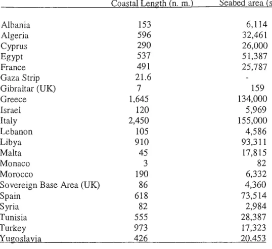
Table l.The Mediterranean coastline and seabed allocation...2
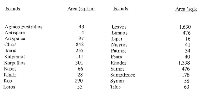
Table 2. The Greek Islands...54
LIST OF MAPS
Map 1. The Mediterranean Sea... 3Map 2. The agreed delimitation line in the North Sea Continental Shelf... 23
Map 3. The delimitation line between Italy and Tunisia... 32
Map 4. Alternative lines proposed by the parties...52
Map 5. The decision of the C ourt...53
Map 6. The Aegean Sea... 55
Map 7. The Anglo-French Arbitration... 82
INTRODUCTION
The concept of the continental shelf is one of the subjects of international law about which a great deal of literature is written. The practice of states, the work of the International Law Commission in 1950’s, the records of the 1958 Geneva Conference and the Third United Nations Conference are matched by the writings of several scholars and the decisions of the International Court of Justice. This is not only because of the importance of the subject to the international community but also because of the fact that the law on the subject changed very rapidly.
Therefore, analysing this concept under the light of the judgements of the International Court of Justice will shed hght not only on the state practice about the continental shelf but also on the legal attitude of such an international body. In other words, the concept of the continental shelf will be assessed by the decisions of the International Court of Justice, in order to examine the contribution of this Court to the continental shelf disputes among the states.
Essentially, as a consequence of this, two main purposes are tried to be achieved in this study. As a first step, the continental shelf disputes in the Mediterranean will be described in order to clarify the substance of those problems. The second step, then, will be the analyses of the decisions given by the International Court of Justice under the light of the legal developments and state practice.
with the continental shelf are particularly seen in enclosed and semi-closed seas. The physical disposition of coastal states and the geographical configuration of the enclosed and semi- enclosed seas make any change in the continental shelf especially difficult. The Mediterranean Sea has also the characteristics of the semi-enclosed seas.*
Comprising a long and a narrow corridor with a length of slightly over 2,000 nautical miles, this sea has a width under 600 n. m. at its widest point.^ Moreover, this limited area is divided between eighteen sovereign states as well as three dependent territories. The coasts of these littorals are very different from each other by length, configuration and direction.^
Table 1; Mediterranean coastlines and seabed allocation.
________________________ Coastal Length (n. m.~)_____ Seabed area Isq. n. m.)
Albania 153 6,114 Algeria 596 32,461 Cyprus 290 26,000 Egypt 537 51,387 France 491 25,787 Gaza Strip 21.6 -Gibraltar (UK) 7 159 Greece 1,645 134,000 Israel 120 5,969 Italy 2,450 155,000 Lebanon 105 4,586 Libya 910 93,311 Malta 45 17,815 Monaco 3 82 Morocco 190 6,332
Sovereign Base Area (UK) 86 4,360
Spain 618 73,514
Syria 82 2,984
Tunisia 555 28,387
Turkey 973 17,323
Yugoslavia 426 20.453
* Source: “Sovereignty of the Sea” , Geographic Bulletin 3
Map 1. The Mediterranean Sea.
* Source: http.www.expediamaps.com ‘ See Map Ion p.3
^ The widest point in the Mediterranean Sea is between the Strait o f Otranto and the Libyan coast as 600 n. m. ^ See, Table Ion p.2.
Map 1. The Mediterranean Sea. * Source; http.www.expediamaps.com ■ , M J ' § % . ; f - ' f L a f i s a ^ , I z m i r \ t IS v r n f S i ^ i ^ t R i A I ' *',.: .. .,' I'anlrwiAkaii' ; .■' '..k ^ ■:;...^a' . _ >
Furthermore, the presence of many islands with different size and location give to this sea one of its most distinctive characteristic/ In addition to those characteristics, sensitive and complex issues regarding to the political status and economic significance lead to many legal and diplomatic problems.
To begin with a short historical outline about the continental shelf will be necessary in order to concentrate on the purpose of this study. Then, two chapters will deal with two disputes in the Mediterranean taking into consideration the judgements of the International Court of Justice. The disputes related to the continental shelf are considered as follows: the case between Tunisia and Libya and then the Aegean Sea dispute between Turkey and Greece. The next chapter is based on other cases about the continental shelf delimitation and the jurisdiction of the International Court of Justice with respect to these cases. These cases-the
North Sea Continental Shelf Case, the Anglo-French Arbitration, Australia-New Guinea Negotiation, the Gulf of Main Case and the Libya-Malta Case- will provide sufficient clues
and evidences in order to assess the contribution of the Court. The final chapter will focus on the assessment of the contribution of the International Court of Justice.
Cyprus in the Eastern Mediterranean, Kerkennah Islands in the Central Mediterranean , Majorca in the Western Mediterranean are one of the examples.
CHAPTER 1
A HISTORICAL OUTLINE OF THE CONTINENTAL SHELF
1.1. EARLY REFERENCES TO THE CONTINENTAL SHELF
The history of the continental shelf (CS) goes back to the 1910 decree o f the
Portuguese Government. That decree explained CS as a habitat of fisheries. It also stated that
deep trawling by steam vessels beyond one hundred fathoms was extremely harmful to the fisheries. With this decree, fishing beyond one hundred fathoms was prohibited.^
Indeed, there was no clear definition of continental shelf in the 1910 decree of the Portuguese Government. This decree was a simple attempt in order to regulate the fisheries. The important point, however, is that the area over which the national jurisdiction was claimed, was beyond the territorial waters. In other words, this decree became the first intention to regulate the fisheries on the continental shelf.
In 1916, the second governmental attempt came from the Imperial Russian Government. The declaration of the Russian Government put forward that some of the islands were the integral part of the empire and formed the northern extension of the continental shelf of Siberia. However, this declaration did not deal with the submarine areas, whereas it was
^ The text o f this decree is reprinted in “UNITED NATIONS LEGISLATIVE SERIES, LAWS AND REGULATIONS ON THE REGIME OF THE HIGH SEAS, 1951” , vol. 1 , p. 19.
stated that the northern extension of the continental shelf of Siberia, in which there were several islands was part of the Russian territory.^
The following years were shaped by the writers and jurists, who tried to form the basis of the continental shelf doctrine. One of the most leading figures was the writer Storni from Ai'gentma. In his paper written in 1916, he insisted on the importance of continental shelf for commercial fishing.^ In 1918, Odon de Buen, from Spain, claimed that the national jurisdiction of the coastal state should extend to the continental shelf as a habitat of important
8 edible specifies of fish.
An event developed in 1918 in the Gulf of Mexico provided a change in the course of continental shelf history. Discovering a huge oil pool in that gulf, a United States citizen asked the Government of the United States to grand him a property or a leasehold right to a tract of the ocean bottom that contained oil. He also demanded protection, for the artificial island that would be built for the use of the oil. In his application to the United States Government, he additionally, stated that if he had permission for his demands then he would grant the oil field to the government- but in the light of an agreed consideration.
The US response to this situation was the statement that the US had no jurisdiction over the ocean bottom of the Gulf of the Mexico beyond the outer limits of the territorial waters. Therefore, the US did not grant the requested rights to the US applicant. But, the only idea was that if the island was built and given to the United States control, then the
* A. Gündüz, “Tlie Concept Of tlie Continental Shelf In Its Hi.storical Evolution” , Istanbul: Maimara University, (1 9 9 0 ), p. 17.
’ D. O’Connel, “ The Law o f tbe Sea ”. Oxford:Clarendon Press, (1 9 8 2 ), p.469.
* B. L. Austin, “The Continental Shelf. Tlie Practice and Policy of the Latin American States New YorkrOxford Press, (1961), p.42.
Department of State might provide protection. On the other hand, if the creation of the island did not lead to any attempts against the rights of the US citizens and no objection by a foreign government, then the Department of State would not oppose such an intention of creating an island.
Another event that shed light in continental shelf was the Ai'gentinean national
Suarez’s attempt in 1925. Being a member of League of Nations’ Committee of Experts for
the Progressive Codification of International Law, he suggested the extension of jurisdiction of the coastal state over the continental shelf with the aim of preserving and protecting the fisheries beyond the territorial water.'"’
Although Suarez’s proposal did not gain support, the idea he put forward remained as the constant policy among the Latin American States, until the acceptance of the exclusive economic zone. Again another Latin American writer Ruelas, for the first time in 1930 argued that the continental shelf had a natural prolongation of land territory and therefore belonged to the coastal state. In 1936, the theory founded by those Latin American writers gained a major support from the fishermen in the United States.
With the Japanese fishing fleets fishing salmon heavily in the Bristol Bay, Alaska, the US fishing industry reacted to those Japanese fisheries due to their overfishing. They saw these fishing fleets as a threat to their industry and therefore they protested against the Japan. As a result of these reactions, two bills were concluded.” The first one -the Diamond BiU- claimed that the sahnon in the rivers of the Alaska was the property of the United States.
^ See, “Reports o f Exploitations o f the Product of tlie Sea” in AJTL, Vol. 2, No.21, (1926), p.231. D. O ’Connel, “The International Law o f tlie Sea” Oxford:Clarendon Press , (1 9 8 2 ), p.469.
There would be a twelve-mile protection zone and an additional law enforcement area with a possible outer limit of 100-fathom line.'^
According to the other one, the Copeland Bill, the shallow depths of the Bering Sea must be regarded as a slightly submerged margin of the American Continent.’^ It aimed at the protection of the mineral deposits, fisheries, and animal life of the region. Additionally the extension of the Jurisdiction of the United States over the water and submerged land adjacent to the coast of Alaska was put on the table too. However, both of the bills were failed to pass through the Congress.14
J. W. Jessup, “The Pacific Fisheries” in AJIL Vol.33 , N o.l29, (1946). p.l81 Ibid.
‘‘‘ Tlie legal basis on which tlie bills were based were criticized by Jessup in his article “The Pacific Fisheries” in p.135.
1.2 THE GULF OF PARIA TREATY AND THE PRESIDENTIAL PROCLAMATION
1.2.1 GULF OF PARIA TREATY
The first treaty regulating the regime of the continental shelf was the Gulf of Paria
Treaty. It was concluded between the United Kingdom and Venezuela in 1942. The Gulf of
Paria Treaty is the first treaty that established and regulated the exclusive rights for the Parties in order to provide the possibility of exploration and exploitation of the submarine areas.
Defining the provisions and their respective interests in the submarine areas of the Gulf of Paria, both of the Parties had claims beyond the territorial waters. The Parties mutually recognised the high seas status of the overlying waters. It was decided that the navigation on the surface of the sea should not be changed due to any work or installation. Moreover, the Parties made further provisions for the protection of the environment against pollution, which might result from the explorations and exploitations.'^
Being a bilateral treaty, the Gulf of Paria Treaty was binding only the Parties concerned. Indeed, the area was not used for shipping purposes too much. Besides, the only coastal states were the parties themselves. On the other hand the treaty did not make any distinction between the seabed and the subsoil. It put them under the same regime. The treaty did not mention the term of “continental shelf’; they simply used the “submarine area of the Gulf of Paria”.
This Treaty was reproduced in “I UNITED NATIONS LEGISLATIVE SERIES, 44” , (1951)
For more details about the Treaty, see C. H. M. Waldock, “The Legal Basis of Claims to the Continental S h e lf’ in “The Grotious Society. Transactions for the Year 1948” Vol.36 ,N o .ll5 , (1950), pp.131-132.
But, interestingly, the United Kingdom formally annexed its submarine area to the Colony of Trinidad and Tobago, same as Venezuela that annexed its portion of the submarine area to its territory. On balance, the Gulf of Paria Treaty became important, because of the fact that it was the first treaty that obviously dealt with the continental shelf. On the other hand, with the annexations, it was also clear that the seabed and subsoil of the high sea could be taken over by occupation.
From 1910 to 1942, the continental shelf was either a habitat of the living resources where the coastal state(s) had rights or location of the minerals that could be exploited by the coastal state. Mainly, the continental shelf was seen as an area of physical nexus with the territory of the coastal state(s). But, the Gulf of Paria Treaty, although not being a declaration of the existing law, aimed at justifying their claims so that what they called the continental shelf would be recognised by themselves and by the other states.
1.2.2 PRESIDENTIAL PROCLAMATION (TRUMAN PROCLAMATION)
The emergence of the continental shelf as a legal Institution was the result of the change in the ocean policy of the United States. In the 1930s, President Roosevelt dealt with the extension of the US jurisdiction with the aim of protecting the Alaskan Salmon against foreign states, especially, against the Japanese fishermen. The US Government also aimed at maintaining its interests in that region. As a result preparations were made in order to establish the basis of the new policy. Because President Roosevelt died shortly before the proclamations became ready for issuance, it fell to his successor Harry Truman to issue them, on September 28, 1945.*^
A. Gündüz, “The Concept of tlie Continental Shelf in its Historical Evolution’’. Istanbul; Marmara University, (1990), p.24.
The Presidential Proclamation (Truman Proclamation) concerning continental shelf
contained two separate documents: one dealing with continental shelf, the other dealing with fisheries. On the document that focused on continental shelf, it was stated that there was a world-wide need for the resources of petroleum, gas and other minerals. According to the experts, on the other hand, these were available under many parts of the continental shelf off the coast of the United States.*** As a result, the proclamation argued that these oils and minerals could be used and therefore, over those regions, control and jurisdiction were needed. In the light of these facts, doubtless to say that the Truman Proclamation was built itself on a Just and reasonable ground.
According to that proclamation, close cooperation and protection from the coast should be obtained in order to provide the effective measures to utilize these resources. Moreover, the continental shelf might be considered as the extension of the landmass of the coastal state. Therefore, the resources in it -oil or other minerals- formed a seaward extension of the coastal state. As a result, the coastal state should not ignore self-protection and had to keep a close watch over activities on its coasts.
The United States, in this proclamation, put forward that the subsoil and the seabed of continental shelf belonged to the U.S. and were subject to its jurisdiction and control. The proclamation pointed out that where continental shelf bordered the coasts of other states(s), then the state(s) and the U.S. would determine the boundary according to the equitable principles. The proclamation itself did not define the outer limit of continental shelf. But, a press release issued simultaneously with the Proclamation defined the outer limit of
For further details about the Proclamation, see Presidential Proclamation, “No 2667 DEPARTMENT OF STATE BULLETTIN”, September 30 1945, pp.484-487.
continental shelf as no more than 100 fathoms (600 feet). 19
In the light of this statement, the area of continental shelf over which USA had jurisdiction became approximately 750.000 square miles. On balance, the United States acquired not sovereignty but Jurisdiction and control over that area. This proclamation, first of all, extended the jurisdiction of the coastal state over the resources of the continental shelf. Secondly, it introduced the ipso jure acquisition doctrine, which considered the continental shelf as natural prolongation of the land territory.
The Gulf of Paria Treaty opened the way for the positive law on continental shelf and was the first step; this Proclamation, finally, became the second step. After the Truman Declaration, many nations started to extend their jurisdiction to the seabed. Additionally, there were also cases of overlying waters beyond the territorial waters. The declarations that shaped the state practice, inter allia, took its essence from the Truman Proclamation."'’
Another conference was convoked with 19 states between 25-28 May 1956, in Ciudad Trujillo (Dominican Republic). The Ciudad Trujillo Conference led to the passage of a resolution on the legal status of submarine areas. As a consequence, continental shelf took the approval of most of the states. There was a general agreement on the extension of the national jurisdiction of the coastal state over the submarine areas beneath the high seas but contiguous to the coast, in other words over the continental shelf. However, the major problem came from the different definitions of continental shelf among the states.^’
See, “ UNITED NATIONS LEGISLATIVE SERIES, 39” , (1951).
Tlie practice of the Latin American .states like tlie Mexico Presidential Decree, tlie Pananumitm Regulations; tlie British practice like the Gulf of Parai Treaty; the practice of other states like tlie India prochunation.
The definition o f die condnental s h e lf: Scientifically, the term continental .shelf was understood to be diat portion of the continent or island which is covered by waters up to the point of declivity o f tiie slope or die edge o f the shelf.
In the view of some states, like USA, UK, Mexico, Brazil or Saudi Arabia, the seabed and subsoil of the submarine areas of the high seas beyond the territorial waters, but contiguous to the coast constituted the continental shelf. Therefore, the legal status of the superjacent waters was not changed. According to other states like, Chile, Peru, Costa Rica or Panama, the continental shelf included the submarine areas and also the waters covering them (epicontinental sea). As a result of this definition, these states extended their national jurisdiction both to non-living and living resources of their continental shelf.
Apart from the definition of continental shelf, another disagreement among states came Ifom the seaward limits of their continental shelves. Because, for some states, the outer limit of continental shelf was set up at the 200 meter (100-fathom) depth line, while some of the other states preferred a 200-mile distance limit.
Moreover, the degree of power that would be used over those areas created another disagreement. The US, Saudi Arabia or Mexico claimed only control and jurisdiction whereas Chile or Peru insisted on sovereignty. On the other hand Australia and India preferred the term of “sovereign rights”. Although there were disagreements about some points, the basic agreement was that the coastal state had the continental shelf rights and therefore third parities cold not make any claims over it.
1.3 THE GENEVA CONVENTION (1958)
When the ILC began to deal with continental shelf and included it in its lists of subject for codification, the first step for the Geneva Convention was completed. Slowly but surely, the Commission tried to develop and codify the legal regime of the continental shelf between 1950 and 1956. As a result, the International Law Commission proposed to the General Assembly to convoke a conference. The Conference was convened in Geneva, on February 24, 1958. The objects were to analyse the results of the work of the ILC about the Law of the Sea and to draft international conventions. The Geneva Conference consisted of four committees and the Fourth Committee dealt with the subject of continental shelf·'.
The Geneva Convention was the first conventional regulation of the regime of
continental shelf. It was signed on 29 April 1958 and came into force on 10 June 1964^^. Article 1 defined the continental shelf as:
a) the seabed and subsoil of the submarine areas adjacent to the coast but outside the area of the territorial sea, to a depth of 200 meters, or beyond that limit, to where the superjacent waters admits of the exploitation of the natural resources of the said areas.
b) the seabed and subsoil of similar submarine areas adjacent to the coasts of the islands.
There was a clear distinction between the legal definition and the geological definition. First of all, according to the geological definition, the continental shelf extends from the coastUne, whereas the legal continental shelf extends from the outer limit of the territorial
Tlie other conventions concluded by tlie Conference are: Convention on the Territorial Sea and the Contiguous Zone, in force 10 September 1964; Convention on Fishing and Conservation of the Living Resources of the High Sea, in force, 30 September1962.
The Convention is a relatively short document, consisting of 15 articles.
R. Platzoder, “The United Nations Convention on Law of the Sea Basic Documents witli an Introduction”, Dorthrecht: Martinus Nijhoff, (9 9 5 ), p.32.
waters. Secondly, for the outer limit of the legal shelf, there were two possibilities. It can extend to depth of 200 meters which meets the outer limit of the geological shelf. The other possibility for the outer limit, regarding to the legal definition, is the line, which would be determined due to the technological capacity to exploit the natural resources of the submarine areas. But, this do not match with the geological definition.
On the other hand, the nature and the extend of the rights of the coastal state were indicated in the Article 2;
1. The coastal state exercises over the continental shelf sovereign rights for the purpose of exploring it and exploiting its natural resources.
2. The rights referred in paragraph 1 to this Article are exclusive in the sense that if the coastal state does not explore the continental shelf or exploit its natural resources, no one may undertake these activities, or make a claim to the continental shelf, without the express consent of the coastal state.
3. The rights of the coastal state over the continental shelf do not depend on occupation, effective notional or on any express proclamation.^^
This Article, clearly, gives all rights to the coastal state(s) and excluded all potential claims of any third state. For the acquisition of the continental shelf rights occupation or any kind of proclamation were not necessary. They belonged ipso jure and ah initio to the coastal state. Article 4 paragraph 2 defined the natural resources that could be used by the coastal state:
4) The natural resources referred to in these Articles consist of the mineral and other non-living resources of the seabed and subsoil together with living organisms belonging to sedentary species, that is to say, organisms which, at the harvestable stage, either immobile on or under the seabed or unable to move except in constant physical
25
contact with the seabed or subsoil.
Article 6 ot this Convention dealt with inter-state delimitation in situations, where the states involved are either opposite or adjacent to each other. The Fourth Committee focused on the '‘special circumstances” clause rather than on the “equidistant line” in their discussions to formulate a general application for this topic. Although three states, Greece, Portugal and Yugoslavia, opposed the inclusion of this element, most of the delegations defended the Commission’s d ra ft.T h e y supported the “special circumstances” as being necessary for the effective application of the whole delimitation provision. Tunisia and Indonesia were one of the supporters.
The delegate of Tunisia stated “delimitation ...should take account of the geographical configuration of the region, and that considerable flexibility would have to be used in applying that Article”."* The delegate of Indonesia argued the “International Law Commission’ s text is sufficiently flexible to provide all states whatever their geographical situation with the necessary safeguard.S tatem ents of Iraq, UK, Italy, Sweden, USA and France were also in the same direction, that is to say, in agreement with the special circumstances.3 0
Article 6, as a result, was as follows:
26
1. Where the same continental shelf is adjacent to the territories of two or more states whose coasts are opposite each other, the boundary of the continental shelf appertaining to such states shall be determined by
agreement between them. In the absence of agreement and unless
Ib id ., p.33.
F. Alinish, “The International Law of Maritime Boundarie.s and the Practice of States in the Mediterranean Sea”. Oxford: Clarendon Press, (1993), p.55.
2S
30
Ibid. Ib id ., p.56 Ibid.
another boundary line is justified by special circumstances, the boundary line is the median line, every point of which is equidistant from the nearest point of the baselines from which the breadth of the territorial sea of each state is measured.
2. Where the same continental shelf is adjacent to the territories of two adjacent states, the boundary of the continental shelf shall be determined by application of the principle o f equidistance from the nearest point of the baselines from which the breadth of the territorial sea of each state is measured.^'
According to this Article, for two or more opposite or adjacent states sharing the same continuous continental shelf boundary, for the purpose of delimitation, agreement would be the first mean. If reaching an agreement is not possible or too difficult, then the second step would be shaped by the special circumstances -for instance, the presence of several islands- in the delimitation area in order to find out a negotiated line. However, if there is no special circumstances then the boundary line would be the median line in the case of opposite states and equidistant line in the case of adjacent states.
Although the Geneva Convention provided an important step for the legal definition of the continental shelf, some specific problems arising out of the interpretation of the Convention came also into the agenda. First of all, when the coastal state take measures for exploration and exploitation of the continental shelf, then the traditional high seas freedom and the right of laying and maintaining submarine cable or pipelines on the seabed of the high seas could be influenced. For example, the exploration of the continental shelf or exploitation of its resources might lead to interference with the navigation or fishing. In addition to this, the exploitation criterion is not defined in the Geneva Convention and that uncertainty results also to a different problems.
Secondly, the coastal state is allowed to construct, maintain or operate on the continental shell installations and other devices necessary for the continental shelf exploration and exploitation. Establishing safety zones and exercising jurisdiction are other opportunities that could be used by the coastal state. Those installations do not have any territorial waters and also do not have the status of island all of which could create different problems.
Finally, it is no longer as free for the international community to do research concerning the continental shelf as it had been before the Convention was concluded. Because, the consent of the coastal state is needed. But, if this research is a purely scientific one and deals with the physical or the biological characteristics of the continental shelf and if the request comes from a qualified institution, then the state shall not withhold its consent. Moreover, the coastal state is entitled to participate or to be represented in the research. At the end of the research, the results of the research should be published.
R. Platzoder, “The 1994 UNCLOS Basic Documents with an Introduction”, Dotxecht; Martinus Nijhoff, (1995), p.35.
1.4. THE NORTH SEA CONTINENTAL SHELF DISPUTE
The first and the most unportant case in which the International Court of Justice gave its opinion is the ''NORTH SEA CONTINENTAL SHELF CASE” of 1969. Generally speaking, this kind of cases have built on this case and on its interpretation. This case was based on the dispute about delimitation of the continental shelf concerning Federal Republic of Germany, Denmark and the Netherlands. With the request of the parties involved, the Court attempted to identify principles o f general equity applicable to the delimitation of the area under consideration. No question was raised as to the seawards limits of the shelf in the North Sea and the Court, therefore, had to deal with the dehmitation of the continental shelf areas in the said sea.
Both, Denmark and the Netherlands argued that the dehmitation should be concluded according to Article 6 of the Convention.^^ In their view, there was no "special circumstances” in the North Sea and therefore, their boundaries with the Federal Repubhc of Germany should be determined by the application of the equidistance method.^^ However, from the perspective of Germany, first of ail, Article 6 was not applicable, because Germany had not ratified the Convention of 1958, while Denmark and the Netherlands did.^'* Secondly, the rule of Article 6 did not become rule of customary international law.^^ Furthermore, Germany claimed that in any event, the rule could not be used, where it did not result in a just and equitable apportionment of the shelf. The Federal Republic, finally, emphasised the “special circumstances” existing in the North Sea. In other words, even if Article 6 became
See, North Sea Continental S h elf, (Federal Republic v. The Netherlands and Denmtirk), Judgement, IC J., Reports, (1969), para.37
” See, Submission No.3, Counter-Memorials of Denmark and The Netlierlands, in pleadings (1968), p. 221 See, Submission No.3 in the Memorial of the Federal Republic of Germ any, p.91
35 36
Ibid. Ibid.
customary law, then it again could not be applicable for this case, due to the special
circumstances.37
Under this main framework, the Court decided on the basis of customary international law but dealt with some aspects of the Geneva Convention as well. From the perspective of the Court, the continental shelf was the land territory, which was a ''natural prolongation’’ under the sea.^® Neither the International Law Commission nor the Geneva Convention used the concept of “natural prolongation” in their context. The Court itself introduced it into the vocabulary of the international Law of the Sea.
According to the Court, the continental shelf of a state included “a natural prolongation of its land territory into and under the sea” and the rights of the state “exists ipso
facto and ab initio, by virtue of its sovereignty over the land and as an extension of it”.^^ As a
result, the delunitation exercise of the Court would be shaped by the natural prolongation of each state under the sea. In other words, the determination of the extent of the underwater
platform that belonged to the states would form the processes of delimitation. In the
Judgement of North Sea Contiaental Shelf Case, the Court clearly stated the delimitation as follows:
“Delimitation is a process which involves estabhshing the boundaries of an area already, in principle, appertaining to the coastal State and not the determination de novo of such an area...The process of delimitation is essentially one of drawing a boundary line between areas which already appertain to one or other States effected.
” Ib id ., p.422.
See, North Sea Continental Shelf, Judgement, ICJ , Reports , (1969), para. 95. Ib id ., para. 19.
Indeed, this way of delimitation had only a declaratory character. It was not man-made or constitutive. As a result, the dehmitation became nothing more than noting the limits of the natural prolongation of each state. Moreover, this case showed that the analyses of the Court did not come from what should have been the interpretation of the whole rule of Article 6. Rather, the Court developed its view as part of the general principles of equity.
Moreover, Denmark and The Netherlands argued that the special circumstances could be taken into consideration only for cases, where a particular coastline, by reason of some exceptional feature, gave the state concerned an extend of continental shelf abnormally large in relation to the general configuration of its coasts.·*' Contrary to this argument, the Federal Repubhc claimed that the special circumstances clause did not constitute an exception to the rule of equidistance, but that these two elements were valid on an equal footing so that the equidistance element had no priority over the special circumstances element."*'
The Court, on the other hand, gave emphasis on the hierarchical order which was stated as follows:
Article 6 is so framed as to put second the obhgation to make use of the equidistance method, causing it to come after a primary obligation to effect delimitation by agreement. Such a primary obligation constitutes an unusual preface to what is claimed to be a potential general rule of law."*^
Although Article 6 could lead to different results due to the different geometrical construction of the varying cases, the strict version which provided a hierarchical order tried to be applied in the North Sea Continental Shelf dispute. Moreover, the Court overlooked the relationship between the equity and the special circumstances. In the Judgement, it was
See, the Danish and Netherlands Counter-Memorials, Pleadings, p.214-316 ‘‘‘ See, The Memorial of the Federal Republic o f Germany, Pleadings, p.43
explained as follows:
Delimitation is to be effected by agreement in accordance with
e q u ita b le p r i n c i p l e s , and taking account of a l l r e le v a n t c ir c u m s ta n c e s ,
in such a way as to leave as much as possible to each party all those parts of the continental shelf that constitute a natural prolongation of its land territory into and under the sea, without encroachment on the natural prolongation of the land territory.'*'*
The Court mixed what it cited as " a ll r e le v a n t c ir c u m s ta n c e s ’’ with the “special
circumstances” under Article 6. It is true that the relationship between the equity and the special circumstances as coordinate principles may not be precise from the language of the Article 6. Therefore the Court denied the norm-creating character of this Article.'*^
On balance, after the conclusion of the Geneva Convention, it became clear that it did not meet the expectations of the international community Although there was a great support for the concept of continental shelf among the member states of the Geneva Convention, the precision of the concepts was not obtained. The lack of clearness or double-criterion about the concepts like the depth and distance criteria, the exploitation criterion or outer limit were other important challenging factors. Besides, the rapid development in the maritime technology created an additional reason for different disagreements among the nations. All of these elements opened the way for the new meetings and arrangements about the Law of the Sea and in particular about the continental shelf.
See, North Sea Continental Shelf Case, Judgement, ICJ, Reports, (1969) p. 72 Ib id ., 93
45
Map 2. The agreed delimitation line in the North Sea Continental Shelf Case * Source: International Boundary Case, Cambridge: Grotius, p. 23
Line of delimitation agreed upon by treaty Equidistance line
1.5. THE UNITED NATIONS CONFERENCE ON LAW OF THE SEA (UNCLOS IH)
In 1967, Malta took the initiative and appealed to the General Assembly for revision or replacement of the Geneva Convention. The main purpose of that appeal was to clarify uncertainties about the limits of the national jurisdiction and the international regime. As a result of this attempt, the General Assembly established an Ad Hoc Committee in 1986. Then, it was replaced by the United Nations Seabed Committee aiming at preparing for the meeting of the Third United Nations Conference on Law of the Sea (UNCLOS III) which would be convoked in 1974.
In Montego Bay, the results of these efforts came as “The United Nations Conference on Law of the Sea” in 1982. Having a chapter about the continental shelf, this convention introduced a new concept, “the exclusive economic zone” (EEZ) into the field of international law. These improvements- UNCLOS III and EEZ- led to a change in the concept of the continental shelf In the Geneva Convention. In Article 55, EEZ was defined as follows:
The exclusive economic zone is an area beyond and adjacent to the territorial sea, subject to the specific legal regime established in this Part, under which the rights and jurisdiction of the coastal state and the rights and the freedoms of other states are governed by the relevant provision of the Convention.'^^
For the breadth of the EEZ, the convention claimed that it should not go beyond 200 nm from the baselines Ifom which the breadth of the territorial waters were measured (Article 57). The continental shelf, on the other hand, was defined as follows:
The continental shelf of a coastal state comprises the seabed and the
A. Gündüz, “The Concept of the Continental Shelf in its Historical Evolution”, Istanbul: Marmara University, (1990), p.205.
subsoil of the submarine areas that extend beyond its territorial sea throughout the natural prolongation of its land territory to the outer edge of the continental margin, or to a distance of 200 nautical miles from the baselines from which the breadth of the territorial sea is measured where the outer edge of the continental margin does not extend up to that distance/^
During the drafting period, the final provisions for the delimitation of continental shelf and EEZ resulted in clash of the two ideas. The first one “median line or equidistance
principle” was based on the proposal that the delimitation of both EEZ and continental shelf
should be effected by agreement using as a general principle, the median line or equidistance line in consideration with the special circumstances where this is justified. The second one was “equitable principles”. According to that principles, the delimitation should be effected by agreement in accordance with equitable principles taking into account all relevant cii'cumstances. Session after session. Article 83 (1) and Article 74 (l)came on the final stage during the Tenth Session.
In Article 83 (1) and Article 74 (1), as a first step, it referred to agreements in order to achieve equitable solutions for all sides in conformity with international law as stated in Article 38 of the Statute of the International Court of Justice. But, if there was no agreement, the Part XV that including provisions for the settlement of the dispute, should be taken into account.
Both articles made agreement the primary mean for a solution. However, they were not able in clarifying the substance of the agreement and therefore the parties involved faced with difficulties. In the North Sea Continental Shelf Case, the Court stated that “the delimitation must be subject of agreement between the states concerned.”'** According to this
Ib id ., p.206
statement, unilateral delimitation was rejected. Regarding this argument, the tribunal refused to “take into consideration a delimitation which did not result from negotiations or an equivalent act in accordance with international law”, in the Guinea- Guinea Bissau Arbitration. Within this context, the rules in Article 74 (1) and Article 83 (1) repeated the existing rules of conduct in all inter-state relations. Furthermore, these articles were based on the “good faith” and peaceful settlement of disputes”. However, these aspects too remained vague and open ended.
In the North Sea Case, the Court in defining “the obligation to negotiate meaningfully” referred to the cases of the Free Zones of Upper Savoy and the District of Gex and Railway
Traffic between Lithuania and Poland. And, it took as quotation that negotiation must be
pursued “as fast as possible with a view to concluding agreements”'''·^ In the Fisheries Jurisdiction Case, the Court emphasised that the most relevant method for resolving the dispute would be negotiation and to open the ways for negotiation. Because, according to the Court, the negotiation was therefore a proper exercise of the judicial function of the Court.·’''
The cases related to the continental shelf disputes were also faced with the equitable
principles, when agreement could not offer the proper solution for the cases. While these
cases tried to be assessed by the notion of equitable principles, no attempt was made to identify the content of those principles for the continental shelf disputes. In the Judgement of the North Sea Case, the Court put emphasis on equity. However, the Court never maintained that in all circumstances, the application of the equitable principles should lead to an equitable solution.
Ib id ., para. 87
In the Anglo-French Arbitration of 1977, the Court argued that equity was achieved through a method which would pay attention to geography. Because it held that “the appropriateness of the equidistance method or any other method for the purpose of effecting an equitable delimitation is a function or reflection of the geographical and other relevant circumstances of each particular case.”^* Unfortunately, the Tunisia-Libya Case went beyond the definitions of 1969 and 1977 cases. Because it said “the principles are subordinate to the goal. The equitableness of a principle must be assessed in the light of its usefulness for the purpose of arriving at an equitable result.”^^
Equity, as result of this statement , then became achieving a compromise between different claims. The Court, therefore, should select appropriate principles, that would lead to an equitable result. On the other hand, the Chamber in the Gulf of the Maine Judgement referred to equity as a fact-evaluation p ro c e s s .In the Libya-Malta Case, the emphasis was put on the equitable so lu tio n .B u t the term of equitable principles were not clear enough. It referred to the results to be achieved as well as to the means to be applied to reach that result. The Court then tried to identify some of the principles in order to reach to a conclusion. Geography- the inequalities of the nature, nonencroachment by one party on the natural prolongation of the other were one of these stated principles.
As a result, under the main framework of the developments on the Law of the Sea, stated above, the concept of continental shelf has experienced an historical evolution. After the Truman Proclamation of 1945, a certain amount of high seas was put under the control and jurisdiction of the coastal state for the purpose of exploitation and exploration of its
See, The Anglo-French Arbitration, (UK v. France), Decision o f 18 Mar. 1 9 7 8 , para. 97 See, The Tunisia-Libya Case, Judgement, ICJ Reports, (1982) para. 70
See, The Gulf of Maine Case, Judgement, ICJ Reports, (1984), para. 112 See, The Libya-Malta Case, Judgement, ICJ Reports, (1985), para. 28
natural resources. The Geneva Convention of 1958, on the other hand, could not stay alive any longer against the technological developments and unclear definition in its articles that led to controversy among the states. In the Third United Nations Conferences on Law of the Sea, the natural prolongation, the principle of equidistance and Exclusive Economic Zone were added into the Convention of 1982 (UNCLOS III). Within these developments, the coastal states gained
• the mineral resources of the seabed and subsoil of the submarine areas, • the fish swimming in it,
• the wind blowing over,
• the control and possession of the coastal state over the waters of the high seas within 200 miles of the coast.
Consequently, comparing the gain of the coastal state, it became clear that the loss of the international community that occurred so quietly made all of the developments a part of a peaceful revolution between the coastal states and the world oceans.
55
CHAPTER 2
THE CONTINENTAL SHELF DISPUTE BETWEEN TUNISIA AND LIBYA
(FEBRUARY 1982)
2.1. BACKGROUND
The present situation of the land frontier between Libya and Tunisia dates from 1910. Both countries had been under Turkish suzerainty since the middle of the 16'*' century. Proclaiming a French protectorate in 1881, the Tunisia Regency had not experienced any dispute with the “vilayet” of Tripoli about the frontiers or boundaries. Because, both of them were under the internal border of the Ottoman Empire.
In 1886 and 1892, some suggestions were proposed between France and the Ottomans with a view to a delimitation. The boundary, in those years, located in the middle of AL- Biban lagoon, at the mouth of the Wad Fessi. Later on, it was moved eastwards in the direction of the Wad Moqta, and led to the de facto establishment of the present site of Ras Ajdir. The new direction of this boundary was stated in the "Convention relative a la frontière
entre la régence de Tunis et le vilayet de Tripoli" which was concluded between the Bey of
Tunis and the Emperor of the Ottomans on 19 Mayl910.
This frontier established in 19 May 1910 remained unchanged, between the Regency of Tunis under French protectorate and the Itahan colony of Tripolitania after Turkey had
ceded that region to Italy. The decolonisation efforts of those years also did not result in a new arrangement of suggestion for the 1910 frontier. In other words, after their independence too, Tunisia and Libya respected the same convention with the same frontier.
It had moreover been expressly confirmed by “the Treaty o f Friendship and
Neighbourly Relations” concluded on 10 August 1955 between France (on behalf of Tunisia)
and Libya. On the other hand, Libya and Tunisia confirmed it implicitly by “the Treaty of
Fraternity and Neighbourly Relations” on 7 January 1957. This treaty was amended and
completed by “the Establishment Convention o f 14 June 1961” and expressly confirmed by an exchange of letters at the time of signing of that Establishment Convention.
Throughout the two World Wars, the convention was accepted and no dispute was seen about the 1910 frontier. Then, two treaties strengthened the validity of this convention. The first one was “the Cairo Resolution of the Organisation of African Unity” in 1964. The important principle in this treaty was that, "all Member States pledge themselves to respect the borders existing on their achievement of national independence”. The second treaty was
“the 1978 Vienna Convention on Succession o f States” which also accepted the same
principle. Thus the permanence and stability of the land frontier is one of the points where the Parties are in full agreement. No issue was raised by the Parties concerning its validity.
An incident occurring in 1913, when an Italian torpedo boat arrested three Greek fishing vessels in an area claimed by Tunisia gave Italy a reason in order to propose a delimitation line. It would be drawn between Libyan and Tunisian sponge-banks, in the dhection of the coastline at Ras Ajdir. Italy developed this delimitation line and it became formal in 1919,
with the issuance of “Instructions for the Surveillance o f Maritime Fishing in the waters of
Tnipolitania and Cyrenalca”. It provided that ;
"As far as the sea border between TripoHtania and Tunisia is concerned, it was agreed to adopt as a line of delimitation the line perpendicular to the coast at the border point, which is, in this case, the approximate bearing north-north-east from Ras Ajdir."^^
In order to avoid the danger of friction that might arise from the position of a foreign vessel near the frontier, the Itahan authorities established two eight-mile buffer zones at the two ends of the Libyan coast. With this zone, vessels flying foreign flags and not holding a license from the Italian authorities would be liable to be ordered away but not seized. Both Parties recognised that an important solution had been achieved with this buffer zone, which operated for a long time without incident and without protest from any side. The line was reaffirmed by the Italian authorities in Libya in 1931. After the independence of both countries, the situation existed in this respect.
On the other hand, Tunisia has concluded an agreement, dated 20 August 1971, with Italy. This agreement shaped the delimitation of the contmental shelf between the two country on a median-line basis. But special arrangements were put into effect for the Itahan islands of Lamplone, Lampedusa, Linosa and PanteUeria. So far as seawards limits are concerned, no delimitation agreement has been concluded by either Party with Malta.
See, Tunisia-Libya Continental Shelf Case, Judgement, ICJ, Reports, (1982), p.58. See Map 3 on p.32.
M a p 3. T h e d e lim ita tio n lin e betw een Ita ly and T u n is ia .
Neither Tunisia nor Libya had concluded any agreement delimiting any part of the continental shelf, or a certain area of their territorial sea. However, this did not prevent the activities of exploration and exploitation of the continental shelf. Each Party granted licenses or concessions in the continental shelf areas regarded by each Party as necessarily appertaining to itself. As a result of this, a considerable amount of drilling had taken place.
On the Libyan side, the legislative authorisation for this process was completed.^® It was only in 1968 that the first offshore concession was granted by Libya. Between 1968 and 1976, fifteen wells were drilled in an offshore concession area, several of which proved productive. In the meantime, Tunisia had granted its first offshore concession in 1964. In the concession granted in 1972, it was expressed that the concession boundary between Tunisia and Libya had to be bounded on the south-east direction. However, the position of this statement was not clear. In 1974, this boundary was specified as being a part of “the equidistance line ... determined in conformity with the principles of international law pending an agreement between Tunisia and Libya defining the limit of their respective jurisdictions over the continental shelf'.^®
In the same year Libya granted another concession. According to this, the western boundary was a line drawn from Ras Ajdir at some 26° to the meridian, that is to say, further west than the equidistance line. Consequently, the result was an overlapping of claims of each Party in an area some 50 miles from the coasts. Following protests in 1976 by each
Petroleum Law No. 25”, and “Petroleum Regulation N o .l” came into effect on 19 July
1955 and both of them were the legal essence of the arguments of Libya. See, Tunisia-Libya Continental Shelf Case, ICJ, Judgement, Reports, (1982), p.60.
Government, diplomatie discussions led to the signing of the “Special Agreement” on 10 June 1977. With this Special Agreement, it was decided to bring the matter before the Court. Even after the proceedings before the Court had begun, further activities by each Party led to protests by the other. The Court was requested to declare general principles and rules of international law which were applicable to the delimitation of the areas of continental shelf appertaining to Tunisia and Libya in the region concerned.^”
Flowever, apart from the licenses given for the purpose of exploitation and exploration, there has never been any agreement between Tunisia and Libya on the delimitation of the territorial sea, contiguous zones, exclusive economic zones, or the continental shelf, upon which the Parties formally agreed yet. This situation constituted one of the difficulties of the dispute between Tunisia and Libya, because the delimitation of the continental shelf should start from the outer limit of the territorial sea, in accordance with Article 1 of the 1958 Geneva Convention on the Continental Shelf.^^
Because of the absence of agreement signed about the continental shelf areas appertaining to the Parties, the 1910 Convention became an important feature for the consideration of the present case. Because it definitely established the land frontier between the two countries. Moreover, both Parties had the same view about the starting point which reinforced the significance of the place “Ras Ajdir”. As the starting point, Ras Ad jir had a crucial role in the present case. In addition to this factor, this area became important because, it was the point where the unilateral claims and certain partial maritime delimitation tried to be realised by the
All of tlie requests tliat were stated by tlie Parties will be described in a more detailed way in tlie following parts.
^‘Article 1; the continental shelf is referring a)to the seabed and subsoil of die submarine areas adjacent to the coast but outside die area of the territorial sea, to a depdi of 200metres, or beyond diat limit, to where die depdi o f die superjacent waters admits of the exploitation of die natural resources o f the said areas; b) to die seabed and subsoil o f similar submarine areas adjacent to die coasts of islands.
Parties. Apart from the concessions given by each Party for the purpose of exploitation and exploration, those claims too played a crucial role in the Tunisia-Libya Case concerning the continental shelf.
First of all, Tunisia claimed that the ZV (Zénith vertical) 45° line was drawn from the land frontier at Ras Ajdir, at an angle of 45° in a north-easterly direction. According to Tunisia, Article 62 of the “Instruction of the Director o f Public Works on the Navigation and
Sea Fisheries Department” (31 December 1904) did in fact define the areas of surveillance
for the llshing of sponges and octopuses, where the administrative authorities exercised exclusive power like control and regulations. At the first time, the ZV 45° was mentioned in
“the Decree o f 26 July 1951”, reorganising the “Legislation on Fishery Control” Article 3
(b) of which contained a spécifie reference to the line in the following terms:
"(b) From Ras Kaboudia to the Tripolitanian frontier, the sea area bounded by a line which, starting from the end of the 3-mile line described above, meets the 50-metre isobath on the parallel of Ras Kaboudia and follows that isobath as far as its intersection with a line drawn north-east from Ras Ajdir, ZV 45°."^^
However, the Tunisian ZV 45° north-eastern Rne could include a limited area for the specific fishery regulations and therefore had the nature of an unilateral claim. Besides, it was not a line plotted for the purpose of maritime delimitation.
Secondly, on the side of the Libyan claims, it was seen a northerly direction in conformity with the land boundary established by the 1910 Convention. This line was issued in the “Petroleum Law” (Law No.25 of 1955) on 21 April 1955. This was followed by