THE LAND OF BEAUTIFUL HORSES:
STABLES IN MIDDLE BYZANTINE SETTLEMENTS OF CAPPADOCIA
A Master’s Thesis
by
FİLİZ TÜTÜNCÜ
The Department of Archaeology and Art History
Bilkent University Ankara
THE LAND OF BEAUTIFUL HORSES:
STABLES IN MIDDLE BYZANTINE SETTLEMENTS OF CAPPADOCIA
The Institute of Economics and Social Sciences of
Bilkent University
by
FİLİZ TÜTÜNCÜ
In Partial Fulfillment of the Requirements for the Degree of
MASTER OF ARTS
in
THE DEPARTMENT OF
ARCHAEOLOGY AND HISTORY OF ART BILKENT UNIVERSITY
ANKARA
I certify that I have read this thesis and that it is fully adequate, in scope
and quality, as a thesis for the degree of Master of Arts in Archaeology and History of Art.
... Dr. Charles Gates
Supervisor
I certify that I have read this thesis and that it is fully adequate, in scope
and quality, as a thesis for the degree of Master of Arts in Archaeology and History of Art.
... Dr. Veronica G. Kalas
Examining Committee Member
I certify that I have read this thesis and that it is fully adequate, in scope
and quality, as a thesis for the degree of Master of Arts in Archaeology and History of Art.
... Dr. Paul E. Kimball
Examining Committee Member
Approval of the Institute of Economics and Social Sciences
... Prof.Dr. Erdal Erel Director
ABSTRACT
THE LAND OF BEAUTIFUL HORSES:
STABLES IN MIDDLE BYZANTINE SETTLEMENTS OF CAPPADOCIA
Tütüncü, Filiz
M.A, Department of Archaeology and History of Art Supervisor: Dr. Charles Gates
June 2008
The present work is a study on horses and horse breeding in Middle Byzantine Cappadocia with special attention being paid to the architectural evidence, namely, the stables. The major aim here is to test the hypothesis that the landowner magnates living in monumental rock-cut mansions bred horses in their large stables to supply their own troops, as well as those of the imperial army. In order to evaluate this further, this thesis investigates the stables of the elite mansions in three settlements, Açık Saray, Çanlı Kilise, and Selime-Yaprakhisar. The architecture of the stables is discussed along with their possible functions and meanings. Architectural data is supplemented by literary evidence on horses and horse breeding in the Byzantine world.
ÖZET
GÜZEL ATLAR DİYARI:
KAPADOKYA’DAKİ ORTA BİZANS YERLEŞİMLERİNDE YER ALAN AHIRLAR
Tütüncü, Filiz
Yüksek Lisans, Arkeoloji ve Sanat Tarihi Bölümü Tez Yöneticisi: Dr. Charles Gates
Haziran 2008
Bu çalışma Kapadokya’da Orta Bizans Dönemi yerleşimlerinde yer alan kayaya oyma ahırları incelemektedir. Burada temel amaç, Kapadokya’da bu dönemde ortaya çıkan zengin, toprak sahibi ailelerin, anıtsal evlerinin kayadan oyma ahırlarında askeri amaçlarla at yetiştirdikleri hipotezini test etmektir. Bu bağlamda, Açık Saray, Çanlı Kilise, and Selime-Yaprakhisar yerleşimlerinde yer alan ahırlar, bölgeden karşılaştırmalı örneklerle tartışılmıştır. Ahırların mimari özellikleri tarihsel kaynaklardan toplanan bilgiler ışığında değerlendirilmiş, bu ahırların işlevleri ve Bizans ordu teşkilatına olası katkıları sorgulanmştır.
ACKNOWLEDGEMENTS
First of all, I would like to express my special gratitude to my thesis advisor Dr. Charles Gates for his great patience, invaluable advice, and endless support. He has been a true sensei to me throughout my studies at Bilkent University, always kind and generous in giving me the courage I needed.
I am also grateful to the thesis committee members, Dr. Veronica Kalas and Dr. Paul Kimball for evaluating my work and providing valuable contributions. I am especially indebted to Dr. Kalas for sharing her expertise on the subject with me and introducing me not only to this topic but also to the “other” Cappadocia that I had not known of.
I also would like to express my warmest thanks to my instructors in the department: Doç. Dr. Marie-Henriette Gates, Doç. Dr. İlknur Özgen, Doç. Dr. Yaşar Ersoy, Dr. Jacques Morin, Dr. Thomas Zimmermann, Dr. Julian Bennett, and Ben Claasz Coockson. I learnt a lot from them.
I would like to thank to Dr. Oya Pancaroğlu for her advice and guidance in the formation process of my thesis.
I am grateful to my brother Mehmet for being a talented photographer, a skilled driver and great company during my trips; also to my cousin Bekir, who has provided insightful comments during our brain-storming sessions.
Words are inadequate for me to express my thanks to my dear friend Yağmur Sarıoğlu, not only for providing logistic support during my field trips but also for being my inspiration since the first day we met. She generously added her glitter and shine into the present work. I am also grateful to Nergiz Nazlar, who shared all my happiness and sorrow during my years at Bilkent. Aslıhan Gürbüzel also deserves special thanks for her precious suggestions and warm support. Thanks are also due to my friends Özgür Emre Işık and A. Burak Erbora, who worked hard as couriers bringing me the books I needed from the libraries of METU and Boğaziçi University. I also owe a debt of gratitude to my friends Müge Durusu and Mert Çatalbaş.
I also would like to thank the villagers of Selime, Avanos, Güzelyurt, and Göreme for their warm support, and also Sultan, the beautiful mare, for showing me why time spent with horses is never wasted.
I am also grateful to my family for their support and patience.
My deepest thanks are for Yurdal Çağlar, who was with me in every single step of my research project. This thesis could never have been completed without his encouragement, and is thus dedicated to him.
TABLE OF CONTENTS
ABSTRACT...iii ÖZET... iv ACKNOWLEDGEMENTS ... v TABLE OF CONTENTS...vii LIST OF FIGURES ... ix CHAPTER I INTRODUCTION... 1CHAPTER II THE SETTING ... 7
2.1 Which Cappadocia? ... 8
2.1.1 Etymology... 8
2.1.2 Geography... 10
2.1.3 History of Cappadocia ... 12
2.2 Middle Byzantine Cappadocia ... 17
2.2.1 Administrative and Military Organization... 18
2.2.2 Military Aristocrats of Cappadocia... 21
2.2.3 Roads and Towns in the Middle Byzantine Cappadocia ... 23
2.2.3.1 The Pilgrims’ Road ... 25
2.2.3.2 The Military Road... 25
2.2.3.3 The Pontus Euxenius-Tavium-Caesarea Road... 26
2.2.3.4 The Iconium-Koloneia-Caesarea Road... 26
2.2.3.5 Aksaray-Selime-Güzelyurt Road ... 27
2.2.4 The Byzantine Settlements at Açık Saray, Çanlı Kilise and Selime-Yaprakhisar ... 27
2.2.4.1 Açık Saray... 29
2.2.4.2 Çanlı Kilise ... 32
2.2.4.3 Selime-Yaprakhisar... 35
2.3 Conclusion ... 38
CHAPTER III THE LITERARY EVIDENCE: THE HISTORY OF HORSE BREEDING IN CAPPADOCIA AND THE HORSE IN THE BYZANTINE WORLD ... 40
3.1 Sources ... 41
3.2 The History of the “Cappadocian Horse” ... 43
3.3 Horses and Horse Breeding in Byzantium... 48
3.3.1 The Warhorse and the Byzantine Cavalry ... 49
3.3.2 Breeds and Supply of Horses ... 52
3.3.3 The Use of Horses in Transportation, Agriculture, Travel, and Leisure... 54
3.4 Conclusion ... 56
CHAPTER IV ARCHITECTURAL EVIDENCE: THE STABLES AND THEIR ARCHITECTURE ... 58
4.1 Approach to Research and Methodology... 60
4.2 The Catalogue ... 66
4.2.1 Açık Saray... 66
4.2.1.1 Stable of Açık Saray No. 2... 68
4.2.1.2 Stable of Açık Saray No. 2a... 69
4.2.1.3 Stable of Açık Saray No. 4... 70
4.2.1.4 Stable of Açık Saray No. 7... 71
4.2.2 Çanlı Kilise ... 72
4.2.2.1 Stable in Area I... 75
4.2.2.2 Stable in Area 10... 76 4.2.2.3 Stable in Area 14... 77 4.2.2.4 Stable in Area 15... 79 4.2.2.5 Stable in Area 20... 79 4.2.2.6 Possible Stables... 80 4.2.3 Selime... 81
4.2.3.1 Stables in Selime Kalesi... 82
4.2.3.2 Stable in Area 7... 84
4.2.4 Stables of Yusuf Koç Kilisesi ... 84
4.2.5 Stable of Pigeon House Church ... 85
4.3 Discussion ... 86 4.4 Conclusion ... 93 CHAPTER V... 97 CONCLUSION... 97 SELECT BIBLIOGRAPHY ... 101 FIGURES ... 114
LIST OF FIGURES
Fig. 1. The empire and the themata in the eighth century (Haldon 1999: Map IV). Fig. 2. The themata c. 920 (Haldon 1999: Map VII).
Fig. 3. The themata c. 1050 (Haldon 1999: Map VIII).
Fig. 4. Roads and communication lines in Anatolia (Haldon 1999: Map IV). Fig. 5. Map of Cappadocia: the roads and major sites identified by their Turkish names (Ousterhout 2005: Fig. 5).
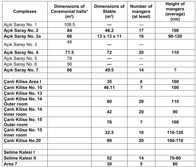
Fig. 6. The sites discussed in the text and their topography. Fig. 7. Site map of Açık Saray (Grishin 2002: Pl. 1).
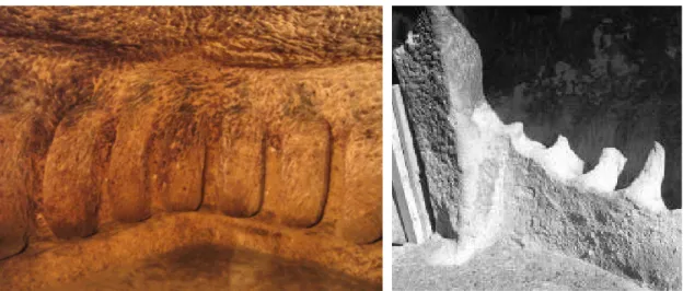
Fig. 8. Mangers for sheep and goats, height: 30 cm. Stable currently functioning in Selime.
Fig. 9. Stable in Kaymaklı Underground City (Photo by Ertan Turgut).
Fig. 10. Open-air mangers for sheep and goats adjacent to a rock-cut shelter that was once a component of a courtyard complex in Selime.
Fig. 11. Donkey manger, height: 30 cm. Selime Fig. 12. Donkey manger, height: 60 cm. Selime. Fig. 13. Manger for cattle, Height 65 cm. Selime. Fig. 14. Mangers for cattle. Height 40 cm. Selime.
Fig. 15. Stable for draught horses with mangers 80 cm high in Selime.
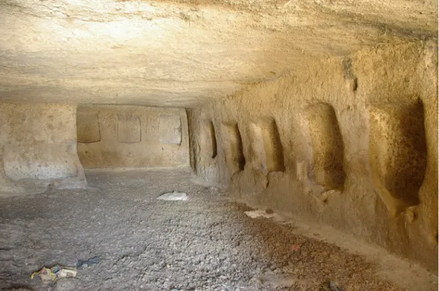
Fig. 16a. Stable housing saddle horses for leisure purposes. Mangers 90 cm high. Göreme.
Fig. 16b. Stable in Göreme. Fig. 16c. Stable in Göreme.
Fig. 17. Stable for draught horses in Selime that was once a bezirhane. Mangers 80 cm high.
Fig. 18. A multi-functional stable in Selime with diverse sized-mangers. Fig. 19. Plan of Açık Saray Nos. 2 and 2a (Rodley 1985: 126, Fig. 20).
Fig. 20. Açık Saray No. 2: Stable entrance from Room 7. Fig. 21. Interior of stable of Açık Saray No. 2.
Fig. 22a. Entrance of the stable of Açık Saray No. 2a and Room f top left. Fig. 22b. Entrance of the stable of Açık Saray No. 2a.
Fig. 23. Interior of the stable of Açık Saray No. 2a. View from the entrance towards the longest wall where the mangers are lined.
Fig. 24. Detail of mangers in the stable of Açık Saray No. 2a. The floor slopes towards the center to facilitate removal or droppings.
Fig. 25. View from inside the stable of Açık Saray No. 2a: The entrance and the small room on the north.
Fig. 26. Açık Saray No. 3 (Rodley 1985: 133, Fig. 21). Fig. 27. Mangers (?) in Room 6 of Açık Saray No. 3.
Fig. 28. Plan of Açık Saray No. 4 (Rodley 1985: 138, Fig. 22). Fig. 29. Entrance to the stable of Açık Saray No. 4.
Fig. 30. Interior of the stable of Açık Saray No. 4. Fig. 31. Detail of mangers in Açık Saray No. 4.
Fig. 32. Plan of Açık Saray No. 7. Adapted from Rodley (1985: 144, Fig. 25). Fig. 33. Façade of Complex No. 7 on the right, Room 3 projecting in the middle, the stable is entered from the low opening on the far left.
Fig. 34. Stable of Complex No. 7.
Fig. 35. Plan of Çanlı Kilise settlement (Ousterhout 2005: 295, Fig. 69). Fig. 36. Plan of Area I (Ousterhout 2005: 296, Fig. 70).
Fig. 37. Çanlı Kilise Area 1: Corridor Unit.
Fig. 38. Çanlı Kilise Area 1: View from inside the stable looking out. Fig. 39. Çanlı Kilise Area 1: Stable: The bench on the southwest wall. Fig. 40. Çanlı Kilise Area 1: Stable: The high mangers on the northeast wall. Fig. 41. Çanlı Kilise Area 1: Stable, removed mangers on the east corner. Fig. 42. Plan of Areas 10-14 (Ousterhout 2005: 298, Fig. 72).
Fig. 43. Stable in Area 10.
Fig. 44. Stable in Area 14. The exterior room on the front, leads to an inner one at the back.
Fig. 45. Detail from stable in Area 14: The mangers on the north wall of the large room on the exterior.
Fig. 47 The second room of the stable in Area 14. The third room is visible at the rear.
Fig. 48 Details from the mangers of the interior room. Fig. 49 Stable in Area 14a.
Fig. 50 Plan of Areas 15-16. (Ousterhout 2005: 299, Fig. 73). Fig. 51. Stable in Area 15.
Fig. 52. Detail from the stable in Area 15: Southern wall of the exterior room. Fig. 53. Detail from the stable in Area 15: North and east walls of the second room. Fig. 53a. Detail from the mangers in stable in Area 15.
Fig. 54. Plan of Areas 18-23 (Ousterhout 2005: 300, Fig. 74). Fig. 55. Stable in Area 20. West wall.
Fig. 56. Stable in Area 20. East wall.
Fig. 57. Plan of Area 13. (Ousterhout 2005: 371, Fig. 155). Fig. 58 The room identified as stable in Area 13.
Fig. 59. Plan of Selime Kalesi (Kalas 2006: Fig. 9). Fig. 60. Stable I in Selime Kalesi.
Fig. 61. Stable II in Selime Kalesi.
Fig. 62. Plan of Area 7 in Selime (Kalas 2000: Plate 61).
Fig. 63. Plan of Yusuf Koç Kilise Complex in Avcılar (Rodley 1985: 152, Fig. 28). Fig. 64. Stable I in Yusuf Koç Kilise Complex (Rodley 1985: 155, Fig. 147). Fig. 65. Stable II in Yusuf Koç Kilisesi Complex.
CHAPTER I
INTRODUCTION
Renowned since antiquity as the legendary “Land of The Beautiful Horses,” Cappadocia has been an important horse-breeding center throughout its history. The present work is a study on horses and horse breeding in this region in the tenth and eleventh centuries with special attention being paid to the architectural evidence, namely, the stables. The tenth and eleventh centuries are a period of change and revival in Byzantine history, in which Cappadocia played a vital role for the defense and expansion of Byzantium in the east. The provincial elite that emerged in the region during this time gained power and wealth through border defense. As possessors of great estates and large private troops, they held high positions in military and provincial administration (Vryonis 1971: 24-25). Recent studies have revealed that Cappadocia bears rich architectural evidence to illuminate this frontier environment during the tenth and eleventh centuries (Rodley 1985; Mathews and Mathews 1997; Kalas 2000; Ousterhout 2005).
The point of departure for the present study is a hypothesis put forward by V. Kalas, who asserts that the landowner families living in monumental rock-cut mansions bred horses in their large stables to supply their own troops, as well as those of the imperial army (Kalas 2000: 138). In order to evaluate this further and
shed light on the history of horse breeding in Byzantium with a focus on Cappadocia, this thesis aims to investigate the stables of the elite mansions within their broader archaeological and historical context.
The main source evidence for the present study is a series of rock-cut stables accompanying elite mansions in three settlements located in a volcanic area dominated by rock-cut settlements in the Aksaray and Nevşehir provinces: Açık Saray, Çanlı Kilise, and Selime-Yaprakhisar. Being the only published Byzantine settlements in the region, these three sites have yielded ample evidence about daily life and socio-economic dynamics of the Middle Byzantine society at Cappadocia. Each settlement contains several large stables furnished with various kinds of mangers. Although it is possible to use a standard manger for all types of large domestic animals, the systematic variation in the size and height of mangers seems to be an indicator of design for different species. The majority of the mangers are higher than 80 cm, affirming their function for tall animals such as horses. There is no question about the presence of other types of domestic livestock as also represented in architectural evidence; however this thesis focuses particularly on horse stables of the elite.
The scarcity of sources on horses and horse breeding in Byzantium necessitates blending the archaeological and textual data within the historical framework. Therefore, the archaeological evidence will be supplemented by textual data collected from military accounts, literary works, veterinary medicine books and chronicles, and the architectural-spatial analysis of the stables in turn will be interpreted in the light of textual evidence.
Of the five chapters presented here, following the introduction, Chapter II presents an overall discussion of the historical and geographical background of
Cappadocia with a focus on its frontier character during the Middle Byzantine period. It outlines the strategic importance of Cappadocia, a likely reason for the prominence of horse breeding in the region. Chapter III discusses the literary evidence on horses and horse breeding in Byzantium. After first dealing with the history of horse breeding tradition in Cappadocia across a long span of time, it surveys horses and horse breeding in the Middle Byzantine world with special emphasis on warhorses. Chapter IV investigates the rock-carved stables in the Middle Byzantine settlements of Açık Saray, Çanlı Kilise, and Selime, some of which have been published, others not. The stables will be described in a catalogue, with their possible functions and meanings discussed. Unpublished stables from various other contexts such as dwellings, churches and underground cities will be assessed briefly as comparanda. The final chapter will draw conclusions from the collected data and evaluate their implications for future studies.
Although the rock-cut architecture of Cappadocia has received considerable attention from art historians since the nineteenth century, their interest has mostly concentrated on religious art at the expense of the region’s secular art and archaeology (Kalas 2004a). The religious character of the wall paintings inspired an understanding of the region entirely in a monastic context. Intent on viewing their subject through the lens of religion, researchers in the field of Cappadocian studies have often overlooked other approaches with potentially greater explanatory power. This tradition has been challenged by recent discoveries that have generated a new understanding of Middle Byzantine settlements and domestic architecture. Studies by Lyn Rodley, Robert Ousterhout and Veronica Kalas have provided documentation of three sites, Açık Saray, Çanlı Kilise and Selime-Yaprakhisar (Rodley 1985; Ousterhout 2005; Kalas 2000), all of which contain private residences for the
provincial elite whose presence is attested in historical accounts. The most important contribution of these studies is their introduction of new subjects of study along with new research methods to the field.
The initial need for the documentation of monuments and associated wall paintings has been the major factor shaping research in Middle Byzantine Cappadocia. Thus, the literature largely consists of survey accounts and typological analyses of individual monuments, mostly examples of religious architecture.1 A drawback of this traditional approach is that it isolates buildings from their social and historical contexts, in effect, failing to contribute to our understanding of the Middle Byzantine frontier society. Necessary for a more accurate reconstruction of medieval Cappadocia, is a holistic approach and a broader perspective that would bring together different classes of data in a comparative manner. Since settlement archaeology is a recent field in the scholarship of Cappadocia, only certain architectural features, such as the layouts and façade decorations of the settlements have been discussed comparatively. The stables have been only briefly noted in the publications of the settlements. Some of them have been explored and documented for the first time in this study. The first scholar to draw attention to the stables has been Kalas (2000: 137-8), who has emphasized their potential value for Cappadocian studies; accordingly, this study follows the descriptions and terminology used by Rodley, Ousterhout and Kalas, aiming to build on their research.
The sources on which this project is built are problematic in a number of ways. First, the insufficiency of primary and secondary literature on horses and horse breeding in Byzantium has played the most restrictive role. The history of animal
1The classical reference source remains Jerphanion’s extensive catalogue of the monuments, Une
nouvelle province de l’art byzantin: Les églises rupestres de Cappadoce, which first articulated a
dating sequence. Later studies by Jean-Michel and Nicole Thierry, Catherine Jolivet-Levy and M. Restle have remained within the same methodological framework with a focus on the religious material and a concern for chronological problems.
breeding in Byzantium suffers from lack of scholarly interest and the rural aspect of Byzantine society has been inadequately explored. Therefore, subjects such as agrarian settlements and animal husbandry still await to be explored not only in Cappadocia but also in general throughout the empire. In addition, there is no other study of a similar subject with comparable material either in Cappadocia or in the entire Byzantine world; there are no sources in general on housing livestock in the ancient or medieval world and we know almost nothing about Byzantine stables. Such constraints have complicated the process of establishing a systematic methodology, but ultimately emphasize the importance of closely examining architectural details hitherto overlooked.
Horses were crucial and integral players in the Byzantine world. They were expensive and luxurious animals compared to other types of livestock. Thus, the presence of such large stables within residences indicates wealth, a measure of the elite status of their owners. By gaining a clear understanding of horses and horse breeding, we can provide a better-informed understanding of the Byzantine frontier society. Thanks to its rock-cut architecture that favors the exceptional preservation of features such as stables, Cappadocia provides ample evidence for this neglected field of study. Having remained in their original contexts with complete floor plans, elevations and in situ mangers, the stables of Cappadocia are rich sources of evidence for understanding horse breeding activities in Byzantium, as well as contributing to the interpretation of the true nature of the elite settlements.2 Hence, the present work is intended as an original contribution to the field of Byzantine archaeology and the history of the region by using the stables of Cappadocia as a testing ground for a general methodological approach, which can potentially be
2 The significant contribution of rock-cut architecture for reconstructing medieval Cappadocia has
applied to other features of Cappadocian architecture. By examining evidence for Cappadocian horses and horse-breeding aristocrats3, this research aims to enrich our knowledge of the socio-economic history of Cappadocia during the Middle Byzantine period.
3Although “aristocracy” is a controversial issue especially in the case of the provincial communities, I
employ the term for the high class that emerges during the tenth and eleventh centuries following the terminology used by such scholars as Magdalino (1984), Kalas (2000), and Ousterhout (2005).
CHAPTER II
THE SETTING
Cappadocia generally corresponds to the volcanic area extending over the provinces of Kayseri, Nevşehir, Aksaray and Niğde in modern day Turkey. Although this area always remained the core of the region, the latter’s exact boundaries varied over time, as summarized below. Here, the focus is on the tenth and eleventh centuries when the boundaries of the region were close to the modern limits. However, Cappadocia, as “the Land of the Beautiful Horses”, traditionally refers to a larger territory covering the majority of Central Anatolia. The primary aim of this chapter is to clarify the geographical and historical limitations of this thesis, while evaluating the changing borders of the region within the chronological framework. The first part of the chapter consists of an introductory section on the etymology, geography and history of the region while the second part focuses on the historical and physical setting of Middle Byzantine Cappadocia. Emphasis will be given to the settlements at Açık Saray, Çanlı Kilise and Selime-Yaprakhisar for a better understanding of their true nature as well as significance for the study of horse breeding in Byzantium.
2.1 Which Cappadocia?
2.1.1 Etymology
Since this study is mainly concerned with horse breeding in Byzantine Cappadocia, it would be useful to begin by questioning the origin of Cappadocia’s legendary title, “the Land of Beautiful Horses”. Although it is commonly assumed that the word “Cappadocia (καππαδοκία)” derives from the Persian word katpatuka, meaning “the land of beautiful horses” (Van Dam 2002: 65), the etymology is controversial.4
The earliest record of this name appears on an inscription carved on the cliffs of Mt. Bisitun (Behistun) in Persia listing the tribes and countries that Darius I conquered in late sixth century B.C. (Briant 2002: 172-75, 742). This trilingual inscription, in Old Persian, Elamite, and Akkadian, includes the Old Persian name
Katpatuka, a word claimed to mean “the Land of Beautiful Horses” (Schmitt 1980:
399-400; Ruge 1911). From then on, the name Cappadocia has remained constant, whatever the changing geographical limits of the region. The scholars usually agree that the name has derived from Katpatuka, but the meaning of the word is not clear (Baydur 1970: 114). As cited in Umar (1998), Herzfeld5 affirms its origin as
Katpatuka, linking katpat with “mule” and estimates that the suffix –uka derives
from the Armenian –ukh, used to produce nation names. However, to find an Armenian suffix in the middle of the first millennium B.C. is suggested to be
4 Van Dam (2002, 220) notes an alternative etymology by de Planhol (1981: 27-29), but I have not
been able to reach the source. (de Planhol, X. (1981). “La Cappadoce: formation et transformations d’un concept geographique,” Pp. 25-38 in Le aree omogenee della civiltà rupestrenell'ambito
dell'Impero Bizantino: la Cappadocia. ed. C. D. Fonseca. Galatina: Congedo Editore.)
5 The author does not mention the name or the date of publication; and the volume by Umar lacks
unlikely.6 Umar agrees with the use of the suffix -ukh, but seeks the origin of Katpat within Anatolia, connecting it to the Hurro-Hittite goddess Hepat/Khepat (Umar 1998: 2).7Besides, in questioning the legendary title regarding horses, Umar refers to the well-known Altiranisches Wörterbuch of Bartholomae and maintains that “fine horses” ccorrespond to huv-aspa, which has no apparent connection with either Cappadocia or Katpatuka.
Herodotus (V.49) lists the Cappadocians amongst the peoples in the army of Xerxes and affirms that their name (καππαδόκαι) was given to them by the Persians (Herodotus VII. 72), but does not refer to the origin of its name. Later in the Roman period, Strabo, describing the country extensively his Book XII, also fails to give any explanation on the etymology of Cappadocia., but another Roman historian, Pliny the Elder (VI. 3. 2), writes that the region was named after the Cappadox River (modern Delice Çay), the largest tributary of Kızılırmak. Thus “Cappadocia” meant “the land around Cappadox”.8
The last theory appears in the yearbook (salname) of Nevşehir published in 1914 by the Greek inhabitants of the city. Opposing both the legendary title about horses and the theory based on the Cappadox River, the author, Ioanis Georgiu, writes that the Assyrian King Ninias and Queen Semiramis had a son named “Kappadoks”, after whom the region has been named (Erdoğdu 1996: 51-52); it is also possible that this might be a mythical person invented by the Greek mythographers at a later period.9 Interesting to note is what appears to be an attempt on the part of the Greeks to link their origins with the great Mesopotamian
6 This is a suggestion by Prof. Gary Beckman, to whom I owe special gratitude to for his invaluable
help in assessing the theories on the etymology of Cappadocia.
7 Beckman does not find this theory convincing since no such country names deriving from the divine
name of Hepat appear neither in Hittite cuneiform or Hieroglyphic Luwian texts. G. Beckman 2008
pers. comm.
8 Beckman has pointed out that it is not clear which came first since the name of the river might have
also derived from Cappadocia. ibid.
civilizations and their legendary figures, which may have been a reflection of the trend in early twentieth century.
To summarize, the theories about the meaning of Cappadocia as “the land of beautiful horses” are ultimately unconvincing, and this legendary title appears to be more mythical rather than real, leaving the etymology of the word uncertain for the time being.
2.1.2 Geography
Cappadocia is the name of the large plateau at an altitude of approximately 1000 m in central Anatolia, extending from the Taurus Mountains in the south to the Kızılırmak (anc. Halys) River in the north, and from the Tuz Gölü (Salt Lake, anc. Tatta) in the west to the Mt. Erciyes (anc. Argaeus) in the east. The region lies on a rugged terrain rising gradually from west to east and is bordered by several volcanos, Mt. Hasan (3253 m), Mt. Erciyes (3916 m), Mts. Melendiz (2963 m) and Göllüdağ (2172 m). The succession of eruptions which began in the Miocene has lasted until the historical era, filling an area of 10,000 km² with volcanic ash, lava, and cinder. This was immediately followed by a process of erosion that still continues to shape the landscape, but with less intensity, creating a range of features in the landscape (Andolfato and Zucchi 1971: 51-60; Hild and Restle 1981: 47-61).
Although there are slight variations, the region generally has a continental and sub-desertic climate, which has changed little since the ancient and medieval times (Andolfato and Zucchi 1971: 51; Hild and Restle 1981: 56). Even though the precipitation levels are low, the three main catchment areas, that is, the Kızılırmak basin to the north, Melendiz Suyu to the southwest, and the Mavrucan basin to the southeast, drain the region with their numerous tributaries. The valley floors provide
favorable conditions for cultivating vines, orchards, and grain. Apart from these valleys, however, the land is generally arid in Cappadocia, as the volcanic soil is poor in organic content (Andolfato and Zucchi 1971: 51). This explains the great number of dovecotes hewn out of the rock for obtaining pigeon droppings, which is a fine quality fertilizer used in orchards and gardens (Gülyaz 2000: 552).
The vegetation pattern, depending on the altitude and the nature of the soil, mostly consists of steppe types with a small number of stunted trees (Andolfato and Zucchi 1971: 51), forests being confined to the slopes of the Erciyes Mountain. We learn from Strabo (XII.2.1) that it was not much different in antiquity. He writes that Cappadocia was poor in timber, which thus had to be obtained from the forests surrounding the Argaeus. He also describes the enormous plain as being mostly empty, with only few fruit trees between Mt. Argaeus and the Taurus range, while Melitene (Malatya), a city usually regarded as a part of Cappadocia, was rich in fruit trees.
The subsistence economy has been traditionally based on agriculture and stock raising. Despite the presence of urban centers since antiquity (e.g. Kayseri, anc. Mazaca-Caesarea; Kemerhisar, anc. Tyana; and Aksaray, anc. Koloneia), the region has been renowned for its agrarian character since ancient times (Semple 1922). Strabo (XII.2.10) describes Cappadocian land as excellent for growing fruit trees, and cultivating grain as well as for animal husbandry of all kinds. The large steppes of the region provided abundant grazing for horses and mules. Especially horses need succulent herbage, which is easily found in high level valleys or slopes of mountains. It is necessary to bear in mind that the vegetation patterns of Anatolia have considerably changed and deteriorated as a result of the modern exploitation of ancient and medieval forests. In ancient and medieval times, therefore, fodder may
have been much ampler and more varied than today. Also, with the introduction of modern technological tools in agriculture, the majority of the pastures have been converted into arable lands, thereby causing an overall neglect in animal husbandry.10 This change explains the lack of pastures in the region today. However, the slopes of Mt. Erciyes between 1800 and 3000 m are still covered by large pastures (Baydur 1970: 17).
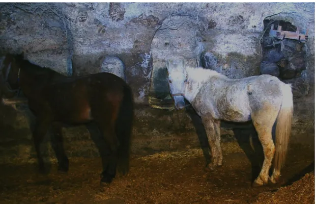
At this point, the hundreds of feral horses on the foothills of Mt. Erciyes are worth mentioning. These are free-roaming, untamed horses descended from domesticated horses that strayed, or were released into the wild. Despite being called “wild” horses popularly, they are not truly wild and can be re-domesticated quickly. Their presence, however, may be an indication that this area was the original habitat for the famous horses of Cappadocia. Nineteenth-century travelers also mention horse flocks wandering on the skirts of Mt. Argaeus (Texier 2002).
2.1.3 History of Cappadocia
The name Cappadocia has referred to different geographical regions in different times, with its constantly expanding and shrinking boundaries.11 Thus, the reputation of Cappadocian horses should not be credited to the core of the region. For a better understanding of the horse breeding tradition in the region, it is necessary to make a brief survey of its changing geographical identity from prehistory until the Middle Byzantine period.
The earliest trace of human habitation in Cappadocia dates back to the Paleolithic period (Esin 2000: 79). Intensive research has been conducted on the
10 Interview with villagers of Selime, Göreme, Avanos and Güzelyurt, February 2008.
11The historical geography of the region yet presents problems, although there have been valuable
Neolithic, Chalcolithic and the Bronze Age settlements, represented by several mounds such as Aşıklı Höyük, Alişar, Acemhöyük, and Köşkhöyük, most of which have yielded evidence attesting to continuous settlement until the Middle Ages (Esin 2000). In the excavations at Aşıklı Höyük, wild horse bones among other undomesticated breeds have been recovered, indicating the presence of wild horses in Anatolia at the beginning of the Holocene period (Esin 2000: 90).
In the earlier part of the second millennium B.C., the region was a commercial hub, with its center at Kültepe/Kaniš during the period of Assyrian trade colonies; in the second half of the second millennium B.C. it became a part of the Hittite Empire. After its collapse, the Kingdom of Tabal ruled the same territory surrounding Mazaca (Baydur 1970: 85-86). After the Kimmerian raids, the Land of Tabal was included in the Cilician Kingdom in 612 B.C. and was subsequently conquered by the Medes (Baydur 1970: 87; Briant 2002: 34-5). Herodotus reports that the Cappadocians were called “the Syrians” by the Greeks. According to the ancient writers, this was done in order to distinguish between the Syrians living to the north of the Taurus and those to the south; Greeks thus referred to the former as “the White Syrians (λευκοσυριοι) (Herodotus I.72, V.49, VII.72; Strabo XVI.1.2; Pliny VI.3). The changing borders of the region can also be traced from the accounts of the ancient writers. Herodotus (V.49) implies, for instance, that the Cappadocians lived east of the River Halys and were neighbors to the Paphlagonians, Phrygians, and Cilicians. However, his definition of the course of the Halys River implies that the upper part of the river ran through the Cilician lands (Herodotus, I. 72):
The boundary of the Median and Lydian empires was the river Halys; which flows from the Armenian mountains first through Cilicia and afterwards between the Matieni on the right and the Phrygians on the other hand; then passing these and flowing still northwards it separates the Cappadocian Syrians on the right from the Paphlagonians on the left. Thus the Halys river
cuts off wellnigh the whole of the lower part of Asia, from the Cyprian to the Euxine sea.12
Obscuring the border between Cappadocia and Cilicia, this statement suggests that Cappadocia was a part of Cilicia. Scholars agree that the borderline of Cappadocia before the Persians must have been retained during the Persian rule. Thus, Herodotus here must have referred to this earlier border of the Cilician Kingdom (Baydur 1970: 87). This appears plausible since the descriptions of Cappadocia’s borders elsewhere in Herodotus are inconsistent with this statement. Therefore, when he states that the Cilicians gave Darius a tribute of horses, he may have implied Cappadocian horses, as I will elaborate in the fourth chapter (Herodotus, III.90).
Strabo (XII.1.1), confirming the unclear limits of Cappadocia, writes that the country comprised many parts and had undergone many changes. He also reports that the Persians divided Cappadocia into two satrapies, one consisting of the central inland portion, named as Megale Cappadocia (the Greater Cappadocia), the other, the northern part up to the Black Sea coast, called Cappadocia Pontica (Strabo XII.1.4). However, his account is not considered reliable by modern historians who distrust Strabo’s references to the distant past as it was known to him (Briant 2002: 741). It should also be noted that evidence on satrapal Cappadocia is very scarce, obtained solely from lists of subject lands and imperial tribute schemes. The Persian rule in Cappadocia is mostly inferred from later sources, which do not necessarily reflect historical events accurately (Briant 2002: 742). Following the end of Persian rule, the two provinces remained separate, and so the name Cappadocia came to be restricted to the inland province. In the Hellenistic period, another independent kingdom, the
12 “Asia here refers to the western part of Asia, west of the Halys. The width from sea to sea of the
αύχήν is obviously much underestimated by Hdt., as also by later writers.” (Godley 1999: 89) (Text based on the 1920 translation by Godley).
Kingdom of Cappadocia, ruled over the region until the Romans took over power (Tekin 2000: 197-209).
Cappadocia became a Roman province during the reign of Tiberius, in A.D. 17 (Hild and Restle 1981: 64).13 Later, in 76 the two provinces of Galatia and Cappadocia were combined, and during the reign of Titus (79-81), Armenia Minor was incorporated into this double province, whose vast territory still called Cappadocia. Galatia was divided off in 117, and under Emperor Diocletian (284-305) Cappadocia was separated into two parts: the larger section on the west retained the name Cappadocia while the smaller part in the east was called Armenia Minor and later, Armenia Secunda. Emperor Valens (364-378) divided the province of Cappadocia as Cappadocia Prima and Cappadocia Secunda in c. 371. According to this last division, Caesarea remained the capital of the first one, while Tyana became the capital of the latter (Baydur 1970: 105; Hild and Restle 1981: 61-67; Tekin 2000: 199-225).
The Roman province of Cappadocia converted to Christianity very early. In the second century there were already several Christian communities in the region. In the fourth century, the Cappadocian Fathers, that is, Basil of Caesarea, his brother Gregory of Nyssa, and their friend Gregory of Nazianzos became influential figures for the development of the Orthodox monasticism. They participated in the political and ecclesiastical life serving as theologians and administrators at the same time (Hild and Restle 1981: 112-23). Their accounts provide rich information on fourth century Cappadocia and its considerable wealth (Foss 1991: 378; Akyürek 2000: 239).
13Our knowledge on Roman Cappadocia is primarily restricted to the textual evidence at present since
the material record from the Classical Cappadocia is limited to some funerary stelae and coins found in a few surveys (Equini Schneider 1994).
In the sixth and seventh centuries, the region was facing Persian invasions. In 629, Emperor Heraklios met the Persian general in Cappadocia to make peace upon terms for the withdrawal of the Persians from the eastern provinces of Byzantium (Kaegi 1992: 67), after which the Persians evacuated the Byzantine territories in Syria, Palestine, Egypt and Mesopotamia (Kaegi 1992: 73). This was immediately followed by the plundering expeditions of the Arabs (Haldon and Kennedy 1980). They besieged Constantinople in 674 and 678, and in 708, gained control of the Cilician Gates and Tyana, one of the most important defense points of Byzantium. Although they did not advance further to the north, their raids continued for two centuries (Hild and Restle 1981: 70-84).
As the Arab raids were going on the so-called theme system was introduced, which caused further alterations in Cappadocia’s borders (Whittow 1996: 117). A
theme is a strategic administration unit governed by a general, a strategos (Haldon
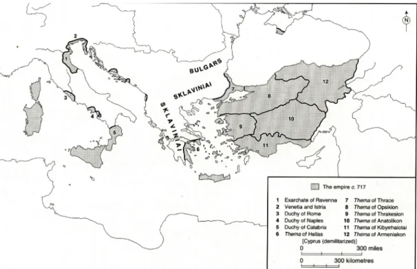
1999: 74), to be discussed in more detail in the second half of the chapter. Cappadocia until the ninth century was included in the borders of two themes, Anatolikon and Armeniakon (Fig. 1) (Whittow 1996: 120; Foss 1991: 378). Anatolikon was the most prosperous and the largest of all themes and its strategos received the highest salary (Vyronis 1971: 4). Emperor Leo III (r. 717-741), the former strategos of Anatolikon who found his way to the throne, was well aware of the power of the strategoi. Thus, he divided the theme into two in order to control them and also to avoid the possible danger of being dethroned by another strategos. The western half of Anatolikon was named Thrakesion theme (Fig. 2) (Ostrogorsky 1981: 146-7). In 752, as a result of the successful campaign of Konstantinos V in the east, cities of Theodosiopolis (Erzurum) and Melitene were taken back. In the early ninth century, two new themes, Charsianon and Cappadocia, emerged within
Anatolikon. The traditional name Cappadocia was kept for unofficial and ecclesiastical purposes, while in Byzantine administrative terminology, Cappadocia came to refer to a much smaller area on the south, extending from the Taurus to the Halys with its headquarters in Korone14, situated on the major routes used by the Arab invaders (Fig. 2). Peace was restored after the first half of the ninth century although Arab invasions continued until the Byzantines annexed Melitene in 934. Cappadocia, serving as a base camp where the troops gathered before going on campaign to the east, retained its strategic importance as a buffer zone between the Byzantine Empire and its neighbors throughout the Middle Byzantine period (Fig. 2) (Foss 1991: 378). The remainder of the chapter will discuss this frontier environment in Middle Byzantine Cappadocia.
2.2 Middle Byzantine Cappadocia15
This thesis focuses on a group of Middle Byzantine settlements, and their associated stables which yield evidence on horse breeding in the Byzantine world. Before moving on to the specific sites with rock-cut stables, first it is necessary to introduce their historical and physical context. The second part of the chapter therefore entails a discussion and description of Cappadocia’s administrative and military institutions, roads, towns and finally the three Middle Byzantine settlements in order to illustrate the overall background and the conditions suitable for a horse breeding tradition.
14 A Byzantine town located 32 km northwest of Niğde (Hild and Restle 1981: 216). The Turkish
name of the site is not known.
15 Here the Middle Byzantine period is taken to refer to the time between 867-1056, corresponding
2.2.1 Administrative and Military Organization
In the second half of the ninth century, the Byzantine Empire adopted an offensive strategy, a situation that necessitated changes, particularly in military organization (Whittow 1996: 181) that triggered important developments in the history of Cappadocia (Foss 1991: 378). A phenomenon that deserves a closer investigation for this particular study is the theme system since firstly, it constituted the main administrative and military organization of the time and secondly, gave way to the emergence of a military aristocracy in the border zones (Kazhdan and Constable 1982: 40; Whittow 1996: 337). Thus, although a somewhat controversial issue, the organization of themes is fundamental for the understanding of the military function of the Middle Byzantine elite in Cappadocia.
A theme is defined as “[…] a military division and […] a territorial unit administered by a strategos who combined both military and civil power.” (Kazhdan 1991f: 2034). The origin and evolution of the system have been key problems in the study of the Byzantine army organization, which also remains a subject of controversy.
The major questions have to do with establishing the date and the origin of the themata. Debates addressing this issue, starting in the 1950s, have polarized around two views. The traditional view, first advocated by Ostrogorsky, is based on the theory that Herakleios (610-641) created the theme system in the seventh century, whereas the second group of historians dates it to the following century (Haldon 1993). According to Ostrogorsky, the system was established for the upkeep of armies by settling the troops on the land, a solution found by the state for the problem of maintaining the cost of its armies during the financial crisis of the seventh century. The themata consisted of the so-called “farmer soldiers” who were
granted “military lands” (stratiotika ktemata) in return for military service (Ostrogorsky 1953). Haldon (1993: 20) defines the term “military lands” as “holdings of varying extent, held by a person who was entered in the military registers as owing military service hereditarily to the state, which service was supported in respect of basic equipment and, to a degree, provisions, from the income derived from the land.” These were administered by a strategos, whose major concern was supporting and reproducing the provincial armies in the most efficient way (Ostrogorsky 1953). Other historians such as Kaegi (1967), Hendy (1985), and Treadgold (1983) follow Ostrogorsky’s assumption. Despite the differences in their approaches, they generally agree on the theory that after the loss of Egypt and Syria, which were crucial food resources of the empire, the state settled soldiers on the land and supplied these territories with income, equipment, and provisions in order to recruit forces from them and support the armies (Teall 1971: 47; Kaegi 1967).
In contrast to the idea that the theme system was created by a single reform, the second view favors an “organic development” (Kazhdan 1991f: 2034-5). This theory, first advocated by Karayannopulos in late 1950s (Kazhdan 1991f), has been supported by Haldon, who opposes the traditional assumption that the upkeep of the soldiers was undertaken entirely by the state. Instead, he argues that there was no formal settling of soldiers by the state on such a massive scale because the state, in the financial crisis of the seventh century, would not give away its resources, for land meant tax, and tax meant money. Referring to the literary evidence from the eighth to tenth centuries, he asserts that the military service was hereditary and the soldiers mostly supplied their own equipment, mounts, and weapons (Haldon 1993).
Although the origin of the theme system is yet to be clarified, it is reasonable to conclude that the system derived from the military requirements across Anatolia, which also fulfilled civil administration tasks, although the priority was always given to military concerns and interests. It is this military aspect of the system that makes it important for the focus of the present on the thematic armies.
Although slightly different from century to century, each theme in general had an individual army of 4000-6000 troops consisting of heavy and light cavalry units, as well as infantry and archers (Teall 1971: 47). The cavalry formed the basis of these troops and was the most important unit of these armies (McGeer 1995: 211-217; 1991: 1114), as will be discussed in the fourth chapter. The thematic armies were local militia-like elements deployed on the frontier passes through which the enemy forces had to pass. These posts, exposed to enemy action, served a crucial role for the regaining of the eastern territories (Haldon 2003: 40). In The Book of
Ceremonies, Constantine VII writes about the camps and assembly points through
which the emperor passed on the way to Syrian or eastern frontiers where he was met by successive thematic armies (Constantine and Reiske 1829). As the imperial host approached a camp, the chief of the theme army was supposed to provide the emperor with anything he might need so that in addition to food and men, the themes also supplied horses and mules. Thus, the burden of furnishing the army fell upon the
themes (Teall 1959: 113-14; Constantine and Reiske 1829: 457, 477, 489 f.), which
was presumably the reason why the Cappadocian elite bred horses along with other pack animals in their large stables.
The earliest themes were fewer in number and larger in territory, whereas later they were divided into smaller units in order to weaken the power of their
the strategoi who benefited from the system, but also a number of families that were given estates by the emperor, as was the case in Cappadocia, especially during the reign of Nikephoros II Phokas (r. 963-969) (Kazhdan 1991a: 351). In return, they were expected to provide assistance for the empire against enemy raids (Levtchenko 1999: 145-159). In frontier areas like Cappadocia, the sudden attacks of the enemies necessitated prompt decision and action (Kazhdan and Constable 1982: 40). In time, they became involved in the political arena, causing changes in the rule and rebelling against imperial policies that threatened their power. The power and glory of such families lasted until the mid-eleventh century, when the system was abandoned (Kazhdan 1991f: 2035).
2.2.2 Military Aristocrats of Cappadocia
After the seventh-century crisis, the social elite was transformed into “new men”, who were selected as strategoi by the emperor on the basis of merit. In the eighth and ninth centuries, this class turned into an aristocracy (Haldon 2002: 24). In Middle Byzantine society, there were two types of aristocrats.16 The civil aristocrats held hereditary nobility and lived in cities whereas the military aristocrats gained status through military merit and lived in rural areas. The Taktika of Leo VI (886-912) advises that strategoi should be appointed on the basis of their military achievements rather than ancestry, as they fulfilled their duties better in order to compensate for their lowly birth (Bartusis 1991: 170). This caused a serious conflict between the civil and the military aristocracy.
The rural aristocracy that appeared in Cappadocia from the mid-ninth century onwards comprised land owning military magnates (Kaplan 1981). One of these
aristocratic families, the Phokas family, originally from Caesarea, produced several distinguished generals, including the Emperor Nikephoros II Phokas (r. 963-969), who had been strategos of the Anatolikon theme before he ascended to throne (Dennis 1988: 139). His policies gave many privileges to the rural landowners, gradually increasing their power and wealth (Cheynet 2006: I.24-5). During the tenth and in particular the eleventh century, these aristocrats grew entirely independent, thus posing a threat to the state (Haldon 2002: 24). Those in Cappadocia rebelled against Basil II (r. 976-1025), who, relocating Armenians in Cappadocia, appointed an Armenian strategos to the region, probably to break the authority of the Cappadocian magnates (Cheynet 2006: VIII.23).
A valuable document, the will of the protospatharius Eustathios Boilas from the year 1059, provides a detailed account of the estate of a large landowner in one of the eastern provinces. An officer originally from Cappadocia, his will states that for some reason he was forced to migrate from Cappadocia to a land at one and one-half week’s distance, where the people and the language were different. The evidence indicates that the estates of Boilas were located somewhere in eastern Asia Minor (Vryonis 1957). Another well-known aristocrat from Cappadocia for the same time period is Eustathios Maleinos, a cousin of Nikephoros II who gained his fortune when he was appointed the first strategos of the reconquered Antioch in 969 (Cheynet 2006: I.18, Kazhdan 1991d: 1478-79). He provided his enormously large estate for Basil II and his army during his campaigns against the Fatimids (Van Dam 2002: 66). However, upon learning that his estates extended for over seventy miles in the provinces of Charsianon and Cappadocia, Basil felt so threatened that he invited
him to the capital, whereupon he confiscated all his property, and kept him in a cage (Van Dam 2002: 66; Cheynet 2006: IV.31).17
The power and glory of the well-known Cappadocian families during the tenth and eleventh centuries is also reflected in the epic of Digenis Akritas, which is worth noting here also because it displays the geographical extent of Cappadocia, as exemplified by Digenis’ palace by the Euphrates (Mavrogordato 1956; Jeffreys 1998). Problematic as it may be to use the epic as a historical source, the story, as well as its setting, correlates with the historical circumstances of the time. It is possible to multiply such examples of great magnate families. This being said, available documentary evidence is confined to accounts relating to the Cappadocian aristocracy, and our knowledge about the remainder of the society is rather scarce. Concerning this point, further archaeological investigations should be illuminative.
2.2.3 Roads and Towns in the Middle Byzantine Cappadocia
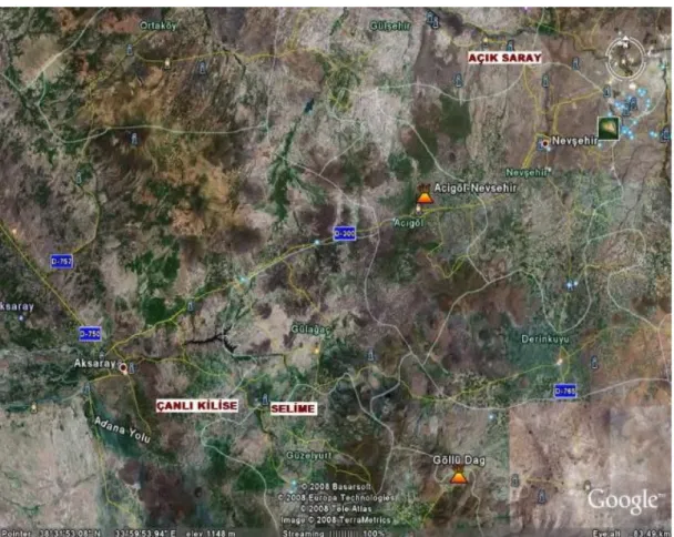
The three settlements analyzed here, Açık Saray, Çanlı Kilise and Selime-Yaprakhisar, are all located in the vicinity of major routes connecting the eastern border to the remainder of the empire (Figs. 4, 5). A brief survey of these roads and towns would allow the evaluation of these sites within their broader context with regard to their strategic importance.
During the Arab raids of the eighth and ninth centuries, the area that comprises the geographical scope of this thesis was exposed to constant invasions until the Byzantine Empire reconquered Cilicia and northern Syria in second half of the tenth century (Thierry 1963: iv). As previously mentioned, Arab invaders had
17 For further details on the estate of Eustathios Maleinos, see John Scylitzes, Synopsis historiarum,
ed. Thurn (1973) 340. For a distribution of magnates, see Hendy, (1985) 100-107; for the prominence of the Maleinos family, see Kaplan (1981) 143-52; and on its affiliations with the Phokas family see Cheynet (2006) I.18.
taken Tyana in 708 and established themselves north of the Taurus Mountains. The Byzantine defense system consisted of the natural fortification of the Hasan-Melendiz massif, supported in the rear by fortresses, one of which was probably the Akhisar castle and the fortification wall at Selime (Figs. 4, 5) (Kalas 2000: 156-9; Ousterhout 2005: 8-9, 182-3). Also, in the ninth century a special system was developed for rapid long-distance communication, which formed an essential part in the defense of the border. A court scholar, Leo the Philosopher, established a chain of hilltop towers for signaling over the large terrain extending from the Taurus Mountains to the imperial palace in Constantinople and covering a distance of around 720 km. Nine beacons were placed at intervals of 50 to 100 km, and messages were passed from each point to the next one, finally reaching the capital in an hour’s time (Fig. 4) (Pattenden 1983; Rautman 2006: 217).18 In the meantime, the garrisons at Rodenton (Anaşa Kalesi), Podantos (Pozantı) and Loulon (Ulukışla) were responsible for keeping the invaders at the Taurus foothills (Thierry 1963: iv). For the supply of reinforcement, the road network was renovated and new roads built from Caesarea to Tyana (Thierry 1963: iv). It is also important to note at this point that during the tenth and eleventh centuries Caesarea and Koloneia were amongst the most important a chain of aplekta, military staging posts, where the emperor met with the provincial divisions on his way to campaigns on the east (Hild and Restle 1981: 254-57).19
The Byzantine roads were of different standards for different purposes, and their rich terminology reflects the variety of road types. Sources mention both wide, paved roads, suitable for wagons, and narrow, unpaved roads or tracks (Kazhdan 1991e: 1798). From the seventh century onwards, the new emphasis placed on
18 On the Byzantine beacon system, see also Ramsay (1890: 187, 351-3).
military routes, along which fortified posts and military camps were established, reflects the state’s preoccupation with invasions (Haldon 1999: 53-60). The major Roman highways kept functioning throughout the medieval period and the roads below were already in use during the classical period (Ramsay 1890: 27-62; Baydur 1970: 19). Ramsay’s extensive monograph, The Historical Geography of Asia Minor (1890) remains the major source of reference for the geography of medieval Anatolia, and is still cited frequently in modern literature (Ramsay 1890) thanks to its reliable use of primary sources. Ramsay (1890: 74-82) provides a full account of the Byzantine roads and settlements with detailed reference to the historical events, with the discussion of Byzantine Cappadocia being focused on two major roads: the Pilgrims’ Road and the Military Road (Ramsay 1890: 197; 281-317).
2.2.3.1 The Pilgrims’ Road
The most important route in Anatolian peninsula of the medieval period, this road started from Constantinople, passed through Ancyra (Ankara), and from the east of the Salt Lake reached Koloneia (Aksaray) and then Tyana (Kemerhisar), eventually leading to the Cilician Gates (Gülek Boğazı). It was known as the “Pilgrims’ Road”, because it ended in Jerusalem (Ramsay 1890: 74-82). The modern highway that connects northwest Anatolia to the southeast follows the same route linking the major cities of Istanbul, Ankara, and Adana.
2.2.3.2 The Military Road
Longer but more practical and easier than the Pilgrims’ Road, the Military Road passed by Nikaia (İznik) and Dorylaion (Eskişehir) crossing the Sangarios
(Sakarya) by the bridge at Zompos (Zompe), and the Halys at what is today the Cesnir Köprü (Ramsay 1890: 220). It then forked east of the Halys, one route leading to Sebasteia (Sivas) and Armenia and the other to Caesarea (Kayseri) and Kommagene and to the Cilician Gates. The Military Road, which served almost for all the military expeditions to the east, was maintained with the utmost care until the eleventh century. There was a chain of aplekta situated at regular intervals for the service of the imperial army (Vryonis 1971: 31).
2.2.3.3 The Pontus Euxenius-Tavium-Caesarea Road
Starting from Sinope (Sinop) and Amisos (Samsun) on the Black Sea coast, this road passed through Amaseia (Amasya), Tavium (Büyük Nefesköy) and reached Caesarea, at which point it joined the roads leading to the Mediterranean coast, either via Tyana and Podantus or via Develi, Fraktin and Sisium (Kozan). The commercial importance of this route lay in the fact that it linked Cappadocia to the harbor towns on the Black Sea and the Mediterranean coasts (Sevin 2000: 52).
2.2.3.4 The Iconium-Koloneia-Caesarea Road
Similarly, this road was significant for linking Cappadocia to the cities on the Aegean coast. It extends from Iconium (Konya) to Koloneia (Aksaray) and Caesarea. Caesarea was at a major junction of roads, one of which led northeast towards Sebasteia (Sivas) and the other to Melitene via Elbistan. Teall (1959: 126) implies that good roads united Caesarea with the market towns surrounding it.
2.2.3.5 Aksaray-Selime-Güzelyurt Road
Archaeological evidence indicates that the route was already in use in the Roman period. The fortress on Gelin Tepe overlooking the Sivrihisar valley continued to function in the Byzantine period (Equini Schneider 1994). Although not one of the major routes, it bears relevance for the present study.
2.2.4 The Byzantine Settlements at Açık Saray, Çanlı Kilise and Selime-Yaprakhisar
Precise knowledge about the appearance and nature of Middle Byzantine settlements comes from three published sites: Açık Saray, Çanlı Kilise, and Selime-Yaprakhisar. All three incorporate stables, thus providing rich architectural evidence for the breeding of horses as well as other animals in Middle Byzantine Cappadocia. For a better-informed interpretation of these stables, first it is necessary to investigate the true nature of these settlements. The relevant discussion will draw predominantly from the works of Rodley, Ousterhout, and Kalas, and follow the descriptive terminology established by these authors for the above sites; room numbers for the architectural plans also follow the publications by Rodley, Ousterhout, and Kalas.
Given the predominant view of medieval Cappadocia as a region of intensive monastic activity, the traditional approach to these sites retains their initial identification as monasteries (Rott 1908; Jerphanion 1925). Recent studies by historians of architecture, however, challenge this assertion from the standpoint of settlement archaeology, a relatively new introduction to Cappadocian studies (Mathews and Mathews 1997; Ousterhout 1997; Kalas 2000). As a result, sites such as Çanlı Kilise, Selime, and Açık Saray have been interpreted as rural settlements rather than as monasteries, demonstrating that the complexes in question, previously
misidentified as monasteries, are in fact houses of the aforesaid military aristocrats.20 All of the stables discussed in this study accompany such elite complexes indicating the affluence of their owners.
A complex can be defined as a large housing unit with rooms arranged around a courtyard, most of which are ∏-shaped in Cappadocia, that is, a rectangular
courtyard with rooms on three sides (Mathews and Mathews 1997). Ousterhout (2005) terms each housing unit as an “area”; Kalas (2000: 75) following his terminology, defines an “area” as: “[...] architectural space that was once inhabited and is the equivalent of a dwelling however specifically defined, such as a habitation, architectural ensemble, unit, complex, manor house or mansion.”
The reinterpretation of the evidence from Açık Saray, Çanlı Kilise, and Selime in the context of Middle Byzantine domestic architecture is thus indicative of the elite status of their residents. It has been proposed that they accumulated this wealth through the historically attested border control besides farming and possibly horse breeding. According to Kalas (2000:138), the rural elite bred horses in their rock-cut stables to supply the imperial army as well as their own. The significance of horses in the medieval world, their economic value, as well as the reputation of Cappadocia as the Land of Beautiful Horses, strongly suggest that the magnates gained wealth through horse breeding. However, the role of horse breeding for the economy of Cappadocia should also be considered. For instance, what was the main purpose of breeding horses? Were they supplied to the army or used by the local landlords? Such questions are at the basis of this study, whose major objective is to form a more inclusive understanding of the nature of horse breeding in Cappadocia
20 For a critical survey of the history of scholarship in Cappadocia, see Kalas, 2000; and for a critique
of the traditional approaches to interpret Cappadocia as an entirely monastic region see Mathews and Mathews 1997; Ousterhout 1996, 1997; and Kalas 2004a.
in the tenth and eleventh centuries. Before analyzing the stables, which constitute the main class of evidence for this study, a survey of the three settlements is in order.
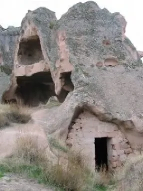
2.2.4.1 Açık Saray
The site known as Açık Saray (lit. “Open Palace” in Turkish) is located roughly 15 km northwest of Nevşehir (Figs. 5, 6); and 4 km from today’s Gülşehir, identified as Zoropassos in Byzantine documents, later changed to Arapsun, then to Yarapson (Hild-Restle 1981: 308; Ramsay 1890: 220). The history of this town goes back to antiquity. In Roman period, it was located within the limits of the province of Morimene, one of the ten strategeia mentioned by Strabo (XII. 1. 4), which extends along the south bank of the Halys from Galatia to Derinkuyu (anc. Melagop) (Hild and Restle 1981: 43-44). Zoropassos is named as one of the major towns in Morimene situated at an important point where the Halys narrows to allow easy crossing for travelers on the road leading to Hacıbektaş (anc. Doara), a bishopric from the fourth century and a significant centre known from historical sources whose exact location is yet unidentified (Ramsay 1890: 198), and from there to Kırşehir (Justinianopolis-Mokissos). The Military Road forked at Justinianopolis-Mokissos and one branch passed through Zoropassos, earning it significance especially during the Arab invasions (Ramsay, 1890: 220, 287). The medieval name of the settlement at Açık Saray is unknown. But being situated on an important road and in the setting of a fertile plateau watered by the Halys providing perfect conditions for agrarian activities as well as horse breeding, the area was no doubt much less isolated than it is today.
Lying on the western side of the modern Nevşehir-Gülşehir road, the site covers an area of approximately 1.5 km² (Fig. 7) (Grishin 2002: 164). The settlement
consists of several courtyard complexes carved into squat volcanic cones. The most recent survey at the site was conducted in 1985 by Rodley. Her monograph, Cave
Monasteries of Byzantine Cappadocia, represents the first attempt to fill the gap in
the study of Cappadocian architecture. She introduced a new approach into the scholarship by examining architectural features of Cappadocia from a broader perspective. Although her study does aim “to assemble the evidence for monasticism in the region and to establish its nature and chronology”, Rodley refrains from classifying Açık Saray as monastic given the paucity of churches, reserving a separate chapter for its discussion. Hers is the most comprehensive study of the site to date. This being said, the site awaits an overall accurate documentation and extensive critical investigation. The plans and orientations by Rodley are sketchy and inaccurate with lines consistently sharper and straighter than in reality causing confusions.21
In terms of function, many scholars believed that the complexes were monasteries (Rott 1908; Jerphanion 1925; Verzone 1962; Kostof 1989). Instead, it is much likelier that the Açık Saray complexes served as residences for the landowning aristocrats (Mathews and Mathews 1997), known from historical sources for gaining influence on the border zones at this time (Kazhdan and Epstein 1990: 63-65; Vryonis 1971: 24-25). The monastic funtion of the site was first challenged by Rodley, who proposed three possible alternatives for the interpretation of these complexes as 1) summer or hunting palaces used as temporary residences due to harsh winter conditions; 2) the Byzantine equivalent of Turkish hans for trade caravans (she took the Seljuk hans as models); 3) aplekta, military staging posts, each complex serving an army sub-division. Convinced that aplekta were placed on a
21 A critical discussion of Rodley’s contribution can be found in Mathews and Mathews (1997) and