See discussions, stats, and author profiles for this publication at: https://www.researchgate.net/publication/287799590
New Neolithic cult centres and domestic settlements in the light of Urfa
Region Surveys
Article in Documenta Praehistorica · December 2015
DOI: 10.4312/dp.42.25 CITATION 1 READS 413 1 author:
Some of the authors of this publication are also working on these related projects: PPN Settlements in Urfa RegionView project
PPN UrfaView project Bahattin Çelik
Iğdır University
40 PUBLICATIONS 107 CITATIONS SEE PROFILE
Documenta Praehistorica XLII (2015)
New Neolithic cult centres and domestic settlements
in the light of Urfa Region Surveys
Bahattin Çelik
Department of Archaeology, University of Ardahan, Ardahan, TR [email protected]
Introduction
The important role played by the South-eastern Ana-tolia region in the emergence of precursor settle-ments and cult centres during the Pre-Pottery Neoli-thic Period is better comprehended every day as new settlements are discovered. The discovery of settle-ments such as Nevali Çori (Hauptmann 1993.37– 69; 1999.66–86), Göbekli Tepe (Beile-Bohn et al. 1998.5–78; Schmidt 2001.45–54; 2002.8–13; 2007. 115–129), Sanlıurfa-Yeni Mahalle (Çelik 2000a.4– 6; 2007.165–178; 2011a.139–164), Karahan Tepe (Çelik 2000b.6–8; 2011b.241–253), Sefer Tepe (Çe-lik 2006a.23–25; Güler et al. 2012.161–162, 168– 169), Hamzan Tepe (Çelik 2004.3–5; 2006b.222– 224; 2010.257–268), Taslı Tepe (Çelik et al. 2011.
225–236; Güler et al. 2013.292–293), I·nanlı Tepesi
(Güler et al. 2013.291–304), Kocanizam Tepesi (Gü-ler et al. 2012.160, 167–168), Basaran Höyük (Gü(Gü-ler et al. 2012.158–159, 165–166) and Herzo Tepe (Gü-ler et al. 2012.159–160, 166–167) as a result of sur-veys conducted in recent years particularly in the Urfa region constitutes the best evidence for this fact (Map 1).
It is believed that, at such settlements recently dis-covered in the Urfa region, especially the Neolithic societies adopted a predominantly hunter/gatherer way of life. Today, excavations of this period are being carried out only at Göbekli Tepe, Nevali Çori and Sanlıurfa-Yeni Mahalle. Other settlements in the region with identical characteristics, such as Ham-zan Tepe, Karahan Tepe, Sefer Tepe and Taslı Tepe, have not been excavated yet. The common feature of such settlements is the presence of T-shaped pil-lars, like at Göbekli Tepe and Nevali Çori. Finds that are either similar or the successors to such pillars were also unearthed in the Adıyaman (Hauptmann 2000.5–9; 2012.13–22) and Gaziantep (Bulgan, Çe-lik 2011.85–90; ÇeÇe-lik 2005.28–29) regions located on the western banks of the Euphrates, proving that the phenomenon was even more widespread than previously thought.
Nineteen Neolithic sites were examined as a result of the studies conducted in the Urfa region, at Kurt Te-pesi, Guhera Abid Mevkii, Selamet Kuzey Mevkii, Se-ABSTRACT – The present study concerns Neolithic period cult centres and settlements discovered re-cently during surface surveys in the central district of Urfa (Sanlıurfa) region in south-eastern Tur-key. The presence of T-shaped pillars was ascertained at Ayanlar Höyük and Kurt Tepesi cult sites. Other settlements are domestic settlements arranged around cult centre settlements. Some sites be-long to Pre Pottery Neolithic, and the others to Pottery Neolithic. They are believed to be coeval with Göbekli Tepe and Nevali Çori cult sites.
IZVLE∞EK – V ∏tudiji predstavljamo neolitska naselja in kultna sredi∏≠a, ki so bila nedavno odkrita med terenskimi pregledi v osrednjem delu regije Urfa (Sanlıurfa) v jugovzhodni Tur≠iji. Tako ime-novani T stebri so bili dokumentirani v kultnih sredi∏≠ih Ayanlar Höyük and Kurt Tepesi. Okoli sre-di∏≠ so bila odkrita obi≠ajna naselja, nekatera datirana v pred-kerami≠ni, druga v kerami≠ni neoli-tik. So≠asna so s kultnima sredi∏≠ema Göbekli Tepe in Nevali Çori.
KEY WORDS –Sanlıurfa; Pottery and Pre-Pottery Neolithic (PPN); cult buildings; round buildings; domestic buildings
Bahattin Çelik
lamet Kuzey Höyügü, Çam-çak Tepesi, Terzi Village Batı Mevkii, Sıluba Tepesi, Asagı Yazıcı Güney Mevkii, Mınzilit Feris, Mınzilit Hıleyil, Mınzilit I·sa, Karakus Kuzeybatı kii, Çillo Mevkii 1, Çillo Mev-kii 2, Domuzcurnu Tepesi, Ne-bi Tarlası, Ömer Altundag Tar-lası, Hasan Sırtı and Ayanlar Höyük, respectively. Among these sites, T-shaped pillars were discovered at Kurt Te-pesi. At Ayanlar Höyük, on the other hand, a pedestal piece of what are thought to be T-shaped pillars and a lion head used for cult purposes have been unearthed. Based on these finds, Ayanlar Höyük
is also thought to be a cult centre. Flintstone tools and ceramics with characteristics of the Neolithic have been found at other sites. Selamet Guhera Abid Mevkii is one of the interesting sites discovered, and is thought to be a large snare area designed for catch-ing animals durcatch-ing this period.
Kurt Tepesi
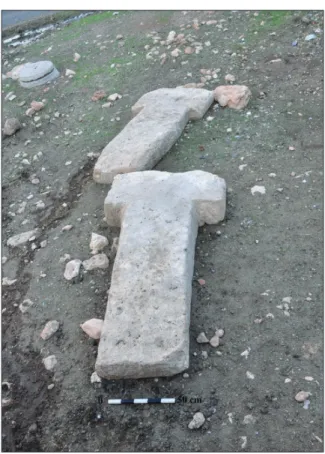
The mound, known locally as Kuça Gur, is located 45km east of Sanlıurfa province and 3km south of Sumaklı village (Map 1.1) at 730m above sea level (a.s.l.). It is located on a hill dominating Çoban De-resi Bogazı (Çoban Creek Pass), which functions as a passageway between the Harran plain and the Vi-ransehir region (Fig. 1). It is a small mound estab-lished on a ridge formed by high calcareous pla-teaus, which is very poor in terms of soil. Several sacked tumuli from the Roman period were located around this mound, covering an area of approx. 1ha. The mound is distorted due to illegal excavations; moreover, a high voltage transmission line pole is located at the north end Small cavern groups and pools carved into the bedrock were found in the cal-careous rocks surrounding the mound (Fig. 2). Nega-tive traces of a T-shaped pillar are apparent at an il-legal excavation pit in this area, which is thought to date to the Pre-Pottery Neolithic (Fig. 3). During the investigation conducted in the region, pillars which had been removed from their original site were di-scovered at Kösecik village, approx. 6km southeast of Kurt Tepesi (Fig. 4)11. Only flint and very scarce
obsidian finds were unearthed at the settlement; the finds include scrapers and drills and flint arrowhead fragments (Pl. 1.a–h). Moreover, stone beads, and pestle parts made from basalt stone were also dis-covered.
Guhera Abid Mevkii
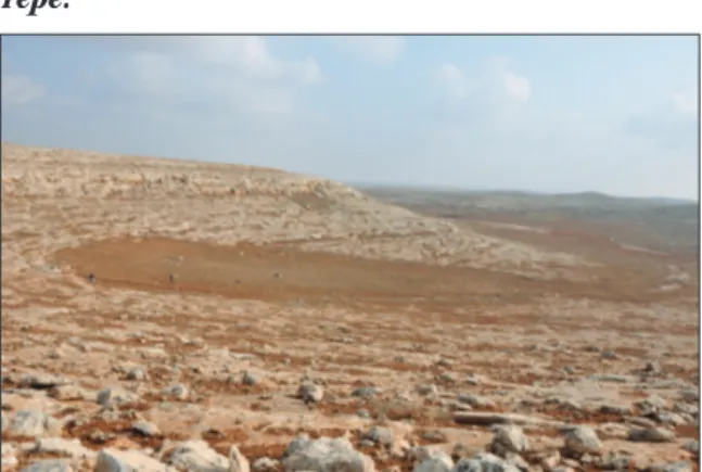
This site is located 48km east of Sanlıurfa and 500m northwest of Selamet village (Map 1.2) at 700m a.s.l. Two large trap sites for hunting wild game were di-scovered here (Bar-Oz on-line), laid out on the east-ern slope of a hill and extending to form a triangle starting from the hill towards the valley plain (Fig. 5). The trap site has walls made from large flag-stones, which are irregular and form a triangle with angles of approximately 50°. There are no wall rem-nants at the short edge of this triangle extending down from the hill. A wall remnant in the form of a circle of approx. 5m in diameter is present at the end of both converging long edges. Flint blades and flakes were discovered during the research in this area. Guhera Abid locality, where the traps are locat-ed, is approx. 3.5km southeast of the Kurt Tepesi settlement.
Selamet Kuzey Mevkii
This site is located 48km east of Sanlıurfa and 1 m north of Selamet village (Map 1.3). The settlement is on south-facing slope (Fig. 6) at 645m a.s.l., and covers approx. 0.5ha. Four tumuli were destroyed due to illegal excavations. Flint blades, flakes, and 1 The pillars were brought from Kuça Gura settlement by Hüseyin and Sinan Eyyüboglu, who live in Kösecik village. (Private
in-terview with I·brahim Eyyüboglu, 20.10.2013.) The pillars are now in the Sanlıurfa Museum.
New Neolithic cult centres and domestic settlements in the light of Urfa Region Surveys
Byblos and Nemrik type arrowheads were discover-ed during research in this area (Pl. 1.i–l).
Selamet Kuzey Höyügü
The mound, which is very small, extends over only approximately 0.2ha. It is located 1.5km north of Selamet village on a hill (Map 1.4) at 672m a.s.l. A remnant of a circular plan structure unearthed as a result of illegal excavations has been found here present (Fig. 7). Also, flint blades and flakes, as well as Babylos points and scrapers as fragments were discovered as a result of research. A Paleoli-thic open-air site was found 100m west of the settle-ment, where research yielded a Levallois core and points.
Çamçak Tepesi
This site is located 1km south of Kusharabesi vil-lage and 61km east of Sanlıurfa (Map 1.5), at 676m a.s.l. The site covers approx. 0.8ha. The settlement is situated on a calcareous hill (Fig. 8). Circular archi-tectural remains were unearthed by illegal excava-tions (Fig. 9). Blades, flakes, waste products and some point fragments were discovered by resear-chers. This site is approx. 7km northwest of the Se-fer Tepe settlement.
Terzi Batı Mevkii
This site, approx.1ha in area, is on a south-facing slope, approx. 1km west of Terzi village and 63km east of Sanlıurfa at 645m a.s.l. (Map 1.6). Research revealed that the settlement was inhabited during the Early Byzantine period, and the Chalcolithic and Neolithic period. Neolithic flint blades, flakes and point fragment were discovered at the site. This set-tlement site is approx. 6km northwest of Sefer Tepe. Sıluba Tepesi
This site is situated approx. 1.4km northeast of Yıl-dızlı village and 90km southeast of Sanlıurfa, at 522m a.s.l. (Map 1.7). Lying between two hills, the site is covering an area of approx. 2ha. It has an earth embankment approximately 1m high. During research at this site, a sacked tumulus from the Ro-man period was discovered on the western hill. The surface survey revealed flint flakes, blades and uni-polar cores (Pl. 1.m–r).
Asagı Yazıcı Güney Mevkii
This site, 1.2km southeast of Asagı Yazıcı village and 82km southeast of Sanlıurfa (Map 1.8), is covering an area of approx. 0.6ha, and is located at 56 m a.s.l. The settlement is on a slightly inclined crater area between two calcareous hills (Fig. 10), surrounded
by calcareous hills to the north, east and south, with only the section facing west being open. During the survey of this area, small ponds carved into the cal-careous rocks located east of the settlement were found; also, flint blades and flakes, some points and point fragments (Pl. 1.s–x), straw temper ceramics from the Pottery Neolithic period and ceramic frag-ments from later periods were discovered.
Mınzılıt Feris
This site is approx. 1.6km west of Altıntepe (Resmel-dehab) village, and located 77km southeast of San-lıurfa, situated at 612m a.s.l. (Map 1.9). The settle-ment is on a slightly inclined crater area between two calcareous hills and surrounded by calcareous hills to the north, east and west, with only the sec-tion facing south being open. The site is approxi-mately 0.1ha in area. The earth embankment of the settlement varies in height between approx. 50cm and 1m. No architectural remains were discovered here, but the survey yielded ceramics from the Neo-lithic, late ChalcoNeo-lithic, early Bronze and late Byzan-tine periods. Flint blades and flakes, some scraper fragments, and a very small amount of obsidian were also found (Pl. 2.a–f).
Mınzılıt Hıleyil
This site is located approx. 1.3km west of Altıntepe village, 77km southeast of Sanlıurfa and at an alti-tude of 596m a.s.l. (Map 1.10). The site, covering ap-prox. 0.5ha in area, is on a slightly inclined crater area between two calcareous hills (Fig. 11) and sur-rounded by calcareous hills to the north, east and west, with only the section facing south being open. No architectural remains were discovered at the set-tlement, as the area is currently in use as a field. The survey conducted here yielded ceramics from the Neolithic, late Chalcolithic, early Bronze, early By-zantine and Islamic periods. Moreover, flint blades, flakes, retouched blades, point fragments and scra-pers were found (Pl. 2.g–j).
Mınzılıt I·sa
This site is situated approx. 1km west of Altıntepe village and 77km southeast of Sanlıurfa, at 611m a.s.l. (Map 1.11). The settlement is on a slightly in-clined crater area between two calcareous hills (Fig. 12), surrounded by calcareous hills to the north, east and west, with the section facing south being open. The site covers an area of approx. 0.2ha. The earth embankment of the settlement varies in height between 1–2m. No architectural remains were disco-vered here, as the settlement area is currently in use as a field. As a result of the survey of this area,
ce-ramics from the Neolithic, Chalcolithic and early By-zantium periods were discovered. Moreover, flint blades and flakes made, some point fragments, scra-pers, drills and obsidian were discovered as small finds (Pl. 2.k–r).
Karakus Batı Mevkii
This site is located approx. 3km west of Karakus vil-lage and 70km southeast of Sanlıurfa, at 539m a.s.l. (Map 1.12). Lying on the slope of a stream bed fac-ing south, the settlement covers approx. 1.1ha (Fig. 13). A dry stream bed flowing east to west is locat-ed north of the settlement. No architectural remains were discovered here, as the settlement area is cur-rently in use as a field. As a result of the survey in this area, ceramics from early Byzantine periods as well as flint blades, flakes, end scraper fragments were discovered (Pl. 2.s–x).
Çillo Mevkii 1
This site is a hillside settlement located approx. 1km north of Çıralı village and 24km west of Sanlıurfa, at 668m a.s.l. (Map 1.13). The settlement is covering an area of approx. 0.5ha (Fig. 14). No architectural remains were discovered, as the area is currently in use as a field. The survey yielded ceramics from the Early and Mid-Byzantium and Neolithic periods (Pl. 3.g–k) and a flint bifacial tool from the Middle Pa-leolithic as well as abundant amounts of blades and flakes, unipolar cores and scrapers (Pl. 3.a–f). Çillo Mevkii 2
This is a hillside settlement located approx. 1.5km north of Çıralı village and 24km west of Sanlıurfa,
at approx. 658m a.s.l. (Map 1.14). The settlement is covering an area of approx. 0.5ha (Fig. 15). No archi-tectural remains were discovered, as the settlement area is currently in use as a field. As a result of the survey, ceramics from the Early Byzantine and Neo-lithic periods (Pl. 3.p–t) were discovered. Flint blades and flakes and scrapers and point fragments were also unearthed (Pl. 3.l–o).
Domuzcurnu Tepesi
This site is located 3.5km southeast of Kızılburç vil-lage and 28km west of Sanlıurfa, at 743m a.s.l. (Map 1.15). The settlement is covering an area of approx. 0.5ha (Fig. 16), lies on a low calcareous hill, and is surrounded by basalt deposits. It is a well-preserv-ed site, with traces of some walls visible. As a result of the surveys, flint blades, flakes, unipolar core, core replacement fragments and hammer and some point fragments, scraper fragments, drills and blade with sheen were discovered dating back to the Pre-Pottery Neolithic (Pl. 3.u–z). A very small amount of obsidian blade and flake parts were also found. Nebi Tarlası
This site is situated 2km southwest of Kızılburç vil-lage and 28km west of Sanlıurfa, at approx. 699m a.s.l. (Map 1.16). The settlement is covering an area of approx. 0.8ha. No architectural remains were di-scovered, as the settlement area is currently in use as a field. The survey yielded straw temper ceram-ics from the Neolithic and flint blades and flakes and scrapers were also discovered (Pl. 4.a–d). Also the usual amount of obsidian blades and flakes was also discovered.
Bahattin Çelik
Pl. 1. Finds from Kurt Tepesi (a–h), Selamet Kuzey Mevkii (i–l), Sıluba Tepesi (m–r) and Asag ı Yazıcı
New Neolithic cult centres and domestic settlements in the light of Urfa Region Surveys
Ömer Altundag Tarlası
This site is located 1km south of Kızılburç village and 28km west of Sanlıurfa, at 701m a.s.l. (Map 1.17). The settlement is covering an area of approx. 0.1ha, on the slope of a calcareous hill; basalt de-posits are available to the east. The settlement has been destroyed by agricultural activity. As a result of surveys, ceramics from the Neolithic and early Byzantium periods, and flint blades and flakes and core replacement fragments were discovered (Pl. 4.e–h).
Hasan Sırtı
This site is located 1km north of Kızılburç village and 28km west of Sanlıurfa (Map 1.18). The settle-ment is approx. 0.6ha in area at 752m a.s.l. (Fig. 17). The settlement is on the western slope of a calca-reous hill; basalt deposits are available to the east. The settlement was destroyed by agricultural activ-ity. As a result of the surveys, straw temper ceram-ics from the Neolithic period and Early Byzantine ceramics were discovered. Flint blade and flake frag-ments and scraper fragfrag-ments were also discovered (Pl. 4.i–l); a basalt stone upper grinding stone was also found.
Ayanlar Höyük
This site is located underneath and to the north of Ayanlar (Hut) village, 30km west of Sanlıurfa, at 733m a.s.l. (Map 1.19). It is covering an area of ap-prox. 14ha (Fig. 18). The mound, which was destroy-ed by agricultural activity, is around 10m high. The village settlement is located on the southern section of the mound, which comprises five hills. Basalt de-posits are available 2km to the east. The surveys re-vealed ceramics from the early and mid-Byzantine periods. Flint blades and flakes, unipolar and bipo-lar cores, core replacement fragments, scraper frag-ments, point fragfrag-ments, hammer and rested blade fragments were discovered (Pls. 4.m–v, 5.a–b). Very small amounts of obsidian blade and flake parts were also revealed. Lower and upper basalt grindstones, stone bowl fragments, stone plate and pestles were among the other finds (Pl. 5.c–g). Limestone cubes and pedestal fragments from hollow stone, which we know were made for pillars (Fig. 19) were also discovered during surveys in the village. Also, small pole groups carved into the bedrock (Fig. 20), which are familiar from Göbekli Tepe (Beile-Bohn 1998. Abb. 20), Karahan Tepe (Çelik 2011b.Fig. 5) and Hamzan Tepe (Çelik 2004.Figs. 2–3; 2006b.Figs. 3–
4; 2010.Figs. 6–8) were also discovered around the settlement.
Assessment and conclusion
Circular building architecture was unearthed at Se-lamet Kuzey Höyügü and Çamçak Tepe amongst the recently discovered sites. The remains of circular buildings were observed at Herzo Tepe (Güler et al.
2012.Fig. 4), I·nanlı Tepe (Güler et al. 2013. Fig. 8),
Hamzan Tepe (Çelik 2010.Figs. 3–4) and Sanlıurfa-Yeni Mahalle (Çelik 2000a.Fig. 3; 2007.162, Fig. 16; 2011a.142, Figs.14–16) during studies conduct-ed in the region in previous years. Both T-shapconduct-ed pil-lars and remains of circular buildings were encoun-tered at Hamzan Tepe (Çelik 2004.Fig. 4; 2006b. Fig. 5; 2010.Fig. 2.4). Likewise, a body piece of a T-shaped pillar as well as the remains of circular ar-chitectural buildings were also discovered at Yeni Mahalle (Çelik 2014.20, Fig. 21). The number of examples of this architectural tradition, which also resembles the circular cult buildings from Layers II and III of Göbekli Tepe, is gradually rising every day as a result of surface surveys (Schmidt 2010. Fig. 2). Examples of such buildings should date to the early stages of the Pre-Pottery Neolithic period. Similar buildings were also encountered at settle-ments such as Çayönü (Erim-Özdogan 2011.191– 193, Fig. 6.9), Hallan Çemi (Rosenberg 2011.61–63,
Figs. 2–6), Gusir Höyük (Karul 2011.2–4, Figs. 4–5. 11), Hasankeyf Höyük (Miyake 2013.40, 43, 46–47) and Körtik Tepe (Özkaya, Coskun 2011.90–93, Figs. 2–5).
The presence of T-shaped pillars is a feature com-mon to the Göbekli Tepe, Nevali Çori, Karahan Te-pe, Sefer TeTe-pe, Taslı TeTe-pe, Hamzan Tepe and Adıya-man Kilisik settlements. These pillars were also en-countered at Kurt Tepesi. One of the pillars unearth-ed at Kurt Tepesi has necktie-shapunearth-ed groove and chevron pattern relief (Fig. 21) that we recognise from Göbekli Tepe (Schmidt 2007.118, Fig. 11) and Nevali Çori (Hauptmann 1993.51–53, Abb. 16). The chevron pattern on the pillar at Kurt Tepesi is dis-tinct from the pattern on the pillars at Nevali Çori, as this pattern has a single strip. However, this pat-tern is similar to the single-strip patpat-tern on pillar 18 at the centre of building D in Göbekli Tepe (Schmidt 2010.Fig. 8). In particular, the T-shaped pillars un-earthed at Kurt Tepesi have several characteristics in common with Layer II of Göbekli Tepe and the cult building at Nevali Çori. Due to such similarities, Kurt Tepesi should be dated to the late PPPA and early PPNB.
Located approx. 10–15km southeast of Karahan Te-pe, the Mınzilit I·sa, Mınzilit Feris, Mınzilit Hıleyil and Asagı Yazıcı Güney Mevkii settlements present, due to their location, characteristics distinct from the
Pl. 3. Flintstone finds from Çillo Mevkii 1 (a–f), ceramic finds from Çillo Mevkii 1 (g–k), flintstone finds from Çillo Mevkii 2 (l–o), ceramic finds from Çillo Mevkii 2 (p–t) and Domuzcurnu Tepesi (u–z).
Neolithic settlements. The common feature of these settlements is that they are generally found on the southern slope of a rocky plateau and that they were inhabited in all periods. No architectural ele-ments were encountered, as agricultural activities are being conducted on the land where the settle-ments are located. The fact that such small-scale set-tlements are located in the vicinity of Karahan Tepe, and that such settlements contain no cult finds sug-gest they might have been domestic settlements af-filiated with Karahan Tepe cult centre.
Studies are being conducted at an area located ap-prox. 25km west of Sanlıurfa city centre in order to understand the discovery site of two artefacts from the Pre-Pottery Neolithic brought to Sanlıurfa Mu-seum in 2013 (Ercan, Çelik 2013.Figs. 1a–d, 3a–d). The studies conducted revealed that Ayanlar Höyük extends over an area of approx. 14ha. As a result of the research, the settlement was identified as a set-tlement inhabited during the Pre-Pottery Neolithic.
Furthermore, seven additional satellite settlements thought to be affiliated to this settlement were also discovered during the surface survey carried out south of the Ayanlar Höyük. Domuzcurnu Tepesi, Nebi Tarlası, Ömer Altundag Tarlası, Hasan Sırtı, Çil-lo Mevkii 1 and ÇilÇil-lo Mevkii 2 settlements, Çil-located at distances varying from 2–7km from Ayanlar Hö-yük. Finds from both the Pre-Pottery and Pottery Neolithic were unearthed at these settlements. These settlements are arranged in the form of a large tlement site at the centre with smaller domestic set-tlements arranged around it, as at Karahan Tepe and Kurt Tepesi.
Guhera Abid Mevkii was probably used for mass hunting and snaring of wild animals. The site is lo-cated approx. 3km southeast of the Selamet Kuzey Mevkii, Selamet Kuzey Höyügü and Kurt Tepesi set-tlements. This large snare area, the largest encoun-tered in the region so far, lies in a pass that sepa-rates the Harran Plain and Viransehir plain. This site
Pl. 4. Nebi Tarlası (a–d), Ömer Altundag Tarlası (e–h), Hasan Sırtı (i–l), Ayanlar Höyük (m–v).
Bar-Oz et al. on-line http://www.antiquity.ac.uk/projgall/ bar-oz319.htm.
Beıle-Bohn M., Gerber C., Morsch M. and Schmıdt K. 1998. Frühneolithische Forschungen in Obermesopotamien. Gö-bekli Tepe und Gürcütepe. Istanbuler Mitteilungen 48: 5–78.
Bulgan F., Çelik B. 2011. A New Statue From Gaziantep in Southeast Turkey. In H. Taskıran, M. Kartal, K. Özçelik and G. Kartal (eds.), Isın Yalçınkaya’ya Armagan Kitabı, Stu-dies in Honor of Isın Yalçınkaya. Bilgin Kültür Sanat Ya-yınları. Ankara: 85–90.
Çelik B. 2000a. An Early Neolithic Settlement in the Cen-ter of Sanlıurfa, Turkey. Neo-Lithics 2(3): 4–6.
2000b. A New Early-Neolithic Settlement: Karahan Tepe. Neo-Lithics 2(3): 6–8.
2004. A New Early-Neolithic Settlement: Hamzan Tepe. Neo-Lithics 2(04): 3–5.
2005. A New Statue of the Early Pre-Pottery Neolithic Period from Gaziantep. Southeastern Turkey. Neo-Li-thics 1–05: 28–29.
2006a. A New Pre-Pottery Neolithic Site in Southeastern Turkey: Sefer Tepe. Neo-Lithics 1(06): 23–25.
2006b. A New Lower Paleolithic Open Air Station and Early Neolithic Settlement. In A. Erkanal-Öktü, E. Öz-gen, S. Günel, A. T. Ökse, H. Hüryılmaz, H. Tekin, N. Çı-nardalı-Karaaslan, B. Uysal, F. A. Karaduman, A. Engin, R. Spiess, A. Aykurt, R. Tuncel, U. Deniz and A. Rennie (eds.), Hayat Erkanal’a Armagan, Kültürlerin Yansı-ması, Studies in Honor of Hayat Erkanal, Cultural Reflections. Homer Yayınları. Istanbul: 222–224. 2007. Sanlıurfa Yeni Mahalle – Balıklıgöl Höyügü. In M. Özdogan, N. Basgelen (eds.), Anadolu’da Uygarlı-gın Dogusu ve Avrupa’ya Yayılımı, Türkiye’de Neoli-tik Dönem, Yeni Kazılar, Yeni Bulgular. Arkeoloji ve Sanat Yayınları. Istanbul: 165–178.
2010. Hamzan Tepe in the Light of New Finds. Docu-menta Praehistorica 37: 257–268.
2011a. Sanlıurfa-Yeni Mahalle. In M. Özdogan, N. Bas-gelen and P. Kuniholm (eds.), The Neolithic in Turkey, New Excavation and New Research, The Euphrates Basin. Archaeology and Art Publications. Istanbul: 139–164.
2011b. Karahan Tepe: A New Cultural Centre in Urfa Area in Turkey. Documenta Praehistorica 38: 241–253. 2014. Differences and Similarities Between the Settle-ments in Sanlıurfa Region where “T” shaped Pillars are
Bahattin Çelik
was most probably used for hunting antelope during the Neolithic period.
The Çamçak Tepesi and Terzi village Batı Mevkii Neolithic settlements are located approx. 7km north-west of the Sefer Tepe site. These settlements were also probably domestic settlements of Sefer Tepe, like the Kocanizam, Basaran Höyük, Herzo Tepesi and I·nanlı Tepesi settlements.
The Kurt Tepesi site has T-shaped pillars. An inter-esting fact is that this settlement is located at equal distances from both Karahan Tepe and Taslı Tepe. Karahan Tepe, Taslı Tepe and Kurt Tepesi are align-ed in a north-south direction, with 15km distance between the settlements. Another common aspect of these settlements, which are not yet excavated, is that probably all three were constructed only for cult purposes.
The studies conducted indicate that the number of settlements in the region from the Neolithic period is considerable. Moreover, the finds unearthed from several settlements not only represent the Pre-Pot-tery Neolithic but also the PotPre-Pot-tery Neolithic period. The surface surveys revealed new cult buildings and domestic settlements that we believe were affiliated with such cult buildings. Research will continue in the future around the previously discovered cult buildings.
I would like to acknowledge the contributions of Türk Tarih Kurumu Baskanlıgı Ahmet Esref Fakıbaba, for-mer mayor of Sanlıurfa Metropolitan Municipality, Mehmet Ekinci, I˙ffet Özgönül from Peten Tourism and Advertisement, and Ardahan University Scienti-fic Research Project No 2014/1.
ACKNOWLEDGEMENTS
References
∴
∴
New Neolithic cult centres and domestic settlements in the light of Urfa Region Surveys
Dıscovered. In S. Dönmez (ed.), Turkish Academy of Sciences Journal of Archaeology. Türkiye Bilimler Aka-demisi Arkeoloji Dergisi 17: 9–24.
Çelik B., Güler M. and Güler G. 2011. A New Pre-Pottery Neolithic Settlement in Southeastern Turkey: Taslı Tepe. Anatolia 37: 225–236.
Ercan M. and Çelik B. 2013. A Group of Artifacts from Neo-lithic Period in Sanlıurfa Museum. Anatolia 39: 13–54. Erim-Özdogan A. 2011. Çayönü. In M. Özdogan, N. Basge-len and P. Kuniholm (eds.), The Neolithic in Turkey, New Excavation and New Research, The Tigris Basin. Archa-eology and Art Publications. Istanbul: 185–269. Güler M., Çelik B. and Güler M. 2012. New Pre-Pottery Neolithic Settlements from Viransehir District. Anatolia 38: 157–191.
2013. New Pre-Pottery Neolithic sites and cult centres in the Urfa Region. Documeta Praehistorica 40: 291– 304.
Hauptmann H. 1993. Ein Kultgebäude in Nevali Çori. In M. Frangipane, H. Hauptmann, M. Liverani, P. Matthiae and M. Mellink (eds.), Between the Rivers and the Moun-tains, Archaeologica Anatolica et Mesopotamica Alba Palmieri Dedicata. Dipartimento di Scienze Storiche Ar-cheaologiche e Antropologiche dell’Antichità Università di Roma “La Sepienza”. Roma: 37–69.
1999. The Urfa Region. In M. Özdogan, N. Basgelen (eds.), Neolithic in Turkey, The Cradle of Civilization, New Discoveries. Archaeology and Art Publications. Istanbul: 65–86.
2000. Ein frühneolithisches Kultbild aus Kommagene. In J. Wagner (ed.), Gottkönige am Euphrat: Neue Aus-grabungen und Forschungen in Kommagene. Verlag Philipp von Zabern. Darmstadt/Mainz: 5–9.
2012. Ein frühneolithisches Kultbild aus Kommagene. In J. Wagner (ed.), Gottkönige am Euphrat: Neue Aus-grabungen und Forschungen in Kommagene. Verlag Philipp von Zabern. Darmstadt/Mainz:13–22. Karul N. 2011. Gusir Höyük. In M. Özdogan, N. Basgelen and P. Kuniholm (eds.), The Neolithic in Turkey, New Ex-cavation and New Research, The Tigris Basin. Archaeo-logy and Art Publications. Istanbul: 1–17.
Mıyake Y. 2011. Diclenin I·lk Köyü. Arkeo Atlas 8: 40– 47.
Özkaya V., Coskun A. 2011. Körtik Tepe. In M. Özdogan, N. Basgelen and P. Kuniholm (eds.), The Neolithic in Tur-key, New Excavation and New Research, The Tigris Ba-sin. Archaeology and Art Publications. Istanbul: 89–127. Rosenberg M. 2011. Hallan Çemi. In M. Özdogan, N. Bas-gelen and P. Kuniholm (eds.), The Neolithic in Turkey, New Excavation and New Research, The Tigris Basin. Archaeology and Art Publications. Istanbul: 61–78. Schmıdt K. 2001. Göbekli Tepe, Southeastern Turkey. A preliminary report on the 1995–1999 excavations. Palé-orient 26(1): 45–54.
2002. The 2002 Excavations at Göbekli Tepe (South-eastern Turkey) – Imressions from an Enigmatic Site. Neo-Lithics 2(02): 8–13.
2007. Göbekli Tepe. In M. Özdogan, N. Basgelen (eds.), Anadolu’da Uygarlıgın Dogusu ve Avrupa’ya Yayılı-mı, Türkiye’de Neolitik Dönem, Yeni Kazılar, Yeni Bulgular. Arkeoloji ve Sanat Yayınları. Istanbul: 115– 129.
2010. Göbekli Tepe, The Stone Age Sanctuaries. New results of ongoing excavations with a special focus on sculptures and high reliefs. Documenta Praehistorica 37: 239–256.
Bahattin Çelik
Fig. 1. View of Kurt Tepesi settlement from the south. Fig. 2. A pool chiseled to the bed rock at Kurt Tepesi.
Fig. 3. The site where T-shaped pillars were un-earthed due to illegal excavations at Kurt Tepesi.
Fig. 4. T-shaped pillars excavated from Kurt Te-pesi.
Fig.5. Selamet village Guhera Abid Mevkii triangle shaped snare areas.
New Neolithic cult centres and domestic settlements in the light of Urfa Region Surveys
Fig. 6. View of Selamet village Kuzey Mevkii
settle-ment from south. Fig. 7. Remains of a circular building at Selametvillage, northern mound.
Fig. 8. View of Kusharabesi village Çamçak Tepe
from the north.
Fig. 9. Remains of a circular building at Çamçak Tepe.
Fig. 10. View of Asagı Yazıcı Güney Mevkii from
the north.
Fig. 11. View of Mınzılit Hıleyil from the west.
Fig. 12. View of Mınzılit I·sa from the southwest. Fig. 13. View of Karakus village Batı Mevkii from
Bahattin Çelik
364
Fig. 14. View of Çıralı village Çillo Mevkii 1 from the south.
Fig. 15. View of Çıralı village Çillo Mevkii 2 from the north.
Fig. 16. View of Domuzcurnu Tepesi from the north.
Fig. 17. View of Hasan Sırtı from the south.
Fig. 18. General view of Ayanlar Höyük from the
north. Fig. 19. Pillar pedestal piece with hollow center
dis-covered from Ayanlar Höyük.
Fig. 20. Cut-put groups from Ayanlar Höyük, which are used for pool construction technique.
Fig. 21. Pillar with chevron pattern and necktie shaped groove from Kurt Tepesi.