Abstract— This paper aims to provide a urban morphological analysis of the transformation of Saudi Arabian cities from the late 18th century onwards through a
cartographical urban inventory as its basis. The paper focuses on the cartographical information about the major cities in the Saudi Arabian Peninsula associated with the period between late 18th
and early 20th centuries. This study was mainly conducted as a
survey through the archives that have hitherto been kept closed for research purposes in Turkey. Therefore, a considerable part of sound and concrete information and evidence on Saudi Arabian town planning and urban design, particularly during the Ottoman era, was missing. This paper intends not only to make an inventory of the available maps and plans produced during the period between late 18th and early 20th centuries available in the
Ottoman Archives of Turkey, but also to analyze this cartographical information through methods of the discipline of urban morphology and derive basic principles of transformation for Saudi Arabian cities between the late 18th century and early
20th century.
I. INTRODUCTION
The urban environment in major cities of Arab countries is currently going through rapid transformation accompanied by parallel economical and political processes. Consequently, those cities are gradually restructuring themselves. Within this process, Conzenian conception of the word urban as ‘human settlement’ and the word form as a ‘process’ highlights the social aspect and time dimension in urban analysis [1]. It is of particular interest, here, the rationale lying beneath the amazing capacity of this well-rooted conventional structure of society to adapt to contemporary conditions so quickly and easily. Along this purpose, the morphological evolution of cities in the Arabian Peninsula is taken as the main problem area in this study. Thus, this long course of transformation is intended to be analyzed through cartographical evidences that recently became publicly available.
This paper shares the outcomes of a research project that is conducted as an attempt to gather cartographical evidences of urban transformation of the cities of Saudi Arabian Peninsula between late 18th and early 20th centuries. The study is inspired
from the recently emerged opportunity of reaching Ottoman
Murat Cetin is with the King Fahd University of Petroleum & Minerals, Dept. of Architecture, PO Box.910, Dhahran, 31261 Kingdom of Saudi
Arabia (phone: +90-533-344-9003; fax: +966-3-860-3210; e-mail: [email protected]).
archives which has kept so much information that have been so far missing from the academic media, particularly in the field of urban morphology and especially those about the cities on Arabian Peninsula. Therefore, this is considered as a significant facility to be evaluated and turned into an asset in terms of academic knowledge. The outcomes of this research is intended to allow researchers in urban design and city planning to make new readings on the history of Arab cities; either supporting the existing literature and accumulated knowledge or bringing totally new ramifications and interpretations about the urban history of Arabian Peninsula. Hence, this paper is considered not only as a scholarly contribution but also as a chance to gather cartographical data kept for a very long time outside the Arabian Peninsula.
In terms of time intervals, the scope of the project is limited to the period between late 18th and early 20th centuries.
Moreover, the geographical scope of the research is restricted to certain zones such as cities along the; Eastern Regions near the Gulf, or Western Regions near Red Sea, Northern Regions, southern regions etc., considering the scarcity of existing inventory in Ottoman archives. In terms of size, major urban settlements are considered within the scope of the research in order to be capable of formulating main urban principles and to make the assessment of the results easier. However, the researches could be further extended to medium scale towns following the outcomes of this study. Following the documentation of a cartographical inventory, it is intended to derive plausible patterns or principles of morphological transformation from one phase to another in the growth and evolution of major cities through methods of analyses developed in the field of urban morphology. The goals of this paper are two fold; first of all, it intends to provide an inventory of maps and city plans of major cities in Arabian Peninsula at various scales; and secondly, it aims to derive plausible patterns or principles of morphological urban transformation.
Background
The fields of urban transformation and urban morphology have gained importance since 1960s with the paradigm shift towards the comprehension of habitat from a larger perspective. Nevertheless, the field of urban design and “urban morphology” as a specific branch of this discipline came into
Cartography of Major Urban Settlements on
Saudi Arabian Peninsula Between 18
TH
-20
TH
Centuries
the academic stage at the beginning of 1990s, particularly with studies of Conzen, M.P. (1978) [2]. Following his studies on the geography, studies by Cataldi, G. (1997) [3], Maffei, G.L. (2002) [4], and various works of Muratori and his school of thought, the framework of the field of Urban Morphology was established. The methodology and scope of this discipline was established mainly on Italy and United Kingdom, particularly with the studies and researches of Whitehand, J.W.R. (1987-2002) [5,6,7]. As indicated here, the current literature encompasses the broader definition of "urban morphology" advanced a decade ago - from which there has been no dissent - encompassing not only the study of form per se but the processes, systems, organizations and individuals active in shaping that form. A considerable amount of literature on urban and planning history is also very relevant, for example when it deals with agents and processes of change. There has been much research on transformation of cities covering larger parts of the world through many case studies. However, cities of Arabian Peninsula seem to have so far been relatively excluded from this literature. Despite works of Serageldin (2001) [8] and remarkable efforts by Eben Saleh (1998 - 2002) [9] and Al-Naim & Mahmud (2007) [10], study of Arabian cities seems to be either neglected, or limited to the current conditions of these cities rather than a deeper understanding of their transformation [11]. Furthermore, their contribution to the urban morphology literature is limited mainly due to a lack of sound evidences particularly cartographical data. Therefore, this study focuses on filling this void in the literature by concentrating the efforts of the research team on retrieving cartographical data from the sources outside the Arabian Peninsula. It is intended that, in the future, this information will be blended with existing documents within the Kingdom of Saudi Arabia and surrounding region for providing a deeper insight into how Arabian cities have evolved, how their change can be formulated and whether could be derived for their future transformation under the impact of current global dynamics on them.
Methodology
The method of the study is based on the collection of maps and city plans (Figure 1-4) to establish an inventory of cartography on Saudi Arabian cities. Therefore, the study started with the review of the existing literature so as to spot the plausible locations of these documents within the intended archives. Then it was followed by allocation of a specific local team to retrieve these data from the identified locations in these archives. The next stage had been the digitalization of these documents through various methods of digital copying. After this process of documentation is completed, the data is analyzed, as can be seen in the conclusion of this article, to decipher the underlying principles of its transformation.
Along this purpose, the overall plan is organized as follows; the aforementioned two objectives are achieved through these two approaches respectively; thorough investigation of available data on relevant archives and through application of
the methods of urban morphology to interpret the underlying mechanisms of urban transformation in the provided documents.
Regarding the first part of the scope of this study, the existing literature survey and theoretical background for such an archival study about the cartographical information regarding Saudi Arabian city plans between 18th and 19th
centuries were reviewed. Possible sources for such material were identified. A special team of academics in Turkey was formed to conduct the actual survey in the Ottoman archives throughout the research. Necessary permissions for being allowed to the Ottoman archives were provided through official correspondence by the help of the Turkish team under the coordination of co-investigators. Institutions of Islamic Culture and Islamic Research Centers such as ISAM and IRCICA were also contacted to trace the track of plausible data. Various other experts and officers were contacted. Various local libraries were visited to track down clues in regard to the nature of data that is searched. Finally a few lines or words are identified to be helpful in finding the type and location of the relevant data. Most of the data found are based on the history of Mecca and Medina. Therefore, the efforts are concentrated to find cartographical data mainly for these two major cities (Figure 1-2). Initially, archives were visited and list and the code numbers of relevant documents were compiled. Then, materials were ordered from the administration of the archives. The materials were provided but digital copies were only possible to obtain by purchasing these digital copies. Few small items were digitalized and purchased.
These cartographical materials were collected and analyzed to identify the salient morphological features of Arabian cities with a specific emphasis on circulation patterns, open space configurations, geometric characteristics, and solid-void or figure-ground relationships.
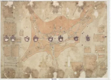
Fig. 1. Map showing the fountains to be repaired in Mecca, 1/2500, from 1341 (Hijri), (52x69)
II. OVERVIEWOFURBANEVOLUTION
European Orientalist scholars [12, 13, 14], despite Raymond’s [15] critique, those who first studied the “orient”, created the first model of Middle Eastern urban design. This model, developed in the early 20th century, is known as the Islamic City Model. This model and two others, namely the Zeigler Model and the Multiple-nuclei Model, provide different and interesting analytical perspectives of the Arabian city space. The traditional old city constitutes the heart of the Arabian city. While many of the unique Middle Eastern city characteristics represented in the old city are also found, to various extent, in other sectors, the ones that most differentiate the Arabian city from other cities of the world are most prominent in the old city center. Various physical characteristics unite the traditional Arabian cities and are common to most cities and towns larger than a village. Common traditional features such as the centrality of mosques, urban residential pattern, the urban marketplace and the organization of quarters are characteristics that make the cities of the Middle East. Other characteristics of the old city (the city wall, the citadel, and the palaces) are not as common as they once were of diminishing importance. Quarters are informally organized residential neighborhoods. They are a sub-component of the old city center. Most Arabian cities are informally and highly segregated. Neighborhoods organize themselves into homogeneous sections according to a variety of factors ranging from religion, ethnicity, occupation, tribal affiliation to regional affiliation, and economic status. Therefore, urban fabric in traditional Arab cities is very complex. It emerges as an outcome of interaction between the conditions of sites, the customs of the community and the legal mechanisms that are derived from the Islamic law. The major forces shaping the traditional city seem to be a balance between tribal custom and Islamic law, and driven by the dual concerns of privacy and community.
The Arabian cities, with particular reference to Mecca (Figure 3) and Medina (Figure 4), reflect the character of organic fabric of the cities of the mediaeval era. In addition to the definition of urban morphological features that characterize the Arab (or Middle Eastern) City by Morris [16], Eben Saleh [17,18] provides a comprehensive account of the transformation of Arab city, and Al-Hathloul [19] and Parssinen & Talip [20] analyze the transformation of cities of Eastern Province in particular. Thus, the Arab city, for a very long time almost until the mid-twentieth century, has retained its mediaeval character. In regard to the morphological summary of urban evolution in Arabian cities, it wouldn’t be unfair to suggest that the urban growth was almost non-existent until the end of the first quarter of the 20th century. Until that
period of time the settlements were quite isolated from each other. As the cartographical evidences on larger scales (such as railroad maps and telegram line maps found in Ottoman archives in Istanbul) reveal, the settlements were formed in morphologically compact arrangements. These settlements were built in small sizes and in human scale. The circulation systems exhibited a very organic and irregular character. Most of the street patterns in these cities resemble an intricate
Fig. 2. Map showing Medina-i Munavvarah, , 1/2500, from 1330 (Hijri), (63x81)
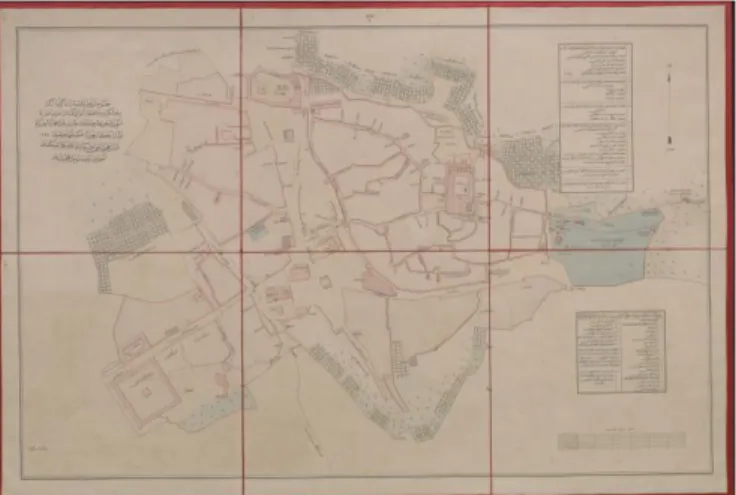
Fig. 4. Map of Medina and surroundings, 1/2000, from 1297 (Hijri), (68x100 cm)
Fig. 3. Map showing the plan and the vicinity of the guesthouse in relation to Harem-i Serif in Mecca, 1/4000, from 1310 (Hijri), (50x61 cm)
network. Moreover, they were quite introverted. Various scholars associate this quality with the religious character of the social structure [21]. According to this view, particularly the reflection of gender segregation due to religious framework seems to be major determinant of the urban morphology [22]. On the contrary to these associations, Akbar’s introductory chapter in Elsheshtawy’s Planning Middle Eastern Cities [23], brings a deeper insight into the relationship with religion and the urban morphologyby providing a controversial perspective on the underlying principles of land ownership rights according to Islamic law. He explores how the land ownership and the nuances of public right of access to assets below the ground affects the capability of Islamic cities in the Middle East to cope with radical changes. Thus, briefly, the transformation of Arab city until the end of 20th century can be
summarized by a gradual shift from an urban texture of pedestrian scale and formal homogeneity of the physical environment into a fabric of vehicular scale and formal fragmentation of the physical environment [24].
III. PRINCIPLESOFMORPHOLOGICALTRANSFORMATION
The principles derived from the cities of Arabian Peninsula seem to confirm urban theories that explain city as a self-organizing organism rather than a static design product. Furthermore, the cartographical data shows that the plannimetric configuration of the cities of Arabian Peninsula is organized in parallel to the way our spatial intelligence conventionally works [25]. The salient qualities that stimulate the human spatial intelligence are mainly the primary morphological features of a mediaeval city. They are further enriched, here, by characteristics of Middle Eastern settlement forms.
The morphological analysis of the cartographical data shows that the archetype of Islamic city has always accommodated an organic network of isolated courtyards and cul-de-sacs as the circulation system within these confined settlements. Moreover, the wall emerges as a salient component throughout the urban fabric which not only serves definition of space but also configuration of the hierarchy of privacy that determines traditional way of living in these settlements. Majority of the cartographical evidences support the existence of a balanced figure-ground relationship with the settlement plans.
An alternative reading regarding the multiple personalities of cities [26] is necessary to give meaning to this intriguing evolution of Arab city today. As a matter of fact, it is very interesting to observe how easily traditional fabric is destroyed and even erased in such a traditional society. As mentioned above, the intrinsic qualities of Islamic city, which are well-rooted in the nuances of Islamic law, seems to play a significant role in explaining this paradox.
Presently, these cities are faced with the dichotomy of preserving a deep and stratified cultural heritage on the one hand, and creating a new glamorous (yet superficial) physical stage set for the new way of contemporary living. Thus, the conflict between old and new, is tackled in such a way that the clashes are disguised by contemporary means of urban
perception, that is to say by speed [27]. Hence, looking at the current transformation of the cities of Arabian Peninsula, it can be claimed, in this paper, that the future of traditional urban morphologies and its associated culture is significantly threatened by the massive urbanization process because many patterns of daily life as well as ways of perceiving the immediate urban environment is being irreversibly altered for humans to an extent that urban-architectural heritage is almost destroyed.
IV. CONCLUSION
The paper intended to analyse the morphology of Arabian cities by unveiling the cartographical data hitherto kept in Ottoman archives. Along this goal, the research was conducted so as to provide access to these archives and to retrieve maps and plans of cities in Arabian Peninsula between 18th and 20th
centuries. The findings of this research show that available documentation focuses on two major cities and rarely on other settlements. This leads us to two plausible interpretations rather than conclusions; either the other cities were so small in scale that they were not significant settlements, or, due to Bedouin and nomadic way of living, little concern was given to settlements. In both cases, having analyzed a series of cartographical documents about cities of Arabian Peninsula as obtained from Ottoman archives, the following characteristics are inferred; organic growth, complex circulation networks and introverted spatial configuration [28]. There is almost no indication, in the cartographical documents, of the emergence of grid until the mid 20th century. After this point in time, it is
possible to observe insertion of fragmented grids into the urban fabric accompanied by a reversal of figure ground relationship towards a figure dominated tissue [29]. Since dichotomous morphologies usually point out physical symptoms of segregation and conflict, these insertions and morphological fragmentations signify an inflection point in the evolution of Arabian cities.
Eventually, it seems that the Arab city has been transformed from a humane fabric which is pedestrian in scale, harmonious and integrated in terms of urban space, into a new and inhumane fabric that can be defined as vehicular and monumental in scale and spatially fragmented as a result of global urbanization processes over the course of time. This paper unveils the traces of patterns within this transformation and reveals the sudden leaps at the beginning of the 20th
century. Following successive waves of Westernization, the Arab city seems, now, to be facing the latest, and probably the most intensive phase of global development which significantly alters the underlying structure of the urban morphology [30]. As the cartographical findings put forward, there is a significant difference between the traditional fabric and current city plans. Therefore, traditional urban culture is seriously threatened by this massive urbanization process [31]. Patterns of daily life and ways of perceiving the immediate urban environment is being irreversibly altered causing urban-architectural heritage to be totally destroyed. However this process is implemented so gradually and discretely that it is
almost unnoticed and even welcomed by the native and local people [32]. Particularly with the instruments that are raised by Al-Hathloul [33], namely grid and urban villa, the coherence of social unity is broken. In other words, the ongoing rapid urbanization under the pressure of the dynamics of global economy seems to create immense contrasts regarding; human & monumental scale, horizontal & vertical forms, walled & open settlements, luxurious & dilapidated buildings right next to each other in the morphology of Arab cities.
The roots of currently ongoing and well-disguised trickery of rapid urbanization as the agent of globalism are investigated in the evolution of both urban morphological and intangible cultural aspects. Particularly, in the light shed by above-analyzed problem of fragmentation, there is an urgent need for an emphasis on the issues of preservation and conservation of urban heritage as well as vernacular architecture, in urban planning, for reconstructing the broken ties with past which spiritual and social values regarding community were essential aspects of urban living.
Consequently, the study provided the systematic documentation of the cartographical inventory of Arabian cities within the given range of timescale. As it was initially intended, plausible patterns or principles of morphological transformation from one phase to another in the growth and evolution of major cities are also derived through methods of analyses developed in the field of urban morphology. Therefore, the two fold goals of this study are accomplished.
Remarks on Future Projections
Having provided an inventory of cartographical information retrieved from recently opened Ottoman archives, the project is expected to reveal sound and concrete basis on which evaluations can be made regarding the urban history of Saudi Arabian cities and their transformation between 18th and 20th
centuries. This is conceived as a scientific scrutiny whereby the outcomes of this research may enable many researchers in the disciplines of city planning and urban design to shed light in new and diverse readings on urban history of Saudi Arabia; either supporting the existing literature and accumulated knowledge or bringing totally new ramifications and interpretations about the urban history of Arabian Peninsula. Thus, this research is considered as a chance to gather cartographical data kept hidden for a very long time particularly outside the Arabian Peninsula.
V. ACKNOWLEDGEMENTS
We would like to express our gratitude to King Fahd University of Petroleum & Minerals that provided the opportunity to make this study by sponsoring the research. We also would like to extend our appreciation to personnel of Ottoman Archives as well as personnel of IRCICA and ISAM in Istanbul who were very helpful in providing the information. Special thanks to Dr. Filippo Beltrami Gadola for his help.
REFERENCES
[1] Kropf, K., “Aspects of Urban Form”, Urban Morphology, vol.13, no.2, pp.105-120,2009.
[2] Conzen, M.P., `Analytical approaches to the urban landscape', in Butzer, K. (ed.) Dimensions in human geography Research Paper no. 186, Department of Geography, University of Chicago, 1978.
[3] Cataldi, G., Maffei, G.L. and Vaccaro, P. (1997) `The Italian school of process typology', Urban Morphology vol. 1, 49-50, 1997 ( and see
ensuing debate with Malfroy, Levy and Kropf, 50-60 )
[4] Maffei, G.L., Cataldi, G., and Vaccaro, P., `Saverio Muratori and the Italian school of planning typology', Urban Morphology vol. 6 (1) , 3-20, 2002.
[5] Whitehand, J.W.R., `British urban morphology: the Conzenian tradition', Urban Morphology vol. 5(2), 103-109, 2001.
[6] Whitehand, J.W.R., `Recent advances in urban morphology', Urban
Studies vol. 29,. 617-634, 1992.
[7] Whitehand, J.W.R., `M.R.G. Conzen and the intellectual parentage of urban morphology', Planning History Bulletin vol. 9(2), 35-41, 1987. [8] Serageldin, I., Historic cities and sacred sites: cultural roots for urban
futures, The World Bank, Washington, DC, USA, 2001.
[9] Eben Saleh, M.A., Al-But’hie, I.M. , ‘Urban and industrial development planning as an approach for Saudi Arabia:the case study of Jubail and Yanbu’, Habitat International 26 ,1–20, 2002.
[10] Al-Naim, M., Mahmud, S. , ‘Transformation of traditional dwellings and income generation by low-income expatriates: The case of Hofuf, Saudi Arabia’, Cities 24 ,422–433, 2007.
[11] Cetin, M., ‘Contrasting Perspectives on the Arab City’, Urban
Morphology, vol.15 (1) [ISSN 1027-4278], 81-85, 2011.
[12] Morris, A.E.J., History of Urban Form: Before the Industrial
Revolution, Prentice Hall, 1996.
[13] Lewis, B., The Middle East: A Brief History of the Last 2000 Years, New York: Simon and Schuster, 166, 1995.
[14] Al Sayyad, N., Cities and Caliphs: On the Genesis of Arab Muslim
Urbanism, New York: Greenwood Press, 39-41, 1991.
[15] Bianca, S., Urban Form in the Arab World: Past and Present (New York: Thames and Hudson, 2000.
[16] Raymond, A., Arab Cities in Ottoman Period, Aldershot; Ashgate, 2002.
[17] Eben Saleh, M.A., ‘Place Identity: The Visual Image of Saudi Arabian Cities’, Habitat International 22 ,149–164, 1998.
[18] Eben Saleh, M.A., ‘Learning from tradition: the planning of residential neighborhoods in a changing world’, Habitat International 28, 625– 639, 1998.
[19] Al-Hathloul, S. A., Tradition, Continuity, and Change in the Physical Environment: The Arab-Muslim City. Unpublished Ph.D. Thesis, Department of Architecture, MIT, 1981.
[20] Parssinen,J. & Talip,K., ”A Traditional Community & Modernization: Saudi Camp, Dhahran”, JAE, vol. 35, no.3, Blackwell Publishing: Oxford, pp.14-17, 1982.
[21] Hakim, B. S., Arabic-Islamic cities: building and planning principles, Routledge, New York, 1986; Mortada, H., Traditional Islamic principles of built environment, Routledge Curzon, London, UK, 2003; Al-Hathloul, S., ‘Continuity in a changing tradition’, in Davidson, C. (ed.) Legacies for the future: contemporary architecture in Islamic societies, Thames & Hudson, London, 1998; Eben Saleh, et al., ibid.
[22] Massey, D., Space, Place & Gender, Polity; Camb., 1994.
[23] Yasser Elsheshtaway, Y., Planning Middle Eastern Cities: an urban
kaleidoscope in a globalizing world, Routledge, London, UK, 2004; see
Akbar, J., “The Merits of Cities’ Locations”, in Planning Middle
Eastern Cities: An Urban Kaleidoscope (ed. Y. Elsheshtawy),
(Routledge, New York, 2004.
[24] Cetin, M., ‘Transformation And Perception Of Urban Form In Arab City’, International Journal of Civil & Environmental Engineering
IJCEE-IJENS , vol.10 (4),.30-34, 2010.
[25] Van Schaik, L., Spatial Intelligence; New Futures for Architecture, Wiley, 2008
[26] Cohen, P., “From the Other Side of the Tracks: Dual Cities, Third Spaces, and the Urban Uncanny in Contemporary Discourses of “Race” and Class”, A Companion to the City (ed. G. Bridge and S. Watson), Blackwell, pp.316-330, 2002.
[27] Cetin, M., Emergent ‘Double Identity’ of Historic Cities; Problems of Urban-Architectural Heritage in Islamic Domain”, Proceedings of
FICUAHIC, Riyadh, Saudi Arabia, 2010.
[29] Trancik, R., Finding Lost Space, Theories of Urban Design, Van Nostrand Reinhold, New York, 1986.
[30] Eben Saleh, et al., 2002, ibid.
[31] Eben Saleh, M.A., ‘Environmental cognition in the vernacular landscape: assessing the aesthetic quality of Al-Alkhalaf village, Southwestern Saudi Arabia’, Building and Environment, 36, 965–979, 2001.
[32] Cetin, 2010, ibid. [33] Al-Hathloul, 1981, ibid.
Murat Cetin studied architecture at Middle East Technical University where he received his B.Arch and M.Arch degrees. He received his PhD degree from University of Sheffield where he was awarded a governmental scholarship.
He worked as assistant professor in Balikesir University and Yeditepe University in Turkey. He conducted various design projects some of which are awarded and funded research projects besides his teaching duties both on conservation and design theory as well as design studios. He directed various international workshops. He published various articles, papers and book chapters. He currently teaches in KFUPM in Dhahran in Saudi Arabia. His current research interests include urban morphology, urban transformation, urban conservation and history and theory of urban design.
Adel S. Al-Dosary studied Architectural engineering at KFUPM and received his Master’s and PhD degrees in University of Michigan, Department of Urban Planning. He has various published and research work in the field of planning and management. He is currently the chairman of both Departments of Architecture and City and Regional Planning at KFUPM. He also hold various administrative positions at the regional and national level in Saudi Arabia.
Senem Doyduk graduated from Trakya University Department of Architecture. She received her Master’s degree from 9 Eylul University of Izmir in Turkey and her PhD. from Yildiz Technical University in the field of architectural and urban conservation. She has a track record of several publications at national and international platforms. She is currently affiliated, as an assistant Professor, with Dogus University Department of Architecture in Istanbul.
Banu Celebioglu studied architecture at . She became a teaching assistant in Yildiz Technical University Department of Architecture in the Discipline of Restoration after she worked for various architectural offices. She is currently working as a Research Assistant in the same department. She has several publications in her field and she was involved in various research projects.