Tar. Bil. Der.
Dergi web sayfası: www.agri.ankara.edu.tr/dergi
Journal homepage: www.agri.ankara.edu.tr/journal
Morphology, Physico-Chemical Properties and Classification of
Soils on Terraces of the Tigris River in the South-east
Anatolia Region of Turkey
Orhan DENGĐZ
Ondokuz Mayis University, Agriculture Faculty, Department of Soil Science, 55139 Samsun, TURKEY ARTICLE INFO
Research Article Natural Resources Management and Landscape Planning
Corresponding author: Orhan DENGĐZ, e-mail: [email protected], Tel: +90(362) 312 19 19/1463 Received: 07 January 2009, Received in revised form: 29 October 2010, Accepted: 03 December 2010
ABSTRACT
Alluvial soils, formed by rivers as accumulated sediment deposited at different times, show large variations in their properties over short distances. The main aims of this study were to determine the morphological and physico-chemical properties and classify the soil profiles of four different geomorphological units along transects on the right bank of the Tigris River in the Hevsel Bahceleri district of Diyarbakır. These soils were formed on the quaternary alluvial deposits on the young and old terraces, and the flood plain. The formation of soils was highly associated with major climatic factors and parent materials influenced the soils morphological and physico-chemical characteristics. Soil profiles formed on the old terraces located far from the Tigris River had well developed vertical succession horizons. The profile formed on the floodplain was characterized by weak pedogenesis. Development of the B horizon (Bw, Bt, Bss) and carbonate accumulation were the main pedogenic processes in terrace soils, whereas the profile formed on the floodplain had redoximorphic features at less than 2 m depth. According to analytical and morphological data, the four soil profiles were classified as Entisol, Inceptisol, Alfisol and Vertisol.
Keywords: Soil formation; Soil morphology; Soil classification; Tigris River
Türkiye’nin Güneydoğu Anadolu Bölgesinde Dicle Nehrinin Oluşturduğu
Teraslar Üzerinde Yer Alan Toprakların Morfolojisi, Fiziko-Kimyasal
Özellikleri ve Sınıflandırılması
ESER BĐLGĐSĐ
Araştırma Makalesi Doğal Kaynak Yönetimi ve Peyzaj Planlama
Sorumlu Yazar: Orhan DENGĐZ, e-posta: [email protected], Tel: +90(362) 312 19 19/1463 Geliş tarihi: 07 Ocak 2009, Düzeltmelerin gelişi: 29 Ekim 2010, Kabul: 03 Aralık 2010
ÖZET
Aluviyal topraklar akarsuların değişik zamanlarda getirmiş oldukları depozitler üzerinde oluşmalarından dolayı kısa mesafeler içerisinde çok farklı özellikler gösterebilmektedir. Bu çalışmanın amacı, Diyarbakır- Hevsel Bahçeleri bölgesi, Dicle Irmağının sağ yakasında yer alan dört farklı jeomorfolojik ünite üzerinde oluşmuş dört adet farklı toprak profilinin fiziksel, kimyasal ve morfolojik özelliklerini belirlemek ve sınıflandırmaktır. Bu topraklar kuaterner ana materyalli depozitlerin yer aldığı taşkın düzlüğü, genç ve yaşlı teraslar üzerinde oluşmuşlardır. Toprak
T
A
R
IM
B
İL
İM
LE
R
İ
D
E
R
G
İS
İ
J
O
U
R
N
A
L
O
F
A
G
R
IC
U
LT
U
R
A
L
S
C
IE
N
C
E
S
16 ( 20 10 ) 20 5-21 2
oluşmuş toprakların ileri düzeyde gelişmiş birbirini izleyen horizonlara sahip oldukları saptanmıştır. Bununla birlikte taşkın düzlüğü üzerinde yer alan topraklar ise zayıf pedolojik gelişimlere sahip oldukları tespit edilmiştir. Teras topraklarının B horizon gelişimi (Bt, Bw, Bss) ve karbonat birikimi önemli toprak oluşum işlemleri olarak belirlenmiştir. 2 m’den az toprak derinliğinde gözlenen redoksimorfik (sarımsı-kahverengi, kahverengimsi-kırmızı renk benekleri) sarımsı özellikler ise taşkın düzlüğünde yer alan toprakların ana toprak oluşum olayı olarak belirlenmiştir. Çalışma alanı thermic toprak sıcaklık ve xeric toprak nem rejimlerine sahip olduğu tespit edilmiştir.. Analitik ve morfolojik verilere göre dört toprak profili toprak taksonomisi temel alınarak Entisol, Inceptisol, Alfisol ve Vertisol ordolarında sınıflandırılmıştır.
Anahtar sözcükler: Toprak oluşumu; Toprak morfolojisi; Toprak sınıflaması; Dicle Nehri
© Ankara Üniversitesi Ziraat Fakültesi
1. Introduction
The differences in soil characteristics associated with landscape position are usually attributed to differences in the runoff, erosion and deposition processes which affect soil genesis (Brikeland 1984, Yair 1990, Dahlgren et al 1997, Lark 1999 Canton, 2003). Stratification, the alternation of pedological layers and layers of new material, is a particular characteristic of alluvial soils (Gerrard 1987). Therefore, the characteristics of alluvial soils change from region to region or from place to place (Birkeland 1999 & Dengiz et al 2006). However, this change is not coincidental. Alluvial soils are the result of processes of erosion and
deposition, and therefore exhibit various
characteristics reflecting the composition and properties of the material transported (Weber & Gobat, 2006). Moreover, these processes of sedimentation and erosion vary spatially and temporally, and thus contribute to the heterogeneity of the whole floodplain system. Detailed analysis of different soil layers permits a precise description of the variability and complexity of soil formation. Alluvial soils, which have the capacity for high productivity, often show large variations in their properties over short distances. These soils have traditionally been classified according to the old American classification system Baldwin et al (1938).
However, that system has since been deemed incapable of properly determining and describing the properties of alluvial soils. Today, many countries use the soil classification systems of Soil Taxonomy (1999) and the FAO (2006). An alluvial soil classified according to the morphometric system has various characteristics reflecting the
composition and properties of the material transported. In addition, the soils mapped according to this system can be easily employed in later land use planning studies.
The objectives of this study were to use transects to determine the morphological and physico-chemical characteristics of the soils developed on alluvial deposits along terraces and the floodplain of the Tigris River, and also to classify those soils. This study also sought to provide useful data on the soil genesis and characteristics of those same alluvial plains.
2. Materials and Methods
2.1. Study area
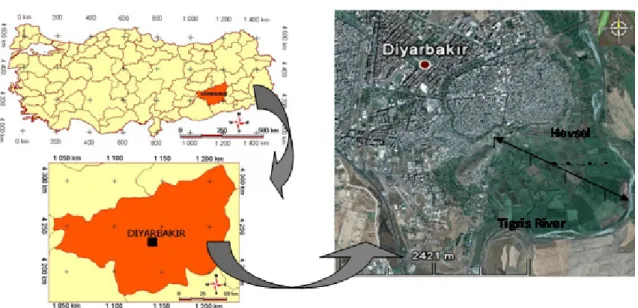
In this study, four soil profiles formed on different terraces and the floodplain on the right bank of the Tigris River in Diyarbakir’s Hevsel-Bahçeleri district were investigated. The transect distance from the river to the highest terrace was approximately 1,500 m. The study area is located
between 37°53’ N and 40° 14’ E (Figure 1), and
ranged in elevation from 505 to 589 m. Different
terraces, representing a spectrum of
geomorphology, topographic gradients and soil characteristics, were selected (Figure 2). The underlying parent material within the study area consists primarily of quaternary alluvial deposits found on old and young terraces, and floodplain. The climate of the study area is warm and semiarid, with a mean annual air temperature of 16.3°C, a mean annual precipitation of 487.4 mm, and potential total evaporation of 1,827 mm. The soil moisture regime is xeric (Soil Survey Staff 1999) and soil temperature regime is thermic. The study area is predominantly used for irrigated agriculture.
Figure 1-Location of the study area in South-eastern Turkey (at three scales)
Şekil 1-Türkiye’nin güney-doğusunda yer alan çalışma alanının lokasyonu (üç ölçekte)
2.2. Physical and chemical analysis
A total of 38 undisturbed and disturbed soil samples were collected from each horizon for laboratory analysis. The soil samples were air dried, crushed and screened using a 2 mm sieve. Particle size distribution was determined by the hydrometer method (Bouyoucos 1951), and bulk density was determined from undisturbed samples (Blacke & Hartge 1986). Organic matter in air-dried samples was determined by the Walkley-Black wet digestion method (Nelson & Sommers 1982). pH and EC-electrical conductivity were determined according to the methodology of the Soil Survey Laboratory (1992). Lime content was determined by Scheibler calsimeter (Soil Survey Staff 1993). Exchangeable cations and cation exchange capacities (CEC) were measured by using the 1 N
NH4OAC (pH 7) method (Soil Survey Laboratory,
1992). In addition, morphological properties of the four profiles were determined by sampling genetic horizons in the field, and soils were classified according to the methodologies of the Soil Survey Staff (1993 & 1999) and FAO/ISRIC (2006).
3. Results and Discussion
3.1. Soil morphology and classification
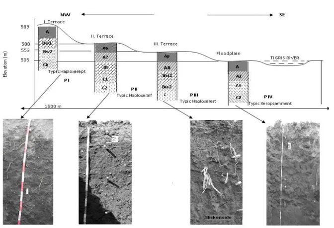
The investigated soils developed from alluvial material deposited by the Tigris River on its terraces and floodplain (Figure 2). Alluvial soil morphology varies according to landscape position and overbank lithofaces (Autin & Aslan 2001), and also because of river modifications through time, such as embankments and dam construction. These geomorphic processes produce a landscape mosaic reflected in abrupt juxtapositions of soils of different ages and degrees of profile development (McAuliffe 1994). In addition, Leopold & Miller (1956), Graf (1982) and Alexander et al (1999) reported that alluvial lands and floodplains formed under ephemeral flow regimes, especially in arid and semi-arid regions, lack many of the relationships between hydrology, sedimentology and morphology that apply to perennial rivers. According to those authors, the concept of pedogenic maturity is used to infer sediment accumulation rates at different locations in ancient floodplain environments: weak soil development is assumed where sedimentation rates are rapid and strong development is presumed where sediment accumulation is slow. Profile I (P I) developed on terrace 1 which is the oldest terrace in the study area. Slope is one of the most important factors controlling the pedogenic process on P I. Slope contributes to greater runoff, as well as to greater
Figure 2-Different soil profiles along transects of three terraces and the floodplain of the Tigris River near Diyarbakir in south-eastern Turkey
Şekil 2-Dicle Irmağının oluşturduğu taşkın düzlüğü ve teraslar üzerindeki farklı toprak profil kesitleri
translocation of surface materials down slope through surface erosion and movement of soil. Clay loam was the dominant texture in PI. Soil color was 2.5 YR 5/2 in the Ap horizon, while, due to carbonate accumulation at depth, the color changed to 5 Y 6/2 in subsurface horizons. Secondary
CaCO3 nodules and mycelia were also identified in
P I, which indicated carbonate leaching and accumulation (Table 1). Calcium carbonate nodules, starting in the Bw2 horizon at a depth of 78 cm, increased in both thickness and diameter in the Ck1 horizon. The main diagnostic horizon was the cambic horizon developed in the structural formation of this profile. Structural development was most noticeable between 15 and 123 cm. Using Soil Taxonomy (1999) and FAO/ISRIC (2006) as references, this profile was classified as Typic Haploxerept and Eutric Cambisol.
The morphology of P II located on terrace 2 was different from PI. The horizon orders in PII were defined as Ap-A2-Bt-2Cb-2C2. All profiles had a clay loam texture, except the C horizon, which had a clay texture. Due to clay illuvation (movement of clay from upper horizons), clay accumulation was observed between 34 and 79 cm depth. Between these depths, the morphological property known as clay cutans was also observed. This property is attributable to clays elluviating down to the lower layers and accumulating as a thin membrane on the surfaces of sub-angular blocky structures in the B horizon. The main subsurface diagnostic horizon in P II was the argillic horizon. Boul & Hole (1961) stated that an argillic horizon must contain a minimum clay increase relative to the elluvial horizon or an underlying horizon, and show evidence of clay movement. Soil color was 5 Y 5/2
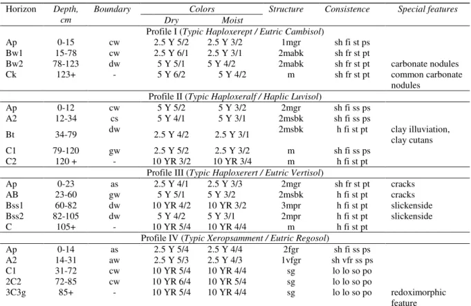
Table 1-Some morphological characteristics of profiles
Çizelge 1-Profillerin bazı morfolojik özellikleri Colors Horizon Depth,
cm
Boundary
Dry Moist
Structure Consistence Special features
Profile I (Typic Haploxerept / Eutric Cambisol)
Ap 0-15 cw 2.5 Y 5/2 2.5 Y 3/2 1mgr sh fi st ps
Bw1 15-78 cw 2.5 Y 6/1 2.5 Y 3/1 2mabk sh fr st pt
Bw2 78-123 dw 5 Y 5/1 5 Y 4/2 2mabk sh fr st pt carbonate nodules
Ck 123+ - 5 Y 6/2 5 Y 4/2 m sh fr st pt common carbonate
nodules Profile II (Typic Haploxeralf / Haplic Luvisol)
Ap 0-12 cw 5 Y 5/2 5 Y 3/2 2mgr sh fi ss ps A2 12-34 cs 5 Y 4/1 5 Y 3/1 2msbk sh fi ss ps Bt 34-79 dw 2.5 Y 4/2 2.5 Y 3/1 2msbk h fi st pt clay illuviation, clay cutans C1 79-120 gw 2.5 Y 5/2 2.5 Y 3/2 m sh fi ss ps C2 120 + - 10 YR 3/2 10 YR 3/4 m h fi st pt
Profile III (Typic Haploxerert / Eutric Vertisol)
Ap 0-23 as 2.5 Y 4/1 2.5 Y 3/3 2mgr sh fr st pt cracks
AB 23-60 gw 5 Y 5/1 5 Y 3/2 2msbk h fi st pt cracks
Bss1 60-82 dw 10 YR 4/2 10 YR 3/2 3mpr h fi st pt slickenside Bss2 82-105 dw 5 Y 4/2 5 Y 3/1 2mpr h fi st pt slickenside
C 105+ - 10 YR 5/4 10 YR 4/4 m h fi st pt
Profile IV (Typic Xeropsamment / Eutric Regosol)
Ap 0-14 as 2.5 Y 5/4 2.5 Y 4/4 2fgr sh fi ss ps A2 14-31 aw 2.5 Y 5/3 2.5 Y 4/3 1vfgr sh vfr ss ps C1 31-72 cw 10 YR 5/4 10 YR 4/4 sg lo lo so po 2C2 72-85 cw 10 YR 6/4 10 YR 5/4 sg lo lo so po 3C3g 85+ - 10 YR 5/4 10 YR 4/4 sg lo lo so po redoximorphic feature Abbreviations:
Boundary: a = abrupt; c = clear; g = gradual; d = diffuse; s = smooth; w = wavy; i = irregular
Structure: 1 = weak; 2 = moderate; 3= strong; sg = single grain; m = massive; vf = very fine; f = fine; m =medium; c = coarse; gr = granular; pr = prismatic; abk = angular blocky; sbk = subangular blocky. Consistence: (Dry) lo = loose; so = soft; sh = slightly hard; h = hard; (Moist) lo = loose; vfr = very friable; fr = friable; fi = firm; (Wet) so = nonsticky; ss = slightly sticky; st= sticky; po = non-plastic; ps = slightly plastic; pt= plastic
in the Ap horizon, 2.5 YR 4/2 in the Bt horizon, and 2.5 Y 5/2 in the C horizon (Table 1). Due to the main soil formation process being argilluviation, this profile was classified as Typic Haploxeralf and Haplic Luvisol, as per Soil Taxonomy (1999) and FAO/ISRIC (2006).
Profile III formed on the youngest terrace of the study area as an alluvial clay deposit. This profile
did not contain any CaCO3 nodules. The occurrence
of cracks 1 - 5 cm in width at the surface of this soil during dry periods is the result of high levels of clay. This profile had intersecting slickenside and shiny pressure faces in the subsurface horizon, indicating the shrink-swell properties of the soil. Moderate granular and medium subangular blocky structures were observed in surface horizons, while
a strong prismatic structure characterized subsoil horizons. The presence of a layer more than 25 cm thick and characterized by slickensides, with more than 30 percent clay and with 1 - 5 cm wide cracks up to 1 meter deep, qualified it as a Vertisol. Therefore, P III was classified as Typic Haploxerert (Soil Taxonomy 1999) and Eutric Vertisol (FAO/ISRIC 2006).
Profile IV was located on the floodplain which was also formed from alluvial parent material. For semi-arid, cut-and-fill floodplains, Daniels (2003) and Weber and Gobat (2006) defined three alluvial pedofaces. These three soils were shown to have developed different pedogenic features through time as a result of different aggradation rates. Daniels (2003) also defined A horizons as soil
stratigraphic markers and indicators of relative aggregation rates. Thus, according to that author, identification of different soil horizons, reflecting different aggregation phenomena due to floods or development of a weak soil structure, seems to be the ideal approach for precisely describing the variability and complexity of alluvial soil profiles. The same situation was observed in the study area, so the same classification approach was adopted. There is an abrupt textural transition from old river terrace soils to the floodplain soils in P IV that have silty loam and sandy loam textures. This change has also affected structural development of the transect soils. Owing to its lack of organic matter and fine texture, the structural development of P IV was moderate to weak, and it had a fine to very fine granular (2fgr and 1vfgr) mixed structure in surface horizons (Table 1). The profiles of the floodplain had pebbles and cobbles in common at greater than 72 cm depth. Structure had also not developed after this depth. In addition, floodplain soils, where there was water table fluctuation, had redoximorphic features seen as brownish red mottles at less than 2 m depth. The horizon succession of profile PIV was defined as A-C. This means that this profile had no diagnostic subsurface horizons and low pedogenetic development. Therefore, Profile IV can be defined as a young soil and classified as Typic Xeropsamment (Soil Taxonomy 1999) and Eutric Regosol (FAO/ISRIC (2006).
There was no epipedon in surface soils of all the soil profiles, except in Profile IV, which had an ochric epipedon. Ochric epipedon has a Munsell color value of 4 or more when moist, and 6 or more when dry; or chroma of 4 or more; or includes an A or Ap horizon that has both a low color value and low chroma. In addition, it also includes a horizon of organic materials that is too thin to meet the requirements of a mollic epipedon (Soil Taxonomy 1999).
3.2. Physical and chemical properties
Soil physical and chemical properties show variability as a result of dynamic interactions among environmental factors such as climate, parent material, topography and land cover/land use (Dengiz et al 2006). The major physical and chemical properties of the soils in the current study
are presented in Table 2. Their pH was moderately alkaline and ranged from 8.1 to 8.5. In addition, all profiles had a slight amount of soluble salts. Soil texture varied from clay loam through clay to silty clay across the surface soils of all profiles. Typic Haploxerert had the highest clay content, while Typic Xeropsamment had the highest sand content.
Soil CEC varied between 11.4 and 52.66 cmol kg-1.
The soil with the highest CEC was the Typic Haploxerert which had the highest clay content, while Typic Xeropsamment soil had the lowest clay content. On the other hand, Typic Xeropsamment had a higher bulk density than other profiles due to its high sand content. The calcium carbonate content of profiles was high, although the P I and P II profiles had much higher calcium carbonate contents due to carbonate accumulation in their calcic horizons (Table 2). On the other hand, the
low amount of CaCO3 in P III and P IV may be
explained by leaching of CaCO3 from the profile.
Exchangeable Ca and Mg cations accounted for over 95% of the exchangeable complex as a result of the dissolution of carbonates, whereas exchangeable K and Na levels were rather low. For all soils, the organic matter level was highest in the surface horizon and decreased sharply to its lowest level in the subsoil. Soil organic matter content ranged from 1.1% to 3.8% in upper horizons. These low organic matter levels are attributable to rapid decomposition and mineralization of organic matter due to cultivation practices
4. Conclusion
The soils of the alluvial deposits on different terraces and the floodplain of the Tigris River at Diyarbakir in south-eastern Turkey were highly heterogeneous, and display distinctive pedologic characteristics due to frequent depositional disturbances through flooding, as well as erosional processes. All profiles, except for profile IV, were generally of fine texture due to excessive weathering. Typic Haploxerept, Typic Haploxeralf, Typic Haploxerert and Typic Xeropsamment were the taxonomic classes encountered in the study area. Moreover, these soils were classified as Eutric Cambisol, Haplic Luvisol, Eutric Vertisol and Eutric Regosol.
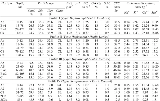
Table 2-Some physical and chemical properties of profiles
Çizelge 2-Profillerin bazı fiziksel ve kimyasal özellikleri
Particle size Exchangeable cations,
cmol kg-1 Horizon Depth, cm Sand, % Silt, % Clay, % Class B.D, g m-3 pH EC, dS m-1 CaCO3, % O.M, % CEC, cmol kg-1 Na+ K + Ca+2 Mg+2 Profile I (Typic Haploxerept / Eutric Cambisol)
Ap 0-15 38.1 33.3 28.6 CL 1.23 8.2 1.25 11 3.0 38.5 0.74 2.97 25.44 11.35 Bw1 15-78 26.3 39.9 33.8 CL 1.25 8.3 1.32 13 2.0 39.4 0.45 1.62 28.24 9.69 Bw2 78-123 28.0 33.4 38.6 CL 1.26 8.5 1.38 16 1.1 39.3 0.93 1.07 20.58 18.43 Ck 123+ 24.7 36.4 38.9 CL 1.25 8.3 0.77 21 0.2 42.3 0.43 1.43 22.18 18.86
Profile II (Typic Haploxeralf / Haplic Luvisol)
Ap 0-12 32.8 34.4 32.8 CL 1.17 8.4 1.20 14 3.8 41.5 2.81 2.71 22.31 12.2 A2 12-34 29.7 38.4 31.9 CL 1.29 8.3 1.10 13 3.5 39.7 2.44 2.21 24.04 12.1 Bt 34-79 30.4 31.1 38.5 CL 1.12 8.3 0.74 13 2.2 37.2 2.34 3.35 18.67 12.2 C1 79-120 37.6 28.1 34.3 CL 1.17 8.3 0.88 11 1.3 35.0 1.83 2.52 17.72 13.2 C2 120 + 15.7 24.7 59.6 C 1.22 8.2 0.60 10 0.5 50.4 2.11 2.27 26.8 19.5
Profile III (Typic Haploxerept / Eutric Vertisol)
Ap 0-23 9.8 38.7 51.5 C 1.19 8.4 0.87 6 1.9 52.66 0.10 3.91 31.62 15.32 AB 23-60 8.8 33.2 58.0 C 1.13 8.3 0.85 5 1.5 50.28 0.66 3.21 31.41 16.20 Bss1 60-82 10.5 34.9 54.6 C 1.15 8.3 0.68 8 1.1 46.84 0.63 2.23 21.53 13.62 Bss2 82-105 15.1 31.1 53.8 C 1.19 8.2 0.82 5 0.6 40.19 2.04 3.47 25.63 11.65 C 105+ 15.0 30.4 54.6 C 1.26 8.3 0.68 5 0.4 38.01 3.01 3.35 22,56 11.70
Profile IV (Typic Xeropsamment / Eutric Regosol)
Ap 0-14 27.1 53.9 19.0 SiL 1.40 8.5 1.07 9 1.1 25.8 0.85 1.55 11.34 12.68 A2 14-31 31.9 52.2 15.9 SiL 1.37 8.4 1.01 8 1.0 26.4 0.89 1.61 14.45 11.04 C1 31-72 59.4 33.1 7.5 SL 1.40 8.3 0.95 7 0.9 14.5 1.00 1.27 9.97 1.44 2C2 72-85 78.5 15.0 6.5 LS 1.64 8.1 0.60 7 0.4 11.4 0.88 1.19 7.04 2.42 3C3g 85+ 43.8 45.6 10.6 L 1.47 8.2 0.98 8 0.5 12.5 0.91 1.19 9.23 1.81
CL: Clay Loam, C: Clay, SiL: Silty Loam, SL: Sandy Loam, LS: Loamy Sand, L: Loam, B.D: Bulk Density, O.M: Organic Matter, CEC: Cation Exchange Capacity
Acknowledgement
The author thanks Gregory T. Sullivan of OYDEM at Ondokuz Mayis University in Samsun, Turkey for editing of this manuscript.
References
Alexander J, Fielding C R & Pocock G D (1999). Floodplain Behaviour of the Burdekin River, Tropical North Queensland, Australia. In: M.G. Anderson, D.E. Walling and P.D. Bates, Editors, Floodplain Processes, Wiley, Chichester, pp. 27–40 Autin W J & Aslan A (2001). Alluvial pedogenesis in
Pleistocene and Holocene Mississippi River Deposits: Effects of relative sea-level change.
Geological Society of America Bulletin 113: 1456–
1466
Baldwin, M., Kellog, E.C. & Throp, J., (1938). Soil Classification. Year Book of Agriculture, USDA
Birkeland P W (1999). Soil and Geomorphology. Oxford Univ. Press, New York. 430 pp
Blacke G R & Hartge K H (1986). Bulk Density. In Klute, A. (ed). Methods of soil analysis. Part 1. Physical and mineralogical methods. 2nd ed.
Agronomy 9: 363-382
Boul S W & Hole F D (1961). Clay skin genesis in Wisconsin Soils. Soil Science Society of America 25: 377-379
Bouyoucos G J (1951). A Recalibration of the hydrometer method for making mechanical analysis of soils. Agronomy Journal 43: 435-438
Canton Y, Bent A S & Lazaro R (2003). Soil geomorphology relations in gypsiferour materials of the Tabernas Desert. Geoderma 115: 193-222 Dahlgren R H, Boettinger J L, Huntington G L &
Amundson R G (1997). Soil development along an elevational transect in the Western Sierra Nevada, California. Geoderma 78: 207-236
Daniels J M (2003). Floodplain aggregation and pedogenesis in a semiarid environment.
Geomorphology 56: 225–242
Dengiz O, Göl C, Karaca S & Yüksel M (2006). Effects of different landscape position and parent material on soil variability and land use in both sides of Acicay River-Çankırı. International Soil Meeting on Soil Sustaining Life on Earth, Managing Soil and Technology Proceedings Vol. II, 745-751, Şanlıurfa Turkey
FAO/ISRIC (2006). World References Base for Soil Resources. World Soil Rep., 103. Rome 128 p Gerrard J (1987). Alluvial Soils. Hutchinson Ross, New
York
Graf W L (1982). Spatial variations of fluvial processes in semi-arid lands. In: Space and time in Geomorphology (ed. By C. E. Thorn). Allen & Unwin, Boston
Lark R M (1999). Soil-landform relationships at within-field scales: An investigation using continuous classification. Geoderma 92: 141-165
Leopold L B & Miller J P (1956). Ephemeral streams hydraulic factors and their relation to the drainage net: U.S. Geological Survey 282: 1-37
McAuliffe J R (1994). Landscape evolution, soil formation, and ecological patterns and processes in
Sonoran Desert Bajadas. Ecological Monographs 64: 111-148
Nelson D W & Sommers L E (1982). Total Carbon, Organic Carbon and Organic Matter. In: Page, L.A., Miller, R.H., Keeney, D.R (Eds.), Methods of Soil Analysis, Part 2. Chemical and microbiological methods (2 nd ed). American Society of Agronomy, Madison, WI, pp. 539-579
Soil Survey Staff (1992). Procedures for Collecting Soil Samples and Methods of Analysis for Soil Survey. Soil Surv. Invest. Rep. I. U.S. Gov. Print. Office, Washington D.C. USA
Soil Survey Staff (1993). Soil Survey Manual. USDA Handbook. No: 18, Washington D.C. USA
Soil Survey Staff (1999). Soil Taxonomy. A Basic of Soil Classification for Making and Interpreting Soil Survey. USDA Handbook No: 436, Washington D.C. USA
Weber G B & Gobat J M (2006). Identification of faces models in alluvial soil formation: The Case of a Swiss Alpine Floodplain. Geomorphology 74: 181-195
Yair A (1990). The role of topography and surface cover upon soil formation along hill slopes in arid climates.