T.C.
SELÇUK ÜNİVERSİTESİ FEN BİLİMLERİ ENSTİTÜSÜ
PEDOGENIC EVALUATION AND CHEMICAL
WEATHREING RATES OF SOILS DEVELOPED ALONG AN ALTITUDINAL TRANSECT
Omar Tareq Abdulmajeed ALSALAM PhD THESIS
Soil Science and Plant Nutrition Department
May-2020 KONYA All rights reserved
Omar Tareq Abdulmajeed ALSALAM tarafından hazırlanan “Pedogenic Evaluation and Chemical Weathering Rates of Soils Developed Along an Altitudinal Transect” adlı tez çalışması 21/05/2020 tarihinde aşağıdaki jüri tarafından oy birliği ile Selçuk Üniversitesi Fen Bilimleri Enstitüsü Toprak Bilimi ve Bitki Besleme Anabilim Dalı’nda DOKTORA TEZİ olarak kabul edilmiştir.
Jüri Üyeleri İmza
Başkan
Prof. Dr. Sait GEZGİN ………..
Danışman
Prof. Dr. Cevdet ŞEKER ………..
Üye
Prof. Dr. Fetullah ARIK ……….. Üye
Doç. Dr. Hüseyin ŞENOL ……….. Üye
Dr. Öğr. Üyesi Emel ATMACA ………..
Yukarıdaki sonucu onaylarım.
Prof. Dr. Mustafa YILMAZ FBE Müdürü
Bu tez çalışması S.Ü. BAP Ofisi tarafından 18201141 nolu proje ile desteklenmiştir.
TEZ BİLDİRİMİ
Bu tezdeki bütün bilgilerin etik davranış ve akademik kurallar çerçevesinde elde edildiğini ve tez yazım kurallarına uygun olarak hazırlanan bu çalışmada bana ait olmayan her türlü ifade ve bilginin kaynağına eksiksiz atıf yapıldığını bildiririm.
DECLARATION PAGE
I hereby declare that all information in this document has been obtained and presented in accordance with academic rules and ethical conduct. I also declare that, as required by these rules and conduct, I have fully cited and referenced all material and results that are not original to this work.
Omar Tareq Abdulmajeed ALSALAM Tarih: 21.05.2020
iv
DOKTORA TEZİ
YÜKSELTİYE BAĞLI OLARAK DEĞİŞEN KESİT BOYUNCA TOPRAKLARIN PEDOJENİK GELİŞİMİ VE AYRIŞMA ORANLARI
Omar Tareq Abdulmajeed ALSALAM Selçuk Üniversitesi Fen Bilimleri Enstitüsü Toprak Bilimi ve Bitki Besleme Anabilim Dalı
Danışman: Prof. Dr. Cevdet ŞEKER
2020, 105 Sayfa Jüri
Prof. Dr. Cevdet ŞEKER Prof. Dr. Sait GEZGİN Prof. Dr. Fetullah ARIK Doç. Dr. Hüseyin ŞENOL Dr. Öğr. Üyrsi Emel ATMACA
Yükseklik iklimi etkileyen önemli bir faktör olup, toprak oluşum ve ayrışma oranları üzerinde önemli bir rol oynamaktadır. Türkiye, farklı yüksekliklere sahip bir ülkedir. İklim türünden bağımsız olarak, dağlık bölgelerdeki, özellikle de farklı yükseklikteki dağlık bölgelerdeki iklimsel özellikler, ortamlarına göre geniş ölçüde değişiklik gösterirler. Bu nedenle, yüksekliğin toprak oluşum ve ayrışma oranlarına etkilerini belirlemek için farklı yüksekliklerde dört farklı temsili toprak profil incelenmiştir. Çalışma alanında yükseklikler 1139 m ile 1809 m arasında olup, dört profilden yükseklik boyunca morfolojik, kimyasal, fiziksel, jeokimyasal ve mineralojik analizler için her horizondan toprak örnekleri alınmıştır. Toprak kimyasal alterasyon indeksi (CIA), Kimyasal Ayrışma İndeksi (CIW), Parker Ayrışma İndeksi (WIP), Plajiyoklas Alterasyon İndeksi (PIA), Mineralojik Alterasyon İndeksi (MIA), Kütle dengesi, A- CN-K diyagramları, bazı kökensel oranlar ve mineralojik özellikler farklı yükselmelere bağlı olarak iklimdeki pedojenik süreçleri karşılaştırmak için kullanılmıştır.
Ardışık iklim özellikleri, toprak taksonomik sınıflarını önemli ölçüde etkilemiştir. Daha fazla gelişmiş topraklar, daha yüksek su mevcudiyeti ile 1139 m'lik daha alçak yükseltilerde oluşturulmuş Typic Rhodoxeralfs (PI) topraklar, 1267 m irtifada Lithic Haploxeralfs (PII) olarak, 1633 m irtifada Typic Calcixerepts (PIII) olarak sınıflandırılan 1633 m irtifada, olarak sınıflandırılmıştır. 1809 m yükseklikte daha az gelişmiş topraklar oluşurken Typic Xerorthents (PIV) olarak sınıflandırılmıştır (USDA, 2014).
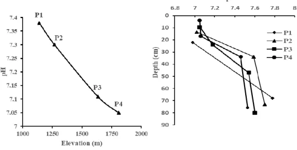
Elde edilen sonuçlara göre, yükseklik arttıkça toprak pH'sı, toprak elektriki iletkenliği (EC), katyon değişim kapasitesi ve değiştirilebilir katyonlar azalmıştır. Düşük yüksekliklerde melanizasyon, brunifikasyon ve argilluviasyon olayları hakim iken B horizonunun kalınlığı artmış, ayrışma oranları arttıkça kil miktarı ve Fed oranı da artmıştır. Mineral horizonlarının hacim ağırlığı ve CaCO3 içerikleri
düşük irtifalarda azalmıştır. Elde edilen sonuçlara göre, irtifanın azalmasıyla CIA, CIW, PIA ve MIA indeksleri ile birlikte kimyasal ayrışma oranının arttığı görülmüştür. Tersi durumda ise irtifanın artması ile WIP artmıştır. Öte yandan, incelenen tüm toprak profillerinin değerleri için düşük negatif Eu/Eu* oranının, artan ayrışma yoğunluğu ile ilişkili olduğu bulunmuştur. Bu bağlamda, irtifalara bağlı olarak spider diyagramları arasında anlamlı bir fark bulunmuştur. A-CN-K diyagramı, yaklaşımın düşük irtifalarında A apeksini diğer toprak yüksekliklerinden daha fazla sergilmiş, bu ayrışmış toprakların bileşiminin, topraktaki ve yağışa ek olarak suyun mevcudiyetinin ve akısının miktarından daha kolay etkilendiğini ve iklim farklılıklarının yükseklik farkından kaynaklandığını düşündürmektedir. Kütle dengesinin sonuçlarına göre, PI'in pozitif değerleri (daha düşük irtifalarda) ise, katyonların zenginleşmesi için su ile yukardan aşağıya elemanların taşınmasından kaynaklanmıştır. Toprak profillerindeki kil minerallerinin farkı, irtifa farklılaşmasının mineralojik farklılaşmayı etkilediğini göstermektedir. Sonuç
v
özesinde etkili olmuştur ve profiller arasındaki yükselti artığına bağlı olarak yağıştaki artış yoğun ayrışma oranlarına ve yoğun yıkanmaya neden olmuştur.
Bu çalışma, toprak özelliklerinin ve işlemlerinin, her ikisinin de yıkanma rejimini ve ayrışma oranlarını belirleyen yükseklik ve iklim koşullarıyla güçlü bir şekilde ilişkili olduğunu göstermiştir. Bu durum, iklimdeki değişimlerin farklı toprak türlerinde kayda değer değişiklikler ürettiğini göstermektedir.
Anahtar Kelimeler: Ardışık İklim, Ayrışma İndeksi, İrtifa, Jeokimyasal Değerlendirme, Toprak Oluşumu.
vi Ph.D THESIS
PEDOGENIC EVALUATION AND CHEMICAL WEATHERING RATES OF SOILS DEVELOPED ALONG AN ALTITUDINAL TRANSECT
Omar Tareq Abdulmajeed ALSALAM THE GRADUATE SCHOOL OF
NATURAL AND APPLIED SCIENCE OF SELÇUK UNIVERSITY THE DEGREE OF
DOCTOR OF PHILOSOPHY IN
SOIL SCIENCE AND PLANT NUTRITION Advisor: Prof. Dr. Cevdet ŞEKER
2020, 105 Pages
Jury
Prof. Dr. Cevdet ŞEKER Prof. Dr. Sait GEZGİN Prof. Dr. Fetullah ARIK Assoc. Prof. Dr. Hüseyin ŞENOL
Asst. Prof. Dr. Emel ATMACA
Elevation is an important factor affecting the climate and plays an important role in controlling rates of weathering and soil formation. Turkey is a country characterized different elevations, regardless of the type of climate, climatic features in mountainous areas, especially high mountainous regions, vary widely according to their environment. For this purpose, four representative profiles were dug at different elevations. The transect of four soils formed in elevation from 1139 to 1809 m, and soil samples were taken from each horizon for morphological, chemical, physical, geochemical and mineralogical analyzes. The index of soil Chemical Alteration Index (CIA), Chemical Weathering Index (CIW), Parker Weathering Index (WIP), Plagioclase Alteration Index (PIA), The Mineralogical Index of Alteration (MIA), Mass balance, A-CN-K diagrams, some genetic ratios and mineralogical characteristics are used to compare the pedogenic processes for the climate depending on different elevations.
Climosequene attributes significantly affected Soil Taxonomic Classes. More developed soils were formed at lower elevations of 1139 m with higher water availability, where the soils were classified as Typic Rhodoxeralfs (PI), at an elevation of 1267 m classified as Lithic Haploxeralfs (PII), at an elevation of 1633 m classified as Typic Calcixerepts (PIII), while less developed soils classified as Typic Xerorthents (PIV) were formed at higher elevation of 1809 m. Soil classification was done carried out according to Soil Taxonomy (USDA, 2014).
According to the results not needed, soil pH, soil EC, cation exchange capacity and exchangeable cations decreased with increasing elevation. At low altitudes, the operations of melanization, brunification and argilluviation prevail, increased the thickness of the horizon B, the amount of clay and Fed ratio increased with increasing the weathering degree while the CaCO3 ratio and
the bulk density decreased at the same altitudes. Our results show that the rate of chemical weathering of CIA, CIW, PIA and MIA indicators decrease with the increase in elevation. In contrast, WIP value increased at higher altitudes. On the other hand, the low negative Eu/Eu* ratio for the values of all the soil profiles studied was found to be related to the intensity of the increased weathering. In this context, the
vii
K diagram exhibited, in low altitudes of approach the A apex more than the other soil elevations, suggesting that composition of weathered soils more easily influenced by quantity the availability and flux of water through the soil and in addition to the precipitation, resulting of the climate differences by the difference in altitudes. According to the results of the mass balance that positive values of PI (at the lower altitudes), was due to elements transfer from the high elevation to the low elevation of the water inflow for cations enrichment. The difference of clay minerals in the soil profiles showed that altitude differentiation affect mineralogical differentiation. As a result, the variability of climatic factors depending on the elevation in the region have been effective enough to the effect on soil-forming, and the increase in precipitation due to the elevation between the profiles has caused intense weathering and intensive leaching, the resulting from availability and flux of water through the soil is the primary factor in weathering intensity and it has a decisive role in the transformation of clay minerals sufficient to differentiate the profiles.
This study indicated that soil properties and processes were strongly related to elevation and climatic conditions, both of which determine the leaching regime and weathering rates. This suggests that shifts in climate produces appreciable changes in different types of soils.
Keywords: Climosequence, Elevation, Geochemical Evolution, Soil Formation, Weathering Index.
viii
Foremost, I would like to express my deepest gratitude to my supervisor Prof. Dr. Cevdet ŞEKER for his guidance and huge confidence he gave me.
I would like to thank my thesis monitoring committee members Prof. Dr. Sait GEZGİN and Prof. Dr. Fetullah ARIK for all of their guidance and feedback have been absolutely invaluable.
I owe Assoc Prof. Dr. H. Hüseyin ÖZAYTEKİN for his help and the relative ease with and execute our fieldwork.
In addition, I would like to extend my unceasing thanks and warm appreciation to Assoc. Prof. Dr. Hüseyin ŞENOL and Assist. Prof. Dr. Emel ATMACA for their the advice and support. I thank them for constructive criticism and careful revision of the text.
In this regard When it comes to laboratory analysis I would like to express my uttermost gratitude to Dr. Mert DEDEOĞLU and Dr. Hamza NEGİŞ for their help and practical advice.
I also wish to thank my dear friend Noel Manirakiza for his constant support and encouragement throughout my graduate career.
I would like expres my deepest gratitude to Turks Abroad and Related Communities Presidency (YTB) for granting me scholarship, this study was supported by Selçuk University BAP Coordinator with the project number 18201141. I also thank the institution for their support.
My warm regards to my family, father, mother, brothers and sister for their love, support, and constant encouragement that they gave me. I would also like to say heartfelt thanks to my wife and daughter for helping me in whatever way they could during my studying period. I do really appreciate my wife for endless support, love, patience, trust and prayers throughout my life. I am really glad and proud to have them. Finally, I have to thank my faithful friends who supported and motivated me to continue this study and to never give up.
To them all I am very grateful.
Omar Tareq Abdulmajeed ALSALAM KONYA-2020
ix
ÖZET ... iv
ABSTRACT ... vi
ACKNOWLEDGEMENTS ... viii
TABLE OF CONTENTS ... ix
LIST OF SYMBOLS AND ABBREVIATIONS ... xi
1. INTRODUCTION ... 1 2. LITERATURE REVIEW ... 4 2.1. Soil ... 4 2.2. Weathering ... 5 2.2.1. Chemical weathering ... 6 2.2.1.1. Clay mineralogy ... 6 2.2.1.2. Chemical indices ... 9
2.3. Effect of Climosequences on Chemical Weathering and Soil Properties ... 12
3. MATERIALS AND METHODS ... 18
3.1. Materials ... 18 3.1.1. Study area ... 18 3.1.2. Climate ... 18 3.1.3. Geology ... 22 3.1.4. Vegetation ... 24 3.2. Methods ... 25
3.2.1. Determination of soil profiles ... 25
3.2.2. Soil sampling ... 25
3.2.3. Chemical, physical, mineralogical and total element analysis methods ... 25
3.2.4. Soil development indicators... 28
3.2.4.1. Calculation of chemical weathering indices ... 28
3.2.4.2. A-CN-K diagrams and chemical alteration (CIA) ... 30
4. RESULTS AND DISCUSSION ... 31
4.1. Morphological Properties and Soil Classification ... 31
4.2. Physical and Chemical Properties ... 37
4.3. Geochemical Properties ... 44
4.3.1. Total elements distribution by depth ... 44
4.3.2. Bivariate diagrams (Na-Al, Fe-Al, K-Al, Ti-Al). ... 49
4.3.3. Weathering indices, some genetic ratios and Eu-Ce anomalies. ... 51
4.3.4. A-CN-K diagrams and chemical alteration (CIA) ... 61
4.3.5. Mass Balance ... 63
x
5.1 Conclusions ... 78
5.2 Recommendations ... 80
REFERENCES ... 81
xi
(A-C*+N-K)-CIA Weathering rates ACNK (Al2O3-CaO * + Na2O-K2O) diagrams
C Clay
CaCO3 Calcium carbonate (Lime)
CEC Cation exchange capacity
CIA Chemical alteration index
CIW Chemical weathering index
CL Clay loam
cm Centimetre
ds/m Desisimens/ metre
EC Electrical conductivity
Fed Extractable iron in sodium dithionite-citrate
g Gram
gcm3 Density = Mass / Volume
GPS Geographic positioning system
HREE Heavy rare earth elements ICP Inductively coupled plasma
Kg Kilogram
LREE Light rare earth elements Mgkg-1 Milligram/Kilogram
MIA Mineralogical index of alteration
MREE Medium rare earth elements
MWPI Modified weathering potential index
μ Mirko
NTE Rare earth elements
OM Organic matter
pH Power of hydrogen
PIA Plagioclase alteration index
ppm Parts per million
USDA United states department of agriculture
WIP Weathering parker index
XRD X-Ray diffraction
1. INTRODUCTION
Soil formation occurs through several physical and chemical weathering processes acting to change the parental material on the soil surface. The following expressions “soil formation” and “soil development” are considered synonymous. (Jenny, 1941; Phillips, 1993; Furian et al., 2002; Minasny et al., 2008; Sommer et al., 2008; Egli et al., 2014). Soil is viewed as an open system with the additions and removals of materials to and from the profile, and translocation, transformation within the profile. Pedogenesis can be progressive or regressive. Progressive pedogenesis encompasses mechanisms that help to differentiate profiles that lead to a horizonization, leaching, developmental upbuilding, and soil deepening. Regressive pedogenesis consists of processes that facilitate rejuvenation processes, retardant upbuilding (impedance induced by surface-accreted materials), and surface removals (erosion) (Minasny et al., 2008; Sommer et al., 2008). In terms of soil thickness, soil formation (or soil development) refers to a change (usually an increase).
The formation of soils (pedogenesis) is a process by which weathering changes constituents within the deposit of parental materials through the loss of more mobile (i.e., soluble) elements, concurrent enrichment of less mobile elements, combined with change and creation of new secondary minerals. The rate and extent of pedogenesis is highly contingent on a range of factors, such as the lithology of the parent material, climatic conditions, time, presence of organisms within the strata, vegetation, and topography (Le Blond et al., 2015). Soil formation depends mainly on the mineralogy, e.g. highly reactive minerals such as carbonates (Conen et al., 2007; Egli et al., 2014).
Climate is much more becoming popular with respect to soil evolution (Theurillat et al., 1998; Bockheim et al., 2000). Precipitation and temperature particularly affect soil features by effecting type and rates of chemical, biological, and physical processes (Birkeland, 1983; Dahlgren et al., 1997). Current researches have indicated the impact of differences in climate on soil types along an altitude gradient that is typified by decreasing temperature and increasing precipitation (Rustad et al., 2001; Egli et al., 2003; Bonifacio et al., 2009; Gracheva, 2011). Climate problems have been on focus of the current scientific context for the past years and have aroused interest relating to the effects that climate changes may have on soil evolution (Egli et al., 2009). Those changes may facilitate abrupt modifications in the intensity of active
weathering and pedogenetic processes (Barbosa et al., 2015). Studies conducted in the altitudinal gradient regions, typified by decreasing temperatures and increasing rainfalls, have indicated the impact of the climatic contrast on soil attributes, such as acidity, clay content, exchangeable cations and soil organic matter (Whittaker et al., 1968; Mahaney, 1978; Jenny, 1980; Bockheim et al., 2000; Rech et al., 2001).
Chemical weathering indices are the most important geochemical proxies that are widely employed to show the soil weathering progress and determine the state of soil development (Raymo et al., 1988; Berner and Lasaga, 1989; Price and Velbel, 2003; Le Blond et al., 2015; Zhou et al., 2015; Osat et al., 2016). For instance, they can be used to illustrate the effect of climate on the rates of weathering soil (Egli et al., 2003; Lybrand et al., 2011; Moazallahi and Farpoor, 2012). Additionally, formation of clay minerals and sesquioxides affect the distribution of weathering materials and the stages of weathering (Duzgoren-Aydin et al., 2002a; Price and Velbel, 2003) and providing better perspectives of elemental mobility during the weathering (Parker, 1970).
It is well established that not all elements are affected by loss, gains and re distribution of elements in soil-forming process (Drever, 2005). Concentrations of elements in soils firstly indicate the composition of parental material and, secondly, the effect of weathering encompassing chemical processes (Brantley et al., 2007). However, more mature soils the chemical and mineralogical composition strongly shows the effects of chemical weathering and pedogenic losses, gains, transformations and translocations (Brimhall and Dietrich, 1987; Brantley et al., 2007; Rate and Sheikh-Abdullah, 2017). This is mainly the case with forest ecosystems, which are very efficient at recycling major nutrients (Badeau et al., 1999). Other elements, such as Si, Fe, Al, and some trace elements, are also recycled by the forest vegetation and such recycling can play an important role in soil genesis and the redistribution of elements (Lucas et al., 1993; Rose et al., 1993; Brantley et al., 2007). In this context, studies on sequences of soils developed in contrasting climate environments may be a valuable tool to predict the influence of climate on weathering rates, soil evolutionary stage, and soil formation processes (Egli et al., 2006; Bétard et al., 2007; Egli et al., 2008).
In this study, the soil that has completely different elevations and developed on locations with different precipitation and leaching regime were examined, and therefore the morphological, physical, chemical, mineralogical and geochemical characteristics of
the soil were determined. The geochemical approach in which the concentrations of the major and rare earth elements were used to reveal the weathering of the soils with different climatic characteristics affected by altitude difference and to permit the study of the effects of various climatic combinations on soil development so that the chemical weathering rates of soils formed on a Climosequence in humid climatic conditions would be comparatively determined. Changes in pedogenic processes depending on climate were evaluated with increasing elevation and permitted the study of the effects of various climatic combinations on soil development.
The main purposes of this study were:
1. To characterize the morphological, chemical, physical, mineralogical and geochemical characteristics of soils as a function of climate by depending on the elevation differences.
2. To determine the factors controlling the soil weathering processes under the conditions in question.
3. To evaluate the soil formation and weathering rates in Climosequence depending on the elevation by using geochemical data and to characterize the morphological, chemical, physical and mineralogical in soil properties and classification along an elevation transect.
2. LITERATURE REVIEW
2.1. Soil
The impact of soil formation factors on pedogenetic has been touched on during the history of soil science. There is an idea stating that Dokuchaev considered climate to be a overriding revealed factor of soil formation. This is not in line with Dokuchaev who constantly reveal that “all soil-forming factors are, in effect, of the same importance and take equal part in formation of a normal soil”. But he also emphasized on “topography of soils” meaning that the local characteristics of soil cover depend on the morphological variability of terrain. This approach was a relevant part of Dokuchaev's paradigm. At the same time, any soil-forming factor may be a pioneer in soil development in certain situations where time and/or space is constrained (Gennadiyev et al., 2010).
The role of soil formation and climate-driven chemical weathering has been examined. They emphasized on the importance of controlling the weathering rates of climate impact (Norton et al., 2014).
(Seibert et al., 2007) Investigated the effect of topography on soil properties of Borel forests and the determination of soil characteristics by using digital height model (DEMs) of topography indices explained the importance of soil correlations on soil pH, organic matter, soil anion and cations.
Soil formations were highly related to the morphological, mineralogical and topographic positions of soil because topography affects how water and other materials are added to the soil and separated from the soil. Difference in classification results from pedological processes or other factors by determining the degree of weathering using geochemical data. The results showed that the topographic situation strongly or indirectly influenced the soil physico-chemical, mineralogical and morphological characteristics in the study area (Dengiz et al., 2013).
(Badía et al., 2013) Investigated the effects of climate and altitude on soil diversity in a semi-arid, forest, mountainous environment. To achieve this goal, it has characterized a total of ten profiles occurring in representative profiles in limestone rocks. Different parent materials cause the most variation among diagnostic horizons in soil. This study results in soil depth and water retention, which tends to altitude from the
top of the slope to the bottom, and therefore the predicted soil moisture regime changes from the aridic to the xeric at the top of both slopes.
(Murali et al., 1978) Studied the distribution of clay minerals in the tropical soil of India. They determined the effects of kaolinite and amorphous ferri aluminum silicates and smectite clays on soil formation by considering the effect of topography. There are significant smectite groups in the clays of soils at low altitudes.
(Lindeburg et al., 2010) In the United States, evaluated the pedogenic properties of sequential time in the Oregon Coast Range in order to determine soil formation rates. They also analyzed a mass balance to determine how the rates and forms of mass losses change in the soil development process. Changes in soil properties observed at soil consecutive time include an increase in profile thickness, soil redness and deposition of secondary minerals. The loss of weathering resistant minerals and total Si, Na, Ca and K increases with age.
2.2. Weathering
Weathering is the change and disintegration of rock materials on and near the Earth's surface by physical, chemical and biological mechanisms. Chemical weathering mechanisms induce decomposition and/or conversion of original minerals in soils. The typical chemical weathering reactions are: dissolution, hydrolysis, hydration and oxidation. Weathering mechanisms can often act together. The intensity of these mechanisms is determined by factors such as climate, parent material, topography and vegetation. It is generally accepted that chemical reactions are more important in mountainous areas with average and high precipitation, as the presence of water and the rate of chemical reactions increase. This is even more important in areas with dense vegetation. The study area is located in a mountainous area. Consequently, chemical weathering will be the most important mechanisms since the region is mountainous (Regassa et al., 2014).
2.2.1. Chemical weathering
Chemical weathering alters the chemical and mineralogical components of parental materials. Some mineral elements can be liberated, creating secondary minerals, especially clay minerals. The most important chemical mechanisms (dissolution, hydrolysis, hydration and oxidation) will be mentioned later. Some forming minerals dissolve easily in water and can be transported in this way. Examples of these minerals are carbonates (eg. calcite, dolomite) and sulphates (eg. gypsum).
In minerals, hydrolysis cations such as Ca2+, Mg2+, K+ and Na+ are removed in crystal lattices and replaced by H+. The dispersed materials are either water-soluble or generate new minerals. The addition of water to crystal structure of a mineral via chemical reaction is called hydration. This process occurs regularly in reactionary metamorphosis and is commonly accompanied by metamorphosis and results in the conversion of silicate minerals into clay minerals. Oxidation-reduction reactions include all chemical reactions in which the oxidation state of the atoms is altered (increase-decrease respectively) (Baumann et al., 2014).
2.2.1.1. Clay mineralogy
The degree of weathering is one of the most important factors controlling the type and abundance of clay minerals (Duzgoren-Aydin et al., 2002a). Consequently, the percentage of clay minerals is proportional to the intensity and time interval of weathering. Weathering is characterized by loss of CaO, Na2O and K2O and an increase
in Al2O3. These chemical changes mainly indicate the formation of secondary clay
minerals, such as kaolinite and halloysite. Halloysite is the first kaolinite-like mineral that is then transformed into kaolinite and produced as the intensity of weathering increases (Irfan, 1996). Different climatic factors impact the clay species and their location and appearance in the soil profile. Prolonged high precipitation induces extensive leaching of soils and cation depleted phases such as gibbsite, kaolinite, and halloysite are formed (Johnsson et al., 1993; Irfan, 1996; Duzgoren-Aydin et al., 2002b). Soils dominated by kaolinite developed on older geomorphic surfaces and there was more leaching than the younger parts of the land (Johnsson et al., 1993). Also the
topography and corresponding drainage influence weathering profile characteristics (Newson, 2008). At appropriate altitudes, in the high and middle parts, kaolinite tends to be the predominant clay mineral, but on the contrary slope or drainage conditions will gradually displace illite or smectite (Irfan, 1996). There are several clay minerals, such as smectite, which slowly accumulate at a lower altitude along with the progression of weathering (Yokoyama and Nakashima, 2005).
Formation of the soil was studied depending on time, on Hainan Island in China They determined the distribution of clay minerals of these soils showing basalt formation. Among the A and C horizons, kaolinite clay mineral was the most common. It is stated that the first stage of illite formation is seen in young soils where gibbsites are common in C horizon. High precipitation over long periods of time has been removed more rapidly than alkaline elements, which has led to a continuous reduction of 2:1 mineral from a young age to 2 years in the soil successive time (He et al., 2008).
(Egli et al., 2001 b) Studied the soil formation in the Swiss Alps by considering the time factor. They found two different clay minerals. The low amount of Ca in the mica formed in acidic soils helped smectite formation. The origin of smectite can be traced to both chlorite and trioctahedral mica, which is the end product of chlorite alteration of smectite, and mica/smectite (or even smectite), which is the final product of mica decomposition in severe leaching and acidic horizons, is regularly interconnected.
In Asia, gibbsite is considered a final product of weathering. However, while the soils in the temperate zone generally contain gibbsite, there is no excessively weathered soil in the tropical zones. (Watanabe et al., 2010) investigated the relationship between gibbsite and soil solution to explain the distribution of gibbsite in moist Asia and the distribution according to soil formation factors. The distribution of gibbsite, where the activity of silica acid in moist soils is high enough to the kaolinite stability area, 1) retards more stable kaolinite (desilication), or 2) heavily leaching, preservation due to rapid deposition or formation of gibbsite and low temperature. At higher temperatures more stable minerals can increase the formation of kaolinite and smectite.
(Behrens et al., 2015) Sri Lanka. They used detailed texture, mineralogical and chemical analyzes to reconstruct the sequence and causes of weathering reactions. Rapidly developing plagioclase weathering causes high secondary pore formation in the rocks. The first secondary phases are oxide or amorphous precipitates formed by
secondary minerals (especially gibbsite, kaolinite and goethite). Since oxidation is the first weathering reaction, the O2 source is a rate-limiting factor for chemical weathering.
Therefore, a feedback mechanism of O2 source and consumption at depth connects the
processes of weathering with those on the soil's surface.
The relationship and mechanism between soils, weathering processes, cation fluxes and clay mineralogy in Southern Italy (Sicily) have been studied. Intense losses of Na, Ca and Mg elements indicate that the weathering effect occurs over a long period of time. The main weathering processes followed the sequence: amphibole, mica → smectite → interstratification smectite-kaolinite → kaolinite. Kaolinite formation was strongly associated with high Al, Mg and Na losses. The good correlation between oxyhydroxides and kaolinite in the soil suggests that (macro) aggregates are due to physical interactions between 1:1 clay minerals and oxides (Barbera et al., 2008).
A research in Alpine soil shows that mineral weathering is much faster in “young” soils than “old” soils. In this study, they investigated the minerals forming rock which were decomposed in the very early stages of soil formation. Mineralogical measurements were carried out in the soil fraction <2 mm. In addition, the accumulation of organic matter and physical soil properties were measured over time. Soil organic matter has accumulated at very high rates for 150 years. Particular attention has been given to the chemical weathering and the formation and transformation mechanisms of minerals. In particular interest are biotite, chlorite, plagioclase, calcite and biotite is continuously transformed into illite-like components.
In relation to the products exposed to weathering on granitic rocks, it was possible to define both the climatic and topographic successions of clays. The sequences of the weathering decomposed by the primary minerals may be different from each other in relation to each other but have the same tendency as the poorest (gibbsite) of the secondary minerals rich in silica and cations (montmorillonite). Absolute accumulation sequences depend first on the nature of the climate and then on topography. Only the relative equilibrium of the silica and cations removed in solution can give an idea of the mineralogical evolution (Tardy et al., 1973).
2.2.1.2. Chemical indices
For characterizing the intensity and mechanisms of chemical weathering, there are various chemical indices based on all total element analysis. Element mobility and redistribution during decomposition are due to mineral collapse (Eggleton et al., 1987; Hill et al., 2000; Jin et al., 2008). Redistribution of the elements, different elements are impacted by different weathering processes can follow contrast paths (Middelburg et al., 1988). The mobility and redistribution of elements in the secondary environment is widely used to predict the degree of weathering and the behavior of elements in the weathering process (Beyala et al., 2009). In general, more geochemically mobile total elements (Na2O, MgO, K2O, CaO) will be decreased in the degree of decomposition
when released from minerals and leaking from the parent material. Immobile and inert oxides such as SiO2, Al2O3, P2O5, MnO, FeO and TiO2 will be left behind (Arıkan et al.,
2007). Under well-drained, oxidizing conditions, Fe2O3 and H2O content will increase
with the intensity of weathering due to oxidation and formation of clay minerals, respectively (Guan et al., 2001).
In northern Iran, geochemical weathering indexes are widely used in the assessment of soil development (Osat et al., 2016). This study was conducted in a mountainous region to demonstrate the relationship between soil development indices and topographic characteristics. They have the highest correlation with soil development indexes. Despite significant correlations between geochemical weathering indices and soil development (Parker index had the highest correlation coefficient), these indices represented the density of lower weathering rates in more developed soils. These relationships are due to more developed soils at low altitudes, where the weathering products accumulate at low altitudes.
In Turkey, properties of topographically formed in different positions four soil profile pedogenic evolution altitude in which they operate with certain soils and mass balance to understand the relationship between ecosystems, was determined considering geochemical and mineralogical data (Dengiz and Şenol, 2018). The results of the study showed that there is a strong relationship between topography and morphological, mineralogical, physical and chemical properties of some soils. In general, lower altitudes contain more clay content. This study shows that the rate of fundamental mass balance changes is determined by factors affecting the leaching (altitude, topography,
slopes and temperature). The results show that the conditions of soil development have a much greater impact on bathing and climatic conditions than the main material in the soils studied.
In Turkey, northern and southern direction, the examination with two different elements losses soils formed in the topography (Ca, Mg, K, Na, Si, Al and Fe), and clay mineralogy were investigated. Mass transport function values and mass losses / gains have shown that in the profiles opened on the southern slope, it was important to look with more losses than the northern slope profiles. In the southern slope, dense smectite and smectite-illite interlayered clay minerals were present, while the presence of illite, kaolinite and smectite in abundance was determined in the northern slope sections. As a result, it was understood that changes in profile and clay mineralogy of major elements can be used to determine the effect of slope on altitude at short distance (Șenol et al., 2014).
In the state of Pennsylvania, K, Mg, Si, Fe and Al depletion profiles of soils define illite and chlorite reactions. Mineral reactions cause the formation of vermiculite, interlayered vermiculite and kaolinite. The divalent cations, which may change under weathering conditions, are replaced with Al as the soil pH decreases. The chemical weathering losses of Mg, Na and K are higher with increasing altitude due to the high degree of chemical weathering at altitudes. Chemical weathering slows down at low altitude and shows clear deposition even of Al and Si. The simplest model for the slope, consistent with all observations, is a stable clay weathering-limited system, where soil production rates decrease with increasing soil thickness (Jin et al., 2010).
The study was conducted to determine major and trace element composition and their geochemical properties in Northern Region of Iraq Rate and Sheikh-Abdullah, (2017). Weathering processes in soils are characterized by loss of Ca and several trace elements and the accumulation of less mobile elements such as Zr, Ti and Al. Other major geochemical processes separating the profiles were the chemical weathering of carbonates and the accumulation of residual elements. For some profiles, the concentration of mobile elements such as Na and K by evapotranspiration is potentially important despite evidence for clay accumulation in most profiles. None of the forest soils showed enrichment-depletion profiles for Fe or Al compatible with the podzolization. This study highlights the geochemical approaches useful for understanding chemical weathering and pedogenesis in calcareous soil profiles.
Evaluated the previously defined chemical weathering indexes from North Carolina, USA, in terms of their suitability to characterize heterogeneously developed weathering profiles. Among the weathering indices considered herein, the Chemical Index of Alteration (CIA), Chemical Index of alteration (CIW), Plagioclase alteration Index (PIA) and Vogt's Residue Index (V) may be sensitive to geochemical changes. The weathering index of Parker (WIP) is best suited for application to weathering profiles on heterogeneous (and homogeneous) bedrock. Since WIP contains only highly mobile alkaline and alkaline earth elements in its formulation, it gives values that differ greatly from the parent rock. In addition, WIP allows aluminum mobility, unlike other weathering indices Price and Velbel, (2003).
In order to measure mass balance basis gains and losses, as well as changes regarding Turkey's Black Sea region in mid-humid conditions, topography, soil forming processes, the basaltic consecutive balanced analysis is used. Mass balance calculations showed that large mineral decomposition caused significant Si losses by leaching as well as exchange of cations such as Na +, K +, Ca2 + and Mg2 +, especially from the upper horizons. This shows that environmental conditions for soil development in the studied area have a much greater effect on elemental loss than the main material in the field (Şenol et al., 2018).
For the first time in a project investigating the formation of soil on the southern slopes of the Eastern Himalayas, a comprehensive set of main elements content has been compiled (Caspari et al., 2006). Six profiles were sampled at altitudes ranging from 1520 m to 3770 m on metamorphic and volcanic base materials. Metamorphic soils are largely illite, Si decreases, and Al and Fe increase with decreasing degree of metamorphism. A volcanic profile in the south of Bhutan is predominant by hornblende and is quite different from other lithologies with lower Si and K content, but higher Fe, Mg, Ca and Mn. The chemical alteration index (CIA) between 71 and 92 indicates improved weathering, even at high altitudes.
Cerrado region of Central Brazil, a region with some of the oldest soils on Earth, general chemical characterization was performed by standard procedures and the total principal and trace element contents were measured using wavelength-dispersive X-ray fluorescence spectroscopy. The Na, Ca, Mg and K contents were very low, the elevation being higher on the surface because the groundwater is higher in soils containing recycling due to vegetation and atmospheric deposition (Marques et al., 2004).
In the Hainan Island is the South China Sea. Some typical soil properties, in particular typical geochemical properties, have been studied and are related to the stages of soil development (Zhang et al., 2007). The study found that Fe and Al were relatively enriched and that Ca, Mg, K and Na, as well as Si, disappeared strongly during rock weathering and soil formation. Indices based on soil macro elements such as chemical index alteration (CIA), chemical index of weathering (CIW) and silicon-aluminum ratio of the alteration did not adequately express the degree of sequential weathering of successive time. The weathering index (WI) has a good relationship with soil age and can be taken as soil development index.
2.3. Effect of Climosequences on Chemical Weathering and Soil Properties
(Dahlgren et al., 1997) Investigated the effects of climate on soil properties and processes as well as soil development transect environment at the western altitudes of central Sierra Nevada. Soil pH decreased by about two units and base saturation decreased from 90% to 10% at increasing altitude. Organic C concentration increased with increasing altitude. Clay mineralogy shows an increasing loss of 2:1 layered silicates with increasing altitude, general desilication and hydroxy-Al intermediate. This model is consistent with the increase in leaching potential resulting from increased altitude and low weathering rates in low altitude soils. This study shows that soil properties and processes depend on altitude and thus on climatic conditions.
In the mountains of Santa Catalina, the primary objective of the study was to understand how the climate interacts with chemical weathering and mineral transformation under the control of semiarid ecosystems in Southern Arizona (Lybrand et al., 2011). The clay mineral assemblage of low-altitude zones is was controlled by smectite, whereas in high-altitude zones kaolinite was dominant. The increased depth of chemical weathering and mineral transformation were probably the functions of greater water availability and increased primary productivity. It applies strong control over chemical weathering as a result of the redistribution of water along its slope within a given ecosystem. The data obtained from this research demonstrate a strong interactive control of climate and soil development.
Examined the weathering rates as a function of the climate in the Swiss Alps and found that the basic cations were leached at a rate of 80% as a result of mass balance
and weathering rates, and that the relationship between climate and element weathering was non-linear. The lowest smectite content up to 30% of the clay fraction and the highest weathering rate were found in high altitudes. It is believed that higher precipitation rates and the production of chelating compounds in the soil promote the emergence of smectite (Egli et al., 2003).
A comparison between two soil climatic successions on the slopes in Northern Italy was made and determined the effect of the slope direction on the soil process (Egli et al., 2006). The climate is spread over successive, varying altitudes ranging from medium to high mountain climatic zones at different altitudes. Soils were investigated according to element losses (Ca, Mg, K, Na, Fe, Al, Si, Mn) and clay minerals. This was the case for base cations, while element leaching was the most severe, located near increasing altitude. Altitude locations generally exhibited more leaching of items, indicating a higher weathering resistance. The development of smectite is also the reflection of the weathering intensity. The degree of chemical weathering increases with higher temperatures, characterized by lower temperatures, lower evaporation temperature and hence higher humidity. Organic C concentrations increased with increasing altitude. Podzolization processes are the most intense in the mountains of northern Italy. Although precipitation in Alpine regions is abundant, the availability and flux of water through the soil is the prime factor in weathering intensity and it has a decisive role in the transformation of clay minerals.
(Bockheim et al., 2000) Studied 32 profiles on the southern altitude of the Uinta mountains located in the East in the US, on an altitude gradient to determine the amount of silt and its pedogenesis significance. Similar soils were found in all profiles. The amount of clay and exchangeable cations are highest in the high altitude zone, probably lower in the lower altitudes, and soil formation progresses faster. Argilluviation (clay translocation) is a dominant soil forming process in the Uinta Mountains and is most prominent in the forest soils from the upper mountain. This is the reflection of the proportion of clay in the upper B horizon to the ratio A or E. The sum of exchangeable Ca and base cations (Ca, Mg, K, Na) is higher in high altitude soils than in other regions. Weathering seems to be lower than in high altitude soils. However, altitude soils in the Uinta Mountains may be older than those at lower altitudes, which may explain the differences above.
The aim of this study was to evaluated the sequential climate effect of clay mineralogy on weathering, pedogenesis and total organic carbon stocks. Significant differences in the morphological, physical and chemical properties of the soils have been observed and were directly related to mineralogical and geochemical signatures (Silva et al., 2016). Despite the impact of climate on weathering, higher soil development in moist areas, the main material appears to play an important role in determining the soil properties in the studied area. The main material type also regulated carbon deposition rates in soils. This carbon deposition is mainly due to soil chemical and physical properties due to soil fertility and clay content. The severity of weathering and mineral transformations has changed significantly during the successive climate. The weathering densities were highest in the soil profiles in the moist region. The mineral assemblage in the moist regions is dominated by kaolinite and crystalline Fe-oxyhydroxides, with CIA values close to 100%. This finding suggests strong feldspar dissociation and loss of cations.
Eight soil profiles were selected to investigate the impact of these different climates on soil formation in the Brazilian semi-arid region (Barbosa et al., 2015). Soil processes dominating moist altitude include melanization and intensive leaching, intensified weathering at high altitudes. In contrast, dry-altitude medium was observed to a higher base saturation, high activity clay, low Al saturation. In addition, for both high altitudes, the average clay content increased with altitude. This clay dispersion model shows increased weathering at high altitude. Also, gibbsite is an important secondary mineral occurring in high rainy places due to intense weathering, indicating that despite the content of the semi-arid environment, high-grade gradients can trigger a bisialitization process. Contrasting ambient conditions with different mineralogical composition appear to be an important indicator of the intensity of weathering factors and environmental conditions.
A simple empirical relationship between temperature, precipitation and along slope weathering rates explained the change (Riebe et al., 2004). These analyzes show that chemical weathering rates for a given precipitation and temperature increase in proportion to fresh material supply rates. Their results indicate that climate change between temperature and silicate decomposition rates is highest in areas with rapid precipitation rates consistent with chemical weathering rates and strong bonding between mineral supply resulting from disintegration of rocks.
Surface soil samples were collected on a series of profiles (2000–3600 m) from profiles on a region in northwestern Ethiopia (Le Blond et al., 2015). Soils were examined to determine their chemical weathering and X-ray diffraction was used to identify and quantify mineral phases. The degree of change was measured using various indices of chemical weathering (Chemical Index of Alteration = CIA; Chemical Index of weathering = CIW). The mineralogical composition of the model kaolinite-smectite is most likely due to the precursor phase: feldspar for kaolinite-rich K-S. The primary minerals in the eruptive rocks are ultimately bound to clay minerals, and in high-annual rainy regions, the kaolinite is typically the end product of weathering. While comparing weathering indices calculated in this study, CIA and CIW can be more easily detected, they can give information about the original rock composition they form. In addition, the CIA index is associated with meteorological variables such as altitude (and consequently temperature and precipitation), which are known to affect the degree of pedogenesis. The CIA index can be used to enhance our understanding of processes occurring during weathering processes to support information from conventional chemical weathering indices.
The study by Egli et al., (2009) on the Italian Alps was to determine the altitude and consequently the effect of climate on soil humus properties and chemistry. Soils were examined according to total organic C content. Soils at high altitudes had a higher OM content. Podzolization has been more intense in high-altitude areas. Due to poor accumulation OM, the loss of Fe and Al increases strongly. High mountain ecosystems such as the Alps are very sensitive to changing environmental conditions. Especially in cooler regions, the results show that a warmer climate, and therefore more favorable conditions for biological activity, will lead to an increase in accumulated OM loss in the short term.
Chemical and mineralogical properties and their relationship with different altitude successive climate of developing soils in an altitude range of 1100 to 2400 m in the Italian Alps (Merkli et al., 2009). For understanding padogenesis of Fe and Al formation, determination of soil mineral and clay mineral reactions and transformation is needed. The leaching of carbonates was the main weathering mechanism with higher leached rates at lower altitudes. Si, K and, to a lesser extent, Al showed a trend with increasing mass losses at low altitudes. The leaching of Si, K and Al was attributed to the active dissolution of primary minerals. This fits well with the observation that the
production of oxyhydroxides was higher at lower altitudes. The weathering of mica and a corresponding conversion of vermiculite was the most prominent process in the clay fraction. Unlike the soils on the silica base material, the soils studied on limestone and dolomite exhibited low weathering density at high altitudes.
Used chemical mass balance methods to measure long-term rates of chemical weathering and physical erosion along a climatic gradient in the Santa Rosa Mountains in Nevada (Riebe et al., 2004). The results show that chemical weathering rates decrease rapidly with increasing altitude. Therefore, these results show the increasing dominance of physical erosion at altitude. The observed reduction in chemical weathering rates suggests that the average annual temperature drop using simple weathering kinetics will predict that the weathering rates along the transect may be affected by the progressive decline of vegetation and that there may be an increase in snow depth to increased altitude.
In northern Taiwan, they followed the pedogenic development of andosol soils (Tsai et al., 2010). Six profiles examined soil temperature 22 ºC and altitude ranged from 140m to 1090m, with an average rainfall of 2000 mm. High altitude soils contained weak crystalline materials (eg, allophane, ferrihydrite). Minerals were found in low altitude soils (eg kaolinite, hematite). The study demonstrates the strong effect of climate on pedogenic at sub-tropical altitudes.
In Southeast and Eastern Europe, an overview of the principle of geochemical weathering indices is presented (Buggle et al., 2011). It represents the archives of the region's Late and Middle Pleistocene climate change. The "Chemical Index of Alteration" (CIA), "Weathering Chemical Index" (CIW) and "Plagioclase Index of Change" (PIA) were evaluated against commonly used climatic conditions. On the other hand, (CIA, PIA, CIW) may suffer from uncertainties in separating carbonate-Ca from silicate-Ca or prejudices due to K-fixation. In addition, it is possible to assess the homogeneity of the parent substance with respect to the corresponding parent minerals via the A-CN-K diagram using the CIA.
Chemical Alteration Index (CIA) and Parker's (WIP) weathering Status Index are used to evaluate the chemical weathering intensity in specific weathering profiles (Shao et al., 2012). In this study, major oxides concentrations were analyzed and compiled for the prediction of chemical weathering in China. The gradual increase in CIA and the decrease in WIP values, and the decrease in altitude, indicate that the
intensity of weathering is increased. The combined climate effect of temperature, surface runoff and precipitation primarily control chemical weathering in China. Although it is impossible to establish a general model for regulating chemical segregation of the continents, this study demonstrates that the carefully applied concentration of integrated chemical weathering is quantitatively estimated using appropriate geochemical proxies.
In China, weathering indexes (WI) and pedogenic oxide ratios (POR) have been used to define patterns of climate weathering intensity and soil development, particularly during the climatic along gradient elevations, particularly affected by the various effects of Asia and India Monsoon (Baumann et al., 2014). While these climatic conditions give rise to certain soil moisture (SM) conditions, these conditions are always associated with climate and topography. They found that the trends of weathering during climatic changes could be clearly indicated by WI. The chemical index of change (CIA) is most appropriate.
3. MATERIALS AND METHODS
3.1. Materials 3.1.1. Study area
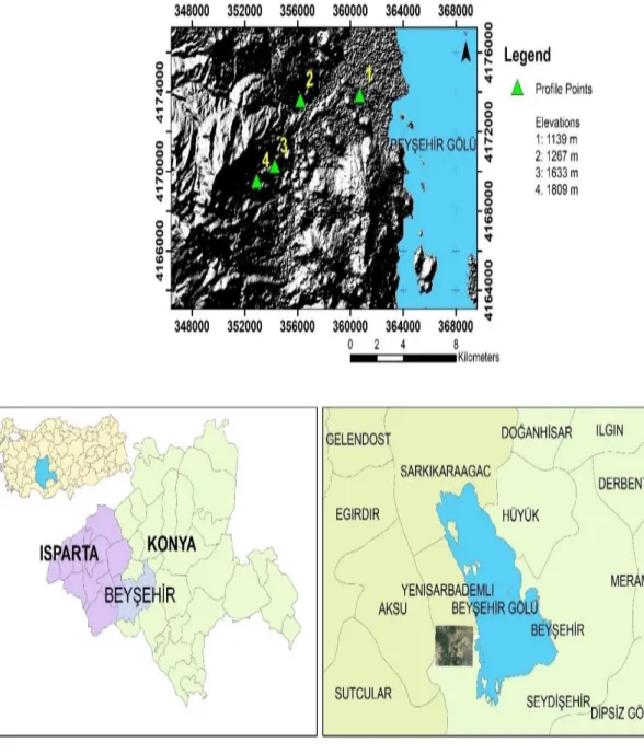
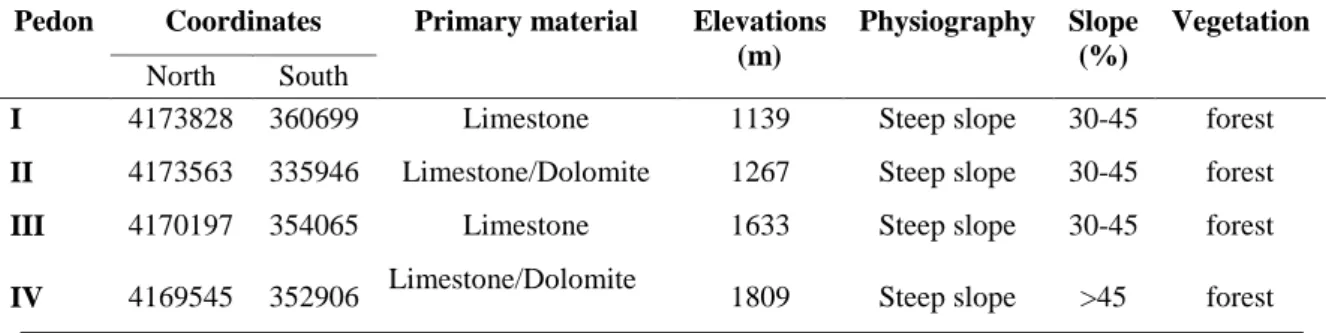
The study was carried out on the Anamas Mountain -Beyşehir in May 2018 and the area is located within the borders of the Lakes Region between Beyşehir (Konya) and Eğirdir (Isparta). The Anamas Mountains, which extend from northwest to southeast, descend into the plain with steepness from the west and southwest to Taurus Mountains. In this study, weathering rates of soils formation on the locations that have different altitudes and different rainfall as well as leaching regimes were used. Four different heights were selected within the study area and the used profiles under this study were dug at different heights. For this purpose, 4 profiles were dug between the elevations of 1139-1809 m (Figure 3.1). The study area is located between 37 ° 40 '- 37 ° 41' North latitude and 31° 19 '- 31 ° 26' East longitude. All profiles were steep and had forest vegetation, with profiles I and III formed on limostone, profile II and IV formed on limestone/dolomite primary material. Profile 4 had the highest slope (> 45) while other profiles had a slope of 30-45.
3.1.2. Climate
Elevation is an important factor affecting the climate. Turkey, is a country characterized by different elevation. Regardless of the type of climate, climatic features in mountainous areas, especially high mountainous regions, vary widely according to their environment. It is known that the amount of precipitation increases with increasing of elevation. Therefore, there are no definite values of the differences that may occur in precipitation due to the elevation. Meteorological stations are also needed in mountainous areas in order to reveal the characteristics of this climate type. However, for the time being, it is not possible to obtain healthy data from the higher parts of the mountainous areas. Therefore, there are no exact values of the differences that may occur in precipitation due to elevation (Şahin, 2005).
Figure 3.1. This study examined an elevational transect of four well-drained soils on the Anamas Mountains, Turkey
Precipitation changes vary in different areas of the world and also vary between seasons (Sarı, 2009). The change in precipitation rates in the Alps varies between 66 and 26 mm in altitude every 100 meters in winter. In the summer, the rate is between 40–30 mm, while the altitude is 100 meters (Sevruk and Nevenic, 1998). Researchers show that the highest level of precipitation in the Himalayas varies between 1600–2200 meters depending on the viewing conditions, indicating that after this level the precipitation rate decreases after 4000 m (Singh et al., 1995). In the Atlas Mountains,
the precipitation rate is 900 mm at the altitude of 2000–2500 meters. It was stated that it falls to 400 mm at 4000 meters and the rainfall rate decreases after 1800 meters altitude in the Taurus Mountains (Akman, 1990). Turkey has very few places in the high mountain station of 1877 m in Uludağ Summit station and 100m of the precipitation rate in Bursa station that increased in an uniform period and Bursa 673.3 mm rainfall Uludağ Summit station 1453.3 is determined that MCC reached. According to the altitude, the precipitation rate has increased about 2.2 times of 1777 m. As a result, this case shows that the lowest rainfall rates of up to 2000 m increase in precipitation in Turkey (Türkel, 2017).
The calculation method used to determine the changes due to the elevation of precipitation was the formula developed by Schreiber which is recommended by bioclimatic as well as physical geography workers (Yılmaz and Çiçek, 2016):
Ph = P0 +(54 h).
Where, Ph the amount of rainfall found at a certain point in a given elevation (mm),
P0 is total rainfall of a station compared to rainfall value and elevation (mm) h= Ph and P0 is the differences in elevation (hectometer).
If the area where the precipitation is to be determined is lower than the station where the precipitation and elevation is known, the process of subtraction is performed in the formula. Considering the elevation difference between the station and rainfall every 100 meters is 54 mm/m2 rainfalls was recalculated by increasing the sampling point (if the sampling point was lower than the nearby meteorological station).
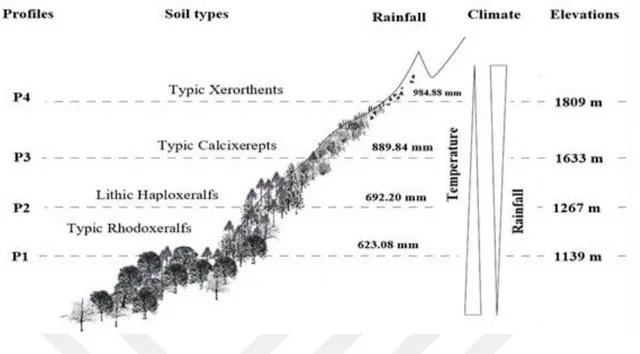
In this study, the precipitation of the profile points was determined by using Schreiber formula. The elevation of the meteorological station, which was measured for Beyşehir, was taken as 997.0 m. The distance between the study area and the meteorological station is 54.12 kilometers. The calculated rainfall amounts of the profiles were 623.08 mm for PI, 692.2 mm for PII, 889.84 mm for PIII, and 984.88 mm for PIV (Figure 3.2).
Figure 3.2. The amount of rainfall and the location of soil profiles during along altitudinal transect in mountain in Anamas.
According to the meteorological station data in the region, the average annual precipitation from 1960 to 2017 was 546.4 mm/m2, the annual evaporation was 1248.1 mm, the average annual temperature was 12.1 ºC, and the average soil temperature in 50 cm was 14.6 ºC (Table3.1). According to the prepared rainfall-evaporation-temperature diagrams (Figure 3.3) because of these data, the temperature regime of the region is mesic and the moisture regime is xeric (USDA, 2014).
Table 3.1. Annual average climate data of the meteorology Beyşehir (1960-2017).
Meteorological Elements Months J F M A M J J A S O N D Annual Average Temperature (Co) 1.8 2.9 6.2 10.6 15.2 19.7 23.3 23.0 18.7 13.2 7.5 3.4 12.1 Average Rainfall (mm) 75.2 63.0 55.7 54.8 54.0 30.6 16.3 13.5 17.1 38.6 45.8 81.8 546.4 Evaporation (mm) --- --- 14.6 108.7 156.4 204.3 252.3 232.5 168.8 92.9 22.1 --- 1248.1 Average soil temperature (50 cm) 4.9 4.8 7.1 11.0 15.8 20.8 24.9 25.8 23.1 17.9 11.9 7.2 14.6
Figure 3.3. Temperature Regimes and Moisture regimes of the working area soils.
3.1.3. Geology
The Anamas Mountains are generally composed of Jurassic-Cretaceous aged limestones in the second time. The Triassic sandstone, claystone and conglomerates and the Triassic limestones, dolomites and bauxite are observed at the foot of the Anamas Mountains. These bauxites are named as "ferrous bauxite". They also state that ferrous bauxites are extremely siliceous. In addition, it is overwhelmingly overlain by the Middle Eocene aged flysch character shady formation consisting of sandstone, siltstone and shale lithology. After the Middle Eocene, the settlements of Kızıldağ Ophiolites and other allochthonous units are observed. Upper Miocene-Pliocene formation, consisting of sandstone, claystone, marl and abundant limestones, which outcrops in the northern parts of Yenicekale, unconformably covers the lower units. The Upper Cretaceous aged curves formation, composed of volcanic rock, serpentinite, limestone, sandstone, siltstone, claystone and blocks on the ophiolites, and the Upper Neogene aged Deliktaş formation made of massive recrystallized limestones form the local allochtone units in the region. The alluvium and slope debris consisted of loosely attached or unenhanced clayey, silty sand, gravel and blocks belonging to rock units of different origin. The slope debris consists of material derived mainly from this unit along the contacts of Kızıldağ Ophiolites (Elitok, 2000; Robertson et al., 2003; Elitok and Drüppel, 2008). Various melting, decomposition, transport and accumulation and alluvium formations are still continuing in the region (Figure 3.4) (Arık et al., 2010). The rock variety of Anamas Mountains have been an important factor in the soil diversity. It is known that after the climate, the soil factors are effective in the growth of plants. The diversity of
rocks in the region has been influential in the formation of fertile agricultural lands (Özçelik, 2017). The high content of dolomites in the area of Anamas Mountain, which is generally composed of dolomitic limestones, plays a major role (Sağdıc and Bozyiğit, 2009). It is known that the rock variety is effective in the chemical composition of the water. There are underground lakes in Anamas mountains. The rivers that come out of the mountain go out with the increase of the water level there, decrease and increase and because it is the highest mountain and big in the region, it receives the highest rainfall and the rain decline in time. Beyşehir Lake and Eğirdir Lake's water resources from the bottom of this mountain is the extensions of the mass of water to the earth (Özçelik, 2017).
3.1.4. Vegetation
The region where Mount Anamas is located contains a diversity of vegetation and animal. Since the region is found between Central Anatolia and the Mediterranean, flora and vegetation show the features of the Mediterranean regions. The rock variety of Anamas Mountains has been an important indicator in the soil diversity of agricultural areas. It is known that after the climate, the soil factors are effective in the plant development, and is the first factor in some other plants. It is known that the rock variety is effective in the chemical composition of the water. There are underground lakes in Anamas mountains. The rivers that originate from the mountain get out with the increase of the water level. It receives the highest rainfall and these rain declines in time. Beyşehir Lake and Eğirdir Lake's water resources from the bottom of this mountain is the extensions of the mass of water to the earth. This wet and damp structure has been influential in the creation of wetlands, meadows and marshes around the mountain. It was chosen as one of Turkey’s 122 important Plant Areas. At the same time, it is one of important natural fields (Ozhatay et al., 2005; Eken et al., 2006).
This mountain is very beneficial for local farming. It is known that the plant geography, ecological conditions and floristic structure of the mountains are important in the choice of the plant to be cultivated. lake District is the center of rose and fruit production in Turkey. More than 50 % of the fruit trees in Turkey belong to the family of roses. Thanks to Anamas Mountains. Almost all of the fruit trees have a few wild forms in this mountain flora. There is almost 60 rose genotype belonging to 12 species in the mountain. Origanum minutiflorum is one of endemic species of the region. It is a genetic center for the rose genus. It is the most important of Turkey's exports. The volatile oil content is approximately 3% and the use of oil components is very convenient. Turkey's export is the most important. The volatile oil content is approximately 3% and the use of oil components is very convenient. This path should be made for economic benefit (Özçelik et al., 2012; Özçelik, 2013).
Some plants that grow naturally in the Anamas Mountains and have high economic substance: Mushrooms, cover plant taxa, ornamental plants, food plants, wild fruit trees, forest trees, fruit (apples, cherries, apricots, strawberries, quince, new world, Mediterranean / pearl, pear, hawthorn, etc.) (Özçelik, 2017).
3.2. Methods
3.2.1. Determination of soil profiles
In the Anamas mountains (Beyşehir-Konya), a sequence of four profiles was determined along an altitudinal transect ranging from 1139 to 1809 m. Soil profiles with different elevations, soils developed on locations with different rainfall and leaching regimes were examined. In the light of the data obtained, a total of 4 profiles were opened in the study area. Soil profiles were assumed to represent elevated regions. The geographical elevations and coordinates of each profile were used with the GPS device.
3.2.2. Soil sampling
Soils were described in the field for morphological properties of these four profiles and identified, 10% HCl solution, wide surface knife, pure water, Japanese color scale (Oyama and Takehara, 1967) and profile identification card were used. The definition and nomenclature of horizons was made according to USDA, 2014. Profile descriptions were performed by genetic horizons according to standard procedures (USDA, 2014), including moist and dry color, texture, structure, consistency and roots. It is defined in the characteristics of environmental factors such as elevation, degree of slope and vegetation type. Representative soil samples were collected from the genetic horizons of each pedon, disturbed and undisturbed soil samples were taken to the laboratory, then air-dried, gently crushed through a 2 mm sieve and subsequently used for the analysis of physical, chemical and mineralogical properties.
3.2.3. Chemical, physical, mineralogical and total element analysis methods
The soils were described in the field and samples were collected from each genetic horizon for laboratory analysis and the soil samples were air dried, gently crushed and passed through a 2 mm sieve to remove coarse particles. Air dried < 2 mm soil was used in the following analyzes:
pH: By saturated paste (Soil Survey Staff, 2004).