Recent discoveries (2015-2016) at Cadir Hoyuk on the north central plateau
48
0
0
Tam metin
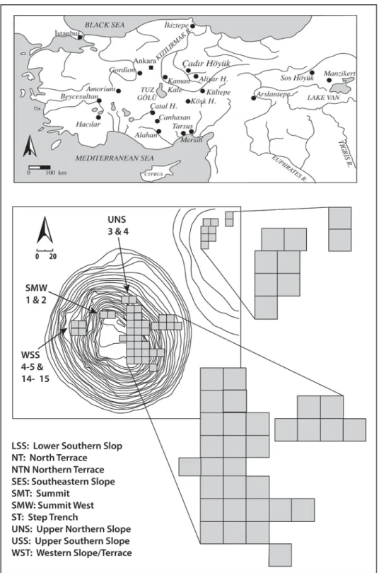
(2) 204. Sharon R. Steadman et al.. Fig. 1. Top: map of Turkey showing sites mentioned in the text. Bottom: topographic map of Çadır Höyük showing locations of open trenches..
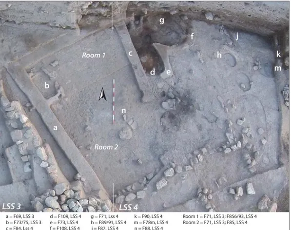
(3) Anatolica XLIII, 2017. 205. to 38 workmen on site, with excavations proceeding in at least fifteen 10 × 10 m trenches each season. In both seasons we investigated all periods represented at the site, from the Late Chalcolithic to the Byzantine, including the second millennium Hittite periods, the Iron Age, and the late first millennium Hellenistic period. It is our largest operations, the Late Chalcolithic and the Byzantine periods, that will form the majority of the discussion below, with some overview of the second millennium also included. Reports on our Iron Age and Hellenistic periods can be found in other recent reports (Serifoğlu et al. 2016; Steadman and McMahon 2017). The Çadır mound extends approximately 5 ha across a natural rise with another 5 ha of occupation on the north terrace. Foot reconnaissance in the areas north and northeast of the mound suggests that additional occupation, primarily in the Byzantine era, may have extended as far as another 10 ha beyond the mound. Trench areas are named for their geographical position on the mound (Fig. 1). In the 2015 and 2016 seasons we excavated trenches on the North Terrace, on the eastern, southern, and western slopes, and on the mound summit. Detailed summaries of previous years of work at Çadır can be found in earlier issues of this publication (Steadman et al. 2013, 2015) as well as other publications noted in the text below.. The “Lower Town” Late Chalcolithic Occupation At present there are ten trenches featuring Late Chalcolithic (fourth millennium BCE) occupation, all located on the southern slope of the mound. Five of these trenches are open to their full 10 × 10 m extent, and the other five range in size from 3 × 10 to 6 × 10 m. Excavations in seven of these trenches were carried out over the 2015-2016 seasons. Tentative phasing can be found in Table 1. We have developed new terminology to describe our Late Chalcolithic occupation which includes the “Lower” and “Upper” towns (town being a grand word to refer to what was a medium-sized village). Until the 2015 season, the two trenches further up the slope, USS 9-10 (see below), had demonstrated only Early Bronze occupation. There is now Late Chalcolithic occupation in this “Upper Town” area which rests roughly 1.5 m above the “Lower Town” area described in the following section. The Agglutinated Phase (Trenches SES 1-2 and LSS 5) The earliest building phase currently exposed at Çadır Höyük is a Late Chalcolithic complex spanning trenches SES 1 and LSS 5 (Fig. 2). Because the building is composed of small rectangular attached rooms arranged around a series of larger courtyards, the complex this period included: Jamie Allen, Nevra Arslan, Qizhen Xie, Joshua Cannon, Scott Coleman, Maira De sa Kaye, Jordan Dills, Alicia Hartley, George Heath-Whyte, Anna Gorall, Skye Jones, Veronica Kalas, Damjan Krsmanovic, Katarzyna Kuncewicz, Rolland Long, Serena Love, Orlene McIlfatrick, Erdoğan Ödük, Gonca Özger, Stephanie Offutt, Paige Paulsen, Susan Penacho, Gabrielle Peyton, Tamara Schlossenberg, Christoph Schmidhuber, Mark Sickle, Kennedy Smith, Kristen Squires, Michele Thomas, Joseph Wolter, Natalie Yeagley, and Chi Zhang. We would also like to thank the following institutions for financial and administrative support of the Çadır Höyük excavations: the National Science Foundation (BCS #1311511), the Social Sciences and Humanities Research Council of Canada (Insight Grant 435-2014-0944), Hood College, Memorial University of Newfoundland, SUNY Cortland, and the University of New Hampshire..
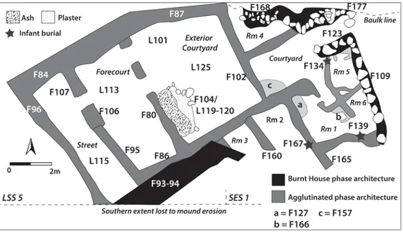
(4) 206. Sharon R. Steadman et al.. Trenches SES 1-2 & LSS 5 5th millennium Deep Sounding BCE (LSS 5) Agglutinated Subphase 1 Period. ca. 3700-3500 BCE. Trenches LSS 3-4. Trenches USS 9-10. Radiocarbon Date Beta #146710 4520-4480 BC (Cal BP 6670-6430). Beta #134069 3705-3620 BC (Cal BP 5655-5570). Agglutinated Subphase 2 Pre-Omphalos Building Phase. ca. 3500-3300 BCE. Burnt House Subphase 1. ca. 33003200/3100 BCE. Burnt House Subphase 2. ca. 3150-3100 Apsidal Phase ca. 3100-3000. Beta #159391 3650-3340 BC (Cal BP 5600-5290) Omphalos Building Phase. Beta #134070 3485-3475 BC (Cal BP 5435-5423) Beta #391309 Subphase 1 3335-3210 (Cal BP 5285-4970) Beta #363834 Subphase 2 3170-3160 (Cal BP 5120-5110) Beta #391304 Subphase 3 3140-3020 (Cal BP 5090-4970). Table 1. Prehistoric Phases and Subphases discussed in text.. is referred to as the “Agglutinated Phase.” This phase is architecturally distinct from the later Chalcolithic construction at Çadır, but shows similarities to roughly contemporary sites across the plateau (e.g., Canhasan 1 [French 1998], Hacılar II [Mellaart 1970]). Probably due to both changes in use as well as damage from fire, the Agglutinated structure was remodeled several times. In some cases, due to poor preservation and the interference of other, later structures, it is difficult to be certain which modifications belong to which remodel. In many cases, however, the sequence can be reconstructed with confidence. The Agglutinated structure spans several rebuildings featuring varying types of activity, ranging from domestic to industrial (likely cottage industry), and undergoes a very gradual abandonment. At present we can confidently articulate two building subphases, but as noted above, there were likely minute changes even within these, and further excavation in the coming seasons may elucidate additional building inter-phases. Agglutinated Subphase 1 The earliest building subphase currently exposed establishes a basic floor plan that persists until the destruction/abandonment of the building and influences later structures. The structure is at the edge of the mound and therefore of the settlement, and erosion on the slope of the mound has destroyed the southern edge of the complex in SES 1.2 Despite this, however, 2. “F” refers to “feature” and “L” to Locus in our excavation recording system..
(5) Anatolica XLIII, 2017. 207. Fig. 2. Plan of the Late Chalcolithic “Agglutinated Phase” in trenches SES 1-2 and LSS 5.. traces of a substantial mudbrick wall (SES 2, F11 [not shown in Fig. 2]) curving around the eastern edge of the complex suggest that there was an enclosure wall against which the agglutinated house might have been built. Later enclosure walls (LSS 5, F93-94), also damaged by slope wash, follow the same plan. It is entirely possible that a continuation of SES 2, F11 exists under the southern edge of F93 in LSS 5 which defines the earliest iteration of enclosure wall so far exposed on the southwestern side of the excavation area. The agglutinated structure is arranged to the south and east of a large square courtyard located at the western edge of the complex (labeled “Exterior Courtyard” in Fig. 2). The northern wall of this courtyard (F84 and 87, LSS 5), which incorporates large stones, is more than a meter thick and appears to be an external wall. This wall, which runs east under the north baulk and further west into the neighboring LSS 4 trench, was reused or rebuilt in later phases (in particular the Burnt House and Courtyard phase; Steadman et al. 2007, 2008), also likely as an external wall. The other courtyard walls (F86, 102) consist of mudbrick, very well preserved, about 50 cm wide; they could plausibly have borne the weight of a second story. The presence of a second level is also suggested by the fact that the small outer rooms are at a substantially lower level (approx. 50-70 cm) than the courtyards with which they share walls. This arrangement would have allowed the second story to stand fairly low relative to the courtyard level, and would have permitted traffic both above and below ground level, passing through the courtyards (Fig. 3). The burned collapse in LSS 5 (F81; see Fig. 4), discussed below in the Subphase 2 section, indicates that builders in this Agglutinated Phase used large, squared timbers laid horizontally. As yet, no doorways have been identified in any walls except the westernmost, external wall described below. Entrances to the lower rooms may have employed a combination of raised thresholds and ladders down from the courtyard level. Although these.
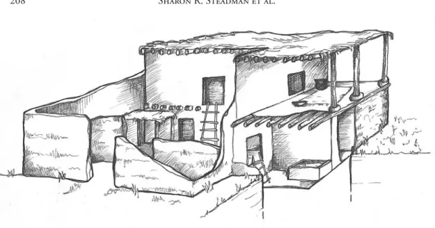
(6) 208. Sharon R. Steadman et al.. Fig. 3. Artistic rendering of what the Agglutinated architecture may have looked like (Laurel D. Hackley).. walls are maintained throughout the life of the Agglutinated structure, they are interrupted and overbuilt on the south by the stone enclosure wall LSS 5, F94, indicating a stratigraphic end-date for the use of the complex. To the west of this courtyard is a narrow corridor or forecourt (L113 in LSS 5) running the length of the structure (ca. 2 × 6 m). The original function of this space is not entirely understood as it has not been excavated to its lowest levels; however, in later iterations, it serves as an intermediary zone between the Agglutinated structure and a north-south street to the west. Very little pottery has been recovered from this forecourt area. Evidence from later phases suggests that the entrance to the complex (F106, LSS 5) was located in the wall between this forecourt/anteroom and the western street, and no other entrance has been identified for any period. The Exterior Courtyard itself (ca. 4.20 × 6 m), which has also not been excavated to its lowest levels, has nevertheless provided evidence for at least two, if not more, episodes of destructive fires, probably starting from the large hearth or oven, described more fully in the Subphase 2 section below. Fires emanating from this feature may have been the impetus for at least some of the remodeling of the Agglutinated complex. The large courtyard abuts a smaller space on its southeastern corner (labeled “Courtyard” on Fig. 2), which appears to have been an inner courtyard (ca. 2 × 3 m) allowing entrance to the other rooms of the structure. Three small (ca. 2 × 3 m) rooms (Rooms 1, 2, and 3) run along the south side of the complex, and are well preserved despite being eroded away on the south, at the edge of the mound. Room 4, near the northern extent of trench SES 1, is largely overbuilt by a later stone wall (SES 1, F168, F177) that has been left in place in order to preserve the stability of the northern baulk. Room 4, therefore, has not been fully excavated. The eastern side of the complex has been disturbed by later construction (SES 1, F123 and F109), which interrupts rooms 5 and 6, spaces that belong to the Agglutinated complex but are otherwise not securely phased..
(7) Anatolica XLIII, 2017. 209. Many of the major wall junctions in this earlier phase of construction incorporate the burial of a human infant in a large black-burnished pot (i.e. SES 1, F134 and F139 [a likely third, F99/L103 was excavated in 2012; see Steadman et al. 2015]). At least one of these burials was intentionally accompanied by ochre, animal bones, and lithics, and the burials are integral to the fabrication of the walls rather than inserted later. This makes these infant burials distinct from the many others in SES 1 and SES 2 that were inserted under floor surfaces and do not contain offerings. The earliest yet exposed Agglutinative complex Exterior Courtyard layer is found in LSS 5 (L125); it remained at the close of the 2016 season and will be investigated in 2017. The best preserved areas of this structure, then, and the ones most useful for parsing the life of the house, are the large and small courtyards and rooms 1, 2, and 3. Although the floor plan of the complex remains relatively stable, there are significant modifications over time in terms of built furniture and floor level. Agglutinated Subphase 2 There is substantial evidence for a series of modifications to the entire complex, difficult to phase individually due to the similarity of building materials and what may have been very short intervals between interventions. The majority of these modifications affect the interior built furniture and the curtain walls in the courtyard, leaving the load-bearing walls intact and continuing to respect the original floor plan of the structure. Alterations are made with sandy orange mudbricks that contrast with the smooth grey brick of the original construction. In many cases, the construction of bins and benches in this orange brick (e.g., SES 1, F127, F166) effectively consumes the available floor space of a room, perhaps indicating either a shift in storage methods or a transition of these rooms from living to storage space. Many of the bins were found to contain concentrations of burnt grain, suggesting that the spaces were used for domestic food storage.. Fig. 4. Photo of burned beams (F81) in LSS 5.. The large and small courtyards seem to have been little modified in this phase, except for a quarter-circular platform or step (SES 1, F157) built into the southwest corner of the small courtyard in the Subphase 2 sandy orange brick. Facing bricks on the abutting wall (SES 1, F102) suggest that this feature might have been associated with a raised threshold between the large.
(8) 210. Sharon R. Steadman et al.. and small courtyards, but this is uncertain. Apparent in this subphase is a large hearth or oven (LSS 5, F104/L119), built against the external western courtyard wall (F80). Extensive areas of phytoliths in LSS 5, L101, and in L120 in front of the hearth (LSS 5, F104) in the large courtyard indicate that the courtyard surface was covered with matting. There is very little plaster in this phase, except for a strip about 2 m wide that leads into the Exterior Courtyard from the presumed street entrance on the west. This stands in contrast to courtyard treatments in later phases when plastering seems to have been more of a norm. The Agglutinative Subphase 2 probably ended in the fire that left sooty ash in several places in the excavation area and baked the faces of some of the mudbrick walls, primarily in the south of SES 1. The effects of a destructive fire can certainly be observed in the large courtyard, where the charred collapse of the sunshade that employed the horizontal beams noted above (LSS 5, F81, Fig. 4), was left in situ and sealed under other debris before the next phase of construction. Burnt House Subphase I and Non-Domestic Building Perhaps in response to this fire, the entire complex was extensively rebuilt with increased use of stone, and the main part of the house was moved to the north of the area. This rebuilding corresponds to more global changes across southwest Asia, including the florescence of the Uruk system, which may have had some impact on the Çadır settlement (Steadman et al. ND). Even with this rebuilding, the major Agglutinated walls were respected, being rebuilt or, in many cases, reused. This would indicate that the inhabitants of the Burnt House took up residence shortly after the fire in the Agglutinated complex and may have even been the same group, who were taking advantage of an opportunity to update and improve a compromised structure. The large courtyard was plastered over, sealing the burnt debris underneath, and the hearth was moved away from the west wall and into the center of the courtyard (see reports on the Burnt House occupation: Steadman et al. 2007, 2008, 2013, 2015). The rest of the Agglutinated complex, which seems to be serving as auxiliary space to the new Burnt House, begins at this time to transition toward more industrial use. On the south side of the complex, the floors of rooms 2 and 3 were raised to courtyard level with a packing of large orange mudbricks, although square areas in the rooms were left at the original level, probably to make storage pits. The mudbricks used for packing are the same sandy orange as those used for modifications in the Agglutinated Subphase 2, but are significantly wider and flatter, making them easy to distinguish. The packing also seals a layer of ash, probably left from the earlier fire. The wall (SES 1, F160) between rooms 2 and 3 was cut down to the new floor level at the same time that the rooms were filled, and the surface between packing and wall stub was smoothed with a layer of orange clay plaster. The raising of the floor levels and demolition of walls suggests the loss of at least part of the roof or second story, and the conversion of this space from interior to exterior. It was also in this earliest Burnt House subphase that stone walls in SES 1, F123 and F109 (see Fig. 2), were constructed, demarcating the area of the Non-Domestic Building (Steadman and Hackley 2017). This carefully constructed building interrupts the eastern edge of the Agglutinated complex, and its floor level was lowered and leveled, removing any traces of.
(9) Anatolica XLIII, 2017. 211. the eastward continuation of Agglutinated walls. Within the building was an unusual symmetrical arrangement of three infant burials in large black-burnished jars similar in style to those built into the corners of the earliest Agglutinated walls, suggesting a continuity in the practice of infant burials associated with structures. The floor was laid over these jar burials, and each had a pot emplacement over it (see Steadman et al. 2015 and Steadman and McMahon 2015 for detailed discussion). Also recovered from this space were two figurines, a stone amulet (Steadman and McMahon 2017), and burnt clusters of wild and domestic grain, as well as a large quantity of fruitstand pottery. Burnt House Subphase 2 A hearth fire in the large courtyard once again damaged the main building, which was severely compromised and had to be shored up in several places, though it was occupied for at least a while after the fire (Steadman et al. 2013). Perhaps it was at this juncture that domestic activity shifted elsewhere and the courtyard area was given over to industrial or public use, indicated by large bread ovens and numerous small hearths. Considerable evidence points to pottery production on an extra-domestic scale, although it is unclear if this was occurring before or after the fire, or both (Steadman et al. 2013). The new enclosure wall (LSS 5, F93) was built over the brick packing of Room 2 and also Room 3 on the southern edge of the complex, perhaps to brace the architecture from erosion down the slope of the mound, clearly already destabilizing the area. This new enclosure wall disregards the plan of the Agglutinated building, indicating that it was no longer governing the spatial organization of this area. Close to the inside face of the new enclosure wall, two child burials were excavated in the Burnt House I brick packing. Unlike the earlier jar burials, these are simple inhumations that are inserted into the architecture. The cuts are visible and very lightly plastered. One of these burials (SES 1, F167) cuts both the brick packing in room 2 and the remains of the wall (SES 1, F165) bounding it to the east, indicating that the Agglutinated floor-plan was no longer relevant. Shortly after, the core of the settlement seems to have shifted elsewhere, and this southern area may have been left derelict. Apsidal Phase After a period of disuse, at least two horse-shoe shaped structures were dug into SES 1 and SES 2 (see Steadman et al. 2015 for detailed discussion). These were roughly 1.5 m across, with thin walls only one brick thick. It is hard to imagine them as dwellings, and given that the previous phase in this area was industrial it seems more likely that the apsidal buildings were related to storage or production. The more western of the apsidal buildings reused the foundations of Agglutinated room 1, indicating that parts of the earlier structure had survived the dereliction of the Burnt House and the subsequent disuse of the area. This phase gave way not long after to the Early Bronze I occupation which featured far flimsier one-roomed (domestic?) structures and open firepits (Steadman et al. 2007, 2008, ND)..
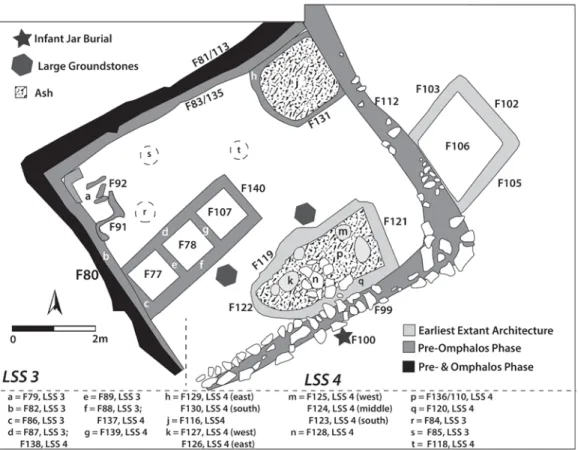
(10) 212. Sharon R. Steadman et al.. Fig. 5. Plan of the Late Chalcolithic Pre-Omphalos Building Phase in trenches LSS 3-4.. The Pre-/Omphalos Building Phases in Trenches LSS 3-4 Excavations continued in Trenches LSS 3 and LSS 4 in 2015 and 2016 to gather more information about the previous excavations in 2001 which had revealed the Omphalos Building. The preliminary results of the excavations have suggested the existence of two phases. The pre-Omphalos and the succeeding Omphalos phases are defined according to the architecture, pottery, and small finds. The Pre-Omphalos Building Phase The earliest exposed layer features a collection of largely non-domestic, mostly industrial, features contained within four walls that echo those of the Agglutinated complex to the west (see above). Our belief is that the features herein described are contemporary with the earlier Burnt House phase referred to above. At the end of the 2016 season in LSS 4, hints of earlier architecture appeared, suggesting that lying beneath the current exposure, we may have a more domestic “agglutinated” structure akin to that to the west. Some of the architecture described below likely belongs to this as yet unexcavated underlying structure, reused in the phase described here for non-domestic purposes..
(11) Anatolica XLIII, 2017. 213. The area in this Pre-Omphalos Building Phase is bounded by fairly substantial walls: F80-83 in LSS 3 and F99, F112, and 113/F135 in LSS 4 (Fig. 5). The external walls are ca. 35 cm wide, and the internal walls, perhaps supports or earlier iterations, are generally 20 cm thick. Stones are placed at some corners and as stabilizers along the walls. The most eastern F112 wall was particularly reinforced with additional stones and a rolled earth mixture within the mudbrick. A similar construction technique was used for LSS 4, F99 along the southern boundary. The features contained within this area are industrial in nature, but may be reusing earlier architecture that was originally domestic. One clearly industrial feature is the fire installation in LSS 4, located in the northeastern corner of this area. There were two building phases of this feature, which may have been a very large oven, or possibly a kiln, the earliest belonging to this “pre-Omphalos” phase and consisting of F116, and F129-133 in LSS 4. The walls of the kiln were ca. 15 cm wide, and between 1.5 and 1.9 m in length. The floor of the kiln (F133) was made of hard burnt, black colored loam, likely a mix of mud and clay, consisting of multi-layers that correspond to resurfacing. At the base of this floor was a layer of burnt clay that formed the bottom floor. To the south of this feature, still within the enclosed area, was an oval enclosure (F119122) 3.8 × 1.8 m in size, full of ash (F110); at the base of this was a floor built of layers of compacted brown earth (F136). This space seems to have functioned as both an ash dump from the kiln, as well as a place to store materials associated with ceramic production and to place newly fired pots. Built into the base (F136) were depressions roughly 15 cm deep (F123-127), topped by circular mudbrick platforms. Contained within these pits were materials associated with ceramic production, including quartz, sea shells, and lime balls, all used for clay temper in the Late Chalcolithic at Çadır. The mudbrick platforms may have also served as a place to rest newly-fired pots while they cooled (often referred to as “firedogs”). The uppermost layer, F110, consisted of an alternating layer of ash, mudbrick, and plaster traces. It is possible that F110 was deposited in this space by the users of a later kiln (F70, see below). Placed atop this deposit was a collection of paving stones (F128) that perhaps allowed users of this space to walk into it or across it. At present we believe the walls of this oval space correspond to earlier architecture, perhaps associated with an agglutinated domestic structure that exists below the extant level, likely consistent with the structure in SES 1 to the east. We hope that 2017 excavations will allow us to explore this possibility. A small structure northwest of the oval space proved to be a storage space with three small rooms (F77-78 in LSS 3, F107 in LSS 4), each measuring 1.23 × 1.26 m. The exterior walls of this structure (F86-89 in LSS 3 and F137-140 in LSS 4) measure 3.5 × 1.5 m and consisted of compact mudbrick. Inside the middle room two large quartz stones were found, probably associated with the creation of temper for clay; stones were also found in this room which may have been used for the same purpose (grit temper). Also recovered from this storage building were lithics, burnishing stones, polishing stones, a mace head, retouched blades, and obsidian and chert cores; clearly this space served as storage for materials associated with a variety of activities. At present it is unclear, but the walls of this space may rest on deeper walls associated with an earlier agglutinated structure; again, we hope that the 2017 season will reveal more about the origin of this small building..
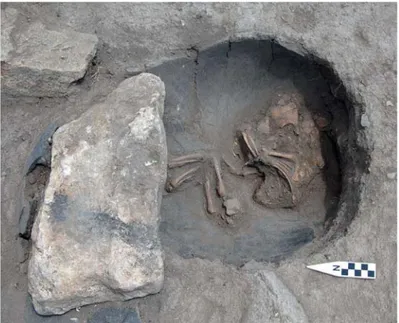
(12) 214. Sharon R. Steadman et al.. Three oval pits (F84-85 in LSS 3, F118 in LSS 4) were found in proximity to the storage rooms. Pit F85, 30 cm deep and measuring 0.42 × 0.44 cm, was covered with yellowish brown clay from top to bottom. It had a conical shape with a pointed base and may have served as a pot rest for a storage jar. Pit F84, barely 20 cm deep and measuring 0.68 × 0.60 cm, was located right next to the storage rooms. The bottom surface was covered with light yellowish brown clay. A number of clay chunks, two polishing stones, a burnishing stone, and some pottery were collected from this second pit. Pit F118 was shallow, only ca. 10 cm deep and measuring 0.40 × 0.40 cm; it was empty and may have also been for resting a large ceramic container. Two large grinding stones located near the storage rooms contribute to the interpretation that clay was processed in this courtyard. A once-rectangular storage bin (F79 [floor], F91-92 [walls]) was located in the northwest corner of the enclosed area. It measured 0.30 × 0.25 cm and was quite shallow (ca. 15 cm deep). It contained a large chunk of ochre (a material regularly used to decorate Late Chalcolithic ceramics), lime balls, quartz pieces, lithics, and pottery sherds. It seems to have been an additional storage space to the three-roomed structure to its south; it may have been built in a slightly different phase as well. As was the case to the east, infant burials were found associated with this complex. One (F100, Fig. 6) was placed under a large stone, next to the stone tumble (F128 in LSS 4) which was possibly providing an entrance to the courtyard complex or a passage across the dump area. A second jar burial was placed to the southeast of the wall complex. A final structure is found east of this complex. It is a semi-square structure (F102-106 in LSS 4), Fig. 6. Photo of the F100 infant jar burial in the Prewhose walls poke up above Omphalos Building Phase in trench LSS 4. what appears to be an exterior courtyard. It may be that this structure belongs to the earlier, as yet unexcavated, architectural phase preceding the one just described. We hope to have a better understanding of this structure, which rests just west of the street shown in Fig. 2, after our work in the coming season..
(13) Anatolica XLIII, 2017. 215. The Omphalos Building Phase The next (later) phase reflected a new layout (Fig. 7), primarily exposed in 2015. The area continued to demonstrate an industrial nature, dedicated to ceramic production, storage, and possibly ceramic distribution activities. This occupation described here is contemporary with the earlier and main Burnt House phases in the SES 1-2/LSS 5 trenches to the east (midto second half of the 4th millennium BCE). Located in the eastern half of LSS 3 and the western quadrant of LSS 4 was a room, later becoming two rooms, with a courtyard to the east. The 2015 excavations revealed the earliest iteration of the Omphalos Building first excavated in 2001 and reported on in many reviews of work at the site (Steadman et al. 2007, 2008, 2015). This earliest level of the Omphalos Building, oriented on an E-W axis, is a large space measuring 8.3 × 8.63 m, bounded by mudbrick walls once covered with plaster on the interior (F69 in LSS 3, F84 in LSS 4). These walls were ca. 50 cm thick and were built so that they encompassed the pre-existing walls from the earlier phase discussed above. It may have been divided into two use areas, but these are not separated by any partition wall. We detected slight differentiations in the artifact distribution and laying of the floors, and thus these areas were. Fig. 7. Photo of trenches LSS 3-4 showing the architecture in the Late Chalcolithic Omphalos Building Phase..
(14) 216. Sharon R. Steadman et al.. divided into separate rooms in our excavation strategy. Possibly they were separated by an organic divider no longer detectable. Room 1, the smaller room in the northern half of the space has a carefully-made floor (F70/74 in LSS 3 and F86/93 in LSS 4) consisting of compacted earth containing white plaster areas (suggesting the floor was once plastered). A storage area (F73/75) was built into this room, perhaps on the foundations of that found in the earlier phase discussed above. Several layers of compacted earth and plaster were detected, suggesting a renewal of the floor intermittently. The floors in Room 1 were almost entirely devoid of artifacts; it may have served as a storage area for organic materials, or perhaps a sleeping/resting space for those engaged in labors in the courtyard or in Room 2. Room 2, in the southern half of this area, (F71 in LSS 3, F85 in LSS 4) has two entrances into it, on the southern and eastern sides. It was in Room 2 that most of the artifacts were recovered from inside this earliest iteration of the Omphalos Building. Inside this room was a small bin, near the eastern entrance, from which a unique ceramic piece was recovered. Room 2 contained a variety of ceramic types including “fruitstands,” “Omphalos Bowls” (for which this building is named), stone tools, and ceramics with incised and relief decorations (different from the more standard black, buff, red, or orange burnished wares). Many of the recovered ceramic items showed traces of ochre decoration. There were almost no domestic materials recovered from this room, or the building as a whole, and no cooking facilities were discovered in the vicinity of the building. The building may have been associated with the distribution of ceramics, perhaps those produced in the kiln resting across the courtyard (see below). The most spectacular discovery from Room 2 came from the bin (F88) just inside the eastern doorway. Parts of a square vessel (with rounded edges), covered with relief decoration in the form of lozenges and incisions once completely infilled with white decoration, were recovered. Rising from the main body of the vessel was a delicately-wrought bull’s head (Fig. 8). There was no base to this vessel and so it cannot “contain” an item. Our assessment of this artifact is that it is an andiron, perhaps only for symbolic use. It resembles similar items found in eastern Anatolia and the Transcaucasus region, dating to the Late Chalcolithic and Early Bronze I periods (Kiguradze and Sagona 2003; Kelly-Buccellati 2004; Kohl 2007: 98-100; Palumbi and Chataigner 2014; Sagona 1998). Its presence at Çadır demonstrates interaction with these regions, or at the very least, emulation of interesting items observed through cultural transmission. The large courtyard east of the structure is contained entirely in Trench LSS 4. It features a kiln, pits, and the ash dump space on the southern side of the courtyard that was described above. The single-chambered updraft kiln (F71) was built near the eastern wall (F84) of the Omphalos Building and rested above the oven/kiln described above. The wall of the kiln (F108), the remains of what was once likely a dome, surrounded the baking chamber (F71) accessed by an entry space (F109), bounded by a wall/platform (F73). The baking chamber, measuring 2.38 (N-S) × 1.68 (E-W) was filled with a 5 cm thick collapsed burnt mudbrick layer, possibly the remains of the domed superstructure. Underlying this mudbrick was a ca. 9 cm thick burnt plaster layer underlined by a layer of pot sherds (F111; Fig. 9); beneath this was a pebbly mix that was likely laid to create a flat surface over the earlier fire installation described above..
(15) Anatolica XLIII, 2017. 217. Fig. 8. Photos of ceramic “box” (likely an andiron) with bull’s head and incised (once entirely white-filled) decoration from bin in trench LSS 3.. The F73 feature bounded the entry into the kiln and may have served to keep the heat contained. It was 1.54 m in length and ca. 30 cm wide, consisting of two layers of mudbricks connected by mud mortar. Laid over the mudbrick was approximately 8 cm of thick yellowish-brown clay; traces of plaster at the southern end suggest that the entire feature was once lime-plaster covered. The passage (F109) that F73 and F84 create (the entry into the kiln) is 3.25 × .93 m in size. The surface consists of burnt clay showing scorch marks. Surrounding the kiln, in both the courtyard and the top of a wall, were pits/depressions (visible in Fig. 7), ranging in depth from 5-18 cm; they were clay-lined and largely empty of finds. One pit located in the passage to the kiln was lined with clay and heavily burnt; its purpose is as yet undetermined. A pit in the eastern quarter of LSS 4, F89, was situated midway between the kiln and two ash pits (described below). Pit F89 had a carefully made flat mudbrick surface and side walls and was situated next to, or atop, a platform (F 91) consisting of smooth mudbrick slabs that ran between F89 and the ash pit (F87). A container/vessel may have once rested in F89 which held items associated with running the kiln or perhaps emptying the ash. The pit just to the south may have served a similar purpose..
(16) 218. Sharon R. Steadman et al.. Fig. 9. Photo of the lowest floor of the fire installation (kiln) in the Omphalos Building Phase of LSS 4.. The two ash pits that likely served as dumps for debris from the kiln are located in the northeast corner of Trench LSS 4. The F78 pit is circular and measures 1.30 × 1.26 m, and F87 measures 1.56 × .63 m; they are separated by a mudbrick platform (F90), perhaps to serve as a place to stand while emptying containers of ash. Besides ash, F87 produced burned bone, lithics, and three pieces of metal slag. This may suggest additional industrial activities in the courtyard, or simply that these pits were convenient for emptying trash from around the settlement. As noted above, some of the ash from this kiln may have ended up in the oval space to the south, but once it was filled workers seemed to have turned to these new locales east of the kiln. The Omphalos Building was renovated and slightly reorganized over at least two more phases of occupation, which included the creation of a bench and internal furniture, all excavated in 2001 and reported on in numerous publications (Gorny et al. 2002; Steadman 2007, 2008, 2013). The building fell out of use near the end of the fourth millennium when the main gate into the village was blocked, and the Burnt House to the east was also largely abandoned.. The “Upper Town” Late Chalcolithic Occupation Exposure of the Late Chalcolithic/Early Bronze I transitional period at Çadır Höyük centered on trenches USS 9 and USS 10, approximately 16 × 6 meters in size. Trenches USS 9 and USS 10 have been excavated since the 2012 season and will continue into the 2017 season. USS 9 was first excavated in 2000-2001 and reopened in 2012; USS 10 was opened in 2012 to allow for an extension of this area. The whole area was excavated to understand the transition between the Early Bronze I period and the Late Chalcolithic. As a note, all standing architecture and levels were cut in the southern edge of the trenches by the slope and slope.
(17) Anatolica XLIII, 2017. 219. wash, so that no walls or floor were complete or intact at the southern edges. During the 2016 excavation season, the architectural style and ceramics found in the USS 9-10 area were very similar to those from LSS 5 and SES 1 which lie to the south and approximately 1.5 below the currently exposed USS 9-10 occupation. Carbon dates are not yet available, but we believe the currently extant levels of USS 9-10 to be contemporaneous with the latest stages of occupation in the LSS and SES trenches. The Late Chalcolithic Occupation A total of three subphases of Late Chalcolithic occupation were excavated in the 2016 and 2015 seasons in these trenches. While there were noticeable changes between phases, continuity was also substantial. Stone and mudbrick walls were often reused in later phases, courtyard floors were replastered hundreds of times, and fire features were built in the same location numerous times. Subphase 1a-b The architecture in the earlier Subphase 1 (Fig. 10a) was split into two additional subphases (a and b), with minimal but notable changes. The architecture in USS 9-10, as exposed by the end of the 2016 season, centered around an open courtyard (Subphase 1a F97, USS 9, [F90 in later Subphase 1b]), flanked by a number of small rooms, likely used as workspaces. Two large parallel stone walls in USS 9, F92 to the east, and F67 to the west, were the center of this phase. Both walls began in the northern baulk, and continued into the slope wash to the south, so the complete length remains unknown. The walls appear to line up with a built mudbrick pathway running NW/SE. This lines up with the “street” shown on Fig. 2 and located in Trench LSS 5. Whether these are related, offering access from the lower town to this higher elevation of occupation is something to be investigated in future seasons. To the west of wall F92 is an open room (L128) containing a large round mudbrick firepit (F91) in the northern half of the room. The pathway, or courtyard, surface (F97) between these two walls contained dozens if not hundreds of white plaster layers visible in the northern section, with a depth of nearly a meter, indicating that the surface was replastered countless times. These surfaces yielded trash deposits of sherds and bone fragments, indicating that it was likely an open work area or heavily used walkway. East of wall F67 were a number of smaller rooms. A stone wall, F94 in USS 9, corners with F67, creating a room (F95) featuring a plaster/clay floor that extends into the northern baulk. On the south side of wall F94 was another room (Subphase 1a F93; this becomes F87 in Subphase 1b) which contained a small, but well made rectangular bin (F89) filled with ash, but otherwise clean. The F93 floor consisted of dark brown clay, sloping downward from north to south. Only a rather small amount of pottery and bone were found inside either room. The Subphase 1b F87 floor yielded a perforated ceramic disk and ceramic stopper. The fill between the F93 and F87 was made up of many dense layers of clay flooring, showing that there was a slow, continuous use and reuse of this area..
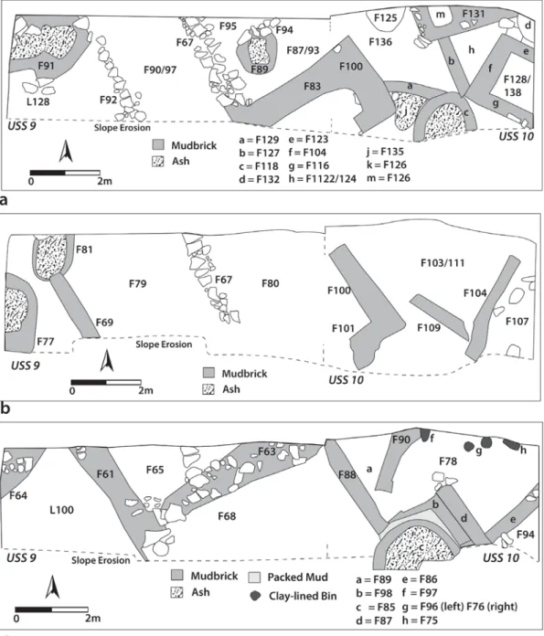
(18) 220. Sharon R. Steadman et al.. Fig. 10 (a-c). Plans of three subphases in trenches USS 9-10..
(19) Anatolica XLIII, 2017. 221. Further east, numerous walls created a series of small rooms in Trench USS 10. All the rooms had sloped floors consisting of dark clay, with numerous mudbrick platforms, bins, and fire features throughout. The slope of the floors, often quite extreme, was one of the more puzzling aspects in the excavations of this area. The floor slopes were consistently maintained to the Early Bronze Age occupation. However, it was not uncommon for the slope of the floors to change angle in different phases, causing some of the later phases to cut into the earlier floors during construction, and making interpretation of these construction phases quite challenging. The one substantial wall in this Subphase, F83 in USS 9 and F100 in USS 10 (the southern extents of which are lost to the mound slope), juts into an oddly-shaped room represented by floor F136 in USS 10. This floor was unusual in that it was flat, consisting of hardpacked black clay (cut by a later construction of a sloped floor described below). Contained within this room were a number of mudbrick platforms. The first was circular (F125 in USS 10), with a similar platform (F132) located in the northeast corner of the trench. A third was a larger rectangular platform (F131), with a rectangular clay-lined bin (F126), dug into the western edge. A baked clay loomweight and ceramic fragments came from this bin. This room was bounded in the south by a small curved mudbrick wall (F129 in USS 10) and an equally small wall to the east (F127), both of which were cut or reused by Subphase 1b features. East of wall F127 was a triangular bin (F124 in Subphase 1a, F122 in Subphase 1b) with a sloped hardpacked clay floor with signs of white plaster, under layers of laminated plaster floors. The floor sloped downward from north to south, with the floor preserved down the length of the feature. The matrix in this area, especially near platform F132, contained unfired clay with small pebble inclusions, suggesting that ceramic production was one of the activities carried out here. A rectangular room in the eastern half of USS 10 (F138 in Subphase 1a, F128 in Subphase 1b; surrounded by mudbrick walls F104, 116, 123) also featured a largely flat floor with only a slight slope from north to south. The floor consisted of plaster layers; the norm in this area is for white plastering to be used for exterior surfaces and packed green clay for interior surfaces. However, the look of this room suggests it might have been an interior space. At the southern edge of this entire USS 10 complex was a large circular fire installation (F118), possibly a kiln or oven. The fire installation was the fifth in a series of fire features all located in roughly the same place, discussed more thoroughly below. This iteration was a round, well-fired mudbrick domed structure, though the entire southern half has been lost to slope wash. F118 was in use during both subphases, though in Subphase 1a, a large bin, F135, was built on the west side of it. F135 was a large, roughly parabola shaped clay-lined bin which may have functioned as an ash dump for F118. Subphase 2 In this later subphase (Fig. 10b) there was only moderate change in the architectural layout. The most significant change was that the USS 9 floors F93 and F95 fell out of use, and wall F83 and bin F87 were destroyed, thereby creating an open courtyard like that to the west of wall F67. However, F67 was truncated on its southern end to allow for a doorway between the two open areas. The previous F92 wall was encompassed by a later and smaller mudbrick wall (F69) that featured a doorway to the north. The courtyard/pathway to the west in Trench.
(20) 222. Sharon R. Steadman et al.. USS 9 is F79 (also F75), and that to the west of F67 is F80 (also F74). The courtyards were in use for a considerable amount of time, with at least 30 cm of white plastered floor layers preserved. Material found on the surface of these courtyards included remnants of pottery and stone tool production and copper smelting, suggesting that they functioned as open-air workspaces. At the western edge of USS 9 was a room with poorly-preserved walls, containing a circular fire feature (F77) resting near and partially atop the earlier F91 from Subphase 1. Also in this area, above F91, was an ephemeral fire installation (F81) which may have been the upper remains of F91. East of the courtyards were the now typical series of small rooms built directly above those described above in the Subphase 1 section. These more westerly rooms were better preserved, built directly over the rooms in USS 10 described previously. A northern doorway from courtyard F80 in USS 9 led to a large, roughly rectangular room in USS 10 built in an earlier (F111) and later (F103) phase. This area was bounded by mudbrick walls, F104 and F109. The floor was significantly sloped and coated in green clay (similar to the remnants that survived in the poorly preserved USS 9 western rooms). All the floors in this area were sloped, often to a significant degree, frequently cutting into the floors of the earlier phase. At the far eastern edge of USS 10 is a floor (F107) on/in which F104 rests; stones, perhaps from a feature to the east, had fallen onto this relatively flat yellow plaster floor. We have interpreted F103/111 as subfloors, covered by a working surface consisting of wood and/or reinforced matting. This “upper” organic flooring would create a clean, dry storage area underneath. Material remains on F103/111 suggest that wet clay, for ceramic production, may have been stored here. To the south of this complex was a large oven or kiln (F99), constructed with mudbrick and micaceous clay (the latter also clay that is used to make Late Chalcolithic ceramics). This fire installation is directly atop F118, described above. Two smaller fire installations, perhaps for cooking or heating the area (or for open firing of vessels), were found in this complex. Although this area appears entirely industrial, an infant jar burial (F92) was located under the F103 floor. Infant burials in later phases were also found in this area (Steadman et al. 2015). The walls in this phase are consistently thick, between 40-50 cm in width, more than adequate to support a roof and possibly rooftop activities. We believe that Subphases 1-2 date to the very late fourth millennium, which would be contemporary with the last stages of the Burnt House and Omphalos Building in the “Lower Town” trenches (LSS 3-5 and SES 1-2). The two levels of Late Chalcolithic architecture would have created a set of terraced levels up the southern slope of the mound. Inhabitants might have used pathways or ladders to ascend from lower to higher architecture and courtyards. Terracing from the Late Chalcolithic and Early Bronze periods are known from other contemporaneous Anatolian settlements, including Yumuktepe/Mersin (Caneva 2000), Tepecik/Makaraz Tepe (Esin 2001), Kuruçay Höyük (Duru 1994), and possibly Tilbeshar Höyük (Kepinski 2007), though none with the architectural layout theorized at Çadır Höyük. We hope to investigate the settlement structure more rigorously in the coming seasons..
(21) Anatolica XLIII, 2017. 223. Subphase 3 This latest Late Chalcolithic subphase (Fig. 10c) can be considered “transitional” in that it likely dates to the very end of the fourth millennium, as it turns to the early third millennium Early Bronze Age. Interestingly, from this Subphase and into the Early Bronze Age, the architecture generally becomes more substantial, suggesting that this area of the settlement may have increased in importance. Subphase 3 is likely contemporary with the “Apsidal Phase” in SES 1/LSS 5 to the south, when the “Lower Town” experiences a significant change in architecture and usage, discussed in other reports (Steadman et al. 2015, ND; Steadman and McMahon 2015). Residents used the previously existing F67 wall in USS 9 to create a foundation for a wider mudbrick wall (F63), which connected to an equally substantial wall (F61) extending to the northeast. These walls created a large room with a plastered floor (F65). To the west was a large open space (L100), bounded on the west by another substantial wall (F64). Another open space, F68, was located south of wall F63. Neither of these open spaces showed evidence of plastering and may have simply served as open spaces or light work areas; few artifacts were recovered from these contexts. The eastern area, primarily in USS 10, continues to feature walls and sloping floors. In some cases walls in this Subphase (F86-88, and F98) partially or entirely reused preexisting walls from Subphase 2. The floor within these walls, F78/F89, still sloped and still used green clay as flooring material; we speculate that a “false floor” of wood/matting rested above F78/ F89 to continue creating the underlying storage area. Wall F90, protruding into the space, may have been a bench or flooring support; it effectively turned F89 into a small storage area. Now missing are the mudbrick platforms of the previous Subphase, replaced instead by a small number of irregularly shaped clay-lined bins or pot emplacements (USS 10, F75-76, F96-97). A new kiln/oven, F85, was built directly over its Subphase 2 F99 predecessor. This Subphase 3 iteration is much larger in area, but lacks the mica-rich clay. All areas were relatively clean, but finds suggest that this remained an industrial space, with activities including ceramic production and firing, and copper smelting. Early Bronze I Period Phases The Early Bronze I occupational levels in USS 9-10 were excavated in the seasons prior to 2015 and are reported on in several publications (Steadman et al. 2013, 2015). Only a brief overview, connecting the EB architecture to that described above, is offered here. In the early decades of the late fourth millennium and into the early third, wall F63 was significantly augmented, becoming wider and stronger, to the extent that we termed it a “fortification wall” during the years of excavation of this more substantial feature (2013-2014); this larger version was designated F45 in USS 9. The F45 wall was very well constructed, with five rows of mudbricks creating a 2 m wide wall, with a foundation made of large stones and boulders. The exterior of the wall was coated in the same green clay known from the floors and walls of the earlier phases. This F45 wall extended for 8.3 m across both trenches. The wall continued across the entire exposed area, though the southern edge was destroyed by slope wash..
(22) 224. Sharon R. Steadman et al.. Wall F45/F63 connects to, or is part of, a substantial fortification system dating to the second millennium BCE Hittite occupation of Çadır; this even more substantial stone and mudbrick Hittite wall, present in the eastern Step Trenches (Şerifoğlu 2014, 2015; Steadman et al. 2013, 2015; Steadman and McMahon 2015), as well as emerging in USS 4 just north and above USS 9, used some of the Early Bronze F45 wall to serve as a foundation. It will be some seasons before USS 4 reaches depths sufficient for us to understand the relationship between these two fortification/substantial wall systems. Just to the south of F45, in Trench USS 10, the area continued to feature a series of rooms and storage bins with similar layouts to previous periods/subphases (Steadman et al. 2015: Fig. 5). Floors continued to be sloped and built with green clay. A fourth-generation fire installation (F69) was built atop its predecessors, though it was somewhat smaller in size. It appears that this area, though now located “outside” the town perimeter defined by F45, continued to function as an industrial work area. The Prehistoric Phases at Çadır As already noted, the Early Bronze substantial perimeter wall was used as a foundation in the Late Bronze Age for the construction of an additional wall (now under excavation in USS 4). This wall, therefore, stood as some type of vanguard for the site spanning the Bronze Age centuries. In the Late Chalcolithic, the perimeter wall, noted as the “Enclosure Wall” in previous reports (Steadman et al 2007, 2008, 2013), encircled the “Lower Town.” At the turn of the millennium, within a century before or after this time, the settlement seems to have contracted so that the majority of the occupation moved up the mound, though some occupants continued to use the area that was once the thriving Lower Town. In the Early Bronze period this Lower Town area was used by people building small single-roomed structures with small firepits scattered in open areas; the Omphalos Building and Burnt House were abandoned and destroyed, and the Enclosure Wall gate had been blocked. What had been, in the previous millennium, a Lower Town with a vibrant area with public and substantial architecture, became an area existing outside the main settlement, perhaps devoted to storage, temporary or marginal housing, and a very different lifestyle than had been enjoyed in the Late Chalcolithic.. The Second Millennium on the Eastern and Upper Southern Slopes The majority of our 2015-2016 work on the eastern slope took place in trenches ST 7 and ST 2. A concerted effort in the 2015 season was devoted to removing a significant (1.5 × 6 m) pedestal along the western baulk in ST 2. This was left in place to support an Iron Age wall excavated in seasons past. However, by 2015 the wall was in partial collapse, and it was determined that removal of it and the pedestal was the best course of action. The removal of this narrow ledge (Fig. 11) offered us the chance to check our theories concerning the construction sequences behind the two building phases of the eastern slope Hittite fortification walls (Steadman et al. 2013, 2015; Steadman and McMahon 2015). The 2015 excavations confirmed the two major building phases we have described in the past: an upper later phase constructed upon an intentionally laid terrace support which covers and serves to level an earlier lower.
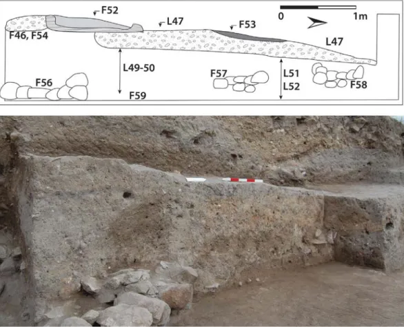
(23) Anatolica XLIII, 2017. 225. phase. This upper phase likely dates to the second half of the second millennium BCE and is contemporary with the largest and latest stone and mudbrick (4 m wide) Hittite casemate wall encompassing the settlement on the eastern slope. In the pedestal, a hard-packed mudbrick surface (L46-47) sloped upward from north to south (the same sloping direction of the Hittite fortification wall), and would have met with wall F11 in ST 7 (the wall belonging to one of the rooms described below; not pictured here). Associated with this exterior area is an oven (F52) resting on a plaster surface (F54) at the base of L46, and a nearby ash lens (F53). It appears, then, that the area in ST 2 remained a type of courtyard and open area throughout the second millennium, in both the earlier and later phases. Below this was a mixture of ephemeral layers, some plastered, along with a thick (over 50 cm, L49-52) layer of mudbrick tumble likely resulting from the substantial structure described below. The mudbrick tumble had been packed down in order to create the “terrace” on which the later second millennium phase architecture was constructed, including surface L47. The lower, earlier phase, which is currently exposed in both ST 2 and ST 7, is contemporary with an earlier, smaller, Hittite casemate wall (2 m wide) directly underneath its larger and later iteration. The earliest surface exposed here is F59, which is contiguous with wall F56 and with F76 (the large building discussed below) in ST 7.. Fig. 11. Top: section drawing (west section) of “ledge” excavated in ST 2 in 2015; bottom: photo of same ST 2 ledge looking northwest..
(24) 226. Sharon R. Steadman et al.. The 2015 excavations in ST 7 removed two rooms, exposed in previous seasons, that belonged to the later occupational phase. These two rooms rested on an intentionally laid terrace consisting of L86, L105, and L107-8 (which equal L49-52 in the ST 2 ledge). Cut into these were mudbrick steps that allowed residents in these rooms to descend down to what may have been open courtyards just inside the later Hittite casemate wall (see Steadman and McMahon 2017 for detailed description). Lying beneath these rooms and the terrace pedestal on which they had been built were the foundations of a substantial second millennium building, the mudbrick wall superstructure of which likely formed some of the terrace fill in both ST 7 and ST 2 (Fig. 12). What is extant in Trench ST 7, we believe, is the eastern wall and forecourt of this structure. The building is at least 6 m wide on the N/S axis, but its length is impossible to estimate given that the structure extends westward into the mound. Two courtyards fronted this eastern end of the structure; the wall foundation of the structure itself (F76) consists of a mixture of mud and clay packed around wooden beams laid in a lattice pattern (Fig. 12) supporting a mudbrick superstructure. This construction technique has been observed at other second millennium sites such as Maşat Höyük (Özgüç 1982), Oymaağaç Höyük (Czichon et al. 2011), and Kuşaklı-Sarissa (Müller-Karpe 1998, 2000; and see Beckman 2010 and Mielke 2009 on Hittite construction techniques).. Fig. 12: Aerial view of trench ST 2 and 7 showing areas of excavation; top right, sketch of remains of F76 area “lattice” consisting of clay, wood, and rocks (based on sketch provided by S. Spagni)..
(25) Anatolica XLIII, 2017. 227. Fig. 13. Left: stratigraphically lower infant burial associated with building (burial is F99, cut is F98, matrix is L122, cap is F97); Right: upper infant burial placed within terrace fill (burial is F84, cut is F83, within matrix L110).. During the 2016 season two infant burials were found in Trench ST 7. The stratigraphically lower burial (F 97-99 and L122) was located at the southeastern corner of the large structure’s foundations, emplaced within the clay and mud that formed the foundation matrix (Fig. 13). Approximately 1.10 m higher was a second, later, infant burial (F83-84; Fig. 13) found within the terracing matrix (L110). The earlier burial may have been meant as a foundation deposit for the large Hittite-period building; a very fine ground stone tri-footed bowl was also found buried next to this structure (Steadman and McMahon 2017). The later burial may have been more closely associated with the construction of the terrace above this building, upon which the later phase of occupation was eventually built (the “two rooms” mentioned above). While there have been numerous infant burials found associated with our Late Chalcolithic and Early Bronze Age occupation, these are the first two found associated with second millennium architecture at Çadır. Unfortunately the purpose of this large building is at present unknown to us. It does, however, suggest a substantial Hittite presence at the site dating to the mid-second millennium BCE. Excavations proceeded in USS 4 on the Upper Southern Slope in 2015 and 2016. As always, the complicated stratigraphy in this trench makes interpretation a challenge. Radiocarbon dates, and the ceramic assemblage, indicate to us that excavations have proceeded below the Early Iron Age levels into the Late Bronze Age, likely during, or just after, the collapse of the Hittite Empire. The last two seasons of work have revealed a complicated collection of mudbrick remains, some of which began to resolve themselves into two large mudbrick walls running more or less east-west across the trench. It is possible that these were a continuation of the large stone-built casemate wall present in the eastern slope Step Trench, built only with mudbrick on the southern side. The tops of these walls have been carved up into rooms and work spaces, making the interpretation of their original function difficult. We hope that the 2017 and 2018 seasons will allow us a better opportunity to interpret the walls and the area they enclosed..
(26) 228. Sharon R. Steadman et al.. The Middle Bronze and Iron Ages on the Western Slope Excavations at the western side of the mound, which was not investigated before, started in 2015 with the hope of revealing the settlement history on this part of the höyük. The excavations were conducted by a team of scholars and students from Bitlis Eren University, University College London, Bilkent University, University of Cambridge, and Çanakkale Onsekiz Mart University. Our team worked in three trenches (WSS 14, WSS 15, and WSS 5) although not in their entirety, and only excavated for two weeks each season, working for a month in total. Valuable information concerning the Iron and Bronze Age levels at Çadır Höyük was gathered by the excavators in this limited period, which can be seen as a successful start to the western slope operation.. Fig. 14. Plan of trenches WSS 14-15 showing the Middle/Late Iron Age wall and related features discussed in the text (drawing by Nazlı Evrim Şerifoğlu).. The excavations in this area focused on the lower reaches of the slope, with the hope of studying the connection between the mound with the fields immediately below. The excavations started in 10 × 10 m trenches WSS 15 and WSS 5, with the former located just above the latter. Our team came across a stratum of pebbles and river stones of various sizes just below a hard-packed greyish yellow layer in the eastern half of WSS 15, which we first thought to be a Byzantine architectural feature of some sort; we began removing it to see what might lie below. This operation continued until the end of the 2015 season, but we were unsuccessful in removing the whole pebbly riverbed soil stratum. However, we could at least identify this layer as a huge oval pit, with a diameter of almost 3 m, and could more or less define its western limits. It should be noted that the pit contained no archaeological material and was filled purely with riverbed soil laboriously carried here for a special reason. On the other hand, the top part of a stone wall foundation with a north-south alignment, which was located just to the west of the pit, made its first appearance at the very end of this season. The pottery associated with this wall and the surface layer related to it was understood to range from Middle to Late Iron Age, allowing the wall to be dated to this period..
(27) Anatolica XLIII, 2017. 229. The 2016 excavations in this area were devoted to better understanding the huge pit and the wall. To reach this goal, the operation of emptying the pit and excavating the area around the wall continued. In addition to this, we started working in the southeastern quadrant of WSS 14 to reveal the northern continuation of the wall. As we neared the bottom of the pit, the stones became larger and Fig. 15. An aerial view of the Middle/Late Iron Age wall larger, and therefore harder and related features in trenches WSS 14 and WSS 15. to remove; eventually, after removing a 1.20 m deep pebble and river stone fill, we reached the base of the oval pit. At the same time, our team continued investigating the wall in WSS 14 and WSS 15, and managed to reveal the whole extent of the wall within the excavated area. Based on our initial observations, we believe that the wall, which is approximately 1 meter thick, was either built as a part of a defensive system or was a retaining wall built to stop soil erosion at this edge of the mound (Figs. 14 and 15); (note that a similar strategy may have been employed in the southern slope Late Chalcolithic occupation, described above). The wall seems to have thick buttresses at regular intervals, where the wall thickness reaches 1.20 meters. A part of the wall was damaged by a later pit just at the dividing line between WSS 14 and WSS 15, and the southern edge of the excavated part of the wall was washed away by soil erosion at this steep southwest edge of the mound. The deep pit filled with river stones might be directly related to the wall and may have helped to strengthen the foundations by keeping the soil dry and allowing water to drain out, especially during the rainy seasons. We hope to reach more precise conclusions once more of the wall and pit are excavated in 2017, as our work in WSS 14 will continue to achieve this goal. This work might be accompanied by geophysical investigations in the area to which the wall is believed to extend, which would allow us to collect more data about the nature of this structure. The excavations in the western half of WSS 15 were only conducted at the southwest quadrant of this trench in 2015. After the removal of a probably post-medieval, north-south aligned stone retaining wall, located under a half a meter thick topsoil and natural fill layer, an orange coloured floor was reached. The badly damaged remains of another north-south aligned stone wall at the northern edge of the excavated area seem to be contemporary with this floor layer. Based on the pottery, this archaeological level was provisionally dated to the Early Iron Age, but this will become clear only after the pottery studies are completed..
(28) 230. Sharon R. Steadman et al.. The excavations at the eastern edge of the eastern half of WSS 5 and at the western edge of the southwestern quadrant of WSS 15 revealed a one meter thick, north-south aligned mudbrick wall, approximately half a meter below the Early Iron Age floor (Fig. 16). We believe this wall to be a continuation of the Early Hittite fortification wall, parts of which were unearthed at Fig. 16. A view of the mudbrick wall unearthed in trench WSS 5. other parts of the mound in the past, and we therefore dated it to the transitional period between the Middle and Late Bronze Age (Steadman et al. 2013: 127-129; 2015: 96-97). The pottery collected from this level and a copper alloy pin3 found in the fill just above the wall support this date, but once again, it should be noted that this date is provisional and only with further investigations will we be able to date this level more precisely (Fig. 17; von der Osten and Schmidt 1932: 94-96; von der Osten 1937: 106-110). The work in WSS 5 continued in the area just to the west of the mudbrick wall to define the limits of this structure. During these excavations, which were conducted at the very end of the 2015 season and only for two days, two lower levels were identified, which might be representing phases of the Middle Bronze Age, or maybe even going deeper into the end of the Early Bronze Age. The excavations in WSS 5 will hopefully continue in 2017, and we may even consider expanding the excavated area to include WSS 4 in order to investigate the northern extension of the mudbrick wall and the two lower levels in further detail.. Fig. 17. The second millennium BCE copper alloy pin from the southwest quadrant of WSS 15. 3. The pin (FCN number 18026) was studied and provisionally dated to the second millennium BCE by Dr. Stefano Spagni, the project’s metals specialist..
(29) Anatolica XLIII, 2017. 231. The Byzantine Occupation on the North Terrace In 2015 we worked in three trenches on the North Terrace: NTN 5 and NTN 8, opened in 2014, and NTN 10, adjoining NTN 5, opened in 2015. No work was carried out on the North Terrace in 2016.. Fig. 18. Photos of trench NTN 5. Top: aerial view of trenches NTN 5 and NTN 10. All numbers correspond to contexts in NTN 5 unless otherwise noted: 1 = F4; 2 = F1; 3 = F2 (F6 in NTN 10); 4 = F51; 5 = F45; 6a = F26-29; 6b = F2 and F5 in NTN 10; 7 = plaster surfaces F15, 18, 2425; 8= F52; 9 = L40 and L42 (removed), F53 shown in photo; 10 = F55. Bottom left: photo of F18 plaster surface underlying walls F1 and F4. Bottom right: photo of damp ashy pit (L40)..
(30) 232. Sharon R. Steadman et al.. Trenches NTN 5 and NTN 10 The NTN 5 and NTN 10 trenches serve as perhaps our most enigmatic trenches on the site, which is why we have published little on these areas in past reports. However, these trenches were backfilled in 2016 and it is therefore time to offer what limited interpretations are possible. NTN 5 was first opened in 2014 in response to 2006 magnetometry findings that suggested a circular anomaly, which we interpreted as a possible cistern. The location of the anomaly, approximately 15 m from a Byzantine residential structure, seemed to mesh with the idea of a nearby water source. The majority of the 2014 season was spent carefully removing a significant number of head-sized stones that were clearly collapse from once-standing walls. By the end of the 2014 season several walls had emerged, and it is with these that we began our 2015 season. The NTN 5 10 × 10 m trench was expanded to the south to include a 2 m strip belonging to NTN 10 (Fig. 18). We opened NTN 10 to attempt to understand the stone architecture next to a strange pit feature in the center of NTN 5. Three separate stone-based architectural features were present in this trench: F1 and F4 in the northeast quarter of NTN 5, F2 and F51 in the southeast quarter (F2 = F6 in NTN 10), and a complex set of stonework in the southwest quadrant continuing into NTN 10 (F26-29 and F45 in NTN 5, F2 and F5 in NTN 10). Embedded within this was a pithos (F28) surrounded by stones. The architecture in the eastern half of the trench appears to be contemporary, with the exception of F51 which was built in an earlier phase and may have extended under F2. Underlying F1, F2, and F4 was a highly decayed plaster surface (F15, 18, 24-25). This surface seems to have extended from the F45 wall next to the western baulk toward the east in a 2.5-3 m swath. Several pits, between 1 and 1.2 m in diameter, were cut into this decayed plaster surface. These were largely empty and may have served as large pithos rests, similar to those in NTN 8 (see below). The presence of pithos jars may explain a strange anomaly associated with walls F1 and F4 and this surface. Walls F1 and F4 were built between 20 and 40 cm above the plaster surface. The section beneath these walls shows an unusual pattern of vertical “bricks” of plaster separated by the mudbrick/mud swirl that constitutes many Byzantine floors on the North Terrace (Fig. 18). This interspersing of plaster and mudbrick created a surface that sloped toward the southwest, eventually running up against (and possibly under) wall F45. Wall F1 was later built atop this sloped surface. The purpose of the sloped surface is unclear, but serving as a support for large pithos jars is a possibility. The eventual construction of walls F1 and F4 suggests that the pithos jars had been removed and a walled area was created, perhaps using the existing F26-29 walls, and adding wall F2. These walls may have been built to surround the central pit feature which also seems to have been cut from the plaster surface level. The large feature in the center of NTN 5 serves as the area’s most enigmatic feature. It is surely the anomaly that appears in our 2006 magnetometry results, but it does not seem to have functioned as a cistern, nor have we been able to arrive at any satisfactory alternative interpretation. After we removed the stone scatter mentioned above, the central area of the trench presented a dark, ashy, and damp oval area (L40) roughly 2 × 4 m in area (Fig. 18). The area was surrounded by a mudbrick feature (F52) that served as type of boundary around the ashy lens, and embedded within it was wall F51. At this point, early in the 2015 season, it seemed our.
Şekil
+7


Benzer Belgeler
In light of such conclusion, three buildings will be cited in this paper, which have become the materialized expressions of certain architectural theories; the Scröder House
In light of such conclusion, three buildings will be cited in this paper, which have become the materialized expressions of certain architectural theories; the Scröder House
The variations in sensitivities among dosimeters of the main material and batch are mainly due to following reasons:.. Variation in the mass of the
Svetosavlje views the Serbian church not only as a link with medieval statehood, as does secular nationalism, but as a spiritual force that rises above history and society --
The author states that the United States welcomed the discovery of gas reserves in the Eastern Mediterranean over the past decade as these resources can bolster the energy security
Gelegen, Volkan Gül, Işıl Göğçegöz Güleç, Hüseyin Güleç, Mustafa Gülsün, Murat Karacaer, Feride Karakuş, Gonca Keskin, Necla. Kokaçya, Mehmet Hanifi
2015 PISA Sonuçlarına Göre Türk Öğrencilerin Evde Sahip Oldukları Olanakların Okuma Becerisini Yordama Düzeyleri, International Journal Of Eurasia Social Sciences, Vol:
The purpose of the article is to analyze the foreign exchange reserves of the European Central Bank in connection with the concept of sustainable development, taking into account
