Euphrates and Tigris Waters
Turkish-Syrian and Iraqi Relations
Paul Williams
As elsewhere, Turkey's water usage has grown in parallel with its popula tion and standards of living. While the country is not exactly "water rich" on a per-capita basis, national planners base their developmental objectives through the year 2023, the Turkish Republic's centennial anniversary, on the presumption that Turkey has enough water to meet its myriad agricultural, industrial, and household needs.
The country's official development targets involve five transboundary rivers overlapping its territory. Turkey's upstream position in three of these basins minimizes its hydrological dependence on what its neighbors choose to do in their respective areas of these basins. Of course,just as Turkish officials periodically criticize what these neighbors have done in river basins where Turkey -lies downstream (i.e., the Maritsa and Orantes basins), downstream states also protest Turkey's upstream actions in the Coruh, Kura-Araks, and Euphrates-Tigris River basins. At a September 2009 Euphrates-Tigris crisis summit among Iraq, Syria, and Turkey, for instance, Turkey's energy min ister, while acknowledging downstream states' concerns, "maintained that Turkey could not 'allow our own water and energy management to run into problems"' (Jongerden 20 I 0, 140). Such assertions contradict the current Turkish foreign-policy paradigm based on "zero problems" with neighbors (Davutoglu 2010).
After discussing Turkey's water supply and usage, this chapter looks more closely at Turkey's transboundary river basins and its extant and prospective utilization of these basin water resources. It then examines disputes over these basins and resolution (or non-resolution) thereof before offering con cluding remarks.
20 Chapter Two
TURKEY'S WATER SUPPLY AND USAGE Overview
Turkey is not unique as an "upstream state." Yet, various facets of its water resources-from basic data to official positions on their use-reflect the pervasive political influence of Turkey's transboundary water disputes with its downstream neighbors, notably in the Euphrates-Tigris basin. Major dis crepancies exist even on fundamental estimates of how much water exists in Turkey. United Nations Food and Agriculture Organization (UNFAO 201 Oa) estimates of the country's available water resources exceed those of Turkey's General Directorate of State Hydraulic Works, or Dev/et Su /s/eri (OSI) in Turkish. Both place Turkey's total internal renewable water resources at 227 billion cubic meters or cubic kilometers per year (km3/year), comprising I 86 km3 of surface water and 41 km3 of groundwater (OSI 2009b, 9; UNFAO 201 Oa). The UNFAO (201 Oa) deducts I 3.44 km3 of external sources to reach total renewable water resources (TRWR) of 213.6 km3/year. According to OSI (2009b, 8), however, "not all the renewable water resources can be uti lized because of economic and technical reasons," leaving only I I 2 km3/year (nearly 100 km3 less than the UN's final estimate): 98 km3 of surface water and I 4 km3 of groundwater.
Estimates of per-capita water resources vary accordingly. The most recent UN estimates suggest that Turkey lies above the "water stress" threshold of I ,OOO-I ,667 m3/year identified by Falkenmark, Lundqvist, and Widstrand ( I 989, 260). Based on an interim population estimate of 73.9 million, UNFAO (2010a) placed Turkey's per-capita water supply at 2,890 m3/year in 2008, above the respective Iraqi and Syrian figures of 2,5 I 2 m3 and 791.4 m3 (UNFAO 2010b; 2010c). By contrast, according to Turkey's Ministry of Foreign Affairs (2004, 2), both Turkey and Syria, at I ,830 and 1,420 m3/ year, respectively, were already close to or inside this threshold in 1993, while Iraq, at 2,110 m3, remained above it. However, the OSI (2009b, 10) has estimated, using an interim population estimate of 70.6 million, that Turkey's available supply had fallen to I ,586 m3/year in 2007.
Turkey's officials, influenced by Malin Falkenmark's benchmark "water competition" intervals, have deployed them to highlight and contrast the country's dire circumstances with its misconceived "water rich" image. DSI's (2009a, 51; 20 I 0, 37) Turkish-language reports cite 1,652 m-1/year, suggest ing that this could drop to I, 120 m3/year by 2023 for a projected population of 100 million, while the same agency's (OSI 2009b, 10) English-language report offers an even grimmer prospect of "less than I ,OOO m3/capita/year" by 2023. Whichever number cited, all fall under I 0,000 m3/year, which
Falkenmark, Lundqvist, and Widstrand ( 1989, 260) associated with "limited management problems," but Turkish sources characterize as "water rich" and thus inapplicable to their country (OSI 2009b, 10, 46; Ministry of Foreign Affairs 2004, 2).
Turkey's politicized "water rich" image has not been easy to dispel. It arose in part from earlier misestimations of its total water availability and projected consumption of Euphrates-Tigris water, as well as by proposed offers of alternative supplies for its Arab neighbors (Williams 2001, 32-34). First, a 1984 government study overestimated excess runoff in Turkey's 26 drainage basins at two-thirds of the total (Kolars and Mitchell 1991, 291, 294-295). Then the 1989 Southeast Anatolia Project or Guneydogu Anadolu
Projesi (GAP) Master Plan underestimated future maximum Euphrates water
consumption at I 0.4 km3/year (Kolars 1994, 75), inadvertently matching a 1990 joint Syro-lraqi demand of 700 m3/second (m3/s). In addition, Turkish leader Turgut bzal's "Peace Pipeline" proposal, related to a 1987 Protocol pledging Turkey to deliver an average of 500 m3/s (15.75 km3/year, half the mean annual flow of Euphrates water at Syria's border), implied that Turkey could compensate for any shortfall there from its domestic rivers. By 1992, Turkey had already embarked on image control, with its foreign minister stat ing that, "Turkey is not a country which has abundant water resources. We may soon face problems in meeting our own needs" (Beschorner 1992, 44).
Turkish officials have stressed how the national population will be able to consume the country's potential exploitable volume when all relevant projects get built. According to government sources, Turkey's annual water use expanded by nearly half in two decades-from 30.6 km3 in 1990, 27 percent of the maximum utilizable supply (i.e., 112 km3), to 46 km3
in 2008, 41 percent-and is targeted to reach the symbolic milestone of I 00 percent by 2023, the Turkish Republic's centennial anniversary (OSI 2009b, 16, 22). The present volume includes 12.4 km3of groundwater, nearly 91 percent of the utilizable volume of underground sources (OSI 2009b, 17). Per-capita annual usage rose by nearly 100 m3-from a volume of 542 m3 in
1990, when Turkey had 56.5 million people, to a total of 643 m3 in 2008, when the population had grown by another 15 million (OSI 2009b, 4, 5; Turkstat 2011 ). By contrast, the UNFAO's (201 Oa) estimate of "total water withdrawal per capita" for 2007 is just slightly higher than the above 1990 figure.
Infrastructure
Dams meet an official Turkish objective of maximizing the country's ben efits from its two dozen river basins. Turkey's hydraulic officials have long been infused with "techno-scientific optimism, belief in mega projects, and
22 Chapter Two
willingness to put economic development over other policy objectives" (Yuksel 2010, 1473). For example, "The fact that one-time heads of the State Water Works (DSI in Turkish) which was created in 1953 to ensure efficiency in hydroelectric power plants' (HEPP) planning and construction, have often gone on to hold influential positions in Turkish politics demon strates the centrality of dam construction to the Developmentalist position" (Yuksel 2010, 1474).
Indeed, the founding of DSI, charged with water-resources management pursuant to l 954's Law No. 6200, imparted a key impetus to dam building in Turkey. While three large dams (the first-Cubuk I-was built in 1936 to serve Ankara) existed in Turkey prior to its creation, DSI oversaw the construction of 654 dams-inclusive of 241 "large-scale projects" and 413 "small-scale projects"-through 2008, and another 20 (nine large-scale proj ects and 11 small-scale projects) in 2009 (DSI 2010, 38--46). In each of the five decades spanning 1960 to 2010, an average of 51 dams built within the framework of large-scale projects came online, with construction accelerating to 63 per decade after 1980 (DSI 2010, 38-40). Today, Turkey's large dams can hold approximately 140 m3 of water (DSI 2009b, 18). In the past half cen
tury, an average of 85 large dams built within the framework of small-scale projects came online each decade, with building increasing to 125 per decade after 1980 (DSI 2010, 41--46).
SECTORIAL PATTERNS AND TRENDS Consumptive Water Uses
Agriculture
Most of Turkey's water consumption goes to irrigation. Between 1990 and 2008, irrigation's water use rose from 22 km3 to 34 km3, nearly three-quarters
of total water consumption, and by 2023 it could increase by more than double to 72 km3 per annum. According to this projection agriculture's share
of water is expected to fall to 64 percent of the total (DSI 2009b, 16--17). Of the current 34 km3 of water for irrigation, nearly one-fifth, or 6.77 km3, was
sourced from groundwater (DSI 2009b, 17). The projected decline in the rela tive percentage of abstracted water for agriculture corresponds to compara tive declines in rural population, from 80 percent of the total in 1927 to nearly 30 percent in 2007, as well as in agriculture's contribution to GNP, from one quarter in the 1980s to 11 percent in 2007 (DSI 2009b, 4, 24). Turkey has approximately 78 million hectares (mha) of land, almost 28 mha (36 percent) of which is arable; nearly 22 mha (80 percent) of this arable land is cultivated,
three-quarters via rainfall and one-quarter via irrigation; and nearly 8.5 mha (62 percent) of irrigational land is actually irrigated (OSI 2009b, 11). Nearly 92 percent of irrigated land is served by surface irrigation (OSI 2009b, 25).
Industry and Households
As Turkey's population has grown and the standard of living has risen, so has its non-agricultural water usage. While domestic and industrial water usage made up just over one-quarter of the country's total water consumption in 2008-7 km3/year ( 15 percent) went to households and 5 km3/year (11 percent) went to industry-water consumed in these sectors is projected to increase nearly 150 percent and 350 percent, respectively, by 2023, with 18 km3/year (16 percent) going to household users and 22 km3/year (one fifth) going to industry (OSI 2009b, 17). According to the OSI (2009b, 23) domestic water consumption increased nearly 37 percent over the 1990-2008 period, from nearly 5 km3/year to 7 km3/year, although Turkey's Statistics Institute (Turkstat 2011) reports a nearly 41 percent increase over the 1994-2008 period, from 3.2 km3/year to 4.6 km3/year, in quantity abstracted to municipal water supply networks. As a percentage of total consumption, however, domestic water use actually dropped from 17 to 15 percent, while industrial water usage, which rose 45 percent between 1990 and 2008, should exceed household usage by 4 km3/year by 2023 (OSI 2009b, 22, 23).
Turkey's average per-capita household water supply grew slightly over the past two decades. Estimates based on a combination of Turkstat (2011) population statistics and DSI's (2009b) aggregate domestic water consumption figures show that Turkey's per-capita water consumption increased from nearly 249 liters per day (1/d) in 1990 to 267 1/d in 2008, although OSI (2009b, 23) states explicitly that average daily per-capita water supply rose from 195 liters to 250 liters, adding that, "Turkey aims to save water by reducing the daily use to 150 liters per person per day through the application of modern techniques." Per-capita water supply abstracted to municipal water-supply networks remained considerably smaller than overall per-capita domestic water uses. According to Turkstat (2011), mean per-capita water supply to municipalities equalled 211 lid in 1994 and 215 1/d in 2008.
Average individual water consumption varies extensively across Turkey's municipalities and 81 provinces. The General Directorate of State Hydraulic Works supplies domestic and industrial water to cities with populations over I 00,000 (Law no. I 053 of 1968). A 2007 amendment to this law authorized the same agency to provide water to the "3,225 settlements with municipal administrations" (OSI 2009b, 13). According to Turkstat (2011) data, munici palities in more populous and urbanized provinces enjoy smaller average
24 Chapter Two
per-capita abstractions of water than those in less populous and more rural provinces. Each of the nearly 36 million people living in cities located in 14 provinces with municipal populations of over one million used an average of 194 1/d, as opposed to 260 1/d for the typical resident living in cities located in the 16 provinces with municipal populations of between 500,000 and one mil lion, and 236 1/d for the typical urban dweller located in the 51 provinces with municipal populations under half a million. Moreover, dams supplied the first category with 59 percent of its water on average, but only 16 percent of the water abstracted by the last two categories. Rates of urbanization also matter. In 2008, three-quarters of Turks resided in provincial and district centers. Accord ing to additional computations based on Turkstat (2011) data, while municipal residents of the ten least urbanized provinces, containing nearly 2.8 million municipal residents who accounted for less than half of their respective pro vincial populations, abstracted nearly 236 1/d on average, their counterparts in the 12 most urbanized provinces, containing nearly 30.5 million city residents accounting for at least three quarters of their respective provincial populations, abstracted a daily average of 186 liters. Istanbul, where the 2008 urban popula tion of 12.4 million made up nearly the entire provincial population and each city resident had access to 146 1/d on average, exemplifies this disparity.
As Table 2.1 shows, Turks lack uniform access to water services. The UNDP (2010, 169) indicates that, while drinking water is nearly universally available, "population with improved access" to sanitation equals 90 percent. OSI (2009b, 23) reports that 83 percent of the population, averaging 94 per cent of the urban population but only 62 percent of the rural population, had "access to improved sanitation, including the households at least having con nection to public sewer, septic system or simple pit latrine." Thus, "improved sanitation" does not mean upgraded sewage and wastewater treatment. By 2008, 69 percent and 62 percent of the rural population of Turkey remained without access to water-supply networks and sewage systems, respectively, while 86 percent and 84 percent lacked water and wastewater treatment.
Table 2.1. Turkey's Water Access Coverage by Service Category (%)
Year 7994 2008
Service Total Urban Total Urban Rural
Water-supply network 67 88 82 99 31
Sewage 52 69 73 88 28
Water treatment 23 35 (2001) 41
so
14Wastewater treatment 10 35 (2001) 46 56 16
Source: Total/urban: Turkish Statistical Institute (Turkstat) 2011; rural: author derivations based on Turkstat 2011
Non-consumptive Water Usage
Consumptive usage forms the crux of many salient water disputes between Turkey and its basin neighbors. Even the Turkish dams built for non-con sumptive water usage have invited controversy because they entail initial filling of "dead storage" and altered timing of flows from "live storage" to generate hydroelectric power (HEP). Turkey's 2007 per-capita power usage was estimated at 2,068 kWh-a 700-percent increase since 1973 and a 160-percent increase since 1990 (International Energy Agency 2009, IIl.572). Its electricity consumption has been met increasingly by imported natural gas (Ozturk, Bezir, and Ozek 2009, 606; Yuksel 2010, 1470-1471 ), which supplied three-fifths of Turkey's net thermal electricity and half its total electricity of 198 Terawatt hours in 2008 (TWh = I billion kilowatt hours) (OSI 2010, 49).
Turkey seeks more electricity from HEP. Turkey was reportedly operating 175 hydroelectric power plants (HEPPs), building 94 and planning 542 by the end of 2008 (OSI 2009a, 40, 66), and these numbers had risen to 213, 145, and 200, respectively, by the end of 2009 (OSI 2010, 49, 50), with the latter source including another 1,100 not counted in the earlier report. HEPPs with ten-plus megawatts (MW) of installed capacity accounted for 98 percent of Turkey's total installed HEP capacity in 2008 (European Com mission 2011 ), while 25 HEPPs with at least I 00 MW of installed capacity supplied 82 percent (OSI 2009a, 71). By 2010, OSI (2010, 52) was building another 17 HEPPs with installed capacity of at least ten MW, for a total of over 3,000 MW.
Estimates of Turkey's HEP potential vary. OSl's (2009b, 19) recent English-language report puts the country's "gross theoretical viable hydro electric potential" at 433 TWh, but "economically viable potential" at only 140 TWh. However, its Turkish-language annual activity reports (OSI 2009a, 40; OSI 20 I 0, 23) contend that the latter could be boosted to 180 TWh. As Figure I shows, Turkey's weather-dependent HEP output has fluctuated from year to year (even month to month within years), instead of rising steadily. While Turkey's gross HEP output grew 2.4 percent/year between 1990 and 2008, it shrunk from its post-Cold War peak of 46 percent of total electric ity output in 1993 to a low of 17 percent in 2008, as electricity output had increased 14 percent/year (European Commission 2011 ). Installed HEP capacity doubled over the 1990-2008 period, increasing from 6,764 MW to 13,828 MW, but total generation capacity increased by over 150 percent, from 16,318 MW to 41,817 MW (European Commission 2011), so even HEP's share of Turkey's total installed capacity fell from a post-Cold War high of 48 percent in 1993 to 33 percent in 2008.
250 200 ,...._
12
150 ..c: ::l "' � 100 "' I-< 50 0----
---
---
--
---
� ---1995 1996 1997 1998 1999 2000 2001 2002 2003 2004 2005 2006 2007 2008 Year-GAP Hydropower -Turkey Hydropower ---Turkey Electricity
TRANSBOUNDARY WATERCOURSES IN TURKEY'S ECONOMY
Transboundary watercourses figure prominently in Turkey's development programs. According to OSI (2009b, 47), "Transboundary waters constitute 40 percent of Turkey's water potential." Turkey is upstream from Armenia, Azerbaijan, Georgia, and Iran in the Kura-Araks basin, Georgia in the Coruh basin, and Syria and Iraq in the Euphrates-Tigris basin. Conversely, it lies downstream from Lebanon and Syria in the Orantes basin and downstream from Bulgaria in the Maritsa basin.
THE KURA-ARAKS BASIN Geographical and Hydrological Characteristics
The provinces of Ardahan, Erzurum, lgdir, and Kars in northeastern Turkey provide the headwaters and main tributaries of these rivers, which join in downstream Azerbaijan before reaching the Caspian Sea. The basin covers two thirds of the South Caucasus region (OSI 2009b, 49), including more than half of Georgia, which occupies 18 percent of the catchment area; 80 percent of Azerbaijan, which has 29 percent of the basin area; and all of Armenia, which also has 18 percent of the catchment area (Kibaroglu et al. 2005, 39--40). Turkey lies upstream from Georgia on the Kura River, which flows nearly 210 km in Turkey, another 390 km in Georgia, and a final 915 km in Azerbaijan. The main stem of the Araks River flows nearly 548 km in Turkey before forming the Turkish-Armenian border. The various headwa ters and smaller feeder streams of the 1,700 km Arpacay River tributary also arise in Turkey before forming a more northerly Turkish-Armenian bound ary section of the Araks River. The tributary Sarisu River rises in Turkey before crossing into Iran, from where it later joins the main Araks branch lo form Iran's boundaries with Azerbaijan and Armenia. Turkey contributes a relatively small fraction of mean annual flow and occupies a minor portion of total basin area. Of the basin's combined average annual discharge of 32 km\ Turkey pro\'ides approximately I km3/year to the Kura and 4.63 km3/ year to the Araks and has only 14 percent of the 190,000 km2 catchment area (Kibaroglu et al. 2005, 39, 41).
Turkey's Uses of Kura-Araks Water
Due to unpropitious topography, Turkey has somewhat minor developments in the combined basin. As of 2005, Turkish planners had been slating to build two
28 Chapter Two
dams on the Kura (Koroglu and Besikkaya) and one on the Araks (Bayburt) and were already operating two additional dams on that latter branch: the Arpacay (a joint project with Armenia built before the Soviet Union's collapse) and Demiroven (Kibaroglu et al. 2005, 39).
The Kura River, starting in Turkey's Ardahan province and crossing into Georgia, is less significant for Turkey. In 2005, less than 3,000 ha-albeit reportedly six percent of the basin's irrigable land-were being irrigated, mostly from more than two dozen small lakes, but dams were being planned to irrigate nearly 51,000 ha and produce HEP (Kibaroglu et al. 2005, 42). The Araks looms larger in Turkey's development plans. With the Bayburt Dam reportedly 95 percent complete by the end of 2009, its 52-cubic hectometer (hm3 = I million cubic meters) reservoir will supply I 0.32 hm3 of water to Kars residents and irrigation water for 5,237 ha in the Selim Plain (OSI 2010, 225). In 2009, construction started on the Kars Dam on the Kars River, an Arak feeder, in order to generate 19 GWh/year of HEP and irrigate 29,414 ha (OSI 201 la). These would add to a number of extant HEP and irrigation projects on the Araks. A fraction of the network used to irrigate 62,000 ha in the Igdir Plain was under renovation at the end of 2009 (OSI 2010, 226; OSI 2011 b). This area draws from Turkey's half of the 0.53 km3 Arpacay Dam reservoir (Kibaroglu et al. 2005, 42). This dam also waters 7,650 ha across three projects, including the Arpacay Plain, presently undergoing expansion to 11,400 ha (OSI 2010, 225). These add to the nearly 67 GWh/year of HEP and 18,000 ha of net irrigation affiliated with Cildir Dam and Lake (OSI 201 la) and the 8,323 ha watered by Erzurum's Demirdoven Dam (OSI 201 l c). In general, "because of rather unfavourable hydrological conditions . . . hydropower generation projects are of minor importance" (Kibaroglu et al. 2005, 43), leaving most projects focused on irrigation and drinking water.
THE CORUH RIVER BASIN Geographical and Hydrological Characteristics
The Coruh River makes its 426 km descent from its headwaters, which arise at an altitude of 3,000 meters northwest of the Erzurum-Kars Plateau, to its Black Sea alluvial delta in Batumi, Georgia, picking up the Tortum and Oltu tributaries during its 400 km journey through Turkey, which the river departs near the town of Muratli. Nearly 91 percent of the basin's 21, I 00 km2 drainage area lies in Turkey (primarily Artvin province) and the rest in Georgia (Kibaroglu et al. 2005, 47; OSI 2009b, 49). Thus, Tur key contributes more territory and water (a mean flow of 6.3 km3 per year) to the Coruh.
Turkey's Uses of Coruh Water
Given the sheer elevation drop involved, Turkey has focused on this river system's HEP potential. The Coruh Master Plan project should provide 5.9-6.4 percent of the country's HEP potential (OSI 2009a, 68; OSI 20 1 0, 52; Ozturk, Bezir, and Ozek 2009, 6 1 4). Turkey operates four HEPPs in this basin: Borcka, Muratli, Murgul, and Tortum I, with the latter two having installed capacity of 3 1 MW and providing an average annual output of 1 1 2 GWh (OSI 20 1 I d). The former two come under the auspices of said master plan. Conceived in 1 982, this scheme envisages construction and operation of a cascade of ten HEP dams, consisting, in successive order starting at an altitude of 1 ,420 meters above sea level (mast), of Laleli, Ispir, Gullubag, Aksu, Arkun, Yusufeli (the reservoir crest of which will lie at the medium elevation of 7 1 0 mas I), Artvin, Deriner, Borkca, and Muratli (Berkun 20 I 0, 656). Planned irrigation is constrained to 30,000 ha "due to the basin's topographical limits" (Kibaroglu et al. 2005, 50).
Components of the master plan are already complete. Borcka and Muratli, the lowest-lying dams and those closest to the Turkish-Georgian boundary, have been generating a combined average annual energy output of 1 ,483 Gwh from 4 1 5 MW installed capacity since 2005 and 2007, respectively (OSI 2009a, 68, 7 1 ), with Borcka supplying 2,422 GWh until the end of 2009 (OSI 20 1 0, 230). To be the sixth of Turkey's largest dams, each with at least I 00 MW installed capacity (OSI 2009a, 71 ), the Deriner Dam-and-HEPP, three-fifths finished by the end of 2009, should provide 2, 1 1 8 GWh/year from an installed capacity of 670 MW (OSI 20 I 0, 230). During 2009, construction started on the Gullubag Dam-and-HEPP, third from the top of the cascade and slated to produce 285 GWh/year from installed capacity of 84 MW (OSI 20 1 0, 52). In all, this plan's dam-and-HEPPs will add installed capacity of 2,536 MW and supply 8,23 1 GWh/year of HEP (OSI 20 I 0, 52).
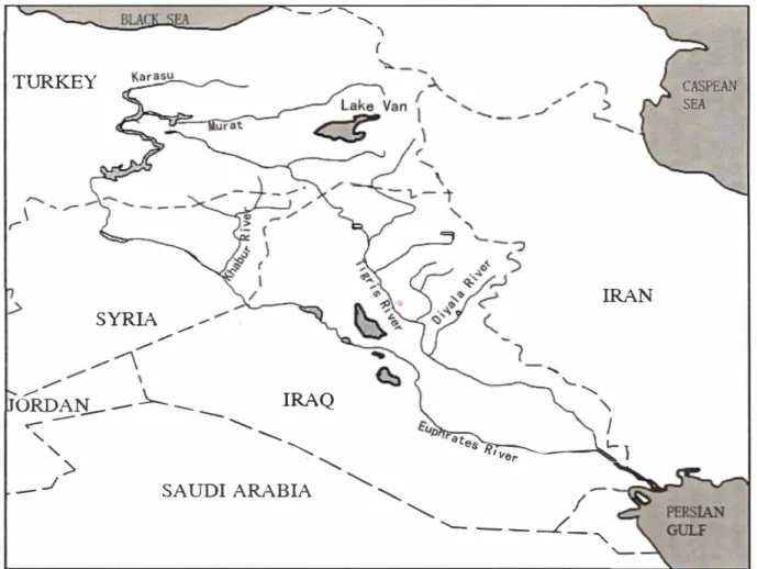
THE EUPHRATES-TIGRIS BASIN Geographical and Hydrological Characteristics
These characteristics alone give a rough initial sense of the high significance these two rivers possess, not only for the Turkish economy, but also for the larger basin economy. While the Euphrates River basin spans 444,000 km2, of which nearly one-third, one-fifth, and 46 percent lie in Turkey, Syria, and Iraq, respectively, the Tigris River Basin spans 387,000 km2, of which nearly 1 5 percent lies in Turkey and three-quarters in Iraq. Syria possesses a mere I ,OOO km2 of the basin area, a short leg of its boundary with Turkey (Kibaroglu et al. 2005, 55-57).
TURKEY
\-
,.-SYRIA ,.,,, .,,.
/ /....--- --'\
,.,,, .,,..,,.
.1.._ _ _
-
----IRAQ
"'
l (IRAN
1
...'-,
ORDA:r:L -...,_ -...,_--
',
"
'-
-...I
../
'>SAUDI ARABIA
'- '-.. '- - -
J_ "
-'
I
.ite� \ L- , - rr, "er � IFigure 2.2. The Euphrates-Tigris Basin
CASPEAN SEA
Both branches of the conjoined transbounc.lary walercourse system originate nearly 30 km from each other. At 2,700 km, the "longest river in south-west Asia west of the Ind us" (Kolars 1994, 51 ), the Euphrates flows for nearly half that distance in Turkey before crossing into Syria (OSI 2009a, 48). Its headwaters the Karasu and Murat rivers-form at 4,417 and 5,047 mas!, respectively, north of Erzurum and on Mount Ala north of Lake Van (Kolars and Mitchell 1991, 4). Some 45 km northwest of Elazig municipality, they join prior to reaching Keban Dam (see Table 2.3). Afterwards, the main channel receives numerous feeder streams and Malatya province's Tohma River tributary before reaching the Karakaya Dam in Diyarbakir; takes water from the Kahta River upstream from the Ataturk Dam and the Nizip River downstream from Birecik Dam; and finally passes southwest through a gorge near Hilvan before leaving Turkey at Karkamis, the site of the river's fifth main dam (Kibaroglu et al. 2005, 56).
In Syria, the river's left bank joins the Balikh and Khabour tributaries. After its confluence with the latter at Deir es-Zor, the Euphrates River receives no regular incremental flows of water (Kolars 1994, 51 ). Three hundred sixty km from the Syrian border, the river reaches its 100,000 km2 alluvial plain in Iraq and then drops only 53 m in altitude over the next 735 km to the Gulf, losing water to vari ous distributaries before reaching Nasiriya, where one part fissures into a skein of channels that drain into Lake Hammar and another part joins the Tigris River at Qurna, where the confluence flows into the 200 km long Shatt al-Arab estuary of the Persian Gulf (Kibaroglu et al. 2005, 56--57; Kolars 1994, 51).
Within Turkey, the Tigris starts close to the Euphrates headwaters, but quickly turns further east. At 1,840 km, "the second longest river in southwest Asia" (Kolars and Mitchell 1991, 6), this river rises in eastern Turkey near Lake Hazar, at 1,150 mas! and traverses Diyarbakir province before demarcating a 32 km section of the Turkish-Syrian boundary that starts at the Turkish city of Cizre (Kibaroglu et al. 2005, 57; Kolars and Mitchell 1991, 6). The river reaches its alluvial plain between Iraq's Tikrit and Samarra, but, in contrast to the Euphrates, receives its larger increment of water from tributaries that flow from the Zagros Mountains, partially from Iran: the Greater and Lesser Zabs (down stream from Mosul, Iraq) as well as the Adhaim and Diyala (Kolars 1994, 52). Estimates of mean annual runoff of these rivers vary. Natural flows, always highly variable across seasons and years, no longer exist in any calculable sense (Kibaroglu 2008, 184). Turkey's Ministry of Foreign Affairs (2010, 2-3) implies that Turkey provides just over 56 km3/year-3 I km3/year for the Euphrates and 25 km3/year for the Tigris-two thirds of the rivers' com bined annual flow. UNFAO (2010d) gives Turkey's collective contribution as 49.43 km3/year-28. I km3/year to the Euphrates (although natural flow of 26.29 km3/year is also cited) and 21.33 km3/year to the Tigris, 28.4 percent of Turkey's cited 173.8 km3/year of "actual" surface TRWR. Others (Kibaroglu
32 Chapter Two
2008, 1 84-1 85; Kibaroglu et al. 2005, 56-58) cite Turkey's contribution of 90 percent of the Euphrates's mean flow of 32 km3/year (28.92 km3/year) and 40 percent of the Tigris's mean flow of 52 km3/year (20.84 km3/year), a col lective share of 49.76 km3/year, comparable to UNFAO (20 1 0d) numbers.
One matter complicating resolution of Euphrates-Tigris disputes centers on the exact origins of the Balikh and Khabour tributaries of the Euphrates. As Kibaroglu et al. (2005, 56) state, "The Khabour sub-basin together with its transboundary tributaries and its springs is the most complicated element of the system; various branches of the Khabour originate either from Turkey or from Syria and are estimated to have a significant potential of 200 MCM/ year 10.2 km3/yearl." Leading experts claim that, since the catchment area of these springs lies in Turkey and can thus be impacted by groundwater pump ing there, Turkey may account for up to 98 percent of Euphrates flow (Kolars and Mitchell 1 991, 1 06-107; Kolars 1 994, 5 1 ).
Turkey's Use of Euphrates-Tigris Water
These waters are being harnessed to expand Turkey's agricultural and HEP output and to improve living standards in the southeastern region overlapping this basin. Some changes have taken place and GAP cities' drinking-water and wastewater treatment coverage rates reached 200 I national averages (Table 2.2). This region's laggard quality-per-capita GDP was 47 percent of the national mean in 1 985 (Nippon Koei Co. Ltd. and Yuksel Proje A.S. 1 990, I )-and pronounced ethnic divisions have fomented violent unrest. With the 1 989 GAP Master Plan, which converted an array of irrigation and HEPP projects (first named the "Southeast Anatolian Project" in 1 977) into an integrated "multi-sector social and economic development program for the region" (OSI 2009b:,36), development of this river basin in Turkey has come under the GAP Regional Development Administration (GAPRDA).
Development of Southeast Anatolia and increased exploitation of Euphra tes-Tigris water remain inextricably linked. State "planners are quick to note that the twin rivers represent over one quarter of Turkey's freshwater resources and a similar percentage of Turkey's hydroelectric potential" (Harris and Alatout 20 1 0, 1 48). GAP also accounts for one-fifth of national irrigable agriculture (Berkun 20 I 0, 649; Yuksel 20 I 0, 1473-1 474). GAP encompasses ten percent of the country's territory and population and host 1 3 projects (seven in the Euphrates basin and six in the Tigris basin) consisting of 22 dams and 1 9 HEPPs. These will have 7,490 MW of installed capacity and generate 27.387 TWh of HEP. 1.8 mha of cropland will also come under irrigation (OSI 2009a, 84-88; GAPRDA 2008, 5) (Table 2.3). GAP is also supposed to raise
Table 2.2. The GAP Region (2008) pop growth:
Province pop. 2007-08(%) urban(%) wsn*(%) dwt*(%) ss*(%) wwt*(%)
Adiyaman 585067 4 56 99 9 1 0 Batman 48561 6 27 72 98 92 Diyarbakir 1 492828 22 70 99 57 94 52 Gaziantep 1 61 2223 33 87 98 51 97 85 Kil is 1 20991 2 1 68 1 00 59 96 Mardin 750697 7 56 98 73 Sanliurfa 1 574224 33 56 99 50 93 1 2 Siirt 29981 9 28 60 98 97 Sirnak 429287 3 1 63 94 82 GAP 7350752 24 68 98 35 92 35 Turkey 71 5 1 7 1 00 1 3 75 99 50 88 56
* wsn, clwl, ss, ww = municipal popu lation with access l o water-supply network, drinki ng-water treatment, sewage system and wastewater treatment, respectively
Source: provinces/Turkey: Turkish Statistical Institute (Turkstal) 201 1 ; GAP: author computations based on Turkslal (201 1 )
Table 2.3. Euphrates-Tigris Basin Dams (Operating or under Construction in 2008) Construction Reservoir Installed Nominal Major DAM-and- (in order of Volume capacity Annual HEPP complexes completion) River/Province (km3) (MW) HEP (TWh)
Keban (non-GAP) 1 965-1 975 Euphrates/Elazig 3 1 .000 1 ,330 6.000 Karakaya 1 976-1 987 E uph rates/Di yarbaki r 9.580 1 ,800 7.354 Ataturk 1 983-1 992 Euphrates/San Ii urfa 48.700 2,400 8.900 Kralkizi 1 985-1 997 Tigris/Diyarbaki r 1 .91 9 94 0. 1 46 Dicle 1 986-1 997 Tigris/Diyarbakir 0.595 1 1 5 0.444 Batman 1 986-1 998 Tigris/Batman 1 . 1 75 1 98 0.483 Karkamis 1 996-1 999 Euphrates/Maras 0.1 5 7 1 89 0.652 Birecik 1 993-2000 Euphrates/San Ii urfa 1 .220 672 2.51 8
l l isu 2007- Tigris/Mardin 1 0.400 1 ,200 3.833
TOTAL 1 04.746 7,998 30.330
GAP (operational) 63.346 5,468 20.497
GAP Master Plan 7,490 2 7.387
Sources: all clams except Kralkizi and l l isu: DSI (2009a), 71; Kralkizi: DSI (201 l e); l l isu: Kibaroglu et al. (2005), 62-63; lola l/GAP (operational): author computations
3 4 Chapter Two
regional per-capita income over 200 percent and employ 3.8 million people (DSI 2009b, 38).
The project has faced recurring delays. Yuksel (2010, 1473) writes that, "Although current justifications for this mammoth project I GAPI mention irrigation and regional development as key objectives, the earlier plans were articulated squarely in terms of providing a secure electricity supply." Indeed, GAP's hydropower targets have come online more rapidly than its irriga tion components. "GAP's original schedule called for the irrigation of one million hectares of land with Euphrates waters, and 625,000 hectares with Tigris waters by the year 2002" (Kolars 1994, 67), a goal that proved overly ambitious. Even the master plan recommended completion by 2005 of only 894,000 ha (55 percent of planned irrigation) and 5,300 MW of installed capacity, 70 percent of the HEP target (GAPRDA 1990, I 0). By the end of 1996, only seven percent of irrigation targets and 56 percent of HEP targets had been reached (GAPRDA 1997, 64-65).
Financial shortfalls plagued this project. By 2000, only 44 percent of the project's US$32-billion cost had been met (GAPRDA 2000, 5). In 1 998, Turkey's Council of State mandated completion by 2010 (GAPRDA 2000, 6), but the later-admitted inadequacy of GAP's public-investment-bud get allocation-6.2 percent/year over 1999-2005-made this goal farfetched (DSI 2009a, 67; GAPRDA 2010, 5). In 2004, GAP's dam-and-HEPP instal lations, which supplied nearly 49 percent of Turkey's HEP and 15 percent of its electricity (Figure I ; GAPRDA 2010, 6), had met part of the master plan's 2005 "priority" goals. Excluding Keban Dam-and-HEPP, which came online prior to GAPRDA 's existence, the Euphrates hosts the Ataturk, Birecik, Karakaya, and Karkamis dams and two stand-alone HEPPs (Sanliurfa and Cagcag), while the Tigris hosts Batman, Dicle, and Kralkizi and is awaiting completion of Ilisu Dam by 2014 (DSI 2009a, 70). Thus, three-quarters of GAP's HEP potential has been realized (DSI 2010, 66).
Conversely, GAP's irrigation progress lags behind. By the end of 2005, only 245,613 ha-roughly 13.5 percent of total GAP land-were being irri gated (GAPRDA 2010, 7). In 2008, the GAP Action Plan prioritized nearly 1.06 mha, roughly 59 percent of the original target, for completion in 2012 (DSI 2009a, 85). By 2010, after two consecutive years of enhanced GAP shares of the public-investment budget ( 12.1 percent in 2008 and 14.4 percent in 2009), 300,397 ha of GAP land, 16.5 percent of the total target (GAPRDA 2010, 5, 7) or 28 percent of the Action Plan's priority target (DSI 2010, 66), had been brought under irrigation. In fact, the uncompleted fraction of GAP's irrigable land makes up nearly 47 percent of the 3.22 mha of Turkey's total irrigable area that is not yet being irrigated. The Euphrates area has come out ahead here. By 2010, according to DSI (2010, 67), while the 256,898 ha
bei ng i rrigated in the Euphrates Basin represented 22 percent of that basi n ' s G A P i rri gation target and 8 6 percent of al l GA P i rrigation, the 43 ,499 ha bei ng i rrigated in the Ti gri s Basi n accounted for seven percent of that basi n ' s i rrigation target and 1 4 percent o f al l G A P i rri gation.
TURKEY IN THE DOWNSTREAM POSITION The Maritsa Basin
Bulgaria generates the headwaters of three transboundary tri butaries of this ri ver system. Upon leav ing Bul garian territory, the 500 km central Mari tsa stream forms a short 1 5 km boundary between Bul garia and Greece and then a 1 87 km boundary between Greece and Turkey, then it enters the Aegean Sea. On its way south to the sea, however, its right bank picks up water from the A rda tri butary, which travels its fi rst 240 km through Bulgaria and its fi nal 30 km through Greece, while its left bank takes i n the Tundja Ri ver, which also ori gi nates in Bulgaria before demarcati ng a 1 5 km stretch of the Turkish-Bul garian boundary and fi nal ly flowing another 30 km through Tur key, which adds its own Ergene tri butary to the Mari tsa nearly 30 km from the estuary (Ki barogl u et al . 2005 , 26-28).
The u pstream state in this ri ver bas i n also happens to hold the bul k of both the bas i n area and i ts annual runoff. B u l gari a sits on nearl y two thirds of the 50,000 km2 drai nage area, w h i l e 26 percent l ies in Turkey and
ei ght percent in Greece, which, however, has four-fi fths of the Mari tsa' s 1 88 ,000 km2 al l uv i al del ta zone, winter home t o 300 species o f bi rds and
enjoying protected wetland status under the Ramsar Convention. S i m i l arl y, B u l gari an tri butaries supply 7 1 percent o f the basi n ' s average annual runoff of 8 km3 , while Turkey prov ides 23 percent and G reece suppl ies six percent (Ki barogl u et al . , 28, 36).
Turkey's portion of the basin area is geographical ly located i n Europe and represents one of the most developed parts of the country. Accord ing to Turkstat (20 1 1 ) data, the Edi rne and Ki rklarel i provi nces are 66 and 65 percent urban and thei r municipal populations had an average per-capi ta water supply of 1 54 1/d and 257 1/d, respecti vely, i n 2008. Even though this region is highly i ndustrial ized and i ndustrial runoff generates much waterborne pol l ution, Turkey's Ergene basin al so contai ns producti ve agri culture. Of the 1 .24 mha esti mated to be arable, approximately 26 percent is i rri gable, but only 44 percent of i rri gable land was bei ng i rri gated as of 2003 (Ki barogl u et al . 2005 , 29). Seven dams have been supplying water to 60,000 ha, about two-fifths of Turkey's total Maritsa i rri gation (OSI 20 1 1 f, 20 1 1 g). If al l planned projects come to fruition, 257,000 ha may come under
36 Chapter Two
irrigation, drawing on 2.15 km3 of water (Kibaroglu et al. 2005, 29). Presently under construction on the Turkish-Bulgarian section of the Tundja tributary is the Tundja Dam, which should provide irrigation water for nearly 16,000 ha and flood control for 2,500 ha and have 11.68 MW installed capacity, capable of generating 37 GWh/year of HEP (DSI 201 I f).
The Orontes Basin
The main stem of this river crosses Lebanon (upstream), Syria (midstream), and Turkey (downstream). Originating in the Bekaa Valley and flowing north between the Lebanon and Anti-Lebanon mountain ranges for 35 km before reaching Syria, it flows for another 325 km in Syria until it crosses the Turkish border, after which it traverses its final 88 km through Turkey's Hatay prov ince, taking the confluence formed by the Karasu and Afrin tributaries (which originate in Turkey but border and traverse Syria, respectively, before re-enter ing Turkey) before meeting the Mediterranean Sea (Kibaroglu et al. 2005, 66). Nearly half of the 37 ,OOO km2 catchment area lies in Turkey, another 44 percent in Syria, and the remaining six percent in Lebanon, the uppermost riparian state, which generates only 11 percent of the estimated 2.8 km3 discharge, while Syria supplies 43 percent and Turkey 46 percent (Kibaroglu et al., 66-67). Hatay faces tight constraints on the extent to which it can develop all of its planned water uses. Less than half urbanized, municipal residents of the province had access to 183 lid of water on average in 2008 (Turkstat 2011 ). At present, approximately 22,000 ha are being irrigated in the basin (DSI 2011 h). If further plans materialize, it may be possible to bring up to 100,000 ha under irrigation, generate 180 GWh/year of HEP, supply 37 hm3 of drinking water and provide flood control for 20,000 ha (Kibaroglu et al. 2005, 69).
Disputes and Resolution Efforts between Turkey and its Riparian Neighbors
A central point to be underscored here concerns the nature of the relationship between Turkey's water-related disputes and its other conflicts with neigh bor ing states in the transboundary river basins in question. While Turkey's water related disputes have the distant potential to escalate into overt armed conflict (Klare 2001, 173-182), evidence is just as scant to support the possibility that Turkey can achieve "water peace" (Conca and Dabelko 1997), wherein functionalist or even "epistemic community"-driven (Kibaroglu 2008) basin centric cooperation may impel a more broadly cooperative relationship between Turkey and its neighbors. In short, while exchanges of informa tion and viewpoints occur among basin-state technical officials (Beschorner
1992/1993, 42), the quality of riverine cooperation is more likely to track the status of overall relations than vice versa (Brunee and Toope 1997, 47). The Maritsa Basin
The main axis of historical disputes in this basin involves Bulgaria and Turkey. With the industrialization of Bulgaria during the Cold War its needs for water increased. In the Bulgarian part of the basin, there exist 21 dams capable of holding about 3 km3 of water (over half of the total basin runoff that Bulgarian territory contributes), 2.5 million people, and fertile agricul tural land in the area of Plovdiv. The region has reportedly experienced water stress and quality deterioration (Kibaroglu et al. 2005, 29). Bulgaria has his torically served as a font of negative externalities: In addition to a consider able volume of agricultural, livestock, and heavy-metal effluents generated there, its dams have aggravated scarcity and flooding as well as sedimenta tion in Greece and Turkey. As recently as 2005, inundation damaged large swaths of property in Greece and in the Edirne vicinity of Turkey (Kibaroglu et al. 2005, 30-31). Turkey's officials frequently underscore the importance of controlling floods, which inflict US$ J OO million/year of damage to its ter ritory (OSI 2009b, 28).
Even before the end of the Cold War these two parties have agreed on certain issues. In 1968, both countries signed an agreement committing themselves to "good neighborly" limits on mutual harm, data exchange on flooding, and dispute settlement by joint commission. In 1975, they signed another technical accord on the use of boundary waters for HEP and irriga tion (Kibaroglu et al. 2005, 33). The end of the Cold War provided a fresh impetus to cooperation, not least because of the sudden decline in post-Soviet economies. During the 1990s, Bulgarian water use and industrial waterborne pollution decreased considerably (Kibaroglu et al. 2005, 30). This created an opening for further Turkish-Bulgarian cooperation in 1993, when Turkey agreed to purchase nearly 16 hm3 of irrigation water from Bulgaria during a drought period. In 1998, both countries decided on a later-aborted project to build three joint dam-and-HEPPs on the Arda tributary and Turkey assented to buy the HEP (Kibaroglu et al. 2005, 33). As part of a larger 18-dam "Border Dams Project" (Yavuz 2011 ), construction started in 2009 on the aforemen tioned joint Tundja Dam project (OSI 201 I f), originally conceived as part of the two countries' 1968 accord, but not revived until 2002 (Kibaroglu et al. 2005, 34). The two countries are also using EU funds to implement a flood forecasting system on their border (OSI 2009b, 29).
Turkish-Greek agreements on the Maritsa predate those between Turkey and Bulgaria. In 1 934, Turkey and Greece signed an agreement specifying
38 Chapter Two
permitted flood- and erosion-control infrastructure and providing for data exchange, priornotification, and dispute settlement, and then in 1955, signed an unpublished agreement on construction of flood-control measures (Kibaroglu et al. 2005, 31-32). However, it was not until after substantial improvement in bilateral relations in 1999 that Greco-Turkish basin cooperation acquired fresh momentum. Under the environmental component of the European Commission's (EU) Community Initiative Program INTERREG III A/ Greece-Turkey, "priority will be given to the integrated management of the cross-border waters in accordance with the Water Framework Directive and to the management of ecosystems of exceptional ecological significance" (Kibaroglu et al. 2005, 32). The 2000 European Water Framework Directive contains explicit measures oriented towards shared management among member states, coordination between member states and non-member states, and environmental conservation and protection (UNDP 2006, 221 ). As Bulgaria and Greece, which signed the UNECE Water Convention and have their own joint agreements dating back to 1964 and 1971, had already been cooperating after the Cold War within the framework of the latter INTERREG program (Kibaroglu et al. 2005, 34), even before the latter joined the EU in 2007, this program and the Directive could serve to bring about tripartite arrangements to address unresolved issues of water allocation and quality as well as minimum freshwater inflows into the delta region.
The Kura-Araks Basin
In this basin, Turkey has not been generating the heaviest downstream impacts. For example, while Turkey plans to develop its section of the Kura River, the most significant pollution on that tributary originates from "Georgian industrial sites and urban conglomerations" (Kibaroglu et al. 2005, 43), which affect Azerbaijan. Furthest downstream, Azerbaijan has received industrial pollutants and agricultural pesticides emanating from Armenia and Georgia (Kibaroglu et al. 2005, 41 ). Turkey could have a larger impact upon the Araks River, but little of this will emanate from industrial activity. While several Turkish provinces in the area show "comparatively good environmental conditions," watershed degradation, erosion, and agricultural runoff remain key problems (Kibaroglu et al. 2005).
Turkey has numerous agreements with Georgia, Armenia, and Iran dating back to Soviet times. In fact, today's basin-centric relations between Turkey and Georgia (on both the Kura and Coruh) as well as between Turkey and Armenia (on the Arpacay tributary of the Araks) rest largely on the 1927 Kars Protocol between Turkey and the Soviet Union. This agreement encompasses border delimitation, riverbank protection, equal water shares (unlike the
Maritsa and Orantes basi ns, where allocations do not exist), compensation provisions, and a joint water-boundary commission (Kibaroglu et al. 2005, 39, 45). In 1 964, Turkey agreed with then-Soviet republic Armenia to build the aforementioned Arpacay Dam, constructed between 1 975 and 1 983 (OSI 20 1 1 i). Moreover, the scope of this accord covered equal allocation of the dam's water and creation of a joint operating commission (Kibaroglu et al. 2005, 39, 45). The last agreement on this issue between Turkey and the Soviet Union in 1 990 mandated that efforts to prevent or facilitate riverbed adjust ments be jointly consensual (Kibaroglu et al. 2005, 45). In 1 955, Turkey also agreed to supply Iran at least 1 .8 m3/s of water from the Sarisu tributary and
divide Karasu tributary water i n half (Kibaroglu et al. 2005).
After the Cold War, these Soviet-era agreements remained i n force. None theless, cooperation among the downstream riparians, particularly the Former Soviet Union (FSU) countries of Armenia, Azerbaijan, and Georgia, has not advanced much, as the "intra-Soviet Union mechanism of cooperation, i nfor mation sharing . . . ceased to function after the break-up of the Soviet Union," and integration of uppermost riparian Turkey began much later (Kibaroglu et al. 2005, 44). In the early 1 990s, Armenia and Azerbaijan fought over the disputed Nagorno-Karabakh enclave, resulting in the flight of about one mil lion ethnic Azeris to Azerbaijan. Supporting Azerbaijan's blockade of this enclave, Turkey severed official relations and closed its border with Armenia and has not yet normalized them despite efforts in this direction since late 2008. Although Turkey has faced international condemnation for its alleged genocide against Armcnians i n 1 9 1 5, domestic politics and Azerbaijan's threats to withhold natural gas supplies that Turkey needs to fuel its economy and bolster its role as an East-West energy corridor continue to hinder Turk ish-Armenian rapprochement (Tekin and Williams 20 1 1 , 1 60- 1 6 1 ). Turkey's ability to gain Armenia's assent to adjusting the Araks riverbed to facilitate Turkey's ability to use the Arpacay Dam for irrigation has been correspond ingly undermi ned (Kibaroglu et al. 2005, 43-44).
Turkey enjoys better post-Cold War relations with Georgia. This stems partly from Georgia's disinterest in Turkey's plans on the Kura and Araks branches: Georgia, the main source of negative externalities on the Kura, "lacks the basic monitori ng capabilities required to . . . assess the water quality of the Kura River and to quantify the pollutants stemming from the Turkish stretch of the river" (Kibaroglu et al. 2005, 46). It also relates to Turkish-Georgian cooperation over pipelines that transport some of Azerbaijan's hydrocarbon supplies via the parallel Baku-Tbilisi-Ceyhan (BTC) oil and South Caucasus gas pipelines, which traverse Georgia on their way to Turkey. Between late 1 998 and late 1 999, Azerbaijan, Georgia and Turkey signed both the Ankara Declaration expressing support for the BTC
40 Chapter Two
and an intergovernmental agreement on this project at the Organization of Cooperation and Security in Europe (OSCE) summit in Istanbul (Baran 2005, I 06-1 07). In 2000, Turkey and Georgia agreed on further technical coopera tion and on certain riverbed changes (Kibaroglu et al. 2005, 39), and, in late 20 1 0, decided to build a joint dam on the Kura (Yavuz 20 1 1 ).
Economic ties work analogously in the Turkish-Iranian relationship. Despite UN and U.S. sanctions on Iran, Turkey imports about 5 km3/year of natural gas from Iran through a pipeline that can deliver twice as much, to the same Erzurum hub that receives Azerbaijan gas (Tekin and Williams 201 1 , 1 48, 1 50, 1 58-1 59). Just as Iranian gas deliveries have not always been reliable in winter (Tekin and Williams 2009, 347), Sarisu water to Iran often falls short of Turkey's pledged 1 .8 m3/second during dry seasons (Ki barogl u et al. 2005, 46). Still, both countries have agreed to build an Araks dam to generate 1 92 GW/year of HEP (Yavuz 20 1 1 ).
The Coruh Basin
As in the Kura Basin, the aforementioned 1 927 Kars Protocol also applies to the Coruh Basin, although its practical value has diminished in light of new environmental issues. As opposed to the Kura-Araks, however, development and pollution in the Coruh Basin, which receives urban wastewater and mining discharges, do not have major agricultural characteristics, either in Turkey (because of the topographical conditions that make it more highly conducive to HEP exploitation) or in Georgia, where fishing in this basin holds more importance than water consumption (Kibaroglu et al. 2005, 50, 5 1 ). By contrast, one of today's key problems, acknowledged by both parties yet largely unmeasured, consists of the anticipated dramatic alteration of the river's sedimentation patterns caused by Turkey's dams and the consequent effects on Georgia's alluvial delta and Batumi-area coastline, which are shielded from the Black Sea's eroding force by the river's sediment deposits (Berkun 20 1 0, 655).
As mentioned above, two Master Plan dams, the Muratli and Borcka dams, are already operating. They generate up to 1 .3-1 .4 TWh of HEP per annum and store up to 1 0 km3 of water (OSI 2009a, 71 ), exceeding the average annual flow. "Georgia is not dependent on the Coruh for either energy or water; this clearly reduces the potential for conflicts" (Kibaroglu et al. 2005, 50). Less auspiciously, however, Turkey's Deriner and Yusufeli projects, which are not yet online but will generate about 3.8 TWh/year of HEP (OSI 20 1 0, 52), could have worse environmental impacts. While the Deriner Dam and-HEPP, just upstream of the Borcka, threatens sedimentation blockage, the Yusufeli complex may have adverse effects on plants, mammals
(including wild goats and bats), fish (especially migratory salmon), and over 1,400 ha of the 23,000 ha Coruh Valley Wildlife Protection Area (Berkun 20 I 0, 655-656).
The broader Turkish-Georgian ties enumerated above aid cooperation on Coruh basin issues. FSU state Georgia acceded to the various Turkish-Soviet accords regulating their boundary waters, which encompass the Coruh 's three-km border segment (Kibaroglu et al. 2005, 51 ). Both countries belong to the 1992 Bucharest Convention, which mandates controls on land-borne pollution and the dumping of waste into the Black Sea as well as joint response to accidents, and to the Black Sea Environmental Program (Berkun 2010, 652-653)-two Istanbul-based organizations that could facilitate coop eration on the Coruh due to its interface with the Black Sea (Kibaroglu et al. 2005, 52). Further bilateral technical cooperation and consultations occurred in the 1990s, with Turkey seeking to widen the scope of cooperation to enhance mutual gains in contrast to Georgia's narrower focus on compensa tion for coastal erosion. Turkey, concerned with data inadequacy, assumed responsibility for financing two disused flow-monitoring stations in Georgia, and assented to set up a joint group to monitor the effects of Deriner Dam, which broke ground in 1998 (Kibaroglu et al. 2005, 53). With more Coruh dams coming online without a comprehensive accord in place, Georgia has continued to seek compensation, and, though Turkey produced an environ mental impact report on Yusufeli, scientific assessment has not been jointly consensual (Kibaroglu et al. 2005, 53).
The Euphrates-Tigris Basin
Even though previous bilateral accords existed between Turkey and Syria during French colonial administration, and between Turkey and Iraq on flood control measures, prospective expansion in water uses led to more intractable disputes starting in the 1960s. Between 1965 and 1975, Turkey built the Keban Dam. During this time, while Syria had launched the Euphrates Valley Project, with an irrigation target of 640,000 ha, Iraq was already operating the Euphrates Dam to divert water into AI-Habbaniya Lake (Kibaroglu 2008, 186) and withdrawing 45 percent of mean annual Euphrates flow (Naff and Matson 1984, 90). Even now, Turkey depends on external sources for only one percent of its TRWR and withdraws less than one-fifth of the latter, while Iraq, which withdraws 87 percent of its TRWR, has a 53 percent "dependency ratio," and Syria, which withdraws nearly all of its TRWR, has a 72 percent "dependency ratio" (UNFAO 2010a; 2010b; 2010c).
Thus, downstream states have been cool to Turkish projects. In the first of two bilateral meetings in 1964, Turkish officials pledged to Iraq to maintain a
42 Chapter Two
minimum flow of 350 m3/s downstream from Keban and advanced its current position that the two rivers, which join in Iraq, belong to a common water course, implying that Iraq could compensate for Euphrates shortages from the Tigris. The second meeting between Turkey and Syria aired similar issues (Bilen 1997, 111-112). By 1965, the World Bank approved transboundary basin project loans. Ankara secured World Bank and USAID funding for Keban only by sticking to its previous 350 rn3/s pledge (Kut 1993, 4). It also obtained European Investment Bank (EIB) and other European monies for this US$85-rnillion project (Kolars 1994, 62). Turkey also offered to convene a Joint Technical Committee (JTC) to identify each state's water and irriga tion needs, but Iraq pressed for guaranteed flows and shares (Kibaroglu 2008, 186). The construction of Turkey's Keban and Syria's Tabqa darns by the rnid-l 970s worsened the effects of drought and led each downstream state to fault its immediate upstream neighbor; Baath Party leadership rivalry pushed Iraq to the brink of war with Syria (Naff and Matson 1984, 93-95).
By 1980, Syria and Iraq had drawn closer on Euphrates-Tigris water issues. Between 1976 and 1987, Turkey built the Karakaya Darn, which also regulates Keban outflows (Bilen 1997, 113). In 1979-1980, Turkey pledged in writing to guarantee at least 500 rn3/s of Euphrates flow (Kut 1993, 5) to obtain World Bank funds; additional EIB, Swiss, Italian money, and outside loans met half of the project's US$1.16-billion cost (Bilen 1997, 115). In 1980, Turkey and Iraq formed the JTC. While Syria did not participate in the JTC first meeting in 1982, by 1983 Syria, which had once concurred with Turkey that the two rivers formed a single watercourse, was favoring the Iraqi stance that the rivers should be addressed singly (Bilen 1997, 112). In 1984, at the JTC's fifth meeting, Turkey advanced its "Three-Staged Plan for Optimal, Equitable and Reasonable Utilization of the Transboundary Watercourses of the Euphrates-Tigris Basin." This scheme was to inventory all basin water and land resources, identify actual needs, and jointly compile data, but Iraq and Syria insisted on divisions (Bilen 1997, 117-118; Kibaroglu et al. 2005, 61 ). The JTC met 16 times, but failed by 1993 for lack of a "clear and jointly agreed mandate" (Kibaroglu 2008, 187). By 1990, in proximity to the Ataturk Darn, Syria and Iraq had agreed to a respective 42-58 split of Euphrates flow at the Turkish-Syrian boundary and were demanding a minimum of 700 rn3/s there (Williams 2001, 30).
Tensions escalated when Turkey built its mammoth Ataturk Darn. This dam can supply 328 rn3/s to the Sanliurfa Tunnels for irrigation of 476,000 ha (GAPRDA 1997, 15). With this project, Turkey lost its World Bank funding for GAP. It however obtained US$571 million in foreign loans which made up a small fraction of the dam's US$ ! I -billion cost (Kolars 1994, 62). Though the Karkarnis and Birecik darns are only equipped for HEP and re-regulation
of Ataturk Dam outflows (Ministry of Foreign Affairs 2004, 6--7), the Atat urk Dam controversy made foreign monies even scarcer. This necessitated Turkey's heavier reliance on "Build, Operate and Transfer" (BOT) schemes (where private firms build and operate projects until they secure a reasonable return, at which point they revert to host-government control), as with Birecik Dam (Williams 2001, 30), or on domestic funds.
By the new millennium, six major dams were already operating on Turkey's section of the Euphrates. This feat occurred against considerable resistance, not just from downstream states, but from an array of various domestic and international NGOs-Ataturk, Karakaya and Keban dams were estimated to have displaced about 145,000 people (McCully 2001, 334). Opposition of a similar nature confronted Tigris projects. In 2001, the Ilisu Dam remained blocked by NGO concerns that the dam would flood 52 villages and 15 small towns including Turkey's cultural-heritage city of Hasankeyf and displace up to 20,000 inhabitants, as well as by Iraqi worries over this dam's effects on its marshland delta (Berkun 2010, 651; Kibaroglu et al. 2005, 64-65). By 2006, however, Turkey obtained a US$1.64 billion loan package backed by European export-credit agencies, allowing construction to start in 2007 (Berkun 2010, 650). Coming on the heels of Iraqi claims that Iraq's spring water reserves had plummeted from 40 km3 to 11 km3 due to Turkish dams (Jongerden 20 I 0, 138), the 2009 withdrawal of official Austrian, German, and Swiss loan guarantees left Andritz AG as the sole foreign consortium member. Turkey's Prime Minister Recep Tayyip Erdogan of Turkey casti gated environmentalists as "terrorists" (Steinvorth 20 I 0).
Syrian and Iraq opposition was not confined to verbal demarches. Their territories also served as bases for the Kurdistan Workers Party (PKK) to carry out its insurgency in Turkey. Lebanon's then Syria-controlled Bekaa Valley provided an initial launching pad for PKK incursions into Turkey's southeast after 1984, one year after the Ataturk Dam broke ground. In 1998 Turkey's troop buildup forced then Syrian leader Hafez al-Assad to expel PKK head Abdullah "Apo" Ocalan, who was captured in Kenya and brought back to Turkey in 1999. During this period, Turkey both appeased and threat ened Syria. Turkey's 1987 protocol underlined its commitment to allowing at least half of the Euphrates flow (500 m3/s) to cross into Syria, but Turkish leaders occasionally threatened to cut Syria off (Williams 200 I , 29-31 ). As the Ataturk Dam's reservoir took nearly eight months in 1990 to fill and its HEP turbines required another 1.5 years (July 1992-December 1993) to come fully online (GAPRDA 1997, 13), this dam infused threats of water blockage with greater potency.
Turkish officials have unfailingly depicted their hydrological projects and operations in law-abiding terms. They contend that: the Ataturk Dam's filling
44 Chapter Two
violated neither legal obl igations to give prior notification nor thei r country's 1 987 protocol commitment to Syria; Turkey's mountainous southeast is more opti mal for basin projects than further downstream, where flatter topogra phies, higher evaporation rates, and soil gypsum are poorly suited to HEP and irrigation; and their dams have evened out flow variations, thus providing a pub! ic good rather than worsen water shortages (Bilen 1 997, 68-73 ). Accord ing to the Ministry of Foreign Affai rs (2004, 6), extra releases of water from the Keban and Karakaya dams counteracted both the effect of the 1 988- 1 989 drought which lowered Euphrates flow to 50 m3/s and maintained flow between November 1 3, 1 989 and February 1 3, 1 990-coveri ng the .January
1 990 filling of the Ataturk Dam -at an average of 509 m3/s.
Whi le Turkey's position emerged out of this earlier period of Turkish Syrian hosti lities - largely centered on the water-PKK nexus- PKK terrorism now sours Turkish-Iraqi relations. The 2003 US-led invasion of Iraq, which consol idated the partial autonomy of northern Iraq's "Kurdistan Regional Government" (KRG), revived PKK incursions into Turkey. It is difficult to ascertai n the extent to which the completion of GAP, especially its irrigation targets, which may have stimulated PKK action independent of Syria's sup port, was slowed by terrorism-related instability in Turkey's southeast or sim ply by the glacial pace of land redistribution and on-farm training identified by Kolars ( 1 994, 67-68). As part of the aforementioned "Border Dams Project," Turkey has been building a moat-like string of 1 4-originally 3 3 - new dams in its Si rnak and Hakkari provinces to deter PKK incursions from Iraq and to generate HEP (Haber 7 Com 20 I O; .Jongerden 20 I 0, 1 42; Yavuz 20 1 1 ).
Turkey's relations with its riparian neighbors in this basin have vastly improved since the 1 980s and 1 990s, but it is unclear how this has impacted river-centric cooperation. While Turkish governments present legal istic stances even on the use of transboundary waters where Turkey is upstream, they also reject the notion of formal international water law. Turkey is one of three slates, incl udi ng B urundi and China, to vote against the 1 997 UN Convention on the Non-Navigable Uses of International Watercourses. Turkey does not oppose the convention in its entirety, accepti ng the basic sti pulations contained in articles 5-9 (Ministry of Foreign Affairs 2004, 8-9). Yet, Turkey o�jected to what its officials perceived as the convention 's excessive enumeration of prior-notification obligations while neglecti ng to spel l out "sovereignty of states over the parts of transboundary watercourses located in thei r territory" (OSI 2009b, 50). While Turkish governments do not advocate the obsolete principle of "absol ute territorial sovereignty," former Pri me Minister Suleyman Demi rel exempl ified the official Turkish view that " 'water is an upstream resource and downstream users cannot tell us how to use our resources"' (Bagis 1 997, 577).