THE ADMINISTRATIVE, ECONOMIC AND SOCIAL RELATIONS OF SOFIA IN THE 18TH CENTURY: AN ESSAY OF THE SPATIAL
ANALYSIS A Master’s Thesis by AYLİN KAHRAMAN Department of History
İhsan Doğramacı Bilkent University Ankara July 2018 A Y LİN K A H R A MAN TH E A D M IN IS TR A TI V E, EC O N O M IC A N D S O C IA L B ilke nt U ni ve rsi ty 20 18 R ELA TI O N S O F S O F IA I N TH E 1 8 TH C EN TU R Y
2
THE ADMINISTRATIVE, ECONOMIC AND
SOCIAL RELATIONS OF SOFIA IN THE 18
THCENTURY:
AN ESSAY OF THE SPATIAL ANALYSIS
The Graduate School of Economics and Social Sciences
of İhsan Doğramacı Bilkent University
by
AYLİN KAHRAMAN
In Partial Fulfillment of the Requirements for the Degree of MASTER OF ARTS
THE DEPARTMENT OF
HISTORY İHSAN DOĞRAMACI BİLKENT UNIVERSITY
ANKARA
I certify that I have read this thesis and have found that it is fully adequate, in scope and in quality as a thesis for the degree of Master of History.
I certify that I have read this thesis and have found that it is fully adequate, in scope and in quality as a thesis for the degree of Master of History.
I certify that I have read this thesis and have found that it is fully adequate, in scope and in quality as a thesis for the degree of Master of History.
Approval of the Graduate School of Economics and Social Sciences
iii
ABSTRACT
THE ADMINISTRATIVE, ECONOMIC AND
SOCIAL RELATIONS OF SOFIA
IN THE 18
THCENTURY:
AN ESSAY OF THE SPATIAL ANALYSIS
Kahraman, Aylin M.A., Department of History Supervisor: Prof. Dr. Özer Ergenç
July 2018
In this thesis, Sofia which was the pasha sandjaghi of the Rumelian Eyalet in the 18th century is discussed. The administrative, social and economic relations of Sofia are studied within the context of spatial analysis. The interaction of Sofia with its surrounding rural area and other sandjaks are evaluated with regard to distance in order to analyze these relations properly and the surrounding rural area of Sofia is also addressed as a feeding ground. Since the data about population would enlighten our analysis, population forecasts are made through the available avarız hane defteri. The theoretical frame of our topic is constituted being taken the settlement models that belonged to the pre- industrial period as a basis. In addition, the court records of Sofia dating the first half of the 18th century are used with the aim of supporting our argument empirically. While the research conducted until this time only discussed the administrative and social structure of Sofia in the 16th century, in this thesis the
iv
question how Sofia maintained its importance as an administrative unit through centuries is tried to be answered and the relation of Sofia with its surrounding rural area is evaluated as an economic integration field.
Keywords: pasha sandjaghi, Sofia, the Rumelian Eyalet, the 18th century, the surrounding rural area.
v
ÖZET
18. YÜZYILDA SOFYA’NIN İDARİ, İKTİSADİ VE
SOSYAL İLİŞKİLERİ: BİR MEKÂN ANALİZİ DENEMESİ
Kahraman, Aylin Master, Tarih Bölümü
Tez Yöneticisi: Prof. Dr. Özer Ergenç
Temmuz 2018
Bu tezde 18. yüzyılda Osmanlı’nın Rumeli Eyaleti’ndeki paşa sancağı olan Sofya ele alınmaktadır. O dönemde Sofya’nın idari, sosyal ve ekonomik ilişkileri bir mekânsal analiz bağlamında incelenmiştir. Bu ilişkileri doğru bir şekilde analiz edebilmek için Sofya’nın etrafındaki kırsal çevre ve diğer sancaklarla etkileşimi mesafe açısından değerlendirilmiş, ayrıca kırsal çevre Sofya’nın beslenme alanı olarak ele alınmıştır. Nüfus verileri yapacağımız analize ışık tutacağı için elimizdeki avarız hane defteri aracılığıyla nüfus tahminleri yapılmıştır. Konunun teorik çerçevesi sanayi öncesi döneme ait yerleşme modelleri esas alınarak oluşturulmuştur. Ayrıca Sofya
mahkemesince düzenlenen kadı sicili de argümanımızı ampirik olarak desteklemek amacıyla kullanılmıştır. Bu zamana kadar yapılan çalışmalar genel olarak 16. yüzyılda Sofya’nın idari ve sosyal yapısını ele alırken, bu tezde 18. yüzyılda Sofya’nın hem idari bir birim olarak önemini yüzyıllar boyunca nasıl koruduğu
vi
sorusu cevaplanmaya çalışılmış, hem de çevresindeki kırsal alanla ilişkisi bir ekonomik entegrasyon alanı olarak değerlendirilmiştir.
vii
ACKNOWLEDGMENT
This thesis is the first writing experience for me and with this study I aim to carry the previous research done one step further and make a new interpretation from a
different point of view. While I am writing this thesis, my dear husband Okan provided full support for me and shared my excitement. Therefore, I would like to express my deepest gratitude to my husband. I am also thankful to my instructor Nil Tekgül for her support by encouraging me and for her valuable comments. My friend Derya also supported me with her remarks while editing my English. I would like to express my warmest thanks to my dear mother and father who were always there whenever I needed them helping me to relieve my anxieties. I cannot think of a life without them. My appreciation to all my professors in the Department of History since they contribute a lot in shaping my understanding of history. However, my advisor Prof. Dr. Özer Ergenç deserves the most. I offer my sincerest gratitude to him, who has not refrained to support. His immense knowledge about Ottoman history always enlightened my way. He did not only contributed scientifically, but also shared my anxieties with his patience. I will always be proud of being one of his students and I will always feel myself lucky. This journey is a beginning for me and there are a lot of things that I will learn from him.
viii
TABLE OF CONTENTS
ABSTRACT………iii ÖZET………v ACKNOWLEDGMENTS………..vii TABLE OF CONTENTS………..viii LIST OF TABLES………...ix CHAPTER I : INTRODUCTION……….11.1 Objective of the Thesis……….…...1
1.2 Literature Review ………....4
1.3 Sources and Methodology………8
CHAPTER II: THE EYALET OF RUMELIA AND SOFIA……….14
2.1The Spatial Analysis of the Eyalet of Rumelia………...…………24
CHAPTER III: THE POPULATION OF SOFIA AND ITS NUTRITIONAL CAPABILITIES………...41
3.1The Population of Sofia………..44
3.2The Nutritional Capabilities of Sofia………..59
CHAPTER IV: CONCLUSION……….67
ix
LIST OF TABLES
Table 1. The Distances between Sofia and Other Sandjaks………...32 Table 2. The Distance Between Sandjak of Sofia and Its Districts
and Sub- districts………...33
Table 3. The Number of Avarız-hanes in the Villages of Kada of Sofia………..48
1
CHAPTER I
INTRODUCTION
1.1 Objective of the Thesis
This study is an essay of spatial analysis in the Sofia example. In this thesis we will address the spatial situation of Sofia which was one of the important cities of Ottoman Rumelia in the eighteenth century with respect to the settlement theories and use of the data drawn upon primary sources. The reason why we address the 18th century in our study is that the 18th century symbolizes the transformation period in which both the practices of classical age and new practices were carried out in the simultaneously. Furthermore, the 18th century was a preparatory period that would carry the Ottoman State to the 19th century due to some important developments.
Because of the fact that manufacturing and transportation had been based on man and animal power before the Industrial Revolution, the relations of settlements with each other were determined by the technology level of that period. According to the settlement theories, the surrounding rural area determined the size of the settlement area which was called as “city” or “town” and diversity of functions undertaken at that period. Furthermore, whether any city or town is on the transit route or not, whether the geographical location paves the way for the natural protection,
climatological conditions and the productivity level of surrounding rural area were important factors. In the pre- industrial period, the main foundations of a society
2
were mainly determined by the models of spatial organization.1 These models vary as a settlement around the transportation system, isolated city model, the model based on the relation between the hierarchy of the spatial organization and land tenure and center- front model. In all these models, production and transportation technology determined the form of spatial organization. In the pre- industrial societies, the main factor determining the social organization was the amount of surplus produced by the agricultural production technology. The mechanism that enabled the control groups to collect the surplus product was the taxation system. In the Ottoman Empire, the social and spatial organizations were both based on agricultural production. According to the second settlement model, the pre- industrial city was an isolated city in terms of agricultural production and consumption. This type of city formed a closed system along with the rural area. In this model, the city was situated in a central place and the rural area constituted the surrounding area of city. Whole control mechanisms gathered in the city center.2 As in the all settlement systems, there was a hierarchy of the spatial organization as a center of the Ottoman Empire, regional centers, market places and villages and geographical specialization. The technology level of that period and transportation and communication opportunities pave the way for the establishment of the empires with certain organizational measures taken.3 According to the last model, center- front (uc) model, the main organization is the understanding of holy war (gaza) for the expansion of controlled area and the increase of labor force. This model necessitates the existence of a
1 İlhan Tekeli, “Osmanlı İmparatorluğunda Şehrin Kurumsallaşmış Dış İlişkileri,” in Anadolu’da Yerleşme Sistemi ve Yerleşme Tarihleri, (İstanbul: Tarih Vakfı Yurt Yayınları, 2011), 45. For the
English version please see, İlhan Tekeli, “On Institutionalized External Relations of Cities in the Ottoman Empire A Settlement Models Approach”, Etudes Balkaniques no. 2 (1972): 49--72. 2 Ibid., 55--56.
3
frontier region expanding persistently. The frontier regions consist of conciliatory, tolerant and heterogeneous societies in which different cultures come together. In these frontier regions, the cultural contact is provided thanks to the population constituted through exile.4 To sum up, in the period that the production technology based on plow and the transportation based on caravan, the technologic limits complicated the central administration structures and the empires were obliged to take important institutional measures. In these type of empires, the model of spatial organization was the center- front model in the macro level. Within this structure there was a gradual settlement model. At the same time in this model there was a settlement system organized along the roads connecting the center and the frontier and the regional centers with each other.5 In the light of these explanations; our argument related to Sofia which constitutes the base of this study is as below: Sofia was located in a rural area that could feed the Sofia’s people in Rumelia. In addition to this, Sofia was situated on the main road that connects Rumelia to the Central Europe starting from Edirne (Adrianople). This main road connection combined with secondary routes that enable to reach from Mora (Peloponnesus) to the west coasts of the Black Sea. This road network allows Sofia to reach to the Porte (Istanbul) from three directions easily. At this point we can say that Sofia can be an example of the settlement model that is established around the transportation system. Secondly, Sofia had the characteristics of an isolated city because it is surrounded with the rural area that could feed the population making non- agricultural
production. Thirdly, Sofia had the characteristics of a regional center since it had maintained the position of pasha sandjaghi of the Rumeli Beglerbeglighi for
4 Ibid., 72--74.
5
4
centuries. At the same time, Sofia was the center of both the sandjak of Sofia and the kada of Sofia. This multi- function of Sofia can only be explained by the above- mentioned settlement theories. Finally, in the early periods of the Ottoman State the conquered territories in the Balkans were called as “frontier” (udjs) regions. While the cities such as Sofia, Skopje, Bitola and Plovdiv were frontier cities, later they became the important administrative and economic centers of the Empire. Therefore, in this study we will seek for the position of Sofia in the pre- industrial period based upon the settlement theories explained above. We claim that in the Sofia example, characteristics of different settlement models functioned simultaneously. In order to prove our claim we will first use the primary sources testing our argument and then we will seek for the accuracy rate of our hypothesis.
1.2 Literature Review
Although there are several valuable studies regarding Balkan cities of the Ottoman Empire, the works that scrutinize Sofia with respect to its spatial relations are quite limited. The scholarship produced so far related to Sofia; mostly provide information related to its geographical position and urban features. However there is not any research including spatial analysis of Sofia using the methods that we follow in our research. In order to confirm this determination and to show what the contributions of our work will be to our knowledge about Sofia, to make a literature review with the main lines will be beneficial.
After the separation of Balkan territories from the Ottoman Empire, historiography embodied by the nationalist approaches did not give much place to the Ottoman period in the Balkans. For this reason, the research related to the Ottoman country life in the Balkans was very few until the last quarter of 20th century.
5
The early works about the Balkan cities in the Ottoman period started to be made in the second quarter of 20th century and these works examined the cities depending upon their architectural features. One of these types of works belongs to Machiel Kiel. In his works, Machiel Kiel kept a record by visiting the Balkan cities and correspondingly he wrote many articles and books.6 These works not only described the Ottoman culture and civilization in the Balkan region, but also included
information about the destroyed architectural works. In the book of Art and Society of Bulgaria in the Turkish Period, Kiel analyzed the art and social structure of Bulgaria during the Ottoman period and addressed their interactions with each other. In this work, he benefited from the Ottoman archives in Sofia, Istanbul and Ankara. His works provided the inspiration for the new studies related with the Ottoman architecture in the Balkans and Ottoman country life.
The works about the development of Ottoman Balkan cities and their architectures are important works for Balkan history; however there are a few works about the socio- economic and demographic development of a Balkan city. In this regard, one of the most important studies is the Nikolai Todorov’s works. The book of Todorov, The Balkan City 1400-1900, has the characteristics of a reference guide. In his book, he mentions expansion of the Balkan cities, the distribution of population in
accordance with religious organizations, the formation of urban market, the guild system, price determination, conditions for possession and the power of use of money.7 In this work, Todorov, adopting the Marxist historiography, describes the
6 Machiel Kiel, Art and Society of Bulgaria in the Turkish Period: A Sketch of Economic, Juridical and Artistic Preconditions of Bulgarian Post- Byzantine Art and its Place in the Development of the Art of the Christian Balkans, 1360/70- 1700: A New Interpretation ( Maastricht: Van Gorcum, Assen,
1985); Studies on the Ottoman Architecture of Balkans (Hampshire and Vermont: Variorum, 1990);
Ottoman Architecture in Albania 1385- 1912 (İstanbul: IRCICA, 1990).
7 Nikolai Todorov, The Balkan City 1400- 1900 (Seattle and London: University of Washington Press, 1983).
6
system established by the Ottomans in the Balkan region as a feudal system. Also, he argues that no matter which administration (Byzantine, Bulgarian, Serb or Ottoman Empire) came to power, cities follow the same development as a key feature of feudal period.8 Another important work of Todorov is Society, the City and Industry
in the Balkans, XVth- XIXth Centuries.9 In this book, he gathered his articles
published in different journals and the articles were related to the social and economic development of Balkans under the Ottoman control. In his articles he touches upon the development of cities in the Bulgarian territories between 15th and 19th centuries, the demographic situation of Balkan Peninsula, the social structure of Balkans in the 18th and 19th centuries.
After the second half of the 20th century, many historians carried out a lot of works about the Ottoman Balkans and these works made valuable contributions to the Balkan historiography10. Since it is not possible to mention all the contributions made regarding the Ottoman Balkans or the Balkan urban history, only the important works which are relevant to our topic directly will be emphasized in this study.
As is seen, many of the research address the general characteristics of Balkan cities or they focus on a single issue. There is no study that takes any Balkan city from different point of views. However, the dissertation of Nevin Genç gives us
8 Ibid., 455.
9 Nikolai Todorov, Society, the City and Industry in the Balkans, XVth- XIXth Centuries (Aldershot, Brookfield, Singapore, Sydney: Ashgate Variorum, 1998).
10
For example, Marjean Eichel, “Ottoman Urbanism in the Balkans: A Tentative View,” The East
Lakes Geographer 10 (1975): 45--54; Nur Akın, Balkanlarda Osmanlı Dönemi Konutları ( İstanbul:
Literatür Yayıncılık, 2001); Pierre Pinon, “The Ottoman Cities of the Balkans,” in The City in the
7
information about the kada of Sofia in the 16th century.11 By examining the Sofia mufassal tahrir defteri (cadastral survey records) which belonged to the period of Mehmed III, she reveals the economic contribution of Sofia to the Ottoman Empire, income- generating products in the region, the social structure of the region and the occupational groups in the Sofia’s city center. However, due to the fact that
examining any tahrir defter takes a long time this dissertation could not be a detailed and systematic research, as she mentioned in the preface of dissertation. In addition to this, the problems associated with the tahrir defters in general, still remained to be solved which makes her study hard to use as a historical narrative.
Apart from the dissertation of Genç, we can say that the research on Sofia were limited with the articles in the encyclopedias. In the Turkish and English versions of
Encyclopedia of Islam, the articles of Ilhan Şahin12 and Svetlana Ivanova13 on Sofia
present synoptic information about the history of Sofia in the pre- Ottoman period and the situation of Sofia during the Ottoman period to us. Also, the “Rumeli” article of Halil Inalcık14
in the Encyclopedia of Islam gives ancillary information to us about Sofia. Generally, in these articles the relative situation of Sofia in the historical process is addressed within the limits of article of an encyclopedia.
Here, we should also mention the other articles about Sofia. The articles of Selim Hilmi Ozkan15 and Mehmet Akif Erdoğru16 give information about the situation of
11 Nevin Genç, XVI. Yüzyıl Sofya Mufassal Tahrir Defteri’nde Sofya Kazası (Eskişehir: Anadolu Üniversitesi Yayınları, 1988).
12
İlhan Şahin, “Sofya,” TDV İslam Ansiklopedisi 37 (İstanbul: Türkiye Diyanet Vakfı, 2009), 344--8. 13 Svetlana Ivanova, “Sofya,” Encyclopedia of Islam IX, (Leiden: E. J. Brill, 1997), 702--6.
14
Halil İnalcık, “Rumeli,” Encyclopedia of Islam VIII, (Leiden: E. J. Brill, 1995), 607--11. 15 Selim Hilmi Özkan, “Balkanlarda Bir Osmanlı Şehri: Sofya (1385- 1878),” Avrasya Etüdleri 50, (2016): 279--314.
8
Sofia during the 16th century. These articles could not present original information because of the fact that they were compiled from the previous studies. The
documents used in the articles were limited with the ones whose transcriptions had already been made.
Lastly, we would like to mention the master’s thesis of Selman Ileri17
on Sofia and in this thesis he benefits from the shari’a court record dated h. 1170- 1171/ m. 1757- 1758. Initially he gives general information about the history of Sofia and shari’a court records and then benefiting from the documents he makes an inference about the administration, social life and economic situation of Sofia in the 18th century. However, his inferences are limited with the translation of primary documents in Ottoman-Turkish and thus this gives the impression of a general evaluation, only.
To conclude, the literature review shows that the scholarship produced so far made mostly descriptive explanations about the Ottoman Sofia. Some of these works took Sofia architecturally, while some took Sofia as a part of overall Ottoman history. However, in this work we aim at making the spatial analysis of Sofia by benefiting from the settlement theories as distinct from the previous studies.
1.3 Sources and Methodology
Shari’a sidjills or the Ottoman judicial court records (sicill-i mahfuz) are the records that mostly register disputes and they give information about how individuals or groups deviated from the norms, enabling us to explore the norms themselves. These sources also enable us to know that how individuals’ practices and the state’s norms
16 M. Akif Erdoğru, “On Altıncı Yüzyılda Sofya Şehri,” Tarih İncelemeleri Dergisi XVII, no.2 (2002): 1--15.
17 Selman İleri, “Bulgaristan Milli Kütüphanesi’nde Kayıtlı S 16 Numaralı Sofya Şer’iyye Sicili’nin Transkripsiyonu ve Değerlendirilmesi” (Unpublished master’s thesis, Kırklareli: Kırklareli
9
differ from each other.18 By means of shari’a sidjills we can get information about the social life and the problems of society. These records contain all members of the society regardless of their gender and social status and thus we can see every
segment of the society and get information about them.19
Briefly stated, we can say that they are the defters (registers) that the Ottoman kadis recorded for their court decisions and the Sultan’s orders. The court records in these defters were written in order to solve a problem and determine the cases related any rights and duties. For this reason, these records shed light on administration, socio- economic situation and cultural life of the Empire. However, we should note that the cases submitted to the jurisdiction include only the disputes which the individuals could not solve between each other which makes it difficult to rate their
representational power. Apart from the court cases and kadis’ decisions, shari’a sidjills also encompass the Sultanic orders which were recorded by the kadis. The copies of Sultanic orders recorded in the sidjills provide historians an excellent opportunity to utilize sources, the originals of which could not have survived.
The primary source used in this thesis is S 309 numbered court register of Sofia dated h. 1 Shawwal 1140- 20 Djemaziyelahir 1141/ m. 11 May 1728- 20 January 1729. The sidjill is registered in the Digital Archive of SS. Cyril and Methodius National Library of Bulgaria. It consists of 46 leaves and includes 161 documents in total. In this sidjill, we mostly benefited from the Sultanic orders and orders issued by the Rumeli Beglerbeghi which were termed as “buyruldu”. This sidjill also includes inheritance records and avarız hane defters (avarız tax surveys) of the kadi
18
Nil Tekgül, “A Gate to The Emotional World of Pre- Modern Ottoman Society: An Attempt to Write Ottoman History From ‘The Inside Out’” (Unpublished Phd Thesis, Ankara: İhsan Doğramacı Bilkent University, 2016): 56.
19
10
of Sofia. Therefore, we would like to mention the importance of these defters for our research.
Firstly, we will explain what the avarız hane defter is. Beginning from the first half of the 17th century, avarız taxes became annual taxes and they were levied on groups of fictional households called as avarız hanes. The numbers of fictional households within avarız hanes varied from 2 to 15. However some households or villages which rendered other services and supplies to the central government became exempt from the avarız tax. These taxpayers were registered in the avarız hane defters as groups of households.20 Although we could not reach the exact number of real households from the avarız hane defters, we will try to make a prediction about the Sofia’s population at the beginning of the 18th
century by using the data in the defters. Therefore, these documents have importance for our research. Now, we will mention the advantages and disadvantages of the avarız hane defters.
The characteristics of the sources of that period constitute both advantage and
disadvantage for us because in the period that we examine there was no tahrir defters in the classical form. Instead, the records that aimed at determining the avarız- taxpayers were kept. Indeed, there were no records of people who were not
responsible for paying avarız- taxes for any reason in these defters. In this study, we will make a prediction about the Sofia’s population by depending upon these records. Now, in advance we should indicate that our population forecast may include margin of error due to the some uncertainties in the defter. These uncertainties in the defters constitute a disadvantage for us.
20 Linda T. Darling, “Avarız Tahriri: Seventeenth and Eighteenth Century Ottoman Survey Registers” Turkish Studies Association Bulletin 10, no. 1 (1986): 23--26. For a more detailed work see; Linda Darling, Revenue-Raising and Legitimacy. Tax Collection and Financial Administration in the
11
Despite of these constraints, these defters provide an advantage for us from a different viewpoint. When we make a prediction about population benefiting from the defter, it necessitates that whole classes in the composition of population are taken into consideration legally. In addition to this, our research will show how the avarız hanes could be used in the population forecasts since avarız taxes were collected from the avarız hanes, not from the real households and it will provide us to evaluate these nominal houses better.
Since the basis of our research consisted of the Ottoman judicial court records, to point out the ongoing methodological debates21 will be beneficial.
In this regard, the article by Iris Agmon and Ido Shahar has an important study about the recent methodology of sidjill studies.22 According to them, although shari’a court records had importance especially for the study of Islamic law, containing empirical data on Middle Eastern societies until the 1990s, in mid 1990s there was a
methodological discontent among the scholars about the sidjill based studies thanks to the some broad methodological and epistemological shifts in the humanities and social sciences. In order to eliminate the discontent, Agmon and Shahar propose that “more empirical studies of shari’a courts are needed so that we can better understand the similarities and dissimilarities in the operation of these courts; continuity and change in the legal fields of Muslim societies; and the institutional development of
21
For methodological discussion on sidjill- based studies see for example; Zouhair Ghazzal, “Review of Colette Establet & Jean- Paul Pascual, Familles et fortunes à Damas: 450 foyers damascains en 1700, Damascus: Institut Français de Damas, 1994,” International Journal of Middle East Studies 28, no.3 (1996): 431--32; Boğaç Ergene, “On the Use of Sources in Ottoman Economic History,”
International Journal of Middle East Studies 44 (2012): 546--48; Iris Agmon, “’Another Country
Heard From’: The Universe of the People of Ottoman Aintab,” H-Turk, H-Nets Reviews September (2007), https://www.h-net.org/reviews/showrev.php?id=13539; Metin Coşgel and Boğaç Ergene, The
Economics of Ottoman Justice Settlement and Trial in the Sharia Courts (Cambridge: Cambridge
University Press, 2016).
22 Iris Agmon and Ido Shahar, “Theme Issue: Shifting Perspectives in the Study of “Shari’a “ Courts: Methodologies and Paradigms”, Islamic Law and Society 15 (2008): 1-19.
12
shari’a courts throughout history”.23
They also add that “these studies should be guided by new methodologically- informed approaches and they should build on the joint efforts of legal historians, social historians and social scientists”.24
Another important article about the use of sidjills was published by Dror Ze’evi.25 In his article, he argues that although many social historians making sidjill- based researches see the shari’a court records as a transparent record of reality, this is fallacy. According to him, sidjill- based historical researches can be divided into three categories depending on the methodology as quantitative history, narrative history and micro history.26 The problem of quantitative method is that these shari’a court records do not represent the all segments of the society. For instance, we cannot make a statistical analysis regarding marriage because we do not know
whether all marriages are registered in shari’a courts or not. Therefore, Ze’evi argues that “the statistical outcome would not have reflected actual transactions”.27
Secondly, regarding the narrative method he asserts that scholars sometimes ignore that the extent to which the cases brought the court and the qadi’s decisions might have been compromised by autocratic rulers”.28
Lastly, micro history is also
problematic in the sense that the court records ignore the background of cases or the
23
Ibid., 15. 24 Ibid., 15.
25 Dror Ze’evi, “The Use of Ottoman Shari’a Court Records as a Source for Middle Eastern Social History: A Reappraisal”, Islamic Law and Society 5 (1998): 35- 56.
26 Ibid., 38. 27 Ibid., 42. 28 Ibid., 46.
13
motives of the accused.29 Thus, we can say that ‘the sidjill records tell us only the small part of the story’.30
After these explanations, we can begin to examine Sofia in accordance with the basic problem of our thesis. Since we evaluated the sources that we utilized to test our arguments critically, our analysis will be constrained with the limitations of the primary sources and our analyses may also involve some mistakes. Despite the problems and limits of our methods, we think that our study has importance in that it is an original work.
29 Ibid., 48.
30
14
CHAPTER II
THE EYALET OF RUMELIA AND SOFIA
While the land of Ottomans was called as a frontier principality at the beginning of the fourteenth century, the Ottoman territories started to expand further in the Balkans due to the internal disturbances in the Byzantine Empire and the struggles between Byzantium, the Serbs and Bulgarians after the second half of the fourteenth century. Also, with the death of Gazi Umur Beg who was the beg of Aydınogullari, the leadership in the campaigns over Rumelia passed on to the Ottomans. Gallipoli became a center for the raids towards Rumelia and the Ottomans continued to conquests by constituting udjs (frontiers) in three directions. In the Ottoman conquests in Rumelia this udj (frontier) system was kept and as the conquests continued, frontiers were shifted further in the Balkans from three directions. These directions constituted the right, left and middle branches of Rumelia (sağ kol, sol kol ve orta kol).
In order to establish control over these territories an administrator who was called as
beglerbegi was appointed31. Beglerbegilik (eyalet) was the largest administrative unit
under the control and administration of a beglerbegi in the Ottoman Empire. In the reign of Murad I, the first beylerbeylik was established in Rumelia and the beglerbegi of Rumelia became the actual commander-in-chief of the Ottoman army. After the
31 Halil Inalcık, “Rumeli,” TDV İslam Ansiklopedisi 35 (İstanbul: Türkiye Diyanet Vakfı, 2008), 232--35.
15
conquest of Edirne, Murad I appointed Lala Şahin Pasha as a beglerbegi in order to manage the conquests in the direction of Filibe (Plovdiv) and Zağra. Although the exact date could not be known, from the conquest of Filibe in 1363 to 1389 the Eyalet of Rumelia was established32. After the establishment of eyalet, the conquered territories were further divided into smaller administrative units under the control of beglerbegi. These units were called as sandjaks and the eyalets/beglerbegiliks were composed of them. In the tahrir defters (cadastral survey records), sandjak was regarded as the most basic unit and the legal codes (kanunname) were prepared separately for each sandjaks. Sandjaks were the main units of fiscal and military system in the Ottoman administrative system. In addition to this, sandjaks had an importance in terms of determination of their economic potentials and their distribution.33
The administrator of sandjak was called as sandjakbegi. The main responsibilities of the governors of sandjaks (sandjakbegi) were maintaining the order and safety of re’aya (subjects of the Sultan) in their realm and providing the settlement of disputes between sipahi (cavalryman) and re’aya.34
Any sandjak in the eyalet which was left to the beglerbegi’s administration was called as pasha sandjaghi and another sandjakbegi was not appointed there.35 This sandjak which was ruled by a beglerbegi was also named as liva-i pasha or paşa
32 Andreas Birken, Die Provinzen des Osmanischen Reiches (Wiesbaden: Reichert, 1976), 50. 33 Orhan Kılıç, 18. Yüzyılın İlk Yarısında Osmanlı Devleti’nin İdari Taksimatı- Eyalet ve Sancak Tevcihatı (Elazığ: Ceren Matbaacılık, 1997), 9.
34 Ilhan Şahin, “XV. ve XVI. Asırlarda Osmanlı Taşra Teşkilatının Özellikleri”, Tartışmalı İlmi Toplantılar Dizisi (İstanbul: Ensar Neşriyat, 1999), 129.
35 Hülya Taş, “Osmanlı Diplomatikası İle İlgili Bir Kitap Vesilesiyle,” Belleten LXXI, no.262 (2007): 1001.
16
livası.36
It was also the residence of beglerbegi. First the sandjak of Edirne and then the sandjak of Sofia which both remained in the middle branch became the centers of
beylerbegilik.37
When these settlements were first conquered by the Ottomans, they had the characteristics of udjs. As these frontiers (udjs) moved forward, the earlier udj centers were developed in time mainly due to pious endowments and commercial establishments. While Edirne, Filibe, Üsküb, Sofia and Manastır were early frontier towns, then they became the main towns of Rumelia, preserving their importance throughout history.38 Among these towns, Sofia had a special importance since it undertook the position of pasha-sandjaghi (center of the Rumeli beglerbegilik) which lasted from the middle of the fifteenth century to the beginning of the nineteenth century.39 Until the end of the eighteenth century, it maintained its significance as the main capital of the European territories of the Ottoman Empire40. In addition to this, Sofia was an important halting place for the Ottoman troops since food for campaigns and craftsmen who were responsible for the troops were supplied from Sofia.41 The city was located on the military route and was an important
location between Istanbul and Belgrade. This also contributed to the economic development of Sofia because the merchants who followed this route paid taxes in
36 Halil Inalcık, “Eyalet,” Encyclopedia of Islam, 2nd ed. (Leiden: E. J. Brill, 1983), 721--723. 37
Inalcık, “Rumeli,” EI VIII, 2nd ed. (Leiden: E. J. Brill, 1995), 609. 38 Ibid.
39 Svetlana Ivanova, “Sofya,” Encyclopedia of Islam IX, 2nd ed. (Leiden: E. J. Brill, 1997), 702--703. 40 Ibid., 703.
17
high amount in Sofia.42 At the same time, the envoys and messengers who came from Europe to Istanbul usually used the route from Belgrade to Sofia.43
The most important source of income of Sofia was the peage dues (bac) because of its location on the main route. Plenty of goods like bovine and ovine animals, fruits and vegetables were carried from Istanbul to Europe and they were levied in Sofia.44 Another important consequence of being on the strategic road on the Balkan
Peninsula was that as a major military, administrative and artisan center of the Ottoman Empire, there were variety of occupations in Sofia. According to İlhan Şahin, the professions and job fields in Sofia might be divided into seven groups as food production, textile production, metal items production, leather sector,
construction materials, perfumery and the category of special and peculiar occupations.45
After a short description about the eyalet system and general information about the administrative and socio- economic life of Sofia, we would like to mention the sandjaks of the Rumeli Eyaleti. According to the Sofyalı Ali Çavuş Kanunnamesi (legal code) dated 1653, the Eyalet of Rumelia consisted of twenty- four sandjaks and in the pasha sandjaghi there were two Alaybeyis who were the chief of timariots as the chief of right and left branches. The sandjaks of Rumelia were Liva-i Pasha (Sofia), i Köstendil, i Vize, i Çirmen, i Kırkkilise (Kırklareli),
42 Selim H. Özkan, “Balkanlar’da Bir Osmanlı Şehri: Sofya (1385- 1878),” Avrasya Etüdleri, no. 50 (2016): 279--314.
43 Mehmet A. Erdoğru, “Onaltıncı Yüzyılda Sofya Şehri,” Tarih İncelemeleri Dergisi XVII, no. 2, (2002): 6.
44 Ibid., 9
45Ilhan Şahin, “Some New Aspects on the Social and Economic Development of a Balkan City: Sixteenth Century Sofia,” in Prof. Dr. Mehmet İpşirli Armağanı: Osmanlı’nın İzinde, eds. Feridun Emecen, İshak Keskin, Ali Ahmetbeyoğlu (İstanbul: Timaş Yayınları, 2013), 458.
18
i Silistre, liva-i Niğbolu (Nikepol), liva-i Vidin, liva-i Alacahisar, liva-i Vulçıtrin, liva-i Prizrin, liva-i İskenderiye (İşkodra), liva-i Dukagin, liva-i Avlonya, liva-i Ohri, liva-i Delvine, liva-i Yanya, liva-i Elbasan, liva-i Mora, liva-i Tırhala, liva-i Selanik, liva-i Üsküp, liva-i Bender and liva-i Akkirman46. In the pamphlet (tımar risalesi) of Ayn Ali Efendi, there was also Özü (Ozi) sandjak in the Eyalet of Rumelia in
addition to these sandjaks.47 On the other hand, Orhan Kılıç states that at the
beginning of the eighteenth century (1700- 1718) there were eighteen sandjaks in the Eyalet of Rumelia according to the data drawn on Bab-ı Asafi Nişancı (Tahvil)
kalemi and Ruus kalemi48. These sandjaks were Pasha sandjaghi (Manastır),
Köstendil, Tırhala, Yanya, Delvine, İlbasan, İskenderiyye, Avlonya, Ohri, Alaca Hisar, Selanik, Dukakin, Prizrin, Üsküb, Vulçıtrin, Voynugan sandjaghi, Çengan sandjaghi and Yörükan sandjaghi.
Michael Ursinus argues that pasha sandjagi was divided up into two halves and in the western part of the pasha sandjagi and that, Manastır (Bitola) appeared as another provincial center. By the late eighteenth century, it was considered as the ‘the center of government’ of the province of Rumelia. According to him, the
governor (beglerbegi or vali) had two representatives (mütesellims) both in Sofia and Manastır. According to the sidjill in Bitola that Ursinus found, while the mütesellim in Manastır had a wide-ranging authority, the mütesellim of eastern part of pasha
46
Midhat Sertoğlu, Sofyalı Ali Çavuş Kanunnamesi Osmanlı İmparatorluğu’nda Toprak Tasarruf
Sistemi’nin Hukuki ve Mali Müeyyede ve Mükellefiyetleri ( Istanbul: Marmara Üniversitesi Yayınları,
1992), 20--25. 47
İlhan Şahin, “Tımar Sistemi Hakkında Bir Risale”, İstanbul Üniversitesi Edebiyat Fakültesi Tarih
Dergisi, no. 32 (1979): 911.
20
sandjagi had limited authority49. On the other hand, Hülya Taş disagreed with
Ursinus’s argument and claimed that:
In the 18th century, while eyalets were conferred to the valis, other sandjaks could also be given to them in addition to the eyalets. However, in this period
eyalet and sandjaks was transformed to the mukata’a50 financially and they
were called as sandjak mukata’ası. It means that an individual could have more than one mukata’a financially. In the Rumelia Eyalet, this situation could be explained in this way: Manastır was the pasha sandjak of eyalet, on the other hand, Sofia was another sandjak in the eyalet. This sandjak could be given to the vali by the way of iltizam (tax farming). Therefore, in two
different sandjaks, there could be different mütesellims (agents or
placeholders) of the same vali. It does not mean that Manastır and Sofia were the two different centers of the eyalet.51
When we look at the works of Kılıç and Ursinus, they argue that in the eighteenth century the pasha sandjaghi of Eyalet of Rumelia was Manastır. The reason why Manastır was seen as a center is that the Eyalet of Rumelia had the characteristics of a frontier (udj) region consistently. When the conquests moved to the westwards, the governors of Rumelia resided in the places near to the conquest region. Because of this reason, Manastır acquired the feature of a secondary center within the frontier region, although Sofia maintained the characteristics of the center of Rumelian Eyalet. There was no continuity in the situation of Manastır and the appointment of governors to Manastır did not become a situated practice. In addition to this
explanation, the position of Sofia as a pasha sandjaghi in the 18th century was also
49 Michael Ursinus, Grievance Administration (Şikâyet) in an Ottoman Province: The Kaymakam of Rumelia’s ‘Record Book of Complaints’ of 1781-1783 (London and New York: RoutledgeCurzon,
2005), 11--12.
50 “Mukataa” means a unit of tax revenue in the Ottoman finance. The lands whose property belonged to the State or pious foundations were rented to the private individuals and then a lease contract was signed. This lease contract was also called as “mukataa”. State was the owner of a lot of institution in the fields of agriculture, craftsmanship and trade and the majority of these institutions was organized as “mukataa”(Mehmet Genç, “Mukataa,” TDV İslam Ansiklopedisi 31, İstanbul: Türkiye Diyanet Vakfı, 2006, 129--132). For more detailed information see; Mehmet Genç, Osmanlı
İmparatorluğunda Devlet ve Ekonomi, (İstanbul: Ötüken Neşriyat, 2002); Baki Çakır, Osmanlı Mukataa Sistemi (XVI- XVIII. Yüzyıl), (İstanbul: Kitabevi Yayınları, 2003).
21
supported by the primary sources that we used in the thesis. For instance, the Sofia
sidjill dated 1728- 1729 corroborates our argument.52 Apart from the function of
Sofia as a pasha sandjaghi, it was also a unit of kada. Here, we would like to mention the kada of Sofia in brief.
Sofia was not only an administrative unit but also the center of a kada (district). The main unit in the sandjaks was kada and the subsidiary of kadas was nahiye (sub-district)53. In kadas, the highest administrative post belonged to kadi (judge) and his main duty was to resolve the disputes among the inhabitants according to the Islamic law. Beside the settlement of disputes, kadis engaged in administrative, financial, military and municipal affairs because they were granted authority with adjudication by the Sultan54. In the Oriental Department at the National Library of SS. Cyril and Methodius in Sofia, there are a lot of sidjills (kadi records) that gives information about the prerogatives of kadi55.
In the kadas of Sofia sandjak, there were four kadas in the pasha sandjaghi: the kada of Sofia, the kada of Sehirköy, the kada of Berkofçe and the kada of Samakov56. Also, the kadas of pasha sandjaghi were divided into two parts as the left branch kadas and right branch kadas. In the left branch, there were eighteen kadas:
Gümülcine, Yenice-i Karasu, Drama, Zihne, Nevrekop, Timurhisarı, Siroz, Selanik,
52 Sofia JCR S309/32 “……… nişan-ı hümayunum virilen ve Dergah-ı muallam
müteferrikalarından kıdvetü’l- emacid ve’l- ekarim müteferrika Abdü’lfettah zide- mecdihu Südde-i Sa’adetime arz-ı hal idüb Paşa ve Köstendil ve Selanik sancaklarında Sofya ve gayri nahiyelerde Seslofça altmış bin yedi yüz kırk dört akçe ze’amete berat-ı şerifimle mutasarrıf
olub………. tahriren fi evail-i şehr-i Rebiü’l- ahir sene erbain ve mie ve elf.”
53 Başbakanlık Devlet Arşivleri Genel Müdürlüğü, Rumeli Eyaleti (1514-1550), Ankara, 2013. 54 Özer Ergenç, XVI. Yüzyıl Sonlarında Bursa (Ankara: Türk Tarih Kurumu, 2014), 147. 55 Ivanova, “Sofya,” 703.
23
Sidrekapısı, Avrathisarı, Yenice-i Vardar, Karaferye, Serfice, İştib, Kesterye, Bihlişte, Görice and Florina. On the other hand, in the right branch, there were fifteen kadas which were Edirne, Dimetoka, Ferecik, Keşan, Kızılağaç, Zağra-i Eskihisar, İpsala, Filibe, Tatarbazarı, Üsküb, Kalkandelen, Kırçova, Manastır, Pirlepe, Köprülü57
. After this short statement, we can summarize that Sofia acted as the center of both the sandjak and kada.
Although Sofia maintained its multi- functional characteristic through the centuries, at the end of the eighteenth century the city lost its importance due to the anarchy of internecine warfare and Rumeli beglerbegi moved his residence to Manastır (Bitola) temporarily. In 1836, Rumeli Beglerbegilik was transferred to Manastır permanently. Sofia suffered from the effects of Crimean War (1853-56) and it was degraded to a
sandjak within the Danube (Tuna) vilayet58.
In the nineteenth century, the Ottoman territories dwindled and at that time the Eyalet of Rumelia was only composed of Manastır (Bitola), Ohrid and Kesriye (Kastoria) sandjaks. In 1846, Sofia was left in the sandjak of Nish.59 From 1864 the city was degraded to a sandjak within the Danubian Vilayet.60 To sum up, although the pasha sandjaghi of Eyalet of Rumelia was changed quite often within centuries, Sofia remained as the sandjak which had carried this function for a long period became Sofia.61
57 Başbakanlık Devlet Arşivleri Genel Müdürlüğü, 370 Numaralı Muhasebe-i Vilayet-i Rum-ili Defteri (937/1530), Ankara, 2001.
58 Ivanova, “Sofia,” 703.
59 Birken, Die Provinzen des Osmanischen Reiches, 50. 60 Ivanova, “Sofya,” 703.
24
2.1 The Spatial Analysis of Eyalet of Rumelia
From its first use in European languages, the word of “space” was used in many different meanings.62 However, in this thesis, depending on the time and space relation the perception of space in the Ottoman period will be scrutinized. In order to understand the Ottomans’ perception of space, it will be discussed on two
dimensions, the Ottoman State’s perception of space and its relevant organization of space on the one hand and the Ottoman subjects’ perception of space as a place that they live on the other hand.63 From the state’s perception of space, the whole
territory under the control of Ottoman Sultan was called as “memalik-i mahruse” and the rest of the territory was named as “diyar-ı Acem”64. From the perspective of the State, spatial organization could only be made by the State depending on its political missions and the state’s main objective was to provide integration over the
“memalik-i mahruse”. In the Ottoman State, there were different administrative units based on their both geographical magnitude and the administrator’s responsibilities which were- eyalet, sandjak, kada, nahiye, dirlik. Although they were administrative units, from the perspective of subjects they were also “social and economic units of space to live”.65
From dirlik which was the smallest administrative unit in the Ottoman State to eyalet, the borders of Ottoman territories were determined according to their economic structure. In other words, the administrative area was attached to the economic field on a large scale. In determining of borders, the main
62 Yair Mintzker, “Between the Linguistic and the Spatial Turns: A Reconsideration of the Concept of Space and Its Role in the Early Modern Period,” Historical Reflections 35, no.3 (2009): 40--41. 63 Özer Ergenç, “Individual’s Perception of Space in the Early Modern Ottoman World: ‘Vatan’ and ‘Diyar-ı Aher’ within the Triangular Context of ‘Memalik- i Mahruse’, ‘Diyar-ı Acem’ and
‘Frengistan,’” Speech delivered at the conference of “Ottoman Topologies: Spatial Experience in an Early Modern Empire and Beyond” in Stanford University (Stanford, CA, May 16-17, 2014). 64 Ibid., 2.
25
component was sandjak because it was the one and only administrative unit whose borders were not changed in the provincial organization until the nineteenth century. Sandjaks were established and organized depending on the provincial capacity of the rural area surrounding them.
In every social system, technology, the usage of sources and various aspects of population and social organization were in a relative balance. In pre- modern societies the main factor that determined the social organization was the amount of product that agricultural technology enabled. In the Ottoman Empire, there were a spatial organization and a social organization that the agricultural production based on ox and plow enabled.66 Thereby, the borders of sandjaks were determined in accordance with this social organization and agricultural production. The city or sandjak and its surrounding were required to be in compliance. In other words, there should be a system providing both the nourishment of city inhabitants who owned non-agricultural occupations and economic integration of the city with its rural surrounding. Because of this requirement, the State was obliged to organize its administrative structure accordingly.67 For this reason, any rural area could be attached to a further sandjak in order to feed the city- dwellers although it was closer to another sandjak geographically. Here, to give the Bursa example will be
appropriate in order to embody this explanation. For instance, Bursa was an important ware- house for the East- West commerce and the production center of various commodities that was sent to the international markets. From this point of view, Bursa attracted much population that could not be explained with the settlement theories in the 16th century. By taking into consideration that Bursa
66 Ergenç, Bursa, 130.
26
attracted too much population, the rural area that would feed the city dwellers was kept wider. To be more precise, the relation of center- periphery that was formed in accordance with the rule of supply and demand as an outgrowth of economic life was also determined within the frame of administrative units68. Here, we will analyze the extent that the economic field and administrative area coincided with each other in Sofia. Thus, we do not only take Sofia as an administrative unit, but also an
economic production unit. At this point, the structure of population in Sofia and its location will be effective in order to explain the coincidence of economic area and administrative unit in Sofia.
We should remember that as a pasha sandjaghi there were a lot of state officials, religious officials and officers of pious foundations in Sofia. They were not registered in tahrir defters because of their tax- exempt status. Despite this, they constituted the major part of urban population. In addition, if we look from the viewpoint of commercial activities, Sofia was on the crossroad of two highways which stimulated the economic development of the city and it became a warehouse that supplied meat and rice to the Porte.69 Because of these reasons, the rural area surrounding Sofia had an important place in order to feed the population in the city center. As we mentioned above, the surrounding area of the city could be enlarged in order to meet the basic needs. On the other hand, the surplus products in the
surrounding area could be sold especially to the Porte and other cities that were in need of these products. All kinds of regulations about the production such as the surplus production or the scarcity of production were resolved through the mukata’a system where the productive activity was carried out. This was not only related to
68 Ibid., 130--131.
27
food provision of the Porte, but also to fulfillment of other needs like clothes. The document dating h. 15 Shawwal 1140/ m. 25 May 1728 provides further evidence to this topic. This document is about the mukata’a of fleece wool around Sofia. As it is understood from the document, until the specified date, the fleece wool which was derived from the animals of herd owners was sufficient for the needs of above- mentioned region and the surplus of fleece wool was send to the miri “çuka
karhanesi” in Istanbul as a raw material.70 In the eighteenth century, with the effect
of changes in the European economy, the fleece wool around Sofia started to be demanded by Frankish (European) merchants. Thus, they became the new consumers of fleece wool by bidding high price and purchasing the product in substantial
amount. In the aforementioned document, it is stated that the surplus of product was not sold to the foreign merchants; unless the needs of people in Sofia were fulfilled and unless it was sent to the “çuka karhanesi” in Istanbul. As is also understood from the document, the Ottoman State imposed a ban in order to avoid scarcity of the product that would emerge by the new economic situation in the 18th century. This was an old practice that aims to avoid the sale of important goods to other regions or abroad. In addition to this, it was also an effective method in order to provide
70 Sofia JCR S309/46 “……Asitane-i Sa’adetimde vaki çuka karhanesi nezareti uhdesinde olub karhane-i mezburun a’zam-ı umurı olan mael-i sanih yapağı Rumili caniblerinde mübayaa olunmak üzere bundan akdem virilen emr-i alişanım mucebince mübaşir ta’yin olunub lakin kasabat ve kura ve bazı mandıra oğullarda (?) mübayaa olunacak yapağıyı vilayet ayanları tamah-ı hamlarından naşi ziyade baha ile Frenk ve müstemin taifelerine virmek içün birbirleriyle yekdil ve yekcihet ve umur-ı merkumenin tatil ve tehirine ba’is ve badi’ olmalarıyle husus-ı mezburun bir mahalde ısga olunmayub red olunması …(?) bir meta olmağla karhane-i merkum içün alınacak yapağının mübeddel
olunmadıkça gerek Frenk ve gerek müstemin taifesine füruht olunmamak üzere yüz otuz dokuz senesinde virilen emr-i şerifim mucebince müceddeden emr-i şerifim ile mübaşir irsal ve virilen emr-i alişanın mazmun-ı münifi ile amel ve karhane içün alınmadıkça gerek Frenk ve gerek sair müstemin taifesine virilmeyüb……… İstanbulda vaki’ çuka karhanesinin azam-ı umurundan olan yapağı Rumili ve Anadolu caniblerinde vaki’ kasabat ve kurada bulunan mahallerde kifayet mikdarı mübayaa eylediği yapağının mukaddema fermanım olduğu üzere beher vukuyyesi altışar sağ akçeye olmak üzere alub ve miri karhane içün alınmadıkça aherden kimesneye füruht olunmamak üzere karhane-i mezbure emininin yedine virilen berat-ı alişan şurutunda mukayyed olunmağla lüzumundan ziyade taleb ile kimesneye teaddi olunmamak üzere karhane-i mezbure içün kifayet mikdarı yapağı mübayaa itdirilüb………tahriren fi’l- yevmi’l hamis aşer min şehr-i şevval sene erbain ve mie ve elf.”
28
economic integration with continuity and avoid deterioration of this integration. Therefore, to know the relation between Sofia and its surrounding area has
importance in order to explain the economic situation of Sofia in the 18th century and to understand the relations among spaces. In the third chapter, this issue will be addressed in more detail. Before we analyze Sofia’s relation with its surrounding area, the road network and the distances between sandjaks and kadas will be helpful. Therefore, we will give some information about the Rumelia’s transportation
network.
As we mentioned before, eyalet was the main administrative unit and memalik-i mahruse consisted of two main eyalets: the Eyalet of Rumelia and the Eyalet of Anatolia in the early period of the Empire. Eyalet in the Ottoman State was also divided into sandjaks in itself. In order to provide communication among these sandjaks; and between any sandjak and Istanbul (the Porte), the Ottoman State constituted a road network. In both Rumelian part and Anatolian part, the Ottomans established three main routes: right branch, middle branch and left branch. The establishment of road network for providing communication also necessitated the analysis of the concept of “mesafe” (distance). In the Ottoman documents, mesafe was defined according to the journey time from one place to another one. “Mesafe-i karibe” was used for close distance. “Mesafe-i vusta” (medium distance), “mesafe-i ba’ide” (far distance) and “gayetde eb’ad mesafe” (most distant) were also the terms that express the distance from closest to furthest. For instance, in a sultanic law dating h. 1017 (m. 1608-1609), the distance from İstanbul to either Akşehir or Konya was defined as mesafe-i vusta, whereas mesafe-i baide was denoted as the distance to Aleppo or Damascus and mesafe-i gayetde eb’ad referred to the distance to Egypt or
29
Bagdad or Yemen71. On the other hand, “mesafe-i karibe” referred to a few hours distance of a place to another place. In a sultan edict dated h. Ramazan 1119/ m. November-December 1707, the villages one and half hour away from the
aforementioned town accorded with the definition of “mesafe-i karib”.72
If we look from the viewpoint of our research topic, the distances between the villages included within the borders of kada of Sofia could be evaluated as “mesafe-i karib”.
When we look at the Ottoman State’s perspective, the State’s major aim would be to provide an efficient accessibility both in “memalik-i mahruse” and “diyar-ı aher”73
.
On the other hand, any individual’s perception of space was the place where he/she was born and lived. Apart from the traders and state officers, any individual’s space perception was composed of the visualization of other spaces thanks to the hearsay74.
After we mentioned the Ottomans’ perception of space, we will discuss time and space relation in Sofia example. First of all, we will begin with the distant
measurements in the Ottoman State. Although we only mentioned the definition of distance without stating the measure, the Ottomans used a lot of measures in order to
71 “… ücret-i mübaşiriyye bir kimesnenin bir kimesne zimmetinde olan akçesini tahsil iden mübaşir eğer ibtidadan ücret kavl itdi ise anı alur itmedi ise şehr içinde olandan binde beş akçe alur eğer şehirden taşra mesafe-i vusta ise Akşehir ve Konya gibi binde on beş akçe alur ve eğer mesafe-i ba’idede ise Haleb ve Şam gibi binde on beş akçe alur eğer mesafe-i gayetde eb’ad ise Basra ve Bağdad ve Yemen gibi binde yirmi beş akçe alur ve bi’l-cümle otuza varınca musa var mıdır deyü Ali Efendi’den sual olunukda merhum Celalizade’den izin bu vech iledir deyü cevab virdi…” This
sultanic law is a transcript that belongs to Özer Ergenç. I would like to express my gratitude to Özer Ergenç in order to share his transcript with me.
72 “Ber vech-i arpalık Niğbolu Sancağına mutasarrıf olan Mehmed –dame ikbalehu-ya ve Niğbolu kadısına hüküm ki Niğbolu kasabasında mütemekkin muameleci taifesinden “Dizman” Ahmed Efendi dimekle ma’ruf kimesne kasaba-i mezbureye bir buçuk saat mahalde vaki’ üç- dört pare kura
ahalisine muamele tariki ile virdüğü bir kese akçe içün on dört seneden berü beher sene riba namıyla ikişer kese akçelerin almağla ……… bi evail-i cemaziyü’l-evvel sene 1119.” This document also belongs to the Özer Ergenç’s collection.
73 Ergenç, “Individual’s Perception of Space,” 6. 74 Ibid., 7.
30
define the distance such as mil, fersah (parasang), berid, merhale, menzil. Another measure used by the Ottomans was “saat” (time) in order to indicate the distance between two places. In the article of Halil Inalcık, the present metric equivalent of “saat” is 5685 meters, i.e. about 6 kilometers.75
Although there were a lot of
measures, we lay emphasis on the “saat” since in our research; the calculations about distances were made in terms of “saat”. Therefore, we would like to mention the usage of “saat” as a unit of measure for identifying the distances. According to the documents examined by Cemal Çetin76
, especially from the late 16th century to the late 19th century, “saat” had become a term which was used for expressing the distances. However, the perception of distance was different among the public. The German traveler Hans Dernschwam claimed that the Ottomans did not know the distance between the villages and cities in terms of length, however, when it was asked, they could predict that how many days the journey lasts by horse or on foot77. Likewise, Reinhold Schiffer studying on the English travelers stated that in the Ottoman territories the distances were measured as a time wise not spatially78. The researches of Cemal Çetin support the statement of Schiffer, i.e. with regard to distance measurement the Ottomans attributed two different meanings to “saat” both as spatial and time wise. When Colin Heywood examined the records of distances in the menzil defteri dated m. 1594- 95, he also indicated that “saat” refers to the
75
Halil İnalcık, “Osmanlı Metrolojisine Giriş,” trans. Eşref Bengi Özbilen, Türk Dünyası
Araştırmaları Dergisi, no. 73 (1991): 44. 76
Cemal Çetin, “Osmanlılarda Mesafe Ölçümü ve Tarihi Süreci,” in Tarihçiliğe Adanmış Bir Ömür:
Prof. Dr. Nejat Göyünç’e Armağan, eds. Hasan Bahar, Mustafa Toker, Mehmet Ali Hacıgökmen and
H. Gül Küçükbezci (Konya: Selçuk Üniversitesi Türkiyat Araştırmaları Enstitüsü, 2013), 443--465. 77 Hans Dernschwam, İstanbul ve Anadolu’ya Seyahat Günlüğü, trans. Yaşar Önen (Ankara: Kültür Bakanlığı Yayınları, 1992), 51.
78 Reinhold Schiffer, Oriental Panorama: British Travelers in the 19th Century Turkey (Amsterdam and Atlanta: Rodopi, 1999), 47.
31
estimated journey time on horseback not to the spatial measurement of roads79. In our research, the sources that we benefited from also used “saat” as a unit of measurement, therefore, we tried to explain how the distances were stated in the Ottoman period.
After a brief explanation about the distant measurements in the Ottoman State and the public perception about the distances, in this thesis, we will study whether the formation of administrative units within the boundaries of memalik-i mahruse and the establishment of road network were based upon the reality of accessibility or not. While studying this, the distance that could be travelled in the daytime will be taken as a basis. This argument will be tested in the example of Eyalet of Rumelia and even the sandjak of Sofia and the kada of Sofia specifically.
First of all, we will evaluate the road network in the Eyalet of Rumelia. Rumelia was in a strategic position as a gate to Europe. Therefore, the road network used to be held open in Rumelia. This was also important for the communication among the sandjaks of Rumelia. In order to study the interaction among the Rumelian sandjaks, we should lay emphasis on the distances among sandjaks. As we mentioned before, at the beginning of the eighteenth century, there were eighteen sandjaks in the Eyalet of Rumelia and three of them comprised of the voynugan sandjaks, the çengan sandjak and the yörükan sandjak. The other sandjaks were these: Sofia (pasha sandjaghi), Köstendil, Janina (Yanya), Delvine, Ilbasan, Iskenderiyye (Iskodra), Avlonya, Ohrid, Alaca Hisar, Selanik (Thessalonica), Dukakin, Prizren, Üsküp
79
Colin Heywood, “Osmanlı Döneminde Via Egnatia: 17. Yüzyıl Sonu ve 18. Yüzyıl Başında Sol Kol’daki Menzilhaneler”, Sol Kol Osmanlı Egemenliğinde Via Egnatia (1380- 1699), Ed. Elizabeth A. Zachariadou, trans. Özden Arıkan, Ela Güntekin, Tülin Altınova (İstanbul: Tarih Vakfı Yurt
32
(Skopje), and Vulcıtrin.80
Here, based on the pasha sandjagi Sofia, the distances between Sofia and other sandjaks will be given. For instance, the distance between Sofia and Köstendil was fourteen hours. Here, we should note that the calculations were made in accordance with horse speed. Also, we should remember that this period of time shows minimum time. In other words, it denotes the journey that was made without stopping the horse. However, at that period, to arrive on such short notice was impossible because only in the daytime people could travel. On the other hand, at nights, the travelers could accommodate in some places called as menzils81,
derbends82 and caravansaries along the main road network that ensured the security
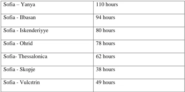
of travelers. In addition to this, these places were important for getting the animals rested; thus, they could cover long distance journeys. After these explanations, to make sense of travel time could be easier. Another example is that the distance between Sofia and Janina (Yanya) was 110 hours. Although it seems that this journey only took 5 days, in reality it could take a month by taking into account the travel time only in daytime. Other examples will be given in the following table:
Table 1. The Distances between Sofia and Other Sandjaks 83
Sandjaks of Eyalet of Rumelia Travel time
Sofia - Köstendil 14 hours
80
Kılıç, Osmanlı Devleti’nin İdari Taksimatı, 45.
81 Yusuf Halaçoğlu, Osmanlılarda Ulaşım ve Haberleşme (Menziller) (Ankara: PTT Genel Müdürlüğü Yayınları, 2002).
82 Cengiz Orhonlu, Osmanlı İmparatorluğunda Derbend Teşkilatı (İstanbul: Eren Yayıncılık, 1990). 83 Table 1: The following distances were taken from the maps of Erkan-ı Harbiye-i Umumiye Dairesi. “Memalik-i mahruse-i şahane’nin havi olduğu bilad ve mevaki-i askeriyye beynindeki yollar ile bilad ve mevaki-i mezkurenin yek diğerine olan mikdar-ı mesafesini saat hesabı ile irae iden işbu turuk ve mesafat haritası saye-i terakkiyat- piraye-i cenab-ı hilafet- penahide Erkan-ı Harbiye-i Umumiye Dairesi 4. Şubesince tertib olunarak daire-i mezkure matbaasında tab olunmuştur. Sene h. 1309- m. 1891/1892.”
33
Sofia – Yanya 110 hours
Sofia - Ilbasan 94 hours
Sofia - Iskenderiyye 80 hours
Sofia - Ohrid 78 hours
Sofia- Thessalonica 62 hours
Sofia - Skopje 38 hours
Sofia - Vulcıtrin 49 hours
Secondly, we will evaluate the road network in the kada of Sofia. The sandjak of Sofia consisted of four kadas which were Sofia, Berkofce, Sehirköy and Samakov and there were two nahiyes (sub-districts) Ihtiman and Iznepol. The distances between the sandjak of Sofia and its kadas will be given in the Table 2.
Table 2. The Distance Between Sandjak of Sofia and Its Districts and Sub- districts
The districts and sub-districts of sandjak of Sofia
Travel time
Sofia - Sehirköy 16 hours
Sofia - Berkofce 18 hours
Sofia - Samakov 9 hours
Sofia - Iznepol 16 hours
Sofia - Ihtiman 9 hours