OBSIDIAN, TRADE AND SOCIETY IN THE CENTRAL ANATOLIAN NEOLITHIC A Master‟s Thesis by FEVZİ VOLKAN GÜNGÖRDÜ Department of
Archaeology and History of Art Bilkent University
Ankara
OBSIDIAN, TRADE AND SOCIETY IN THE CENTRAL ANATOLIAN NEOLITHIC
The Institute of Economics and Social Sciences of
Bilkent University
by
FEVZİ VOLKAN GÜNGÖRDÜ
In Partial Fulfillment of the Requirements for the Degree of
MASTER OF ARTS in
THE DEPARTMENT OF
ARCHAEOLOGY AND HISTORY OF ART BİLKENT UNIVERSITY
ANKARA
I certify that I have read this thesis and have found that it is fully adequate, in scope and in quality, as a thesis for degree of Master of Arts in Archaeology and History of Art
---
Assistant Prof. Dr. Thomas Zimmermann Supervisor
I certify that I have read this thesis and have found that it is fully adequate, in scope and in quality, as a thesis for degree of Master of Arts in Archaeology and History of Art
--- Assoc. Prof. Dr. İlknur Özgen Examining Committee Member
I certify that I have read this thesis and have found that it is fully adequate, in scope and in quality, as a thesis for degree of Master of Arts in Archaeology and History of Art
---
Assistant Prof. Dr. Jan-Krzysztof Bertram Examining Committee Member
Approval of the Institute of Economics and Social Sciences
--- Prof. Dr. Erdal Erel Director
iii
ABSTRACT
OBSIDIAN, TRADE AND SOCIETY IN CENTRAL ANATOLIAN NEOLITHIC
Güngördü, Fevzi Volkan
M.A., Department of Archaeology
Supervisior: Asst. Prof. Dr. Thomas Zimmermann
January 2010
The major scope of this thesis was a reappraisal of obsidian and trade connections in the Central Anatolian Neolithic, to what degree external relations shaped and altered the cultural setting of a community, and what other items can be identified as key agents in this multiregional interaction sphere. For that reason, well published model sites were chosen to investigate these issues. Major focus was then set on obsidian, with major sources located in Central Anatolia, indeed an ideal item to trace interregional relationships. Furthermore, the value of other items like flint, metals and certain small finds were reviewed to achieve a comprehensive picture of the mechanisms on Neolithic trade and exchange, and its effects on society and settlement policy.
iv
ÖZET
ORTA ANADOLU‟DA NEOLİTİK DÖNEMDE OBSİDYEN, TİCARET VE TOPLUM
Güngördü, Fevzi Volkan
Yüksek Linsans, Arkeoloji Bölümü
Tez Yöneticisi: Asst. Prof. Dr. Thomas Zimmermann
Ocak 2010
Bu tezin asıl amacı, Orta Anadolu Neolitiğinde obsidyenin ve ticaret ilişkilerinin rolünü, dış ilişkilerin toplulukların kültürel bağlamlarını ne derece belirlediğini ve değiştirdiğini ve bu çok bölgeli etkileşim dünyasında başka hangi maddelerin anahtar rolünü üstlendiğini araştırmaktır. Bu nedenle, bu sorunları irdelemek için iyi yayınlanmış model yerleşimler seçilmiştir. Daha sonra ana vurgu Yakın Doğu için ender bir madde olan, ana kaynakları Orta Anadolu'da bulunan ve aslında bölgeler arasındaki ilişkilerin izini sürmek için ideal bir madde olan obsidyenin üzerine konulmuştur. Ayrıca, çakmaktaşı, metaller ve belli başı küçük buluntuların değerleri de araştırılmış ve bu sayede Neolitik dönem ticaret ve madde değişimlerinin ve toplumlar ile yerleşim politikaları üzerindeki etkilerinin bütüncül bir resminin çizilmesine uğraşılmıştır.
v
ACKNOWLEDGEMENTS
I am grateful to Asst. Prof. Dr. Thomas Zimmermann, who advised on the subject of the thesis, and who directed and supported me during the process. His invaluable insight of the contents of this thesis helped me a lot.
I am also grateful to Assoc. Prof. Dr. İlknur Özgen, who directed and encouraged me considerably, not only about this thesis, but also about my academic life in general.
I am indebted to Asst. Prof. Dr. Jan-Krzysztof Bertram for sharing his experience with me during my thesis research, and for the support he provided.
Lastly, I would like to thank my family and my friends – Mert Karaalioğlu, Gülşen Karaca, Polat Ulusoy, Müge Durusu, Zülfikar Akyüz, Cem Tunçbilek and Mert Çatalbaş for their help and support.
vi
TABLE OF CONTENTS
ABSTRACT ... iii ÖZET... iv ACKNOWLEDGEMENTS ... v TABLE OF CONTENTS... vi LIST OF FIGURES... x CHAPTER 1: INTRODUCTION ... 1CHAPTER 2: GEOGRAPHICAL SCOPE OF THE THESIS ... 5
CHAPTER 3: TRADE ... 7
CHAPTER 4: OBSIDIAN DEFINITION AND ARCHAEOMETRICAL APPLICATIONS... 11
4.1 X-Ray fluorescence spectrometry (XRF) ... 15
4.2 Particle included X-ray emission analysis (PIXIE) ... 16
4.3 Electron microprobe analysis (EMPA) ... 16
4.4 Instrumental neutron activation analysis (INAA) ... 16
4.5 Inductively coupled plasma emission spectroscopy (ICP) ... 17
4.6 Atomic absorption spectroscopy (AAS) ... 17
CHAPTER 5: OBSIDIAN SOURCES IN ANATOLIA ... 18
vii
6.1 Location ... 25
6.2 Geographical Setting ... 25
6.3 Stratigraphy and Chronology ... 25
6.4 Architecture ... 27
6.5 Burial Practices... 27
6.6 Fossil Records ... 28
6.7 Chipped Stone Industry ... 28
6.8 Small Finds ... 30 6.9 Non-Local Materials ... 31 CHAPTER 7: MUSULAR... 32 7.1 Location ... 32 7.2 Geographical Setting ... 32 7.3 Chronology ... 33 7.4 Architecture ... 33
7.5 Chipped Stone Industry ... 34
7.6 Pottery ... 36
7.7 Fossile Records... 37
CHAPTER 8: KÖMÜRCÜ-KALETEPE OBSIDIAN WORKSHOP ... 38
8.1 Location ... 38
8.2 Geographical Setting ... 38
8.3 Stratigraphy ... 38
viii
CHAPTER 9: TEPECİK-ÇİFTLİK ... 41
9.1 Location ... 41
9.2 Geographical Setting ... 41
9.3 Stratigraphy and Chronology ... 42
9.4 Architecture ... 42
9.5 Burial Practices... 43
9.6 Ceramics ... 43
9.7 Chipped Stone Industry ... 44
9.8 Small Finds ... 44
CHAPTER 10: KÖŞK HÖYÜK ... 46
10.1 Location ... 46
10.2 Geographical Setting ... 46
10.3 Stratigraphy and Chronology ... 47
10.4 Architecture ... 47
10.5 Burial Practices ... 48
10.6 Ceramics ... 49
10.7 Chipped Stone Industry ... 49
10.8 Small Finds ... 50
CHAPTER 11: ÇATALHÖYÜK ... 52
11.1 Location ... 52
ix
11.3 Stratigraphy and Chronology ... 53
11.4 Architecture ... 54
11.5 Burial Customs ... 55
11.6 Chipped Stone Industry ... 56
11.7 Small Finds ... 58
CHAPTER 12: SYNTHESIS – DISCUSSION OF MATERIALS, TECHNOLOGIES AND ARCHITECTURE ... 59
CHAPTER 13: CONCLUSION ... 72
BIBLIOGRAPHY ... 74
APPENDICES ... 81
x
LIST OF FIGURES
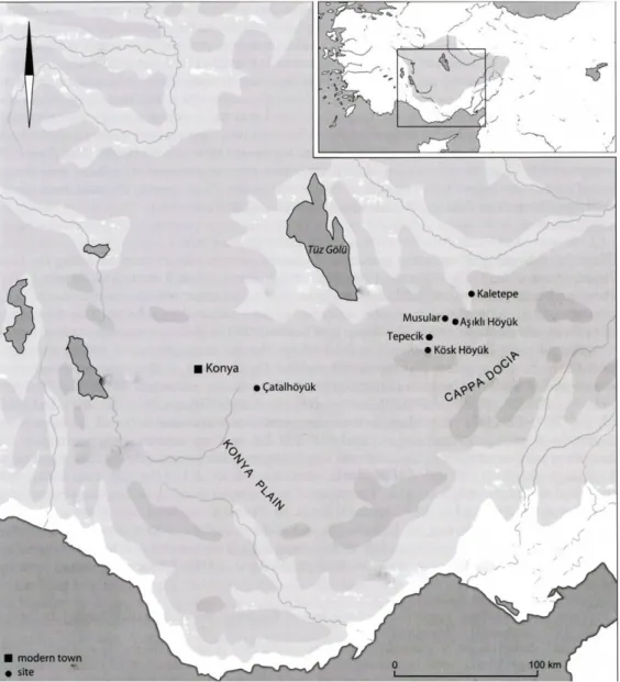
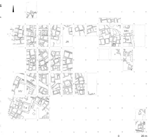
Figure 1. Map of Central Anatolian “model sites” mentioned in the text (Düring, B.
S. 2006) ... 81
Figure 2. Obsidian (Balkan-Atlı, N., Didier, B. 2007) ... 82 Figure 3. Location of the main obsidian sources in Anatolia and Transcaucasia
(Chataigner, C., Poidevin, J. L., Arnaud, N. O. 1998) ... 82
Figure 4. Central Anatolian Obsidian Sources (Chataigner, C., Poidevin, J. L.,
Arnaud, N. O. 1998) ... 83
Figure 5. Distribution of Obsidian from Göllü Dağ and Nenezi Dağ (Chataigner, C.,
Poidevin, J. L., Arnaud, N. O. 1998) ... 83
Figure 6. South-eastern Anatolian Obsidian Sources (Chataigner, C., Poidevin, J. L.,
Arnaud, N. O. 1998) ... 84
Figure 7. Distribution of Southeastern Anatolian obsidians (Chataigner, C.,
Poidevin, J. L., Arnaud, N. O. 1998) ... 84
Figure 8. Northeastern Anatolian Obsidian Sources (Chataigner, C., Poidevin, J. L.,
Arnaud, N. O. 1998) ... 85
Figure 9. Northern Anatolian Obsidian Sources (Chataigner, C., Poidevin, J. L.,
Arnaud, N. O. 1998) ... 85
Figure 10. Western Anatolian Obsidian Sources (Chataigner, C., Poidevin, J. L.,
xi
Figure 11. Aegean Obsidian Sources (Chataigner, C., Poidevin, J. L., Arnaud, N. O.
1998) ... 86
Figure 12. Caucasian Obsidian Sources (Chataigner, C., Poidevin, J. L., Arnaud, N. O. 1998) ... 87
Figure 13. Building Complexes of Aşıklı (Düring, B. S. 2006) ... 88
Figure 14. Building complex HV and T (Düring, B. S. 2006) ... 88
Figure 15. Red Painted Floor from Courtyard T (Esin, U.,Harmankaya, S. 2007) 89 Figure 16. Building Complex MI (Düring, B. S. 2006) ... 89
Figure 17. Burial Gifts from Aşıklı (Esin, U., Harmankaya, S. 2007) ... 90
Figure 18. Aşıklı Höyük Core examples: 1-6, 8. opposed platform cores, 7. Pyramidal core (Balkan-Atlı, N. 1994) ... 90
Figure 19. 1-6. Microliths, 17-23. Arrowheads (Balkan-Atlı, N. 1994) ... 91
Figure 20. 1-5. Pointed Blades, 6-12. Piercing Tools (Balkan-Atlı, N. 1994) ... 91
Figure 21. 1-7. Truncated Blades. 8-9/12. Alternately Retouched Blades, 10. Crossed Retouched Blade. 11-14,15. Steep Retouched Blades. 16. Retouched Blade (Balkan-Atlı, N. 1994) ... 92
Figure 22. Burins (Balkan-Atlı, N. 1994) ... 92
Figure 23. Copper Beads from Aşıklı (Esin, U., Harmankaya, S. 2007) ... 93
Figure 24. A Stone Plaque from Aşıklı (Esin, U., Harmankaya, S. 2007) ... 93
Figure 25. Stone Plaques from Jerf el-Ahmar (Stordeur, D., Jammous, B., Helmer, D., Willcox, G. 1996) ... 94
Figure 26. The Plan of Musular (Duru, G., Özbaşaran, M. 2005) ... 95
Figure 27. The Plan of the Building A (Özbaşaran, M., Duru, G., Kayacan, N., Erdoğdu, B., Buitenhuis, H. 2007) ... 95
xii
Figure 28. Arrowheads from Musular (Özbaşaran, M., Duru, G., Kayacan, N.,
Erdoğdu, B., Buitenhuis, H. 2007) ... 96
Figure 29. Musular Obsidian Tools: 1-2. Arrowheads, 3. Burin, 4. Borer, 5-6. Splintered Pieces, 7-8. Retouched Blades,). Scrapers. (Kayacan, N. 2003) ... 96
Figure 30. Flint Blades from Musular (Özbaşaran, M., Duru, G., Kayacan, N., Erdoğdu, B., Buitenhuis, H. 2007) ... 97
Figure 31. Kömürcü Kaletepe (Balkan-Atlı, N. 2000)... 97
Figure 32. Kaletepe Naviform Core and Unipolar Core (Balkan-Atlı, N. Didier, B., Cauvin, M.-C. 1999) ... 98
Figure 33. The Architecture of Tepecik-Çiftlik (Bıçakçı, E., Altınbilek-Algül, Ç., Balcı, S., Godon, M. 2007) ... 99
Figure 34. Neolithic Pottery (Bıçakçı, E., Altınbilek-Algül, Ç., Balcı S., Godon, M. 2007) ... 100
Figure 35. Chalcolithic Period Figured Pottery (Bıçakçı, E., Altınbilek-Algül, Ç., Balcı, S., Godon, M. 2007) ... 100
Figure 36. Neolithic Period Arrowheads (Bıçakçı, E., Altınbilek-Algül, Ç., Balcı, S., Godon, M. 2007) ... 101
Figure 37. Bone Idols (Bıçakçı, E., Altınbilek-Algül, Ç., Balcı, S., Godon, M. 2007) ... 101
Figure 38. Stamp Seal (Bıçakçı, E., Altınbilek-Algül, Ç., Balcı, S., Godon, M. 2007) ... 102
Figure 39. Köşk Höyük House Plan, Layer 2 (Öztan, A. 2007)... 102
Figure 40. Köşk Höyük House Plan, Layer 3 (Öztan, A. 2007)... 103
Figure 41. Wall Painting (Öztan, A. 2007) ... 103
xiii
Figure 43. Anthropomorphic Pottery (Öztan, A. 2007) ... 104
Figure 44. Figured Pottery (Öztan, A. 2007) ... 105
Figure 45. Figured Pottery (Öztan, A. 2007) ... 105
Figure 46. a. Spearhead from Layer 3, b. Arrowhead from Layer 1 (Öztan, A. 2007) ... 106
Figure 47. God and Goddess Figurines (Öztan, A. 2007) ... 106
Figure 48. Plan of the Level VIA (Düring, B. S. 2001) ... 107
Figure 49. Flint Dagger (Conolly, J. 1999a) ... 107
Figure 50. Map of the diffusion areas of the Central Anatolian Obsidians (green color), Phalanx Idols (blue color) and Spiral Decorated Stamp Seals (red color) .. 108
1
CHAPTER 1
INTRODUCTION
Central Anatolia obtains a special place within the vivid discipline of Near Eastern Neolithic Archaeology, since it has not been identified as being a significant area for the Neolithic period in the first half of the 20th century. Before the 1950‟s, it was generally assumed that Central Anatolia had not been settled before the Bronze Age. Seton Lloyd, for instance, asserted that the Neolithic period is restricted to the north by the range of the Taurus and the fringes of the Syrian plain, and that no communities settled down there before the beginning of the Early Bronze Age (Lloyd, 1956: 53, Düring, 2006: 8).
However, with the second half of the 20th century, the importance of Central Anatolia for Neolithic period became more and more obvious. Between 1950 and 1970, prehistoric studies on the Pre-Bronze Age sequence of Central Anatolia were carried out by mainly two British scholars: James Mellaart and David French. The former excavated at Hacılar between 1957 and 1960 and at Çatalhöyük between 1961 and 1965. David French, also affiliated with the British Archaeological Institute at Ankara, worked at Can Hasan I and III between 1961 and 1967. All these sites
2
with their architectural features and artifact assemblages contributed substantially to our understanding of the early and advanced Neolithic (Düring, 2006: 8).
Following these initial discoveries in the Konya plain and Southern Central Anatolia, the suspicion arose that some important Neolithic settlements might also be revealed in Cappadocia. Between 1964 and 1966, the Cappadocia region was surveyed by Ian Todd (Todd, 1980: 22), with an ever growing number of sites excavated until recent times. Here, the site of Köşk Höyük is another hallmark for understanding Neolithic activities in Central Turkey. Excavated between 1983 and 1991 by Uğur Silistireli, the Köşk Höyük expedition is currently maintained by Aliye Öztan after his sudden death (Öztan, 2007: 223, Düring, 2006: 9).
Moving further to the northeast, Aşıklı Höyük represents the major early Neolithic Centre of Central Anatolia. In 1989, Ufuk Esin initiated excavations at Aşıklı, dated to the Pre-Pottery Neolithic period with a densely clustered settlement type, intramural burials and many burial gifts (Duru, Özbaşaran, 2005: 15, Esin, Harmankaya, 2007: 268-269). In the immediate vicinity of Aşıklı, the small hamlet of Musular was unearthed by Mihriban Özbaşaran (Özbaşaran et al, 2007: 277-278, Düring, 2006: 10); the Kömürcü Kaletepe obsidian workshop, located likewise in the volcanic Aksaray basin, and a key feature for our thesis, was excavated by Nur Balkan Atlı, Didier Binder and Marie-Claire Cauvin between 1996 and 2003 (Balkan-Atlı, Binder, 2001: 1, Düring, 2006: 10). Finally Tepecik -Çiftlik, excavated since 2001 by Erhan Bıçakçı, contains both Late Neolithic and Chalcolithic layers (Bıçakçı et al., 2007: 238, Düring, 2006: 10).
While research activites in the Cappadocian region were intensified, the Çatalhöyük expedition was resumed in the Konya plain in 1993 under the
3
directorship of Ian Hodder, backed by an international excavation team. The new expedition attempts to get the maximum amount of information with different excavation, documentation and sampling techniques (Düring, 2006: 10, Hodder, 2007: 313-320, Cessford, Carter, 2005: 306).
For this thesis, these particular sites -Aşıklı Höyük, Musular, Kömürcü Kaletepe, Tepecik-Çiftlik, Köşk Höyük and Çatalhöyük- were chosen as “model sites”, since their sufficient publication portfolio helps to efficiently evaluate their finds and architectural features. Different materials like obsidian, metal beads, clay or bone idols, and the –at least in Central Anatolian contexts, as it seems- so far rather “marginally” discussed flint, will be technologically and typologically surveyed regarding their significance for the emergence -and eventual spatial shifts- of a multiregional trade and exchange network.
That said, Central Anatolia is an important region for a variety of important raw materials that were consumed at least since Neolithic times. The Cappadocia region, for example, hosts substantial obsidian sources (Todd, 1980: 30), a much sought material for tool making due to its ideal knapping qualities (Moorey, 1994: 64). Most significant, however, is the “fingerprint quality” of obsidian, since it is geochemically possible to identify its specific source and track down the movement of prefabrics and finished objects over sometimes considerable distances (Andrefsky, 2000: 41-42).
One major task will be to reevaluate the role of obsidian in context with selected Central Anatolian Neolithic sites, to understand the (shifting) dynamics of interregional relationships between Central Anatolia and remote Near Eastern and Mediterranean regions like Syria, the Levant, Cyprus, and Central Anatolia.
4
Conclusively, by means of a careful reevaluation of the material record of selected Central Anatolian Neolithic sites, its consumption and interregional distribution, it is attemped to reappraise interactions between Central Anatolia and other neighboring or remote regions, also attempting to sketch non material based interregional transfer like the communication of certain technical skills.
Finally, the results are tested whether they could serve as jigsaw pieces to understand the social grouping in larger Central Anatolian Neolithic communities.
5
CHAPTER 2
GEOGRAPHICAL SCOPE OF THE THESIS
Central Anatolia offers an ideal area for studying the interregional relationships in the Neolithic period, since it hosts a growing number of well excavated and published “model sites”, illustrating the cultural significance of Central Anatolia as being more than only a mere brigde that passively channels interaction between East and West. The region of Central Anatolia is bound at the north by Artova, Çorum and Çankırı, at the south and southeast, Karaman, Niğde and Çankırı, and at the west, Ankara and Konya (Todd, 1980: 18). Central Anatolia is bordered by two mountain ranges; in the south by the Taurus and in the north by the Pontus Mountains (Düring, 2006: 4).
Two arid regions, The Konya Plain and the Tuz Gölü plain, are contrasted by Beyşehir region and the Cappadocian plateau, which are wetter areas with an average 450mm/yr precipitation rate (Kuzucuoğlu, 2002: 38).
Despite the fact that Central Anatolia is a large area, the scope of this thesis is limited primarily to the Konya plain and the region of Cappadocia (Figure 1), last but
6
not least due to the fact that Central Anatolian Neolithic sites indeed only occur so far in Konya plain and the region of Cappadocia (Düring, 2006: 5).
Between the 9th and mid 7th millennium BC, South Central Anatolia was dry and humidity was increasing while the vegetation remained steppe and desert steppe. In the second part of the 7th millennium BC a forest expansion has been attested. In the 6th millennium BC humidity increases in the Konya plain, and vegetation grows on forested slopes. Vegetation in the Cappadocia region shows a general variability of woodlands and open grasslands (Kuzucuoğlu, 2002: 43-45).
7
CHAPTER 3
TRADE
One major aspect of this thesis is to critically review the external relations of selected Central Anatoltian sites. Therefore, a brief overview on selected common theories about trade and exchange policies should be provided, keeping in mind that the absence of writing systems makes it often difficult to reveal the true nature, intensity and scope of these contacts (Renfrew, 1969: 151). Some of the following models are sure enough highly arbitrary, and should - in the context of this thesis- be understood as a humble theoretic backdrop and not a golden path to reveal the mechanisms of Neolithic enterprise.
Trade is an integral and indispensable part of the human evolution and human behavior (Mauss, 1990: 71-78, Oka, Kusimba, 2008: 3), since it paves the way for innovation and progress through social interaction. People learn new ideas, new attitudes or new techniques from other people. Agriculture, for example, appeared independently in different parts of the world. Sure enough there are different reasons for the appearance of agriculture such as environmental change, population pressure or limited regional interaction between hunter-gatherers and foragers. But people are supposed to mainly learn new economic strategies from different social groups as a result of interregional migration (Asouti, 2006: 87).
8
(Archaic) trade, however, as “the mutual appropriative movement of goods between hands” defined as a reciprocal activity, involves two people, two social groups or more, with agreement being a necessity and as an appropriative movement (Renfrew, 1993: 6).
Trade must be satisfactory for all sides, since it literally happens “between hands” (Renfrew, 1969: 151, quoting Polyani). Regarding the absence of today‟s technology, in prehistoric times all the members involved in the trade activity physically “see” each other. As a matter of fact, with the archaic form of trade not only materials or commodities are exchanged, but also people from different cultures interact with each other. This might lead to a reshaping of a culture as a final consequence (Oka, Kusimba, 2008: 1).
An important issue that will echo in our synthesis chapter is the theory of intervening opportunity: here, a competition between two or more trader groups using common sources makes some groups look for new trade strategies, if the trade process is not satisfactory for them anymore. This theory shows that trade does not have a solid character, and that strategies are changeable regarding the overall conditions (Bradley, 1971: 347-348).
A likewise well known commonplace is the political dimension of trade, like treated by Marx with political economy as the ruling of wealthy that generated inequality (Hirth, 1996: 204). This is complementary to the anthropological perspective that indicates unequal access to wealth and the power (Hirth, 1996: 205), condensed to a society divided into elites and labourers. Production and exchange are then two sides of the same coin which is controlled by elites (Hirth, 1996: 207). The identification of elites and labourers in prehistoric times, however, is a difficult issue.
9
Traditionally, archaeologists agree that elaborate architecture, or “prestige goods” like obsidian, copper or marble, can be significant features, assuming that who resides in or possesses one of them also obtains a high position in society. According to Polanyi, long distance trade and the control of this organization require a central political organization (Hirth, 1996: 207). Although it is sure enough difficult to talk about something like a central political organization in the Pre-Pottery Neolithic, one has to accept the fact that the obsidian trade between Anatolian and Levant continued for several thousand years (Cauvin, 2000: 93). That said, at least some kind of administrative institution that control this trade mechanism seems to be plausible.
Referring to his studies on Melos Island in the Mediterranean, Colin Renfrew finally distinguishes between different “organizational zones”, basically sites that can be defined as a “supply zone” where materials were found, and a “contact zone” where items were exchanged (Oka, Kusimba, 2008: 8). For our thesis focus, Central Anatolia could be the conclusively be defined as a supply zone, since obsidian resources are located there.
Ultimately, Renfrew introduced some well-known models to explain cultural change (The invasionist, diffusionist, and evolustionist model, see Renfrew, 1969: 152). For our task, however, the “cultural process” model looks most attractive, since it emphasizes the crucial role of trade in the overall process. In this particular approach, proficient and favourable exchange encourages production, which eventually becomes more efficient and specialized. Trade further on establishes contact between communities and the physical swap of ideas through personal communication. So trade produces new request to finally generate new commodities (Renfrew, 1969: 153-154).
10
Finally, the trafficking of materials surely coincides not only with the spread and adaption of “foreign” customs, architecture, and settlement patterns (Bar-Yosef and Belfer-Cohen, 1989: 65), but even profound manifestions like new belief systems (Cauvin, 2000, 25-32). Such a groundbreaking change is suggested for the PPN B period, and with trade as a motor and catalyser, elements of the “Neolithic lifestyle package” were diffused to Western Asia, triggering off acculturation (Adams et al. 1974: 240; Asouti, 2006: 88).
11
CHAPTER 4
OBSIDIAN: DEFINITION AND ARCHAEOMETRICAL
APPLICATIONS
To locate materials that are unique to some specific regions, but absent as a raw material in other regions, however present in the archaeological record, is the most prominent method to understand the mechanisms of trade and cultural communication between remote regions in prehistoric times. Obsidian, whose origin can be determined with various scientific analysis methods (infra), is a common and well researched item to understand the multifaceted relationships between Neolithic cultures. Obsidian, known in literature since Pliny‟s Natural History and named after a Roman Obsius who eventually recognized it in Etiopia, is a type of glass which emerges in course of volcanic activity (Figure 2) (Balkan-Atlı, 2008: 191). The chemical configuration of obsidian, actually a derivate of our known glass with 70% silicon dioxide, is related with rhyolite and granite, and contains also large amounts of non-silicious materials such as quartz (Balkan-Atlı, 2008: 191; Whittaker, 1994: 69). The immediate, yet rapid cooling of molten rock after a volanic eruption, as in Pleistocene periods or winter months, is the main prerequisite for the emergence of obsidian (Whittaker, 1994: 69). The global occurance of substantial obsidian deposits is limited to Hawaii, Japan, Iceland, Hungary, Italy, Greece, Turkey, Armenia, Ethopia, Mexico, Ecuador, Arizona and New Mexico (Balkan-Atlı, 2008: 191).
12
Obsidian is generally black or green in color (Moorey, 1994: 63-64). These colors result from the oxidation state of the chemical elements within the very small minerals. For instance black color is related with magnetite. If the obsidian is very much oxidized, then the glass may include hematite, which gives obsidian a reddish color. If volcanic glass contains iron, it tends to have a greenish sheen (Balkan-Atlı, 2008: 191).
In nature we see obsidian in large massive flows, particularly as lumps or beds in rhyolite flows. Extracting pieces of obsidian from an original deposit is rather difficult, which is the reason why prehistoric knappers gathered material from secondary sources such as talus slopes and streambeds. In these places knappers could get “secondary” chunks or nodules due to the eroding of the original source (Whittaker, 1994: 69).
Pending its geologically determind quality, obsidian is an ideal raw material, preferrably for tool production. Since it is more delicate than many other materials and provides a fine cutting edge, it is easier to produce the desired form, for instance a blade or arrowhead, hunting equipment or butchering tools (Moorey, 1994: 64).
Listed below is the common vocabulary of obsidian production techniques and shapes.
13
Bevelled: Defines a tool edge which is modified by the removal of a series of flakes in order to manufacture a desired edge angle.
Biface: Biface is a tool that contains two surfaces which get together to form a single edge which identify the tool. Both faces generally have flake scars which are located at least half-way across the face.
Bifacial thinning flake:
These kind of flakes are removed with biface cutting. Generally they have a significant platform which is rounded or ground.
Bipolar flake: A bipolar flake is a detached piece that is formed by compression forces. Bipolar flakes usually contain signs of impact on opposing ends and have compression rings which are moving it two directions toward one another.
Bipolar technology:
A technique of resting the objective piece on an anvil and striking it with a hammer to split or remove a detached piece.
Blank: A blank is a detached piece which can be transformed into a specific tool.
Collateral flaking:
Removal of expanding flakes which are separated from the lateral margins of an objective piece at right angles through the longitudinal axis.
Conchoidal fracture:
Defines the manufacturing of smooth convexities or concavities, which is like clamshell after fracturing.
Conchoidal flake:
A conchoidal flake has the features of conchoidal fracture. They have a dorsal and ventral surface.
Core: A core is a mass of rock that shows the marks of detached piece removal. Cores are like a source for detached pieces.
Core tool: Actually this is a core, but used as a tool for chopping, cutting or other activities. It is not a source for detached pieces.
14
Detached piece:
A piece of rock which is removed from an objective as a result of percussion or pressure. These are often referred to as flakes, spalls, chips, and debitage.
Diagonal parallel flaking:
The process is similar to parallel flaking however the flakes are removed at an oblique angle to the piece edge.
Microlith: A microlith is a small blade which is basically geometric in form used for composite tools.
Parallel flaking:
A method of striking with a percussor to detach flakes from an objective piece. Different methods of percussion flaking using different kinds of percussors tend to produce distinctive detached pieces.
Pressure flaking:
In this process a detached piece is removed by pressing rather than percussion.
(Andrefsky 2000: XXI-XXVII)
The history of scientific obsidian studies is a fairly recent subject in archaeology. Early endeavours comprise macroscopic observations, density measures and mass spectrometry, all applied to define source groups and establish a link between possible sources and artefacts. At the end of the 1960s and the beginning of the 1970s, X-ray fluorescence and Neutron Activation Analysis were intruduced to obsidian studies, here already applied to highlight interregional exchange, trade patterns and interaction. Since the 1980s, obsidian studies are generally increased, and maintained with considerable intensity in any part of the world were obsidian occurs (Shackley, 2008: 199).
15
Geochemical analysis techniques are applied to characterise obsidian. These techniques provide the identification of the elemental composition of the artifacts, and give the proportion of varied elements such as barium, sodium, manganese, or dysprosium in the sample. These elements provide the “fingerprint” that allows to determine where the raw material for the artifacts comes from (Andrefsky, 2000: 41-42, Leute, 1987: 101), hence the key issue to identify and reconstruct the travelling of volcanic glass.
There are different geochemical analysis techniques: Each of them provides a different type of information but also each of them requires a different kind of sampling. Some techniques scan only on the outer surface, other approaches require the destruction of the whole sample (Andrefsky, 2000: 42). Their brief description should suffice to render an impression of their capabilities and limitations.
4.1 X-Ray fluorescence spectrometry (XRF)
This technique only evaluates the surface of the sample, since it penetrates it just about 200 microns. Sometimes samples are crushed to powder in order to analyze the whole sample, not only the surface of it (Andrefsky, 2000: 42).
During the XRF scanning, the sample is irradiated by an X-ray beam. This irradiation excites electrons to a high level. After that electrons settle back and emit a secondary of fluorescent X-rays. These X-rays yield characteristic wavelengths of different elements. While measuring the intensity of X-rays at different wavelengths, it is possible to evaluate concentration of different elements in the sample, minding the eventually changing surface characteristics in different areas (Andrefsky, 2000: 42-43).
16
4.2 Particle included X-ray emission analysis (PIXIE)
PIXIE technique is very similar to XRF, since they are based on the same kind of electron excitement and emission. Here the beam only focuses on a relatively small area, and not the entire surface. One has to polish the surface of the sample carefully to get reliable results, eventually doing harm to the surface of the sample (Andrefsky, 2000: 43).
4.3 Electron microprobe analysis (EMPA)
This application is considered to be the most comfortable method of elemental analysis, since one can manage to analyse single crystals without any destruction of the rock‟s texture. It is furthermore possible to apply this technique to a complete artifact or a sample from an artifact. During the EMPA processing, the sample is scanned with an electron beam which causes the mineral to emit secondary X-rays, measured in the same manner as with X-Ray Fluorescence (Andrefsky, 2000: 43).
4.4 Instrumental neutron activation analysis (INAA)
In this technique the sample is irradiated in a nuclear reactor by an extended neutron bombardment. It this process some elements undergo nuclear reactions, producing radioactive isotopes and an amount of gamma photons. This technique is non destructive but useless for big specimens, however a high accuracy is guaranteed (Andrefsky, 2000: 43).
17
4.5 Inductively coupled plasma emission spectroscopy (ICP)
While applying ICP, a solution of the sample is heated to about 6.000 degrees until it is transformed to plasma. The solution is injected into argon and heated with a radiofrequency coil. The emission spectrum is analyzed in order to show the elements and their relative concentrations. Its advantage is that the procedure requires only 00.3 g of sample (Andrefsky, 2000: 44).
4.6 Atomic absorption spectroscopy (AAS)
In the process of AAS, the sample is crushed, put into a solution and sprayed into a flame with the compounds in the sample separating their atoms. The light spectra of the characteristic wavelength of the element can be evaluated according to the flame colours, revealing the concentration of each element (Andrefsky, 2000: 44).
18
CHAPTER 5
OBSIDIAN SOURCES IN ANATOLIA
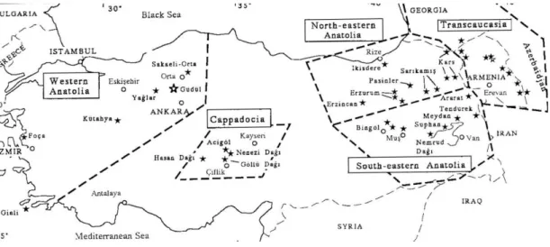
Near Eastern obsidian deposits have a rather clearly defined distribution pattern. All the obtainable sources in Turkey, the Caucasus and some Aegean islands are clustered in areas with ancient volcanic activity (Figure 3). In our case, Caucasian sources are less relevant for Near Eastern Neolithic studies due to the fact that these sources were used predominantly within the limits of Transcaucasia, albeit a few exchanges happened with the neighboring regions. Hence, Anatolia and its obsidian deposits are the key areas for studying Neolithic interactions (Chataigner, Poidevin, Arnaud, 1998: 518).
In terms of location, obsidian sources in Anatolia can be separated into several different groups: Central Anatolia, Southeastern Anatolia, Northeastern Anatolia, Northern and Western Anatolia. Colin Renfrew attempted to classify Anatolian obsidian sources regarding their element composition and concentration (Renfrew, Dixon, Cann, 1966: 33):
Group 1: This group, which can be further subdivided into three subgroups,
comprises sources in Cappadocia (Karakapu-Hasan Dağ, Acıgöl) and East Anatolia (Kars), and contains a high percentage of Barium and low or sometimes moderate percentages of Zirconium (Renfrew, Dixon, Cann, 1966: 33).
19
Group 2: High barium (200ppm) and low zirconium (30ppm) are the features
of group 2b. This group is represented in the source of Çiftlik in Cappadocia (Renfrew, Dixon, Cann, 1966: 33).
Group 3: This cluster contains generally higher zirconium and barium rates,
and is related with northeastern Anatolian sources (Renfrew, Dixon, Cann, 1966: 33).
Group 4: This group contains barium less than 30ppm and zirconium up to
1000ppm. In the Near East it has 3 sub-groups; 4c is related with Nemrut Dağı deposits and 4f is represented by Karnıyarık Kepez in Cappadocia (Renfrew, Dixon, Cann, 1966: 33-34).
In Central Anatolia, obsidian outcrops are located in the provinces of Nevşehir, Niğde and east and south-east of the south end of the Tuz Gölü (Figure 4) (Todd, 1980: 30). Kaleiçi, Acıgöl, Güneydağ, Kocatepe-Acıgöl and Hotamış Dağ are the known obsidian sources in the Acıgöl area (Todd, 1980: 30), with the 25-16 million year old Acıgöl and Çiftlik deposits being the geologically oldest obsidian beds in Anatolia (Ercan, Şaroğlu, Kuşcu 1994: 506).
Obsidian sources in the Göllü Dağ region (Niğde, Melendiz plain) are known from the Kömürcü Köyü area, Sırça Deresi and Kayırlı (Todd, 1980:33).
Chemical analyses show that Göllü Dağ obsidians can be separated into two groups (Chataigner, Poidevin, Arnaud 1998: 525); Göllü Dağ-East contains domes and dome-flows, which were diffused to numerous archaeological sites in Syria and Levant (Chataigner, Poidevin, Arnaud, 1998: 525), but also used by the Aşıklı Höyük community itself in the 8th
millennium BC. With the beginning of pottery use (6.000-5.000 BC), Göllü Dağ obsidians were widely diffused to places such as Çatalhöyük and Mersin. After 5.000 BC, we witness a shift to the west of Anatolia,
20
for instance the Marmara region (Fikirtepe, Pendik and Ilıpınar) and the Aegean littoral (Sivri Tepe) (Chataigner, Poidevin, Arnaud, 1998: 525). Few examples from Cyprus (six specimens from Khirokitia, dated to about 7.700 BC) provide furthermore evidence for maritime trade (Figure 5) (Renfrew, Dixon, Cann, 1968: 325).
Göllü Dağ-West obsidian, on the contrary, has a limited diffusion because of its lower quality (it fractures easily), albeit some examples were found in Aşıklı Höyük (Chataigner, Poidevin, Arnaud, 1998: 526).
Nenezi Dağ (Acıgöl district) (Todd, 1980:34) bears a high dome with a large obsidian flow on its western bank. We have many examples from Turkey, Cyprus and Israel where obsidian of this particular source was identified (Figure 5), (Chataigner, Poidevin, Arnaud, 1998: 523-524).
Hasan Dağ also has some, however highy poisonous Barium-rich obsidian sources (Karakapı and Tahtayayla) (Ercan, Şaroğlu, Kuşcu, 1994:506), but these deposits were obviously never exploited in prehistory (Chataigner, Poidevin, Arnaudi 1998: 526).
(South)east Anatolia has likewise rich obsidian sources (Figure 6) which were used by many Neolithic communities (Figure 7) (Chataigner, Poidevin, Arnaud 1998: 529).
In the Bingöl area obsidian is generally gray and black, rarely green and red in color. Çatak, Alatepe and Çavuşlar regions are the important obsidian bends in this area (Ercan, Şaroğlu, Kuşcu, 1994: 506).
21
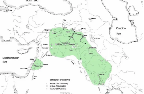
Geochemically, Bingöl obsidians can be separated into two groups, namely Calc-alkaline and per-alkaline sources (Chataigner, Poidevin, Arnaud, 1998: 529). Calc-alkaline sources extend almost all the way throughout Turkey. On the contrary, per-alkaline specimens are found only in the region of Bingöl and Nemrut Dağı (Cauvin, Chataigner, 1994: 529). Bingöl calc-alkaline deposits were widely diffused: Hallan Çemi examples are dated to 10.600 BC, and in 10.300 BC Middle Euphrates sites such as Cheikh Hassan and Mureybet, and Tell Aswad in the Damascus region contain Bingöl calc-alkaline obsidians. In 9.600 BC, Bingöl calc-alkaline examples were diffused to the Zagros region such as Shimshara, Jarmo and Ali Kosh. Bingöl calc-alkaline examples were found in the Middle Euphrates and the upper Mesopotamia- Zagros region until the Halaf Period (ca. 6.500-5.500 BC). After this period this source was likely supplanted by another eastern Anatolian source. At about 6.000 BC, Bingöl calc-alkaline examples diffuse into the Levant such as Byblos and Abu Zureig. Afterwards, this source reappeared again in the upper Euphrates area (Değirmentepe), with its presence attested as far as Uruk in southern Mesopotamia (Chataigner, Poidevin, Arnaud, 1998: 529).
In contrast, Bingöl per-alkaline deposits have again a limited diffusion. In 7.600 BC, the upper Tigris region (Çayönü) and upper Euphrates (Cafer Höyük) revealed some Bingöl per-alkaline examples (Chataigner, Poidevin, Arnaud 1998: 530). Some specimens are reported from Cafer Höyük (Malatya province, dated to 7.300-6.500 BC) which were archaeometrically analyzed, revealing that all examples are from Bingöl (Bigazzi, et al.1998: 83). Çayönü examples show that they are both from Bingöl and Lake Van obsidian sources (Bigazzi et al. 1998: 83). The diffusion of those is traceble in northwestern Iraq until 6.600 BC, with Magzalia being a reference findspot. In Yarim Tepe II and the middle Euphrates (Tell Halula), the
22
diffusion continued until the late 6th millennium BC. In 4.000 BC, on the upper Euphrates, Değirmentepe (cf. supra) yielded Bingöl per-alkaline examples (Chataigner, Poidevin, Arnaud, 1998: 530/532).
Continuing or survey of East Anatolian obsidian deposits, Nemrut Dağı volcanic glass sure enough counts amongst the most prominent sources in prehistory. It remained to be an active volcano until AD 1441, so far the latest volcanic eruption in Anatolia (Ercan, Şaroğlu, Kuşcu, 1994: 505).
Nemrut Dağı obsidian has been identified at many archaeological sites from the Neolithic to the Bronze Age. Reviewing the evidence from southwest Syria (Tell Aswad), the diffusion of the materials started in about 8.300 BC (Chataigner, Poidevin, Arnaud, 1998: 533). Nemrut examples are present also in the northern Zagros (Paleolithic Shanidar and Epipaleolithic Zarzi). In Anatolia, Çayönü, Cafer Höyük and Hallan Çemi also contain Nemrut examples. In the Jordan valley and the Levantine coastal zone, Nemrut obsidians are found around 4.500 BC, such as in Munhata and Abu Zureig (Chataigner, Poidevin, Arnaud, 1998: 533). Southern Mesopotamia (Ubaid and Larsa) yielded likewise Nemrut obsidian, with single artefacts reaching as far as the western banks of the Persian Gulf (Chataigner, Poidevin, Arnaud, 1998: 533).
Sources that were mainly, if not exclusively used only locally include the geochemically still not very well attested Süphan Dağ obsidian (Ercan, Şaroğlu, Kuşcu, 1994: 505; Chataigner, Poidevin, Arnaud, 1998: 534) and volcanic glass from Ziyaret Dağı (with at least few specimens attested in Upper Mesopotamia), all of them located in the vicinity of Van Gölü (Chataigner, Poidevin, Arnaud, 1998: 534).
23
Northeastern Anatolia also has some obsidian sources, mainly located in the vicinitiy of Erzincan, Erzurum, Pasinler, Sarıkamış, Kars and İkizdere (Figure 8) (Ercan, Şaroğlu, Kuşcu, 1994: 506; Chataigner, Poidevin, Arnaud 1998: 526). These sources were exploited by Chalcolithic and Early Bronze Age communities of the Bayburt and Erzurum areas, such as Sos Höyük, Pulur, Büyük Tepe and Gundulak. (Chataigner, Poidevin, Arnaud, 1998: 529).
Northern Anatolia also yielded some obsidian sources which are located north and northwest of Ankara, namely Yağlar, Sakaeli-Orta and so-called Galatia-X (Figure 9) (Chataigner, Poidevin, Arnaud, 1998: 520; Bigazzi, Poupeau, Yeğingil, Bellot-Gurlet, 1998: 74). The Galatian-X source is not a source that is spatially identified, hence its odd designation. Eight chips of worked obsidian, lacking further archaeological context, had been collected on the surface near the village of Güdül, 40 km. northwest of Ankara (Bigazzi, Pouoeau, Yeğingil, Bellot-Gurlet 1998: 86). According to XRF and INAA analysis, these eight samples bear chemical features are clearly different from all the other Anatolian obsidian sources (Keller, Bigazzi, Pernicka, 1994: 545). The chemical composition of the Güdül artefacts testifies to a homogenous group which shows that this Galatia-X source is clearly distinguishable from the two other Galatian sources, like Yağlar and Sakaeli-Orta (Keller, Bigazzi, Pernicka, 1994: 549). Galatia-X possibly derives from the Galatian volcanic complex, but has not been recognized yet, since it is possibly buried under alluvium or it has been exhausted through exhaustive exploitation (Bigazzi, et. al.1998:, 1998: 86).
Yağlar and Sakaeli-Orta sources were used by some Neolithic villages in the Marmara focus, such as Fikirtepe, Pendik and Ilıpınar (Chataigner, Poidevin, Arnaud, 1998: 523).
24
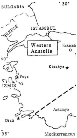
There are some small deposits in Kütahya, Kalabak Valley (near Eskişehir) and Foça (north of the İzmir) (Figure 10). The deposit samples indicate that these sources are not good for tool making (Chataigner, Poidevin, Arnaud, 1998: 523), since they are too much fragile (Bigazzi, et. al.1998: 1998: 74).
Some obsidian sources are also known from regions neighboring Anatolia. Aegean obsidian sources are located in Melos, Antiparos and Gilai (Figure 11), with Antiparos deposits presumably not having been exploited in prehistoric times. Gilai obsidian source has a restricted distribution in Middle Bronze Age or later eastern Aegean and Cretan communities. Analyses show further on that Troia and Beşiktepe obsidians are related with the source of Adhamas on the Cycladic island of Melos (Pernicka et. al.1994: 515).
Finally, the Caucasus bears some obsidian sources, namely Arteni, Atis, Gutansar, Spitaksar, Choraptor, and The Sjunik group (Bazenk, Sevkar, Satanakar) (Figure 12) (Keller et. al. 1996: 70-72). Almost exclusively used by Transcaucasian communitites, few exceptions prove that Chalcolithic Arslantepe and Tal-e Malyan in Southern Iran benefitted from Caucasian obsidians (Keller et al.1996: 75).
In the following chapters, the chronology, architecture and artifact assemblages of selected “model sites” referred to in the introductionary chapter will be presented and discussed, to provide the material foundation for further discussions concerning lithic technologies, trade and social issues. Our survey starts with Aşıklı Höyük, a large Pre Pottery settlement in the Aksaray district. Musular, the Kömürcü-Kaletepe workshop, Tepecik-Çiftlik, Köşk Höyük and Çatal Höyük then follow a similar descriptive pattern.
25
CHAPTER 6
AŞIKLI HÖYÜK
6.1 Location
Aşıklı Höyük is located in the province of Aksaray, approximately 25 km southeast of the provincial center (Figure 1) (Esin, Harmankaya, 1999: 117).
6.2 Geographical Setting
The Melendiz valley is known as a fertile and varied environment. The site was subject to erosion due to the impact of the Melendiz River especially at the northern, eastern and southern edges of Aşıklı Höyük. Today Aşıklı Höyük is sized 4ha, but it was possibly larger in the Neolithic (Düring, 2006: 72).
6.3 Stratigraphy and Chronology
Layers Phases Estimated calibrated dates
BC
1 - 7.500-7.400
2 2a-b-c-d-e-f-g-h-ı-j (10) 8.000-7.500
3 3 a-b-c (3) 8.200-8.000
26
The stratigraphy of Aşıklı Höyük consists of three main layers, which are named 1-3 from top to bottom. Layers 2 and 3 have some multiple building phases that are indicated by letters (Düring, 2006: 73; Esin, Harmankaya, 1999: 118).
Top soil agricultural activities disturbed Layer 1, which presumably destroyed most of its archaeological features (Esin, Harmankaya, 2007: 257). Layer 2 then bears the main cultural features of the Aşıklı Höyük Pre-pottery Neolithic culture (Düring, 2006: 73; Esin, Harmankaya 2007: 118-119). A flood horizon separates Layer 2 from Layer 3, which has similar building remains as Layer 2. The last two additional excavation seasons revealed a number of oval buildings under Layer 3, sub-phase C (Layer 3 has three sub-phases which are called a, b and c). However, it is not clear whether these oval buildings belong to Layer 3 or they indicate a new layer (Layer 4) (Düring, 2006: 73).
Although we have three main layers at Aşıklı Höyük, an additional settlement part was found next to the Melendiz River. This part must have been affected by a sudden flood due to the fact that it was inundated by a deep layer of gravel (Esin, Harmankaya, 1999a: 103). The architecture does not differ at all from Aşıklı Höyük‟s main layers. The inhabitants of Aşıklı probably left this area after the flood, and moved to the area where Aşıklı is located (Esin, Harmankaya, 2007: 256).
The accumulated 47 radiocarbon samples put Aşıklı Höyük 8.200-7.400 BC, hence the Pre Pottery Neolithic B (Düring, 2006: 73).
27
6.4 Architecture
A recently published reappraisal of Aşıklı Höyük‟s architecture (Düring, 2006) highlights the complex and sophisticated manner of Aşıklı‟s clustered rectangular mudbrick dwellings: Streets and alleys divide the settlement into blocks, while the clustered small domestic loam buildings (Esin, 2000: 22-24; Esin, Harmankaya, 2007: 268) remain in contrast to large monumental complexes, differing in many aspects like measurement, the number of rooms, internal courtyards, building technique and used materials (Figure 13-14-16) (Düring, 2006: 76; 101-102; Esin, Harmankaya, 2007: 263). Most significant are painted floors in building “T” (Figure 15), a rather unusual feature for domestic loam structures (Esin, Harmankaya, 2007: 263). Midden areas do also exist, containing the usual range of flaking debris, bone tools or other garbage, but are not published in detail yet (Düring, 2006: 76-77; Esin, Harmankaya, 2007: 258-262).
6.5 Burial Practices
Concurring with the general Neolithic tradition, the burial custom of Aşıklı Höyük is intramural. That said, with about 400 building units excavated, just 70 burials were found, which hardly represent the overall population that once lived here. There is no uniform burial position; sometimes individuals were buried in hocker, sometimes in dorsal position (Esin, Harmankaya, 1999: 126; Esin, Harmankaya, 2007: 265). Remarkable indeed are the results of physical anthropology, revealing that some bodies were fired before they were buried. Since wooden fragments were associated with some burials, this situation might indicate that the bodies were buried just after they were exposed to fire (Özbek, 1993: 201-208, Özbek, 1994: 27-28). This firing custom has been identified both for male,
28
female and children skeletons. Some examples show evidence for trepanation. Most enlightening is the observation that some deformations on female skeletons were identified on the neck and the backbones. Due to the fact that there are no deformation traces attested at male skeletons, the impression is rendered that females worked in hard conditions, like being obliged to carry heavy loads already at a young age (Özbek, 1993: 201-208, Özbek, 1994: 27-28).
6.6 Fossil Records
Animal bones and plant remains associated with Layer 2 testify to a subsistence that is still based on hunting and gathering. Although some domesticated plant examples are reported, the percentage of them is rather small (Esin, Harmankaya, 2007: 266).
6.7 Chipped Stone Industry
The chipped stone industry of Aşıklı Höyük mainly consists of obsidian. This is not surprising, since the mound is placed in a region rich in obsidian resources (Balkan-Atlı 1994: 209, Düring, 2006: 75).
Nenezi Dağ and Kayırlı obsidian sources supply the whole obsidian demand of Aşıklı Höyük. It seems like that the obsidian has been taken and brought to the site in the form of blocks, while the knapping itself was done at Aşıklı Höyük (Esin, Harmankaya 2007: 266, Balkan-Atlı 1994: 209, Düring, 2006: 75). However, the determination of the Aşıklı type cores at Kayırlı and also Nenezi Dağ show us that
29
the knapping process was also performed at these places, probably to avoid an extra weight and guarantee an easier transportation (Esin, Harmankaya, 2007: 266).
Aşıklı Höyük yielded two types of cores. The first is classified as the “opposed platform core” with two striking platforms on opposite sites, which is common in Aşıklı Höyük (Figure 18). Opposed platform cores were used for the production of blades by hard percussion technology. Neither pressure technique nor indirect percussion was identified in the knapping procedure. The other type is called “single striking platform core”, which has a pyramidal shape (Figure 18). These cores were used for flakes (Balkan-Atlı 1994: 209, Esin, Harmankaya, 2007: 266, Düring, 2006: 75).
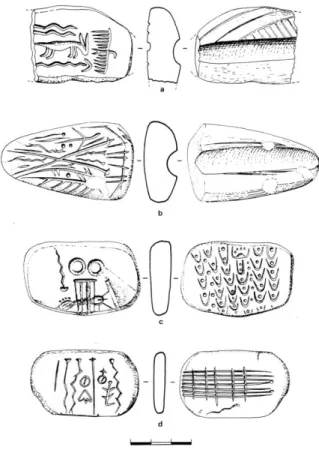
Microliths occur in varied forms, such as obliquely truncated bladelets (Figure 19: 9,11,14,16), pointed bladelets (Fig.7:10), rarely notched or denticulated bladelets (Figure 19: 15 ) in shapes of small triangles and lunates (Figure 19:1-8,12,13 ) (Balkan-Atlı, 1994: 215).
Arrowheads (see Figure 19 for an impression of their typological range) and piercing tools (Figure 20: 1-2) are fairly rare (Balkan-Atlı 1994: 215, Esin, Harmankaya, 2007: 266), while scrapers are the most abundant tool type in Aşıklı Höyük (Balkan-Atlı 1994: 215, Esin, Harmankaya 2007: 266). They can be categorized as simple end scrapers, double scrapers, semi-circular scrapers, and circular scrapers (Balkan-Atlı, 1994: 215).
Blades with steep, crossed or alternating retouch (cf. Figure 21), however small in percentage, also are attested at Aşıklı. (Doube-) truncated examples are rare, generally they are obliquely truncated (Figure 21: 1, 2, 5-7) (Balkan-Atlı, 1994: 221).
30
Although they are scarce, we also have some burin examples such as transverse burins (Figure 22: 8) and dihedral burins (Figure 22: 5) (Balkan-Atlı, 1994: 221).
The cores, microliths, points, piercing tools, scrapers, blades, and burins in Aşıklı Höyük testify to a considerable variety of lithic equipment. Microliths indicate that people retained some old Epi-Palaeolithic traditions (Binder, 2002: 83, Esin, 1994a: 87). The increment of the scrapers in Aşıklı Höyük from the old levels to the new levels show us the hunting and leather working activities increased periodically which seems to be related with a general increase of the Aşıklı Höyük‟s population (Esin, 1999a: 105). The overall impression of Aşıklı Höyük‟s lithic is that of a rather modest housework production (Binder, 2002: 84).
6.8 Small Finds
Burial gifts comprise necklaces and bracelets which contain pierced beads. These beads are made of copper, deer teeth semi-precious or simple stones (Figure 17) (Esin, 1999b: 27).
12 annealed copper beads (Figure 23) prove that native copper and malachite were used at Aşıklı Höyük for the production of the beads. Special studies indicate the so-called re-crystallistation of “twin structures” in native copper, which proves that annealing (the application of heat to ease the shaping of metal) was indeed carried out at Aşıklı Höyük as an experimental approach to metalwork. (Esin, 1999b: 29, Esin, 1995: 67).
31
Copper sources are known from Central Anatolia with deposits at Menteşe, Bakırlık, or Sızma (Esin, 1999b: 29), but located at least 250 km far from Aşıklı Höyük. However, Ufuk Esin suggests another source, “Bakır Çukuru” (Copper Hole), located only about 40 km southwest of Aşıklı Höyük, which might be – pending analytical studies of its chemical composition- a good candidate for the copper Aşıklı was supplied with. (Esin, 1999b: 29).
6.9 Non-Local Materials
Aşıklı Höyük contains a stone plaque that has been found near the northeastern section of the excavation. The external surface of this plaque was decorated with ”V” and “O” symbols (Figure 24). (Esin, Harmankaya, 2007: 269; Stordeur et al. 1996: 1-2). Due to its utmost significance to illustrate interregional connections, this item will be discussed separately in our Synthesis Chapter.
32
CHAPTER 7
MUSULAR
7.1 Location
Musular is located in Central Anatolia, Aksaray province, Gülağaç district, Kızılkaya Village (Figure 1) (Özbaşaran, 1999: 148). It is situated very close, only 300/400m west of Aşıklı Höyük (Özbaşaran, 2000a: 129).
7.2 Geographical Setting
In contrast to Aşıklı Höyük, Musular is a flat settlement. It is located above a volcanic tufa rock formation. The Melendiz stream, whose ancient riverbed is unknown, today flows between Aşıklı and Musular (Duru, Özbaşaran, 2005: 18). Musular is about 220 x 120 m in size (Kayacan, 2003: 3) and was heavily affected by modern agricultural activities (Özbaşaran, Endoğru, 1998: 200, Özbaşaran, 2000b: 47).
33
7.3 Chronology
Musular revealed Pre-Pottery Neolithic, Pottery Neolithic and Early Bronze Age materials. The Pre-Pottery Neolithic of Musular is radiocarbon-dated to the mid 8th millennium BC (Özbaşaran et al., 2007: 274), the -due to erosion and modern agriculture- badly preserved pottery Neolithic, pinned down with only one single 14C-date, hovers with some uncertainly within the final quarter of the 6th millennium BC (Özbaşaran et al. 2007: 278, Özbaşaran, 2000b: 131).
7.4 Architecture
The Pre-Pottery Neolithic architecture of Musular consists of weakly preserved buildings A and the better conditioned units N and Z, together with some rock-cut and built channels (Figure 26) (Özbaşaran et al, 2007: 274).
Building A, however, is the most significant dwelling at Musular, since it revealed floors covered with red painted lime plaster, whose spatial scattering actually helped identifying the original plan of the building (Figure 27). Building A is furthermore constructed on a sloping section of the bedrock, but the east part of the building stands on filled soil. Exactly this sloping ground might have caused drainage problems, so various channels had been carved into the bedrock around the building to challenge this problem (Duru, Özbaşaran, 2005: 18, Özbaşaran et al, 2007: 274-275).
The remaining built channels, however, may not have been associated with any precipitation, but some kind of activity while hiding animals, which might have taken place in the building itself, where liquids like blood and water to wash the floor
34
had to be disposed efficiently. (Duru, Özbaşaran, 2005: 18-19, Özbaşaran et al., 2007: 275).
To the east of the Building N, a hollow part in the bedrock containing animal bones in abundance was obviously used as a midden area or dumping spot. The area near the Building T at Aşıklı could have been used in a similar manner (Duru, Özbaşaran, 2005: 19).
7.5 Chipped Stone Industry
The chipped stone industry of Musular is –once again- mainly obsidian (Figure 28) (Özbaşaran et al, 2007: 275, Kayacan, 2003: 3), with six different colour clusters, ranging from transparent to black with smokey stripes (Kayacan, 2003: 3)1.
Analyses revealed that type 1 and 2 come from the Kayırlı source of the Göllüdağ, which is 30 km southeast of Musular. Type 3 and 4 come from Nenezi Dağ which is 20 km east of the site. All the types have been used all the levels of Musular, but type 1 and 2 is more abundant at the earliest level (Kayacan, 2003: 6). These different types also affect the obsidian technology of Musular: Göllüdağ examples are more fragile and sharper than Nenezi examples. Because of that, the former had been mainly used to produce small blades. On the contrary, Nenezi examples have been used for big and thick blades (Özbaşaran et al, 2007: 275).
Technological List Number %
Flakes with natural surface 392 9.07 Flakes without natural surface 2240 51.89
Total flakes %60.96
1
1- Transparent, 2- Smokey Grey, 3- Striped Green, 4-Green Opaque, 5- Striped Grey, 6- Black with Smokey Stripes
35
Uni-directional cores 2 0.046 Bi-directional cores 3 0.069 Exhausted, amorfical cores 14 0.32
Total cores %0.335
Opening platform 5 0.11
Tablet 7 0.16
Debitage surface correction pieces 2 0.046 Frontal crested blades 100 2.31 Lateral blades with frontal
Crested blades 122 2.82
Lateral blades with posterior
Crested blades 36 0.83
Total crested blades %5.96
Blades with natural surface 98 2.27 Unidentified blades 43 0.99
Upsilon blades 93 2.15
Uni-directional central blades 591 13.69 Bi-directional central blades 512 11.86 Unidentified central blades 56 1.29
Total central blades %28.99
TOTAL 4316 %100
Table 1: Technological List (Kayacan, 2003: 6).
The rareness of flakes with natural surfaces and the opening platforms indicate that the obsidian blocks had been pre-formed before they were brought to Musular. Blades themselves comprise different groups such as crested blades, lateral blades and central blades. The central blades have 3 different types; uni-directional central blades which have thick and straight profiles, and bi-directional central blades which are thin and have twisted profiles. Cores are also rare and examples are all sections of the cores were used, which obstructs further insight into the applied knapping techniques (Kayacan, 2003: 7, Özbaşaran et al., 2007: 275).
Typological List Number %
Scrapers 132 53.01
Arrowheads 54 21.68
36 Burins 2 0.80 Splintered pieces 11 4.41 Retouched blades 14 5.62 Retouched flakes 36 14.45 TOTAL 250 %100
Table 2: Typological list (Kayacan, 2003: 7).
The above typological list of the chipped stone industry comprises scrapers, highly standardized arrowheads, borers, burins, splintered pieces, retouched blades and flakes (Figure 29). The huge amount of the scrapers, however, indicate that some sort of hide processing was predominantly carried out at Musular. (Kayacan, 2003: 7, Özbaşaran, et al, 2007: 276, Duru, Özbaşaran, 2005: 22-23).
In contrast to obsidian, flint is extremely rare in Musular. Only 30 pieces out of 10.000 chipped stone examples are flint. They are of yellowish green color and of good quality (Figure 30). The absence of knapping wastes or flakes might indicate that all flint examples were produced outside of Musular (Kayacan, 2003: 6, Özbaşaran et al, 2007: 276).
7.6 Pottery
Although not essential for the scope of this thesis, a few words should be said about the pottery from Musular. Ceramics are represented by about 1.500 pieces and can be separated roughly into two phases. Some of them belong to the Late Neolithic period and the others dated to an even later phase, possibly the Early Bronze Age. The Neolithic pottery of Musular is of course handmade, bowls and pots are predominant (Özbaşaran et al. 2007: 279-280).
37
7.7 Fossile Records
Studies on animal bones show a dominance of the cattle (57%). Sheep and goat follows (39.1 % and 10.47%), other animals (horse, reed deer, boar, dog/wolf) remain inferior in number. The dominance of cattle might indicate that Musular was used for activities before and after hunting (Duru, Özbaşaran, 2005: 22).
38
CHAPTER 8
KÖMÜRCÜ-KALETEPE OBSIDIAN WORKSHOP
8.1 Location
The Kömürcü-Kaletepe obsidian workshop, no regular settlement but a feature exclusively related to the exploitation and processing of obsidian, is located in Central Anatolia near the city of Niğde, Göllüdağ province, Kömürcü village (Figure 1) (Balkan-Atlı et al. 1999: 3).
8.2 Geographical Setting
Kömürcü-Kaletepe is placed on the northern slope of the Göllüdağ, on a rhylotic formation which has an altitude of 1.600 m and measures 4 hectares (Figure 31) (Balkan-Atlı, Binder, 2001: 1).
8.3 Stratigraphy
“Sector P” is a workshop, whose 5 layers are dated to the Pre-pottery Neolithic period (Balkan-Atlı, Binder, 2007: 218):
39
1st Layer: A layer of red soil with 10 cm thickness.
2nd Layer: A gray-yellow accumulation, which is dated to Late Pre-Pottery Neolithic.
3rd Layer: A yellow accumulation, which is dated to 8.300-8.200 BC.
4th Layer: Another accumulation that could not be dated.
5th Layer: This layer contains obsidian blocks and Middle Paleolithic features.
6th Layer: Rhyolite bedrock.
8.4 Chipped Stone Industry
The main reason for excavation was the huge amount of naviform bidirectional cores (Figure 32) found during surveys. This core style is specific for Kaletepe, and has not been found in any other Anatolian Neolithic site. These naviform cores have long and narrow triangular sections, with two oblique and one flat striking platforms opposed to each other (Figure 32). They also have a crested back, with the debitage surface running parallel (Balkan-Atlı, Binder, Cauvin, 1999: 138).
These cores were used in the process of bidirectional blade production, a practise demanding high expertise (Balkan-Atlı, Binder, 2007: 219, Balkan-Atlı, Binder, 2001: 8-9). In this process, the main purpose is to produce a long standard pointed blade (Balkan-Atlı, Binder, 2001: 12). Kaletepe itself does not have many examples of these long standard pointed blades, indicating that these blades were probably produced for trade. These blades were then used for the production of
40
arrowheads -one of the most important items in the Neolithic- shedding some light on the potential of these prefabriced products in the trade network (Balkan-Atlı et al. 1999: 6-7).
Prismatic blade production is the other special technique observed at Kaletepe, which is also performed on bifacial pre-forms as bidirectional blade production. Following Binder and Balkan-Atlı, the purpose of this production is a serial manfacturing of prismatic blades, which are 75mm long, 11m wide and 3mm thick. Although the prismatic blade production looks easier than the bifacial blade production, this technique also requires a certain amount of proficiency (Balkan-Atlı, Binder, 2001: 12, Balkan-Atlı, Binder 2007: 219).