SPATlAlDEVElOPMENT AND
ın
POllCIES AS CORESION
MEANS IN TRE EUAND TURKEY
Mehmet C.Marın
Kahramanmaraş Sütçü Imam Üniversitesi iktisadi ve Idari Bilimler Fakültesi
••
•
AB ve Türkiye'de Bütünleşmenin Bir Aracı Olarak Mekansal Gelişme ve BİT Politikaları
Özet
Zamanla politik, cografik, ekonomik ve sosyal boyutlarıyla giderek daha kompleks bir birlik haline gelen AB, yeni üyelerin kabulüyle birlikte artan yeni bir mekansal sosyoekonomik kısıtlamalar dilemmasıyla yüz yüze kaldı. Gelirin mekansal dagılımındaki farklılıkların, yoksul bölgelerden göreceli daha zengin bölgelere istenmeyen yeni göçlere yol açabilme ve ekonomik aktivitelerin yer seçimlerini etkileyebilme potansiyeli nedeniyle, bölgesel gelir farklılıkları bütünleşme ve uyurnlaşma süreçlerinin başarıya ulaşmasını kısıtlayan bir engelolarak algılandı. Çünkü sonuçta bu faktörler, AB üyesi ülke ve bölgeleri arasında tansiyon ve çelişkiler yaratarak birligin politik varlıgını da tehdit edebilirlerdi. AB, mekansal gelişme ve BiT politikalarının sosyoekonomik bütünleşmesini saglamak ve küresel ekonomide rekabet edebilme kapasitesini etki li bir şekilde artırmak için kentsel ve bölgesel gelişme çabalarının hayati bir parçası olarak görmektedir. Bu makalede, AB ve Türkiye'nin kentsel ve bölgesel kalkınmadaki mekansal gelişme ve BiT politikaları karşılaştırılmaktadır.
Anahtar Kelimeler: Avrupa Mekansal Gelişme Perspektifi, BiT, CEMAT, Türkiye, AB, sosyal uyum.
Abstract
As the EU has gradually evolved into a politically, geographically, economically and social1y more complex unity, it has increasingly faced with the dilemma of spatial socioeconomic constraints produced by the added new member states. Regional differences in socioeconomic development was perceived as a barrier to further cohesion and integration processes, for spatial variation in income could result in undesirable population movements from the poor to rich regions and relocation of economic activities that in turn might thread to political viability of the EU through political tensions between regions. Hence, the union has viewed the development of spatial and ITT policies as a vital component of its urban and regional development efforts in order to effectively achieve the socioeconomic cohesion and capability to compete in an increasingly global market. Contrary to the EU, Turkey has long neglected to develop a region-based national policy with specific goals and objectives in the area of spatial development and ITT. This paper compares EU and Turkey's spatial development and [TT policies in urban and regional developmenl.
Anahtar Kelimeler: European Spatial Development Perspective, ITT, CEMAT, Turkey, EU, social cohesion.
116 e Ankara Üniversitesi SBF Dergisi e 61.2
Spatial Development and ITI Policies as Coliıesion
Means in the ED and Turkey
i.
IntroductionAs the European Union (EU) has gradually evolved into politically,
economİcally and socially a more integrated entity, it has faced with the
dilemma of increasing spatially-materialized socioeconomİc variatiofis between
and within member states. Any additional new member to the 'union has
ultimately led to a rise in this spatial variation. Spatial socipeconomİc
differences can have major impacts on the union' s efforts toward integration by
i
creating tensions between poor and rich member states through relocation of firms and populations in the long run. Furthermore, integration procdss requires, the member states dissolve their traditional political geographic bouddaries and redraw new functional regional lines in order to achieve various g6als of the
EU's policies. Besides, economİc and political integration of the process
necessitates some dramatic structural changes in traditional admİnistrative and political systems that have historically been organized on geographical bases. Thus, geography does matter in the integration process and it can substantially affect the success of all political and economİc objectives. Indeed, in an EU report, the mİnisters responsible for spatial planning in the membe~ states and the EU' s comrnission emphasize the significant role of developinıg a spatial
development perspective as an integral part of all other policies toward the
integration (ESDP, 1999). i
i
From an economİc point of view, space, a two dimensional surface of the earth, enters into economİc relationships via transaction costs that result from physical separation of human activities and distribution of natural resources
(BECKMANN, 1999: 1). For historical, accidental or economic reasons,
different economİc or human activities have unevenly distributed over the space (BOYCE, 1974: 1), giying rise to transaction costs that in return influence later hUlnan locational patterns. On the other hand, technological impro;vements in
Mehmet C. Marın e Spatial Development and ITT Policies as Cohesion Means in the EU and Turkey e
ın
reduced spatial transaction costs over time, leading to relocation of productionon alarger scale and increasing regional competition on a global level
(ANGELL, 1995: 10). These later changes in the global economic restructure
forced many countries and the EV to emphasize more on the role of
Information and Telecommunication Technologies (ITT) in economic
development policies.
The EV' s spatial development and ITT policies target several intervening objectives at the same time: to facilitate socioeconomic and political cohesion of the union by overcoming previous geopolitical boundaries that prevented a
functional economic integration of European regions, to minimize spatial
socioeconomic differences that have so long put constraints on the successful
implementation of various policies, to increase global competitiveness of the
European regions by adopting ITT that reduce physical friction and thus spatial interaction costs, and to sustain a balanced economic growth throughout Europe (ESDP, 1999).
in this paper, an attempt will be made to develop a theoretical spatial framework to analyze how the EV use s a spatial development perspective and ITT policies to support the integration process and economic development. The
remaining of the paper is stroctured as follows: first a theoretical spatial
framework is introduced, followed by a discussion of the EV and Turkey's
spatial development and ITT policies. The third section goes on to discuss
potential implications of these policies for European regions and Turkey.
2.
Spatially-Crystallized Barriers to
European
Unionization: Toward a Spatial Approach of EU's
Integration
The EV' s policies, regardless of their specific contexts, are carried out in space and hence required organization at different scales. For our purpose, a policy can be considered to have the following components: goals that a policy
attempts to ultimately achieve, objectives specifically operationalized to reach
to these goals and means that are utilized to conduct specific activities in order
to realize defined objectives. Means, objectives or goals may directly or
indirectly involve in place through utilization and transformation of the space
for some purposes. For example, the EV' s stroctural funds attempt to reduce spatial income gaps by transferring resources that ultimately transform previous socioeconomic conditions of some regions. Furthermore, one of major objective in the EV' s !TT policies is to reduce spatial interaction costs. The Space and ITT are related. As HARVEY (1999: 235) notices "the capitalists cannot for
118 e Ankara Üniversitesi SBF Dergisi e 61.2
long look to capture the benefits of technological change without foqrung fixed
capital [built environment]". Therefore, a spatial approach is necessary to
understand causes and processes generated by various geograpıhc factors,
ultimately creating barriers to the integration and further social cohes1ion. This section develops a spatial framework latter applied to thel discussion
of the spatial development and ITT policies of the union and their cpunterparts
in Turkey. For various reasons including, historical, cultural, dconomical,
political and administrative, states have been divided into regions, sub-regions
and even sınaller urbanized areas to conduct everyday activities easier.
However, as the political and economic integration of the EU' s member states have deepen up since 1960s, the EU has increasingly been faced with the
dilemma of spatial constraints that prevent successful implem~ntation of
various socioeconomic policies. As KOMORNICKI (2002) point$ out, even
today the EU has around 50 different land borders with different regimes, compared to North America's only two different land borders and two regimes. Thus, the enlargement of the EU can have dramatics impact on the fıber of the
i
European territory, especially at the internal and external borderi region s
(ESPON, 2002: 3): first, most national and regional borders corre~ponding to
previous administrative, economic and political realities of spec~fic nations
have lost their meanings in the face of new territorial and political requirements of the union. A new political and economic system, namely the EU., which has
been increasing in territorial terms, necessitates the elimination of many
previous national and regional boundaries at least in psychollogical and
institutional terms in order to apply and spatially harmonize various policy
instruments to a common European space. For example custom duties, taxes
and exchange rates could not vary based on some national or regional
territories, as it would lead to differences in spatial advilntages or
disadvantages. Secondly, European Unity requires some common ~olitical and
administratiye intuitions to organize on the geographical basis
ot
i the wholeterritory. Third, the integration, and thus the creation of a common market, also
needs harmonization and reconfiguration of the European territoryl in order to
reduce spatial interaction costs and achieve a balanced sustainabl~ economic growth all over the common space. Finally, the elimination of spatiajl barriers in
the union's territory was also perceived as a primary objective toward
development of a competitive European Economic Space in an increasingly
globalizing world market.
Indeed, the first chapter of the European Spatial development Perspective
(ESDP) identifies territory or space as 'a new dimension' of the European
policy. With the implementation of the European Monetary Union ~EMU), it is no longer possible to compensate for productivity disparities through the simple
i i i
Mehmet C. Marı" e Spatial Development andınPolicies as Cohesion Means in the EU and Turkey e 119
adjustment of exchange rates. hı fact, present disparities may get worse over time. The spatial balance the EU seeks out is expected to contribute to a more even geographic distribution of growth and to reconcile social and economic claims on land with its ecological and cultural functions (CSD, 1999: 7).
Human adaptation to and interaction with the physical environment
implies the need for the development of a comprehensive theory of economy
and society that embraces both temporal and spatial dimensions.. Generally
speaking, "economic evolution stems from the action of technological man
upon the elements of his physical environment" (ISARD, 1956: vii-I). From a
Marxist political economic perspective, spatial forms result from social
processes that are inherently spatial (HARVEY, 1973: LO-LL). Labor, capital, and money that make up basic units of capitalist economy move through space. While capitalism organizes space in its own image and according to its needs,
the spatial organization is not merely a reflection of capital accumulation as
shown by different organization of space that varies from place to place and from time to time. This implies that the space is also socially produced. hı
short, reconfiguration of space should be viewed as an active moment within
temporal dynamics of accumulation and social reproduction. The explosion of knowledge and its impacts on production and human relations has given a new meaning to space and cities as invention, production and play field s (HARVEY,
1999: 374-376). There is a dialectical interaction process that arises between
space and place-embedded social relations. Once determined by
place-embedded social relations, however, the space can no longer be reduced to
these social relations. In return, the space affects the future development of the social relations. For example, the urban space does not cause the formation of a
working class consciousness, which is more a product of the conflict between
the working class and capitaL. On the other hand, the concentration of workers
in the urban space facilitates the formation of this consciousness (ŞENGüL,
2001: 145-147).
To Lefebvre (1970: 28-32), the city is an arrangement of objects in space.
While modes of production do not strictly correspond to space where they
operate, each epoch requires a specific geographical reconfiguration to
rationalize production. In the pre-industrial and agricultural age, the city
performed a superstructural or political role, removed from the core of
production. hı the mercantile age, the city changed internally but its contextual
environment remained the same and continued operating as apolitical entity,
though with an added new trade function. By contrast, industrial city was
inactive, shaped by and dependent to factors exogenous to the city. Since 1960s a new form of space accompanied by a new kind of urbanism has been created
180e Ankara Üniversitesi SBF Dergisi e 61-2
telecommunication technologies such as motorways and airplanes aJI1dcreation
and destruction of suburbs, peripheries and historic centers over time
(KATZNELSON, 1993: 96). The built environment is determined by economic
forees, or mode of production ı and corresponding rhythms of capital
accumulation operated at the large scale (KATZNELSON, 1994: 103). Hence,
the space is not simply a human-built environment, but it is alsoi a force of production and an object of consumption. in the words of Harvey (ı1999: 234-235), "all aspects of production and use of the built environment ~re brought
witlıin the orbit of the circulation of capital". The built environment is
necessary for the accelerated development of the capitalism. "At times,
however, it mayaıso become an impediment because a built-envİronment is
fixed; it is a vast humanly created resource system, comprising use value s
embedded in the physical landscape, which can be utilized for production,
exchange and consumption" (KATZNELSON, 1993: 111). From this
perspective, the built environment does not only allow the acceleri;ltion of the capital, offer places to invest and reproduce labor force, but also it provides the capital with a spatial fix to both deal with crisis of cycles very conknon in the
i
capitalism and issues of surplus and underinvestment (KATZNELSON, 1993:
110). The rent functions as arationing device to allocate the lhnd among
various uses in this process. Hence, it can occupy a strategic role in
coordination of the capitalist mode of production through the cieculation of
capital in a search for profil. As the capital circulates through the land uses, it
faslıion the spatial organization that inevitably creates contradictions
(HARVEY, 1999: 332-336). Within this context, cities can be viewed as a
creature of the spatial concentration of social surplus product that ~he mode of economic integration has to produce and concentrate. It is the locus lof relations
between the social surplus and the spatial organization of the society
(HARVEY, 1973: 203-216). i
i
Besides being an element of the mode of production in 'a capitalist
system, the space is an object of political struggle and extensively used as a
control instrument by the state (KATZNELSON, 1993: 98) through its
reorganization and modification at different scales (POGGI, 1978:
ı
-2;ŞENGÜL, 2001: 147). For that, the spatial planning has been utilized to control
1 The capitalist mode of production is defined by distinctive forces ofi productions (physical means including land, tehnology and human made built envı!onment and labor power) and a specific set of relations of production (economic poıer and social classes) operates to modify the space according to its own needs. For details see Peter Dicken and Peter Lloyd, Location in Space: Theoritical Perspectives in Economic Geography, Third Edition, New York, Harper Collins Publishers, Inc., 1999: 340-346.
Mehmet C. Marın e Spatial Development andınPolicies as Cohesion Means in the EU and Turkey e 181
the social order by manipulating the space. For example, Barron Haussmann
undertook a massiye reconstruction of Paris for Louis Napoleon in 19th
Century. He removed all slums, where workers concentrated, along with
isolated narrow streets that regularly used for and facilitated protests against the established regime. Af ter removal, wide avenues were built in the opened areas to quicken and to efficiently serve to the conduct of commerce and maneuvers of troops that tried to put down the urban disorder (FISHMAN, 1998: 28). The
interrelations between the social classes and the spatial aspects of the
urbanization have extensively analyzed by Castells (1977) and Harvey (1973). Both authors view urbanization as a process that produces spatial structures and forms, supporting recreation of social relations for the capital reproduction. Hence, urban arenas function to recreate power relations, shape urban meanings and spaces.
The spatial scale of the state and its reconfiguration has closely foIlowed
the historical development of the political system and social relations,
beginning with the feudal system, the nation-state and the supra-national state
as exemplified by the EU (ŞENGüL, 2001: 137). Feudal sovereigns imposed
their rules in smaIl feudal domains that were disorderly organized
agglomerations of decentralized authority with incomplete power and limited
coerciveness. As the commercial capitalism expanded in the early modem era, the power, space, and ageney also began to change (POGGI, 1978: 1-2). Hence,
the emergence of supra-national political entities such as the EU is, in one
sense, the current outcome of the long historical spatial evolution of the
political power, beginning with the patched space of the feudal polity to
integrated space of the nation state and finaIly to the most recent formation of supra-national polities that attempt to recast the space in line with the needs of
highly mobile capital (ŞENGüL, 2001: 147-148). Indeed, these stages are
noticeable in terms of their strong correlations with different modes of capital
accumulation. The current flexible production system led by hypermobile
capital requires removal of the previous nation-state's political boundaries in
order to combine different place-embedded socioeconomic forms in a most
profitable way. On the other hand, as CasteIls and Hall (1997: 478) point out, ITT allowed companies to go beyond these spatio-temporal constraints through its capabilities that both help the digital transmission of data and information
across the globe and development of new forms of organizations in
management and production. Within this context, considering that labor is
relatively less mobile compared to the capital, the ESDP is an attempt to
eliminate spatio-temporal constraints that prevent companies to stretch out
production process and take advantages of a common European market along
182e Ankara Üniversitesi SBF Dergisi e 61.2
geography of the production has undergone significant changes in recent years. The most noticeable of these is the shift of the auto assembling activities from
developed regions of the EU to the periphery regions in new members. As
Harvey (1999:237-238) points out, the capitalist search for higher profits across
the space is accompanied by constant creation of particular places and
destruction of some others, hence ultimately leading to new spatial barriers and spatial imbalances in economic development. One solution to the problem of spatial barriers resulted by the internal logic of the capital accumulation in the
territory is a development of an urban hierarchy that links and in one sense
homogenizes the economic activities over the space (ŞENGüL, 2001: 147). The Marxist political economic perspective views the class struggle and the accumulation of the capital as a vital part of the economic underpinning of
the social order in the urban scene and basic processes of the capitalist
expansion (FLANAGAN, 1993: 88). The reorganization of the urban space
through programs such as urban renewal, mortgages and suburbanization in
North America are associated with capital accumulation and class struggle. For example mortgages were used to divide the urban working class into those who own homes and those who does not. Furthermore, in contrast to workers who consume the urban space through socialization, leisure, and living, the land owners and capitalist use the urban space to gain rents, dividends, and interests (SA WERS, 1984: 9-10; HARVEY, 1985: 42-43).
The class struggle associated with the flexible production and relevant
internationalization of the economic activities has significant1y transformed into
a new stage. As a result of the increasing mobility of the capital, jobs losses in
inner cities in US and other developed countries can be contributed to the
internationalization or global redivision of the labor markets (FLANAGAN,
1993: 91). By relocation the capitalists can reduce the power of the labor, as
they move more freely across space and thus force local communities to
compete with each other for investment. The labor becomes powerless to
struggle for higher wages and better working conditions by new models of production process and the treats that the company may move to an other p1ace. Hence, the capital can discipline and assume the control of the labor in a
particular place (HARVEY, 1989: 156-157; ŞENGüL, 2001: 154;
DICKENILLOYD, 1999:391-396). The current technologies and mobility of
the capital give companies the ability to develop spatial strategies
simultaneously utilized to reduce the power of the labor against the capital and to foster conflict between labors in different places.
In sum, a spatial approach provides new insights in many contexts and
thus can help us to better understand spatial factors affectİng the EU' s
Mehmet C. Mann e Spatlal Development and ITT Policies as Cohesion Means in the EU and Turkey e183
• location may determine conditions, context, and causes of activities;
• spatial proximity indicates similarity of conditions, context, and
causes;
• spatial proximity mayaıso act as a surrogate for interaction and
information fields;
• spatial structures can be considered as the diagnostic of a process.
The economic literature has long pointed out the role of proximity and
elustering as the driving force behind the territorial success. More recent
theoretical development on concepts of increasing return s and agglomerations
gives more justification for the inelusion of space in any theory of economic
development (CAMAGNI, 2003: 1-2) and thus related policies. in short, the
space does not only provide companies with advantages of lower production and distribution costs through proximity and positive externalities, it also offers
informal social, cultural, institutional, and political benefits that ultimately
foster economic relations. Space can also be utilized as an integral part of the corporate strategies to reduce the Iabor power and thus increase profits.
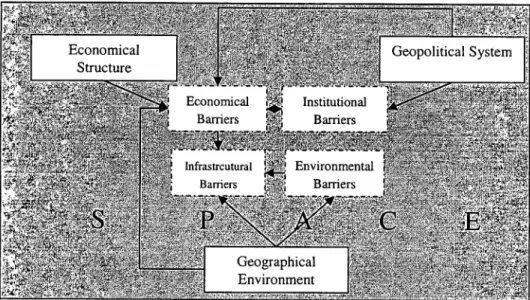
Figure 2. Spatially-materialized socioeconomic features in the geography Source: Redrawnfrom Komornicki, 2002, p.5.
Figure 2 shows the spatial framework utilized in this study. Economical,
geopolitical and geographic characteristics of states forming the EU create
of
Spatial
184 _Ankara Üniversitesi SBF Dergisi _ 61-2infrastructural, environmental and even psychological to further cohesion.
Whether it is an institution or economic activity, every human activity has to be organized in space. Hence, each social, economical, political and institutional
barrier has a spatial dimension that needs reconfiguration in the face of new
changes brought by the EU' s integration. On the other hand, the location of specific activities over the space creates a need for interaction of similar and
different activities and thus infrastructure, communication and transport
networks.
This discussion reveals that the economical, political and social
integration has to be considered together with their spatial dimension. Spatial integration may be defined as the reduction of distance between regions or
geographical areas with respect to time, monetary costs and psychological
distances. Spatial integration may be achieved through establishment of dens
transport and communication networks that increase fast movements of people,
delivery of goods and dissemination of information. in other words, spatial
integration means "to make borders as penetrable and 'spiritualised' as
possible. It also implies creating transnational cooperation networks between cities, regions and the other actors of spatial development" (ESPON, 2002, 49).
Thus, infrastructure such as transportation and ITT can play a major role in
overcoming physical distance as well as spatially-materialized socioeconomic
constraints by allowing institutions and individuals to interact more easily and even en abIing them to replace physical movement with electronic transmission.
3.
EU
and
Turkey's
Policies
Development and ITT Compared
The EU' s enlargement process accompanied by economic and political integration had dramatic impacts on the European spatial developnııent policies and will continue to challenge planners throughout Europe. A ware of this fact, spatial planning activities at the European, transnational and cross-border levels have gained a momentum in recent years, while raising questions about the role and authority of the Union with respect to planning (METCALFE, 2001: 139).
The EU aıready has a large territory covering 25 states. This territory will perhaps increase further in the future with new members envisioned to join to the EU short after 2004. With these new members, 490 million people will be
living on a 4, 300, 000 km2 (ESPON, 2004). Three factors seem to influence
long-term spatial development trends in the EU: (1) "the progressive economic integration and related increase in co-operation between the Member States", (2) "the growing importance of local and regional communities and their role in
Mehmet C. Man" e Spatial Development andınPolicies as Cohesion Means in the EU and Turkey e185
spatial development", and (3) "the anticipated enlargement of the EV and the
development of closer relations with its neighbors" (CSD, 1999: 7).
An extensive debate exists on the final destination of European spatial
integration (for example, see CAPORASO, 1996 and WAEVER, 1997) and
mostly seems to be state-centric (ZIELONKA, 2001:507). Zıelonka (2001:507) argues that contrary to a Westphalian (federal) state with a central govemment
in charge of a well-defined geography and clear-cut borders, the the EV is
destined to faH in accomplishing an overIap between its functional and
geographic borders, as long as the huge degree of divergence that result from further enlargement remain an issue. While this argument carries some merits, it also seems to ignore impacts of the new ITT on spatial organization of human
activities and the nature of capital accumulation that inevitably results in
uneven spatial development. Indeed, theEV has just recently begun to develop
spatial development and
ın
policies to overcome these spatial constıraints. But,their success remains to be seen and perhaps at large extend will require more radical measures than those adopted by the EU.
3.1. EU's Spatial Development and ITT Policies:
toward Spatial Integration
An EV' s common approach to spatial policy has emerged as a result of a
concerted attempt to impose some vision and coordination across adiverse set
of policies, regulations and other instruments applied to economic and social objectives of the union. in the past, the EV has overIooked spatial impacts of many of these policies and programs during the implementation and evaluation
face (RICHARDSON/JENSEN, 1994: 503). However, the EV's concem with
spatial development has increased in the last two decades, since many policies become concrete on the space. Thus, there was a need for protecting the space
with respect to the EV's common principles (GEDIKLI, 2002: 3). The EV's
spatial planning efforts are quite old and go back to 1945 (METCALFE, 2001:
139) (see METCALFE, 2001; üNSAL, 2001; ORALıECEMIŞ, 2001;
KESKINOK, 2001). Spatial planning may be defined as the methods that public
sector utilizes to influence the future distribution of activities in the space.
Thus, the purpose of spatial planning is to create a more rational territorial organization of land uses and linkages that connect these land uses in order to
balance economic development with a desire of protected environment, and to
achieve specific social and economic objectives. Spatial planning has a wide range of measures to coordinate spatial impacts of different economic sectors
and to succeed in distribution of economic activities between regions that
186e Ankara Üniversitesi SBF Dergisi e 61-2
The efforts of DGXVI and the Infra-National Committee of Spatial
Development (CSD) during 1990s led the EU to progress a series of initiative s on spatial cooperation in Europe. The major deve10pments in the areas of the European spatial policies have been the explorations of European spatial trend s and concepts in Europe 2000 (CEC, 1991) and Europe 2000+ (CEC, 1994) as well as the Compendium of studies analyzing the spatial planning systems and policies in the member states (CEC, 1997). These documents explicitly provide clues "of an intertextual connection of plans and visions for the EU, which are
all part of the discoursive construction of a new spatial policyand planning
field" (Richardson and Jensen, 2000: 504).
This paper will only focus on the activities of the European Conference of Ministers Responsible for Regional Planning (CEMA T)2 and the European Commission's European Spatial Development Perspective (ESDP)3 that so far covers most objectives and content of the EU' s spatial development efforts. The . paper will first summarize objectives in the EU's spatial development efforts in
light of the framework provided above and then go on to critically discuss their practical implications for the integration.
The spatial planning activities of European Conference of Ministers
Responsible for Regional Planning (CEMAT) began in 1970 in Bon. Since
then, the EU has adopted various fundamental documents that are specifically
related to spatial development issues. Between 1983 and 2002, the CEMA T
carried out the following activities:
e The European Regionall Spatial PlanningCharter, which was adopted
in 1983 at the 6th Session of CEMAT in Torremolinos. Tms charter
was later incorporated into Recommendations (84) 2 of the Committee
of Ministers to member states on the European Regionall Spatial
Planning Charter
• The European Regional Planning Strategy presented at the 8th session
of CEMAT in Lausanne in 1988,
2 CEM AT (European Conference of Ministers Responsible for Regional Planning), The
Guiding Principles for Sustaindble Spatial Development of the European Continent,
Council of Europe, Hanover 7-8 September 2000.
3 CSD (Commission on Spatial Development), European Spatial Development Perspective - Towards Balanced and Sustainable Development of the Territory of the EV, the Informal Meeting of Ministers Responsible for Spatial Plann[ng of the Member States of the European Union, European Commission, Office for Official Publications of the European Communities, Luxembourg, Potsdam May ıo/11 1999.
Mehmet C. Marın e Spatial Development andınPolicies as Cohesion Means in the EU and Turkey e 187
e The Guiding Principles for Sustainable Spatial Development of the
European Continent, adopted at i2th Session of the CEMAT held in
Hanover in 2000 and incorporated into Recommendations (2002) 1 by
the Committee of Ministers to Member States on the Guiding
Principles for Sustainable Spatial Development of the European
Continent.
The ESDP definitely represents the latest development in a decade-Iong effort to shape the EU's spatial planning policy. The process has been a durable
commitment of large amounts of human resources that has only produced a
non-binding document (JENSEN et aL., 1996: 16). While this document can be viewed as a tentative step toward the development of the EU' spatial planning policy, as Rıchardson and Jensen (2000: 503) argue, the eventual success of the
ESDP will much be dependent on its effective implementation across regions
and member states. On the other hand, the ESDP remains at large extent an
intergovernmental rather than a European document (FALVDI, 2001).
The European Spatial Development Perspective (ESDP) was a French
and Dutch collaborative initiative to add a spatial dimension to the EU's
regional policy. The ESDP has gradually evolved from informal meetings of the EU' s member states and their own spatial planning experiences. Therefore, it bears traditions and aspirations of the member states, especially those of the Netherlands, the Federal Republic of Germany and United Kingdom (EC, 1997; FALVDI, 2001). At Postdam in Germany in May 1999, the planning ministers of the EU' s member states adopted the final version of the ESDP. This success
can be contributed to efforts of both Member States and the European
commission that has been interacting and dealing with spatial issues of the
union over the past ten years (FALVDI, 2001). Many similat issues in the
member states and attempts to address them have directly or indirectly
contributed to the development of a European-wide spatial perspective. This
perspective somehow views space as a common basis on which adiverse set of
policies with territorial impacts have to build and as an instrument to coordinate and harmonize all development efforts. Af ter all once modified, this space can gradually become an obstade for further development. Therefore, the planned common space would need to meet to the future challenges of the neo-liberal economic order.
Both the ESDP and the Hanover Document, the Guiding Principles for Sustainable Spatial Development of the European Continent (GPFSSDEC), rely
on the same ideological world view and assumptions, and therefore present
similar spatial development objectives for the EU. This is not an accident,
however, considering that the principles of the ESDP nicely suit inside the
188e Ankara Üniversitesi SBF Dergisie61.2
GPFSSDEC is that it attempts to address spatial development issues and
policies of the entire Europe through some broad guidelines (CEMAT, 2000).
Furthermore, the contents of the ESDP and GPFSSDEC seem to be worded
differendy (see Appendix A) at first sight, but a closer inspection reveals that they mean the same things. Both documents can best be described as a
neo-liberal-conservative political outward perspective in terms of spatial
organization they sought out, perhaps reflecting to elite circle actively involved in their preparation. The ESDP was a product of a closed process accessible only by a national spatial planning elite (CSD, 1999), whereas the Hanover document was produced by a committee of the ministers representing member states and thus at large extent dominated by their political views (CEMAT,
2000). Hence, in both documents, a tension between the conservative world
vİew that does not seek for radical changes in the reorganization of the
European space and the neo-liberal view obsessed with strengthening
competitiveness of the European economic space gets an immediate attention.
This tension between preservation of the European space with all cultural,
ecological and economic treats as they exist and its reconfiguration for
adjustment to the new global spatial economic realities frequendy arise
throughout both documents, even in sections discussing policy objectives of protecting ecological and cultural diversity in the European regions. The ESDP
perceives "Natural and Cultural Heritage as a Development Asset" in
discussing policy objectives of the "Wise Management of the Natural and
Cultural Heritage". It states that "the natural and cultural heritage are economic factors which are becoming increasingly important for regional development" (CSD, 1999: 30). Similarly, the GPFSSDEC, on the one hand, attempts to preserve the cultural and ecological diversity of the Europe through some
guiding principles; on the other hand, it views them as assets to increase
attractiveness of European regions for investors and thus to foster economic
development (CEMAT, 2000: 11-12).
The assumptions both documents rely on spring from the well-known neo-liberal theory. in summary, it says that the special income and development gaps tends to decline in the long term, as the capital searches for higher profits and labor for higher wages through movement, ultimately leading to a spatial
equi1ibrium in which regional development difference are minimized. This
argument, however, runs into some problems as the precedent discussion
showed. First, capital İs relatively more mobile compared to the labor for
socio-psychological and political reasons. Cultural and language differences also are
likely to remain a barrier to the free movement of the labor. Second, the
envisioned European space in the both documents seems to reinforce the
Mehmet C. Mann o Spatial Development andınPolicies as Cohesion Means in the EU and Turkey o189
discussed below. Third, the logic of the capitalist accumulation and
accompanying corporate spatial strategy pursued to reduce the labor power
ultimately require spatial development gaps. in a sense, the capitali:st mode of production and its current version of the flexible production system require and
lead to spatial development differentiations to exist. These factors operate
together to create class conflict and spatial injustices. in summary, the major
concem in the both documents is the strengthening of the EU' s economic
power by reorganization of space in a way assumed to contribute to social and
economic cohesion and thus the European integration. There is also a concem
to enhance the position of the EU' s region s in world markets that have
increasingly become more competitive.
The perception of the spatial planning throughout the ESDP and Hanover
Document bears also a conservative ideological overtone. This is perhaps
expressed best in frequent statements related to anti-immigration, preservation
of existing urban hierarchy that has provided the European core regions with disproportional advantages over the past, concem on protection of transfrontier
borders, establishments of some second class "gateway cities in peripheral
regions", and economic-centric view of the natural conservation. If any thing
these spatial policy objectives may do in the case of their implementation, it is
going to reinforce existing West-oriented spatial patterns established during hay
days of nation-states. There is almost no discussion in these documents for a
European-wide vision of spatial planning that relies upon utopian concepts and
radical transformation of the space. Hence, most of the objectives explicitly
remain si1ent on ethical issues such as relations of the temtorial capital
accumulation with spatial justice, equality and class conflict. The present
spatial economic outcomes that are also likely to reinforce strengths of the
aıready weıı developed regions in the future can partiaııy be contributed to
spatiaııy-biased previous technological distribution. The establishments of the
second class "gateway cities" may perhaps strength urban relatiofis of these
centers with the urban hierarchical system within Europe. But, it mayaıso
weaken their relations with their hinterlands and internal regions.
Indeed, the emerging new international division of the labor is
characterized by capital- technology/ information- intensiye advanced core
regions and labor -intensiye industrial peripheries made up by less developed regions. in this new world, economİc disparities increase not only between the dominant and exploited classes, but also between genders and between different ethnic group s within a country or region (DUPUY, 1998). Uneven development causes population movements between the advanced zones and raw -resource zone of production at regional and global scale, depressing wages, weakening
190e Ankara Üniversitesi SBF Dergisi e 61-2
networks of economic production are interdependent poles in the new spatial mosaie of global production. Within this context, globalization and corporations do not universally influence all places equally, but rather systematically search for the synthesis of cultural diversity corresponding to differentiated regional innovation logies and capabilities (GORDON, 1994: 46).
The EU' s reliance on aıready known planning concepts such as
"polycentric spatial development", "partnership between urban and rural areas", "partnership with private sector in spatial planning", and "citizen partieipation"
is not going to make a significant change in well establishecl regional
differences. Considering the ESDP is only a perspective for the EU' s spatial
activities, and like Hanover Document does not legally bind any member state, this argument bears merits.
Several major common policy objectives can easily be extracted from the
two documents. Table 1 show s these common spatial policy objectives. As
Table 1 show s the space is given a key role in harmonization of di verse
socioeconomic policies and achieving European integration. Besides, the
ESDP deterrnines several programs that form the basis for the EU' s actions
with spatial development implications. These are Community Competition
Policy, Trans-European Network (TEN), Structural Funds, Common
Agrieultural Policy (CAP), Environmental Policy, Research, Technologyand
Development (RTD), and Loan Activities of the European Investment Bank
(CSD, 1999: 13).
• Space as a new dimension in EU' s policies plays an important role in
social and economic integration, conservation and management of
natural resources and cultural heritage, and more balanced
competitiveness of the European territory
• Strengthening of European space competitiveness
• Promoting territorial cohesion through a more balanced social and
economic development of regions and improved competitiveness
• Development of a polycentrie European settlement structure and
Eurocorridors
• Promoting more balance accessibility and developing access to
information and knowledge
• Principles of subsidiarity and reciprocity in preservation of unity İn
Mehmet C. Mann e Spatlal Development andınPolicies as Cohesion Means in the EU and Turkey e 191
• Sustainable and regionally balanced spatial development to preserve
ecological and cultural diversity
• Voluntary rural, urban, regional and transnational cooperation
• Close cooperation between spatial planning and seetoral policies
• Intercontinental and inter-trading economic blocks relationships as
strategic elements for European spatial development policy
• Euro region or exchange corridors as appropriate scale for action
• Enhancing regional identity and diversity that act as powerful factors
in social cohesion and regional development
Source: Extractedfrom CEMAT, 2000 and CSD, 1999.
The development of a balanced polycentric city system and new
urban-rural relationship are the core concept in the ESDP (CSD, 1999) and
GPFSSDEC (CEMAT, 2000), making up the basis on which other polieies with territorial impacts rely to successfully create an ultimate competitive European
space. The concept of polycentric spatial development is dynamie in that it
regards eities not only as supply centers and settlement struetures, but also
driving forces behind the development and functional networks that activate
regional resourees (ESPON, 2002: 3). The strengthening of the access through
establishment of a pan-European transport infrastrueture connecting all cities
and ITT policies that also support improvement of the European work force complete the objective of polycentric spatial development. On the other hand, Cappelin (1991: 237) argues that the dynamics of globalization tends to reduee the relative importance of the urban relations with their hinterlands or regions by enabling cities to act as independent economic agents, leading to increasing economic disparities between the urban poles and respectiye hinterlands.
The city system the EU attempt to realize, however, is not newand can
be traced back to Central Place Theory (CHRISTALLER, 1933). Similarly, the
ESDP promotes development of metropolitan regions at European level as
global integration zones, enforces a polycentric system of metropolitan regions, city dusters and urban networks at transnational level, and encourages system
of cities including the corresponding rural areas and towns at national level
(ESPON, 2002).
To realize a balanced polycentric spatial structure, the ESDP (CSD,
192.Ankara Üniversitesi SBF Dergisi. 61.2
• By using transnational spatial development strategies, the strengthening
of several larger zones including, their peripheries, that enable the EV to integrate with world markets and to function as the producers of high-quality global services,
• Development of a more balanced polycentric system formed by
metropolitan regions, city clusters and city networks and linked through a close cooperation between the Trans-European Networks (TENs) and structural policies.
• The polycentric city system also necessitates securing access to
infrastructure and knowledge through improvement of the links
between international, national, regional, and local transportation
networks.
• Promoting integrated spatial development strategies for city clusters
together with their rural areas in member states within the framework of transnational and cross-border co-operation,
• Enhancing cooperation on specific subjects through spatial
development policies that involves in cross-border and transnational
networks.
• Promoting cooperation at regional, cross-border and transnational level;
with towns and cities in the countries of Northern, Central and Eastem Europe and the Mediterranean region; Enhancing North-South links in Central and Eastem Europe and West-East links in Northern Europe (TREANOR,2004).
The ESDP (CSD, 1999) clearly distinguishes metropolitan s in the
"Pentagon" defined by a core area including such cities as London, Paris Milan, Munich, and Hamburg, from those in peripheral regions of less developed Europe. It proposes the establishment of the several pseudo- core metropolitan
regions in peripheral areas in order for the development of a balanced
polycentric urban structure throughout Europe. These cores are assumed to
function as growth pools attracting economic activities and thus reducing gaps
in economic development between the core and peripheral regions. The
GPFSSDEC (CEMAT, 2000) similarly advocates the development of a
polycentric urban settlement structure and pseudo-peripheral cores, though with
a different strategy. It proposes establishment of "gateway cities in the
European periphery", high-order cities with links to the network of other
established cities. Accordingly, the network of gateway cities will assume the
role of reducing socioeconomic gaps that the presently divides the European
continent into a core and periphery. The development of several growth pools across the continent is expected to help in preventing some isolated urban or
Mehmet C. Mann e Spatial Developmen! andınPolicies as Cohesion Means in the EU and Turkey e193
regional centers to emerge, attracting most of the investment, causing to serious
environmental and socioeconomic problems, and creating tensions and
destabilizing democracy within ED.
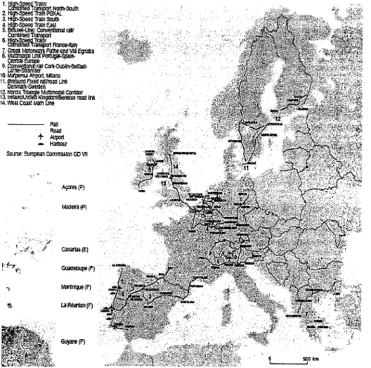
1.~~~~lnırt~5olIIIı 2. Hlglrt-Speell~P5XAI. J. Illg/)-SpeellTrilnsoııtıı J.III L-S s-
6-1. P lLILdvıaEgnaIIa
6. PllIlUÇIiI-Spölr.-9. C«k.OUt4~ lG. • MlanD 11.l1iJeJnll f1x~ rıı!foadUnt.
lle1Uı'a1lI..s,.,'EdEn
ıı.~=TıtaıllloMu_J_
13.1",1aIIci\:Jnnl'llKI~1IX raad Il'a
14. Wesl C'OJ#. loIain One
Raıı
RDGd
+PIr,ıOrt HiIJllat,T
Saj:te: Europea!! Camıııwon GO VII
AÇılrCi (P}
Figure 3. The balaneed polyeentrie spatial development o/ urban strueture shown by A and the map 0/14 priority projeets o/Trans-European Transport Network shown by B
Souree: CSD, 1999, p. 15,26
The improvement of transport, information and telecommunication
infrastructure is a vİtal component of the balanced polycentric spatial
194 _Ankara Üniversitesi SBF Dergisi _ 61.2
different scales together to support the flows of goods, services, people and
information throughout the system (CSD, 1999; CEMAT, 2000) Naturally,
these two, land use and transport-ITT infrastructure, have to be considered
together, as each affect the other, or vice versa (BOARNET/MEDDA, 2003).
Thus, there is a good reason why the EU emphasizes so much on tramsport and ITT policies in the both documents, as the following short literature review will show.
The EU has increased financial resources dedicated to regional RTD
(Research, Technologyand Development) from 2 billons EUR in 1989-1993 to
5 billion EUR during the period between 1994 and 1999. Yet, the technology
disparities across European space continued to remain an obstacle when
compared to cohesion gap. Between 1994 and 1999, while technology gap
measured as GERD/ GDP was about 5:1, the cohesion gap between the poorest and richest member state was less than 2:1 (GUTH, 2000:1-2).
The improvements in transport and ITT have enabled econornic activities and other forms of the human organization to find new ways of overcorning spatial constraints (BOZKURT, 2000: 94-95). First, as these new technologies have rapidly improved, there has been a paralle! dramatic decline in spatial interaction costs that have so long put constraints on the spatial organization of production process and location decisions. Today, these technologies provide
firıns with many alternatives for the spatial organization, ranging from
separation and relocation of activities in different geographic settings,
establishments of networking firms, to virtual enterprises formed by a leading
firm that coordinate and control production and marketing and some other firms
with different functions (MARIN, 2004: 253; MARIN, 2004: 2003: 736).
Secondly, because the current global economy relies on information
technologies, increase in the productivity results from processing, maınagement
and application of information to production and distribution of goods and
services rather than increase in conventional production factors such as labor,
capital and land (BORJA/CASTELLS, 1997: 7). Thus, ITT enabled firms to
reduce business costs, while increasing productivity at the same time. The
collection, storage and process of the information is not also solely unique to
information-intensive production processes, it has spread across all econornic
activities in our time (MOSS, 1999). Hence, the production and strategic
process of the information plays a major role in productivity and
competitiveness of firms functioning in the contemporary global world markets. This in return led to transport and ITT along with human capital to increasingly become more important in regional and urban econornic development policies
(BORJA/CASTELLS, 1997: 7-8). Information and telecommunication
Mehmet C. Mann e Spatial Development andınPolicies as Cohesion Means in the EU and Turkey e195
geopolitical borders of the nation-states to insignificance, while increasing the
volume and speed of interactions at local and global levels. These changes
brought cities and regional govemments to forefront as unit of economic
activities and active agents in regional economic development policies.
One of the well-known arguments in the economic geography is that the
networks that link activities of various firms in different sectors creates
innovation and enhances productivity. Rapid and dramatic changes in world
markets and decreases in innovation period s have given a rise to the
significance of collective efforts of firms in different sectors, research and
social institutions, making them the real engine behind current technological
improvements and economic development (LAPPLE, 2001; CAMAGNI,
1991). So, the effective utilization of ITT by most economic activities is still
dependent on specific places where the se technologies and institutions
adequately present (GALLIANAOIROUX, 2001: 2).
The most important objective of the European integration was and still is economic and social cohesion. The Single Act in 1986 further defined this objective and delegated political responsibility for an enhanced economic and social cohesion to the ED. This objective was going to be realized through
reduction of income and development gaps between the regions, since the
European history has repeatedly shown that large income disparities coincided with political conflict and radicalism. The Single Act also allowed the Union to formuiate some policy tools that would ensure economic and social coherence: (1) coordination of policies in member states, (2) the Single Market Program, (3) the European Structural Funds, (4) the European Investment Bank (EIB) and (5) other financial instruments (GUTH, 2000: 2). Spatial development and
ITT policies are more recent aUempts to bring the spatial dimension as a
caordinating and harmonizing factor to implementation of all other policies.
The spatial policies are aimed at promoting social cohesion and furtber
integration through a more balanced territorial development characterized by a
polycentric seulement structure that links cities, regions, and corresponding
rural hinterlands across the EU, regardless of geopolitical barriers, to form an active network. Investment in transport and ITT infrastructure that connects the entire European space and performs similar functions as blood vessels in human
body is assumed to increase the access of seulements to rnarkets and
knowledge, thereby creating both an environment conducive to innovation and competitive economic space aUractive to foreign investment.
According to the GPFSSDEC, a coherent strategy "for integrated and
regionally balanced development of our continent (Europe)" should be based on principles of "subsidiarity" and "reciprocity", "strengthens competitiveness" in
196e Ankara Üniversitesi SBF Dergisi e 61.2
regional authorities across borders. Hence, the implementation of Guiding
Principles requires a elose cooperation between spatial planning and sectoral policies that can affect spatial structure through their measures. This is expected to contdbute to the democratic stability of Europe. GPFSSDEC also caIls for
cooperation of states on Black See and Euro-Mediterranean regions in their
future spatial development policies in light of Guiding Principles. The
GPFSSDEC is well aware of the role transport and telecommunication
infrastructure can play in spatial integration by emphasizing "the speedy
development and implementation of pan-European Transport Network
(especiaIly the 10 Pan-European Transport Corridors)" that will increase the
accessibility of large areas across the whole continent (CEMAT, 2000).
The EU' s spatial development and ITT policies are likely to reinforce the historicaIly dominant roles of regions, especiaIly the Pentagon ıruıde up by
urbanized areas of information-intensive economy, in the future. The European
urban hierarchical structure may increasingly integrate
3.2. Turkish Spatial Development and ITT Policies
Unlike the EU, Turkey has not so far developed a national spatial
development and ITT policies, even though State Planning Ageney (DPT) has
over time adopted some relevant policy guidelines. Furthermore, presently a
diverse set of law s give responsibility and authority to several ministers,
municipalities, and metropolitan municipalities to implement various policies
with territorial impacts, while ignoring functional and spatial relationships that arise among different settlement structures across the whole country. Instead, it seems that the major efforts, albeit not directly relevant as in the EU' s policies,
in the spatial development in Turkey have mainly been concentrated on the
three basic issues: urban conglomerations of various smaIl and large cities that
attract rural migrants and thus create socioeconomic problems, regional
socioeconomic gaps that divide the country into a rich core and huge periphery,
and socioeconomic development of rural areas and prevention of rural
migration. To address the first issue, Turkey has adopted municipal and
metropolitan municipality laws to determine administrative boundaries,
responsibility, authority and political statues of metropolitan and encompassed
smaIler district municipalities. The basic purpose in these law s is to reduce
conflict and address coordination problems through elearly defined
responsibilities and authority of each municipal body in socioeconomic and
political areas, ineluding land use and transportation planning, taxing, legal
Mehmet C. Mann e Spatial Development and ITT Policies as Cohesion Means in the EU and Turkey e 191
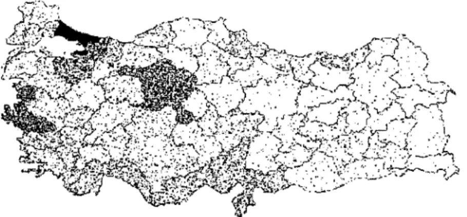
Studies on regional development in Turkey demonstrate a large income gap between regions. Indeed, between 1983 and 1998, the average per capita GNP index ranged from 156 in Marmara to 41 in Eastem Anatolian Region
(DPT, 2000: 70). Historical factors, national policies, market size and
distribution of the basic infrastructure have all contributed to geographical
distribution of industry and corresponding spatial income gap s in Turkey.
Today, regions of Marmara and Aegean as well as some cities in Central
Anatolia and Mediterranean regions house most of the industriallProduction
(see figure 4). This regional development differences elearly indicates large income and indusial production gaps, leading to a rich core area centered in the westem and a poor periphery covering especially eastem and northem parts of
the country (TEKELi, 1984; ERKUT/BAYPINAR, 2003). The persistence of
this spatial dualism between the West and East has long characterized the
spatial development and continues to rise (GEZICIIHEWINGS, 2003: 2). The
progress report of the Council of Europe in 1999 directs attentions to serious
regional income gaps in Turkeyand the country's relatively low per capita
GNP in comparison to that of the union (AKTT, 1999: 84-85). The
commission's report in 2000 (AKTT, 2000: 72-73) points to the need for
development of an effective regional policyand accompanying institutional
changes aimed at reduction of regional income disparities, as Turkey prepares for membership. The report proposes an immediate attention to be given to the following areas:
Figure 4. The geographical distribution ofindustrialftrrns in Turkey Source: Erkut and Baypınar, 2003, p. 17.
• The present regional policies should be implemented with all structural
198e Ankara Üniversitesi SBF Dergisi e 61.2
e There is need for development of NUTS, regional statistical' areas,
where structural regional policies carried out in line with the union rules4;
e Analysis of public İnvestment does not indicate an effort for
improvement of the poor regions;
e Most regional and rural development projects of the State Central
Planning Ageney (SCPA)' s have not been implemented;
e The SCP A should be organized at regional and national level.
To address the regional development and income disparities, the state
has over time developed various policies aimed at improvement of
socioeconomic conditions of the poor regions through place-specific large state projects and a set of fiscal and economic incentives for the companies locating in the cities within geographic boundaries of the poor regions. Thus, the second group policies may broadly be classified into two subgroups. The first group
policies invol ve in publicly financed-Iarge state projects as in Southeastem
Anatolian Project (GAP) or Eastem Anatolian Project (DAP). These projects utilize indigenous regional resources to improve socioeconomic comditions of the citizens. Furthermore, the se policies are much broader in their contents, for
they attempt to bring sectoral, social, land use and transportation policies as
well as institutions and local citizen to activate regional resources
(MARIN/ALTINTAŞ, 2003) The policies making up the second subgroup are
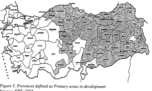
relatively narrower in their scope and urban-specific in that they define regions based on GNP and similar socioeconomic indicators as developing, primary,
and secondary development areas where firms were given some fiscal and
economic incentives to operate (see Figure 5 for provinces that are defined as primary areas in development). As Erkut et al (2001: 117) point out, there have
been several attempts of Turkish regional development initiative in Turkey
since 1950, but these were more formalized and carried out after 1963 through
Five Y~r-National Development Plans and activities of various ministers.
4 Turkey deveIoped the CIassification of Statistical Regional Unites (CSRU) on 22 September 2002 to meet an important requirement of the Union. The CSRU is expected to heIp in analysis of regionaI socioeconomic conditions, development of effective regional policies, and comparisons with statistics of the EU (for more details
see the official web side of State Central Planning Ageney (DPT) at
Mehmet C. Mann e Spatial Development andınPolicies as Cohesion Means in the EU and Turkey e199
Figure 5. Provinces defined as Primary areas in development Source: DPT, 2004.
Finally, the third group policies have historically evolvecl from the
needs of the new republic to improve rural areas through the ir sodoeconomic
transformation (GERAY, 1999: 12). Since the foundation of the Republic of
Turkey, urbanization of the large rural areas to build a Westem type
industrialized society with modem values was a major concem among the
polito-bureaucratic-army elite (GEDİKLİ, 2002: 11). Intellectuals, political
parties and state officers have developed concepts and utopian plans to address various problems associated with barriers confronting the rural development. Cities were viewed as active agents in the transformation of the society through
their role in dissemination of republican ideologyamong the largest segment of
citizens. Therefore, the state felt an urgent need to build small towns across large rural parts of the country in order to rapidly transform the traditional
society into a modem one. These plans simply failed due to ignorance of
feasibility studies and spatial relations, and unfamiliarity with socioeconomic
conditions in the rural areas. Today, projects such as village tovm, central
village or agro-town still remain at large extent an ideal in many minds for rural development.
Turkey has lifted restrictions on its economy since 1980s through
liberal policies of its trade regime, currency and movement of foreigN capital in order to better integrate with world economy and the EU as well as to attract foreign investment. But, these changes have also affected spatial organization and spatial income disparities through the industrial growth and their location
200. Ankara Üniversitesi SBF Dergisi. 61-2
economic policies of many nations including Turkeyand the beginning of the
financial dependency of cities around the world, as public spending and
resources were cut back. The shortage of financial resources challenged many cities to find new ways of getting resources, mostly by policies that give some
advantages to foreign and domestic firms for relocation. Thus, urban and
regions have increasingly become entangled within network of the global
economic relations as influential players in regional economic development, as
the world economy and accompanying relations continues to relate and
integrate human activities across the continents. As Tekeli (2001: 31-33) points out, perceived as a project of modernization in Turkey, urban and regional
planning lost its significance in shaping post-1980 urban structures. Unlike
cities in developed countries where overaccumulation of the surplus in the first circuit of the capital was channeled into the less profitable investmelilt in urban
infrastructure and services during 1960s, allowed the implementation of state
welfare programs and allocation of resources for social consumption in those cities. By contrast, in Turkey, the economic system could not acmeve this level of the capital accumulation and hence was unable to channel money into the built environmenl. Combined with the lack of state and municipalities resources to improve urban infrastructure and meet needs of increasing number of rural to urban migrants, these economic conditions have led to devastating impacts
on Turkish cities (ŞENGüL, 2001: 186-188). According to Ünsal (2001: 148),
the vacuum created by the decline of urban and regional planning from the scene and unwillingness of the central governmental institutions such as Central Planning Ageney to actively involve in planning after 1980s was fiUed out by citizen and other democratic institutions in Western Europe, whereas in Turkey by an informal structure made up by a rent -seeking coalition of interest groups,
politicians and bureaucrats. Indeed, arecent report by a commission of the
Turkish Grand National Assembly points to efforts of these informal coalitions
in the development of squatter settlements in major metropolitan areas
(ŞENER, 2003).
Current world economy has been reshaped by multinational economic
blocks, advancement in technologies that enable rapid exchange of information,
the liberalization of trade and capital flow (GEDİKLİ, 2002: 5). To Ünsal
(2001: 148), accession to the EU and import of neo-liberal ideology may
ultimate1y multiply problems associated with urban development in Turkey. It
has been suggested that there is a need to create a strong image of our cities
within urban system and build their competitive capabilities (KEYDER/
ÖNCÜ, 1994; quoted from ŞENGüL, 2001: 158). Accordingly, the EU's
accession processes requires changes at urban and regional levels, as it forces us to consider new models of economic developments that operate at regional
Mehmet C. Marın e Spatial Development andınPolicies as Cohesion Means in the EU and Turkey e 201
economy. This is a realistic scheme based on the fact that the present global
economic world order continues to value and devalue every place in the
network of exchanges. As Şengül (2001: 160-163) argues, this solution ignores the deep social meaning attached to the space and spatial justice that may arise within a country.
Spatial planning is an effort to locate and direct the distribution of
various aıctivities in space in a way that will harmonize the future
socioeconomic development with natural and human-made environment. As
exemplified by the ESDP, spatial planning has to be a means in all spatial
development efforts. The State Central Planning Agency (DPT) develops and carries out regional development policies in Turkey through plan ts for every five year. in 1980, DPT collected data for the first time to determine the spatial structure of Turkey. Using this data set, Mutlu (1988) conducted a serious study of the Turkish urban spatial hierarchy.5 On the other hand, the National Five
Year Development Plans have generally been silent on the spatial issues,
ignoring the close relations between socioeconomical policies and spatial
development.
in this paper, the last National Five Year Development Plan, the 8th State
Five Year Development Plan, will be the focus in comparing Turkish spatial
development and ITT policies to those of the EU. The plan points to the need to
reduce regional income disparities prominent in the East and Southeastem
Anatolian regions through activation of local resources and support of smaIl business with financial resources. There is not a mention of the space, but an
emphasis on the sustainable development among the principles, goals, and
policies of the regional development. It also directs the attention to the need for classification of setdements areas to make the implementation, determination of goals, and coordination of economic decisions of regional development policies easier (DPT, 2000: 71-73).
Although theyonly remain as good concepts at large extent in the 8th
Plan, since all Five Year National Development Plans do not bind private
enterprises but only those of public sector, there are some spatial development
and ITT related objectives. Containing long-term development straıtegies that
cover a 22-year period, the 8th Plan mentions the following ITT and spatial
development related objectives:
• transforming the country into an informational society;
5 For more details of Turkish spatial urblan hierarehy and its determinants see Servet Mutlu, The Spatian Urban Hierarehy in Turkey: its Stmeture and Some of its Determinants, Growth and Change, Volume 19, No 3,1998, p. 53-74.