Contents lists available atScienceDirect
Geothermics
journal homepage:www.elsevier.com/locate/geothermics
Hydrogeochemical similarities and di
fferences between high temperature
geothermal systems with similar geologic settings in the Büyük Menderes
and Gediz Grabens of Turkey
Füsun S. Tut Hakl
ıdır
a,⁎, Raziye
Şengün
baIstanbul Bilgi University, Department of Energy Systems Engineering, Eyüp Istanbul, Turkey bZorlu Energy, Denizli, Turkey
A R T I C L E I N F O Keywords:
Western anatolia Büyük Menderes Graben Gediz Graben Geothermal systems Hydro-geochemistry Stable isotopes Non-condensable gases Sulfur A B S T R A C T
The Büyük Menderes Graben (BMG) and the Gediz Graben (GG) are two major graben systems and they have
important medium-high temperature geothermal systems, with suitable reservoir temperatures (e.g. 170–276 °C)
for electricity production such as Kızıldere (Denizli city), Germencik, Salavatlı, Pamukören (Aydın city) in the
BMG and Alaşehir (Manisa city) in the GG.
These high temperature geothermal systems are located in a highly fractured zone because of the Aegean
Extensional Zone effect. Although the main reservoir rocks retain similar compositions for each graben system,
the geothermalfluids chemistry characterization can vary along the BMG and GG as a result of differing
vari-ables such as a paleo sea effect, the concentration of non-condensable gases (NCG), as well as mineral effects.
The water chemistry results andδ18O-δD isotope values show remarkable differences within the Germencik and
Kızıldere systems along the BMG, while the main reservoir rocks are of a similar composition. Chemical, isotope
compositions and pH values of thermal waters in Alaşehir differ from those in the BMG geothermal systems.
Results forδ13C isotopes indicate that the origin of the large amounts of CO
2is the marble in metamorphic
rocks in the reservoirs in both graben systems.δ34S,δ34S- SO
4andδ18O-SO4values indicate that the origin of SO4
indicates gypsum and also bacteria effect in the eastern part of the BMG, while different mechanisms such as;
oxidation of sulfur, pH, temperature and possible buffer mineral effects on H2S dissolution to the west of the
BMG and GG display a greater impact.
1. Introduction
Turkey has a remarkable geothermal capacity evidenced in over 234 identified geothermal sites (MTA, 2018). Variable tectonic zones and the young volcanism have led to the manifestation of geothermal sys-tems comprising differing characteristics across Anatolia. The country has been strongly affected by the Alpine-Himalayan orogenic belt that is emerging at the convergence of the Eurasia and African Plates and concludes with the crustal thickening resulting from tectonic com-pression in Eastern Anatolia.
The geodynamics of Western Anatolia differ from other parts of Anatolia, illustrated by the extensional tectonics, crustal thinning and the formation of large graben systems have been formed in that part (Doglioni et al., 2002;Şengör and Yılmaz, 1981). These graben struc-tures provide optimum conditions for shallow and expansive heat sources across Western Anatolia (İlkışık, 1995). The Cenozoic
volcanism can be seen from the North to the South (Doglioni et al., 2002;Ercan, 1979;Innocenti et al., 2005) and the youngest Quaternary basalts have been observed in Kula (Manisa city) in Western Anatolia (Tokçaer et al., 2005). Resulting from this tectonic regime, medium -high temperature geothermal systems have developed in the Western Anatolia Extension (Mutlu and Gülçe, 1998). Curie point temperature-depth studies indicate that the temperature-depth of the heat source is approxi-mately seven kilometers in Western Anatolia; it reaches 30 km in Eastern Anatolia and 25 km in Central Anatolia (Aydın et al., 2005). These results look comparable to reservoir temperatures found in Western Anatolia graben systems (Koçak, 2012).
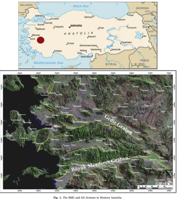
The main extensional zones are the Büyük Menderes Graben (BMG), the Gediz Graben (GG) (Fig. 1) and The Simav Graben, all demon-strating optimal geothermal potential in Western Anatolia.
The BMG, trending East-West for nearly 200 km, including the Menderes Graben, is one of the largest grabens in Turkey. There are
https://doi.org/10.1016/j.geothermics.2019.101717
Received 13 July 2018; Received in revised form 7 August 2019; Accepted 14 August 2019
⁎Corresponding author.
E-mail addresses:[email protected](F.S.T. Haklıdır),[email protected](R.Şengün).
Available online 03 September 2019
0375-6505/ © 2019 Elsevier Ltd. All rights reserved.
Fig. 1. The BMG and GG Systems in Western Anatolia.
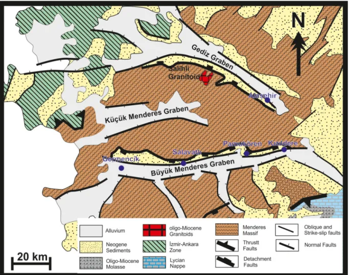
many geothermal manifestations from the west to the east (Şimşek, 2005). Along the BMG from west to east; the Germencik, Salavatlı, Pamukören, Kızıldere fields exhibit high temperature geothermal sys-tems and reservoir temperatures reaching 245 °C in Kızıldere and Ger-mencik (Haklıdır Tut and Güney, 2013;Şimşek, 2003;Fig. 2). There are a few identified low temperature geothermal systems, such as the Pa-mukkale, Gölemezli, Karahayıt fields (Şimşek et al., 2000;Tut, 2003) at the intersection of the BMG and the GG.
Although the BMG has been well explored by geoscientists since 1965, the geothermal capacity of the graben has only been understood since the mid-2000s, with a continued identification of new geothermal systems. For GG, the serious geothermal exploration-based studies for power production purposes began in Alaşehir in 2009. Since then, privatization of the geothermalfields was started by the Turkish gov-ernment and following additional geological, geophysical and geo-chemical surveys, new geothermal drilling operations have commenced along the BMG (DiPippo, 2012; Haizlip Robinson and Haklıdır Tut, 2011,2012;Haklıdır Tut et al., 2011;Kındap et al., 2010). Currently, a significant number of companies have conducted studies to establish different types of geothermal power plants along the two grabens. The high geothermal potential of the GG was realized in 2009, resulting in a few companies currently conducting power plant feasibility studies. The temperatures of water-dominated reservoirs along the graben may vary between 190–213 °C for high temperature systems such as Alaşehir Piyadeler and Kavaklı regions (Aydın et al., 2018;Haizlip et al., 2016; Bundschuh et al., 2013;Haklıdır Tut et al., 2012). Besides them, there are medium-low temperature geothermal systems such as; the Salihli, Sart, Urganlı, Kurşunlu systems whose water temperatures vary be-tween 35° to 85 °C (Bundschuh et al., 2013;özen et al., 2012;Tarcan et al., 2005;Vengosh et al., 2002) along the graben. Along the SG, reservoir temperatures can reach 162 °C (Gemici and Tarcan, 2002) and geothermal district heating applications have been established near the graben (Köse, 2007;Palabıyık and Serpen, 2008).
In this study, the reservoir characteristics of the high temperature geothermalfields along the BMG and GG (Fig. 1) are evaluated from a hydro-geochemical perspective.
2. Geothermal energy developments in the study area
Between 1984–2018 39 geothermal power plants were installed along the BMG and GG. Most of them are located at between Denizli and Aydın (Kızıldere, Pamukören, Salavatlı, Germencik geothermal systems in this study) provinces from the east to the west edge of the BMG. The Alaşehir geothermal system is a part of the GG which is one of the high temperature systems and ones of the investigated one in this study.
The first geothermal exploration studies were initiated in the Kızıldere (Denizli) geothermal field, which is located east of the BMG in 1965 by the General Directorate of Mineral Research and Exploration (MTA) (Dam and Erentöz, 1970). With thefirst drillhole in 1968, called KD-1A, with a 198 °C bottom hole temperature in Kızıldere (Denizli), which takes place in the east edge of the BMG. The geochemistry stu-dies were performed in thefield (Dominco andŞamilgil, 1970). In Kı-zıldere, a 17.2 MWegrosscapacity singleflash geothermal power plant (GPP) was established in 1984 and 25 wells were drilled until 2008 by the MTA (Şimşek et al., 2009). After the privatization of the geothermal field, more than 50 new geothermal wells drilled up to 3500 m. depth after the geological and geophysical surveys were conducted to build the Kızıldere-II GPP 80 MWegrosscapacity tripleflash + binary system in 2013 and the Kızıldere-III GPP 165 MWegrosscapacity tripleflash and binary systems in 2018 for the total power production to reach a 260 MWegrosscapacity in the Kızıldere geothermal field.
The Germencik (Aydın) geothermal field is located at the west edge of the BMG and geothermal studies started there in the 1980s (Şimşek, 1985), with the first geothermal well, ÖB-1, drilled at 1982, with a recorded temperature of 203 °C at depth in the field. After the
privatization of thefield in 2004, new wells were drilled by the com-pany, and a 47.4 MWegrossdouble-flash GPP was established and the capacity increased to 279grossMWe with a new two doubleflash plant andfive binary power plants in 2018.
Thefirst drilling operation was started in the Salavatlı (Aydın) re-gion by MTA in 1987. The reservoir temperature was measured as 167 °C in the AS-1 well (Karamanderesi and Helvacı, 2003). In 2006, with a new well, the company built afirst binary type Dora-I GPP with 8.5 MWegrossin thefield (DiPippo, 2012). In Salavatlı region 4 binary type power plants were installed between 2010–2018 period. The geothermal power capacity increased to near 56 MWe.
The Pamukören (Aydın) geothermal field was discovered by the MTA in 2008. The reservoir temperatures were recorded as 188 °C, at 1150 m. and the geothermal power capacity reached around 114 MWe in 2018.
The Alaşehir geothermal field (Kavaklıdere-Manisa) in the GG was discovered in 2009 and subsequently geothermal exploration studies and drilling operations were performed in the region (Haklıdır Tut et al., 2013). Thefirst geothermal power plant in the GG was installed as a 45 MWegrossdoubleflash + binary type and a few binary type GPPs were also put into use and the power capacity reached 198 MWe at the end of 2018. Exploration and capacity expanding studies have been continued for both graben systems (EMRA, 2019).
Today Turkey’s installed geothermal power production capacity is around 1.8 Gwe for 2019 and it has been declared by the government that the geo-power target will be 4 GWe for 2030.
3. Methodology
Within the scope of this study,five high temperature geothermal fields, which are quite important for geothermal power production, along the BMG and GG have been selected. Based on the geological and geochemical information for deep geothermal wells in selectedfields, reservoir characteristics were evaluated with a hydro-geochemical perspective. These selected wells are representative of each high tem-perature geothermal fields such as Kızıldere (wells number KD14, KD22, R1, R3A, KD18A, KD42), Germencik wells (OB8, OB9, OB14, OB17), Salavatlı wells (AS1, AS2), Pamukören wells (AP1, AP2, AP3), Alaşehir wells (Alkan1, Alkan2) in both graben systems and this will provide an opportunity to compare and understand the BMG and GG geothermal systems in Western Anatolia's similarities and differences. These wells depths vary from 603 to 3155 m in the BMG and 960–1500 m in the GG.
Except for the Kızıldere and Alaşehir geothermal fields, water and gas analysis results used in the present study were obtained from dif-ferent researchers. The chemical analysis of Kızıldere and Alaşehir water samples was carried out by the MTA laboratory in Ankara, Turkey. The following parameters; K+, Na+, Ca2+, Mg2+, Li, boron, SiO2and As were analyzed by the Inductively Coupled Plasma (ICP) method. A volumetric method was used for HCO3−analysis. Anions such as Cl−, SO42-were analyzed using ion chromatography, while a titration method was used for NH4+.
In the Kızıldere and Alaşehir geothermal fields, water and gas samples were collected from the wells selected. There are two main reservoirs in Kızıldere field and the wells selected were in shallow and deep reservoirs. The procedure is similar to sampling the water and gas phases is similar, thus, the following statements are applicable for all high temperature geothermalfields. Sampling and field measurements performed by the authors. During the sampling period, brine, gas samples were collected by a test and sampling equipment such as; a sampling separator, a cooling condenser, a pH meter, a conductivity meter and polyethylene bottles for water sampling, Giggenbach glass bottles for steam (gas) sampling. During the gas sampling, steam con-densate samples were also taken from each gas sampling period to understand sampling quality.
sampling and it is controlled by the well-head and separator pressures during the sampling period. Brine samples were collected for chemical and δ18O-δD isotope, δ13C−CO
2 and δ34S andδ34S-SO4/ δ18O-SO4 analysis with sampling separator and condenser systems. Silica samples were diluted 1/10 by distilled water and cation samples werefiltered and preserved with nitric acid. Anion and cation samples were collected into 1000 ml containers and silica samples were collected into 250 ml polyethylene bottles.
δ18O-D isotope samples were collected into 12 ml glass bottles, and δ32/34S andδ34S-SO
4/δ18O-SO4isotope samples were collected into glass bottles during the sampling period (Haklıdır and Haizlip, 2012). δ18O-D isotopes were analyzed by Thermo-finnigan MAT 253 model isotope ratio mass spectrometer at the National Metrology Institute isotope laboratory in the Scientific and Technological Research Council of Turkey (Kocaeli-Turkey).
Gas samples were collected from the steam discharge line of the sampling separator. The samples were collected by Giggenbach gas bottles, which were prepared with 40–80 ml 6 M NaOH solution, va-cuum packed and analyzed by the National Research Council (CNR-Italy) gas laboratory in Italy. In the laboratory, gas chromatography (with thermal conductivity detector-TCD) has been used for H2, N2, O2, Ar, He analysis. An acidimetric titration was used for CO2gas analysis. Ion chromatography was used after oxidation to SO4using H2O2for H2S gas analysis.δ13C-CO2analysis performed by CNR-Italy andδ34S and δ34S-SO
4 /δ18O-SO4 analysis was carried out by the Stable Isotope Laboratories in Arizona University (USA).
4. Geological settings of the geothermal systems along BMG and Gediz Graben systems
4.1. Structural controls of geothermal systems along graben systems in Western Anatolia
Tectonic structures give evidence to the existence of extensive geothermal systems and Neogene volcanism in Western Anatolia and the Aegean Sea, which is due to the westward plate motion and the expansion of the Anatolian Plate (Fig. 2).
Geothermal systems due to tectonic activity have both good re-servoir potential and fluid carrier properties. Low and medium tem-perature geothermal springs discharge along these graben systems such as; Ilıcabaşı (101 °C), Yılmazköy, (142 °C), Söke (26 °C) Aydın province; Pamukkale (36 °C), Karahayıt (59 °C), Gölemezli (101 °C) and Yenice (70 °C); Denizli province besides high temperature geothermal systems in Germencik, Salavatlı, Pamukören (Aydın) and Kızıldere (Denizli) (Şimşek, 2003). All these systems are directly affected by the Aegean extension zone. The greater the expansion rates of the BMG graben by the northern faults, which are affecting the graben asymmetrically, are generally decreasing rapidly towards deeper sloped listric normal faults. Directions of the traverses are E-W and ES E-W NW. In Kızıldere, faults of differing types and directions are observed (McKenzie, 1972; Şimşek, 1985;Seyitoğlu and Scott, 1992;Şimşek et al., 2009).
The BMG is predominantly influenced by the E-W and ES E-W NW directional listric faults by reason of the N-S directed drift. The northern faults, which are affecting the asymmetrical graben basin forms, gen-erally tend to descend deeper as normal dip-slip faults. In addition, normal faults and grabens running N-S were observed in the region. N-S tectonic movement is a dominant factor in the region, although the presence of a lower level of E-W directional stress is expected (Emre and Sözbilir, 1997; Bozkurt and Oberhänslı, 2001; Yılmaz, 2017; Çırmık and Pamukçu, 2017) (Fig. 1).
The Gediz Graben has an approximate E-W and WNW-ESE trend with 140–150 km length and 10–40 km width (Yılmaz et al., 2000; Seyitoğlu et al., 2000;Bozkurt and Sözbilir, 2004). The graben structure was described bySözbilir (2001)as four different types which are the Gediz detachment, extensional folds in the Gediz detachment, E-W to NW-SE trending high-angle normal faults and a regional unconformity
between the supra detachment sequence deformed by W-NW to N-NE high-angle normal faults.Çiftçi and Bozkurt (2009)suggested that the GG is a continental expansion basinfilled with Miocene-Present aged sediments and graben development occurred in two phases. In thefirst phase, a half graben controlled by a southern edge fault, Gediz, Alaşehir and Çaltılı Formations collapsed in this graben and in the second phase after Miocene they were relatively balanced with sedimentation and deepening together with faulting in the northern wing (Fig. 2). These intensive tectonic movements and the Salihli Granitoid provide geo-thermal reservoir possibilities at depth (Aydın et al., 2018) and they also suggest the heat source for the Alaşehir geothermal systems. 4.2. Reservoir geology characterization overview for the BMG and GG geothermal systems
The graben consists of Paleozoic aged Menderes Meramorphics and Pliocene aged sedimentary rocks, covered with a Quaternary aged al-luvium (Şimşek et al., 2009). The geological units demonstrate con-tinuity along the graben (Fig. 2) and it is also possible to observe coal levels in Miocene aged sedimentary rocks along the Büyük Menderes Graben (Kayseri özer and Emre, 2012). The oldest unit of thefield is metamorphic rocks, which are from the basal geology forms called the Menderes Massif (Okay, 1989). The metamorphics formed by gneisses, and represented by a variety of schists, quartzite, and marble. The İğ-decik Formation is recognized as a separate member of the Menderes Metamorphics due to the presence of thick marble layers and can be observed only in the Kızıldere geothermal system. The Kızılburun Formation has a dominant red color due to oxidation (iron oxide), followed by coarse basal conglomerates intercalated with sandstone, claystone and conglomerate, unconformably on the Menderes Meta-morphics. The Sazak formation contains marl, claystone and limestone, and shows a gradual transition toward the bottom with the Kızılburun Formation, and at the top with the Kolankaya Formation, which con-sists of sandstone and marl intercalation. The Tosunlar Formation has been developed by a large strike-slip fault. Consisting of speckled red, yellowish colored conglomerate, sandstone, claystone and limestone units, this formation covers the whole geological sequence with an angular unconformity (Fig. 3;Şimşek et al., 2009). In the Quaternary period, alluvium, old alluvial terraces, talus and travertine structures have formed and been deposited over the graben.
Along the graben from the west to east part; in the Germencik, Salavatlı and Pamukören geothermal systems, the main and deep re-servoir is seen to be abundantly fractured at fault levels of the Menderes Metamorphics as Paleozoic aged highly fractured rocks including quartz schist and marbles (Filiz et al., 2000; Fig. 4). The Salavatlı geothermal system is located in the middle of the BMG and the Pa-mukören geothermal system takes place lies between Salavatlı and Kı-zıldere system. The both two systems are formed in younger graben deposits beside the metamorphic rocks (Vengosh et al., 2002). During the evolution of Pamukören system, such as in thefields of Salavatlı and Germencik, a compressive tectonic is prevalent in the Pre-Miocene phase (Şimşek, 2003). The gneisses are evaluated as a good cap rock in these geothermal systems.
The Germencik geothermal system has multi-reservoirs which are not directly connected to each other, and they may be separated by different reservoir temperatures. There are two main reservoirs in Miocene sediments; fractured and consisting of sandstone. The con-glomerate is defined as the first reservoir, with a deep reservoir as the second one, represented by Menderes Metamorphics. Reservoir tem-peratures are recorded as 203–217 °C for the first reservoir and higher than 230 °C for the second reservoir (MTA, 2005;Karakuş and Şimşek, 2013). The highest temperature is recorded as 276 °C in well OB-88 in Germencik along the BMG (Şimşek, 2015). There are more than 100 wells in the Germencik geothermal system alone. The average reservoir temperature is recorded below 200 °C in the Salavatlı and Pamukören (175–185 °C) geothermal systems (Karamanderesi and Helvacı, 2003;
Serpen and Aksoy, 2010).
The Kızıldere geothermal field is an important field in the BMG for its key location at the intersection of the Büyük Menderes and Gediz grabens. The Sazak Formation, theİğdecik Formation, and the lower layers of the Menderes Metamorphics constitute the reservoir rocks and they are identified as multi-reservoir systems with different tempera-tures (Şimşek, 2003). There is no direct connection between the re-servoirs and they can be distinguished from each other by reservoir temperatures. The Sazak Formation, as the first reservoir rock, is in-tercalated with limestone and marl, which have become permeable due to tectonic moves (Şimşek, 1984;Karamanderesi and Özgüler, 1988) and uses for the limited reinjection. Theİğdecik Formation is referred to as the second reservoir which made up of metamorphics, consisting of marble, mica schist, and quartzite intercalation. This formation is a more permeable structure than the first reservoir zone with a tem-perature of 155–170 °C (MTA, 2005). The third reservoir is character-ized by the Menderes Metamorphics with deeper zones having as high a temperature as 245 °C (Şimşek, 2015). The zone consists of mica schist, quartzite, calc schist, more sericite schist, and more chlorite schist than the 2nd reservoir which has a temperature of around 200 °C (Şimşek et al., 2009). In the Kızıldere geothermal field, more than 100 geo-thermal wells were drilled during the capacity expanding studies. In the Kızıldere system, there are some organic material-based coal and oil deposits at 800–1300 m depth and these materials have been detected during drilling operations as oil drops on the sediments with quite good examples at Sazak formation in KD 46 well.
Some hydrothermal alteration minerals such as; chlorite, sericite,
carbonate have been observed in all the geothermal systems selected along the graben. However, light colored chlorite, cubic pyrite, pyr-rhotite and partial paragonite, sericite alteration minerals are observed in the deep reservoir of the Kızıldere geothermal system, which the temperature can reach to 245 °C (Uzun and Haklıdır Tut, 2012) while, chlorite, biotite, calcite, pyrite are dominant in Germencik and quartz, albite, calcite, illit, siderite, pyrite are abundantly included at reservoir level in the Salavatlı system (Karamanderesi and Helvacı, 2003).
The basement of the GG consists of Menderes Metamorphics just as the BMG. The Menderes Metamorphics include gneiss, hornblende, mica gneiss, marble, quartzite, chlorite, garnet and various schists. The Alaşehir Formation and Upper Miocene aged Gediz Formation on the Early Middle Miocene age are unconformably located in the western part of the graben. The Alaşehir Formation consists of lacustrine sedi-ments, limestone and shale (Yazman et al., 1998;Seyitoğlu et al., 2002; Çiftçi and Bozkurt, 2009;Maddy et al., 2017). The Gediz Formation consists of conglomerate and sandstone and mudstone intercalation. The Pliocene Kaletepe Formation overlies these units and consists of conglomerate-sandstone intercalations. Quaternary alluvium settles on all units in the geological cross section. In the graben, oil reservoirs have been found in the Alaşehir region (İztan and Yazman, 1990).
The Alaşehir geothermal field is located in the E-W and WNW-ESE tending Gediz Graben in the southern section of the Manisa Province (Fig. 3) (Çiftçi and Bozkurt, 2009). The Paleozoic-Mesozoic Menderes Metamorphics which are composed of granitic augen-gneiss, various gneisses, meta-volcanic and meta-sedimentary units, are defined as basement rock unit, marbles and fractured quartzite zones in
meta-Fig. 3. The geological setting of the BMG and theGG. The study which represent high temperature geothermal systems are represented in red line (Karaoğlu and
sedimentary units are evaluated as the main reservoir section like in the BMG geothermal systems in the Gediz Graben (Rabet et al., 2017). The geothermal gradient which rises with the tectonic effects of the graben, suggests the heat source of the system. The caprock of the Alaşehir geothermal reservoirs are observed as schist-shale levels of the meta-morphics and mudstone level in Tertiary units. Reservoir temperatures reach 210–286 °C in water-dominated reservoirs (Baba, 2015). Due to tectonism, the marble unit in the reservoir has been deformed and calcite and sericite, carbonate and pyrite are observed in the cracks of quartzite-schist (İlhan and Kabak, 2018). The Alaşehir geothermal field is 10 km from the oil reservoir, which has been discovered in the Baklacı village (İztan and Yazman, 1990) and some hydrocarbon effect has been detected especially in gas phases of geothermalfluids. 5. Results of the hydrogeochemical survey
The geochemical evaluation of the thermal waters was started by Dominco and Şamilgil, 1970 and the studies were continued in the Kızıldere, Germencik, Salavatlı geothermal fields along the graben (Şimşek et al., 1980; Şimşek, 1982, 1985; Mutlu and Güleç, 1998; Özgür et al., 1998; Möller et al., 2004; Şimşek, 2003, 2005; and Karamanderesi and Helvacı, 2003). In these studies, water types, water chemistry, water-rock interaction, and the origin of the waters, scaling problems, and calculation of reservoir temperatures by geotherm-ometers were carried out. Particularly after 2005, the steam + gas phase of the geothermalfluids also underwent research together with the water phase (Mutlu et al., 2008;Haklıdır Tut et al., 2011;Haizlip Robinson et al., 2013;Karakuş and Şimşek, 2013;).
In this study, some above-mentioned studies are used for the Germencik, Salavatlı and Pamukören fields, while the authors have collected new data from the Kızıldere and Alaşehir geothermal fields.
5.1. Water chemistry
The Germencikfield is near the western end of the BMG (Fig. 3). It is a well known high-temperature geothermal system in Turkey.
Based on chemical analyses, thermal waters are characterized as Na-HCO3type for both the BMG and the GG geothermal systems in the study area. Electrical conductivity (EC) values range from 3400 to 6890 μS/cm for the BMG and 2500 μS/cm for the GG geothermal fluids. The highest electrical conductivity (EC) values were observed in the west and in the east of the BMG geothermal systems in the Germencik and Kızıldere deep reservoirs (5590 μS/cm). The EC values for geothermal fluids in intermediate reservoirs of these systems and slightly lower values than in the deep reservoirs in the study area have been observed in other geothermal systems (Table 1).
Cl−concentrations in thefluids has been recorded up to 1622 mg/l in the Germencik system and the highest values are recorded for the BMG and the GG geothermal systems. In the water phase, Cl− con-centrations range from 230–284 mg/l in Salavatlı and Pamukören sys-tems while it is around 117 mg/l in Kızıldere. The Cl−concentrations in fluids from the Alaşehir geothermal field in the GG are slightly higher than in Kızıldere fluids which are between 80 to 170 mg/l. The lowest SO42- concentration is recorded around 19.5 mg/l in water from Germencik among other geothermal systems along the BMG. SO4 2-concentrations range from 183 to 200 in water from Salavatlı and Pamukören however, it has been observed to reach up 761 mg/l in the Kızıldere geothermal system and it is the highest value for both grabens. SO42-concentrations range from 7 to 20 mg/l in the water phase in the Germencik system. Total boron levels range from 42 to 71 mg/l in the west part of the BMG and it tends to decrease 18 mg/l towards east of the graben at Kızıldere geothermal system (Table 1).Filiz et al. (2000) proposed that boron in thermal waters is linked to originate from
mantle or marine sediments during metamorphism and illites and tourmalines in bedrock might be the boron carrier for thermal waters in Germencik. Boron concentration shows highest values in presented geothermalfields, and ranges from 80 to 150 mg/l in Alaşehir in the GG. The silica concentrations in waters is related to the reservoir temperatures and fluctuates between 300 mg/l and 554 mg/l at Kı-zıldere, 412–535 mg/l in the Germencik geothermal waters. Silica va-lues are lower than expected possibly due to rapid precipitation of silica varying from 135 to 178 mg/l (Karamanderesi and Helvacı, 2003) Salavatlı and it is slightly higher at Pamukören waters at middle of the BMG. The silica values for the waters range between 200 and 500 mg/l in Alaşehir and are similar to Kızıldere intermediate values.
5.2. Stable isotopes
Stable isotopes provide important information on the origins of thermal waters and underground processes in geothermal reservoirs. The stable isotope results show that thermal waters have a meteoric origin in the study area and suggest substantialδ18O isotope enrich-ment in thermal waters in Germencik (Table 2). Theδ18O isotope values vary between−1.46‰ and −2.26‰, and a δ D isotope value variation between−39‰ −41‰ in the thermal waters. In Salavatlı, the isotope values vary between -1.81‰ and −2.78 ‰ for δ18O and−47 ‰ and −48 ‰ for δ D and they represent the middle of the BMG among the geothermal systems in the study area. Theδ18O isotope values vary between−4.74 ‰, −5.64 ‰ for the intermediate reservoir while it varies between−3.76 ‰ and −4.09 ‰ in the deep reservoir in the water phase of the Kızıldere geothermal system and look slightly higher than in the other geothermal systems at the BMG (Haklıdır Tut et al., 2011) and GG (Table 2). Theδ18O isotope values show variation be-tween−1.94‰, and −2.33‰ and δ D values change from −48.51 to −50.41 for Alaşehir geothermal waters, the GG. The13δC-CO
2value for Germencik water was determined as 0.33‰, for the deep reservoir thermal waters in the system (Karakuş and Şimşek, 2013). It is observed as−0.2 ‰ for Salavatlı (Karakuş and Şimşek, 2013) and−0.62 ‰ for intermediate,−0.03 ‰ for deep reservoir in the Kızıldere geothermal system (Table 2). The13δC-CO2value is recorded as−3.13 ‰ in Ala-şehir water in the GG.
In this studyδ34S analysis was performed on Kızıldere and Alaşehir geothermal samples. In Kızıldere, the δ34
S values look similar around 20‰ for intermediate and deep reservoir samples while δ18O‰ (SO4) values look slightly different for each reservoir and the deep reservoir value is 1.3‰ in this region (Table 3). In the Alaşehir geothermal system in the GG,δ34S values vary between −1.7 and 4.8‰ and δ 18O‰ (SO
4) isotope analysis show around 12‰ in the reservoir (Table 3).
5.3. Non-condensable gas compositions and the gas content in the reservoirs
In the steam phase, the analyses of gas composition indicate that the primary gas is CO2with 95–99 % for the BMG and the GG geothermal reservoirs (Yıldırım and Yıldırım, 2015;Haizlip Robinson et al., 2013) (Table 4).
The H2S level, one of the important non-condensable gases (NCG) for a power plant design, is 0.21% in the Germencik reservoir while, H2S in the steam is around 0.021% in the steam phase in Kızıldere (Haizlip Robinson et al., 2013) in the BMG. The H2S value is observed around 0.05% in Alaşehir in the GG and the value is higher than the Kızıldere reservoir.
The non-condensable gas content changes from 1.5 to 2 wt% in the deep reservoir of the Germencik geothermal system (Osborn et al., 2007). It is around 1 wt% at Salavatlı (Serpen and Aksoy, 2010) and 1.3–1.7% at the Pamukören reservoir conditions (Yıldırım and Yıldırım, 2015;Table 4)). The NCG content of the reservoirs have been calculated as 1.5–2 %wt for the intermediate reservoir and as 3.0–3.2 %wt for the deeper reservoir. The NCG contents of the reservoirs have been
Table 1 Measured physical parameters and results of chemical analysis of thermal waters in the study area (BHT: bottom-hole temperature, SP: separator pres sure). Field Well ID Sampling date Depth BHT SP Flowrate pH EC Na + K + Ca 2+ Mg 2+ Cl − HCO 3 − SO 4 2 − Bt Li SiO 2 Sampling point References (m) (°C) (bar) (tph) (μ S/cm) (ppm) (ppm) (ppm) (ppm) (ppm) (ppm) (ppm) (ppm) (ppm) (ppm) K ız ıldere KD14 2012 603 208 4.1 150 8.3 4840 1258 152 5.74 < 1 106 2319 761 20 3.6 330 after seperator In this study KD22 2013 885 201 3.8 108 8.3 4610 939 142 7.14 < 1 112 1752 709 18 2.5 300 after seperator In this study R1 2013 2261 232 4 200 8.1 5510 1093 211 4.45 < 1 126 2356 694 26 3.6 516 after seperator In this study R3A 2013 2443 237 8.3 295 8.2 5590 1093 214 3.96 < 1 129 2066 649 30 3.96 554 after seperator In this study KD18A 2013 2195 215 7.5 250 7.2 5170 1332 157 7.33 < 1 115 2530 672 26 4.5 336 after seperator In this study KD42 2014 3155 240 3 219 8.2 4670 1464 191 2.14 < 1 102 2917 648 30 4.9 460 after seperator In this study Germencik OB8 2005 2000 214 * 148 7.8 5670 1449 135 0.86 < 1 1280 1810 53 62 7.9 452 after seperator MTA, 2005 ; Gürmat, 2009 OB9 2005 1466 212 * 424 7.7 6440 1527 102 13.8 4.4 1500 1363 30 55 7.7 515 after seperator MTA, 2005 ; Gürmat, 2009 OB14 2007 1205 228 * 809 7.8 6660 1364 149 17.9 < 1 1700 1428 26.6 55 7.8 409 after seperator Karaku ş and Şim şek, 2013 OB17 2008 1706 228 * 321 7.6 6661 1565 174 12.3 < 1 1565 1461 20 59 10.6 535 after seperator Karaku ş and Şim şek, 2013 Salavatl ı AS-1 1987 1500 169.7 * 288 8.7 3400 1500 85 6 0 105 3208 196 66 4.7 227 WB Karamanderesi and Helvac ı, 2003 AS-2 1988 960 175.6 * 334 7.7 4600 1100 90 14 1.1 100 2831 170 42 4.5 231 WB Karamanderesi and Helvac ı, 2003 Pamukören AP1 2009 606 51.1 * 3 7.8 5730 1612 151 10.9 11.2 73 4060 155 1.2 0.6 124 WB MTA, 2009 AP2 2009 1150 188 * 561 8.8 5100 1272 196 3.27 1 276 2519 180 30 6.5 336 WB MTA, 2009 AP3 2009 1134 183 * 776 8.6 4970 1660 170 9.5 2.45 293 3378 222 4.8 7.3 182 WB MTA, 2009 Ala şehir Alkan-1 2010 1178 190 5 250 7.1 1029 534 90 2.09 < 1 166 1389 10.2 83 6.3 366 after seperator In this study Alkan-2 2011 1701 200 3.7 285 7.1 993 560 79 2.27 < 1 182 1443 14.6 101 6.2 501 after seperator In this study
calculated as 1.5–2 % wt at Alaşehir geothermal reservoirs (Table 4). 6. Discussion
6.1. Regional distribution of main hydrogeochemical parameters at high temperature geothermal systems
Although the foundation of the BMG consists of the Menderes Metamorphics the depths of the wells have reached the intermediate reservoir only, which is known as theİğdecik formation, or the top of the Menderes metamorphics in the center of the graben. This affects reservoir temperatures and the composition of the water and gas phases, besides other impacts from marine sediments and oxidation-reduction effects along the graben.
Reservoir temperature distribution varies along the graben systems. The highest temperatures are recorded at the western end (Germencik; 276 °C) and at the eastern end (Kızıldere; 245 °C), while in the middle of the graben (Salavatlı and Pamukören), lower temperatures exist or between 169 °C–188 °C in production zones at depths in the BMG. Reservoir temperatures around 190 °C–200 °C are recorded in dis-covered geothermal systems in the GG, which are lower than in the BMG.
Na+and K+concentrations are controlled by temperature in geo-thermal waters (Nicholson, 1993). For this reason, the Na/K ratio is generally a useful guide to high temperature zones in geothermal
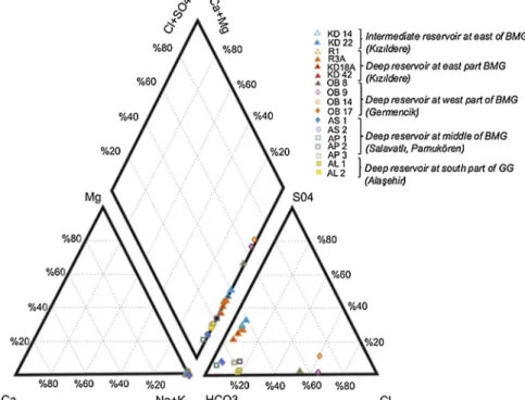
systems. The water types of the thermal waters are given inFigs. 5 and 6.
In the study area, the distribution of reservoir temperatures is compatible with the Na/K ratio in thermal waters. The value tends to increase to middle of the BMG and it is higher than in the GG. A Na-K-Mg triangular diagram is used to evaluate equilibrium between the hot waters and rocks at depth to understand water-rock interaction at depth and to estimate reservoir temperature. Almost all the thermal waters plot as partially equilibrated waters in a Na-K-Mg diagram (Fig. 7). The figure shows that water-rock interaction in the west part of the BMG is slightly greater than in other thermal waters in the study area. It sug-gests a deeper or longer circulation for the BMG waters.
The results of the water chemistry studies demonstrate that the main differences are observed in the Cl−, SO
42-, B and Li ion con-centrations in the thermal waters of the study area. Boron, Li+, Cl−and SO42-values increase from the east to the west along the BMG. The SO42-concentration is generally controlled by dissolution of gypsum and/or oxidation of pyrite, which suggests a thermal water reservoir (Gemici and Tarcan, 2002). The Cl−, SO42-and boron concentration of thermal waters are similar to that in the west part of the BMG in the GG. Li+ is generally present with Cl− and B ions and these distinguish waters from common sources (Fig. 8). It also indicates a decrease in concentration with increasingflow to the surface and with increased lateral flow in geothermal reservoirs (Nicholson, 1993). High Cl− concentrations indicate a deep feeding system of thermal waters, and that cold-water intrusion must be minimal in this case. However, if Cl-concentrations exceed 1000 mg/l in thermal waters, it suggests marine sediments in the reservoirs. (Nicholson, 1993).
In the study area, the highest Cl−concentrations were observed in the Germencikfield (1280–1740 mg/l), which is located 30 km from the Aegean Sea. The Cl−concentrations range from 73 to 293 mg/l, suggesting a marine sediment (paleo sea) effect in the Germencik re-servoir, as confirmed byKarakuş and Şimşek (2013), andGüner and Yıldırım (2005). The GG waters contain higher Cl−concentrations than those of the eastern part of the BMG. For Cl/B ratios; seawater has a high Cl/B, while magmatic volatiles have a low Cl/B ratio (Aggarwal et al., 2000). The Cl/B ratio has been given as 1.941 for the Aegean Sea Table 2
δ18O -δ D and δ13C- CO
2isotopes for thermal waters in the study area.
Field Well ID Sampling date δ18O‰ δ D ‰ References δ13C-CO
2‰ References
Kızıldere KD14 2013 −4.72 −52.09 In this study −0.62 Mutlu et al., 2008
KD22 2013 −5.64 −55.01 In this study
R1 2013 −4.09 −53.22 In this study
R3A 2013 −3.76 −54.37 In this study −0.03 In this study
KD18A 2013 −5.49 −58.44 In this study
KD42 2014 −4.1 −54.39 In this study
Germencik OB8 1998 −2.27 −41.9 Şimşek, 2003 −0.33 Karakuş and Şimşek, 2013
OB9 1998 −1.74 −37.9 Şimşek, 2003
OB14 2007 −1.24 −38.9 Karakuş and Şimşek, 2013
OB17 2008 −1.46 −39 Karakuş and Şimşek, 2013
Salavatlı AS-1 2011 −2.78 −48.78 Tarcan et al., 2013 −0.2 Karakuş and Şimşek, 2013
AS-3 2011 −2.17 −48.43 Tarcan et al., 2013
Alaşehir AL-1 2010 −2.33 −48.51 In this study −3.13 In this study
Al-2 2011 −1.94 −50.41 In this study
Table 3
δ34
S-δ18O (SO4) isotopes of thermal waters in the study area.
Geothermal Systems Graben System
δ34S‰ δ18O in (SO 4) ‰
References
Kızıldere Intermediate BMG 20 2.7 In this study
Kızıldere Deep BMG 21 1.3 In this study
Alaşehir (AL-1) GG 4.8 – In this study
Alaşehir (AL-2) GG −1.6 – In this study
Alaşehir (AL-3) GG −2.7 12.3 In this study
Alaşehir (AL-4) GG 1.7 11.9 In this study
Table 4
Gas composition of thermal waters in the study area (aYıldırım and Yıldırım, 2015;b,cAksoy et al., 2019;Tarcan et al., 2013;dHaizlip Robinson et al., 2013).
Geothermal Systems Graben System NCG (wt)% CO2% H2S % Ar % N2% CH4% H2%
Kızıldere Intermediate (KD22) BMG 1.5 99.1 0.042 0.0036 0.568 0.24 0.0024
Kızıldere Deep (KD23B well) BMG 2.5-3 98.8 0.08 0.0023 0.69 0.45 0.0043
Salavatlıb,c BMG 1 98 0.112 0.184 0.91 0.25 0.036
Germencikd BMG 1.3-1.7 98.5 0.21 0.001 0.44 0.7 0.035
byGemici and Tarcan (2002). The geothermal systems in the study area can be arranged with respect to Cl/B ratios from high to low as:
Germencik (Cl/B: 30), Pamukören (Cl/B: 6.5) Kızıldere (Cl/B: 4.2), Salavatlı (Cl/B: 2.4) and Alaşehir (Cl/B: 2). Cl/B ratios of Pamukören samples look suspicious with quite different results and one of them is selected as representative in the evaluation. The origins of boron in thermal waters have been discussed by different researchers (Gemici and Tarcan, 2002; özgür et al, 2004; Vengosh et al., 2002; Tokçaer, 2007). Leaching B3+ from the boron-bearing mineral phases in the metamorphics and as magmatic volatiles, B (OH)3gas intrusions are a known origin of boron in geothermal systems (Karakuş and Şimşek, 2013). Although the Cl/B ratio suggests a common reservoir source for waters, sometimes the ratio may differ due to the effects of a change in lithology at deeper zones in a geothermalfield (Nicholson, 1993). The sericite, illite, tourmaline minerals of the Menderes Massif are con-sidered to be one reason for the high boron concentrations in thermal waters due to water-rock interaction. Linear correlation between HCO3 and boron concentrations in thermal waters show that boron minerals have co-existed with carbonates in the reservoirs in Western Anatolia. Fig. 5. Piper Diagram of the thermal waters in the study area.
Fig. 6. Schoeller diagram of thermal waters in the study area.
Fig. 7. Thermal waters on Na-K-Mg Triangular diagram for the study area (Giggenbach, 1988).
Gülensoy and Kocakerim (1978)mentioned that the solubility of boron minerals in carbonate (such as colemanite) increase with high CO2gas concentrations in thermal waters. Aqueous species of boron can be sensitive to the pH offluids. At low pH B(OH)3and at high pH (> 8) conditions B(OH)4 can be the dominant species (Gemici and Tarcan, 2002). Along the BMG, deep geothermalfluids are acid character with a pH around 5.5–5.9 in Kızıldere and 4.9–5.5 in the Germencik systems. This suggests that the Germencik deep reservoirfluids are slightly more acid than those in the Kızıldere reservoir and it is noted that their boron concentration is higher too. These results show similarity with those of Gemici and Tarcan (2002). The pH of thermal water is an important criterion for the solubility of boron in the reservoirs and it may also explain the boron concentration in the Alaşehir field waters.
Beside the all identified geothermal reservoir conditions, local rock leaching may affect water compositions in a geothermal system. The concentration of Cl− and boron show differences in geothermal sys-tems. The boron concentration in sedimentary rocks may higher than volcanic rocks (Ellis and Mahon, 1977). The boron concentration is prominently higher in the GG than the BMG waters. Li+is an alkali metal and is affected by secondary processes. Thus, it is used as a tracer for the initial deep rock dissolution process and to evaluate the possible origin of two important conservative constituents of thermal water. The boron concentration of thermal waters shows the degree of maturity of a geothermal system (Rahmani, 2017). Li+ concentrations increase from the eastern part to the western part along the BMG. The Cl− concentration shows the same trend at the GG and it is higher than Kızıldere waters in the BMG. Li+
concentrations and the reservoir temperatures generally show a linear relation, however sometimes Li+ may be absorbed by clay minerals at depth.
Remarkable variations can be observed in SO42− concentrations along the BMG. The highest SO42−concentrations were recorded in Kızıldere (649–761 mg/l) at the eastern end of the BMG, and the lowest SO42−concentrations were recorded in Germencik (19.5–53 mg/l) in the west of the BMG. This is quite interesting because gypsum can be seen throughout the graben but the content of the SO42−is quite dif-ferent in thefluids of the geothermal fields at each end of the graben. A low SO42−concentration in Alaşehir waters suggest a similar trend as in Germencik waters.
Dissolved silica is an important constituent for predicting geo-thermal reservoir temperatures at depth. Silica is an important para-meter for geochemists, thus it is extremely important to prevent pre-cipitation during the sampling preparation or collection of the sample and get representative results for the reservoirs. Silica concentrations are generally compatible with reservoir temperatures for both graben systems (Table 1).
6.2. Variations in stable isotope composition along the BMG and GG Systems
Water-rock interaction studies show that increasing reservoir tem-peratures provide positiveδ18O shifts from the global meteoric water line (GMWL;Craig, 1961), while there is no effect on δ D because of a small interaction with hydrogen in the reservoir rocks.
The maximumδ18O shift (−2.27‰; −1.24‰) from the GMWL is shown in the Germencik geothermalfield while δ18D values vary be-tween−37.9 and −41.9‰ (Fig. 9) in the west of the BMG. Theδ18O is more positive in the deep reservoir (−3.76; −4.09) than in the inter-mediate reservoir (−4.72 and −5.64‰) of Kızıldere geothermal system (Table 2). In Salavatlı, the δ18O value is around−2.17‰. It is thought that the main reason ofδ18O shift in the geothermal system is the marbles of Menderes Metamorphics. In the Alaşehir fluid, δ18O values for thermal waters are around −1,94‰ and δD values vary between −48.51 and −50.41‰ in the GG. The δ18O values suggest that all the thermal waters in the study area are from deep feeds and have taken part in an intense water-rock interaction, but isotope values are lower for Kızıldere fluids than those from other fields in the BMG
and Alaşehir, since reservoir permeability is lower in Kızıldere. It is noted that the CO2concentration in reservoirfluids may also affect the δ18O shift in the GMWLfluids due to an increasing mineral dissolution in the reservoir (Fig. 9,Haklıdır Tut, 2013). The differences in stable isotope values could be likely related to differences in meteoric water recharge variations along the BMG.
13δC values can be used to understand the origin of CO
2in a geo-thermal system. Thermal waters in volcanic areas or along tectonic zones have elevated PCO2values that show a subsurface contribution. This mantle-derived CO2has been detected in geothermal waters and has been found to have a13δC value around −6‰ (Clark and Fritz, 1997). Another CO2source is thermal metamorphism of limestone in the reservoir. When rising magma comes into contact with carbonate decarbonation of CaCO3takes place, with loss of CO2.
When CO2(g)diffuses into water, it forms four main components of dissolved inorganic carbon (DIC); dissolved or COaq, H2CO3, HCO3− and CO32-and their relative concentration in water is a function of pH. Different isotope fractionation factors exist between these aqueous species and gas (Clark and Fritz, 1997).Ellis and Mahon (1977)state that bicarbonate ions decompose on reaction with weak acids in geo-thermal waters.
If a geothermal reservoir contains CaCO3; thermal water is assumed to be in equilibrium with calcite and the solubility will be defined by Eq.(1); in the presence of acid dissolution of CaCO3forms CO2based on the following reaction (Ellis and Mahon; 1977; Eqs.(1)and(2)); CaCO3(s) + 2 H(aq)+↔ Ca2+(aq) + H2O(l) + CO2(aq) (1) where the equilibrium constant; KCaCO3= (aCa2+* aCO2)/(aH+)2 (2)
The second equation shows the dissociation of dissolved CO2. Arnorsson (1989) describes the relationship of the equilibrium con-stants of these reactions as follows;
Kcalcite*KH2CO3*KHCO3− = Kcalcite (3)
where KH2CO3 is the equilibrium constant for the first dissociation constant of dissolved CO2. The dissociation of H2CO3produces HCO3− as follows (Eq.(4));
H2CO3= HCO3−+ H+ (4)
The second dissociation constant of carbonic acid, KHCO3, produces CO32−as follows; CO32-+ H+= HCO3- (5)
Fig. 9.δ18O versusδD diagram for the study area thermal waters (GMWL:
Global Meteoric Water LineδD = 8*δ18O+10; (Craig, 1961);
MMWT:Mediterra-nean Meteoric Water LineδD = 8*δ18O+22; LMWL:δD = 8*δ18O+16 (Karakuş
The carbonate concentrations in most of geothermal reservoirs are observed in equilibrium with calcite;
CaCO3+ CO2+ H2O = Ca2++2HCO3− (6)
Eq. (6) shows that at constant temperature in equilibrium with CaCO3while, CO2is controlled by aCa2+and aHCO3-. However, aHCO3-is controlled by the dissociation of dissolved CO2(Eq.(4)) and the pH value (Haizlip Robinson et al., 2016). In geothermalfluids, other acids may also affect the pH such as silicic acid, sulfuric acid, boric acid.
The13δ C values for the thermal waters are quite similar in the BMG and the values are slightly lower in the GG (Table 2). The origin of the high CO2concentrations are mainly due to the decomposition of car-bonate in the marble in the different geothermal reservoirs (Clark and Fritz, 1997) along the BMG and the GG (Fig. 10). In the study area; the main source of CO2is found marble in Paleozoic aged Menderes Me-tamorphics and there is no evidence of a magmatic influx in the BMG geothermal systems. Limited data exists on13δ C in the GG region and it is not easy to explain differences in13δ C in BMG (−0.03; −0.062‰) and GG (−3.13‰). The measured pH of the waters (pH is around 7) is lower in GG than BMG’s waters (pH is around 8) and high sulfate (∼500 mg/l) and weathering of silicate minerals in carbonate systems (Clark and Fritz, 1997) may be the reason of the slight differences in13δ C values between the two graben systems (Fig. 10).
The concentration of SO42−is generally lower than 50 mg/l in deep geothermal reservoirs but the concentration increases by the oxidation of condensed H2S (Nicholson, 1993). The concentration of sulfate can also be highly variable that it may be derived from dissolution of sulfate minerals (e.g., gypsum and anhydrite), oxidation of sulfides (such as pyrite) and biological activity (Nicholson, 1993;Liua et al., 2017) in thermal waters.
Sulfur species are detected as dissolved sulfate (SO42−), the dis-solved sulfide (HS-) or H2S gas in the water. The form of H2S depends on the pH of the water and if the pH of the water is lower than 6, H2S is mainly in the form of H2Sgas. When the pH increases to 6–8, a part of the H2S converts into HS- and a mixture of H2S and HS- exists at these pH levels. Above a pH of 13, S2−is the major ion in water (Mcvay, 2007).
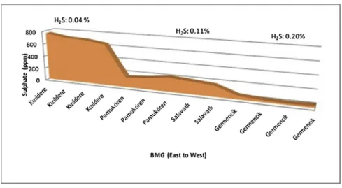
SO42−concentrations tend to decrease from east to west in thermal waters along the BMG (Fig. 11). The concentration of the ion reaches a maximum value of 760 mg/l in Kızıldere water and it decreases to 20 ppm in Germencik water. Oxidation of thefluid lowers the H2S gas concentration as the gas is oxidised to the SO42ion and the CO2/ H2S ratio increases in geothermal systems (Nicholson, 1993). The H2S gas percentages in NCG show an opposite trend to dissolved SO42−along the graben (Fig. 11). H2S% in the gas phase in Kızıldere and Germencik fluids show remarkable differences along the BMG. Geothermal fluid offers diversity in pH and temperature both of which increase the
solubility. In Germencik, the pH of geothermal fluids is found to be lower than in Kızıldere fluids because of a marble dominated reservoir (Osborn et al., 2007). In addition to the pH value, the concentration of H2S increases with temperatures (Blamey, 2006) and the highest re-servoir temperature is recorded as 276 °C in Germencik along the BMG. The low pH and high reservoir temperatures conclude higher H2S concentrations in Germencik and Alaşehir than the other geothermal fields.
It is supported byGiroud and Arnórsson (2005)that they referred to lower pH and high temperature effects, refer to specific mineral buffers with regard to CO2and H2S concentrations in high temperature sys-tems.Blamey (2006)also supports this idea and the purpose of a cor-relation between the H2S concentration and temperature which is controlled by pyrite-pyrrhotite-magnetitE–Water equilibrium in geo-thermal systems.Norman et al. (1998)describes the CO2-CH4-H2S-H2 O-magnetite-pyrite-pyrrhotite equilibrium conditions in geothermal sys-tems with Eq.7. This may explain the lower H2S concentration and trace CH4composition in Kızıldere but not in Germencik geothermal fluids, because of iron mineralization and the presence of magnetite in the Kolonkaya and Tosunlar formations (özgür, 2002).
2Fe3O4+12H2S + CO2= 6FeS2+ 10H2O + CH4 (7) In addition to the reservoir conditions in the study area, the tracer tests show that that there may be better connections between fractures in the Alaşehir and Germencik geothermal systems than in the Kızıldere geothermal system (Aydın et al., 2018;Hamendi, 2009; Yeltekin and Akın, 2006). The transmissibility of the Kızıldere reservoirs may give enough time for sulfide oxidation. One other possibility regarding high H2S in Germencik is a possible paleo-sea water effect (Filiz et al., 2000). Thefield is only 30 km far away from the Aegean Sea andGüner and Yıldırım (2005)report a 7–8 % sea contribution; possibly from marine sediments, because of Mediterranean transgression in the Pleistocene in the Germencik geothermal reservoir. The may also explain the high compressed organic material concentration in sediments and the sulfur concentration in the reservoirfluids.
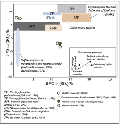
34S isotopes have been used to interpret the origin of sulfur how-ever, sulfur is highly fractionated due to biological effects and the δ18O ratio of sulfate is an important tracer in understanding of the origin of sulfur (Clark and Fritz, 1997). These variations occur depending on differences in temperature and oxidation-reduction reactions which are acting on sulfur concentrations (Seal, 2006)
δ34S values of Kızıldere thermal waters are around 20‰ while, the values for Alaşehir waters vary between −2,37 and 4‰. To better understand the origin of the sulfur for both grabens, SO42− con-centration versusδ34S graph is givenFig. 12. Based on the graph; the source of sulfate is from evaporitic gypsum in Kızıldere thermal waters and a mantle sulfur contribution is important for Alaşehir thermal waters.
Clark and Fritz (1997)mentioned that terrestrial sulfate could be distinguished from marine sources by their isotopic composition. The δ34S content of sulphate from oxidation of that form of sulfide is gen-erally depleted from original sulfide. For δ18O ratio of sulphate is more complex due to atmospheric O2and oxygen in water present during oxidation can have an influence. To minimize the fractionation, a δ34
S-SO4versusδ18O - SO4diagram can possibly explain the origin of the sulphur in a region.Rajchel et al. (2002)noted thatδ34S of total dis-solved sulfur cannot be changed by probable bacterial reduction or by oxidation reactions in a closed system. Organic sulfur may suppose the presence of hydrocarbons in the reservoir andözdemir (2019)stated that the dykes and sills in BMG could be effective to formation of hy-drocarbons. With this reason, it is proposed that the magmatic source contribute to the total sulfur amount beside the hydrocarbons in the west part of the BMG and Alaşehir in GG (Fig. 12).
InFig. 13Alaşehir and Kızıldere high temperature waters are shown in different parts of the graph. Alaşehir fluids contain a low SO42−
concentration in the water phase and a high H2S concentration in gas phase like the Germencik waters in the BMG (Table 2 and Table 3) However, Alaşehir is distinctly far from a sea intrusion effect and has lower Cl- concentration in thermal waters than Germencik. Based on Fig. 13, it is possible that sulfide minerals in the Alaşehir field can be oxidized at a near surface depth while, bacterial reduction is also pos-sible in the Kızıldere field.
The chemical equation for the reaction between SO42−and H2S is shown for the geothermal waters in Eq.(8).
SO42−+ 2Corganic+ 2H2O + microbial activity = H2S + 2 HCO3 -(8)
6.3. Gas composition in the BMG and GG geothermal systems
The NCG composition in the steam phase is of importance for both emission calculation and power plant design in geothermalfields. Along the BMG graben, the gas ratios in the steam and gas phase are calcu-lated as 1–2 %wt in the intermediate reservoir fluids (Haklıdır Tut et al., 2011;Serpen and Aksoy, 2010) and 3–3.2 %wt (Haizlip Robinson et al., 2013;Haklıdır Tut et al., 2011) in the deep reservoirfluids. The dominant gas is CO2with 95–99% in NCG both graben systems. CO2is the least soluble gas and it enters steam phase faster than H2S and others (Nicholson, 1993).Ellis (1962)andNicholson (1993)state that gas solubility in the liquid phase increases with temperature and H2S may be 2–3 times more soluble over 200–260 °C and the solubility of these gases decrease with increasing salinity of the waters. The pH of
water is one of the factor to solubility of H2S between liquid and gas phases in a geothermal system (CEC, 1980). In the BMG geothermal systems, other, less prominent gases can be classified as minor amounts of N2and CH4and trace amounts of NH3, H2S and H2. Detailed NCG data are available for the Kızıldere and the Germencik fields, allowing for the comparison of the non-condensable gas component concentra-tions, except for CO2in the western and eastern parts of the BMG.
One of the corrosive gases is H2S, whose concentrations are very different in the Kızıldere and the Germencik fluids. The H2S gas results indicate that H2S concentrations in the Kızıldere geothermal fluids are one-tenth of the H2S concentrations found in the Germencik geothermal fluids. The water chemistry supports these values, because the SO42− concentrations are over ten times higher in the Kızıldere geothermal fluids than the Germencik fluids. This may be the result of oxidation of H2S because of the higher reservoir pH in the Kızıldere waters than in the Germencik waters. The presence of high H2S and high Cl- may generate a more acid milieu in the Germencik reservoir. NCG compo-sition of Alaşehir reservoir fluids shows similarity to that of Germencik fluids. The H2S concentration is also high in Alaşehir fluids. The origin of the H2S may be due to hydrocarbon reserves almost 3 km away from thefield. In 2008, a potential oil zone was discovered in Sarıkız-2 well at 1.8 km depth by a private company (Gürgey et al., 2014). Hydro-carbon traces in well logs have been detected during a few geothermal drilling operations (for example Piyadeler village; Zorlu Energy licence area) in the Alaşehir region.
CH4is a hydrocarbon gas and the concentration of CH4is slightly higher in Germencik reservoir fluids than Kızıldere reservoir fluids
Fig. 11. Dissolve SO42−and H2S(g)distribution along the BMG.
along the BMG graben. The Germencik and Kızıldere fluids have quite similar He gas concentrations. Karakuş and Şimşek (2013) and Wiersberg et al. (2011)suggest a low mantle-He contribution for both fields based on their detailed3He isotope studies.
7. Conclusions
The large graben systems possess remarkable geothermal systems in Western Anatolia. Although the main reservoir geology indicates si-milarities between the BMG and the GG, the geofluids show different chemical and isotopic compositions. In the water phase, Cl−, SO42-, Li and boron ion concentrations show remarkable variations along the BMG from the western to the eastern line. The Germencikfluids have higher Cl−, Li and B ion concentrations, and the lowest SO42- con-centration in the BMG. The Cl−and boron concentrations tend to de-crease from the Germencik to the Kızıldere geothermal reservoirs along the graben. The Kızıldere SO42-values are the highest in the graben. In the Germencikfield, where there is the highest water-rock interaction along the graben, stable isotope values indicate a marine sediment ef-fect; although, similar reservoir temperatures exist within the Kızıldere geothermal field. The Alaşehir geothermal fluids contain the highest boron concentration as in the GG among all geothermal systems in the study area. The system is shallower than the BMG geothermal systems, the lower Na/K values indicate a shorter water-rock interaction dura-tion. Meanwhile, theδ18O values for the thermal waters demonstrate a positive shift from the GMWL. High Cl−, boron concentrations may lead to lower pH values due to CO2effects in the Alaşehir geothermal fluids. Along the BMG, a striking change on SO4has been detected in the water phase. From the west to the east of the BMG, SO4ion con-centration increase in water phase while, H2S is decreasing in the gas phase. This may be the result of the lower pH, the higher temperature of
the reservoir than in the other geothermal fields and a high con-centration of organic material due to paleo-marine sediments in the Germencik geothermalfield.
The origin of the sulfur appears different between the edges of BMG geothermal systems. The non-condensable gas compositions in the west edge of the BMG and the GG show similarity. The isotope results in-dicate that the origin of sulphur looks gypsum in the east edge of the BMG while mantle sulfur contribution is possible for Alaşehir geo-thermal system in the GG. Although both these graben systems have different type hydrocarbon evidences, oil wells exist close to Alaşehir geothermal system in the Gediz Graben.
It is proposed that high reservoir temperatures and magmatic origin gases cause more acidic reservoir conditions in the west part of the BMG and the GG geothermal systems. These acidic reservoir conditions di-rectly affect fluid chemistry by leaching of rocks in these systems. It is suggested that together with the stable isotope values, the Germencik and the Alaşehir production wells are closer to the heat source than the Kızıldere and the other geothermal fields in the study area. It is thought that measured reservoir temperatures at 276 0C in the Germencik geothermal system and at 2500C in the Alaşehir and at 2870C 15 km far from the Alaşehir have been supported this suggestion.
Declaration of Competing Interest
The authors declare that they have no known competingfinancial interests or personal relationships that could have appeared to influ-ence the work reported in this paper.
Acknowledgement
The authors gratefully thanked Dr. Halldór Ármannsson for detailed
Fig. 13.δ34S versusδ18O - SO