COLOR CONTRIBUTION TO CHILDREN’S WAYFINDING
IN SCHOOL ENVIRONMENTS
A THESIS
SUBMITTED TO THE DEPARTMENT OF
INTERIOR ARCHITECTURE AND ENVIRONMENTAL DESIGN AND THE INSTITUTE OF FINE ARTS
OF BİLKENT UNIVERSITY
IN PARTIAL FULFILLMENT OF THE REQUIREMENTS FOR THE DEGREE OF
MASTER OF FINE ARTS
By Elif Helvacıoğlu
I certify that I have read this thesis and that in my opinion it is fully adequate, in scope and in quality, as a thesis for the degree of Master of Fine Arts.
__________________________________________ Assist. Prof. Dr. Nilgün Olguntürk (Principal Advisor)
I certify that I have read this thesis and that in my opinion it is fully adequate, in scope and in quality, as a thesis for the degree of Master of Fine Arts.
__________________________________________ Assoc. Prof. Dr. Feyzan Erkip
I certify that I have read this thesis and that in my opinion it is fully adequate, in scope and in quality, as a thesis for the degree of Master of Fine Arts.
__________________________________________ Assist. Prof. Dr. Ufuk Doğu Demirbaş
Approved by the Institute of Fine Arts
__________________________________________ Prof. Dr. Bülent Özgüç, Director of the Institute of Fine Arts
ABSTRACT
COLOR CONTRIBUTION TO CHILDREN’S WAYFINDING IN SCHOOL ENVIRONMENTS
Elif Helvacıoğlu
M.F.A. in Interior Architecture and Environmental Design Supervisor: Assist. Prof. Dr. Nilgün Olguntürk
May, 2007
The purpose of this study is to explore the contribution of color to children’s wayfinding ability in school environments and to examine the differences between different colors in terms of their remembrance and usability in route learning process. The experiment was conducted with three different sample groups for the three different experiment sets that were differentiated by their color arrangement. The participants were a total of 100 primary school children aged 7-8 years-old. The study was conducted in five phases. Firstly, participants were tested for color vision deficiencies and familiarity with the experiment site. Secondly, they were escorted on the experiment route by the tester one by one, from starting point to the end point and were asked to lead the tester to the end point by the same route. Thirdly, they were asked to verbally describe the route. Fourthly, they were asked to recognize the specific colors at their specific locations. Finally, they were asked to direct the location of the end point with their finger. It was found that color has a
significant effect on children’s wayfinding and pointing task performances in school environments. However, there were not any differences between different colors in terms of their remembrances in route finding task. In addition, the correct identifications of specific colors and landmarks were depending on their specific locations. Contrary to the literature, gender
differences were not found in the accuracy of route learning and pointing task performances.
Keywords: Wayfinding, Route Knowledge, Pointing Task, Color, School Environment.
ÖZET
ÇOCUKLARIN OKUL ORTAMLARINDA YOL BULMA YETİSİNE RENGİN KATKISI
Elif Helvacıoğlu
İç Mimarlık ve Çevre Tasarımı Bölümü, Yüksek Lisans Tez Yöneticisi: Yrd. Doç. Dr. Nilgün Olguntürk
Mayıs, 2007
Bu çalışmanın amacı, okul ortamında çocukların yol bulma yetileri üzerinde rengin katkısını araştırmak ve farklı renklerin, rota öğrenme sürecindeki etkilerini, hatırlanma ve kullanılma çerçevesinde incelemektir. Deney, renk düzenlemeleri ile birbirinden farklılaşan üç farklı deney seti için, üç farklı katılımcı grubu ile uygulanmıştır. Katılımcıların hepsi, 7 ve 8 yaş grubu olmak üzere, toplamda 100 ilkokul öğrencisini kapsamaktadır. Çalışma, toplam beş aşamadan oluşmaktadır. İlk olarak katılımcılar, renk görme yeterliliklerini ve deney alanına olan aşinalıklarını ölçmek üzere test edilmişlerdir. İkinci olarak, araştırmacı tarafından teker teker başlama noktasından bitiş noktasına kadar olan deney rotasında eşlik edilmiş ve daha sonra kendilerinden aynı rota düzeninde araştırmacıya, rotanın son noktasına kadar kılavuzluk etmeleri istenmiştir. Üçüncü olarak, rotayı sözel olarak tarif etmeleri istenmiştir. Dördüncü olarak, belli renkleri belli konumlarında ayırt etmeleri istenmiştir. Son olarak, işaret parmaklarını kullanarak, rotanın son noktasının konumunu işaret etmeleri istenmiştir. Rengin, çocukların okul ortamında yön bulma ve yön gösterme yetileri üzerinde önemli bir etkisi olduğu bulunmuştur. Ancak, farklı renklerin rota öğrenme durumunda, hatırlanma ve kullanılma
çerçevesinde birbirlerinden farklılıkları gözlenmemiştir. Buna ek olarak, belli renk ve yön bulma işaretlerinin doğru saptanmasının, kendi belli konumlarına bağlı olduğu bulunmuştur. Literatüre ters olarak, rota öğrenme ve işaret etme performanslarında, cinsiyete dayalı farklılıklar gözlenmemiştir.
Anahtar Sözcükler: Yol Bulma, Rota Anlama, Yön Gösterme, Renk, Okul Ortamı.
ACKNOWLEDGEMENTS
I would like to thank Assist. Prof. Dr. Nilgün Olguntürk for her invaluable supervision, guidance and encouragement throughout the preparation of this thesis. It has been a pleasure to be her student and to work with her.
I express appreciation to Assoc. Prof. Dr. Feyzan Erkip and Assist. Prof. Dr. Ufuk Doğu Demirbaş for their helpful suggestions.
I would like to thank Prof. Dr. Fatin Sezgin for his guidance and suggestions throughout the statistical analyses of the thesis. In addition, I would like to thank Nilgün Bulhaz and Nazlı Yılmaz for their help in making it possible to conduct the experiment on the site.
I owe special thanks to my roommate Aslı Çebi for her friendship, help and patience. I would also like to thank Güliz Muğan for her help. I would like to thank Aslı Yılmaz, İpek Sancaktar, Yasemin Afacan, Fatih Karakaya, and Erhan Dikel for their friendship and moral support. In addition, I owe special thanks to my dearest friend Alpaslan Güneş for his incredible support and trust.
I am grateful to my parents Kadir Helvacıoğlu, Oya Helvacıoğlu, my sister Sibel Helvacıoğlu, my brother Cem Helvacıoğlu and my aunt Didem
Helvacıoğlu for their invaluable support, trust and encouragement throughout the preparation of this thesis. Without their love and encouragement, nothing would be possible.
I dedicate this thesis to my parents Kadir Helvacıoğlu and Oya Helvacığlu, to whom I owe what I have.
TABLE OF CONTENTS
SIGNATURE PAGE ...ii
ABSTRACT...iii
ÖZET ...iv
ACKNOWLEDGEMENTS...v
TABLE OF CONTENTS...vi
LIST OF FIGURES ...x
LIST OF TABLES ...xi
1. INTRODUCTION 1 1.1. Aim of the Study ...2
1.2. Structure of the Thesis ...3
2. WAYFINDING 5 2.1. The Definition of Wayfinding...5
2.2. Wayfinding Design Strategies ...8
2.2.1. Architectural Wayfinding Design ...8
2.2.1.1. Layout...8
2.2.1.2. Landmarks...13
2.2.2. Informational Wayfinding Design...19
2.2.2.1. Orientation Aids...19
2.2.2.2. Signage ...22
2.3. Individual Differences in Wayfinding ...25
2.3.1. Familiarity ...26
2.3.2. Gender Differences ...27
2.4. Children and Wayfinding ...30
2.5. Children and Wayfinding by Route Learning...36
3. CONTRIBUTION OF COLOR IN WAYFINDING 40 3.1. The Theory of Color...40
3.1.1. Basic Color Terminology ...40
3.1.2. Perception of Color ...45
3.1.3. Psychological Responses to Color ...45
3.1.4. Physiological Responses to Color ...47
3.1.5. Individual Differences in Preferences of Color ...48
3.2. Color in Design ...50
3.3. Color in School Environments ...52
3.4. Color and Wayfinding ...54
4. THE EXPERIMENT 57 4.1. Aim of the Study ...57
4.1.1. Research Questions...57
4.1.2. Hypotheses...58
4.2. Method of the Study ...58
4.2.1. Sample Group ...58
4.2.2. Site Description ...59
4.2.3. Procedures ...61
4.2.3.1. Planning of the Experiment ...61
4.2.3.1.1. Selecting the Route...62
4.2.3.1.2. Establishing the Landmark Boxes...65
4.2.3.2. Sets of the Experiment...66
4.2.3.2.1. Specifying the Colors ...68
4.2.3.2.2. Specifying the Locations ...72
4.2.3.3. Phases of the Experiment ...73
4.3. Findings ...78
4.3.1. Effect of color on children’s route learning ability ...78
4.3.1.1. The accuracy of finding the end point...78
4.3.1.2. The time spent during finding the end point ...80
4.3.1.3. Getting the landmarks as reference points ...81
4.3.2. Relationship between different colors in their contribution to route learning ability ...88
4.3.3. Relationship between the colors and their locations in route learning process learning...91
4.3.4. Effect of color on the pointing task performance ...97
4.3.5. Effect of gender on route learning ...98
4.5. Discussion ... 100
5. CONCLUSION 105 6. REFERENCES 109 7. APPENDICES 118 APPENDIX A ... 118
APPENDIX A1. Exterior View of School Buildings... 119
APPENDIX A2. Floor Plan of the High School Building ... 121
APPENDIX A3. Interior View of the High School Building ... 123
APPENDIX B. Photographs of the Experimental Sets ... 133
APPENDIX C. Illuminance Map of the High School Building ... 137
APPENDIX D ... 141
APPENDIX D1. English Version of the Question Forms... 142
APPENDIX D2. Turkish Version of the Question Forms... 147
LIST OF FIGURES
Figure 3.1. A view showing NCS Color Circle ...43
Figure 3.2. A view showing one NCS triangle ...44
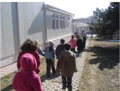
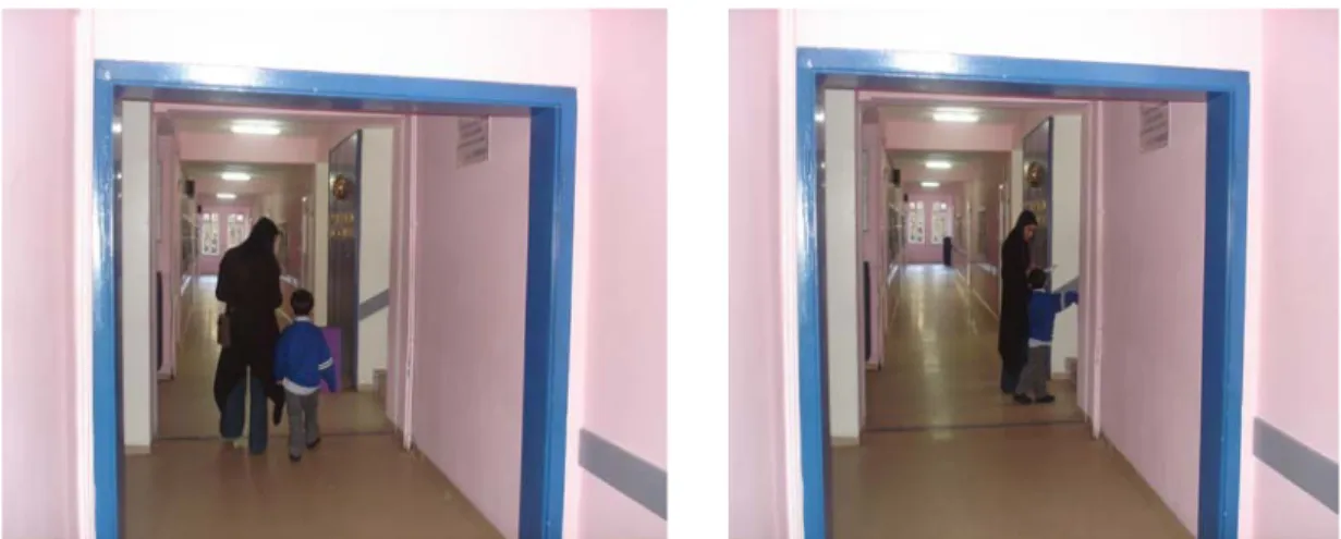
Figure 4.1. A view shows children being removed from their building to the high school building ...62
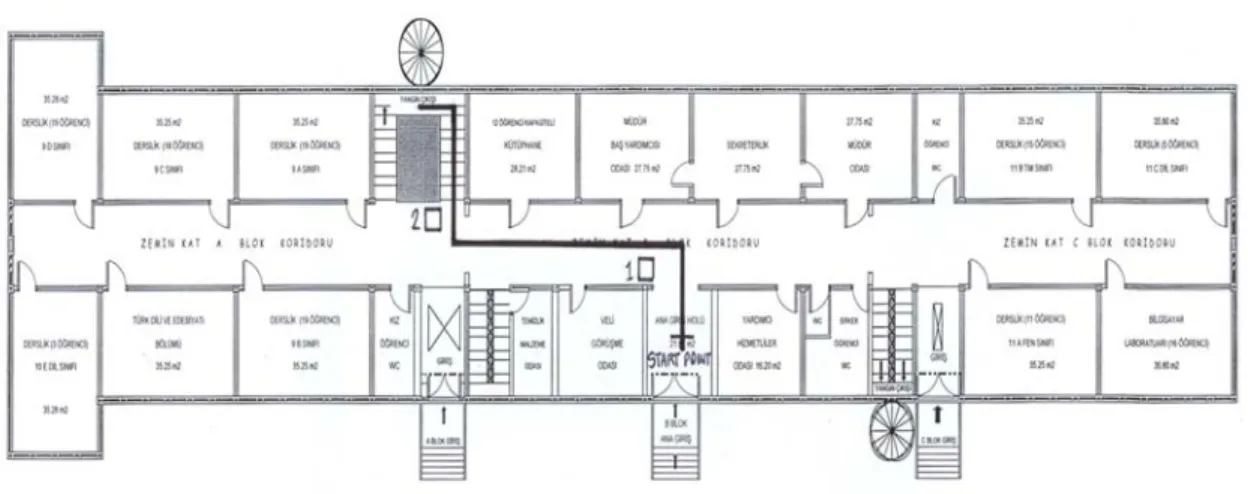
Figure 4.2. Ground Floor Plan of the high school building with selected route...63
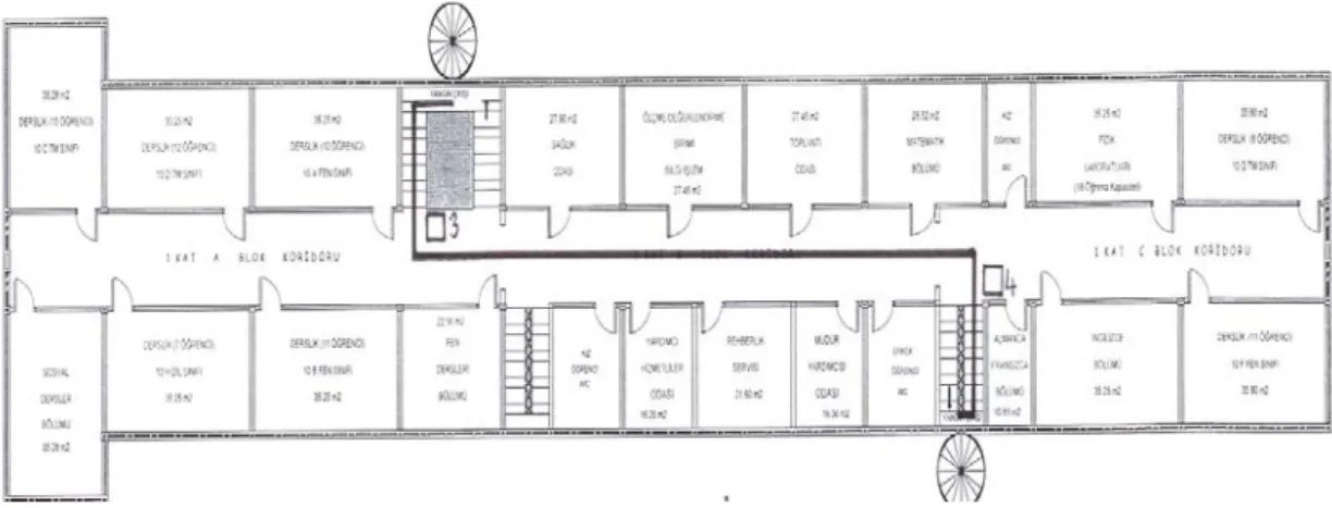
Figure 4.3. 1st Floor Plan of the high school building with selected route...64
Figure 4.4. 2nd Floor Plan of the high school building with selected route...64
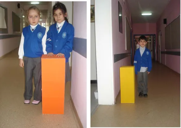
Figure 4.5 and 4.6. Views of the boxes with the proportion of the 7 year old female and male child height ...65
Figure 4.7. A view shows NCS Color Circle with selected colors ...69
Figure 4.8. A view showing the vertical and horizontal surfaces of the building...72
Figure 4.9 and 4.10. Views from the second phase of the experiment...75
Figure 4.11. A View from the third phase of the experiment ...76
LIST OF TABLES
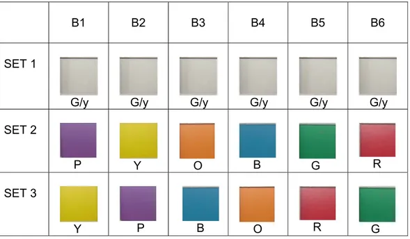
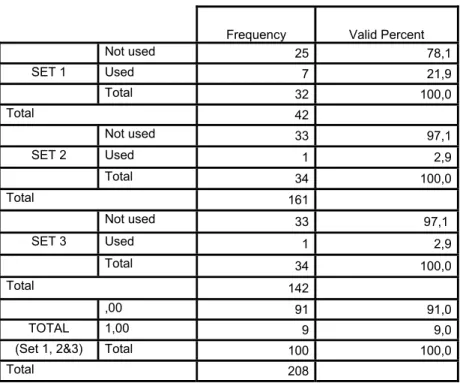
Table 4.1. Participant Numbers on the Basis of Set and Gender ...59 Table 4.2. Arrangement of Colors in Three Experiment Set. (Colors that were used in the experiment were specified from Natural Color
System Atlas)...67 Table 4.3. Selected Colors from NCS for the Experiment...71 Table 4.4. Frequency of accuracy in route learning ability with sample
Groups ...79 Table 4.5. Frequency for hesitations during route finding process with
sample groups ...80 Table 4.6. Frequency for time spent during route finding process...81 Table 4.7. Frequency for using boxes as reference points in verbal
description of the route with sample groups...82 Table 4.8. Frequency for using boxes in route learning process with
sample groups ...82 Table 4.9. Frequency for using building design elements as reference
points in verbal description process with sample groups ...83 Table 4.10. Frequency for building design elements that were paid
attention to on route learning process with sample groups...84 Table 4.11. Frequency for used building elements as reference points
in route learning processwith sample group ...85 Table 4.12. Frequency for the sample group that were paid attention
to the building elements...86 Table 4.13. Frequency for the elements that were paid attention to with
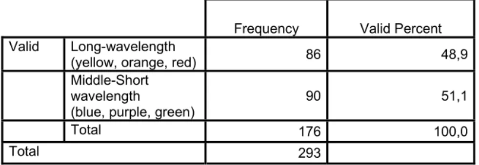
sample group ...86 Table 4.14. Frequency of accuracy in verbal description of the route with sample groups ...87 Table 4.15. Frequency for usages of directional terms in verbal description of the route with sample groups ...88 Table 4.16. Frequency for the memorability of the colors ...89 Table 4.17. Frequency for the effect of wavelength on memorability of
Table 4.18. Frequency for the effect of wavelength on usability of the
colors ...91 Table 4.19. Frequency for correct location identification of colors...92 Table 4.20. Frequency for recognizing the specific sequence of the
colors ...92 Table 4.21. Frequency for correct color identification of boxes...93 Table 4.22. Frequency for correct identification of colors and boxes
in relation with the floors...94 Table 4.23. Frequency for used colors as reference points on verbal
description...95 Table 4.24. Frequency for used boxes as a reference point on verbal
description...95 Table 4.25. Frequency for the used colors and boxes on verbal
descriptions of the experiment route, in relation with the floors ...96 Table 4.26. Frequency for the effect of wavelength on correct identification of colors ...97 Table 4.27. Frequency for pointing performances with sample group ...98 Table 4.28. Frequency for the effect of gender on route learning...99 Table 4.29. Frequency for the effect of gender on pointing task
1. INTRODUCTION
The difficulty of navigating in unfamiliar environments suggests the need to support navigation with the use of environmental design elements such as layout, landmarks, and signage, in real and virtual spaces. One tool for navigation is provided with color. Color is a very important tool in the design of environments for coding, navigation and wayfinding. It can help to develop a mental map of the architectural environment (Dalke, Little, Niemann, Camgöz, Steadman, Hill, Stott, 2005). However, there are only a limited number of studies available on the impact of color on human wayfinding ability.
Adults develop their sense of spatial learning in years. They know how to behave in a case of an inaccurate orientation in an environment and they can control their psychology towards feeling lost. However, it is different for children; by the age of 7, a child starts to understand his environment and then his/her understanding develops in time. By the age of 8, s/he
remembers the events at the beginning and at the end (Cornell, Heth, Kneubuhler, & Sehgal, 1996). So they need more support for navigating themselves in an environment and color might be such a support. The studies available generally focus on children’s pointing task abilities (e.g. Lehnung, Haaland, Pohl, & Leplow, 2001; Lehnung, Leplow, Haaland,
Mehdorn, & Ferstl, 2003) and spatial memories (e.g. Heth, Cornell, & Alberts, 1997; Osmann & Wiedenbauer, 2004; Bell, 2002). By the time of
life of children (Orr, 1992). They have their first experiences in their school and these experiences can positively or negatively affect children’s
psychology. Providing legible spaces for children may also contribute to their psychological health.
1.1. Aim of the Study
The main purpose of this study is to understand the contribution of color to children’s wayfinding ability in school environments. It is important to
understand how color affects children’s usage of their environment and their accuracy in wayfinding for providing them psychologically healthy
environments. In addition, different colors were tested in this study, in terms of their remembrance and usability in route learning.
This study points out the effects of color on children’s route learning performances in their natural environments, and the differences between colors in terms of their remembrance and usability in route learning process. The findings of the experiment may provide some clues not only for interior architects but also for sign makers and educators who may influence the design of safe environments with appropriate wayfinding cues to young children.
1.2. Structure of the Thesis
The thesis consists of five chapters. The first chapter is introduction, in which the importance of wayfinding is stated and the contribution of color to
wayfinding is briefly investigated. In addition, children’s development of spatial acquisition is discussed in general.
The second chapter explores the concept of wayfinding. Firstly, the definition of wayfinding, its importance on human psychology, its processes and requirements for the activity are stated. Secondly, wayfinding design strategies that are architectural wayfinding design and informational wayfinding design are explained. Layout of the space in the frame of form and configuration, circulation systems and scale, and landmarks that are used in spaces and are identified under the architectural wayfinding design strategies. Signage and orientation aids that constitute the building
information systems are identified under informational wayfinding design strategies. The definitions, usages and roles on wayfinding and importance in acquisition of spatial knowledge of these wayfinding design strategies are explained. Thirdly, individual differences in wayfinding skills are given. The effects of familiarity, gender and age differences on wayfinding skills are discussed. Lastly, children’s wayfinding abilities are elaborated on with the importance of wayfinding in school environments and route learning process.
In the third chapter, the contribution of color in wayfinding is examined. Firstly, the theory of color is stated with respect to the basic color terminology, perception of color, psychological responses to color and
individual differences in preferences of color. Secondly, the usage of color in design is given. The role of environmental color and its purposes in design are stated. Thirdly, color in school environments is discussed with respect to its importance in student’s performance and children’s wayfinding and spatial abilities in their environment. Lastly, the importance and the effects of color as a design tool in wayfinding are given.
In the fourth chapter, the experiment is described with the aim, research questions and hypotheses. The methodology of the experiment is defined with the identification of the sample group, description of the site and explanation of the experiment procedures. The results are statistically analyzed and evaluated. The research notes are also given to enrich the study. Finally, the results are discussed in relation to previous studies related to the subject.
In the fifth chapter, major conclusions about the study are stated and suggestions for further research are generated.
2. WAYFINDING
2.1. The Definition of Wayfinding
Awareness of the space around is an important issue for finding one’s way in environments. Finding one’s way around is a purposive, directed, and
motivated activity (Golledge, 1999). Wayfinding is the process of reaching a destination, whether in familiar or unfamiliar environments (Arthur & Passini, 1992). Giuliani (2001) defined wayfinding as “the organization and
communication of our dynamic relationship to space and the environment” (p.43).
Wayfinding is an activity that requires complete involvement with the environment (Passini, 1984). During this involvement, the wayfinders try to understand the setting they are in and with the information they obtained. According to Giuliani (2001) “successful design should allow people to: determine their location within a setting, determine their destination, and develop a plan that will take them from their location to their destination” (p.43). He also added that identifying, marking, grouping, linking and organizing spaces should be included in the design of wayfinding systems. Pollet & Haskell (1979) stated that wayfinding design involved
communication of information to help users of the building find their
Arthur & Passini (1992) state that wayfinding includes three specific but interrelated processes. These processes are; “decision making and the development of a plan of action; decision execution that transforms the plan into appropriate behavior at the right space; information processing
understood in its generic sense as comprising of environmental perception and cognition, which, in turn, are responsible for the information basis of the decision-related processes” (p.25).
Unfamiliar, large-scale and complex layout environments are difficult to navigate. Being unfamiliar with immediate surroundings and unable to determine how to correct the situation is an uncomfortable condition (Darken & Peterson, 2002). As Richter & Klippel (2002) asserted orientation in an unknown environment is an important factor for successfully reaching at a specified destination and requires usually external knowledge sources. People need to know where they actually are in complex unfamiliar
environments to feel themselves secure and safe. The difficulty of navigating in unfamiliar environments suggests the need to support navigation in real and virtual world spaces by environmental design elements.
Wayfinding necessitates spatial knowledge that contains one’s current location, destination and the spatial relation between them. Without this knowledge, if people do not get totally lost, they become disoriented (Cubukcu & Nasar, 2005). Disorientation can have serious consequences, such as stress. Disoriented people are anxious, uncomfortable and unhappy (Darken & Peterson, 2002). Passini (1984) stated that, disorientation and
getting lost are very frustrating experiences for people who are trying to reach a specific destination. Danielsson (2005) stated that for reducing the negative effects, the circulation system of the building should be easy to understand and the internal relations between spaces should be logical. Therefore, design for wayfinding is very important for improving people’s wayfinding performances in real environments.
A lost person is defined as “unable to identify or orient his present location with respect to known locations, and has no effective means method for reorienting himself” (Hill, 1998, p.2). Knowing where you are provides feelings of security and safety. Becoming lost is the result of losing one’s spatial orientation and is normally accompanied by high emotional arousals such as nausea, stomach pain and fear.
People do not feel themselves lost unless they are uncertain about how to get to their destination. People are considered to know where they are, if they state their location accurately within a frame of references (Cornell & Hill, 2004). Arthur & Passini (1992) state that people feel themselves disoriented “when they can not situate themselves within a spatial representation and when, at the same time, they do not have, or can not develop, a plan to reach their destination” (p.25). Previous experiences, reading and evaluating
environmental context and trying to understand the spatial characteristics of the setting are required information for solving wayfinding problems.
There are two types of wayfinding design strategies: architectural wayfinding design and informational wayfinding design (Pollett & Haskell, 1979 ; Giuliani, 2001). These strategies help people to construct their mental map about the environment. Architectural wayfinding design deals with the layout of the space and landmarks that are used in the space. Informational wayfinding design deals with the building information system that are signage and orientation aids. These categorization is about the fundamental distinction between sources of spatial knowledge, whether the information comes directly from the primary source of environment -architectural wayfinding design- or from some other secondary source -informational wayfinding design- (Darken & Peterson, 2002).
2.2. Wayfinding Design Strategies
Architectural wayfinding design and informational wayfinding design are the two types of wayfinding design strategies that provide sources of spatial knowledge to people.
2.2.1. Architectural Wayfinding Design
There are two primary architectural wayfinding design elements: layout of the building and landmarks that used in the building.
2.2.1.1. Layout
The spatial layout and other architectural features are important sources of information for finding one’s way, when focusing on wayfinding in large-scale built environments (Werner & Schindler, 2004). Doğu & Erkip (2000) stated
that layout of a setting could be defined by its spatial content, form,
organization and circulation system. The building tells us everything about its internal organization if these factors are articulated well. Buildings organized around an open core provide an advantage of visual and auditory access to circulation systems.
A building can be considered a design success, if it allows easy and error free navigation from a perspective of function (Werner & Schindler, 2004). Therefore, a building as a source of wayfinding information has to be architecturally legible.
Legibility that means the apparent clarity of the environment is one of the
important concepts of environmental psychology and is crucial in
environmental setting (Lynch, 1960). Legible environment “not only offers security but also heightens the potential depth and intensity of human experience” (p.5). Legibility means the degree to which a building or groups of buildings facilitate the ability of users to find their way around (Abu-Ghazzeh, 1996). Herzog & Leverich (2003) defined the term as “the ease of finding one’s way around in a setting, the ease in figuring out where one is at any given moment, or of finding one’s way back to any given point in the setting” (p.461). If the current view in a setting appears well structured, then it is legible. However, inappropriate architectural design might make a setting complex which might cause wayfinding problems.
Complexity in a setting can be described with the amount of different kinds of
elements that the scenes contain (Stamps, 2004). People need small amount of changes in a setting and, they do not adapt well to large amount of
variations. Therefore, a high level of complexity leads to an overabundance of stimulation (Evans & McCoy, 1998). Clear and organized settings could reduce wayfinding problems by creating spaces for making easy predictions. In complex settings, wayfinders are bombarded with stimulation of all sorts of information and as a result finding relevant information becomes difficult (Arthur & Passini, 1992). O’Neill (1991) found that complexity of floor plan influenced wayfinding performance negatively, when plan complexity was increased, errors were also increased.
People do not comprehend the overall plan of the building. Therefore, providing a legible spatial structure for a building is an important factor in way-finding performance and this is related with geometrical properties. The spatial structure of a building can be analyzed under three important issues: form and configuration, circulation system and scale of the building.
One significant predictor of wayfinding is building configuration that contains spatial content such as form, organization of floor plan configurations and circulation system. Design for wayfinding is based on spatial properties and analyses of floor plans of the built space. Spatial relations and differences in orientation between different parts of a building play an important role on human ability to organize and to integrate spatial knowledge (Werner & Schindler, 2004). Buildings that are organized around a simple orthogonal
grid with regular angles are less problematic than irregular designs.
Symmetry axes, elongation, use of visible structures such as an atrium, the outside landscape or other prominent features provide comprehensible environments. According to Haq & Zimring (2003), visibility is an important issue in movement as it is easier to find a destination that one can see. According to Başkaya, Wilson & Özcan (2004) the monotony of architectural composition and the lack of reference points increase wayfinding difficulties where visual access to the main destinations makes wayfinding facilities easier. They found that a regular but asymmetrical floor plan was easier to remember than a regular but symmetrical layout and a simple corridor system allowed for easy orientation.
Darken & Peterson (2002) commented that spaces with an understandable structure will have a great effect on the strategies used and resulting performances on navigation tasks. Providing some obvious landmarks can reinforce the shape of space. Environments that represent a logical traffic pattern permits user to move easily from one spot to another. Spatial organization, building layouts, destination zones and information sequence bring along success or failure in wayfinding abilities (Muhlhausen, 2006). Building configuration of an environment is an effective measure to
understand wayfinding difficulties in specific areas of complex buildings (Haq & Zimring, 2003). For physical environmental factors, Cubukcu & Nasar (2005) found that environments with simple layout and higher physical differentiation provided better spatial knowledge -lower error scores- than environments with complex layout and lower physical differentiation. The
simple layouts also had significantly lower selection, sketching and navigation errors than the complex ones.
The design of spaces affects user behavior and the flow of visitors in an environment. The shapes of spaces orientate the visitors. A simple plan of spaces plays an important orientation role by allowing visitor to concentrate on the purpose of the visit (Bourdeau & Chebat, 2003). Franz & Wiener (2005) supported the ideas that form and configuration of the architectural space influence experience and behavior of users. They also stated that when looking for a specific place especially in unfamiliar environments, during exploration, movement decisions include regular patterns that were caused not only by the shape and configuration of the environment but also by visual characteristics of decision points.
The circulation system is one of the key elements of a building that helps to develop a mental map. A well-designed circulation system provides users an easier understanding of the building (Arthur & Passini, 1992). Circulation system of the building should be identifiable and obvious for easy
understanding from the initial contact and important adjacent activities should be exposed to the circulation system (Pollett & Haskell, 1979).
Vertical circulation elements such as stairs, elevators, and ramps should be perceptible for maintaining easy communication to the users (Giuliani, 2001). Giuliani (2001) stated that the entries and circulation spaces were the first contact of people with the building interior. Thus, a sense of openness for
improving the acquisition of knowledge about the building layout and social organization should be provided.
Beside the building configuration and circulation system of the building, scale has also an important effect on understanding spaces. It is an important element in the acquisition of spatial knowledge. Scale affects user interactions with the space in navigation, in learning and reconstructing spatial locations, in recall of object location, and in verbal descriptions of spatial locations (Bell, 2002).
2.2.1.1. Landmarks
The content of environmental setting can conveniently be classified into five elements: paths, edges, districts, nodes and landmarks (Lynch, 1960). Those are providing a support to the improvement of wayfinding ability and to the development of route knowledge.
Paths are the channels along which people move potentially, and these are
the predominant elements in their cognitive image of a place (Lynch, 1960). Paths include walkways, hallways and corridors, which make the circulation system of the building. Paths are used in two orders: main pathways and secondary pathways in complex buildings. Main pathways are used for connecting major spaces and secondary pathways are used for leading from primary paths to less important destinations. These orders should be different in design to help people remember their journey through pathways (Pollett & Haskell, 1979). Vinson (1999) stated that paths are channels for navigator
movement and streets, canals, transit lines are examples for widely used paths in our everyday lives.
Edges as the linear elements are the boundaries between two phases that
people use to orient themselves in space and it determines where an area begins or ends (Lynch, 1960; Pollett & Haskell, 1979; Vinson 1999). Edges include not only the built environment like the walls, but also landscape features like the edge of a forest or a river. Besides the micro-scale, strong edges are much more remembered (Pollett & Haskell, 1979).
Districts are the medium-to-large sections of the environment (Lynch, 1960).
Districts have two-dimensional extent that people enters mentally inside of and are recognizable. Districts are defined as regions with a noticeable character that help in the general identification of place. Identification of each zone should be unique and different for being memorable (Giuliani, 2001). Vinson (1999) stated that districts worked as reference points and
neighborhoods were examples for districts. According to Pollett & Haskell (1979) a particular character such as visual, social or geographic defined districts/zones which were identified with zone prefixes such as letters, colors or cardinal directions.
Nodes are places combining paths and providing information especially for
new comers who would need to have the essential information for finding their way (Lynch, 1960; Pollett & Haskell, 1979; Darken & Peterson, 2002). People make decisions at nodes, so they should contain maps, graphic
information, whenever possible visual, tactile and auditory indicators to assist with those decisions (Giuliani, 2001). Because nodes are decision-making points, distance and distinctiveness of nodes are crucial for recognizing them in an environment (Haq & Zimring, 2003). Vinson (1999) stated that nodes were focal points for travel and some examples for nodes could be town squares, and public buildings in a cityscape.
Landmarks are type of point-reference (Lynch, 1960). It gives a strong
identity to various parts of the built environments. “A landmark is an object that marks a locality, acts as a mental landmark in the wayfinding process and breaks a complex task into manageable parts” (Giuliani, 2001, p. 45). Landmarks have to be unique in a building for not loosing their effectiveness; they can be lighting fixtures, materials, kiosks or art pieces. Location is very important for markers. For example, landmarks that are located at
intersections are highly exposed. Landmarks should be perceived from as many directions as possible and should not physically interrupt the path of travel (Pollett & Haskell, 1979).
Landmarks are essential parts of wayfinding cues and are seen as points of reference. Therefore, sensitivity to landmark quality is a critical factor for wayfinding as people use landmarks as reference point at necessary times. Landmarks are the most prominent cues in any environment (Darken & Peterson, 2002). They act as key elements to enhance the ability to orient oneself and to navigate in an environment. Their importance is because of aiding the user in navigating and understanding the spaces (Sorrows & Hirtle,
1999). To mark an object as a landmark among the others is done by the individual. It is not only about the quality of the object itself, but also about perception and about its reflection in mind (Weissensteiner & Winter, 2004). Therefore, “a landmark is an object within a relation to a subject” (p.317). Communicating landmarks is a process that is the basic relation between the subject and an object and results in a completed orientation. Comments about usage of landmarks can be categorized as being used in making directional decisions, in recognition as something familiar on route
identification, and in remarking upon passing ( Lawton, Charleston, & Zieles, 1996).
Raubal & Winter (2002) reported that landmarks might be used as route instructions and in mental representations of space. In an environment, people get to their destinations by the help of scenes that contain various features and landmarks, as anchors for spatial relationship. People can follow the route by recognizing these features and landmarks as they help to remember the sequence of the route, even when these people do not have a good knowledge of the spatial layout. People improve and use environmental schemata in wayfinding in compensating the lack of information design system to memorize the features and landmarks (Murakoshi & Kawai, 2000). The availability of various landmarks in setting eases encoding the routes verbally, and helps improving the spatial, visual and verbal memory of
wayfinding knowledge (Meilinger, Knauff & Bülthoff, 2006). Cubukcu & Nasar (2005) found that people in environments with landmarks acquired better
spatial knowledge -lower error scores in direction and sketching process - than environments without landmarks.
According to Vinson (1999), landmarks support the development of route knowledge and route knowledge is essential to navigation. Route knowledge is the ability of person to navigate from one location to another (Ruddle & Peruch, 2004). It is characterized by sequentially organized information about particular routes (Ruddle, Payne & Jones, 1998). Vinson (1999) claimed that it was important:
to make landmarks distinctive with features of significant height, complex shape, bright exterior and visible signs; to use concrete objects, not
abstract ones for landmarks; to make landmarks visible at all navigable scales; to make landmarks easy to distinguish from nearby objects and other landmarks; to make the side of landmarks different from each other; to place landmarks on major paths and at path junctions; to increase memorability of buildings (p.281-282).
A landmark acts as a visual attraction point if it has certain visual characteristics. Therefore, visibility, shape, color, and façade area of landmarks can be used as measures in determining their visual attraction (Raubal & Winter, 2002).To differentiate various landmarks in environments, there are many important attributes of identity available such as color, texture, markings, size and shape (Learmonth, Newcombe, & Huttenlocher, 2001).
For complex cognitive tasks such as route descriptions and navigational behavior, objects at different locations along a route are not equally important (Janzen, 2006). It is important to place landmarks at decision points in a setting. Decision points are places where users need to make decisions to choose their desired direction. They are important because of being areas that wayfinders pause and take in new information (Haq & Zimring, 2003). According to Vinson (1999), landmarks should be placed on major paths, at path junctions, must be easy to distinguish from nearby objects and other landmarks in the same environment, and should be distinctive with features such as significant height, complex shape, and bright exterior or large and visible signs. Janzen (2006) found that objects placed at decision points that referred to route intersections where alternative routes could be chosen, played a specific role for wayfinding; objects at decision points were recognized faster than objects placed at non-decision points.
Sorrows & Hirtle (1999) defined landmarks as significant elements in one’s formation of a cognitive map of physical environments. They claimed that landmarks served multiple purposes in wayfinding as an organizing concept and as a navigational tool. They also proposed three categories of landmarks as: “a visual landmark is an object that is a landmark primarily because of its visual characteristics; a cognitive landmark is one in which the meaning stands out because it is atypical in the environment; a structural landmark is one whose importance comes from its role or location in the structure of the space” (p.45-46).
Landmarks have a crucial role in one’s ability to find his way around. Landmarks are used as reference points, with their physical features and distinctiveness. Those are not only improving orientation but also contribute to the development of spatial knowledge.
2.2.2. Informational Wayfinding Design
There are two primary informational wayfinding design elements: orientation aids and signage system of the building.
2.2.2.1. Orientation Aids
The major reason to use orientation aids are to find your way and to learn a new environment. Maps, site plans, floor plans, building and floor directories and information desk are the basic types of the orientation aids. Giuliani (2001) stated that orientation devices provide people to develop a mental map of a large complex.
Maps are extremely powerful tools for navigation. They not only provide information about the environment but also influence the ability of users performation of mental rotation required to use the environment. For any map used in any environment, it is important to know when the map will be used and what tasks the map will to be used for. This way it will be possible to understand the location of the user in the environment and the direction that person would face (Darken & Peterson, 2002).
Maps provide information to understand where one is in the building and the whole of the building (Pollett & Haskell, 1979). They enable people to create an understandable mental model of the site and the main routes on it, providing easy orientation in the environments (Miller & Lewis, 1999). The usefulness of maps depends on their relation to the actual environment and to pre-visit information. Interior maps should be located at key nodes in a circulation system and on each floor level with room numbers and tenants identified. Exterior maps should be located so that they are legible from a parked vehicle (Pollett & Haskell, 1979).
Maps may include visual properties of a drawing to represent geographical information of the environment. Maps are generally used for three purposes as guides to exploration, as substitutes for exploration and as the basis for directions (Hunt & Waller, 1999). Using familiar pictograms for reinforcing the text and providing“you-are-here” (YAH) symbols are important for
emphasizing information (Giuliani, 2001).
Marquez et al., (2004) stated that “maps are useful because they quickly provide spatial information about the environment beyond what can be seen and depicted in a physical small space” (para. 8). They claimed that you-are-here (YAH) maps were more beneficial than regular maps as they showed users their location within the environment and surrounding areas. “You-are-here” (YAH) maps should include an overall map of the complex and detailed maps of the buildings in specific areas to achieve effective graphic
A YAH map needs to be placed along paths and positioned near decision points. Length of the route and the number of necessary turns play a crucial role in the number of YAH maps to be placed. A YAH map is needed at the entrances as visitors orient themselves at these points and decide their destinations. It should be positioned in an asymmetrical part of the
environment for easy identification on the map, it should be perceived from a distance and it should be easily accessible (Richter & Klippel, 2002).
According to Marquez et al., (2004) one should ask these questions in the assessment of the map: “is the map legible, is the end destination
identifiable, is the YAH marker identifiable, does it show the viewer’s
orientation, is the YAH map oriented properly, e.g. is the right side of the map on the viewer’s right?” (para. 14).
Information desk is another important orientation aid that provides people direct information about the building. The placement of information desk in the building has a crucial role for the visibility and usability of it. Information desks should be located at each public entry that is visible from the front door (Muhlhausen, 2006). Information desks need to be placed near building maps and directories, so personnel can use them to explain directions to visitors (Pollett & Haskell, 1979).
2.2.2.2. Signage
Signs are major elements of information systems. According to O’Neill (1991), signage is used to enhance wayfinding efficiency especially in settings with complex floor plan configurations in which wayfinding is a chronic problem such as subways, hospitals, and large governmental
buildings. Richter & Klippel (2002) claim that information provided by a sign is the faster process of receiving information. However, signage can be
problematic as it shows just directions, not routes and at every decision point a new sign is needed.
Faulty signs can cause wayfinding problems in unfamiliar environments. Some signs lack visibility because the lettering is not legible when viewed from a distance, some contain inaccurate, ambiguous and unfamiliar messages and some contain reflective surfaces and inappropriate color combinations (Muhlhausen, 2006).
Location, content, illumination and color of signs have an important role in representing beneficial and functional information systems. Location should be visible at transitional areas and at intersections, there should not be more than five messages and five lines of text in a single sign, character height, stroke width, font type, surface characteristics should be considered, artificial and natural illumination should be designed to prevent glare on signage, color schemes used should be described easily by names as blue, orange etc (Pollett & Haskell, 1979). When creating environmental signage, it is important to consider the contrast between the color of the typography and
the background for ease of reading and also the impact of color on
interpretation and understanding of the content (McLean, 1993). Moreover, importance must be given to the user about their cultural context, the lighting about its levels and the signage materials to prevent reflection (Martinson & Bukoski, 2005).
The content of the signage should be considered in the design process, because the remembrances of signs decrease when the number of contained words increases (Bourdeau & Chebat, 2003). Long horizontal lines should be avoided in the signs. A standard formula for line length is 40 to 50 characters per line. More than 50 characters start to distract visitors’ attentions, disturb the eye, tend to lose its place and cause vision to jump line to line (McLean, 1993).
Graphic information used in signs works as a communicator and helps visitors to orient themselves in spaces. “As communicators, graphic
information must contain appropriate content and be understandable, and as graphic elements, they must have an appropriate design format and be legible” (McLean, 1993, p.106).O’Neill found that (1991) people using textual signage made the fewest number of wrong turns where people using graphic signage made significantly more wrong turns and people using no signage made the greatest number of wrong turns.
There were various signs that were provided to individuals for reducing the risk of disorientation and for helping them understanding their environments (Bourdeau & Chebat, 2003). Signs provide access to information content of the building. Pollett & Haskell (1979) stated that identification signs,
directional signs and descriptive signs were fundamental types of signs. Giuliani (2001) added more types of signs including destination identification, situation and object identification, and orientation.
Identification signs provided for individuals need access to assistive devices
to help them get all the information during the events that occur in buildings. Visual and audible alarms, assistive listening system (ALS) are some examples (Pollett & Haskell, 1979). ALS is effective when the individual needs to improve speech reading, listening, and other techniques that help supplement verbal learning (Warick, Clark, Dancer & Sinclair, 1997). ALS provides benefits not only to individuals with minimal, conductive, and fluctuating hearing loss but also to individuals with normal hearing whohave additional learning problems (Lewis, 1994). Identification signs provide information at the destination and they generally include names and pictographs (Arthur & Passini, 1992).
Directional signs “guides people along to a destination, and is given after
they have had the chance to orient themselves to the general setting. Most often this includes signs with arrows and elevator button panels” (Giuliani, 2001, p.50). Directional signs might work with maps at key decision points for reducing the amount of directional signage (Pollett & Haskell, 1979).
Directional signs differ from others as they include the arrow and some directional indicators for showing people which way they need to go (Miller & Lewis, 1999). Arrows that are positioned too far from the text they refer to, reduce the effectiveness of directional signs. Floor directories in elevator lobbies are an example for directional signs (Arthur & Passini, 1992).
Destination identification involves building signage, floor numbers and room
identifiers provided at the point of destination. The used numbering system should be intuitive and simple, and floor numbers should be detectable at each entrance (Giuliani, 2001). These kinds of signs tell people where they are and where they have arrived at their destination (Miller & Lewis, 1999).
Situation and object identification provide information about situations such
as local hazards and identify objects such as fire extinguishers. Using dynamic signage like LED displays and repeating the cues can be beneficial for giving information in emergencies (Giuliani, 2001).
2.3. Individual Differences in Wayfinding
Individual differences also influence wayfinding. Various aspects of individual differences such as familiarity, gender and age have been examined through previous studies.
2.3.1. Familiarity
Familiarity is one of the essential factors that influence the use of architectural and graphic design elements and affects the wayfinding
process. Prestopnik & Ewoldsen (2000) report that length of time living in an environment is important for developing a sense of familiarity as the most important factor in predicting wayfinding. Familiarity with the environment affects improvement of sense of direction and wayfinding ability. People who rated themselves as more familiar with the environment were more accurate than people who were less familiar with the environment. As familiarity with the environment increases, spatial description tasks become easier. There are significantly fewer errors in familiar route directions in comparison to unfamiliar routes (Lovelace, Hegarty & Montello, 1999). O’Neill (1992) states that as familiarity with an environment increases, performance in wayfinding improve and the degree of complexity of the layout becomes less important.
Familiarity with the environment influences the method used in spatial orientation. As people become familiar with the environment, they first acquire landmarks, the paths and finally develop configurational knowledge of the key locations (Hunt & Waller, 1999). Chebat, Chebat & Therrien (2005) stated that familiar persons used more information stored in their long-term memory and unfamiliar person used external sources more, such as maps, signs, and other people. They also claimed that familiar person asked less help for wayfinding and used fewer maps than unfamiliar person use.
2.3.2. Gender Differences
Gender is an important factor that influences the use of architectural and graphic design elements and affects the wayfinding process. Gender differences have been reported in some studies, while others were not able to demonstrate differences.
Gender differences were found on some measures of wayfinding behavior in Lawton et al., (1996) study. They reported that men were significantly more accurate than women in indicating the direction of the destination. However, there were no gender differences reported in wayfinding patterns. In addition, women expressed greater uncertainty about the wayfinding task because of not being sure of the direction. Cornell, Sorenson & Mio (2003) reported that, males tend to express more confidence in their spatial and geographic abilities when compared to females. In addition, females’ performances were poor in wayfinding tasks and they were slower than males in estimation of bearings.
In Osmann & Wiedenbauer’s (2004) study, there were no sex differences in the experiment measurements in wayfinding performance, wayfinding behavior and strategies used, and the acquisition of survey knowledge. However, contrary to this study Cubukcu & Nasar (2005) reported that males had significantly fewer direction and navigation errors than females. In addition Meilinger et al., (2006) found that males performed better in wayfinding than females. Schmitz (1999) reported that men were more successful in recalled route directions in maps and descriptions than women
were, but they showed a weak preference in the use of landmarks to route directions in comparison to women.
Women and men show differences in the amount of success at finding destinations in three-dimensional environments. Therefore, they use different spatial referents in finding destinations: women use landmarks more than men, while men use cardinal directions more than women (Lawton & Kallai, 2002). In addition, Lawton (2001) reported that women were affected by the absence and presence of landmark cues more than men and men were more accurate than women in judgments of directional relationship. However, Chebat et al., (2005) found that men used significantly more landmarks than women and asked less often for their way.
Galea & Kimura (1993) found significant differences between male and female participants. They reported that males outperformed females in knowledge of Euclidean, which refers to knowledge of the spatial configuration of the map and related parameters such as direction and distance properties, in map studies. Males performed better than females on route-learning process, they made fewer errors than females did. However, females recalled significantly more landmarks both on the route and off the route. It is also reported that boy’s accuracy in orientation skills was more than girls and they had a greater proportion of errorless trials than did girls in reaching spaces (Allen, 1999).
The male advantage in solving complex problems and in arithmetical reasoning contribute to the male advantage in spatial cognition and in computational fluency. It is reported that males showed significantly higher mean scores on the arithmetical reasoning and spatial cognition measures than females (Geary, Saults, Liu & Hoard, 2000).
Malinowski & Gillespie (2001) reported that there was a significant difference in the time taken to complete the wayfinding task between female and male. Female spent more time than male for finding their way and they found less wayfinding points than male participants did. In addition, women reported higher levels of nervousness than men did and men outperformed women on spatial skills.
2.3.3. Age Differences
Age is another important factor that influences the use of architectural and graphic design elements. It is reported in Osmann & Wiedenbauer’s (2004) study that there were no significant difference between adults, young children (second graders) and old children (sixth graders) in using and getting help from color when finding their way through unfamiliar surroundings. However, map correctness score was significantly higher for adults than younger as well as for the older children. In another study by Cubukcu & Nasar (2005) it is found that age produced a significant effect on navigation errors; as age increased, performance declined.
Galea & Kimura (1993) found that younger participants scored higher than older adults did, not only on landmark selection task but also on scene recognition, distance ranking, map placement, and route execution tasks. In addition, older women had more difficulty than did older men and younger adults in general in selection of the best landmarks from the route. Kirasic (2000) found that, younger adults (18-28 years old) outperformed older adults (60-85 years old) on scene recognition, map placement and route execution tasks.
2.4. Children and Wayfinding
Preschool and primary school were the first public places for most young children that they used and came to know instantly (Orr, 1992). At this time, the experience of school starts to be a dominant force in their lives. It is important to analyze the type of environments provided for young children in the school setting because, the nature and quality of the environment are influential on how and what students learn.
Environmental elements in school buildings have significant effects on students’ and teachers’ behavior, well-being and attainment. Physical characteristics such as color, landmarks, and layout of the building have an important role on students’ perception and navigation (Higgins, Hall, Wall, Woolner, & McCaughey, 2005).
Most school-aged children are able to walk to school, to a friend’s house, and local stores in familiar neighborhoods. This daily walking helps children to improve the concepts and skills they need to remain oriented in
environments, therefore few children get lost in their familiar environments. However, it is not the same for unfamiliar environments (Ambrose, 2000). Parents try to provide their children many kinds of instructions to help in everyday wayfinding tasks; such as ‘pay attention’, ‘look around’, etc. (Heth et al., 1997).
A child, around the age of eight, starts to understand the world in which s/he moved as a metric system; a two-dimensional structure that remains
constant. Young children (school-aged children) do not have a meta-knowledge that refers to “knowing what you know”. Therefore, they do not know what they do not know, and they could get lost (Hill, 1998). Children understanding and communicating with spatial information can provide
critical information on how well spatial concepts are understood (Bell, 2002).
Children under seven have to be watched in their environment as they can get lost, however children under ten can easily become lost as well. Spatial orientation skills develop very rapidly through years. Ten-years-old children can walk about their neighborhood almost as well as adults (Hunt & Waller, 1999). Eight-years-old children can remember the places and events that are at the beginning and end. They are at the beginning of route learning (Cornell et al., 1996).
Especially young children have an inner need to be influenced from their environments. They learn by interacting with their environments. Places that provide positive experiences offer opportunities for children to explore, to manipulate, and to be involved (Wilson, 1997). A disorganized environment suggests to children that they are not valued or respected. These kinds of messages affect children’s perception of themselves as learners and explorers, their self-esteem and their feelings of competence. Thus, places that are provided to children have a crucial role in their personal and environmental education.
Gouteux & Spelke (2001) claim that when young children are disoriented, “they appear to reorient themselves by analyzing the shape of the
surroundings’ surface layout, but not by analyzing either the shapes of configurations of objects or the distinctive coloring of the surface layout” (p.145). It is found that young children reoriented in accord with the shape of a space, however they failed to reorient in accord with a non-geometric property of the layout and failed to reorient in accord with the geometric relationships among objects (Gouteux & Spelke, 2001).
Visual recognition process can inform children that they are not on-route by the absence of familiar or expected cues and by noticing something en route that the child is sure that s/he has never seen it before (Cornell & Hill, 2004). Read, Sugawara & Brandt (1999) stated that children were active perceivers, stimulated by the various source of information that was within their
Environments are characterized by affordances that have a very important role on children’s perception and learning within that environment. Affordance means “the functional qualities of an environment that helps people meet important goals” (Gifford, 2002, p.72). It may be anything that enables it to be used in a particular way by a particular group of people (Lang, 1987).
The ability to control a reference system that refers to select and maintain a consistent frame of reference was studied between 3 to 8 years old children (Allen, 1999). It is reported that there was a period during which children could more easily select and maintain an object as a reference point, between the ages of 3 and 8 years old. The 3-year-old children had more difficulty than did the others in evaluation of feedbacks got form the objects.
The effect of age on a child’s awareness of place and on the manner, style, and composition of representation of space was studied by Matthews (1984) with map drawings between ages 6 to 11. It is reported that, with increasing age the young children acquired more information about places and their ability to depict changes in space improved. The sketches of the youngest group were simple with only a few routes, however older children were able to describe the surround area with details.
Spatial competence improves markedly between 2 and 5 years of age. It was studied by Foreman, Warry & Murray (1990) and reported that, there were age differences significantly both in performances of reference memory skills and in accuracy in environmental differentiation of spatial locations. The
youngest group (2 years old) performed poorer than the intermediate (3-4 years old) and the oldest group (5 years old).
To compare the performances in spatial knowledge, 10 years old children displayed more confidence while walking, with their knowledge of their environments and the awareness of their location than 6 years olds.
However, there was no significant difference between boys and girls in these performances. In addition, it is indicated that, both age groups used
landmarks in describing the locations and in the wayfinding process (Ambrose, 2000).
Lehnung, Leplow, Friege, Herzog, Ferstl & Mehdorn (1998) studied the kinds of information children used when orienting in a new environment with given proximal and distal landmarks, with 5, 7 and 10 years old children. The study showed that children with different ages used different orientation strategies. 5-years-olds used cue strategy by orienting towards the proximal cues; 10-years-olds displayed much more complex place strategy by use of distal landmarks; 7-years-olds showed a transition in between cue and place strategy.
The role of landmarks for the development of spatial cognition in children was studied by Osmann & Fuchs, (2006). The differences in the effect of
landmark information on wayfinding behavior and spatial knowledge was examined between second graders, sixth graders and adults. It was reported that, the existence of landmarks influenced wayfinding performances of
adults and children in the same way. Younger children’s performances were poorer than adults and older children; they needed more trials (Osmann & Fuchs, 2006). It was demonstrated that children at school age were able to use landmark information like adults during learning an unknown
environmental space.
Heth et al., (1997) examined how children were affected by changes of landmarks - in the position and orientation- by assessing place recognition and path choices at intersections, during a route reversal. 8 and 12 year-old children were firstly escorted on a walk across a university campus and then they escorted the tester to the starting point. Children were instructed to pay attention to the landmarks at intersections and some of the landmarks were moved prior to the child’s return trip. 12 year-old children outperformed 8 year-old children on route recognition, navigation accuracy and recognition of changes on landmarks.
7-8 years-old, 11-12 years-old and adults (26 years-old) learned a route by a slide presentation in a computer-simulated environment (Osmann &
Wiedenbauer, 2004). They had to recall the inherent landmarks and they had to walk through the empty maze recalling the names and the positions of the landmarks (animals). The age group influenced the numbers of recalled landmark names. 7-8 years-old recalled fewer landmarks than older children and adults. Youngest boys recalled more landmarks than the girls did at the same age but men recalled fewer landmarks than women did.
Bell (2002) reported that although children at 7 and 9 years-old age and adults had difficulties on recalling the location of an arbitrarily selected object, in both ‘landmark free’ location recall task and ‘relative’ location recall task, adults recalled object locations better than both 7 and 9 years-old children, and 9 years-old recalled better than 7 years-old children.
Effect of verbal description of spaces on children’s ability to make spatial inferences was examined by Ondracek & Allen (2000). Children between 6 to 9 years of age showed very accurate memory in recognizing spatial and non-spatial information after oral description of the spaces.
It is important to study children’s cognitive mapping abilities in their natural surroundings rather than laboratory settings. It gives information that is more reliable in their spatial competence about how well they know their
environment and how well they find their way around (Lehnung et al., 2003).
2.5. Children and Wayfinding by Route Learning
Route knowledge, which is also called procedural knowledge, means the sequential knowledge of routes between places that were linked to
landmarks (Cornell et al., 2003; Cubukcu & Nasar, 2005). It can be thought of as a graph of nodes and edges that are growing as more nodes and edges are added, and developed as landmarks are connected by paths (Darken & Peterson, 2002). “It is a sequence of nodes, together with the segment traveled from one node to another, which the central concept of
People have to deal with finding a path to a certain goal location, finding way back, finding a short cut and making a detour. For all these tasks, people acquire route knowledge. For finding the same way back, people have to remember not only the objects that were passed through but also the places where they made turns and change of directions (Janzen, 2006).
Route learning task requires a variety of specific skills, such as mental rotation, perception, and visualization to complete (Malinowski & Gillespie, 2001). Route reversal is one of the problems of wayfinding that requires flexible use of available cues and mental representations of the environment (Heth, Cornell & Flood, 2002). Route knowledge can be provided and
represented as a set of familiar scenes that the members of the set can be distinguished from the unfamiliar scenes (Cornell et al., 1996). Children learn some things about the order of events along the route and route reversal performance depends upon memories of those events. Events at the beginning and at the end of the tour are more distinctive than events in the middle, for children.
Route based disorientation occurred when people experienced an unexpected scene, path or when they could not find a specific road or landmark. People usually can tolerate these events, but at the same time, they begin to feel lost when the distance of travel increases beyond what is being expected (Cornell & Hill, 2004).
Wayfinding performance is in relation with performance in pointing task and route scene memory. In addition, pointing task performance is correlated with the route memory task and related with peoples’ directional senses
(Murakoshi & Kawai, 2000).
Sense of direction is fundamental for comprehension of spaces. It is related to the information taken from landmarks and routes. A person with a good sense of direction is better able to look for used information like landmarks and to direct actions at intersections on routes. In addition, they are more accurately able to orient their mental representation of a configuration of landmarks, for matching a scene (Cornell et al., 2003). Heth et al., (2002) add that a good sense of direction provide a reliable reference bearing when a person was navigating by path integration. They found that, compared to adults, children showed poorer knowledge of bearings when they were on-route.
Pointing task that refers to the ability to imagine how one would look from different perspectives is a dimension of spatial orientation. It is important for real-world spatial tasks such as wayfinding or map reading (Malinowski & Gillespie, 2001). In the pointing task, demanding from the participants to point to objects not visible from the test site, is a sensitive measure of spatial competence (Lehnung et al., 2003). It requires indicating property of the mental representation that translates directly into distance or direction on map (Hunt & Waller, 1999).