Carpathian Journal of Earth and Environmental Sciences, February 2018, Vol. 13, No. 1, p. 301 - 316; DOI:10.26471/cjees/2018/013/026
SOIL QUALITY ASSESMENT OF UPPER TIGRIS BASIN
Mesut BUDAK
1*, Hikmet GUNAL
2, İsmail CELIK
3, Hakan YILDIZ
4, Nurullah
ACIR
5& Mert ACAR
31Siirt Unıiv, Faculty of Agriculture, Department of Soil Science and Plant Nutrition, Siirt, Turkey [email protected]
2Gaziosmanpaşa Unıiv, Faculty of Agriculture, Department of Soil Science and Plant Nutrition, Tokat, Turkey [email protected]
3Çukurova Unıiv, Faculty of Agriculture, Department of Soil Science and Plant Nutrition, Adana, Turkey [email protected], [email protected]
4
Central Research Institute for Field Crops, Ankara, Turkey, [email protected]
5Ahi Evran Unıiv, Faculty of Agriculture, Department of Soil Science and Plant Nutrition, Kırşehir, Turkey [email protected]
Abstract: Economic life of the Tigris basin, part of the Mesopotamian depends heavily on agricultural
production for thousands of years. Sustainability of agricultural production in this ancient region may only be possible by conserving and improving the ability of soils to function. Therefore, soil quality indexes were computed to evaluate and monitor functioning ability of pasture lands, forest lands, orchard and arable lands in the upper Tigris Basin of Mesopotamian. Soil samples were collected from (0–20 cm) at 134 locations from approximately the corners of 5km*5km size grid cells within 2.450 km2 research site. Twelve soil properties were measured as potential indicators of soil quality. A minimum data set (MDS) for each of land use was determined by means of principal component analysis (PCA) and expert opinion (EO) techniques. The weightages of each indicator were calculated using PCA and analytical hierarchy process (AHP). Soil quality index (SQI) for every sampling locations was calculated by weighted additive method following the use of linear scoring functions to obtain unitless indicator scores. The organic matter (OM), aggregate stability (AS) and slope were considered the most powerful and common soil attributes for distinguishing land uses in regard to soil quality and they can be used to monitor and assess the soil quality in this semi-arid environment. The SQI values of four land uses were significantly different (P˂0.01) from each other. The highest SQI value was obtained for forest land with EO (SQIEO=0.974) and the lowest SQI value was for
orchards with PCA (SQIAHP=0.793). The results indicated that PCA and EO methods produced comparable
results in assessment of soil quality.
Keywords: Soil quality, soil fertility, linear scoring, expert opinion, PCA, AHP.
1. INTRODUCTION
As one of the world’s major ecosystems and a cradle of civilization, humans settled and developed agricultural practices in Mesopotamian for 10.000 years ago (Evans, 2011). Tigris Basin located in the upper Mesopotamian is under a severe land degradation problem. Due to the human settlement for thousands of years, lands exposed to increasing anthropogenic impacts, with detrimental effects on functions of soils. The upper Mesopotamian region, south eastern Anatolia is highly susceptible to land degradation, which is exacerbated by the increased
cultivation of arable lands and poor management of rangelands. Managements can be evaluated and if causing to degradation can be corrected by the assessment of soil quality. Marzaioli et al., (2010) indicated that determining the appropriate soil conservation measures and crop yield improvements would be possible by evaluating soil quality. However, studies about the characterization of soils and assessment of soil quality in Tigris basin are rather insufficient.
Although soils have already been used for thousands of years and significantly degraded, precautions have to be urgently taken to prevent from
further degradation. Soil quality assessment is to determine the performances of soil biological, chemical, and physical functions compared to its inherent potential (Veum et al., 2017). Soil quality is important to understand if functioning ability of a soil under different land uses and management practices is aggrading, sustaining, or degrading (Karlen et al., 2003). Quantification of soil quality is important to establish an early warning tool of adverse impacts from change in land use type. The impacts of land use on functioning ability of soils can only be understood before it’s being too late by the assessment of the soil characteristics that are indicative of susceptibility to degradation accurately. Since soil quality cannot be measured directly, determination of sensitive soil attributes is the most important step to preserve and improve the quality of soils (Brejda et al., 2000), and provide appropriate soil conservation measures to sustain improvements in soil functions and perform ecosystem services.
Combination of individual soil attributes is used in assessment of soil quality to evaluate the effects of management decisions in a region or in a particular land use. Because soil quality is a soil and site-specific concept and controlled by site-specific factors, such as climate, land use or inherent soil properties (Karlen et al., 2006). However, huge spatial variation of soil characteristics does not allow to set a universal list of indicators suitable for all regions, land uses and ecosystem functions (Seybold et al., 1997). Therefore, indicator lists which represent the highest variability within the data set should be determined as site, region or land use specific in order to provide necessary information for land user to make sustainable decisions about their lands (Rezaei et al., 2006; Rezaei et al., 2015). Dynamic soil attributes such as organic matter (OM), aggregate stability and some of biological attributes are considered highly responsive to management practices and land use changes (Masto et al., 2008a).
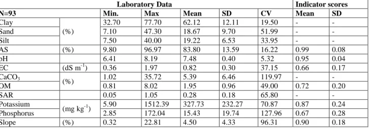
Consistent and accurate assessment of soil quality requires a reliable method to interpret and measure soil properties. Since individual soil indicator may not reflect the functioning ability of soils under different land uses (Mukherjee & Lal, 2014), assessment of soil quality can be performed by characterization of soil properties, determining the minimum data set (MDS) and calculating the soil quality index (SQI) for a given region or land use type (Andrews et al., 2004). Redundancy in data set is reduced using principal component analysis (PCA) in defining a MDS (Andrews et al., 2002; Govaerts et al., 2006; Rezaei et al., 2006). The MDS is defined as the smallest number of soil attributes which are needed to define basic soil functions i.e., resistance and resilience
to physical degradation, water and nutrient supply for plants and other living organisms in soil, and supporting plant growth (Rezaei et al., 2006). SQI can be obtained by integrating the soil properties within MDS into a single index which is a three-step process: (i) indicator selection, (ii) indicator interpretation and scoring and (iii) integration of individual indicator scores into SQI (Andrews et al., 2002).
Irrigation investments financed by the Turkish state in the Tigris basin are about to be completed, though contemporary studies on soil resources are not sufficient to support future management decisions to maintain the sustainability of agricultural production. Unfortunately, improper management decision in Harran Plain, the first largest (160.000 ha) irrigation project in the southeastern Turkey resulted in severe decline in soil fertility (Günal et al., 2015). The impact of management decisions on functioning ability of soils can be monitored and the decisions can be evaluated in a reasonable manner by soil quality assessments. The objectives of this study were to characterize variability of some physical and chemical properties of soils under different land uses, and to develop a soil quality index of different land use types in Tigris basin of upper Mesopotamian for establishing a benchmark for the upcoming soil quality evaluations in the same area.
2. MATERIALS AND METHODS 2.1. Study Area
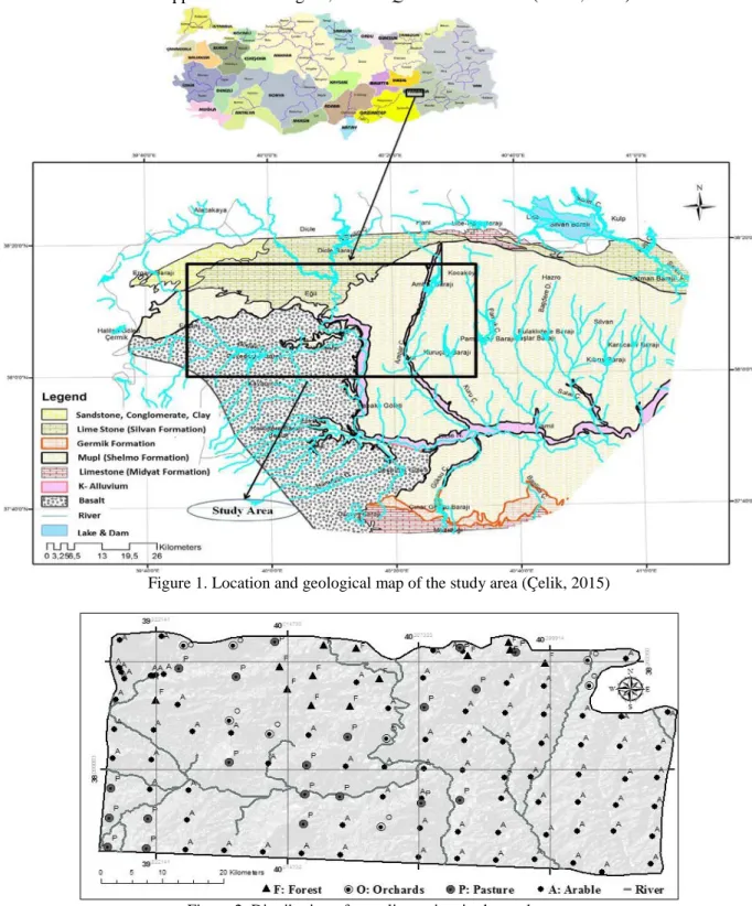
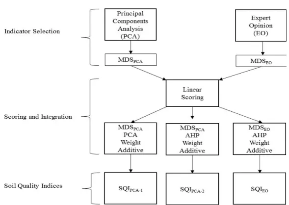
134 soil samples representing pasture lands (20), forests (13), orchards (8) and arable cultivated lands (93) were collected from an area of about 2.450 km2 located in upper Tigris Basin (between latitude 37°97' N and 38°29' N; longitude 39°75' E and 40°54' E), southeast Anatolia Region of Turkey (Figure 1). Study area was divided into 5km*5km size grids and soil samples were collected from 0-20 cm depth of the corners. The study area is located between the southeastern Taurus Mountains forming the northern and western borders and the Karacadag forming the south and south-western borders. The altitude ranges from 621 m to 1241 m. The study area is highly fragmented by rivers and deformed by tectonism. The south and southwest parts of the study area consist of flat areas covered by Karacadağ basalts. The lowlands located in the vicinity of the Karacadağ foothills are highly stony. Andisols are found in the vicinity of Karacadağ hillslopes. Entisols, Inceptisols and Vertisols are the commonly encountered soil ordos of the study area. The clay content of soils formed on Karacadağ basalts is quite high (average 66%) and smectite is the predominant clay mineral (Uzun, 2013).
Mediterranean/dry-summer subtropical climate. The total annual average rainfall of the area 474,90 mm and mean air temperature is 15.8°C (1970-2011) (Çelik & Toprak, 2016).
Crop production of arable lands at the time of soil sampling was dominated by cereals, especially wheat (Triticum aestivum L.), barley (Hordeum
vulgare L.), corn (Zea Mays L.) and lentil (Lens culinaris). Minimum or no-till systems does not
invert the soil and keep the crop residues at the surface are almost not applied in the region, and
conventional tillage with the use of rotary plough which invert soil is commonly practiced in crop production. Orchards were dominated by vineyards and followed by apple, apricot and cherry plantations. Farmers intensively tilled soils for weed management and moldboard is used in tillage operations. In forests of the study area, Quercus
infectoria is especially common among the oak
species. There are also locally distributed species such as Quercus brantii, Quercus libani and
Quercus cedrorum (Sozer, 1984).
Figure 1. Location and geological map of the study area (Çelik, 2015)
Soils in study area formed over various geological roots. Basalt is dominated on majority of the south and south-western part of the study area. The entire eastern and the upper part of the Ergani district formed over the Upper Miocene–Pliocene Şelmo formation. The Şelmo formation is alluvial in nature and is composed mainly of clay, silt, sandstone, gravel and marl bands. In addition, the Silvan formation rich in limestone is located in the north and the Mardin formation rich in limestone is located on the north of the study area (Figure 1) (Çelik, 2015). Old and new alluviums at Quaternary age deposited by the Tigris River and its tributaries over this formation (Doğan, 2005). Another highly common formation of study area is Germik which is divided into two separate sections as limestone and evaporite members. The Gemlik formation is divided into five facies which are; 1.) brown yellow colored, porous limestone facies, 2.) cream-beige colored dolomitic limestone facies, 3.) cream-beige colored gypsiferous limestone facies, 4.) gray colored gypsum, clayey gypsum facies and 5.) pink-beige colored muddy gypsum facies (Yeşilova & Helvacı, 2011).
2.2. Laboratory Analysis
Physical and chemical soil properties were measured using standard laboratory methods. Particle size distribution was determined by the hydrometer method in a sedimentation cylinder, using sodium hexamethaphosphate as the dispersing agent (Gee et al., 1986). The soil reaction (pH) and electrical conductivity (EC) were measured in a saturated paste (Rhoades, 1982). In pH measurements, an electrode of pH meter calibrated with standard solutions at pH 3, 7 and 10. CaCO3 was determined by using calcimeter
method as mentioned by Allison et al., (1965). Organic matter (OM) was determined using the technique described by Walkley and Black (1934). Organic carbon was converted to soil organic matter content multiplying by the conversion factor of 1.72 (Nelson & Sommer, 1982). Aggregate stability (AS) was determined wet sieving method (Eijkelkamp 08. 13, Netherlands). Plant available phosphorus content was analyzed by the modified Olsen’s method (Olsen & Sommers, 1982), available potassium was determined by atomic absorption spectrophotometer after extraction using 1M ammonium acetate at pH 7.0 (Thomas, 1982). Sodium adsorption ratio (SAR) was calculated from saturated paste extracts of Na+, Ca++ and Mg++ in milliequivalents per liter (U.S. Salinity Lab. Staff, 1954). The slope of each sampling point was obtained from the digital elevation model (DEM) of the study area. In order to produce DEM, SRTM digital elevation data with a resolution of 90 m was
used.
2.3. Assessment of Soil Quality
Soil quality assessment is a three-step process that is composed of determination of indicators for MDSs, scoring of indicators selected or indicator interpretation and integration of individual indicator scores into the soil quality index (Andrews et al., 2004).
2.4. Determination of Indicators
For each of land use type in study area, two different MDSs were determined by means of principal component analyses (PCA) and expert opinion (EO). In order to reduce the number of indicators while minimizing the loss of information to assess soil quality index and represent the highest variability of the original data set, PCA was performed using SPSS (version 21.0) for nine attributes. For the data set of each land use type, principal components (PC) with high eigenvalues (≥1.0) (Kaiser, 1960) were considered the best representatives explaining the variability of the original data. Varimax rotation was employed for the retained PCs to maximize the correlations between PC and the soil properties by distributing the variance (Waswa et al., 2013). Under each PC with eigenvalues ≥1.0, variable with the highest loading value and the variables within the 10% of the highest loading value were selected as soil quality indicators. The higher factor loading is considered a greater contribution to the variability in particular PC (Andrews et al., 2002; Govaerts et al., 2006; Askari & Holden, 2015). In some cases, more than one variable from each PC fitted to the indicator selection criteria, thus the redundancy among variables were analyzed by multivariate correlation. If the correlation of variables is higher than 0.60, then variable with the highest correlation sum was retained as soil quality indicator, otherwise both were retained within the MDS (Andrews & Carroll, 2001; Lin et al., 2017).
The expert opinion (EO) approach allows to select easily determined soil characteristics into the MDS. If the expert who knows the soils in the study area, crops in rotation and management practices applied on the land determines the indicators to be used, soil quality assessment will be more reliable and meaningful (Andrews et al., 2002).
2.5. Scoring the Soil Quality Indicators
The data obtained for the indicators were transformed into the unitless values ranging from 0 to 1 using linear scoring curves (Liebig et al., 2001).
Three types of scoring curves were used in transformations which are “more is better” (Fig. 3a), “less is better” (Fig. 3b) and “mid-point is optimum” (Fig. 3c). ‘More is better’ is used for positive slopes as in organic matter and aggregate stability. Masto et al., (2008b) reported that the validity of a soil quality index primarily associated to the appropriate critical limits (threshold values) used for individual soil properties. Threshold values used in calculation of indicator scores were gathered from the published literature (Table 1). Following the decision of the shape for the expected response, each indicator value was divided by the threshold value such that the value equal or higher than the threshold received a score of 1.0. For ‘less is better’, the threshold value was divided by each data value such that the data equal or lower than the threshold value received a score of 1.0. For indicators like pH, EC and CaCO3
“mid is optimum” threshold values are taken into
consideration for indicator score calculations.
2.6. Integration into a Soil Quality Index
The summary of SQI calculation is presented in Figure 4. The SQI for each sampling point was calculated using the weighted additive approach. The weightages of indicators selected in MDS obtained by PCA and EO were calculated using the PCA and analytical hierarchy process (AHP) techniques. In PCA approach; each PC with an eigenvalue ≥ 1.0 explained certain amount of variation in the total data set, and this variation was divided by the total variation of the PCs with an eigenvalue ≥ 1.0 (Andrews et al., 2002). Analytical hierarchy process is a technique that developed to organize and analyze complex decisions based on mathematics and psychology (Saaty, 2008).
Table 1. Indicators list and threshold values used in scoring
Indicators Threshold value Scoring Curve Reference
pH 5.5-7.2 Optimum is better Mukherjee & Lal, 2014
EC 0.2-0.5 dS m-1 Optimum is better Mukherjee & Lal, 2014 SAR <3.0 Less is better Mutlu, 2015
OM 2.50 % More is better Lima et al., 2013 CaCO3 4.0-8.0 % Optimum is better Mutlu, 2015
Potassium 200 mg kg-1 More is better Andrews et al., 2004 Phosphorus 15-60 mg kg-1 Optimum is better Andrews et al., 2004 AS > 60.0 % More is better Andrews et al., 2004 Slope < 6.0 % Less is better Kosmas et al., 1999
The AHP method is used to calculate weighting factors by help of a preference matrix where all identified relevant criteria are compared against each other with reproducible preference factors (Mohammed & Mohd, 2014). The weights of soil quality indicators in the AHP were primarily based on experts’ opinion or experience on soils studied and the type of land use considered.
Scored soil indicators were multiplied by the weightage of indicator in MDS and all weighted indicator scores were integrated into a single index value for each of sampling point (Eq. 1) (Andrews et al., 2002).
SQI= ∑𝑖𝑛=0𝑊𝑖𝑆𝑖 (Eq.1)
where W is the weightage of soil indicator derived from the PCA or AHP and S is the indicator score obtained by linear scoring curve. The higher SQI value indicates better functioning of a soil.
2.7. Statistical Analyses
All the data were tested for normality and equal variance prior to the statistical analyses and were transformed if needed. The differences in soil properties, soil quality indicators and SQI values among land use types were statistically analyzed by one-way analysis of variance (ANOVA) using SPSS 21.0. The PCA and related tests were also conducted using SPSS software.
3. RESULTS AND DISCUSSIONS
Twelve soil properties (Table 2) were determined as indicators for functioning capacity of soils. Since components of soil texture are inherent characteristics, they were not included into the soil quality indicator data set.
3.1. Arable Lands in Upper Tigris Basin
Descriptive statistics of indicators and scores for arable lands are presented Table 2. Arable lands were characterized by a lower soil OM content than other land uses. The highest coefficient of variation (CV) (127.96%) is occurred for the P content in arable lands. The variability of CaCO3 is very high
with 119.97% of CV. Although the mean CaCO3
content is not high (5.39%) and in some areas very low (1.02%), it reaches to 35.72% depending on the parent material of the soils. Soils are mostly heavy clayey with a mean clay content of 62.12%.
The soils of Tigris Basin, in south eastern Turkey, have a historical importance in Turkish agricultural productivity and have been subjected to intensive agricultural production and danger to decline quality of soils. In order to select soil attributes to best represent the soil quality of arable lands in upper Tigris Basin, the PCA reduced the total data set to four PCs that explained 64.43% of the total variance of the original data (Table 3).
Table 2. Descriptive statistics of soil properties used for soil quality assessment of arable lands in upper Tigris Basin.
Laboratory Data Indicator scores
N=93 Min. Max Mean SD CV Mean SD
Clay (%) 32.70 77.70 62.12 12.11 19.50 - - Sand 7.10 47.30 18.67 9.70 51.99 - - Silt 7.50 40.00 19.22 6.53 33.95 - - AS (%) 9.80 96.97 83.80 13.59 16.22 0.99 0.08 pH 6.41 8.19 7.48 0.40 5.32 0.95 0.04 EC (dS m-1) 0.36 1.97 0.82 0.30 37.15 0.66 0.17 CaCO3 (%) 1.02 35.72 5.39 6.46 119.97 - - OM 0.81 8.02 1.95 0.96 49.00 0.72 0.20 SAR 0.05 1.05 0.28 0.18 65.80 - - Potassium (mg kg-1) 5.90 1512.39 327.73 232.27 70.87 0.87 0.24 Phosphorus 2.85 172.04 15.43 19.74 127.96 0.67 0.28 Slope (%) 0.32 22.81 4.50 4.33 96.31 0.90 0.18
*SD: Standard Deviation; CV: Coefficient of variation
Table 3. Principal components and properties selected for the minimum dataset (MDS) for arable lands.
PC1 PC2 PC3 PC4 Eigen Values 1.87 1.66 1.17 1.10 % Variance 20.82 18.45 12.94 12.22 Cumulative Variance 20.82 39.27 52.21 64.43 Phosphorus 0.884 0.258 -0.055 -0.048 OM 0.881 -0.236 -0.069 0.013 Slope 0.049 -0.760 0.118 0.114 EC 0.083 0.656 0.185 0.120 AS -0.186 -0.109 0.766 0.180 CaCO3 -0.017 -0.173 -0.684 0.420 SAR 0.350 0.319 0.476 0.403 Potassium 0.012 0.125 0.014 -0.665 pH -0.038 0.436 0.067 0.637
Boldface loadings were considered highly weighted and underlined loadings were retained in MDS from the PCs after correlation analysis.
The soil parameter with the greatest loading value and the other parameters had a loading value within the 10% of the greatest loading value were selected considered for minimum data set (MDS) in each of the PCs. Organic matter and P were highly weighted variables from PC1, but were significantly correlated (r=0.62) to each other (Table 4). Plant available P was selected to MDS due to the its higher correlation coefficient sum, thus OM did not contribute to the SQI of arable lands because of high correlation with P. Slope from PC2, AS and CaCO3
from PC3 and K and pH from PC4 were highly
weighted and considered for the MDS of the arable lands in upper Tigris Basin (Table 3).
The PCA method has been preferred to establish MDS in soil quality assessments (Andrews et al., 2002; Govaerts et al., 2006; Lima et al., 2013; Mukherjee & Lal, 2014; Askari & Holden, 2015; Cherubin et al., 2016; Lin et al., 2017) due to being a less subjective method of soil quality indicator selection. Although the PCA can help to assess unbiased soil quality and to remove the redundancy in data set, the indicators considered for MDS may not be as important or meaningful as the indicators excluded from data set.
Table 4. Correlation matrix for the dataset of arable lands
pH EC CaCO3 OM AS SAR Potassium Phosphorus Slope Sum of Corr.
pH 1.00 3.04 EC 0.17 1.00 3.24 CaCO3 0.05 -0.07 1.00 2.76 OM -0.06 -0.15 0.06 1.00 3.24 AS 0.08 0.11 -0.21 -0.11 1.00 2.94 SAR 0.36 0.26 -0.15 0.12 0.16 1.00 3.40 Potassium -0.12 -0.04 -0.07 -0.03 -0.07 -0.05 1.00 2.40 Phosphorus 0.02 0.26 -0.02 0.62 -0.17 0.25 0.02 1.00 3.50 Slope -0.19 -0.19 0.13 0.08 0.03 -0.06 0.02 -0.14 1.00 2.83
Cherubin et al., (2016) indicated that a large number of indicators are needed to run the PCA which is not convenient to adopt for farm or regional scale soil quality assessments. The soil quality indicator list for the regional scale soil quality assessment of arable lands in Tigris Basin based on common decisions of the authors (expert opinion, EO), and land use types comprised of slope, P, AS, pH, EC and OM.
Organic matter or organic carbon is the most commonly used indicator of soil quality for various types of soils around the world particularly for the arid and semi-arid regions (Vasu et al., 2016; Raiesi, 2017). Organic matter stores and supplies nutrient and water for soil organisms and plants, improves resistance to degradation through holding soil particles together and reducing the negative impact of erosion and prevents to form undesired physical conditions such as compaction and surface crust. Therefore, organic matter was considered as one of the soil quality indicators in this study, and included into the MDS by EO for the assessment of soil quality of arable lands. Soil pH is an important soil quality indicator due to the significant effect on solubility and availability of plant nutritions. Nutrients are found either as cation or anion forms in soils and bound to charged surfaces called anion or cation exchange sites of soils. The status of hydrogen ions bound to the charged surface or free in soil solution largely determines the charge of the soil particles and availability of nutrients (McCauley et al., 2009).
The phosphorus is frequently deficient (˂4.5 mg kg-1 in 58% of the country) in alkaline soils of Turkey (Eyüpoğlu, 1999), thus the P indicator is important to present the P supply potential of soils to plant growth, and therefore included into the MDS of arable lands and orchards by EO. Plant available P is considered one of the major plant nutrients and also a primary factor limiting yields due to its weak mobility, thus Liu et al., (2017) used P for soil diagnosis and fertility
assessment of Camellia oleifera grown soils in mid-subtropical China. The phosphorus was scored by a mid-point optimum approach. The left side of the P scoring curve reflects the P concentration for crop requirements, and the right side express the hazardous impact of excess P such as P runoff to surface water (Andrews et al., 2004).
Potassium is an essential plant nutrient for plant growth and considered one of the soil quality indicators of arable lands with PCA, however soils in Turkey as well as the Tigris basin contain adequate amount of K, thus not included to the MDS by EO.
3.2. Pasture Lands in Upper Tigris Basin
Descriptive statistics of indicators and scores for pasture lands are presented Table 5. Soil properties belonged to different land use types were presented in separate tables.
Four PCs were identified with eigenvalue ≥1.0 for pasture lands and explained 75.0% of the total variance of the data set (Table 6). The first PC explained 26.59% of the total variance and pH and EC were highly weighted variables within 10% of the highest factor loading value (Table 6). The correlation between pH and EC (r=0.57) was less than 0.60, thus both included into the MDS (Table 7). Plant available potassium, AS and P had the highest factor loadings from PC2, PC3 and PC4, respectively. The indicators considered for MDS had low correlations between each other and the MDS of pasture lands in upper Tigris basin were thus comprised of pH, EC, K, AS and P. However, the expert opinion for the soil quality indicators of pasture lands MDS was consisted of AS, EC, OM and slope.
3.3. Orchards in Upper Tigris Basin
Descriptive statistics of indicators and scores for orchards are presented Table 8. Orchards in study
Table 5. Descriptive statistics of soil properties used for soil quality assessment of pasture lands in Upper Tigris Basin.
N=20 Laboratory Data Indicator Scores
Min. Max. Mean SD CV Mean SD
Clay (%) 26.45 77.70 60.70 11.28 18.58 - - Sand 4.80 52.10 15.24 10.85 71.22 - - Silt 17.50 35.00 24.06 4.97 20.65 - - AS (%) 48.72 98.11 80.33 11.86 14.76 1.00 0.01 pH 6.67 7.90 7.22 0.33 4.60 0.98 0.03 EC (dS m-1) 0.38 1.15 0.75 0.20 26.32 0.70 0.17 CaCO3 (%) 1.31 27.96 4.92 6.94 141.19 - - OM 0.80 5.14 2.71 1.18 43.69 0.85 0.21 SAR 0.05 0.45 0.18 0.12 66.39 - - Potassium (mg kg-1) 85.53 723.59 325.15 189.94 58.42 0.90 0.19 Phosphorus 2.52 49.90 15.05 15.22 101.14 0.62 0.33 Slope (%) 0.90 17.62 5.24 4.85 92.51 0.88 0.22
Table 6. Principal components and properties selected for the minimum dataset (MDS) for pasture lands. PC1 PC2 PC3 PC4 Eigen values 2.39 1.79 1.444 1.127 % Variance 26.59 19.84 16.05 12.52 Cumulative Variance 26.59 46.43 62.48 75.00 pH 0.867 -0.004 -0.054 0.284 EC 0.832 -0.074 0.178 -0.394 SAR 0.608 0.316 0.531 0.079 CaCO3 0.457 0.125 -0.081 -0.251 Potassium -0.061 0.858 0.094 -0.007 Slope 0.299 0.734 -0.327 0.044 AS 0.053 -0.189 0.900 -0.189 Phosphorus 0.014 -0.063 -0.277 0.863 OM -0.258 0.331 0.467 0.625
Boldface loadings were considered highly weighted and underlined loadings were retained in MDS from the PCs after correlation analysis.
Table 7. Correlation matrix for the dataset of pasture lands
area were mainly vineyard (5 of 8 orchards) and mixed fruits (apple, cherry and apricot) and moldboard plow has been used in soil tillage. The OM content was significantly lower compared to the other land uses due to the intensive tillage operations. Although soils in orchards have high clay content (58.33%), it was slightly lower than the soils of other land use types. Aggregate stability similar to OM is one of the key indicators of soil quality, and low AS is considered to be a sign of degradation of soils. The positive influence of OM and clay content on stability of aggregates have been
documented (Muneer & Oades, 1989; Šimansky & Jonczak, 2016). The lower OM and clay contents of orchard soils along with the lower AS values compared to the land uses support the interaction of OM and clay content with AS.
The PCA indicated three PCs with eigenvalues ≥1.0 for orchards of upper Tigris Basin, and these three PCs explained 82.16% of the variance of the data set. The PC1 explained 41.03% of the variance and P had the highest factor loading value.
Table 8. Descriptive statistics of soil properties used for soil quality assessment of orchards in Upper Tigris Basin.
Laboratory Data Indicator Scores
N=8 Min. Max Mean SD CV Mean SD
Clay (%) 45.20 75.20 58.33 9.91 16.99 - - Sand 4.80 27.10 15.61 6.78 43.45 - - Silt 17.70 35.00 26.06 6.44 24.70 - - AS (%) 42.81 89.42 73.70 15.76 21.39 0.98 0.05 pH 6.61 7.85 7.19 0.42 5.81 0.98 0.03 EC. (dS m-1) 0.55 0.91 0.73 0.13 17.94 0.70 0.13 CaCO3 (%) 1.22 33.59 10.95 13.48 123.11 0.73 0.63 OM 1.10 2.82 1.87 0.57 30.39 0.73 0.20 SAR 0.05 0.45 0.18 0.14 77.87 - - Potassium (mg kg-1) 71.03 591.23 285.16 191.26 67.07 - - Phosphorus 3.89 132.72 27.62 43.06 155.9 0.60 0.32 Slope (%) 1.42 8.53 4.67 2.51 53.83 0.96 0.10
*SD: Standard Deviation; CV: Coefficient of variation
pH EC CaCO3 OM AS SAR Potassium Phosphorus Slope Sum of Corr.
pH 1.00 3.80 EC 0.57 1.00 4.64 CaCO3 0.12 0.41 1.00 3.09 OM -0.09 -0.36 -0.12 1.00 3.55 AS -0.04 0.28 0.04 0.23 1.00 3.71 SAR 0.46 0.48 0.16 0.12 0.33 1.00 4.08 Potassium -0.04 -0.07 0.03 0.18 -0.09 0.31 1.00 3.11 Phosphorus 0.16 -0.35 -0.02 0.30 -0.36 -0.08 0.03 1.00 3.32 Slope 0.32 0.12 0.17 0.15 -0.35 0.15 0.37 -0.02 1.00 3.64
Table 9. Principal components and properties selected for the minimum dataset (MDS) for orchards. PC1 PC2 PC3 Eigen values 3.69 2.04 18.42 % Variance 41.03 22.72 15.58 Cumulative Variance 41.03 63.74 82.16 Phosphorus 0.935 0.199 0.058 Slope 0.841 -0.471 -0.063 CaCO3 0.743 0.073 -0.463 SAR -0.033 0.940 0.279 pH 0.056 0.925 -0.096 AS -0.166 0.144 0.764 OM -0.291 0.392 -0.753 EC -0.287 0.530 0.696 Potassium -0.503 0.251 0.584
Boldface loadings were considered highly weighted and underlined loadings were retained in MDS from the PCs after correlation analysis.
The slope had a factor loading value within 10.0% of the highest factor loading value (Table 9). The correlation analyses revealed that P and slope were significantly correlated (r>0.60), thus the P having the highest correlation sum (slope) was selected for the MDS (Andrews and Carroll, 2001; Lin et al., 2017). SAR and pH were the highly weighted variables from PC2 and considered for MDS. These two variables explained 22.72% of the variance. SAR was selected from PC2 for MDS due to the higher correlation coefficients sum compared to that of pH (Table 10). Organic matter had the highest factor loading value from PC3 and factor loading values of OM and EC were within the 10.0% of the highest factor loading.
The correlation analyses revealed that correlation coefficient of OM with AS and EC was low, therefore included into the MDS. But, AS and EC were significantly correlated to each other (r=0.68), EC was considered for MDS due to its higher correlation coefficient than AS. Similarly, EC and SAR had significant correlation (r=0.71) and EC had a greater correlation coefficient sum than SAR (Table 10), thus included in the MDS (Table 9). The AS and SAR did not contribute to the SQI of orchards due to the high correlations with EC.
Therefore, the final MDSPCA of orchards in upper
Tigris Basin was comprised of slope, OM and EC. The researchers’ opinion (MDSEO) on the indicators
to be used in regional scale soil quality assessment of orchards is substantially different from MDSPCA.
The salinity is not a limiting factor in the pasture lands of the upper Tigris basin, thus excluded from the MDS, instead pH, plant available P, CaCO3 and
AS were included to the MDS.
3.4. Forest Lands in Upper Tigris Basin
Descriptive statistics of indicators and scores for forest land are presented Table 11. Although clay content did not differ among land uses, clay content (64.05%) of forest land was slightly higher compared to other land use types (Table 11). The lowest mean sand, CaCO3, K and P contents were
obtained in forest land soils, whereas clay, silt and OM contents were comparable higher than the soils of other land uses.
The first four PCs had eigenvalues ≥1.0 and explained 81.16% of the variance of the data set (Table 12). The highly weighted variables under PC1 were EC and OM, and they were significantly correlated (r=0.62) to each other (Table 13).
Table 10. Correlation matrix for the dataset of orchards
pH EC CaCO3 OM AS SAR Potassium Phosphorus Slope Sum of Corr.
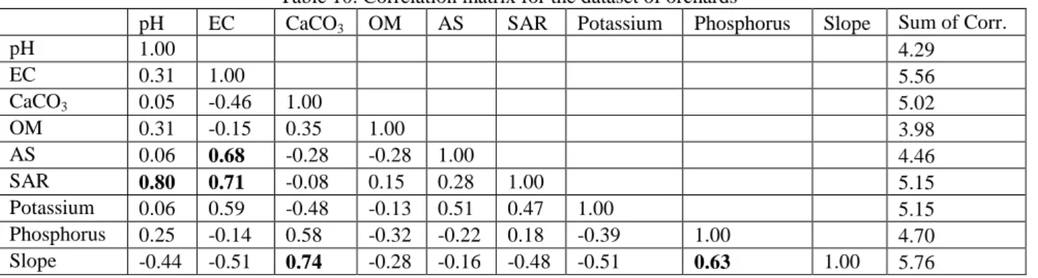
pH 1.00 4.29 EC 0.31 1.00 5.56 CaCO3 0.05 -0.46 1.00 5.02 OM 0.31 -0.15 0.35 1.00 3.98 AS 0.06 0.68 -0.28 -0.28 1.00 4.46 SAR 0.80 0.71 -0.08 0.15 0.28 1.00 5.15 Potassium 0.06 0.59 -0.48 -0.13 0.51 0.47 1.00 5.15 Phosphorus 0.25 -0.14 0.58 -0.32 -0.22 0.18 -0.39 1.00 4.70 Slope -0.44 -0.51 0.74 -0.28 -0.16 -0.48 -0.51 0.63 1.00 5.76
Table 11. Descriptive statistics of soil properties used for soil quality assessment of forest lands in Upper Tigris Basin.
Laboratory Data Indicator Scores
N=13 Min. Max. Mean SD CV Mean SD
Clay (%) 45.20 75.20 64.05 7.88 12.30 - - Sand 4.80 22.30 9.23 4.71 51.01 - - Silt 17.50 32.70 26.73 3.98 14.90 - - AS (%) 44.57 94.33 81.01 12.83 15.84 0.99 0.03 pH 6.67 7.81 7.22 0.43 5.89 - - EC (dS m-1) 0.39 0.93 0.54 0.14 26.96 - - CaCO3 (%) 1.07 31.91 4.64 8.38 180.71 - - OM 3.06 6.73 3.68 1.00 27.24 1.00 0.00 SAR 0.07 1.43 0.32 0.36 113.03 1.00 0.00 Potassium (mg kg-1) 41.04 282.27 101.62 66.69 65.62 0.98 0.06 Phosphorus 2.90 59.90 22.10 18.74 84.85 - - Slope (%) 2.17 22.83 7.72 5.51 71.36 0.81 0.25
*SD: Standard Deviation; CV: Coefficient of variation
Table 12. Principal components and properties selected for the minimum dataset (MDS) for forest lands.
PC1 PC2 PC3 PC4 Eigen values 2.88 2.11 1.24 1.08 % Variance 32.04 23.40 15.68 11.96 Cumulative Variance 32.04 55.45 69.20 81.16 EC 0.883 0.047 -0.005 -0.108 OM 0.852 -0.011 0.210 0.226 Phosphorus 0.790 0.241 -0.091 0.034 CaCO3 -0.113 -0.957 0.063 -0.023 AS 0.159 0.880 -0.138 0.249 SAR 0.007 0.030 0.912 0.022 pH 0.101 0-.371 0.763 -0.288 Slope 0-.218 0.035 0.274 -0.811 Potassium -0.116 0.354 0.088 0.781
Boldface loadings were considered highly weighted and underlined loadings were retained in MDS from the PCs after correlation analysis.
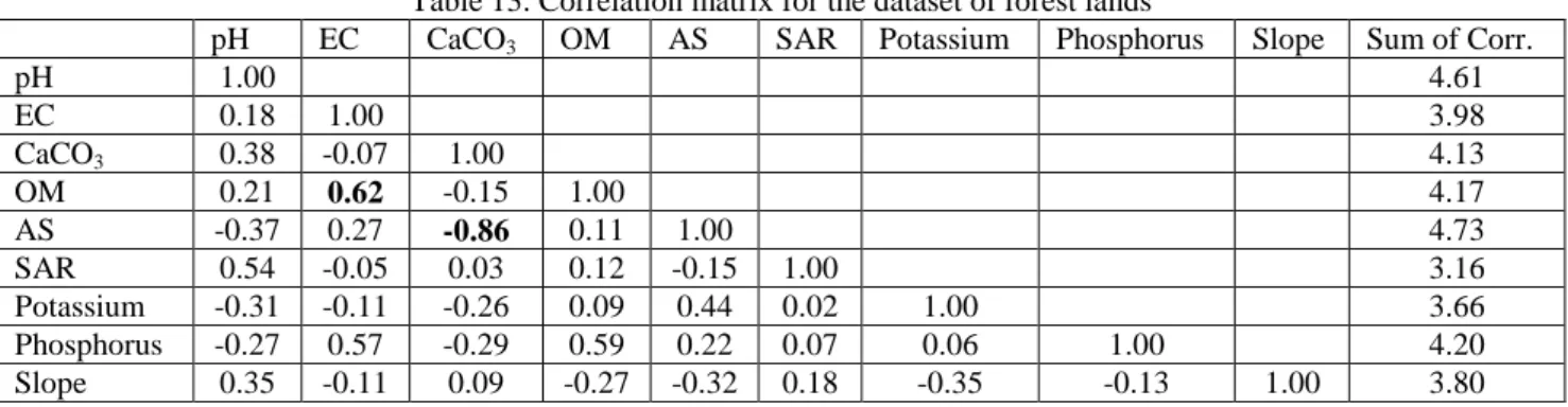
Table 13. Correlation matrix for the dataset of forest lands
pH EC CaCO3 OM AS SAR Potassium Phosphorus Slope Sum of Corr.
pH 1.00 4.61 EC 0.18 1.00 3.98 CaCO3 0.38 -0.07 1.00 4.13 OM 0.21 0.62 -0.15 1.00 4.17 AS -0.37 0.27 -0.86 0.11 1.00 4.73 SAR 0.54 -0.05 0.03 0.12 -0.15 1.00 3.16 Potassium -0.31 -0.11 -0.26 0.09 0.44 0.02 1.00 3.66 Phosphorus -0.27 0.57 -0.29 0.59 0.22 0.07 0.06 1.00 4.20 Slope 0.35 -0.11 0.09 -0.27 -0.32 0.18 -0.35 -0.13 1.00 3.80
Organic matter had the highest correlation coefficient sum and thus, was retained for the MDS. The CaCO3 and AS were highly weighted variables
from PC2 and significantly correlated (r=-0.86) to each other, AS was considered for MDS due to its higher correlation coefficient sum. Under PC3, SAR was the only highly weighted variable and selected for MDS. The slope and K were highly weighted variables from PC4 and both were retained for the MDS because they were not well correlated. The
final MDS for forest land in upper Tigris Basin were comprised of OM, AS, SAR, slope and K. The MDSEO, based on experts’ opinions was composed
of only OM, slope and AS.
3.5. Soil Quality Assessment
The mean values of pH, EC, OM, P, K, sand and silt significantly (P˂0.01) varied among four land use types evaluated. However, one way
ANOVA revealed that only pH, EC, OM and P indicator scores were significantly differed among land use types (Table 14).
The indicator lists and the weights used to calculate final SQI of four land uses were presented in Table 15. The PCA and EO revealed that different set of indicators would be required for soil quality assessment of each land use. However, the OM along with slope and AS are considered as the most important and common indicators by the EO to assess and monitor the soil quality of four land uses in upper Tigris basin. The weights of indicators revealed the
potential contribution rate of indicators in soil quality assessment. The indicator of OM was given the highest weightage for all land uses by the researchers due to the significant contribution to ability of soils to form stable aggregates, adsorb and release nutrients and water on its surface which sustain and support plant growth and biodiversity in soils (Seybold et al., 1997; Brejda et al., 2000).
In MDSPCA of orchards, slope had the highest
weightage (0.526) while OM had the greatest contribution (0.339) to SQI in MDSEO. Due to the
significant influence on soil quality affecting water retention, formation of stable aggregates, lowering bulk density, buffering soil pH, increasing cation exchange capacity providing suitable surfaces for pesticide adsorption and heavy metals, enhancing infiltration, aeration and creating habitat for soil biota (Seybold et al., 1997), Brejda et al., (2000) reported that total organic carbon of soils alone could be used to monitor soil quality.
In the SQIEO where the weightages of
indicators were determined by AHP, the contribution of pH, OM, EC and slope to overall SQI of arable lands was 25.2%, 22.4%, 20.0% and 17.4%, respectively (Table 15). The OM indicator in forest land, similar to pasture and orchards, had the highest weightage (0.668) suggested that OM may be considered the primary constraint limiting the functioning potential of soils in these land uses.
Table 15. The weightages of soil quality indicators for minimum data sets (MDS) selected by principal component analyses (PCA) and expert opinion (EO)
PCA MDS EO MDS
Land Use PCA weight AHP weight AHP weight
Arable Lands P 0.271 0.099 P 0.072 Slope 0.241 0.259 Slope 0.174 AS 0.169 0.139 AS 0.077 pH 0.159 0.449 pH 0.252 K 0.159 0.054 EC 0.200 OM 0.224 Pasture Land AS 0.158 0.476 AS 0.102 EC 0.262 0.196 EC 0.127 pH 0.262 0.194 OM 0.519 K 0.195 0.051 Slope 0.253 P 0.123 0.085 Orchards Slope 0.526 0.285 Slope 0.112 OM 0.237 0.577 OM 0.339 EC 0.237 0.139 pH 0.255 P 0.103 CaCO3 0.097 AS 0.095 Forest Land OM 0.344 0.488 OM 0,668 AS 0.251 0.113 AS 0.157 Slope 0.128 0.238 Slope 0.175 SAR 0.148 0.118 K 0.128 0.044 Table 14. Results of one-way analysis of variance
(ANOVA) for different land uses in terms of soil attributes
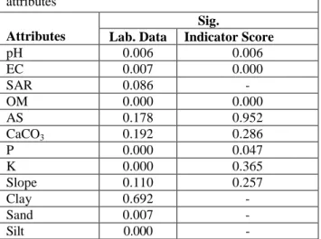
Attributes
Sig.
Lab. Data Indicator Score
pH 0.006 0.006 EC 0.007 0.000 SAR 0.086 - OM 0.000 0.000 AS 0.178 0.952 CaCO3 0.192 0.286 P 0.000 0.047 K 0.000 0.365 Slope 0.110 0.257 Clay 0.692 - Sand 0.007 - Silt 0.000 -
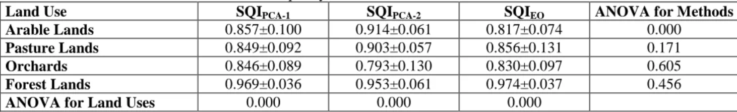
Table 16. Soil quality index values for different land uses
Land Use SQIPCA-1 SQIPCA-2 SQIEO ANOVA for Methods
Arable Lands 0.857±0.100 0.914±0.061 0.817±0.074 0.000
Pasture Lands 0.849±0.092 0.903±0.057 0.856±0.131 0.171
Orchards 0.846±0.089 0.793±0.130 0.830±0.097 0.605
Forest Lands 0.969±0.036 0.953±0.061 0.974±0.037 0.456
ANOVA for Land Uses 0.000 0.000 0.000
Three different SQI values were calculated as SQIPCA-1, SQIPCA-2 and SQIEO. The SQIPCA-1 is
calculated by multiplying the scores of indicators determined by PCA with the weightages obtained by PCA. The SQIPCA-2 is calculated by multiplying the
scores of indicators determined by PCA with the weightages obtained by AHP. The SQIEO is calculated
by multiplying the scores of indicators determined by EO with the weightages obtained by AHP. The SQI values of four land uses were significantly different at P˂0.01 for each of the three different methods. The methods only yielded a significantly different result for arable lands and SQI values were not different from each other for the other three land uses. The SQI values were significantly (P≤0.01) higher in the following order for SQIPCA-1 and SQIPCA-2: Forest Lands ˃ Arable
Lands ˃ Pasture Lands ˃ Orchards, and for SQIEO:
Forest Lands ˃ Pasture Lands ˃ Orchards ˃ Arable Lands, indicating that land use type has a significant effect on soil quality. The highest SQI value was obtained for forest land with EO (SQIEO=0.974) and
the lowest SQI value was for orchards with PCA (SQIAHP=0.793). The significant difference in SQI
among land use types is resulted from the difference in indicators selected for the MDS to compute the SQI and the weightages obtained by PCA and AHP. Brejda et al., (2000) explained that variation of soil quality between soil and geographic regions is a consequence of the differences in major soil forming factors such as parent material, climate, vegetation and topography and anthropogenic factors such as land use practices in each region.
In the orchards, conventional tillage with the use of moldboard plow resulted in reduction of OM content due to the increased mineralization rate which promoted aggregate destruction (Bronick & Lal, 2005). In addition to the negative influence of OM loss, breaking of macro aggregates into small and less stable aggregates by tillage equipment decreased the AS of orchards which consequently lowered the functioning ability of soils.
The mean SQIPCA-1 value (0.849) of pasture
lands was slightly lower than SQIPCA-2 (0.914) and
SQIEO (0.856) of pasture, though there was no
statistical difference (P=0.171) among values of SQI (Table 16).
Spatial distribution of SQI values obtained by
three different methods were mapped and presented in Figure 5, 6 and 7, respectively. Since the SQI values of different methods were similar except for arable lands, the maps produced were also very similar to each other. The best soils are located on the northern and southeastern part of the study area, while soils with the lowest soil quality were on the south west and north-east part of the upper Tigris basin.
The SQI value of forest land was significantly higher compared to the other land uses in upper Tigris Basin. The SQIEO (0.974) was slightly higher than the
SQIPCA-1 (0.969) and SQIPCA-2 (0.953) due the
indicators in MDS and the weightages of indicators. The forest lands were mostly located in sloppy areas (mean slope 7.72%) of northern part of the study area (Figure 5, 6 and 7) and less affected by the anthropogenic impacts. The fallen litters of the trees increased the organic matter content of the surface soils in forest lands and sustained the high soil quality despite the slope. High OM content of soils in forest land increased the AS and resulted in higher SQI values among the land uses in upper Tigris basin.
4. CONCLUSIONS
Soil quality indicators for four land use types in upper Tigris Basin were determined by PCA and EO and used in calculation of SQI to learn how soil quality of soils changed by different land uses. The SQI values of lands uses were significantly differed from each other. The difference in SQI values was mainly due to the changes in indicators used and the weights of each indicator because of the differences in land use types. Soil organic matter, AS and slope were considered to be the key indicators of MDSs determined by EO for the soil quality assessment of all four land uses, these indicators significantly affected the computed SQI values. Since OM is the key element of soil fertility and fulfills an important role in sustaining productivity, it had the highest weightages in land uses (except arable lands) with AHP technique. However, the data reduction technique, PCA, used to determine MDS revealed some differences in indicator lists which resulted in significant differences in SQI values of arable lands (P˂0.01) and forest lands (P˂0.05).
The SQI values for pasture and orchard lands obtained with three methods were significantly
similar to each other. The similarity in spatial patterns of the soil quality indicators and SQI values confirm the applicability of the methods in
assessment of soil quality in Tigris Basin as well as the regions which have similar characteristics.
Figure 5. Spatial distribution of SQIPCA-1 values in upper Tigris basin
Figure 6. Spatial distribution of SQIPCA-2 values in upper Tigris basin
Acknowledgement
This research was funded by The Scientific and Research Council of Turkey (TUBITAK) with a grant number of TOVAG 214O374.
REFERENCES
Allison, L. E, Bollen, W. B. & Moodie, C. D., 1965. Total
carbon. Methods of soil analysis. Part 2. Chemical and microbiological properties methods of soil: 1346-1366.
Çelik, R., & Toprak, Z. F., 2016. The Effects of Global
Climate Change On The Groundwater Level In Diyarbakir City Center VIII. National Hydrology Congress. 7(2) P: 283
Andrews, S. S. & Carroll, C. R., 2001. Designing a soil
quality assessment tool for sustainable agroecosystem management. Ecological Applications, 11(6), 1573-1585.
Andrews, S. S., Karlen, D. L. & Mitchell, J. P., 2002. A
comparison of soil quality indexing methods for vegetable production systems in Northern California. Agriculture, ecosystems & environment, 90(1), 25-45.
Andrews, S. S., Karlen, D. L. & Cambardella, C. A.
2004. The soil management assessment framework. Soil Science Society of America Journal, 68(6), 1945-1962.
Askari, M. S. & Holden, N. M., 2015. Indices for
quantitative evaluation of soil quality under grassland management. Geoderma, 230, 131-142.
Brejda, J. J., Moorman, T. B., Karlen, D. L. & Dao, T. H., 2000. Identification of regional soil quality
factors and indicators I. Central and Southern High Plains. Soil Science Society of America Journal, 64(6), 2115-2124.
Bronick, C. J. & Lal, R., 2005. Soil structure and
management: a review. Geoderma, 124(1), 3-22.
Cherubin, M. R., Karlen, D. L., Cerri, C. E., Franco, A. L., Tormena, C. A., Davies, C. A. & Cerri, C. C.,
2016. Soil quality indexing strategies for evaluating sugarcane expansion in Brazil. PloS one, 11(3), e0150860.
Çelik, R., 2015. Temporal changes in the groundwater
level in the Upper Tigris Basin, Turkey, determined by a GIS technique. Journal of African Earth Sciences. 107 P: 134–143
Doğan, U., 2005. Land subsidence and caprock dolines
caused by subsurface gypsum dissolution and the effect of subsidence on the fluvial system in the Upper Tigris Basin (between Bismil–Batman, Turkey). Geomorphology, 71(3), 389-401.
Evans, G., 2011. An historical review of the Quaternary
sedimentology of the Gulf (Arabian/Persian Gulf) and its geological impact. In: Kendall, C.G.S., Alsharhan, A. (Eds.), Quaternary Carbonate and Evaporite Sedimentary Facies and Their Ancient Analogues: A Tribute to D.J. Shearman International Association of Sedimentologists,
Special Publication 43. Wiley-Blackwell, Chichester, pp. 11–44.
Eyüpoğlu, F., 1999. Fertility status of Turkish soils. Soil
Fertilizer Research Institute. General Publications No: 220, Ankara, Turkey (in Turkish).
Gee, G. W., Bauder, J. W. & Klute, A., 1986.
Particle-Size Analysis, Methods of Soil Analysis, Part 1. Physical and Mineralogical Methods, Soil Since Society of America. Inc., Madison, WIS, USA.
Govaerts, B., Sayre, K. D. & Deckers, J., 2006. A
minimum data set for soil quality assessment of wheat and maize cropping in the highlands of Mexico. Soil and Tillage Research, 87(2), 163-174.
Günal, H., Korucu, T., Birkas, M., Özgöz, E. & Halbac-Cotoara-Zamfir, R., 2015. Threats to sustainability
of soil functions in Central and Southeast Europe. Sustainability, 7(2), 2161-2188.
Kaiser, H. F., 1960. The application of electronic
computers to factor analysis. Educational and Psychological Measurement, 20, 141-151.
Karlen, D.L., Ditzler, C.A. & Andrews, S.S., 2003. Soil
quality: why and how? Geoderma 114, 145–156.
Karlen, D. L., Hurley, E. G., Andrews, S. S., Cambardella, C. A., Meek, D. W., Duffy, M. D. & Mallarino, A. P., 2006. Crop rotation effects on
soil quality at three northern corn/soybean belt locations. Agronomy journal, 98(3), 484-495.
Kosmas, C., Kirkby, M. J. & Geeson, N., (Eds.) 1999.
The Medalus Project: Mediterranean Desertification and Land Use: Manual on Key Indicators of Desertification and Mapping Environmentally Sensitive Areas to Desertification. Directorate-General Science, Research and Development.
Liebig, M. A., Varvel, G. & Doran, J., 2001. A simple
performance-based index for assessing multiple agroecosystem functions. Agronomy Journal, 93(2), 313-318.
Lima, A. C. R., Brussaard, L., Totola, M. R., Hoogmoed, W. B. & De Goede, R. G. M., 2013. A
functional evaluation of three indicator sets for assessing soil quality. Applied Soil Ecology, 64, 194-200.
Lin, Y., Deng, H., Du, K., Li, J., Lin, H., Chen, C. & Zhang, G., 2017. Soil quality assessment in
different climate zones of China’s Wenchuan earthquake affected region. Soil and Tillage Research, 165, 315-324.
Liu, J., Wu, L., Chen, D., Li, M. & Wei, C., 2017. Soil
quality assessment of different Camellia oleifera stands in mid-subtropical China. Applied Soil Ecology, 113, 29-35.
Marzaioli, R., Ascoli, R. D., De Pascale, R. A. & Rutigliano, F. A., 2010. Soil quality in a
Mediterranean area of Southern Italy as related to different land use types. Appl. Soil Ecol. 44, 205– 212.
Masto, R. E., Chhonkar, P. K., Singh, D. & Patra, A. K., 2008a. Alternative soil quality indices for
evaluating the effect of intensive cropping, fertilisation and manuring for 31 years in the
semi-arid soils of India. Environmental monitoring and assessment, 136(1-3), 419-435.
Masto, R.E., Chhonkar, P.K., Purakayastha, T.J., Patra, A.K. & Singh, D., 2008b. Soil quality
indices for evaluation of long-term land use and soil management practices in semi-arid sub-tropical India. Land Degrad. Dev. 19, 516–529.
McCauley, A. Jones, C. & Jacobsen, J., 2009. Soil pH
and organic matter. Nutrient management module, 8, 1-12.
Mohammad, S.N. & Mohd M.A., 2014. Land Suitability
Analysis for Sustainable Agricultural and Use Planning in Bulandshahr District of Uttar Pradesh. Int. J. Scientific Res. Publications,4(3):1-11.
Mukherjee, A. & Lal, R., 2014. Comparison of soil
quality index using three methods. PloS one, 9(8), e105981.
Muneer, M. & Oades, J. M., 1989. The role of Ca-organic
interactions in soil aggregate stability. II. Field studies with 14C-labeled straw, CaCO3 and CaSO4. 2. H2O. Soil Research, 27(2), 401-409.
Mutlu, N., 2015. Assessment of Desertification Indicators
In A Semi-Arid Region for Monitoring And Mapping. Gaziosmanpasa University. Institute of Science. Department of Soil Science and Plant Nutrition. Doctorate Thesis. P: 61-63.
Nelson, D.W. & Sommer. L.E., 1982. Total carbon,
organic carbon, and organic matter. In A.L. Page (ed.) Methods of Soil Analysis. 2nd Ed. ASA Monogr. 9(2). Amer. Soc. Agron. Madison, P: 539-579.
Olsen, S. R. & Sommers, L. E., 1982. Phosphorus,” in
Methods of soil analysis, Part 2: Chemical and Microbiological Properties, A. L. Page, Ed. Madison, WI, USA: ASA-SSSA, pp. 403-430.
Raiesi, F., 2017. A minimum data set and soil quality
index to quantify the effect of land use conversion on soil quality and degradation in native rangelands of upland arid and semiarid regions. Ecological Indicators, 75, 307-320.
Rezaei, S. A., Gilkes, R. J. & Andrews, S. S., 2006. A
minimum data set for assessing soil quality in rangelands. Geoderma, 136(1), 229-234.
Rezaei, H., Jafarzadeh, A., Aliasgharzad, N. & Alipoor, L.,
2015. Soil quality investigation based on biological and micromorphological traits under different land uses. Carpathian Journal of Earth and Environmental Sciences, 10(1), 249-262.
Rhoades, J.D., 1982. Soluble salts. In: A.L. Page et al.(ed.)
Methods of soil analysis: Part2. Agronomy Monogr. 9. 2nded. ASA and SSSA, Madison, WI. P: 167-178
Saaty, T. L., 2008. Decision making with the analytic
hierarchy process. International journal of services sciences, 1(1), 83-98.
Šimansky, V. & Jonczak, J., 2016. Water-stable
aggregates as a key element in the stabilization of soil organic matter in the Chernozems. Carpathian journal of earth and environmental sciences, 11(2), 511-517.
Seybold, C. A., Mausbach, M. J., Karlen, D. L. & Rogers, H. H., 1997. Quantification of soil quality.
Soil processes and the carbon cycle, 387-404.
Sozer, A. N., 1984. A Geographical Perspective on the
Natural Environment Conditions of Southeastern Anatolia. Journal of Aegean Geography, 2(1), 8-30. (in Turkish).
Yeşilova, Ç., Helvacı, C. 2011. Stratigraphy and
sedimentology north of Batman and Siirt, Turkey. Bulletin of Turkish Association of Petroleum Geologists. 23:2, 7-49.
Thomas, G. W., 1982. Exchangeable cations. In Methods
of soil analysis, part 2. Chemical and microbiological properties, 2nd edn, Page AL, Miller RH, Keeney DR (eds). ASASSSA No. 9: Madison, Wisconsin, USA; 159–165.
U.S. Salinity Laboratory Staff. 1954. Diagnosis and
improvement of saline and alkali soils. In L.A. Richards (ed.) USDA Handb. 60. USDA, Washington, DC.
Uzun, C. 2013. Determination of decomposition rates of
soils formed on volcanic material at different ages. PhD Dissertation, Selçuk University. Institute of Science and Technology. YOK Dissertation No: 346419. Konya, Turkey.
Vasu, D., Singh, S. K., Ray, S. K., Duraisami, V. P., Tiwary, P., Chandran, P. & Anantwar, S. G.,
2016. Soil quality index (SQI) as a tool to evaluate crop productivity in semi-arid Deccan plateau, India. Geoderma, 282, 70-79.
Veum, K. S., Sudduth, K. A., Kremer, R. J. & Kitchen, N., 2017. Sensor data fusion for soil health
assessment. Geoderma 305:53-61.
Walkley, A., & Black, I. A. 1934. An examination of
the Degtjareff method for determining soil organic matter, and a proposed modification of the chromic acid titration method. Soil science, 37(1), 29-38.
Waswa, B. S., Vlek, P. L., Tamene, L. D., Okoth, P., Mbakaya, D. & Zingore, S., 2013. Evaluating
indicators of land degradation in smallholder farming systems of western Kenya. Geoderma, 195, 192-200.
Received at: 04. 07. 2017 Revised at: 12. 09. 2017
Accepted for publication at: 07. 10. 2017 Published online at: 12. 10. 2017