3 (2), 2009, 161 - 164
©BEYKENT UNIVERSITY
Hydrogeochemical Modelling System: A Case Study
of Gümüşhaciköy (Amasya, TURKEY) Aquifer
*
Arzu FIRAT ERSOY and Hakan ERSOY
Karadeniz Technical University, Department of Geological Engineering, 61080, Trabzon, TURKEY
arzufirat@gmail. com
Received: 25.06.2009, Revised: 08.07.2009, Accepted: 20.11.2009
'Corresponding Author
Abstract
Approximately 10 different systems of classification of natural water types were developed (Matthess, 1982). Stuyfzand Classification System combines excellent features of existing classifications with new, strongly diagnostic criteria for subdivision. And this classification plays very important role for determination of hydrogeochemical evolution of groundwater plain.
The location plain is important because of it has very huge amount of water in the Gümüşhacıköy Aquifer. This water is used for the industrial purposes and agricultural area in the plain. In this study hydrochemical evolution of Gümüşhacıköy Plain was determined using Stuyfzand Classification System and totally 79 well water, 37 well water analysis results between 1951 and 1972, and 42 well water analysis results between 2003 and 2004, were compared with each other considering this classification system. According to this classification system, the sequence concludes that freshening is going on
from NaHCO3+ to MgHCO3+. The south and southwest of the plain is formed
CaHCO3f water type according to the first analyses results but CaHCO3+
water type dominates the consequence of freshening to the second analyses results. Typical freshening is going on from west to east in time and the
composition of the groundwater is turned into CaHCO3+ water type.
Keywords: Stuyfzand Classification System, Hydrogeochemistry, Gümüşhacıköy Aquifer
Özet
Doğada, su tiplerini belirlemek amacıyla geliştirilen yaklaşık 10 farklı sınıflama sistemi bulunmaktadır (Matthess, 1982). Mevcut sınıflama sistemlerinin bir kombinasyonu olan Stuyfzand Sınıflama Sistemi, yeraltısuyu ortamının hidrojeokimyasal gelişimini belirlemede önemli bir rol
Hydrogeochemical Modeling System: A Case Study of Gumu^hacikoy (Amasya, TURKEY) Aquifer
Çalışma alanının önemi, Gümüşhacıköy Akiferi'nin yüksek miktarda yeraltısuyuna sahip olmasından dolayıdır. Bu yeraltısuyu çalışma alanında endüstriyel amaçlar için ve tarımda sulama amacı ile kullanılmaktadır. Merzifon-Gümüşhacıköy Havzası sınırları içerisinde yer alan Gümüşhacıköy Akiferi'nin hidrojeokimyasal evrimini belirlemek amacıyla akiferde bulunan toplam 79 sondaj kuyusunda yapılan su kimyası analiz sonuçları değerlendirilmiş ve yeraltısuyu kimyasal gelişimi ortaya konmuştur. Akiferde yapılan yeraltısuyu örneklemesi 1951-1972 yılları arasını kapsayan 37 örnek ve 2003-2004 yıllarını kapsayan 42 örnekten oluşmaktadır. Çalışmanın sonucunda her iki örnekleme sonucunda geliştirilen hidrojeokimyasal model, Stuyfzand Sınıflama Sistemi'ne göre karşılaştırılarak yeraltısuyunun karakteristikleri ve hidrojeokimyasal gelişimi belirlenmiştir. Buna göre
akiferde yıkanma NaHCO3+'dan MgHCO3+'ya doğru devam etmektedir.
Gümüşhacıköy Akiferi'nin güney ve güneybatı kesimleri 1951-1972 yılları
analiz sonuçlarına göre CaHCO3f su tipinden oluşurken 2003-2004 yılları
analiz sonuçlarına göre CaHCO3+ su tipindedir. Bir başka deyişle, ikinci analiz
sonuçları yıkanma işleminin devam ettiğini göstermektedir. Stuyfzand Sınıflama Sistemi'nde açıklanan yıkanma işleminin Gümüşhacıköy Akiferi'nde batıdan doğuya doğru devam ettiği ve yeraltısuyu bileşiminin
CaHCO3+ su tipine doğru değiştiği belirlenmiştir.
Anahtar Sözcükler: Stuyfzand Sınıflama Sistemi, Hidrojeokimya, Gümüşhacıköy Akiferi.
Introduction
Classification systems are common tools within resources management and are used in a wide range of roles. This is also true for groundwater, as a review of groundwater classification systems developed or in use in Turkey jurisdictions revealed. There is currently no generic groundwater classification model that can be followed, hence classification systems are developed specific either to the objectives and needs of the jurisdiction or to characterize the technical aspects of the resource [1]. In developing the classification system a number of factors had to be considered. It need to be efficient and cost-effective and take advantage of existing water well and water chemistry data sources without requiring expensive drilling and sampling programs [1]. One need of the groundwater quality research as applied to groundwater is to have a clear understanding of the groundwater background quality reference, or baseline, in order for it to be compared to the current situation [2].
Although the history of geologic and hydrogeologic investigations in the Gümüşhacıköy Plain dates back to 1893, the first detailed report named "Hydrogeologic Report of the Artesian Wells in the Merzifon-Gümüşhacıköy Plain" was prepared by Dr. Recep Egemen in 1955 [3].
According to the study named "Brief Information about the Merzifon-Gümüşhacıköy Groundwater" carried out by Tufan Subaşı in 1967, discharge
of the artesian wells was calculated as 5,2x10⁶ m3/year and detailed hydro
geologic studies were suggested [4].
The report named "Irrigation from groundwater of the Merzifon-Gümüşhacıköy Plain" was prepared by the State Hydraulic Works in 1973 (Altuğ and Ertuğrul 1973) [5]. According to this report groundwater reservoir
was calculated as 25x106 m3/year and the report indicates that 4600 hectares
with 15 l/sec - 160 wells could be irrigated.
General Properties of the Study Area
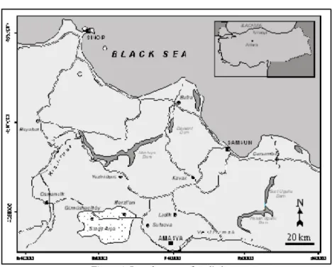
Gümüşhacıköy Plain is located in the western part of the Amasya City. The plain is about 35 km far from Amasya City. The plain covers an area of about
300 km2, and recharge area of the Gümüşhacıköy Plain is 1060 km2. The plain
is a generally flat area with low rolling hills in the eastern part of Gümüşhacıköy. Groundwater is supplied to wells and springs by two principal aquifers. The tuff, tuffite, agglomerate and volcanic lava differ from sand, clay and gravel in topographical shape. The neogene field was eroded by the river and flood waters and as a result it turned out to have a wavy structure. The volcanic field has a more flat shape with respect to neogene (Figure 1).
The drainage system in the plain is affected by the tectonically structure. The main rivers in the plain are Gümüşsuyu River, Köseler River and İmirler River. Dry climate conditions are dominant in the plain. Based on the data of the Merzifon Meteorological Station for the period of 1965-2005, the average
annual precipitation is 417 mm, while the average temperature is 11,33 0C [6].
The main industries in the region are sugar-beet processing, sunflower processing, textile, wood products. Agricultural activities in the town are quite intensive. The crops grown in the plain are grains, sugar-beet, sunflower, onion, potato, poppy, maize, vegetable and fruit. Totally 167 wells are situated in the Gümüşhacıköy Aquifer at the present time. These wells have been used for domestic and industrial purposes in the villages of the Gümüşhacıköy, irrigation water in the aquifer [7].
Hydrogeochemical Modeling System: A Case Study of Gumu^hacikoy (Amasya, TURKEY) Aquifer
Figure 1. Location map of studied area
Geologic Setting
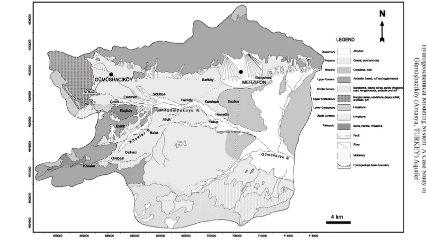
In the area studied, the Paleozoic metamorphic suit is the oldest formation. This unit consists of clayey schist, chlorite schist, and green schist, marble and recrystallized limestone. The jurassic limestone, with fossils which are generally compact and overlie uncomfortably metamorphic suit in the plain are situated in the area. Lower Cretaceous limestone, pinky colored, very hard, recristallized and much fissured, overlies Jurassic limestone. Upper Cretaceous limestone outcrops on the high altitudes in the plain. This series with mixed volcanic material composed of conglomerate, green and black sandstone, shale, marl, limestone, andesite, tuff and tuffite are deposited in the Upper Cretaceous. Senozoic started with the Middle Eocene flysich in the study area. Flysich consists of sandstone, shale, sandy limestone, marl, locally conglomerate, tuff and agglomerate. Catchments area was filled with continental material of 1000-1500 m thickness affected by east-west elongated faults in the Neogene. These thick series consist of Miocene blue clay and marl on the lower part; Pliocene sand, clay, gravel and a mixture of these on the upper part. The layer thickness ranges from 10 to 50 cm in these series. The quaternary is characterized by the alluvium and the alluvium cone consisting of detrical material that comes from north and south with the flood waters. Alluvium and cone, of 10-60 m thickness and take form gravel, sand, clay and
mixture of these, form along the Gümüşsuyu River, Köseler River, ímirler River and Salhan River. Geological map of the study area is shown in Figure2.
Hydrogeology
The most important units for groundwater transport in Gümüşhacıköy Plain are Quaternary alluvium and Pliocene clay, sand, gravel and mixture of these. It is seen that the distinguishing of Pliocene series and Quaternary alluvium are very challenging when the drilling cores in the plain are observed for these two units have same lithologic features. The plio-quaternary aquifer is unconfined at high altitudes in the north and west, but confined at low altitudes.Because the area between north and west of the area has not contained impervious layer Gümüşhacıköy Aquifer is determinate as unconfined aquifer in this area. But in the east part of the plain it is observed that an impermeable clay layer 2-10 m in thickness situated on the plio-quaternary aquifer. Thickness of this clay layer is increased from middle to west part of the plain.
The thickness of Plio-Quaternary loose material ranges from 20 to 150 m in this area. The aquifer around Gümüşhacıköy consists of gravel of great size, clay and clayey gravel and its thickness ranges from 50 to 350 m. Groundwater flow direction is from northwest to southeast in the Imirler Valley, from southwest to northeast in the Köseler Valley and from west to east in the Gümüşsuyu Valley.
Groundwater recharge in the Gümüşhacıköy Plain is through the infiltration of precipitation and influent surface water (Gümüş River and Köseler River) and irrigation channels. Domestic wastewaters of the town infiltrate into the aquifer and contaminate the groundwater.
to
to
Gravel, earid and clay Claystorie, mail
AndeaKa, basalt, tuff and agglomerate mart, konglomerats, andezite and tuff Istana,clayey seiltet,
Motorway Hydrogeologie basin boundary
Hydrogeochemistry
The first hydrogeologic studies were begun by the State Hydraulic Works in 1951 in Merzifon-Gümüşhacıköy plain and have continued today. The well waters of the Gümüşhacıköy Plain have been used for municipal, industrial and irrigation purposes. Totally 167 water wells have been drilled in the Gümüşhacıköy Plain. 154 wells of these wells have been used for irrigation and industrial purposes, 13 of these have been employed for drinking water. During the first phase of the study, in July 2003, 37 wells have been drilled between 1951-1972 were identified and hydrogeologic and hydrogeochemical data were collected. 42 wells have been drilled after 1972 were studied in August 2004 in the second phase and same analyses were repeated. Stuyfzand Classification System was operated using with first hydrogeochemical analysis results and hydrochemical evolution of the Gümüşhacıköy Aquifer System was determinated. Make use of the second analysis results Stuyfzand Classification System was defined again and two classification results relating to the hydrogeochemical evolution of the aquifer was performed.
The depth of the wells range between 50 m (minimum) and 290 m (maximum), discharge rates between 5 and 60 l/sec. Presently, new wells are still being drilled and operated by the State Hydraulic Works, as the water requirements of the city constantly increase. Moreover, private owners around the city also operate a number of groundwater wells.
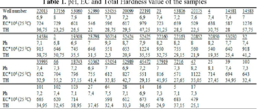
The pH values of all samples are range between 6,8 and 9,9. EC values are change between 439-1276 mS/cm. Total hardness values of the samples are range between 2,5-57,75 according to the French Hardness and change between "very soft" and "very hard" water types. pH, EC and TH values are shown in Table 1 chemical analysis results are shown in Table 2.
Table 1. pH, EC and Total Hardness value of the samples
Well number 22013 17156 53060 52990 53055 20099 22191 23 53806 20175 4 14531 14533 Ph 6,9 S 7.9 8 7.3 7.2 6.9 7.4 7.2 7.6 7.4 7.4 7 E Csi as( 2 5 ° C ) 724 729 601 546 596 617 979 723 659 509 633 537 1276 TH 36,7: 23,25 26,5 22 28,75 29,5 47,25 31,25 23,5 22,5 30,75 23 57,75 14584 2 19308 28798 30714 52424 52425 22160 22163 20852 20850 53030 32 Ph 7.1 6.8 6.9 7 9,9 3.7 7.9 3.2 3.2 3 3.2 7.7 7.4 E C " 1 0 » { 2 5 ° Q 915 646 745 646 551 653 1224 950 755 560 540 640 918 TH 3S,75 30,75 35,5 31,5 2,5 20,9 35,55 32,75 29,15 21,9 19,35 25,4 41,2 33995 66 18743 50362 53054 52989 45472 57919 7216 47 25 39 100 Ph 7.4 7.3 7.2 6,9 7 6.9 7.2 7 7.3 3.2 3.1 7.4 7.3 E C * i as( 2 5 ° C ) 632 704 796 755 612 327 551 816 571 1122 714 694 643 TH 32,9 35,2 37,15 41,4 33,35 42,7 29,15 41,95 27,65 35,05 27,45 34,95 32,4 101 102 103 27 64 28 14 16 5 17 Ph 7.2 7.4 7.1 7.4 7.5 7.1 6.9 7.3 7.1 7.3 E C,l Dt( 2 5 « Q 665 620 714 598 612 673 476 633 479 TH 34,95 32,45 38,95 37,45 32,4 33,9 36,65 24,9 37,15 25,1
Hydrogeochemical Modeling System: A Case Study of Gumu^hacikoy (Amasya, TURKEY) Aquifer Table 2. Chemical analysis results of the water samples
Well n u m b e r 2 2 0 1 3 17156 5 3 0 6 0 5 2 9 9 0 53055 2 0 0 9 9 2 2 1 9 1 23 53S06 2 0 1 7 5 4 145 SI 145 S3 Ca"L 9 1 2 3S.1 6 9 . 1 5S.1 7 7 2 S 2 2 133.3 7 9 2 " 3 . 1 63.1 S3 2 S 4 2 14". 3 M e t5 34 21.3 2 2 . 5 1 S 2 23.1 21.9 34 2 8 24.9 16.4 24.3 17 51.1 X V 2 9 . 9 6 9 . 9 2 9 . 9 2 6 . 9 1 16.1 17.04 2S.9S 34.96 2S,9S 23 11.96 14;03 4 2 . 0 9 K" 1.91 2 3 4 1.56 1,56 0,7 S 1.56 3.12 1.56 1.: 1.17 1.56 1.: 5,07 HCOj" 3~3 247.5 2 2 5 3 : 0 245 245 3S5 2 7 0 2 7 5 2 2 0 2S2.5 2 2 0 445 CI" 11.4 19.9 21.3 15,6 19.9 12.S 4 4 9 . 9 I S ,5 11.4 9 . 9 4 9 . 9 6 0 . 4 S O / 109,4 107,5 " 3 , 9 39.4 4S.5 6 S 2 ss.s 1 0 2 2 4 6 . 6 3S.9 37.4 74.9 139." X H , " 0 0 0 0 0 0 0,05 0.1 o.i 5 O.i 5 0,05 0 . 4 0,05 NOj- 0 0 0 0 0 0 0 0 0 0 0 0 0 NOä" 4.63 3.03 5.36 2 9 3 5,07 4 . 9 6 1.313 5.54 3.23 5.1" 2.62 5,SS 15.61 143 84 J 1930S 2 8 - 9 8 30 14 5 2 4 2 4 52425 2 2 1 6 0 22163 2 0 8 5 2 2 0 8 5 0 53031) 32 Ca"; S 9 2 92.S 1 0 4 2 S S 2 4 36 57 50 75 54 47 55 100 M e t5 4 0 . 1 19.5 2 3 . 1 23.1 3.6 2 S . 6 51.1 4S.6 2 4 . 9 2 0 . 1 1 8 2 2S 3S,9 X V 4 2 . 0 9 13.11 19.09 11.04 106.3 59.11 126.04 6 9 , 9 2 4 1 . S 6 2 9 . 9 3".3 31.05 4 9 . 9 1 K" 3.12 6 2 4 2 3 4 6.63 0,7 S 1.95 3.51 1.17 1.95 1.56 3.51 1.95 1,56 H C O i 3 2 » 275 2 9 7 . 5 307,5 21.5 2 7 5 340 352,5 2 5 7 , 5 2 4 5 2 5 0 2 2 7 , 5 33".5 a 32.7 12,8 21.3 11.4 1S.5 1 4 2 35 J 4S.3 15.6 IS,5 1 4 2 11.4 1 4 2 so,- 112.3 4 9 6 9 2 23 14.9 41.S 231.4 55,7 99.S 13 " 2 75 ,S 156.5 X H , " 0 0 0 0 0.3 O.i 0.1 O.i 0 , 0 5 0,05 0,05 0.2 0,05 NOj- 0 0 0 0 0 0.001 0.001 0.004 0.004 0 0 0 0 NOj- 10.69 4.05 7.74 3,S5 0 0.1 ".3 6,75 3.35 3,05 3.35 3.4 4.55 3 3 » 3 66 1 8 - 4 3 50362 5 3 0 5 4 529S9 4 5 4 - 2 5 - 9 1 9 • 2 1 6 4 _ 25 39 IOO Ca"; S6 "S 9 7 112 104 110 S4 89 " 3 55 48 SI 77 MB"5 27.4 37,7 31 3 2 2 1S.S 3 6 . 5 19,5 41.3 2 2 . 5 51.1 37.1 35,3 31.6 X V 17.94 23.92 4 1 . S 6 23 13.11 39.1 13.11 22.0S 17.94 101.S9 4 9 . 9 1 2 3 . 9 2 2S.9S K- 1.36 1.95 1.95 1.17 0.7 S 1.17 1.17 1.95 1.17 1.95 1.95 2 . " 3 5.46 HCOj" 307,5 345 302.5 377,5 257,5 3 1 0 232.5 325 235 3S5 2 5 0 3 2 0 375 CI" 1 1 4 9 , 9 1 4 2 " . 1 1S.5 17 24. i 15.6 2 5 . 6 53.3 21.3 9 , 9 9 , 9 S O / 4 3 2 4 3 . " 135.4 " 3 . 4 S 0 2 170.4 51.4 116.2 42.7 107 9 9 . 4 6 6 2 3.4 X H , " 0 0 0 0,05 0 0 0 0,05 0 , 0 5 0,5 0,05 0.2 0 NQJ- 0 0 0.03 0.001 0 , 0 0 2 0 0 0 0 , 0 0 2 0 0 , 0 0 2 0 0 NOj" 2,7 4,75 6,7 4,95 9,3 6 2 5 9 3 ".35 6:35 4.65 l . S 1.05 11)1 102 103 2) 6 4 2S 14 16 5 1 / Ca'L j 1 6 2 9 3 SS SO 9 0 101 6 4 9 2 " 3 MB"5 41.3 40.7 37,7 3 " . l 29.S 2 7 . 4 2 7 . 4 21.3 34 16.4 X V 14.53 13.1 19.09 11.96 13.11 14.03 23 14.03 16:1 13.11 K" 5,07 5.46 3.12 0,7 S 1.17 1.56 0,7 S 0.7 S 1 _ 17 0,7 S HCOj" 372,5 340 4 0 0 372,5 33".5 3 1 0 307,5 195 3 2 0 2 2 5 ci- " . 1 8,5 8,5 " . 1 8,5 21.3 11.4 8,5 8,5 11.4 S O / 5.S 2 0 2 16.3 2 . 9 2S.S SS.S 69.1 "1.5 37 X H , " 0 0 0 0 0.1 0 O.i 0,05 0 0 N O j " 0 0 0 0 0 0 . 0 0 4 0.001 0 . 0 0 1 0 0,001 NOj" 0,95 3,25 0 . 0 5 2 3 0.65 2.3 5,9 4 5,5 5;1
Stuyfzand Classification System
The hydrochemical classification system combines the superior features of existing classifications with the new. The first version [8] had been improved specifically for groundwater in coastal, calcareous sand aquifer systems with cat ion exchange phenomena due to fresh or salt water intrusion. The second version [9] has been enlarged for non-calcareous systems. Therefore, this classification can be applied to water in any hydro geologic systems.
Determination of a water type depends upon the determination of the main type, subtype and class of the water sample. This hierarchical structure is shown in Table 3.
Table 3. The hierarchical structure of the classification system, with four levels of subdivision. The number of subdivisions within types, subtypes and classes is merely a
theoretical maximum, because many combinations do not occur in nature (Stuyfzand.1986)
Name Subdivisions Criteria Cades
Main Type 6 Cl F. Fb. B. Bs, S. H
Type 11 Total Hardness x. 0. 1. 2. 3.4. 5. 6. 1. 8. 9
Subtype 16 Most important anicn-cation NaCl. NaS&j. NaHCO;. NaMix. KNOj, NH,S04
CaCl, CaS04, CaNOj. CaHC03, CaMix, MgCl,
MgHCOä, MgMix, AISO4. FeSOj
Class 3 (Na+K+Mg) corrected
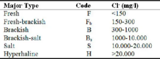
Each of four levels of subdivision contributes to the total code of the water type, as indicated in Table 3. Chloride content indicates the main type. There
are 6 different main types; fresh (F), fresh-brackish (Fb), brackish (B),
brackish-salt (Bs), salt (S) and hyperhaline (H) (Table 4).
Table 4. Determination of the first symbol for water type according to the Cl—content (Stuyfzand, 1986) '
M a j o r Type Code Cl (Iiis 1)
Fresh F <150 Fresh-brackish Fb 150-300 Brackish B 300-1000 Brackish-salt Bs 1000-10.000 Salt S 10.000-20.000 Hyperhaline H >20.000
Total hardness of water determines the type. Hardness of waters changes between very soft (x) and extremely hard (9) (Table 5).
Table 5. Determination of the second symbol for water type according to the total hardness (TH) (Stuyfzand, 1986) Niune Code TH (°F) Very soft X <5 Soft 0 5-10 Moderately hard 1 10-20 Hard 2 20-40 Very hard 3 40-80 Extremely hard 4 80-160 Extremely hard 5 160-320 Extremely hard 6 320-640 Extremely hard 7 640-1280 Extremely hard 8 1280-2560 Extremely hard 9 >2560
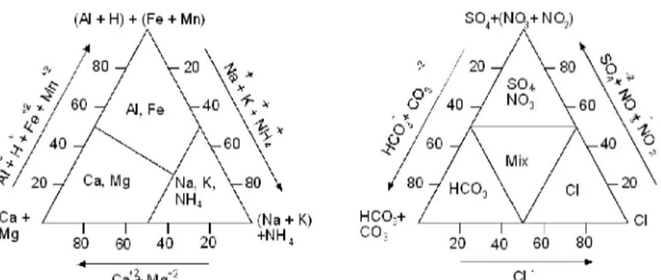
Combination of cation and anion predominate in the ion balance indicates the name of the subtype. First the strongest hydrogeochemical family is determined both for cations and anions, (Al + H + Fe + Mn) and (SO4 + NO3 +
NO2) family. Then the strongest member of both families is chosen to form the
Hydrogeochemical Modeling System: A Case Study of Gumu^hacikoy (Amasya, TURKEY) Aquifer
(Al + H) + (Fe + Mn) SO +(NQj+ NOj)
Mg 20 40 60 SO
Ca^-Mg*2 CI
Figure 3. Subdivision of types on the basis of the proportional share of main constituents in the sum of cations (left) and anions (right) in meq/l. (Stuyfzand, 1986)
Each class is divided into 3 classes according to total amount of Na+, K+ and
Mg+2 in meq/l corrected for a contribution of sea salt;
( N a + K + M g ) c o r r e c t e d = ( N a + K + M g ) m e a s u r e d - 1 , 0 6 1 C l
3 classes are found out, (Na + K + M g ^ ^ t (-), (Na + K + M g ^ ^ u m (f) and
(Na + K + Mg)surplus (+). (-) sign indicates a salt water intrusion and (+) sign
indicates fresh water encroachment (Table 6). Upon fresh water encroachment, Ca expels the formerly adsorbed Na, K and Mg ions from the exchanger. With salt water intrusion the reverse takes place.
Table 6. Determination of cation exchange code (Stuyfzand, 1986)
Name Code Condition
(Na+K+Mg)-deficit - (Na+K+Mg)con.„tEd<-(l/2 Cl)^
(Na+K+Mg)-equilibiium i|, -(1/2 Cl)1 ;<=(Na+K+Mg)concctciJ<=( 1/2 Cl)";
(Na+K+Mg)-suiplus + (Na+K+Mg)„„ctei>(l/2C1)^
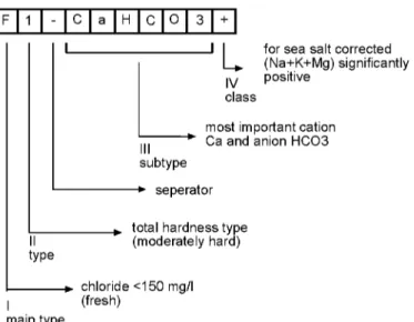
Final determination after the definig four classification parameters has been seen on Figure 4.
F 1 - C a H C O
L
for sea salt corrected(Na+K+Mg) significantly IV positive
class
most important cation Ca and anion HCO3 subtype
seperator
type
total hardness type (moderately hard)
I
chloride <150 mg/l (fresh)
main type
Figure 4. Coding and explaining of a water type in 10 positions. The example is called "a fresh, moderately hard calciumcarbonate water with a (Na + K + Mg)surplus"
(Stuyfzand, 1986)
Material and Methods
During the studies the water samples were collected from new wells and then the samples was analyzed. Water samples were collected from the wells in polyethylene bottles, and filtered through ash-free filter paper and spilt in one parts. This part was acidified with 5% nitric acid for analysis. pH and electric conductivity (EC) and were measured in the laboratory, and temperature of the waters were measured in-situ.
Major cations (Ca+2, Mg+2, Na+, K+), anions (HCO3", Cl-, SO4 ), NH4+, NO2"
and NO3- analyses of the groundwater samples were determined by titration in
State Hydraulic Works Quality Control Laboratory.
The evolution of the groundwater of the plain is renewed by employing Stuyfzand Classification System. The evolution of the groundwater was determined by employing the results of the two classification systems.
Experimental Procedure and Results
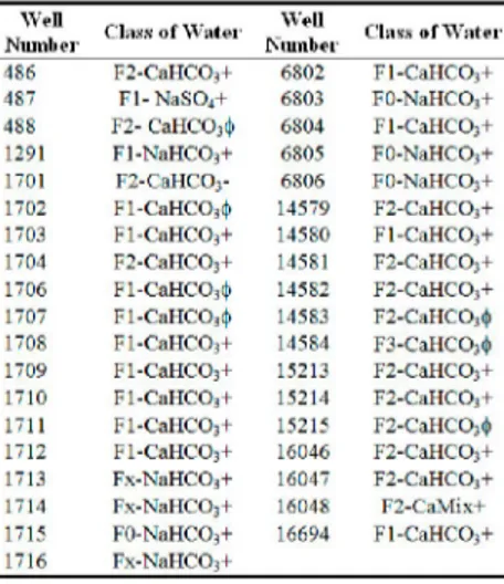
Stuyfzand Classification System According to 1951-1972 Analysis Results 1951 and 1972 anaylsis were carried out by the State Hydraulic Works in Samsun City. These results are taken from the State Hydraulic Works for this study. The evolution of the Gümüşhacıköy groundwater is determined by using Stuyfzand Classification System prepared with the analyses results between
Hydrogeochemical Modeling System: A Case Study of Gumu^hacikoy (Amasya, TURKEY) Aquifer
water sample analyses with 37 wells. According to the Cl content put as the first symbol in the classification system, the waters are classified as "fresh" main type. The second symbol in the classification is; on the other hand, "total hardness". The groundwater changes between "soft" and "very hard" to total
hardness. The water composed of CaHCO3, NaMix and CaMix is classified
into the third symbol of dominant anion-cation pairs. The groundwater is (Na
+ K + M g ) s u r p l u s and (Na + K + M g ) e q u i l i b r i u m generally, (Na + K + M g ) d e f i c i t
rarely to fourth symbol cation exchange code. Stuyfzand Classification System table and map is designed for Gümüşhacıköy groundwater by gathering these four components (Table 7) (Figure 5).
Table 7. Stuyfzand classification system of Gümüşhacıköy well waters according to 1951-1972 analyses results W e l l N l l l l l l i ' l i 1.i.... o f W a t e r W e l l N u m b e r C l a s s o f W a t e r 4 8 6 F 2 - C a H C OJ+ 6 8 0 2 F l - C a H C O j + 4 8 7 F l - N a S O j + 6 8 0 3 F O - N a H C O j + 4 8 8 F 2 - C a H C O i t j i 6 8 0 4 F l - C a H C O i + 1 2 9 1 F l - N a H C O , + 6 8 0 5 F O - N a H C OJ+ 1 7 0 1 F 2 - C a H C O;- 6 8 0 6 F O - N a H C O;+ 1 7 0 2 F l - C a H C O j i J . 1 4 5 7 9 F 2 - C a H C OJ+ 1 7 0 3 F l - C a H C O j + 1 4 5 8 0 F l - C a H C O i - F 1 7 0 4 F 2 - C a H C O = + 1 4 5 8 1 F 2 - C a H C O;+ 1 7 0 6 F l - C a H C O . i } 1 4 5 8 2 F 2 - C a H C O , + 1 7 0 7 F l - C a H C O j i ) . 1 4 5 8 3 F 2 - C a H C O j i | i 1 7 0 8 F l - C a H C O j + 1 4 5 8 4 F 3 - C a H C O ı i t ı 1 7 0 9 F l - C a H C O j + 1 5 2 1 3 F 2 - C a H C O i + 1 7 1 0 F l - C a H C O j + 1 5 2 1 4 F 2 - C a H C O j + 1 7 1 1 F l - C a H C O s + 1 5 2 1 5 F 2 - C a H C O j i t i 1 7 1 2 F l - C a H C O j + 1 6 0 4 6 F 2 - C a H C O i + 1 7 1 3 F x - N a H C O , + 1 6 0 4 7 F 2 - C a H C O j + 1 7 1 4 F x - N a H C O = + 1 6 0 4 8 F 2 - C a M i x + 1 7 1 5 F O - K a H C O , + 1 6 6 9 4 F l - C a H C O i - F 1 7 1 6 F x - N a H C O j +
It is clear from the table that there is a number of water classes in the study
area. CaHCO3+ and CaHCO3f water types are accepted as two different types;
1 and 2 hardness codes are admitted as one water class in practice. X and 0 hardness codes in NaHCO3+ waters are accepted as one water class. Therefore, the classification is more general in practice. As a result of these
FX,F0-NaHCO3+, F1,F2-CaHCO3+ and F1,F2,F3-CaHCO3f water types form the
whole plain.
In the north and northwest of the plain the type of the groundwater is
F2-CaHCO3+ as shown in Figure 5. The cation exchange occurs through the
entering of fresh water to the media,. The middle of the plain is composed of
F1-CaHCO3+, west F2-CaHCO3+ and south and southwest F2-CaHCO3f.
When thinking of the groundwater flow direction has occurred from northwest and southwest to east it has been seen that the freshening in groundwater with groundwater flow direction is became harmoniously. The groundwater is
FX,F0-NaHCO3+ water type in the east and southeast of the study area.
According to the results of Stuyfzand Classification System conducted groundwater sampling represent between 1951 and 1972 years, a typical freshening starting from west and keep going to east dominates in the Gümüşhacıköy plain.
Marine conditions absorbed by the clay surfaces are exchanged against fresh
water cations from the infiltrating water. The Na+, K+ and Mg+2 cations from
the clay surface are replaced by Ca+2 cation. This occurred rise to the genesis
of the Na+HCO3-+ and Ca+2HCO3"+ water types. After the clay has been
Hydrogeochemical Modeling System: A Case Study of Gumu^hacikoy (Amasya, TURKEY) Aquifer
There are two main groundwater types in the plain; NaHCO3 + and CaHCO3 +,
f types. From the preceding discussion it is evident that dilution is increased towards the east and the freshening is going on. Groundwater composition is changed as a result of stages of cation exchange. Fresh water is originating
from precipitation in which CaCHO3- has been dissolved.
In the plain in the west, cation exchange is in the final stage, and water is
CaHCO3 +, f type. In the south-east and east of the plain, cation exchange is in
important stage and the water is NaHCO3 + type. The reason is that the clay cover is much thinner in the east.
A typical freshening process is seen below;
Initial sea water conditions (SNaClf) dominated in the beginning of the process. Original sea water diluted gradually due to the recharge phenomena and then sea water conditions coming from S ended up F.
Dilution of sea water is; S ® B s ® B ® F b ® F
The second stage is cation exchange. Dilution stage is taken place in the solid matrix of clay minerals. Clay surfaces play exchanger role and pore water started to dilute. Typical marine cations Na, K, Mg are diluted and Ca concentration is increased. Na exchanges with Ca and Na decreases, Ca increases.
Cation exchange process is;
NaClf®NaCl+®NaHCO3+®MgHCO3+®CaHCO3+®CaHCO3f
NaHCO3+, MgHCO3+ and CaHCO3+ water types indicate typical freshening.
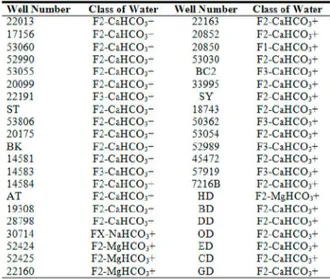
Stuyfzand Classification System According to 2003-2004 Analysis Results
From 1972 on the wells which have been drilled up so far has been used as drinking and irrigation water. Due to the increase in the number of wells the groundwater level is declined rapidly and the revision study has been started in 2002. The water samples have been collected from the new and old wells and analyzed during the revision study. 42 water analyses results are used and Stuyfzand Classification System is prepared for the plain.
All water samples are "fresh" main type according to the Cl content. The hardness of the groundwater changes between "very soft" and "very hard" with
respect to the total hardness. NaHCO3, MgHCO3 and CaHCO3 water subtypes
are dominant in the plain as to dominate anion-cation pairs. All waters are (Na
+ K + Mg)surplus compared to the cation exchange code. Finally, Stuyfzand Classification System was prepared in the form of tables and maps as shown in Table 8 and Figure 6.
Table 8. Stuyfzand classification system of Gümüşhacıköy well waters according to 2003-2004 analyses results
\ \ ell N u m b e r Class of M ater \ \ ell Number Class of AVater
22013 F 2 - C a H C 03- 22163 F 2 - C a H C 03 -17156 F 2 - C a H C 03- 20852 F 2 - C a H C 03 -53060 F 2 - C a H C 03- 20850 Fl-CaHCO^— 52990 F 2 - C a H C 03- 53030 F2-CaHCO;-53055 F 2 - C a H C 03- EC2 F3-CaHCO;-20099 F 2 - C a H C 03- 33995 F2-CaHCOj— 22191 F 3 - C a H C 03- SY F 2 - C a H C 03 -ST F2-CaHC03+ 18743 F2-CaHCO^— 53806 F2-CaHCCb- 50362 F 3 - C a H C 03 -20175 F 2 - C a H C 03- 53054 F2-CaHCO;-B K F 2 - C a H C 03- 52989 F3-CaHCO;-14581 F2-CaHCOj— 45472 F 2 C a H C O , -14583 F 3 - C a H C 03- 57919 F3-CaHCOj— 14584 F 2 - C a H C 03- 7216B F2-CaHCO^— AT F2-CaHCCb- HD F 2 - M g H C 03 -19308 F 2 - C a H C 03- BD F2-CaHCO;-28798 F 2 - C a H C 03- DD F2-CaHCO;-30714 F X - N a H C O ; - OD F 2 - C a H C 03 -52424 F 2 - M g H C O j - ED F2-CaHCOj— 52425 F2-MgHCO^- CD F2-CaHCO^— 22160 F2-MgHCO^- GD F2-CaHCO^—
According to these results as seen on Figure 6 the dominating water types of
the west of the plain are composed of F1, F2, F3-CaHCO3+ and east of the
aquifer are consisted of FX,0-NaHCO3+ water type.
Discussion And Conclusions
Stuyfzand Classification System is prepared from the results of the first analyses produced between 1951 and 1972 years. Therefore a hydrogeochemical evolution model belonging to the Gümüşhacıköy Aquifer has been determinated. According to these results F2-CaHCO3+ water types
are dominant in the north of the plain, F1-CaHCO3+ water types are dominant
in the middle of the plain, F2-CaHCO3+ water types are dominant in the west
of the plain, F2-CaHCO3f types are dominant in the southwest. Groundwater
flow direction has been occurred from northwest and southwest towards east in the Gümüşhacıköy Aquifer. Concluding the groundwater has took placed the
FX, F0-NaHCO3+ water type in the east and southeast of the plain, freshening
in the aquifer is harmonious with the groundwater flow.
The revision study started in 2002 after groundwater level is decreased in Gümüşhacıköy plain. The water samples were gathered and analyzed during the revision study and Stuyfzand Classification System is prepared again.
According to second analysis results F1, F2, F3-CaHCO3+ water types are
Hydrogeochemical Modeling System: A Case Study of Gumu^hacikoy (Amasya, TURKEY) Aquifer
When these two maps are compared it seems clear that the zone in NaHCO3+
water type with respect to the first analyses results is in MgHCO3+ water type
according to the second analyses results. This sequence concludes that
freshening is going on from NaHCO3+ to MgHCO3+. The south and southwest
of the plain is formed CaHCO3f water type according to the first analyses
results but CaHCO3+ water type dominates the consequence of freshening to
the second analyses results. Typical freshening is going on from west to east in time and the composition of the groundwater is turned into CaHCO3+ water type.
Acknowledgements
The authors wish to express their gratitude to the efforts of the survey team members for their participation and contribution to the work of the study. The authors appreciate Prof. Dr. Remzi Dilek and Prof. Dr. Mehmet Arslan from Department of Geological Engineering. We also grateful for the help of Prof. Dr. Kristine Walraevens from Department of Geology and Soil Science in Gent University, when they were Erasmus-Socrates exchange students in Belgium.
Hydrogeochemical Modeling System: A Case Study of Gumu^hacikoy (Amasya, TURKEY) Aquifer REFERENCES
[1] Kreye, R., Ronneseth, K., Wei, M. (1998) An aquifer classification system for groundwater management in the British Columbia, Ministry of Environment, Lands and Parks Water Management Division, Hydrology Branch Privince of British Columbia [2] Nieto, P., Custodio, E., Manzano, M. (2005) Baseline groundwater quality: a European approach, Environmental Science and Policy, 399-409
[3] Egemen, R. (1955) Hydrogeologic report of the artesian wells in the Merzifon-Gümüşhacıköy Plain, technical report number 109, State Hydraulic Works of Turkey, Ankara
[4] Subaşı, T. (1967) Brief information about the Merzifon-Gümüşhacıköy groundwater, State Hydraulic Works of Turkey, Ankara
[5] Altuğ, A. Ertuğrul, A (1973) Merzifon-Gümüşhacıköy Plain hydrogeological investigation report, State Hydraulic Works of Turkey, Ankara
[6] DMI (1984) Ortalama eksterm sıcaklık ve yağış değerleri bülteni, Ankara (in Turkish)
[7] Fırat Ersoy, A., (2007) Gümüşhacıköy (AMASYA) Akiferi'nin yeraltısuyu akım modeli, Karadeniz Teknik Üniversitesi Fen Bilimleri Enstitüsü, Doktora Tezi, 182 s (in Turkish)
[8] Stuyfzand, P.J. (1985) Hydrochemisty and hydrology of the coastal dunes between Egmond Wijk aan Zee, KIWA report, SWE-85-012, 205 pp.
[9] Stuyfzand, P.J. (1986) New hydrochemical classification of watertypes: principles and application to the coastal dunes aquifer system of the Netherlands, Proceedings 9th Salt water Intrusion Meeting, Delft 12-16 May 1986, 641-655