BASIN-SCALE ECOLOGICAL RISK ASSESSMENT METHODOLOGY, EXAMPLE OF NILUFER CREEK AND ITS SUBBASINS
Ufuk Fatih Küçükali
Department of Architecture, Istanbul Aydin University, TURKEY. (E-mail: ufkucu kali@aydin. edu.tr)
Abstract
Examination of the current land usage of the research area, Bursa Nilüfer Creek and its subbasins, reveal that functional areas such as settlements and industrial areas, located on first class agricultural lands and on rock formation with geologically high permeability, create pollutions on the natural resources forming the basin, over acceptable parameters of international standards, as a result of governmental decisions. Therefore, the pollution seen in the research area was considered with a 20-year period. Then, spread of these pollutions was associated with physical geography features, pollutions were discussed by comparisons with international standards, Geographical Information Systems were used as a tool and findings were reflected to maps. In this context, it was aimed to establish what kind of environmental problems are caused by the changes in land usage at the research area, and the significance of ecological analysis, to emphasize the importance of planning in the paper.
Key words: Basin, Ecological Planning, Ecological Risk Assessment, Land Use
1. INTRODUCTION
It is observed that Bursa Nilüfer Stream Ba�köy - Kestel section and lower basins are under a large scale of environmental pollution due to the fact that these areas have faced a very intense phenomenon of urbanization in the last twenty years and wrong land utilization. Therefore, environmental pollution seen in the research area has been considered over a period of 20 years and findings have been evaluated, and assessments have been conducted to determine type and dimension of the ecological risks according to international parameters. Surface waters which are directed by the features of catchment basin’s ecological system appear in the form of underground and surface water pollution. Detection reports drawn up by respective departments of the local municipalities (BUSKi 2009; Bursa Metropolitan Municipality 2002a; Bursa Metropolitan Municipality 2002b), public agencies (TUBITAK 2005; DSI 1984; DSI 2000), Uludag and Bogaziçi Universities (Bogazici University 1992; Dedeoglu 2000; Kestioglu and Karaer 1994; Küçükball1 2003; Kaynak 2002) which deal with the chemical pollution related to water pollution of water catchment basin have been used in the analytic section of the study. By taking advantage of these reports, chemical features of pollution, correlation of spread of pollution and physical geographical feature, consideration of pollution by comparing them to the international standards, and by using GIS as a tool, findings derived have been transferred to maps.
Social – economical decisions made by the Turkish governments since 1950s for the purpose of development reflect upon the physical space and zoning decisions are made within this framework. The fact that area planning concept has not been addressed with necessary content and technique so far
Journal of International Scientific Publications:
Ecology & Safety, Volume 7, Part 3
ISSN 1313-2563, Published at: http://www.scientific-publications.net
environmental problems with various contents in water catchment basins that have important natural resource features and high agricultural potential such as Bursa Plain, Adana Plain, Adapazar1 Plain, Konya Plain, South Eastern Anatolia Basin. Land utilization decisions included in the zoning plans managing the urbanization phenomenon inside the water catchment basins of the areas conflict with the factors such as geological structure , morphological features, climate, and soil characteristics of basins.
Natural resources of every catchment basin are different and their relationships with one another are different too. Thus, planning must be considered in a holistic method with natural structure features and social-economical decisions. Physical planning is an approach based on the fact that characteristics of natural environment are directive. By taking this as starting point, physical planning studies of every research area should be conducted based on the ecological relationships of the catchment basin it is contained depending on the physical characteristics of the area. However, there is not planning procedure in our country, and pursuant to Zoning Law numbered 3194, area plans are conducted through a classic method when it is deemed necessary.
However, “in order for economic development to be balanced and comply with the principle of usefulness , an understanding of planning integrated with the natural space dimension must be defined, adopted and such understanding must be integrated without country’s development plans and policies” (Atabay 1991).
In this context, by conducting a research on the lower catchment basins of Bursa / Nilüfer in order to emphasize importance of the planning, it has been planned to reveal which environmental problems are caused by the land use and importance of ecological analyses.
2. MATERIAL AND METHODS
2.1 Study area
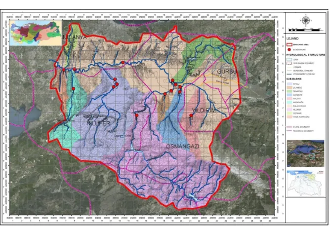
Borders of study area is composed of Ba�köy - Kestel section and lower catchment basins within catchment basin of Nilüfer Stream (stems form south of the Mount Uludag and joining Susurluk Stream in Karacabey Plain and then reaches the Marmara Sea) which is 1.288,96 square kilometers large and flows through province of Bursa (northern latitudes of 28°10’ and 30°00’ and eastern latitudes of 40°40’ and 39°35') (Figure 1).
Due to physical geographical features of the study area, pollutions appear as above the ground water pollution carried with the surface waters directed by the hydrological characteristics, soil pollution and underground water pollution. With regards to this issue, local municipalities, respective public agencies and universities have been conducting pollution studies in respect of the Stream Nilüfer in particular.
Also, causality and relations between soil and air pollutions as well as changes in water quality have been revealed in this study. With such purpose in mind, water quality analyses conducted by DS i (State Hydraulic Works), BUSKi (Bursa Hydraulic Works) and universities have been considered under the light of Ecological Risk Assessment starting from lower catchment basins and continuing with the study area formed by these lower catchment basins, and group of relationships between water qualities measured at the main branches of catchment basins and crossroads by using universal parameters (and the other respective factors such as air pollution ) and industries and land uses peculiar to them have been revealed.
Figure 1. Research area boundaries
While conducting ecological risk assessment for the Stream Nilüfer catchment basin, steps such as problem formulation, analysis and risk detection, the main frame of the Ecological Risk Assessment model of the US Conservation Agency have been taken as basis. Additionally, pressures and effects terminology of Water Framework Directive (WDF) model of EU where natural conditions linked with the geographical characteristics are evaluated apart from chemical analyses have been included in the evaluation. As a consequence, positive aspects of these analyses have been evaluated together and a mixed Ecological Risk Analysis method possessing a catchment basin approach has been configured. A short summary of the risk analysis method configured is as follows;
I. Phase: Definition of problem:
• Definition of geographical space components
• Assessment of the data so gained according to natural resources of water catchment basin , existing and past land uses and master plans
• Formation of ecological conceptual model which lays down relationships between activities which are called source of pressure and cause these pressures and ecological effects of these pressures and ecological values that need to be preserved in order to define the risks
II. Phase: Analysis:
Journal of International Scientific Publications:
Ecology & Safety, Volume 7, Part 3
ISSN 1313-2563, Published at: http://www.scientific-publications.net
• Assessment of pollutions according to international standards (upper and lower limit values) III. Phase: Evaluation of Risks:
• Overlaying all data derived according to risk factor weights depending on the features of physical geographical features and creation of risk maps as a result
• Assessment of risks caused by the changes related to current and past land uses and risks caused by the planned and unplanned developments depending on the zoning plans.
Results derived from analysis conducted by taking this as a starting point have been revealed within framework of holistic cause – effect relations (existing pollution and risks of pollution). Thus, zoning studies and synthesis maps where ecological thresholds have been determined have been gained.
3. RESULTS AND DISCUSSION
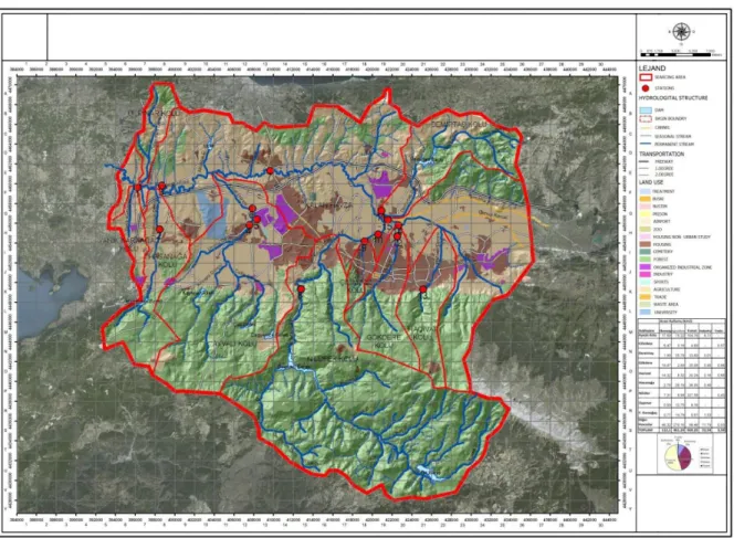
When looking into current and use of Bursa Stream Nilüfer Ba�köy – Kestel section and lower catchment basins (Figure 2.), it has been observed that, as a result of decisions made by the governments, function areas such as housing and industry located on the first class agriculture land and areas composed of rocks with geologically high permeability give rise to pollutions on the natural resources which comprise the water catchment basin at a scale that is above the acceptable limits according to the international standards.
Discharging of fertilizers and pesticides used in the agricultural areas and process wastes of industrial fields into the stream Nilüfer, soil and underground water by means of wells, duping of domestic wastewaters stemming from housing areas into the Stream Nilüfer or the wells, and leakages in the sewerage system of some areas and emissions caused by transportation cause pollution in the underground and surface waters.
Since section of stream Nilüfer from its source in the Mountain Uludag to the city center of Bursa which is used for irrigation in Bursa Plain is deemed unpolluted since it demonstrates high dissolved oxygen (DO), low biological oxygen requirement (BOR5) and chemical oxygen requirement (COR)
value . However, in those portions of stream which pass through city center and move towards Bursa Plain, DO value of Stream Nülüfer drops, and a increased rates of BOR5 and COR values and high
concentrations of lead, nickel, zinc, chrome and copper are worth attention.
When assessed in respect of water quality, although at the source of Stream Nilüfer, water quality is the 1st class water according to parameters, water gets polluted 500 times at the 4th km (Figure 2: M14), 10.000 times at the 14th km (F18) and 65.000 times at the 38th km (E6) and turns into the 3rd and 4th class water quality. Major reason of this phenomenon is the fact that physical – biological and ecological characteristics of the natural resources of the study area have been ignored, and water, soil and air pollution caused by industrial and urban or rural settlements located in the study area as a result of the negative effects caused by the decisions on land use. It is seen that only 10% of such pollution is caused by domestic wastes while the remaining major part of it is pollutions caused by the industrial wastes.
Figure 2. Actual land use (Küçükali 2012)
Bursa Plain is one of the most important agricultural areas around the region and the entire country, and since it caters for food requirement of a large population, pollutions directly affect all live beings and humans as a result of water taken from the Stream Nilüfer being used as irrigation water on agriculture fields (especially, sodium, boron and heavy metals). Due to irrigation water containing heavy metals, toxic substances find their way into the food chain via plants and give rise to major health problems.
Activities caused by the industrial use on the study area seem to give rise to air, water and soil pollution. Industrial uses causing pollutions in the study area enterprises, mining operations (Figure 2: E26, K13, O21, O23), storage areas (E26, F12, K13), textile (K8, F14, G12-14, H14, E19-20, I24, J12, J24-27) automotive (F19-20, H14-15, I13, J6-9-12), leather (K19, H19-20), cement (H20, J15), metal (G11-12), food (G14-15, I13, K7), rubber and plastic industries (H12-13), tan yards (I18-19), dyeing plants (H19, J20), mineral processing workshops (I20, K11, N19) and quarries (E26, K13, O21, O23). Industrial establishments founded along the stream Nilüfer pollute the stream Nilüfer with waste waters on one side, and settlement areas create air pollution over agricultural fields and the Stream Nilüfer on the other side. This air pollution reach the agricultural fields and surface waters as a result of inversion movements. In the study area, the single most important effect giving rise to pollution in the water quality of the stream Nilüfer as a result of the industrial activities is discharging of industrial
Journal of International Scientific Publications:
Ecology & Safety, Volume 7, Part 3
ISSN 1313-2563, Published at: http://www.scientific-publications.net
with the same sector. Since chemical characteristics of the pollution components are different, effect of every industry on the water quality of the Stream Nilüfer is different.
The Organized Industrial Sites operating in Bursa have their own treatment plants, yet these plants are not operated at adequate level and efficiency, and wastewaters treated chemically and physically are discharged into the Stream Nilüfer before being biologically treated.
Besides, air pollution occurs as a result of discharging of the chimney gases of Orhaneli Thermal Power Plant without proper treatment, and chimney gases created by use of low quality coals for heating in downtown Bursa and rural settlement areas and exhaust emissions of the vehicles. Therefore, since dominating wind direction is north east, polluted air that is unable to climb over the Mount Uludag which is the natural threshold area to the south of the study area suspends in the over the city center, and soil, water sources and vegetation are negatively affected by the inversion and acid rains.
Apart from the pollutions caused by agricultural applications and industrial activities, pollutions caused by the settlement areas have been detected in the study area. Looking into space distribution of the different types of houses in the study area, we see that majority of them is composed of areas irregularly developed. Part of these areas have been legalized once again through improvement plans (Figure 2: D13, F15, G15), and part of them is composed of settlement areas developed in the form of multiple housing (Figure 2: G9, H8, K9). Looking into relationship of the housing areas with the water catchment basin, some of them are located inside Bursa Plain containing fertile agriculture fields and forest areas.
Until 1997, domestic waste water of the settlements located in the catchment basing used to be discharged into the Stream Nilüfer. There are still settlements which discharge their domestic wastes into the stream Nilüfer without getting connected to BUSKi waste water collection collector. In the rural settlements, since infrastructure has not been completed yet, domestic waste waters are discharged into Stream Nilüfer by means of small creeks or into underground water via illegal wells. In this way, pollutions reach the underground water, and waters taken from the wells opened in Bursa Plain are used as irrigation water for agriculture. Besides, pollutions that reach the stream Nilüfer from the underground water contact the soil with the irrigation water taken from the stream Nilüfer and reach the food chain.
When looking into pollutions caused by the transportation in the study area, although there is no scientific study conducted about this issue in the study area, analyses conducted show that solid particles and polluting gases emitted by the vehicles reach the stream Nilüfer by air or soil, underground waters and the stream Nilüfer by means of inversion. Heavy metals stemming from exhaust fumes of the vehicles passing through the orbital road, a portion of which is on viaducts, (lead, asbestos, cadmium and the others) spread to the agricultural areas in the vicinity, and the agricultural fields are under pressure in respect of pollution in a large range due to air movements. Also, polluting particles that lift of the ground due to abrasion of car tires as a result of friction become part of the food chain after reaching the surface waters, undergrounds waters and soil as a result of inversion. Also, characteristics of the fuel consumed by vehicles (solvents etc.), profile depth of the tires are not in compliance with the conditions specified in the European Environment Legislation. Especially orbital road that is located along the Stream Nilüfer gives rise to pollution risk in respect of dense traffic. Also, when looking into pollution risks caused by the fact that landing and take-off routes of the airlines being above the agricultural fields, dense plane fuel wastes discharged by the planes at the time of take-off in particular merge with Stream Nilüfer or soil, and thereby, the underground waters. Location of Bursa Yeni�ehir Airport posses the same risks in respect of the nearby agricultural fields. Land use reports issued without taking into consideration ecological – biological – physical characteristics of the natural resources give rise to the results derived from this study Planning and
planning phases are of paramount importance.
The Law on Zoning numbered 3194, planning process of our country is defined as follows: This processes is defined with area plan, environmental plan, master plan and tentative plan phases. In this order, area plan and environmental plan create upper scale plans. In our country, area plan is done in order to reflect the social-economical plans on the space. However, apart from social-economical decisions, an area planning understanding that contains and take into consideration the ecological and biological characteristics of the natural resources has not matured in our national planning practice. Those plans which take into consideration the social - economical decisions alone as proven by the considerations contained in the thesis, give rise to destruction of natural resources and environmental pollution.
Upper scale planning offers an opportunity in terms of conserving the resources; however, catchment basins or another natural criterion have not been rendered decisive for the parameters that will be the basis of the existing plan definitions. Also, the fact that area planning is not compulsory in the legal platform causes omission of planning stage in practice. It has been only a short time since the environmental plans have started to be prepared across the country. Potential for understanding ecological integrities of adoption of a environmental plan in our country’s planning practice as an upper scale plan is inadequate, and it is obvious that environmental problems are caused by the fact that these plans have been drawn up by taking into consideration boundaries of provinces. In the absence of upper scale plans, environmental plans are being executed in the city scale with master and tentative plans in our country’s planning activity, and these plans are not made with foregoing characteristics, qualities and phases, and do not contain adequate ecological considerations. Likewise, master plan and tentative plans of the lower scale do not lay down physical and ecological characteristics of the natural resources and potentials of the natural resources. For water catchment basins that are of importance in terms of nature, it is obvious that Ecological Master Plan must be drawn up prior to the abovementioned area plan and such plan must be decisive in planning of the natural resources according to conservation – use characteristics.
In the water catchment basin planning suggested, in order for the geographical – physical structure of the water catchment basins and their ecological characteristics to be reflected upon planning decisions, legislation that will direct and support the planning must be developed in this direction and international conventions must be put into force and effect. Since existing laws and regulations regarding water catchment basins (environment law, zoning law, law on conservation of soil and use of land, regulation on control of water pollution, regulation on conservation of water resources, regulation on conservation of water catchment basins, regulation on environmental impact assessment and the others ) do not have adequate conservation precautions, conservation precautions related to pollution must be established and applied separately for each and every catchment basin that has specific ecological conditions and natural resource potential (Küçükali 2012).
4. CONCLUSIONS
Ecological Planning and catchment basing planning related to the same is a planning approach, at a scale above the space planning, which lays down principles of conserving biological and ecological characteristics of the natural resources and assuring balance of conservation – utilization, ensure that resources are managed wisely, and the issues are addressed within integrity.
If planning is directed by implementing projects of reviewing and gentrification of those land uses which are not ecologically appropriate in the settlement areas according to “Ecological Planning”
Journal of International Scientific Publications:
Ecology & Safety, Volume 7, Part 3
ISSN 1313-2563, Published at: http://www.scientific-publications.net REFERENCES
Atabay, S 1991,‘Compatible with the natural environment planning’, Cumhuriyet Newspaper, 5 Kas1m, p.5.
Bogaziçi University 1992, Examination of pollution and quality determination of water basins project: Susurluk Basin, Republic of Turkey Ministry of the Environment technical report no: 23, Institute of Environmental Sciences, Istanbul, Turkey.
Bursa Metropolitan Municipality 2002a, Bursa wastewater master plan, Environment technical report no:18, GIBB Tabar, Bursa, Turkey.
Bursa Metropolitan Municipality 2002b, Bursa water resources and current quality, Environment technical report no:37, Bursa, Turkey.
BUSKi 2009, Bursa environment, water supply and sewerage project, Bursa Water and Sewage Administration, Environment technical report no:22, Bursa, Turkey.
Dedeoglu, Y 2000, ‘Pollutant resources of surface waters in Bursa and determination of pollutional load of Nilufer Stream together with recomended solutions’, Master of thesis, Uludag University, Bursa, Turkey.
DSi, 1984, Bursa Province Water Resources Pollution Research: 1979 - 1982, State Hydraulics Works, Ankara, Turkey.
DSi, 2000, Susurluk River Basin Water Quality Management: 1998 - 1999, State Hydraulics Works, Ankara, Turkey.
Kaynak, A. G 2002, ‘Wastewaters Originating from Bursa City Center, Their Treatment and Effects on Nilüfer Stream’, Master of thesis, Uludag University, Bursa, Turkey..
Kestioglu K & Karaer, F 1994, ‘Bursa Nilufer River Pollution Survey’ paper presented to the scientific meeting of the Gulf of Gokova Symposium on Environmental Issues and Environmental Management in Uludag University, Bursa, Turkey.
Küçükali, UF 2012, ‘Pollution and risk analysis for Ba:jköy - Kestel section and sub-basins of Bursa Nilüfer Creek’, Ph D thesis, Yildiz Technical University, Istanbul, Turkey.
Küçükkball1, A 2003, ‘Determination of Water Quality in Nilüfer Stream Basin and Investigation of Some Parameters with QUAL 2E Model’, Master of thesis, Uludag University, Bursa, Turkey.
TUBiTAK, 2005, Preparation of the project of the national action plan for land based pollutants: – Marmara Sea basin, Ankara, Turkey.