DOI 10.1007/s10661-008-0495-z
National assessment of sea level rise using topographic
and census data for Turkish coastal zone
Tuncay Kuleli· Ozan ¸Senkal · Mustafa Erdem
Received: 14 February 2008 / Accepted: 24 July 2008 / Published online: 20 August 2008 © Springer Science + Business Media B.V. 2008
Abstract Turkish coastal zone elevation to sea level rise was illustrated by using digital eleva-tion model and Geographical informaeleva-tion systems methods. It was intended to determine sev-eral parameters such as population, settlements, land use, wetlands, contribution to national agri-cultural production and taxes at risk by using high resolution SRTM topographic, orthorectified Landsat Thematic Mapper Mosaics and census data with GIS methods within 0–10 m elevation of national level. All parameters were examined for coastal cities, coastal districts, settlements and villages’ status. As a result of the analysis of data set, it was found that approximately 7,319 km2of
land area lies below 10 m contour line in Turkey, and is hence highly vulnerable to sea-level rise. 28 coastal cities, 191 districts and 181 villages or towns are located below 10 m contour line in study area. In the short term, for the struggle of negative impact of sea level rise, the findings
T. Kuleli (
B
)University of Cukurova, Adana, Turkey e-mail: [email protected]
O. ¸Senkal
KaraisalıVocational School, Çukurova University, 01770 Karaisalı, Adana, Turkey
M. Erdem
Faculty of Fisheries, Mugla University, 48000, Kotekli, Mugla, Turkey
suggest that the Ministry of Environment should declare new areas as protection areas and develop special environmental programs for national level. Keywords Coastal zone· Elevation ·
Sea level rise· SRTM · Turkey
Introduction
International Panel on Climate Change reports that climate change will have many negative effects, including increased intensity of storms, floods and droughts, rising sea levels, and loss of biodiversity. Sea level rise (SLR) causes extra-ordinary threat to countries with high density of population and economic activity in coastal areas. Until now, SLR researches estimated a 0–1 m rise during the 21st century (Church et al.2001; IPCC Third Assessment 2001).
Model projections of the IPCC SRES scenarios give a global mean sea-level rise of 0.09 to 0.88 m by 2100, with sea level rising at rates approxi-mately two to four times faster than those of the present day (EEA 2004; Meehl et al. 2007). Sea level rise until this moment has also been signifi-cantly faster than the level predicted in the 2007 IPCC reports. In Europe, regional effects may result in sea-level rise being up to 50% higher than these global estimates (Woodworth et al. 2005). The impact of the North Atlantic Oscillation on
winter sea levels provides an additional uncer-tainty of 0.1 to 0.2 m to these estimates (Hulme et al.2002; Tsimplis et al.2004).
The rate of sea level rise for the last 20 years was 25% faster than in any other 20-year pe-riod, the main reasons are supposed to be ocean thermal expansion and melting from non-polar glaciers. There had been a close relationship be-tween temperature and sea level rise throughout the 20th century, as sea levels rose at a rate of about 2 mm per year per degree Fahrenheit. Ap-plying this relationship to future warming scenar-ios implies that sea level will rise between 50 and 140 cm by 2100. This estimate is much higher than the IPCC Third Assessment Report estimates of 21 to 70 cm by 2100 and the fourth Assessment Report estimates of 18 to 59 cm by 2100. The bot-tom line is that if the current relationship between warming and sea level rise continues, the IPCC estimates would be unrealistic, and sea level rise of more than 1 m by 2100 is a real possibility.
Several studies have showed the estimates of the potential impacts for some developed coun-tries (Baarse et al. 1994; Bijlsma et al. 1996; Ng and Mendelshon2005; Zeidler1997); developing countries (Adam1995; Dennis et al.1995; French et al.1995; Han et al.1995; Warrick et al.1996); or specific areas of the world (Yim1995). Only few studies such as: Nicholls and Mimura (1998), and Nicholls and Tol (2006), have estimated the im-pacts of SLR on a great extent of regional or world scale. These studies research the impact of such extreme climate scenarios as a 5 m SLR. However, while indicators of impacts mostly include land loss, population affected, capital loss value and wetlands loss, different studies used different in-dicators or regions, making it difficult to compare the relative magnitude of impacts across countries or regions.
Although a national evaluation hasn’t been conducted related to SLR in Turkey, several local research was carried out on coastal flood risk analysis and quantitative coastal inundation vul-nerability of Turkey to SLR until the year of 2205 (Demirkesen et al.2007,2008).
In this research, several parameters such as population, settlements, land use, wetlands, con-tribution of national agricultural production and taxes at risk were determined by using GIS
meth-ods with high resolution SRTM topographic, or-thorectified Landsat Thematic Mapper Mosaics and census within 0–10 m elevation of national level. All parameters were examined under the range of coastal city, coastal district, settlements and villages status.
The coastal environment of Turkey
Turkish coastal environment was researched part by part from different points of view. The most im-portant information source about Turkish coasts is the proceedings of Turkish Coasts Conference, conducted by Turkish National Committee on Coastal Management, bi-annually since 1997 and published with the title “Turkish Coasts: The National Conference on the Coastal and Marine Areas of Turkey”. The six volumes published up till now are widely used and serve as the basic source of information for coastal and ma-rine environments of Turkey. The most recent research document, Coastal Area Management in Turkey, was prepared by the author Prof. Erdal Ozhan who is the Chairman of MEDCOAST (PAP/RAC 2005) and was published by the Pri-ority Actions Program, Regional Activity Centre of the Mediterranean Action Plan. According to this research document, the Turkish coastal envi-ronment was briefly described as follow;
The total length of the Turkish coastline includ-ing the islands is 8,333 km, of which 1,067 km are island shores. The distributions of this total according to the four seas are the Black Sea: 1,701 km (20.4%), the Sea of Marmara: 1,441 km (17.3%), the Aegean Sea: 3,484 km (41.8%), and the Mediterranean: 1,707 km (20.5%) (Gunay
1987). These four coastal regions show distinct ge-ographical features. Mountain ranges run parallel to the coast along the Black Sea coast, especially in the eastern part, limiting the size of the coastal area to extreme minimums on one hand and bring-ing a marked influence on the climatology the region on the other. The western Mediterranean coast has geological features similar to the eastern Black Sea coast, e.g. high mountain ranges run-ning in close proximity to the shoreline. However, the climatology of this coast, which is basically Mediterranean, is far different. Along the eastern Black Sea and the western Mediterranean coast,
the width of the coastal area is very narrow (in the order of a few hundred meters), thus ren-dering the area unsuitable for many coastal uses including urbanization. Along the Aegean coast, the mountains run perpendicular to the coast, thus allowing the rivers like Buyuk Menderes to form fertile alluvial plains and productive deltas. Due to the perpendicular orientation of the mountains, the Turkish Aegean shoreline is highly indented, housing numerous bays and coves that have been inhabited by humans since historic times. This makes the Aegean coast extremely important with respect to the presence of invaluable cultural sites and resources, and thus a prime area for tourism and recreation, and other coastal uses that are also supported by numerous coastal features and natural attractions.
Other alluvial plains are located along the western Black Sea coast (like those of Kizilirmak and Yesilirmak) and the middle to eastern Mediterranean coast (like the plains of Goksu, Seyhan, Ceyhan and Asi). The coastal area along these alluvial and deltaic shores widens signifi-cantly from a handful of kilometers to a few tens of kilometers, presenting agricultural land of the highest productivity.
The coastal area around the Sea of Marmara is generally suitable for human development. The terrain is not as rugged as the eastern Black Sea and the western Mediterranean coast. The prox-imity to the City of Istanbul and to Europe has contributed to the potential development value of the Marmara coast, which is relatively more developed and densely populated.
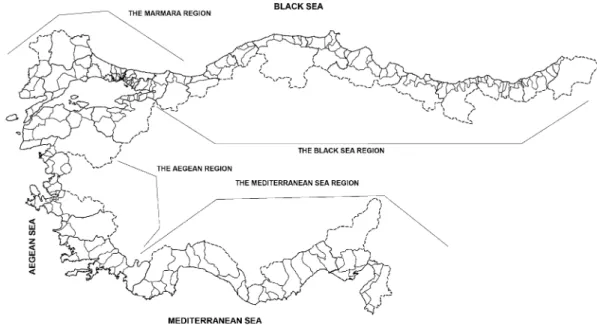
Turkey is divided to seven “geographic re-gions” and four of these are named after the sea that they border. The Black Sea (Karadeniz) Re-gion is often referred to in two parts: the eastern and the western Black Sea regions. These “geo-graphic regions” are very large areas. At a lower level, are the provinces that are basically political (administrative) units. The provinces of Turkey that have a coastline along at least one of the four seas are. The four coastal geographic regions and their coastal provinces are:
1. The Black Sea Region: Artvin, Rize, Trabzon, Giresun, Ordu, Samsun, Sinop, Kastamonu, Bartın, Zonguldak, Duzce and Sakarya;
2. The Marmara Region: Istanbul, Kirklareli, Tekirdag, Edirne, Canakkale, Balikesir, Bursa, Yalova, and Kocaeli;
3. The Aegean Region: Izmir, Aydin and Mugla; 4. The Mediterranean Region: Antalya, Icel,
Adana and Hatay.
The boundaries of the provinces have been drawn based on administrative features. The coastal provinces in all cases occupy both coastal and inland land areas. A further administrative divi-sion exists within provinces (districts—“ilce” in Turkish) (Fig.1).
Turkey is one of the riches countries in terms of wetlands in Europe. The wetlands cover an area of 1,851,000 ha in Turkey including the artificial lakes. Some 58 out of a total of 250 wetlands of Turkey are labeled as “internationally impor-tant”, and 18 of these are acknowledged as “Class A” wetlands. Seventy-six wetlands having a total area of 1,240,000 ha are indented as important bird sanctuaries (Ministry of Environment2002). Out of nine wetlands (having a total area of 159,300 ha) that are included in the Ramsar List, four are located in the coastal zone (Goksu Delta, Gediz Delta, Akyatan Lagoon, and Kizilirmak Delta) (Ministry of Environment2001).
Turkey has 72 lagoons of various sizes, distrib-uted along her long coastline. The Aegean coast is the richest in terms of the number of lagoons, total lagoon area (about 20,000 ha) and fish pro-duction (about 562 tons per year). Two lagoons— Bafa and Koycegiz—account for 60% of the total area. The lagoons along Turkey’s Black Sea and Mediterranean coast are found mainly as parts of the deltaic systems. Lagoons of the Kizilirmak Delta in the western Black Sea coast and those of the Goksu, Seyhan and Ceyhan Deltas in the east-ern Mediterranean coast are among the important pristine nature preservation areas (Deniz2002).
The length of the Turkish coastline with sand dunes is about 845 km. Until recently, coastal dunes were significantly damaged by road con-struction, plantations, sand extraction, secondary houses and tourism projects (SPO2001).
Agriculture in the coastal regions is most important over the alluvial deposits of the major rivers such as Yesilirmak and Kizilirmak (Black Sea), Gediz, Buyuk Menderes and
Fig. 1 Turkish coastal regions, cities and districts map
Dalaman (Aegean), Goksu, Seyhan and Ceyhan (Mediterranean). The products are usually vari-eties with high market values, including cotton, tobacco, tea, citrus and other fruits, olives and grapes. Since the 1989s, the agricultural sector has been consistently loosing to tourism development and services invariably in the tourism centers along the Aegean and the Mediterranean, and to industry and urbanization around the Sea of Marmara.
Sea level monitoring/measurement
Sea level monitoring and measurement activities are realized by General Command of Mapping in Turkey. Yildiz et al. (2003) reported these activi-ties as follow;
Turkish National Sea Level Monitoring System (TUSELS) at present has Ankara data center and tide gauge stations namely Antalya-II and Erdemli at Mediterranean coasts, Bodrum-II and Mentes at Aegean Sea coasts, Erdek at Sea of Marmara coast, Amasra, Trabzon-II and Igneada at Black Sea coasts and the works for the enlarge-ment of TUSELS still function. Under the frame of TUSELS, sea level measurements and
ancil-lary meteorological parameters are collected dig-itally with high accuracy. At the data center, the activities of transferring, quality control and analysis of tide gauge data are done. The calcu-lation of the hourly sea level values for the other years is based on the tidal constituents obtained taking into consideration the tidal prediction. Then, hourly sea level values of 18 years (1985– 2002) for Antalya-II, Bodrum-II and Mentes tide gauges and of 19 years (1984–2002) for Erdek tide gauge are quality controlled by comparing them with the predicted values by removing da-tum shifts and time errors as much as possible. A 119-point low-pass filter is applied to the hourly sea level values in the computation of daily values and the daily values are used to obtain monthly values with a simple average. Harmonic analysis is applied to the monthly sea level values of four tide gauges and mean sea levels (MSL) and rel-ative changes of MSLs are calculated. This pro-cedure yields relative MSL changes at Antalya-II, Bodrum-II, Mentes and Erdek as 8.7± 0.8 mm/yr, 3.3 ± 1.1 mm/yr, 6.8 ± 0.9 mm/yr and 9.6 ± 0.9 mm/yr respectively. While the relative mean sea level change at Bodrum-II is found to be in good agreement with the global sea level rise estimates, it is found to be much higher than
< w
"'
z < w 1B < MEDITERRANEAN SEA BLACKSEA '-,,._ı:_\ _____ r-..._,,._ -\-... "-", 1r-:,c;;:~---c1ı-nı--V"'"'> '--(....,.)'\ (---~, .... .!;;the global sea level rise estimates at Antalya-II, Mentes and Erdek tide gauges.
Data and method
A rise in sea level would cause erosion and inun-dation, and also move the zones at risk of flooding upward and landward (Nicholls et al. 1999). Ac-cording to Behnen (2000), areas below 10 m level are most vulnerable to sea level rise. Lower slopes experience a greater increase in flood risk due to sea level rise than steeper slopes (Nicholls et al.
1999).
Extensive assessments of sea level rise need ex-act maps of the whole coastal zone, but map scales and accuracy change nation by nation. Given that the typical error in SRTM altitudes is of the order of 3 m in most coastal areas (Rodriguez et al.
2005), there may be better local data for our re-gion of interest while the Shuttle Radar Topogra-phy Mission (SRTM) dataset at 90 m resolution is the best publicly available topographic datasets for near-global use.
The SRTM digital elevation data, produced by NASA originally, is a major breakthrough in digi-tal mapping of the world, and provides a major ad-vance in the accessibility of high quality elevation data for large portions of the tropics and other areas of the developing world. The SRTM 90 m DEM’s have a resolution of 90 m at the equator, and are provided in mosaiced 5 deg× 5 deg tiles for easy use.
Landsat data was provided through NASA’s Earth Science Enterprise Scientific Data purchase Program Produced, under NASA contract, by Earth Satellite Corporation. Data set title is Geo-Cover Orthorectified Landsat Thematic Mapper
Mosaics published by NASA Stennis Space Cen-ter. These data are available with no copyright restriction and can be obtained from the Land Processes Distributed Active Archive Center at EROS Data Center.
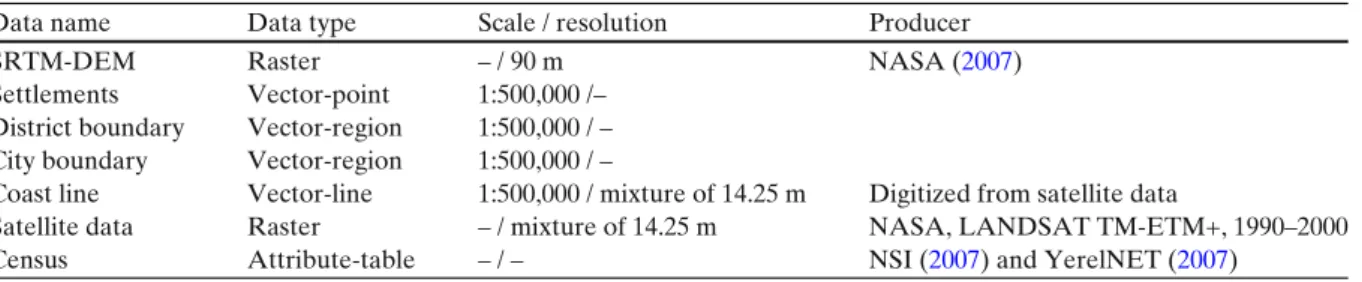
As can be seen in Table 1 vector, raster and tabular data were used. As census data, city and district population was obtained from National Statistical Institute (NSI 2007) census. Village and other smaller settlement’s population was obtained from local government web portal of Turkey which was developed by the Local Gov-ernment Research and Training Centre of The Public Administration Institute for Turkey and the Middle East and financially supported by the Turkish State Planning Organization (YerelNET
2007). Population increment rate, population den-sity, income from national budget for each per-son, income tax rate and agricultural production rate were obtained from Dincer and Ozaslan (2004Grading to Districts by according to Socio-economical development).
Vector data In order to create GIS database
point and region vector data were used. The point vector data was settlements, and cities and the region vector data was districts and boundary. Vector data were extracted from 1:500,000 scale cartographic maps by manual digitizing methods.
Software Global Mapper software was used to
process raster data like scanned maps and SRTM data. On the other hand MapInfo software was used to establish vector and attribute database in GIS.
The GIS model was used in this assessment by using spatial coastal data combined with common sea level rise projections. In general definition GIS consists of computer hardware, software, data,
Table 1 Data source and type
Data name Data type Scale / resolution Producer
SRTM-DEM Raster – / 90 m NASA (2007)
Settlements Vector-point 1:500,000 /– District boundary Vector-region 1:500,000 / – City boundary Vector-region 1:500,000 / –
Coast line Vector-line 1:500,000 / mixture of 14.25 m Digitized from satellite data
Satellite data Raster – / mixture of 14.25 m NASA, LANDSAT TM-ETM+, 1990–2000 Census Attribute-table – / – NSI (2007) and YerelNET (2007)
Fig. 2 GIS data model and procedures
methods, and personnel that functions as an au-tomatic system for the capture, storage, update, retrieval, manipulation, analysis, management, and display of all forms of geographically refer-enced information. GIS data model and proce-dures were given in Fig.2.
A first-order estimate of potential losses of land to SLR was arrived at by integrating dig-ital elevation data with the above sea-level rise scenarios using a geographical information system (GIS). In the first step average tidal range values were estimated for all coastal administrative units. Then, based on these values and using the eleva-tion dataset, land area loss as a funceleva-tion of sea-level rise was calculated for each administrative unit. In this step, low-lying inland areas and water bodies were masked out. First-order estimates of
population exposure to SLR were calculated by combining the above data. These datasets were then used to calculate resident coastal population counts for the areas lost based on 2007 census data.
Results and discussion
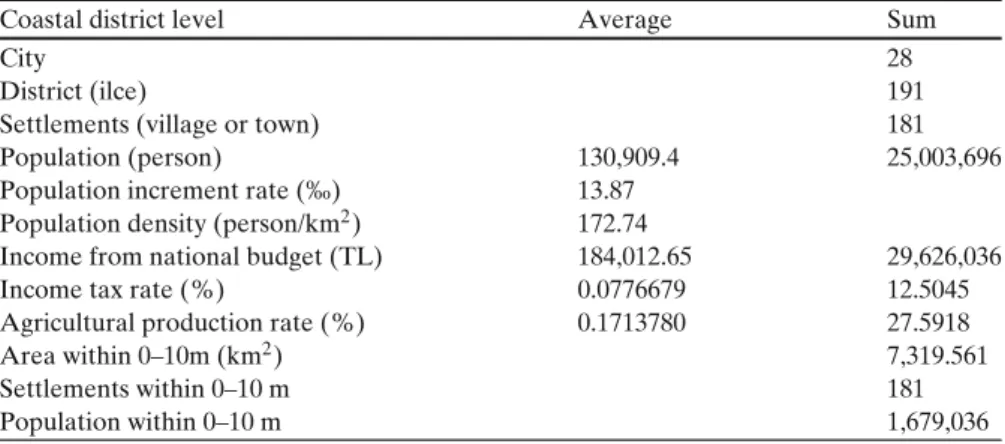
Turkish coastal zone elevation to sea level rise was illustrated by using Digital Elevation and GIS models. Table2shows general results of national assessment. As a result of the analysis data set, approximately 7,319 km of land area lies below 10 m contour line in Turkey, and is hence highly vulnerable to sea-level rise. 28 coastal cities, 191 districts and 181 villages or towns are located in the area below 10 m contour line. Thus, approx-imately 10% of national land lies within 0–10 m contour line. These districts have significant val-ues for agricultural production, population, taxes and income. For example, over 25 million people live in these areas and nearly 27.5% of national agricultural production and 12.5% income tax ob-tained from these coastal areas.
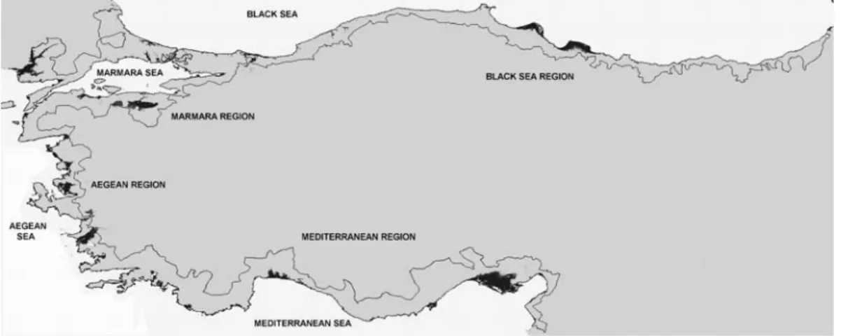
In order to estimate the total extent of the regions at risk by SLR, various data on national land distribution with respect to the elevation above sea level were compiled. Figure3shows us potential coastal land loss from inundation only, in the event of an increase in global mean sea level of 10 m, excluding protection and erosion.
Figure 4 illustrates the spatial distribution of these land areas below the 10 m line, the land
Table 2 General results
of national assessment Coastal district level Average Sum
City 28
District (ilce) 191
Settlements (village or town) 181
Population (person) 130,909.4 25,003,696
Population increment rate (‰) 13.87 Population density (person/km2) 172.74
Income from national budget (TL) 184,012.65 29,626,036
Income tax rate (%) 0.0776679 12.5045
Agricultural production rate (%) 0.1713780 27.5918
Area within 0–10m (km2) 7,319.561 Settlements within 0–10 m 181 Population within 0–10 m 1,679,036 Extract: 10 m contour line from SRTM
•
Overlay: 0-10 m region, City, District, Settlements GIS Oatabase PROCEDURES Tabulation: According toregion and cities
Results:
Maps and
Fig. 3 Distribution of
land area within 0–10 m
distribution rises as a linear function of the el-evation above the mean high water line. There are large areas within 10-m elevation of present high water, partly reflecting the extensive areas of natural and intertidal habitats around Turkish shores.
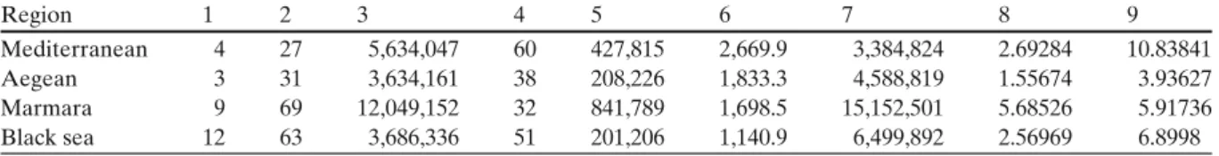
Turkey has a long coastal zone, the character-istics of which change region by region. Hence, potential land loses and other risks due to the sea level rise were examined according to the regions. Regional vulnerability calculated using nine pa-rameters, was given Table 3. As can be seen in Table 3, although Marmara Region is the most vulnerable area in terms of population at risk, Mediterranean Region is the most vulnerable area for potential land losses.
Global sea level rise for the last century has been estimated between 10 and 20 cm for the Mediterranean and Black Sea regions, the sea level rise is around 12 cm in the last century (MoEF2007). Although coastal settlements below 10 m contour line cover nearly 10% of total land coverage of Turkey, over 25 million people live in coastal area.
Sea level rise along the Turkish coast is not likely to be as significant as in some other areas around the world but there will be local vulnera-bility due to topography and subsidence; Regional sea-level rise is not that well understood and there is a lack of consistency between simulated pat-terns of change. In many cases, regional efforts will be more efficient in terms of developing and
Fig. 4 Coastal areas below 10 m elevation above the present mean sea level
Distribulion of land area within 0-1 Om
8000 ~ -7000 + - - - ~ = - -6000 + - - - , c 5000 +-- - - ----c 4000 +-- - - ---= 3000 + -2000 + - - - 7 " ' 1000 +-- --,,--o +-_ı-'--~-L-~--'-~---'---~...l...-~'---'--•Area (km2
Table 3 Regional vulnerability Region 1 2 3 4 5 6 7 8 9 Mediterranean 4 27 5,634,047 60 427,815 2,669.9 3,384,824 2.69284 10.83841 Aegean 3 31 3,634,161 38 208,226 1,833.3 4,588,819 1.55674 3.93627 Marmara 9 69 12,049,152 32 841,789 1,698.5 15,152,501 5.68526 5.91736 Black sea 12 63 3,686,336 51 201,206 1,140.9 6,499,892 2.56969 6.8998 1 City, 2 districts, 3 populations, 4 settlements (within 0–10 m), 5 populations (within 0–10 m), 6 areas (within 0–10 m), 7 income from national budget (TL), 8 income tax rate (%), 9 agricultural production rates (%)
assessing adaptation options, a regional perspec-tive would provide a useful link between research and policy at the national and global scales.
Coastal erosion, flooding and inundation along Turkish shorelines are problems of na-tional significance, particularly in the Aegean and Mediterranean regions and also within two important agricultural deltaic plains in middle parts of Black Sea region. Touristic coastal cities are particularly under threat which will cause destruction of many cultural sites by sea level rise like ancient cities in Mediterranean and Aegean regions. Deltaic coasts are expected to undergo a shoreline change due the rising sea level that will result in increased flooding across the delta plain causing interruption of agricultural activity.
Turkey, being a coastal country, recognized the increasing number of problems in coastal zones and many safety measures are being taken by several governmental institutions and agencies (MoEF 2007). For example, most of the areas located in the Aegean and Mediterranean coasts are declared as protection zones by the Turkish government. In a short term, for the struggle of negative impact of sea level rise, The Ministry of Environment should declare new areas as pro-tection zones and develop special national level environmental programs.
There are some uncertainties in national and regional climate change scenarios, as these mainly consist of simple downscaling of global scenar-ios, based on model-driven scenarios with lim-ited variables. Frequently, sea level rise is used as the unique indicator of climate change. Also, the number of exposure or sensitivity variables is entirely limited. Therefore the assessment results of global studies can not be used in spatial plan-ning and for decision-making on a regional scale. There is also considerable uncertainty regarding
sea level rise and its impacts, for this reason the selection of adaptation options are very difficult. Especially, there is a lack of regional, national and site specific data that is needed to make decisions on adaptive options. There is a great need to iden-tify those areas that are most vulnerable to the impacts of sea level rise. The identification should focus on densely populated low lying areas and deltas. The need for common database arrange-ments to promote exchange of information and international databases accessible to all nations has also been identified. At this time, sea level rise scenarios are difficult to develop due to our defec-tive knowledge of the local and regional factors. All the uncertainties must be considered when explaining impact and response assessments.
References
Adam, K. S. (1995). Vulnerability assessment and coastal management program in the Benin coastal zone. In P. Beukenkamp (Ed.), Proceedings of WCC93. CZM management publication no. 4 (pp. 489–501). The Hague: National Institute for Coastal and Marine Management.
Baarse, G., Peerbolte, E. B., & Bijlsma, I. (1994). As-sessment of the vulnerability of the Netherlands to sea-level rise. In J. O’Callahan (Ed.), Global climate change and the rising challenge of the sea, proceedings of the 3rd IPCC CZMS workshop, Margarita Island, March 1992 (pp. 211–236). NOAA, Silver Spring, MD. Behnen, T. (2000). Der beschleunigte Meeresspiege-lanstieg und seine sozioökonomischen Folgen: Eine Untersuchung der Ursachen, methodischen Ansätze und Konsequenzen unter besonderer Berücksichti-gung Deutschlands, (224 pp.) Hannover, Germany: Hannoversche Geographische Arbeiten 54.
Bijlsma, L., Ehler, C. N., Klein, R. J. T., Julshrestha, S. M., McLean, R. F., Mimura, N., et al. (1996). Coastal zones and small islands. In R. T. Watson, M. C. Zinyowera, & R. H. Moss (Eds.), Impacts, adaptations, and
mit-igation of climate change: Scientific–technical analyses (pp. 289–324). Cambridge: Cambridge University Press. Church, J. A., Gregory, J. M., Huybrechts, P., Kuhn, M., Lambeck, K., Nhuan, M. T., et al. (2001). Changes in sea level. In J. T. Houghton, Y. Ding, D. J. Griggs, M. Noguer, P. J. van der Linden, & D. Xiaosu (Eds.), Climate change 2001. The scientific basis (pp. 639–693). Cambridge: Cambridge University Press.
Demirkesen, A. C., Evrendilek, F., Berberoglu, S., & Kilic, S. (2007). Coastal flood risk analysis using Landsat-7 ETM+ imagery and SRTM DEM: A case study of Izmir, Turkey. Environmental Monitoring and Assessment, 131, 293–300.
Demirkesen, A. C., Evrendilek, F., & Berberoglu, S. (2008). Quantifying coastal inundation vulnerability of Turkey to sea-level rise. Environmental Monitoring and Assessment, 138, 101–106.
Deniz, H. (2002). Aquaculture development and lagoons in the Mediterranean and the Black Sea coastlines of Turkey. In Extended abstracts and short communi-cations at the international conference on aquaculture Europe 2002—sea farming today and tomorrow (pp. 204–205). Trieste, Italy, October 16–19, 2002, EAS Special Publication No. 32.
Dennis, K., Niang-Diop, I., & Nicholls, R. J. (1995). Sea-level rise and Senegal: Potential impacts and conse-quences. Journal of Coastal Research, 14, 242–261. Dincer, B., & Ozaslan, M. (2004). Grading to districts by
according to socio-economical development, (256 pp.). Turkish State Planning Organization, Ankara. EEA (2004). Impacts of Europe’s changing climate:
An indicator-based assessment. In EEA report no 2/2004, European environment agency, Copenhagen (or: Luxembourg, office for official publications of the EC), (p. 107).
French, G. T., Awosika, L. F., & Ibe, C. E. (1995). Sea-level rise in Nigeria: Potential impacts and consequences. Journal of Coastal Research, 14, 224–242.
Gunay, T. (1987). The management of coastal areas. In De-velopment perspectives, Turkey. United Nations eco-nomic commission for Europe, 14th session, Portugal, November 1987.
Han, M., Hou, J., & Wu, I. (1995). Potential impacts of sea-level rise on China’s coastal environment and cities: A national assessment. Journal of Coastal Research, 14, 79–95.
Hulme, M., Jenkins, G., Lu, X., Turnpenny, J. R., Mitchell, T. D., Jones, R. G., et al. (2002). Climate change scenarios for the United Kingdom: The UKCIP02 scientific report (p. 120). Tyndall Centre for Cli-mate Change Research, University of East Anglia, Norwich.
Meehl, G. A., Stocker, T. F., Collins, W., Friedlingstein, P., Gaye, A., Gregory, J., et al. (2007). Global climate projections. In S. Solomon, D. Qin, M. Manning, Z. Chen, M. Marquis, K. B. Averyt, M. Tignor, & H. L. Miller (Eds.), Climate change 2007: The physical science basis. Contribution of working group I to the fourth assessment report of the intergovernmental panel on climate change (pp. 747–846). Cambridge and New York: Cambridge University Press.
Ministry of Environment (2001). The national strategy and action plan for biodiversity in Turkey.
Ministry of Environment (2002). National report on sus-tainable development 2002. Ministry of Republic of Turkey.
MoEF (2007). Firs national communication of Turkey on climate change. In G. Apak & B. Ubay (Eds.), The ministry of environment and forestry (MoEF), general directorate of environmental management (276 pp.). NASA (2007). The Shuttle Radar Topography Mission
(SRTM).http://www2.jpl.nasa.gov/srtm/.
National Statistical Institute (2007). General results of Census 2007.http://www.turkstat.gov.tr.
Ng, W. S., & Mendelshon, R. (2005). The impact of sea level rise on Singapore. Environment and De-velopment Economics, 10(2), 201–215. doi:10.1017/ S1355770X04001706.
Nicholls, R. J., Hoozemans, F. M. J., & Marchand, M. (1999). Increasing flood risk and wetland losses due to global sea-level rise: Regional and global analy-sis. Global Environmental Change, 9, S69–S87. doi:10. 1016/S0959-3780(99)00019-9.
Nicholls, R. J., & Mimura, N. (1998). Regional issues raised by sea-level rise and their policy implications. Climate Research, 11, 5–18. doi:10.3354/cr011005.
Nicholls, R. J., & Tol, R. S. J. (2006). Impacts and re-sponses to sea-level rise: A global analysis of the SRES scenarios over the twenty-first century. Philosophi-cal Transactions of the Royal Society, A, 364(1841), 1073–1095.
PAP/RAC (2005). Coastal area management in Turkey. In Priority actions programme regional activity centre (78 pp.). Split.
Rodriguez, E., Morris, C. S., Belz, J. E., Chapin, E. C., Martin, J. M., Daffer, W., et al. (2005). An assessment of the SRTM topographic products (143 pp.). Techni-cal Report JPL D-31639, Jet Propulsion Laboratory, Pasadena, California.
State Planning Organization (SPO) (2001). 8th five-year development plan, watersheds, watershed usage and management special task committee report. Ankara (http://ekutup.dpt.gov.tr/).
Tsimplis, M. N., Woolf, D. K., Osbourn, T. J., Wakelin, S., Wolf, J., Flather, R., et al. (2004). Future changes of sea level and wave heights at the northern European coasts. Geophysical Research Abstracts, 6, 00332. Warrick, R. A., Le Provost, C., Meier, M. F., Oerlemans,
J., & Woodworth, P. L. (1996). Changes in sea level. In J. T. Houghton, L. G. Meira Filho, B. A. Callander, N. Harris, A. Klattenberg, & K. Maskell (Eds.), Climate change 1995, the science of climate change (pp. 359– 405). Cambridge: Cambridge University Press. Woodworth, P. L., Gregory, J. M., & Nicholls, R. J.
(2005). Long term sea level changes and their impacts. In A. R. Robinson & K. H. Brink (Eds.), The glo-bal coastal ocean: Multiscale interdisciplinary pro-cesses (pp. 715–753). Cambridge: Harvard University Press.
YerelNET (2007). Web portal of the local government re-search and training centre of the public administration institute for Turkey and the middle East.
Yildiz, H., Demir, C., Gurdal, M. A., Akabali, O. A., Demirkol, E. O., Ayhan, M., et al. (2003). Analysis of sea level and geodetic measurements of Antalya-II, Bodrum Antalya-II, Erdek and Mentes tide gauges in the period of 1984–2002. General Command of Map-ping, Map Periodical (Harita Dergisi), June, Special Issue: 17.
Yim, W. (1995). Implications of sea-level rise for Victoria Harbour, Hong Kong. Journal of Coastal Research, 14, 167–189.
Zeidler, R. B. (1997). Climate change vulnerability and response strategies for the coastal zones of Poland. Climatic Change, 36, 151–173. doi:10.1023/A: 1005394909182.