THE SENSE OF DIRECTION IN VIRTUAL ENVIRONMENTS
A THESIS
SUBMITTED TO THE DEPARTMENT OF
INTERIOR ARCHITECTURE AND ENVIRONMENTAL DESIGN AND THE INSTITUTE OF FINE ARTS
OF BiLKENT UNIVERSITY
IN PARTIAL FULFILLMENT OF THE REQUIREMENTS FOR THE DEGREE OF
MASTER OF FINE ARTS
By Z. Gözde Kutlu
I certify that I have read this thesis and that in my opinion it is fully adequate, in scope and in quality, as a thesis for the degree of Master of Fine Arts.
____________________________________________ Assoc. Prof. Dr. Halime Demirkan (Principal Advisor)
I certify that I have read this thesis and that in my opinion it is fully adequate, in scope and in quality, as a thesis for the degree of Master of Fine Arts.
_____________________________________________ Assoc. Prof. Dr. Feyzan Erkip
I certify that I have read this thesis and that in my opinion it is fully adequate, in scope and in quality, as a thesis for the degree of Master of Fine Arts.
_________________________________________________ Assist. Prof. Dr. Ufuk Demirbaş
Approved by the Institute of Fine Arts
_________________________________________________ Prof. Dr. Bülent Özgüç, Director of the Institute of Fine Arts
ABSTRACT
THE SENSE OF DIRECTION IN VIRTUAL ENVIRONMENTS
Z. Gözde Kutlu
MFA in Interior Architecture and Environmental Design Supervisor: Assoc. Prof. Dr. Halime Demirkan
May, 2005
Improvements in the computer technology lead people to investigate the potential of the virtual environments. The spatial factors, that are significant for spatial navigation in real- world environments, are important also in virtual environments. Performances of people during navigation through a virtual environment may be influenced by the individual differences as well as the learning method of the layout. In this experiment, sense of direction as an important spatial ability has been investigated considering the influence of gender and learning methodology in the virtual environments (VEs). The analysis of the experiment showed that sense of direction has a positive effect on the performances of the independent viewpoint participants in misaligned questions. Apart from this, contrary to the earlier bias, no significant difference was found related to gender and sense of direction ability as well as the learning performances of the participants in the VE.
ÖZET
SANAL ORTAMLARDA YÖN BULMA YETİSİ
Z. Gözde Kutlu
İç Mimarlık ve Çevre Tasarımı Bölümü Yüksek Lisans
Tez Yöneticisi: Doç. Dr. Halime Demirkan Mayıs, 2005
Bilgisayar teknolojisindeki gelişmeler insanları sanal ortamların potansiyelini araştırmaya yönlendirmiştir. Rota belirleme konusunda gerçek hayatta etkili olan mekansal faktörler sanal ortamda da önemlidirler. Sanal ortamda rota belirleme sırasında insanların performansları, bireysel farklılıkların yanı sıra mekanı öğrenme yönteminden de etkilenebilir. Bu çalışmada, mekan
öğrenmede önemli olan yön bulma yetisinin yanı sıra, cinsiyet ve öğrenme yönteminin sanal ortamdaki etkileri araştırılmıştır. Yapılan analizlerde, yön bulma yetisinin, mekanı bağımsız bakış açısıyla öğrenen katılımcıların tersten sorulan soruları cevaplamasında olumlu yönde önemli etkisi olduğu saptanmıştır. Bunun dışında, geleneksel inancın tersine, cinsiyet ile yön bulma yetisi ve katılımcıların mekanı öğrenme performansları arasında sanal ortamda yapılan çalışmada önemli bir ilişki bulunamamıştır.
ACKNOWLEDGEMENTS
Foremost, I would like to thank my advisor Assoc. Prof. Dr. Halime Demirkan for her invaluable help, support and tutorship through out the preparation of this thesis.
Secondly, I would like to thank Assoc. Prof. Dr. Feyzan Erkip for her helpful comments and supportive words. Then, I would like to thank Assist. Prof. Dr. Ufuk Demirbaş for her comments.
Then, I would like to thank Assist. Prof. Dr. Ruhuşen Kutlu and Prof. Dr. Ahmet Peker for their continual support while making the statistical analysis of the experiment.
Last, but not least, I would thank to my father and my sister Gökçe for their endless courage they support at every stage of this thesis.
TABLE OF CONTENTS Signature Page………..ii Abstract………...iii Özet………...………...iv Acknowledgements………...v Table of Contents………..vi List of Figures………...x 1. INTRODUCTION 1 1.1. Problem………...1
1.2. Scope of the Thesis……….. 3
2. SPATIAL COGNITION 6
2.1. Wayfinding in Spatial Cognition……….. 7
2.2. Types of Spatial Knowledge………... 8
2.2.1. Landmark- based Knowledge………...10
2.2.1.1 Non-metric Spatial Information………... 12
2.2.1.2 Metric Spatial Information………..13
2.2.2. Route- based Knowledge………. 14
2.2.3. Survey (layout, configurational) Knowledge………...15
2.3. Mental abilities to Obtain Spatial Knowledge………... 16
2.3.2. Perspective Taking………. 17
2.4. Spatial Representations (Cognitive maps)………... 17
2.4.1. Route Maps……….. 19
2.4.2. Survey Maps………....….... 20
2.5. Spatial Reference Systems………... 21
2.5.1. Egocentric Reference Systems………. 22
2.5.2. Environmental Reference Systems……….. 22
2.6. Orientation Specificity in Spatial Cognition……….... 22
2.6.1. Aligned Questions………...……… 24
2.6.2. Misaligned Questions.. ………. 25
3. SPATIAL COGNITION AND SENSE OF DIRECTION 27
3.1. Good Sense of Direction vs. Poor Sense of Direction………… 29
3.2. Gender Differences………. 32
3.2.1. Socio- cultural Factors…………...………...32
3.2.2. Spatial Performances………...………... 33
3.2.3. Sense of Direction………..………. …35
3.2.4. Used Strategies………...…... 35
3.2.5. The Role of Virtual Environments…………..………….. 37
3.3. Sense of Direction and Self Report Tests……….. 39
4. THE EXPERIMENT 44
4.1. Description and Aim of the Study………. 44
4.1.1. Research Questions……… 44
4.1.2. Hypotheses……….. 45
4.2. Participants………... 45
4.3. The Task……….. 46
4.3.1. Measuring Sense of Direction Ability……… 46
4.3.2. Measuring Spatial Ability in Virtual Environments…….. 46
4.3.2.1. Fixed Viewpoint………. 47
4.3.2.2. Independent Viewpoint……… 50
4.4. Analysis and Results……….. 51
4.4.1. Gender Difference According to the SBSOD………… 51
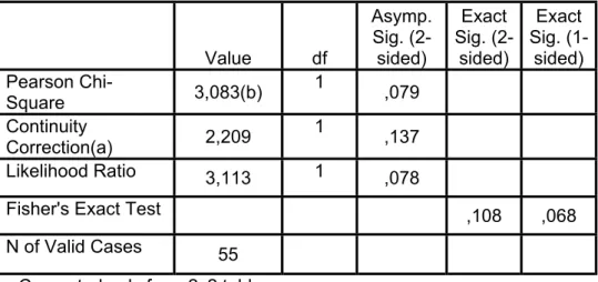
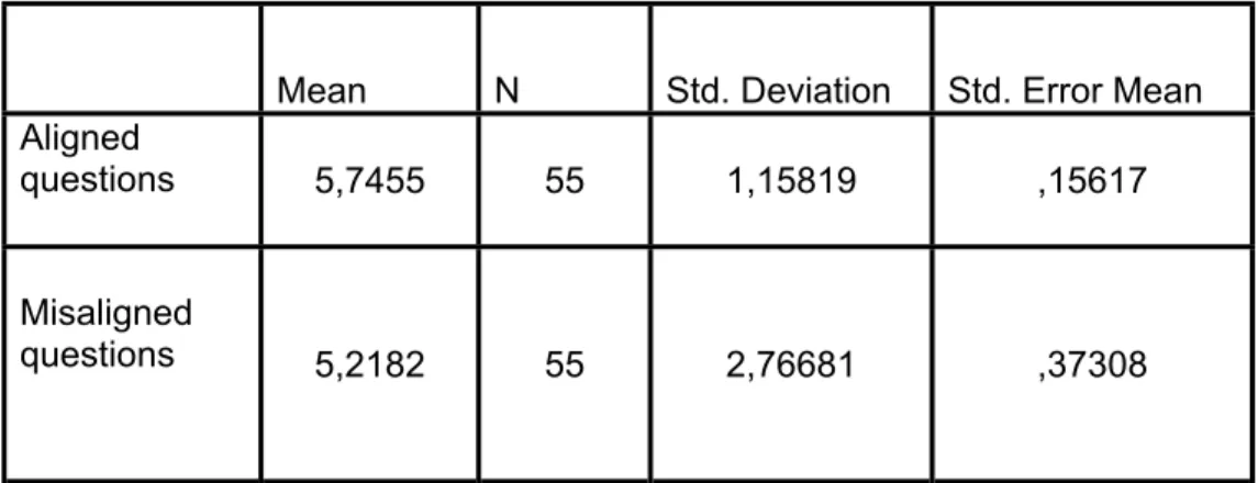
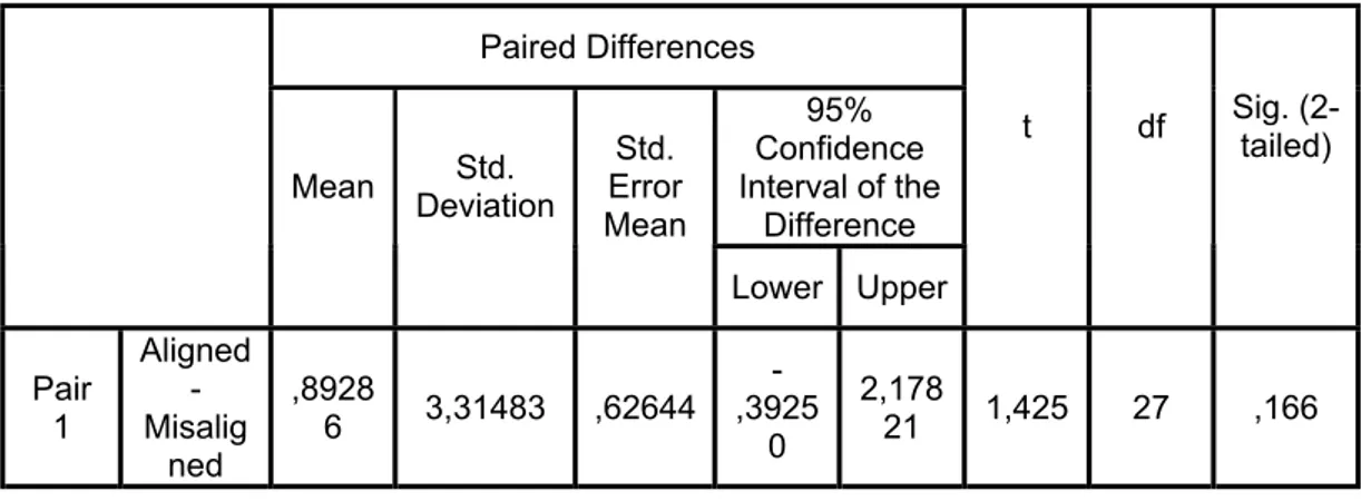
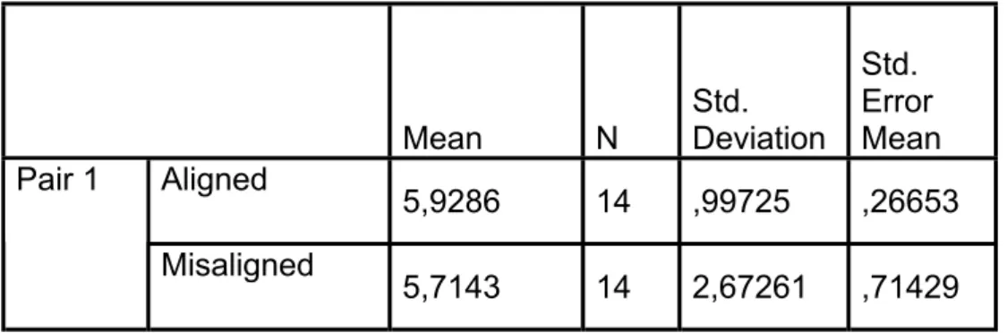
4.4.2. Aligned and Misaligned Questions……… 52
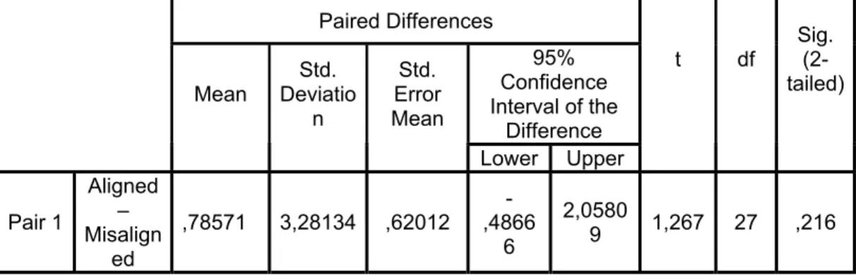
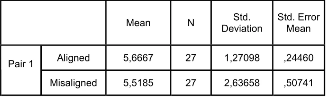
4.4.3. Aligned and Misaligned Questions in Good Sense of Direction (GSOD) Group……….52
4.4.4. Aligned and Misaligned Questions in Poor Sense of Direction (PSOD) group………. 53
4.4.5. All Female and Male Participants………. 54
4.4.6. GSOD & PSOD Group of Participants………. 54
5. DISCUSSION 56
6. CONCLUSION 61
APPENDICES 69
Appendix A……… 69
Appendix B……… 71
Appendix C……… 76
LIST OF FIGURES
Figure 2.1. A Schematic Bird’s Eye View of the Environment………... 13 Figure 2.2. Examples for Mapping Presentations……… 18 Figure 2.3. A Schematic View to Explain Aligned and Misaligned
Questions……….. 24
Figure 4.1. View of the Three Dimensional Space………48 Figure 4.2. Sample for Direction Circle Method Used in the
Experiment……….49
I. INTRODUCTION
1.1. Problem
Human spatial abilities have been investigated for many years. The reason of why some people are better than the others in wayfinding is still a mystery that is trying to be understood (Waller, 2005). One of the approaches in understanding individual differences in wayfinding process is to examine the human sense of direction in the context of environment and spatial cognition.
Developments in computer technology lead people to investigate the opportunities of virtual environments. Navigation through a virtual environment, and the factors that affect the cognition of people during
navigation were tried to be understood in order to make improvements in this subject. The sense of direction as a personal ability was accepted having an impact on people while navigating in an environment. Since the early
explanations of Kozlowski and Bryant in 1977, the common belief about the sense of direction is its positive relation with understanding the environment during a travel in a real world environment.
There is a widespread usability for virtual environments (VEs) nowadays. One can either navigate in a virtual campus or a virtual museum with a reasonable effort. Technological improvements provide people with many
opportunities for means of navigation in many areas from education to
entertainment by using VEs. In the present study, to better understand about the cognition of people in VEs during the navigation, the sense of direction as a personal trait has been investigated as well as the influence of gender and the learning style of the environment.
The style that people use to learn their environments may influence their accuracy about that environment. Waller, Montello, Richardson & Hegarty (2002) stated that the alignment effects can appear if spatial relationships are coded with respect to a special orientation. Making judgments related to viewing perspective and the 180° opposite direction from the learning direction is important to understand the memory for spatial layouts. Loomis, Lippa, Klatzky & Golledge (2002) stated that spatial updating “refers to the ability of moving a person to mentally update the location of a target initially seen, heard, or touched from a stationary observation point” (p.335).
For this reason, in the present study, the subjects who learn the whole environment with a fixed point of view, are expected to be more accurate in misaligned questions, which are designed 180° opposite direction from the learning direction of the layout. Since they have got the chance to observe the whole layout than focusing only one scene of the VE.
Navigation as a part of learning the environment is important in human life, both in real –world environment and in VEs. A better understanding of the spatial factors related to spatial navigation may lead people to use VEs more
beneficially, since there are some evidences that navigation strategies and behaviors were similar in VE and in real world environment (Darken & Georger, 1999). Moreover, male superiority over female about spatial navigation has still been a controversial subject. This may be a bias, which still needs to be researched.
1.2. Scope of the Thesis
Starting with the problem definition in Chapter 1, this study includes the importance of the navigation in virtual environments as well as in the real world environments. Due to the technological innovations in the computer technology, use of virtual environments has been diversified from
entertainment to educative purposes. For this reason, it is important to
understand the factors that have an impact on human spatial cognition during navigation. The ‘sense of direction’ as a spatial ability has been mentioned among other factors such as gender and influence of the learning style of environment.
Chapter 2 includes the literature review related to spatial cognition. The subtitles are as follows: wayfinding in spatial cognition, types of acquired spatial knowledge, mental abilities to obtain spatial knowledge, spatial
representation on cognitive maps, spatial reference systems, and orientation specificity in spatial cognition. Types of spatial knowledge are classified into three groups as landmark- based, route- based and survey knowledge. The information that comes from the landmark arrangement is also categorized as non- metric and metric spatial information. The mental abilities to obtain
spatial knowledge are grouped as ‘egocentric spatial updating’ and ‘perspective taking’. The cognitive maps which are called the ‘spatial
representations’ are classified as route maps and survey maps. Furthermore, the spatial reference systems that help us to learn the location of an object are explained under the titles of ‘egocentric’ and ‘environmental reference’ systems. Finally, the orientation specificity in spatial cognition is explained within aligned and misaligned questions.
Chapter 3 includes information related to spatial cognition and sense of direction. Starting with the meaning of the term ‘sense of direction’, the chapter continues with the explanations of ‘good sense of direction’ (GSOD) and ‘poor sense of direction’ (PSOD) that emphasize the importance of the sense of direction in learning an environment. Since there are some
arguments that sense of direction ability differs based on gender, the relation between gender and sense of direction is researched in the following section. Moreover, sense of direction as a self- report test, its validity and information about ‘Santa Barbara Sense of Direction’ (SBSOD) test, which was invented in 2002 by Hegarty, Richardson, Montello, Lovelace & Subbiah (2002), are explained in detail. Sense of direction in virtual environments (VEs) and advantages of working in VEs are included in the final section of the chapter.
The experiment is explained in Chapter 4. Starting with the research questions and hypotheses, the aim of the study is explained. Then, the participants and the task are defined. All the related question forms; Santa Barbara Sense of Direction (SBSOD) which is used to measure the sense of
direction ability of the participants, and the question forms which are
constructed to measure the relationship between the learning direction and the sense of direction ability of the participants in a VE are explained. Finally, the analysis and results of the experiment are given.
The present findings of the experiment and comparison with the findings and statements of the previous studies related to the subject are discussed in Chapter 5. Chapter 6 which is about conclusion summarizes the general findings of the research and includes further implications related to the experiment.
2. SPATIAL COGNITION
There is a dynamic process in knowing an environment.The current state of information is regularly updated, and supplemented(Golledge, 1999). Arthur and Passini (1992) defined cognition as “understanding and being able to manipulate information” (p. 33). Spatial cognition is defined as “the
internalized reflection and reconstruction of space in thought” (Evyapan, 1997, p.62). People’s way of gaining, storing and remembering information about location and arrangements of environment are the subjects of spatial cognition (Dogu, 1997; cited in Gifford, 1987). There is a strong relation between cognition and learning (Yavuz, 1998). Besides, “learning can be defined as an internal process that is different for every individual” (Demirbaş & Demirkan, 2003).
Spatial cognition is related with environmental knowing and understanding. In this perspective, this chapter includes, wayfinding in spatial cognition, types of acquired spatial knowledge, mental abilities to obtain spatial knowledge, spatial representations (cognitive maps), spatial reference systems and orientation specificity to make clear for understanding the human cognition system.
2.1. Wayfinding in Spatial Cognition
Environmental spatial abilities are involved in everyday activities such as navigation and wayfinding. Golledge (1999) defined navigation as “to
deliberately walk or make one’s way through some space” (p.6). It is mostly used in locating position in ships or aircraft as well as virtual environments. Passini, Pigot, Rainville, and Tetreault, (2000) explained wayfinding as, “a person’s ability of mentally imagining or representing a physical setting and of situating him or herself spatially within that representation” (p. 685). In wayfinding, there is a known destination that is not directly connected by a path. Issues such as use of landmarks, spatial updating of one’s location and identification of a frame of reference are important. Also, reaching a
destination either in a familiar or unfamiliar environment has an impact on wayfinding efficiency (Arthur and Passini, 1992).
Wayfinding is composed of three interrelated processes that are involved in reaching destinations. These are decision making which means “the
development of a plan or action”, decision execution which “transforms the plan into appropriate behavior at the right place in space” and information processing which “understood in its generic sense as comprising
environmental perception and cognition” (Arthur and Passini, 1999, p.25).
Lynch (1960) identified five elements of the physical structure that people used to construct environmental images during wayfinding: paths, edges, nodes, districts, and landmarks. Channels of movement are defined as paths, such as streets or walkways. Edges are barriers or boundaries and nodes
are focal points that consist of intensive activity to and form people may travel. Districts consist of intensive activity to and form people may travel. Districts consist of large sections that have recognizable, common perceived identity, homogeneity or character, which differentiates them from other areas. Landmarks are described as visible reference points that may be large objects or on a local scale.
These five elements are used to make the environments more clear and understandable for the users. By the way, it is possible to prevent stress related to the wayfinding which is a kind of obstacle that nobody wants to face with. Besides wayfinding strategy is important in determining the efficiency of the wayfinding process and it depends on the type of spatial knowledge used during the process.
2.2. Types of Spatial Knowledge
Golledge (1999) stated that while learning an environment, people either prefer to experience the environment through a travel process or learning it from an “over- looking vantage point” or by some symbolic tools such as maps or photographs (p. 9). According to the theory that has been effective for the last few decades, Janzen, Schade, Katz and Hermann (2001)
mentioned that when people gain information about the spatial structure of a new environment, there are some stages available for them. Firstly, people pass through a stage of ‘landmark knowledge’. There are few unconnected landmarks that are stored in the memory. Then, people represent a single familiar route in memory where landmarks and a connecting route are
memorized. This is the way people gain ‘route knowledge’. After, people can integrate new knowledge as soon as they learn other routes. This is the stage of ‘survey knowledge’. This kind of knowledge is the most complex one and it gives the possibility for its users to navigate on new paths. Even
though some recent studies suggest that people can gain the survey knowledge without passing through the route knowledge stage, they found that participants were integrating route knowledge into survey knowledge.
Navigation is an important human activity which is a kind of process related with directing a person’s locomotion to reach his/ her target point. It relies on “sensory or verbal guidance or on an “internalized representation of an environment” (Gaunet, Vidal, Kemeny and Berthoz, 2001, p. 409). Janzen et al. (2001) stated that there are four factors that are effective in deciding the navigational strategy of an individual. These are the styles of representation of the environment, the complexity of the environment, gender and the kind of visual information provided in the environment.Gaunet et al. (2001) stated that, visual information can be gained by active (self- initiated movement) exploration of a layout or by passive (pre- recorded tour) displacements. They stated that active exploration is found to be important in determining how vision is used in spatial knowledge. Memory of spatial layout or “relative positioning of objects” was better for active explorers, on the other hand object memory had better for passive exploration in a VE (Gaunet et al., 2001, p.410). Gaunet et al. (2001) stated that no difference was found in a previous study between active and passive experimental groups about pointing error in a VE (cited in Wilson, Foreman, Gillet and Stanton, 1997).
Even though the active explorers used joystick to control the displacement, the affect of the visuo- motor interaction had little effect on scene recognition (Gaunet et al., 2001).
The following section includes the landmark- based, route-based and survey knowledge to explain the types of the spatial knowledge which are important for people in navigating and learning the spatial layout of an environment.
2.2.1. Landmark- based Knowledge
In order to establish a place memory, people require using landmarks. This process is known as landmark- based navigation. Manipulating the properties of landmarks or their geometrical relationships is commonly practiced by investigators. People usually decide their location by looking for landmarks which are collinearwith the viewpoint from an external representation.
Therefore, linear landmark array seem especially easy to use and remember (Waller, Loomis, Golledge and Beall, 2000).
In the mapping process, the coordination of landmarks is very significant. Also, in establishing the spatial frames of references, landmarks are
determined and crucial (Péruch and Lapin, 1993). To read the space and to give a route instruction people may take the landmarks as reference
(Başkaya, Wilson and Özcan, 2004). It is possible to learn identification for landmarks as getting experience from the new surrounding
Landmarks are generally perceivable because of their visibility in form, being strange in shape or having sociocultural importance. Landmarks are used to organize the spatial information in a layout. For this reason, they have an important role in cognitive maps (Golledge, 1999).
There are three types of landmarks which are classified as visual, cognitive and structural landmarks. A visual landmark is noticeable because of its visual properties. A cognitive landmark is noticeable because of its typical meaning, and a structural landmark is important because of its location or role in the space (Sorrows and Hirtle, 1999).People using landmarks have obtained better route knowledge in a VE (Parush and Berman, 2004). Besides, major landmarks are accepted as one of the key architectural elements that generate legibility in real world environment (Doğu and Erkip, 2000).
In VEs, landmarks are also important and should be designed carefully. Vinson (1999) stated that VEs should be easily navigated and using landmarks effectively is important like the demands of the real world
environment. Understanding the role of landmark also helps VE designers in forming cognitive maps. Several landmarks should be present in a VE. There are some features that the landmarks in a VE should possess. Each
landmark should be noticeable with its height, complex shape, and bright exterior and large visible signs. Landmarks should be chosen from concrete things rather than abstract ones to make them more recognizable.
should be distinguishable from nearby objects and other landmarks in order to easily prevent any confusion or wrong navigational action in a VE. The sides of the landmarks should be differentiated from each other to help the navigators in deciding their orientation. The distinctiveness of a landmark can be increased by using other objects nearby. Landmarks should carry some common elements that separate them as a group from the other virtual objects. These are the properties related with the appearance of landmarks located in a VE. Landmarks in VEs can be designed as having similar properties with the real world landmarks. In this way, the experiences of the real world navigators can be transferred to the virtual world. Moreover, the placement of landmarks should be well defined. Landmarks should be placed on major paths and at path junctions. By this way, the landmark could be more memorable.
There are two kinds of spatial information that is determined by the arrangement of landmarks. These are non-metric and metric spatial information (Waller et al., 2000).
2.2.1.1. Non-metric Spatial Information
This type of spatial information is related with those spatial relationships including “topological or projective” relationships such as concurrence, betweeness, and adjacency, as well as “sense” relationships such as left/ right or clockwise/ counterclockwise” (Waller et al., 2000, p. 335). There is a relation between adjacency in human place learning and non- metric spatial
information. Hermer and Spelke (1996) showed that people tend to use adjacency relationship to recall the position of the target (Waller et al., 2000).
2.2.1.2. Metric Spatial Information
The second type of information obtained from a landmark arrangement is called ‘metric spatial information’. It includes quantitative spatial relationships that demand the concept of congruence. The spatial relationships are
included the relative distances from the viewing location to other landmarks and the angle differences that are formed by the viewing location and pairs of landmarks (Waller et al., 2002) (see Figure 2.1). In the figure, it was
supposed that participants walked to a target location (shown as star) and learned their location relative to three distinctive landmarks (shown as circles). Information about the distances between the target and the
landmarks (d1, d2, and d3) and information about the bearing differences to each of the landmarks (α1, α2, α3) were presented (Waller et al., 2000).
Figure 2.1. A schematic bird’s- eye view of the environment (Waller et
Waller et al. (2000) stated that the mechanisms of using these two kinds of information are not still clear. Some studies suggested that distant
information is not reliable and significant. Angle differences are preferable rather than distances in computer and animal models of piloting. On the other hand, for humans, distance information is more significant for place learning. When people learn locations, they may be affected from metric distances. Also, it is suggested that “right and straight angles are more easily encoded in memory than other kinds of angles” (Waller et al., 2000, p.350).
2.2.2. Route- based Knowledge
Golledge (1999) stated that route- based environmental learning could be one of the most preferred learning style of many people while learning their environment. Landmarks could be the following properties which may be used for orientation in an environment. Rossano, West, Robertson, Wayne and Chase (1999) stated that route knowledge means “knowledge about the movements necessary to get from one point to another” (p. 101). People tend to divide the route while learning it and they do this process to organize “along- the-route” information (Golledge, Gale, Pellegro & Doherty, 1992, p. 225). “Route knowledge is a procedural description of the route between points in the environment” (Parush and Berman, 2004, p. 377). Schmitz (1999) stated that route knowledge includes important landmarks as well as the routes which connect the landmarks and the order of route turns in wayfinding. Route knowledge also includes learning of a sequence of instructions about how to get from a location to the next one and it allows
showing spatial information in an egocentric perspective (Bosco, Longoni & Vecchi., 2004).
2.2.3. Survey (layout, configurational) Knowledge
Survey knowledge consists of metric and relational information about landmarks and paths; distances, bearings and the configuration of objects which may be represented as if seen from bird’s eye view (Cornell, Sorenson and Mio, 2003). Rossano et al. (1999) stated that survey knowledge has relation with perception of the layout and “interrelationships of the elements contained therein” (p.101). Comparison as route knowledge, survey
knowledge presents a more understandableand flexible understanding of the spatial characteristics of a large- scale environment (Waller, Hunt and Knapp, 1998). Parush and Berman (2004) stated that survey knowledge includes all elements’ in the layout and the spatial relationships surrounded by these elements in the environment. Rossano et al. (1999) stated that survey knowledge is created piece by piece from the elements of route knowledge, when it is gained from direct experience.
Rossano et al (1999) also stated that, it may be possible to obtain survey knowledge more quickly by using computer models. Computer models experience may share common features with map usage and direct
experience. Since direct experience leads to well developed route knowledge and map subject leads to better survey knowledge, it was expected that computer model experience leads to well developed route knowledge. In their study, it was found that there was no difference between the map and
computer- model users in using the route knowledge. However, there was an important improvement in the computer- model users in obtaining the survey knowledge.
Considering the relation between sense of direction (SOD) and survey knowledge, Prestopnik and Roskos- Ewoldsen (2000) stated that, SOD is related to use of survey strategies rather than route strategies. In addition, Hegarty et al. (2002) stated that there is a relation between the ability to point to landmarks and SOD.
2.3. Mental Abilities to Obtain Spatial Knowledge
There are two types of mental abilities to obtain spatial knowledge from navigation through an environment. These are egocentric spatial updating and perspective taking (Waller, 2005). Both abilities affect people’s ability to point unseen locations in a familiar environment (Waller, 2005).
2.3.1. Egocentric Spatial Updating
Egocentric spatial updating “refers to the ability of a moving person to
mentally update the location of a target initially seen, heard, or touched from a stationary observation point” (Loomis et al., 2002, p.335). While a person moves through an environment, he/she keeps path of the changing
relationships between him/herself and the external objects by using spatial updating and “the update scale requires people to account for the apparent change in position of a target object that results from simulated self- motion” (Waller, 2005, p. 247).
2.3.2. Perspective Taking
Perspective taking is “the ability to infer spatial relationships that one has not directly experienced” (Waller, 2005, p. 3). For example, a person having ground- level experience can imagine what the environment looks like from a bird’s eye perspective. It is also thought to be related with the ability to obtain a flexible ‘survey’ representation of an environment (Waller, 2005).
2.4. Spatial Representations (Cognitive Maps)
Cognitive maps are defined as knowledge of places, and cognitive mapping represents issues to construct spatial relations among such places. They are the ‘internal representation of perceived environment’ (Golledge, 1999, p. 6). Cognitive maps are the mental representations that include survey
knowledge of a familiar environment (Cornell et al., 2003). “It is a mental device and store which helps to simplify code and order the complex world of human interaction with the environment” (Kitchin, 1994, p. 2). Cognitive map means “an elaborated kind of spatial knowledge where detour finding is used as an indicator” (Janzen et al., 2001, p.149). Cognitive map can be observed with external representations such as “sketch maps, pictorial drawings, verbal descriptions, modeling and other methods of spatial manipulations” (Passini, 1984, p. 36). These external representations can be developed and categorized by people (Demirbaş, 2001) (See Figure 2.2)
Figure 2.2. Examples for mapping presentations (Kaplan, S. and Kaplan R.,
Cognitive mapping is the mental process leading to a cognitive map (Arthur and Passini, 1992). “Cognitive mapping is a process composed of a series of psychological transformations by which an individual acquires, stores, recalls, and decodes information about the relative locations and attributes of the phenomena in his everyday spatial environment” (Kitchin, 1994, p.1). There are two types of cognitive maps which are called route maps and survey maps.
2.4.1. Route Maps
Route maps receive their names from their clearly seen organization. They are simply linked collection of landmarks. This is a kind of cognitive map which is “organized along a path in which one landmark follows another...It mirrors the way information is acquired and the way it will be used”
(Golledge, 1999, p. 358). There is an analog of one mode of information processing for the sequential structure of route maps, which means information comes in a natural sequential flow. There is no full range of spatial relationships available in route maps. Route maps are involved in proximity and order which are necessary for planning a journey (Golledge, 1999). Waller et al. (1998) also stated that landmarks, which are located in a route, can be linked together and this kind of knowledge is called ‘route representation’.
2.4.2. Survey Maps
A survey map is generally considered to be “more abstract and directly visual in character” (Golledge, 1999, p.361). Survey map is related with survey representation that appears to give a person the ability of imagining an environment as if looking it from a survey viewpoint. The structure of survey maps includes a different form of information processing than the route maps. The scene is the main unit of the survey map structure, whereas, the landmarks serve as the main unit of route maps. In survey maps, no
transformation is necessary; information is stored in the operated format. Knowing the place of landmarks that are relative to each other in a particular environment, an individual needs no more recall of appropriate relative positions (Golledge, 1999).
An individual understands the spatial relationship between various landmarks in an environment in a survey representation. Survey representations give possibility to reach the spatial information without the need of orientation (Waller et al., 1998). There is an overview of spatial layout and an extrinsic frame of reference for survey representations. On the other hand, there are a number of important landmarks attached by route representations (Pazzaglia and De Beni, 2001). Besides, types of cognitive maps, the spatial reference systems should also be understood. Since reference systems are necessary to make identifications about the locations of objects (McNamara, 2002).
2.5. Spatial Reference Systems
To preserve the remembered locations of objects, people need to use spatial reference systems. Without providing a frame of reference, an individual can not identify or report the position of an object (McNamara, 2003). Mou and McNamara (2002) stated that without establishing a frame of reference, it is impossible to define the location of an object. As an example, the latitudes and longitudes are used to define the location of objects on the surface of the earth. In the same manner, to specify the remembered location of objects, human memory system must use frames of reference.
There is a significant difference between form perception and spatial memory. That is, figures in the frontal plane are oriented in a space with a powerful reference axis; gravity. On the other hand, the locations of objects are defined in the ground plane which does not have privileged axes. For this reason, it is assumed that the dominant signal in spatial memory is
egocentric experience. When a new environment is learned, the locations of objects are described in terms of a reference system intrinsic to the layout itself. Axes intrinsic to the objects are chosen to represent location and orientation. These axes are chosen on the foundation of egocentric experience, spatial and non- spatial features of objects and cues in the surrounding environment (Mc Namara, 2003).
There are two types of spatial reference systems. These are named as egocentric reference systems and environmental reference systems.
2.5.1. Egocentric Reference Systems
“Location is specified with respect to the observer” in egocentric reference systems (Mou & McNamara, 2002, p.162). McNamara (2003) mentioned that “Egocentric reference systems specify location and orientation with respect to the organism, and include eye, head, and body coordinates” (p.174). The process of locating oneself in space includes both egocentric viewpoints and exocentric information about the spatial layout (Péruch and Lapin, 1993).
2.5.2. Environmental Reference Systems
“Location is specified with respect to the objects other than the observer” in environmental reference systems (Mou & McNamara, 2002, p. 162).
McNamara (2003) stated that “Environmental reference systems specify location and orientation with respect to elements and features of the environment, such as the perceived direction of gravity, landmarks, or the floor, ceiling, and the walls of a room” (p. 175).
2.6. Orientation Specificity in Spatial Cognition
People have learned many layouts either visually, tactilely, by navigation or virtual reality. Performance of the participants is found to be the higher in the orientations aligned with the intrinsic axis of learning (McNamara, 2003).
Mc Namara (2003) mentioned that the initial examinations of spatial
reference systems were done in a laboratory (Diwadkar & McNamara, 1997; Roskos- Ewoldsen, McNamara, Shelton, and Carr, 1998; Shelton &
McNamara, 1997). For example, in a study, participants are required to learn seven objects in a room and then asked to make judgments about these object’s locations in a computer environment (Shelton and McNamara, 1997).
The qualities of memorial representations of space are much of the current interest in spatial cognition. One property of spatial representations involves the orientation specificity of spatial memory for large spaces and layouts (Waller et al., 2002).
Waller et al. (2002) suggested that there are series of studies conducted by Presson and his friends about it (Presson, DeLange and Hazelring, 1987, 1989; Presson & Hazelrigg, 1984). They asked participants about four kinds of points from a single location and requested to make judgments either on the same orientation or 180° different orientation from the viewpoint. There were four locations labeled 1 to 4 from the fixed viewpoint that is presented. The aligned questions were formed such as; “point to Location 3 as if
standing at location 1, facing toward Location 2” and misaligned questions were formed such as “point to Location 2 as if standing at Location 3, facing Location 4). (Waller et al., 2002, p. 1052) (see Figure 2.3).
Figure 2.3. A schematic view to explain aligned and misaligned questions
(Waller et al., 2002, p. 1052).
Two types of questions called aligned and misaligned prepared to evaluate how participants learn the layout either from the same orientation (0°) of the viewpoint or 180° different orientation for the viewpoint (Waller et. al., 2002).
2.6.1. Aligned Questions
Waller et al. (2002) indicated that, in aligned questions, “participants were asked to point one location as if they were facing the same direction of learning” (P. 1052).
Mou, McNamara, Christine and Rump (2004) suggested that if the participants learn the layout from the viewing position 0°, this is called aligned. Whereas, if the viewing position is different than 0°, then called misaligned. For the aligned view, the imagined direction is equal to 0°. This means the learning direction is equal to the imagined direction. According to
the study of Mou et al. (2004) participants were better at pointing
performance when the learning and imagined direction were same or parallel.
Mou and McNamara (2002) stated that in one of the study, the layout of the objects in a room was learned from two stationary points of view, one of them is aligned and the other one is misaligned with environmental frames of reference. Performance of the participants’ judgments of relative direction showed that the aligned view was represented in the memory; whereas the misaligned view was not represented.
2.6.2. Misaligned Questions
Waller et al. (2002) pointed out that, in misaligned questions, “participants were asked to point one location as if they were facing in the opposite direction as they were during learning” (p. 1052).
Participants were significantly more successful in aligned questions instead of misaligned questions, when they learned a layout from its representation on a small map. On the other hand, no alignment effect was found, if the learned place was large enough such as 3.6 X 3.6 m. This means that, the participants were found successful in misaligned questions as well as the aligned questions in large scale environments (Waller et. al., 2002).
Orientation dependence was regulated by the layout size. Participants made estimations about relative direction using their memories of layout after learning the layout. The layout size was an important property that shows the difficulty of aligned and misaligned judgments. Aligned judgments were more
accurate than misaligned ones, if the learned layout was small. However, when the learned layout was large, the difference between two alignments was eliminated or reduced (McNamara, 2003).
In general, large spaces surround the viewer and therefore they make the participant a part of the surrounding. Because of this, these spaces require to be coded by means of a reference system. Spatial relationships are coded freely from a particular orientation. No orientation is selected in memory and no alignment effect will appear. However, when spatial knowledge is
obtained from a small nonnavigable object like a map, the viewer himself is not a part of the learned surrounding. The alignment effects are able to appear, when the spatial relationships are coded with respect to a specific orientation. On the contrary, some of the researchers (Roskos- Ewoldsen et al., 1998, Presson et al., 1989) stated that both small and large scale stimuli produced alignment affects (Waller et al., 2002).
Finally, after introducing some information about terminologies used in the field of spatial cognition, it would be easier to understand how the human cognition systems work in terms of environmental learning and sense of direction within the context of spatial cognition. Therefore, the next chapter includes information about the concept of ‘sense of direction’ as well.
3. SPATIAL COGNITION AND SENSE OF DIRECTION
Kozlowski and Bryant (1977) stated that sense of direction is regarded as “an awareness of location or orientation” (p.590). Golledge (1999) said that people use a “self- referencing system to develop a sense of direction while wayfinding” (p.33). According to Sholl, Acacio, Makar & Leon (2000), sense of direction is “the knowledge of the location and orientation of the body with respect to the large stationary objects, or landmarks, attached to the surface of the earth” (p.17). Sense of direction is related with an ability to
discriminate fine- grained environmental cues, memories of locations while maintaining a cognitive map, and strategies for learning a route (Cornell et al, 2003).
Sense of direction is significant when a person makes a decision about an unseen but known destination. Providing information for that kind of situation is related with both sense of direction and the correctness of the
representation of faraway features. Body axes of the individual maintain a reference frame to which all directed motor- activity is referred. Therefore, the individual is tied by position vectors to objects in the visual field. As the
individual moves, spatial updating occurs with reference to this system. This systems works in cases that vision does not occur as well (Golledge, 1999).
According to Sholl et al. (2000), a behavioral measurement of the sense of direction is “the accuracy of people’s pointing responses to familiar but non- visible landmarks in the surrounding environment” (p.17).The ability to point unseen locations is accepted as a measurement. In pointing to unseen location exercise, participants were wanted to pretend that he/ she was standing on a location (X), and was facing to the other location (Y). Then, it was asked to point the relative direction of the buildings which were listed, by putting mark to the outside of the given circle (Kozlowski and Bryant, 1977).
Sense of direction is related with direction, distance and time estimation abilities which have important impacts on orientation abilities, since it was suggested that there was a significant relation between self reports of sense of direction and having distance estimation ability. Being more accurate at distance or having a better score at sense of direction means, smaller pointing error (Kozlowski and Bryant, 1977).
Prestopnik and Roskos- Ewoldsen (2000) mentioned that sense of direction is a key factor for anticipating wayfinding ability.Sense of direction may be important when the wayfinders are required to update their position during movements in unfamiliar environments. This statement is not supported by psychometric assessment because it was not found very successful on standard mental rotation tasks which are object- centered rather than environmental frame of reference (Heth, Cornell and Flood, 2002).
3.1. Good Sense of Direction (GSOD) vs. Poor Sense of Direction (PSOD)
People show differences while they are navigating through new
environments. These differences are related to the participants’ attitudes of sense of direction. People who reported themselves as having good sense of direction are expected to carry out following activities: actively explore their environment, can give and follow directions, recall new routes and give attention to details of a new environment. In contrast, people with poor sense of direction feel worry about loosing their way, are lost in new cities and buildings and feel anxious about becoming lost (Sholl et al., 2000).
People who have good sense of direction are good at remembering of indoor locations, successful at imagining spatial relationships, and pointing to
landmarks when assuming a viewpoint that was not aligned with the
participant’s forward facing. Moreover,a person with good sense of direction looks for areas containing landmarks and can use this information at
intersection points of the routes. People with good sense of direction can orient a mental representation as a configuration of landmarks to
complement a viewing layout (Cornell et al, 2003).
Sense of direction has relation with the ability to coordinate egocentric frames of references mentally that is important while updating ones position in unclear environments (Cornell et al, 2003). The better sense of direction means, one has better orientation ability. People who reported themselves as having good sense of direction were better than the poor sense of direction
group about some issues such as, “giving or following directions (whether written or oral), remembering routes while passengers in cars, and
remembering written directions to a place” (Kozlowski and Bryant, 1977, p.592). Moreover, people with good sense of direction were superior in pointing unseen goals to people with poor sense of direction in a familiar environment. The ones with good sense of direction showed improved accuracy in their representation of the place. On the other hand, participants with poor sense of direction showed no improvement in accuracy. For this reason, it can be stated that improved orientation for those who have good sense of direction, is related with a conscious effort and repeated exposure to a layout. In addition, the ones with good sense of direction like reading maps, giving directions, trying to recall details in a new layout and give importance to find new routes to places when driving, rather than the ones with poor sense of direction (Kozlowski and Bryant, 1977).
Furthermore, the ability to use several strategies in a flexible way affects the wayfinding performance of the participant. In a study, the participants that rated themselves with poor sense of direction experienced more difficulty in using flexible strategies in comparison to the ones with good sense of
direction (Kato and Takeuchi, 2003). People with poor sense of direction feel worse and more anxious when they are losing their way than people with good sense of direction. In addition, people with good sense of direction skills can point north better than people with poor sense of direction. For example, the one who has good sense of direction is able to point the local shopping center more accurately than the one who has poor sense of direction
(Kozlowski and Bryant, 1977). A person with good sense of direction may be good at looking for areas that contain landmarks. He/ she is able to use that ability to direct actions on routes. Good sense of direction can maintain a reliable reference bearing during the navigation (Heth et al., 2002).
Self- reports of sense of direction that is decided by the accuracy of mental maps of the environment, maintain a simple measure of spatial orientation. Sense of direction “has an active place in people’s self- concepts” (Kozlowski and Bryant, 1977, p. 597). The one with good sense of direction gains ‘self- esteem’ from his/ her sense of direction. For example, people with good sense of direction possess intrinsic motivations such as using mental map effectively, using a route map to from a survey map and fulfillment of solving cognitive games. Whereas people with poor sense of direction are more likely to lose their way and feeling disorientation in places such as subway or theaters. They have intense emotional disappointment which follows
disorientation (Kozlowski and Bryant, 1977). A good sense of direction was found useful for wayfinding and orientation. Good sense of direction was rated higher than poor sense of direction in conventional representations such as maps, verbal and cardinal directions which were found to be related to taking shortcuts and making navigation in an unfamiliar environment. In addition, when environmental knowledge is limited, a good sense of direction was accepted significant, for example, when the landmarks’ or a building’s location must be imagined (Cornell et al., 2003).
3.2. Gender Differences
Several studies (Denis; 1996, De Vega, 1994, Linn and Petersen, 1985) on the sense of direction and wayfinding ability have shown significant
differences between individuals that are based on gender issues (Pazzaglia and De Beni, 2001). Gender issue can be examined related to socio- cultural factors, spatial performances, used strategies, sense of direction ability and the role of virtual environments within spatial cognition.
3.2.1. Socio- cultural Factors
Schmitz (1997) stated that gender differences in environmental strategies can be explained as a result of different levels of anxiety and fear of girls and boys. The strong reliance on landmarks for female participants can be
explained with the effort of feeling more secure through environmental knowledge.
Gender differences might occur because of experiences with a different set of prior activities which may go back to childhood. For example, studies have shown that for boys and girls, approval of the parents’ maintain different activity spaces. In addition, toy play is another feasible area for the beginning of gender differences (Malinowski and Gillespie, 2001).
Cultural demands and expectations about travel may influence the men’s and women’s spatial behavior. Although the constraints of cultural behavior are minimal in early age, boys and girls behave differently. For example, “1-year- old boys move farther from their mothers and stay away longer when playing
than girls do” and therefore there should be more studies to understand the relation of gender and spatial behaviors (Dabbs, Chang, Strong and Milun, 1998, p. 96).
Moreover, there may be a gender bias related to the spatial abilities. Montello, Lovelace, Golledge & Self (1999) stated that to compensate different modes of getting and employing spatial information, both genders could be trained and educated. Bosco et al. (2004) claimed that more recently, the importance of socio- cultural factors were highlighted on
women’s performance in visuo- spatial tasks to show the impacts of training and cognitive strategies since gender differences could be reduced by an appropriate educational training.
3.2.2. Spatial Performances
Cornell et al. (2003) found that males in western societies are more confident in general orientation abilities and more accurate at pointing to environmental landmarks than women. In addition, there was a difference between male and female participants in making estimations from imagined vantage points. Males were faster than females while making verbal estimations of target locations. However, females behaved more carefully, lost more time and made more errors in making estimations and this was stated as the lack of confidence in females. On the other hand, there was no evidence which showed that females were poor in wayfinding tasks. This means that, on some of the tasks, there was no gender difference in performances. For example, even though females were slower than males, there was no
significant difference between genders in making estimation from real vantage points. Moreover, there were no gender differences in reports of shortcutting, which includes the configuration of the original route, and in reports of methods, which involves the configuration of buildings and grounds where females tend to use survey representations.
Montello et al. (1999) found that males used cardinal direction terms
significantly during the verbal description of a campus and they made fewer errors about estimating the campus- route distances. On card rotation test, males got higher scores. Besides, males reported higher spatial ability and preferred to use more metric spatial terms, whereas females used more maintenance terms, which were generally composed of non metric- distance terms and a little fewer metric terms, to make verbal description of the route. Women were better in object- location memory task and were better to recognize the landmarks on the route.
Lawton (1996) stated that spatial anxiety has a negative influence on the accuracy of pointing task. This means the more the spatial anxiety, the less the accuracy at pointing task and less confidence about the responses. Lawton and Kallai (2002) found that women reported less personal safety than men did. This may affect the women’s wayfinding behavior such as the route planning. Women may concern possible dangers, which may be resulted from getting lost in an unfamiliar environment more than man.
3.2.3. Sense of Direction
Prestopnik and Roskos- Ewoldsen (2000) stated that gender difference is controversial in spatial ability being in favor of men. However in the sense of direction, there has still been argument and whether there is a gender
difference or is not clear yet.
Females reported lower scores related to their sense of direction ability compared to males (Cornell et al., 2003).Devlin and Bernstein (1995)
mentioned that men were more confident in their ability to find their way and made fewer errors in a computer simulation task than women.
Sholl et al. (2000) stated that people with poor sense of direction have more restricted interactions with the environments. Understanding the cognitive factors which offer sense of direction is significant. Even though female participants tend to report a poorer sense of direction than male participants, this does not relate to “other types of spatial intelligence such as mental rotation ability” (Sholl et al, 2000, p.17).
3.2.4. Used Strategies
Schmitz (1999) stated that gender differences in environmental knowledge may be related to the differences occurred in strategies of the two genders which women tend to use landmark- based knowledge, whereas men prefer a more Euclidean or configurational strategy. Kato and Takeuchi (2003) also stated thatmales preferred to use Euclidean spatial cues such as direction and distance, whereas women preferred to memorize landmark cues.
Montello et al., (1999) stated that females rely more on route strategy whereas, males on survey strategy that is related with metric knowledge of distances and directions, especially cardinal directions. Moreover, in
Silverman and Eals (1992)’s study, there was a female superiority for recognizing and locating objects on a sheet of paper that had been seen before, which is related with picture stimuli or environmental spaces, was confirmed with the findings of Montello et al. (1999). Schmitz (1999) also stated that males were better in directional accuracy, whereas females were better in landmark recognition.
Bosco et al (2004) pointed out that men and women used different strategies to conduct the orientation tasks. On the other hand, enough training could reduce or eliminate the gender effects in spatial orientation. Postma, Jager, Kessels, Koppeschaar and van Honk (2004) found that there was no
significant gender difference for the details of the remembered route which means recognizing landmarks were similar for both genders. Parush and Berman (2004) stated thatfemale participantshad shorter orientation response time when they navigated with landmarks.
O’Laughlin & Braubaker (1998) also mentioned that, there was not
significant gender difference found in mapping task related with a furnished and unfurnished home environment, which were recorded on video tape. Rather, the accuracy of mapping task of the home environment was increased when landmarks were provided for both genders compared with minimal landmarks condition.
3.2.5. The Role of Virtual Environments
Sandstrom, Kaufman and Huettel (1998) stated that even though both genders developed valuable strategies, males had got superiority in VE navigational task. The effect of joystick experience was thought to be an important reason related with the ability differences of genders. Janzen et al. (2001) mentioned that males’ greater experience in computer games
maintain a gender difference during the navigation through virtual
environments. According to their study, there was a gender difference in terms of using joystick. Using joystick and playing computer games were reported more by men. However, this situation did not assist men to solve the detour task with fewer errors and in shorter time.
Devlin and Bernstein (1997) mentioned that males were faster than females in indicating the paths to follow for the simulating mapping task, and females reported more frustration than males did for competing in the experiment. Moffat, Hampson and Hatzipantelis (1998) also found that males were better than females about spatial route learning in their research which was
conducted by using a virtual maze. Male participants learned the new route of the simulated maze more quickly and did fewer errors than female
participants did.
Waller et al. (2001) stated that there is a gender effect on spatial knowledge possession in VEs. According to their findings, there is disorientation of women in virtual mazes. Compared with men, women had more errors. It is suggested that, understanding the spatial characteristics of VEs may be
more challenging for women than men. Lawton and Kallai (2002) indicated that when landmarks were removed during training in a computer- simulated maze, men participants were faster than female participants. However, when the landmarks were stable, no gender difference was found.
Waller (2000) mentioned that gender influences the strategies of obtaining spatial knowledge and accuracy of the spatial knowledge. In
psychometrically–evaluated spatial abilities, gender difference is stressed. There is a slight or moderate favor on male advantage in these spatial tasks. Moreover, gender differences in spatial knowledge possession which is obtained from VEs desktop may reflect greater gender differences than the real- world cases. This distinction may be related with differences in the abilities that are demanded to interact with computers. There can be much smaller gender difference in the real world tasks than identical spatial tasks on the VE.
In terms of gender differences, the variables related with computer technology are; the attitude towards computers, prior experience with computers, and the ability to learn new or unusual computer interfaces. However, it stayed as a powerful predictor of these abilities. It is also claimed that if the spatial abilities are trained, gender differences may be reduced (Waller, 2000).
3.3. Sense of Direction as a Self- Report Test
The first self- report measure was introduced by Kozlowski and Bryant in 1977. They asked the subjects the question, “How good is your sense of direction?” (p. 591). The subjects rated their sense of direction on a seven point scale from poor to good. Psychometric measures were considered as weak predictors of environmental spatial ability and self- reporting measures were found to be a promising approach (Hegarty et al., 2002). In addition, the self- report sense of direction (SOD) was found to be highly correlated with the performances of environmental spatial tasks (Prestopnik & Roskos-Ewoldsen, 2000; Sholl et al, 2000). Hegarty et al. (2002) pointed out that “SOD is primarily related to the ability to mentally align egocentric and
environmental reference frames” (p. 428, cited in Sholl, 1988 ). For self- rated of sense of direction, predicative validity has objective measures of spatial navigation ability, such as the ability to imagine a perspective of the
environment that is different from the actual one, recognition of landmarks or ability to integrate path information (Sholl et al., 2000).
Santa Barbara Sense of Direction (SBSOD) is a self- report scale of
environmental abilities that is developed by Hegarty et al. (2002). SBSOD is a self report scale, that requests from the participants to rate themselves about their navigation and wayfinding skills. A correlation was found between self report sense of direction and the performance measures of large- space spatial tasks, such as imagining oneself reoriented in a known environment and learning spatial layout. The self report SOD also reflected the ability to carry out the tasks characteristics at the environmental scale of a space
rather than the vista space. It was predicated that SBSOD was highly correlated with measures of environmental knowledge obtained from direct experience. Also, it was found that different learning styles or media, such as maps, video or virtual environments (VEs) were significantly correlated with the acquired knowledge (Hegarty et al., 2002).
About judgment of self ratings of sense of direction, Heth et al. (2002) mentioned that the people, who have successful wayfinding history, also have a good sense of direction. Moreover, Heth et al. (2002) reported that self ratings of children were found to be higher than adults’. Adults were more realistic than children and they were reasonably good at evaluating
themselves about sense of direction.
When people were rating their SOD as ‘good’ or ‘poor’ in SBSOD, they were building their judgments on environmental tasks such as, wayfinding,
remaining oriented in an environment, learning layouts, using maps to navigate, and giving and following directions. Most of the things that
burdened on the sense of direction factor included ratings of the individual’s own satisfactory level on tasks that rely on survey knowledge of
environments, whether stored or generated during task performance (Hegarty et al., 2002).
People’s perceptual motor systems may have an effect at different scales of space. Therefore, paper and pencil tasks were conducted to evaluate
in two dimensional and three dimensional spaces (Montello et al., 1999). Self report sense measures such as sense of direction questionnaires had better performance to measure the environmental spatial abilities.“ People’s
performance on paper- and- pencil tests of spatial ability is typically able to account for only about 5% of the variance in their ability to learn or find their way in large – scale environments” (Waller, 2005, p. 244).
People with good sense of direction were better at aligning themselves within imagined frames of reference. This was important for the individual to update his/ her position during movements in unfamiliar or not clear environments. Psychometric evaluation of mental abilities does not maintain these
propositions. For example, people who report themselves as having good sense of direction were not successful at standard mental rotation tasks. Since these tasks demand an object- centered frame of reference rather than an environmental frame, sense of direction may not influence the
performance of the participant at this task (Heth et al., 2002).
3.4. Sense of Direction and VEs
In computer- simulated environments, information about large- scale spaces can easily be obtained. VEs are successful either in teaching routes through an environment or teaching survey knowledge about the locations in an environment. The representations that are obtained from a VE are more flexible than those from a map (Waller, 2000). Recently, there has been great attention given to use of virtual environments (VEs) in educating people for navigation training and environmental familiarization. The real environments
are replicated to maintain a counterpart in virtual environment for navigation. No VEs can be the same as the real environment. However, there were some evidences that navigation strategies and behaviors were similar in VEs and real world environments (Darken & Goerger, 1999).
The navigation techniquesthat are used in virtual worlds come from the real world environments (Vila, Beccue and Anandikar, 2003). Waller (1999) stated that by using VEs, it is possible to obtain useful mental
representations of large real- world spaces. Distortions of spatial perceptions of distances and angles, which occur in VEs, were studied in order to
understand the possibilities of training spatial knowledge in VEs. It was found that there was not a significant difference between perception of distances in VEs and in the real world. Participants’ estimations of interobject distances were unbiased and nearly accurate. Therefore, the results indicated that distances in VEs can be perceived as similar to the real world. Waller, Knapp and Hunt (2001) also found that there was no difference in performance on pointing and distance estimation tasks between participants who had learned with a map and who had learned in a VE.
Computer- simulated VEs give the possibility of assessing people’s spatial abilities. The ability to form a true mental representation of a familiar large – scale environment correlated nearly as highly with their performance on the computer- simulated environment as it did with the self- reported sense of direction. Since a VE can depict dynamic, 3D scenes, it maintains a more flexible medium for understanding people’s ability to learn the spatial
characteristics of large – scale environments rather than paper- and – pencil tests (Waller, 2005).In addition, computer- simulated VEs offer a significant tool for research. They allow researchers to have greater control over stimulus characteristics than the real world cases. It can be impossible or at least difficult repositioning real- world environments. Whereas, it is very easy in VEs. Moreover, VEs provide researchers with the control or elimination of information acquired by other navigational mechanisms, such as keeping track of one’s position (Waller et al., 2000).Furthermore, using computer- generated environments, not only gives an exceptionally useful tool for
assessing and isolating individual differences in large- scale spatial cognition, but also allows researchers suitable environments in which human behavior can be analyzed while having high control over the environment’s properties (Waller, 2005).Computer-simulated environments are beneficial tools for teaching people about the spatial properties of real- world places (Waller et al., 2001).
After examining the concept of sense of direction within the spatial cognition context, the next chapter is comprised of the information obtained through the experiment.
4. THE EXPERIMENT
4.1. Description and Aim of the Study
The subject of sense of direction and its relation with some cognitive issues were searched within the scope of spatial cognition. The way that
participants perceive and learn their environment in virtual spaces was studied in this experiment. The researched issues included sense of
direction ability and its relation with gender and the effect of learning on the sense of direction. The experiment was conducted by using a VE.
4.1.1. Research Questions
Are there any relationship with the sense of direction (SOD) and spatial cognition in VEs?
Are there any relationship with the sense of direction (SOD) and gender in VE?
What is the level of success of the fixed and independent viewpoint groups in answering the aligned & misaligned questions in VE?