A FORGOTTEN BORDERLAND: THE UPPER TIGRIS BETWEEN SEPTIMIUS SEVERUS AND ANASTASIUS I
A Master’s Thesis
by
LEYLA YORULMAZ
Department Of Archaeology Ihsan Doğramacı Bilkent University
Ankara January 2014
A FORGOTTEN BORDERLAND: THE UPPER TIGRIS BETWEEN SEPTIMIUS SEVERUS AND ANASTASIUS I
The Graduate School of Economics and Social Sciences of
İhsan Doğramacı Bilkent University
by
LEYLA YORULMAZ
In Partial Fulfilment of the Requirements for the Degree Of
MASTER OF ARTS
in
THE DEPARTMENT OF ARCHAEOLOGY
IHSAN DOĞRAMACI BILKENT UNIVERSITY ANKARA
I certify that I have read this thesis and have found that it is fully adequate, in scope and in quality, as a thesis for the degree of Master of Arts in the Department of Archaeology.
--- Dr. Julian Bennett
Supervisor
I certify that I have read this thesis and have found that it is fully adequate, in scope and in quality, as a thesis for the degree of Master of Arts in the Department of Archaeology.
--- Dr. Jacques Morin
Examining Committee Member
I certify that I have read this thesis and have found that it is fully adequate, in scope and in quality, as a thesis for the degree of Master of Arts in the Department of Archaeology.
--- Dr. Ergün Laflı
Examining Committee Member
Approval of the Graduate School of Economics and Social Sciences
--- Dr. Erdal Erel
ABSTRACT
A FORGOTTEN BORDERLAND: THE UPPER TIGRIS BETWEEN SEPTIMIUS SEVERUS AND ANASTASIUS I
Yorulmaz, Leyla
M.A., Department of Archaeology
Supervisor: Asst. Prof. Dr. Julian Bennett January 2014
The archaeology and history of the Roman centres in the southeastern Anatolia has been a subject that has been generally neglected by modern scholarship. In this thesis I hope to help fill this major gap in scholarship. In general, the thesis critically examines the known history and recent archaeological identity of the Upper Tigris Basin from the reign of the emperor Septimius Severus to that of Anastasius I. It is based on a detailed analysis of the primary and secondary sources for the historical geography of the region and the results of surveys and salvage excavations that have mostly been obtained in connection with the Ilısu dam project. As such, it sheds light on current thinking and the available evidence on how the Romans considered and viewed the Tigris as an eastern borderland and in this way achieves a better understanding of the character and the nature of Roman military and diplomatic strategy on the Upper Tigris and the concomitant border region.
Keywords: The southeastern Anatolia, the Upper Tigris Basin, Septimius Severus, Anastasius I, Ilısu dam project, borderland, the Tigris, Roman military and diplomatic strategy.
ÖZET
UNUTULMUŞ SINIR: SEPTİMİUS SEVERUS’ TAN ANASTASİUS I DÖNEMİNE KADAR YUKARI DİCLE BÖLGESİ
Yorulmaz, Leyla
Yüksek Lisans, Arkeoloji Bölümü
Tez Yöneticisi: Yard. Doç. Dr. Julian Bennett Ocak 2014
Güneydoğu Anadolu Bölgesi’nde yer alan Roma merkezlerinin arkeolojik ve tarihsel gelişimi genellikle çağdaş bilim dünyası tarafından göz ardı edilen bir konu olmuştur. Bu tezle bilim dünyasındaki bu temel boşluğu doldurmaya katkıda bulunacağımı umuyorum. Bu tez genel olarak, imparator Septimius Severus’ tan Anastasius I dönemine kadarki süreçte Yukarı Dicle Havzası’nın bilinen tarihi geçmişini ve yakın dönemde kazandığı arkeolojik kimliğini incelemektedir. Bölgenin tarihsel coğrafyası için ana kaynakların ve ikincil yazınların detaylı analizlerine ve son dönemde çoğunlukla Ilısu baraj projesi kapsamında yürütülen yüzey araştırmaları ve kurtarma kazılarından elde edilen verilere dayanmaktadır. Böylece, Romalıların Dicle’yi bir doğu sınırı olarak nasıl değerlendirdiklerine dair düşünce yapısına ve yararlanılabilir bilimsel verilere ışık tutmakta ve bu yolla da Yukarı Dicle ve
beraberindeki sınır bölgesinde mevcut olan Roma askeri ve diplomatik stratejisinin karakter ve yapısını daha iyi anlamamızı sağlamaktadır.
Anahtar Kelimeler: Güneydoğu Anadolu Bölgesi, Yukarı Dicle Havzası, Septimius Severus, Anastasius I, Ilısu Baraj Projesi, sınır, Roma askeri ve diplomatik stratejisi.
ACKNOWLEDGEMENTS
I would like to gratefully thank my Thesis Supervisor Dr. Julian Bennett, whose generous advice and unwavering encouragement allowed me to complete this thesis. He constantly maintained a positive outlook, believed in me even when I seriously doubted myself, and provided critical direction as my thesis evolved. I am also grateful to my examining committee members Dr. Jacques Morin and Ergün Laflı who also contributed valuable advice which improved my thesis.
I also have to acknowledge Dr. Charles Gates who has always supported me in achieving my educational goals and who readily accepted my desire to research and investigate a subject which was at first new to me. I am also grateful to the members of our department for their inspiring lectures and conversations which have been quite useful to improve my accumulation of knowledge.
I am indebted to my friends Ayşen Girit, Özlem Günay, Meryem Demir, Egemen Şener, Humberto De Luigi, Bahattin İpek and Burak Arcan whose support and friendship were undeniably the bedrock upon which I have spent the past four years of my life. I especially owe much to Humberto who has been a great rock of support. Whenever I doubted myself he advised me, encouraged me and never gave up helping me even when I came up with too many ridiculous questions.
Last but not the least, I would like to thank my dear sister, Derya, whose support, encouragement, and unwavering love make me feel stronger. Thank you for believing in me and for all sacrifices you have endured despite all the problems you have been through. Also I am exceedingly grateful to every single member of my family whose patience and understanding brought me to where I am today.
TABLE OF CONTENTS
ABSTRACT…….……….. iii
ÖZET……….. v
ACKNOWLEDGEMENTS……….. vii
TABLE OF CONTENTS………... ix
LIST OF FIGURES……….……. xii
ABBREVIATIONS……….… xvi
CHAPTER 1: INTRODUCTION………... 1
1.1 Rome and Persia before Late Antiquity: An Overview……… 2
1.2 The Present State of Research into the Region………. 6
CHAPTER 2: THE GEOGRAPHY AND ENVIRONMENT OF THE MIDDLE TIGRIS BASIN AND TUR ABDIN REGION……… 11
2.1 The Upper Tigris Basin………...… 11
2.2 The Tur Abdin……….… 12
2.3 The Major Cities of the Region………...…… 13
2.3.1 Amida (modern Diyarbakır) ……… 14
2.3.2 Maipa/Martyropolis/Ioustinianopolis (modern Silvan)...………….…… 15
2.3.3 Arzan/Erzen………... 16
2.3.4 Cepha/Cephas (modern Hasankeyf)………. 16
2.4.1 Eğil………...……… 18
2.4.2 Bezabde (modern Eski Hendek)………...… 18
2.4.3 Nisibis (modern Nusaybin?)………..……….. 19
2.4.4 Dara……….. 21
2.5 The Ancient Territories between the Middle Euphrates and the Middle Tigris….. 21
2.5.1 Osrhoene……….…... 21
2.5.2 Upper Mesopotamia……….….... 22
2.5.3 Sophanene and Arzanene………. 23
CHAPTER 3: THE CREATION AND HISTORY OF THE MIDDLE TIGRIS FRONTIER………... 24
3.1 The Rise of the Sassanians and the Region during the First Half of the Third Century……… 25
3.2 The Second Half of the Third Century……….…... 28
3.3 The Fourth Century………. 34
3.4 Anastasius: a Measured Approach to the Frontier Policy………... 40
CHAPTER 4: THE ARCHAEOLOGICAL EVIDENCE……….… 42
4.1 The Archaeological Surveys and Excavations in the Area……….… 43
4.1.1 The Tigris-Euphrates Archaeological Reconnaissance Project ……….. 43
4.1.1.1 Çattepe (Tilli/Tell Fafan)………..… 45
4.1.1.2 Eski Hendek (Bezabde?)………...……….… 48
4.1.1.3 Üçtepe (Charcha/Arcaiapis’)....……… 49
4.1.2 The Upper Tigris Archaeological Research Project (UTARP)…..…….. 50
4.1.3 The Excavations of the Cathedral complex at Nusaybin (Nisibis?)……. 51
4.1.4 The Salvage Project of the Archaeological Heritage of the Ilısu and Carchemish Dam Reservoirs (1998-2008) ………..… 53
4.1.4.1 Hasankeyf (Cepha/Cephas)………...… 53
4.1.4.2 Ziyaret Tepe (Diyarbakır)……….… 55
4.1.4.3 Salat Tepe (Diyarbakır)……… 55
4.1.5 Other Excavations Connected with the Dam Construction that Have Produced Roman Material……… 56
4.1.5.1 Kuriki Höyük (Batman)……….…… 56
4.1.5.2 Gre Abdurrahman Höyük (Diyarbakır)……… 57
4.1.5.3. Ilısu Höyük (Mardin)……… 57
CHAPTER 5: CONCLUSION………..…… 59
5.1 Definition and Function………..……… 59
5.2 The Formation of the Frontier…….……… 61
5.3 Issues Arising………..… 63
SELECT BIBLIOGRAPHY………. 70
LIST OF FIGURES
Figure 1: Comfort’s view of the frontier after 363……… 88
Figure 2: Roman provinces of Osrhoene and Mesopotamia………. 89
Figure 3: Modern towns and cities in the Upper Tigris Basin……….………. 90
Figure 4: Northern Mesopotamia……….. 91
Figure 5: The Tigris-Euphrates Archaeological Reconnaissance Project survey areas in southeastern Turkey, northern Syria, and northern Iraq………..… 92
Figure 6: Roman provinces of Euphratesia and Osrhoene between 363 and 600….… 93 Figure 7: Roman province of Mesopotamia between 363 and 592………... 94
Figure 8: Honigmann’s view of the frontier after 363……….. 95
Figure 9: Dillemann’s view of the frontier after 363……… 96
Figure 10: Late Roman fortresses and fortified cities in the Upper Tigris Basin….… 97 Figure 11: Tur Abdin region……….… 98
Figure 12: The walls of Diyarbakır………..…. 99
Figure 13: Diyarbakır, plan of the walled area………..…… 99
Figure 14: An aerial photo showing the location of Maipa (Silvan)………... 100
Figure 15: A sketch plan of the walls of Maipa (Silvan)……… 100
Figure 16: Hasankeyf, a general view of the upper town………….………...… 101
Figure 18: Eğil, sketch plan of the citadel………...… 102
Figure 19: An aerial photo showing the location of Eski Hendek (Bezabde?)…...… 103
Figure 20: Northern Mesopotamia and Tur Abdin……….…… 103
Figure 21: Roman agora and the main road of Dara………...… 104
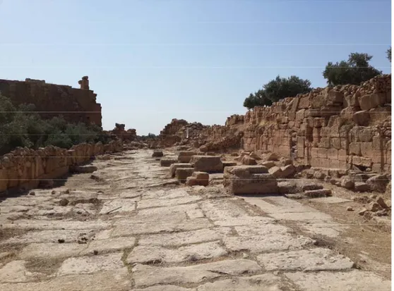
Figure 22: The ruins of the walls of Dara at the end of the main street…….…….… 104
Figure 23: Dara, sketch plan of the walled area…………..……… 105
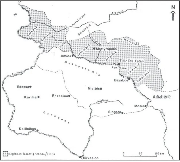
Figure 24: The Trans-Tigritane Provinces………..… 106
Figure 25: Roman Mesopotamia after the Peace of 299……….…… 107
Figure 26: Diocletian’s fortification route to the south in Syria, Strata Diocletiana.. 108
Figure 27: Location of Hatem-Tai castle (Rhabdion?)………...… 109
Figure 28: Sketch plan of Hatem-Tai castle (Rhabdion?)………...…… 109
Figure 29: Roman-Persian frontier in 387 and 591……….…… 110
Figure 30: The Tigris-Euphrates Archaeological Reconnaissance Project…….…… 111
Figure 31: Çattepe, general view of the mound during the excavations of 2013….…111 Figure 32: North-west tower of Çattepe. Above: view before the excavations began………...……… 112
Figure 33: Çattepe walls that have been unearthed over a length of ca. 200 m. in the western part facing the Tigris River………..… 112
Figure 34: The riverside storehouse from Çattepe. Above: view before the excavations began……….………….… 113
Figure 35: Coins from Çattepe. (a-b) Constantius II (AD 337-361); (c) Constantius Gallus (AD 351-354)………..…. 114
Figure 36: Inscribed altar from Çattepe………..… 114
Figure 37: A detailed aerial photo of Eski Hendek (Bezabde?)……….….… 115
Figure 39: Strategic location of Bezabde
Across from the Persian fortress Fenik (Phaenicha?)………...… 116 Figure 40: Contour map of Eski Hendek castle across from Fenik (Phaenicha?)….. 116 Figure 41: View of eastern walls of Eski Hendek castle……….……… 117 Figure 42: A bastion on the eastern side of Eski Hendek……...……… 117 Figure 43: An aerial photo showing the location of Üçtepe (Charcha)…………..… 118 Figure 44: Topographic plan of Üçtepe and the excavated areas………...… 118 Figure 45: Iron Helmet fragments from Üçtepe.
Below: the helmet after the Restoration……… 119 Figure 46: Late Roman coins from Üçtepe. First one is identified as
Julia Mamaea, second and third ones are busts of Gordian III
and Tranquillina, facing each other………..………… 119 Figure 47: Fragment of a Latin inscription from Üçtepe……… 120 Figure 48: Glass objects from Diyarbakır Museum collection………...… 120 Figure 49: Upper Tigris Archaeological Research Project
survey area and location of Körtik Tepe………...…… 121 Figure 50: The hypothetical contours of Late Antique Nisibis………...…… 122 Figure 51: The excavations located to the west of the Church of Mor Yakub……... 123 Figure 52: Excavations located to the south of the Church of Mor Yakub……….… 123 Figure 53: The western and southern façades of the Church of Mor Yakub……..… 124 Figure 54: Salvage excavations conducted in Ilısu Dam area……….…… 125 Figure 55: Ancient road of Hasankeyf and a Roman gateway……… 126 Figure 56: The excavation of the Great Palace in the Upper Town………...………. 126 Figure 57: Plan of the Great Palace...………..… 127 Figure 58: The Citadel Road and shops……….……….…… 127 Figure 59: Roman mosaics from Hasankeyf………...… 128
Figure 60: Salattepe, general view………..… 128
Figure 61: Kuriki Höyük, general view………..… 129
Figure 62: A building unit at Kuriki Höyük dated to the Roman-Parthian Period.… 130 Figure 63: Kuriki Höyük, the plan of the building unit…….……….… 130
Figure 64: Late Roman settlement at Ilısu Höyük………..…… 131
Figure 65: Ilısu Höyük, the plan of the settlement………..… 131
Figure 66: Parade masks from Ilısu Höyük………. 132
ABBREVIATIONS
Am. Marc.: Ammianus Marcellinus BAR: British Archaeological Reports BIAA: British Institute at Ankara ca.: Circa
Cf.: Confer
Ed. / Eds.: Editor / Editors e.g.: Exempli gratia
JRS: The Journal of Roman Studies ND Or.: Notitia Dignitatum Orients Obv.: Obverse
Rev.: Reverse Trans.: Translated
UTARP: Upper Tigris Archaeological Research Project ZPE: Zeitschrift für Papyrologie und Epigraphik
CHAPTER I
INTRODUCTION
“ ο9 de\ Seouh=roj a0ci/wma th|= Nisi/bei dou\j i9ppei= tau/thn e0pe/treyen, e1lege/ te mega/lhn te/ tina xw/ran proskekth=sqai kai\ probo/lhn au0th\n th=j Suri/aj pepoih=sqai.”
‘Severus bestowed some dignity upon Nisibis and entrusted the city to a Knight. He used to declare that he had added a vast territory to the empire and had made it a bulwark of Syria’.
Cassius Dio, History 60: 75 cf. Cary, E. 1989: 199 ***
According to Cassius Dio, Septimius Severus established the provinces of Osrhoene and Mesopotamia to better protect the rich and important province of Syria. With the exception of Trajan’s brief occupation of the region, Rome’s reach had never before stretched so far to the east but over the subsequent centuries the struggle with Persia for hegemony in the region would only intensify. While the accounts of the ancient historians have been well parsed and thoroughly analysed, they have not yet been fully supplemented or corroborated by archaeological findings in the region. For a
variety of reasons this part of Rome’s frontier has been the subject of too few researches, especially considering the outsized role that Persia played as Rome’s longest lasting enemy. This thesis seeks to join the available archaeological realities to the detailed historical information, and to shed new light on this critical period in Rome’s history.
1.1 Rome and Persia before Late Antiquity: An Overview
The ability of the Roman Empire to cope with changed circumstances on the borders was a consequence of a developed military strategy without any serious rivals in Classical Antiquity. In Late Antiquity, however, Rome faced an equal power to the east, Sasanians and while at the same time the barbarian tribes were causing difficulty to the north (Blockley, 1992: 165). For this reason, the creation of a properly fortified frontier in the east was essential for the Romans, which enabled them to confine conflicts between themselves and the Persians.
Comfort argues that “Before 363 on their eastern frontier the Romans never advanced to a line which permitted the easiest and most cost-effective defence of ‘their’ territory.” (Figure 1) (Comfort, 2008a: 230). Actually, although the struggle between Rome and Persia lasted for centuries, the borders between the two sides barely changed. There is a general agreement that it was broadly drawn along the line of the Middle and
Upper Euphrates before the early third century AD1 (Butcher, 2003: 32). The fact is, it
was already effectively established on this line in the Republican period, and became
this way in 96 BC thanks to the treaty arranged between Rome and Parthia by Sulla2, an
1 All dates AD unless otherwise specified.
event which is accepted as a turning point in the history of Rome’s relations with the Persians (Kallet-Marx, 1996: 335).
After Sulla’s death there followed “An extraordinary Roman offensive on a variety of fronts in the East that lasted for a decade and a half and convincingly established Rome’s military domination of the entire region.” (Kallet-Marx, 1996: 341). After the reorganisation of the East by Pompey, Rome for the first time expanded its influence in the territory beyond the Euphrates if not specifically in the region between the Middle Euphrates and the Middle Tigris (Magie, 1966: 371-373). The Roman hegemony that was established over Armenia and Osrhoene at the end of the Third Mithridatic War, however, conflicted with earlier treaties with the Parthians in which Sulla (in 96 BC) as well as Lucullus (in 69 BC) and Pompey himself (in 66 BC) agreed upon the Euphrates being the border delimiting the interest of the two powers (Ziegler, 1964: 20-32; Whittaker, 1970: 159-191). In 53 BC, however, M. Licinius Crassus, governor of the province of Syria, crossed the Euphrates and invaded Mesopotamia, intent on conquest and plunder, but instead got an expensive military answer at Carrhae (Harran) (Butcher, 2003: 36). After the disastrous battle in which the Emperor himself and thousands of Roman legionaries lost their lives, Rome lost its dominant position over Armenia and Osrhoene (Wagner, 1983: 104).
After the battle of Carrhae, it took nearly a hundred years until the Kingdom of Osrhoene again became of serious interest to Rome (Ziegler, 1964: 45-51). In 20 BC Augustus and the Parthians entered into an agreement again making the Euphrates the formal frontier (Ziegler, 1964: 45-51). “The reign of Augustus was the last great age of the Roman conquests” and he was not willing to extend any further the frontiers of the
empire (Millar, 1993b: 104). Thereafter, this policy of accepting the Euphrates as the formal frontier between Rome and Parthia was adopted by his successors until Trajan’s invasion of Armenia, Mesopotamia and down to the Persian Gulf in the war of 113-117 (Millar, 1993b: 104). Trajan’s campaigns in Mesopotamia confirmed the status of Osrhoene as a client kingdom and also transferred the city of Nisibis from the control of
Adiabene3 to Rome (Butcher, 2003: 45). Under his reign, thus, the empire reached its
greatest extent and restored Roman hegemony over Armenia and Osrhoene (Southern, 2001: 14; Butcher, 2003: 45; Wagner, 1983: 104). However, direct Roman control over Osrhoene only lasted until 118 when Trajan’s successor Hadrian abandoned this expansionist policy (Ross, 2001: 33) and withdrew from the conquered territory beyond the Euphrates and gave back to the Parthians all that Trajan had taken from them (Birley, 1999: 44).
A generation later, however, early in the reign of Marcus Aurelius and his co-Emperor Lucius Verus when the Parthians once again marched into Armenia and the Osrhoene, the Osrhoene dynasty showed a friendly disposition towards Rome (Wagner, 1983: 105). The resulting Parthian wars of Lucius Verus in 162-166 did little to change the established situation (Millar, 1993b: 104). “Obviously the successors of Trajan were not prepared to resume his policy of conquest but contended themselves with the protection of the frontier at the Euphrates” according to the strategic principles set in effect by of Pompey, Augustus, and Hadrian (Wagner, 1983: 105).
The Parthian Wars of Septimius Severus in 194-198 however saw a major change in Eastern Frontier policy, and resulted in the formation of a new province,
Mesopotamia, and the extension of Roman power to the Tigris (Millar, 1993b: 104; Butcher, 2003: 48). Under Severus the Euphrates was no longer the generally accepted frontier line lying between the two empires (Dillemann, 1962: 229). It was during Severus’ first period of campaigning in the region, in 194-195, that the former kingdom of Osrhoene, which had previously been a buffer state between Rome and Persia, became a Roman province (Wagner, 1983: 107), while Upper Mesopotamia was formed
into a Roman province later in 1994 (Figure 2). From this time, if not before, the area
between the Middle Euphrates and the Middle Tigris most certainly came under direct Roman control. In particular, the establishment of the province of Mesopotamia on a permanent basis beyond the Euphrates offers a clear example of Roman military expansionism in the region, a situation which would only continue in the later imperial period (Kennedy, 1979: 255; Millar, 1993a: 125-126). As will be explained, various emperors, especially Diocletian, Constantius II, and Julian were greatly involved in the region, and had to deal with the much more aggressive Sasanian dynasty, which had replaced the Parthian dynasty with the accession of Ardashir to the throne in 224. As a matter of fact the last form of the frontier line in the region which was established in the treaty of 363 did not change significantly for many centuries, despite some losses on each other’s territory by both sides (Figure 1) (Comfort, 2008a: 235) but under Anastasius I (491-518), this area became the flash-point for a major long-term struggle between Constantinople and Ctesiphon.
Rather surprisingly, despite its strategic significance in the relations between the Romans and the Persians throughout Late Antiquity, the area between the Middle
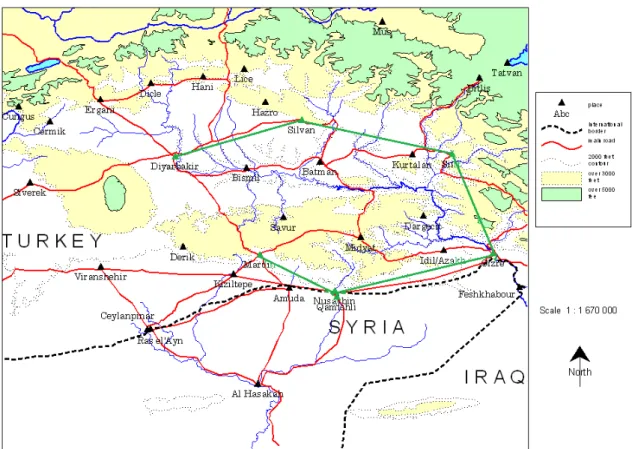
Euphrates and the Middle Tigris, roughly corresponding to the modern provinces of Şanlıurfa, Mardin, Western Diyarbakır, Western Şırnak, and Batman (Figure 3), is something of a forgotten borderland in the sense that it has rarely been the subject of serious academic enquiry. This thesis attempts to address that matter by reviewing the past work on the region and then, by using the results of more recent archaeological investigation, try to bring light to this forgotten part of the Roman Empire. Before going any further, however, it will be useful to sketch out the main details of earlier modern research into this topic.
1.2 The Present State of Research into the Region
According to Louis Dillemann, the first modern scholar who has examined this region in detail, one of the first and the best surveys of the region’s geography is
Lieut.-Colonel F.R. Maunsell’s Military Report on eastern Turkey in Asia.5 It would seem that
this contains a wealth of information about the social and physical geography of the area, and especially the third volume “The Tigris Valley: From the Persian Gulf towards Erzurum and Van” could have been very useful for locating and defining the existing Roman roads and forts. It was part of a series, but only one volume seems to have been preserved, which Louis Dillemann used in his own study, Haute Mésopotamie Orientale et Pays Adjacents, published in 1962. He describes the whole physical and human geography of Upper Mesopotamia in the relevant periods (Figure 4). He has many substantial discussions of ancient Roman routes and road networks.
5 Lieut.-Colonel F.R. Maunsell (1904) Military Report on Eastern Turkey in Asia. Today only Volume IV is available – “Middle Euphrates Valley: Country from the Gulf of Alexandretta towards Erzerum and Bitlis.” compiled for the Intelligence Department, War office.
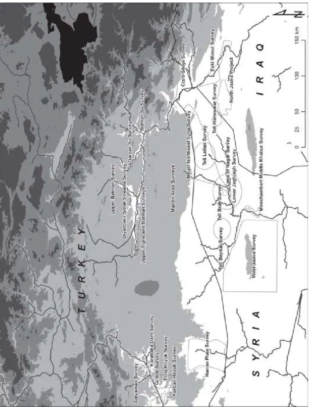
Apart from Maunsell and Dillemann, the surveys of the Tigris-Euphrates Archaeological Reconnaissance Project conducted by Guillermo Algaze and his colleagues between 1988 and 1990 in connection with the dam projects on the Euphrates and Tigris rivers are the most comprehensive researches in eastern Turkey recently (Figure 5). They have localized many prehistoric and protohistorical sites in the area including also a few that are Roman or Persian. They attribute the paucity of Roman sites in the area to the border dispute between Rome and Persia. But to say such a thing with any degree of certainty much more research needs to be done about the Roman or Sasanian structures and fortifications in the area.
In this respect, the long-term study of Tom Sinclair (1989), Eastern Turkey: An Architectural and Archaeological Survey, covers a broad area both in terms of geography and historical periods of the region and provides valuable knowledge of this rarely studied archaeological landscape. Direct personal knowledge obtained for the area has made possible for him to give the descriptions of many sites. He mainly concentrates on describing individual buildings. He establishes a basis of knowledge concerning the roads, bridges, fortifications and other structures in the region which may serve further research but mostly for the Mediaeval Period.
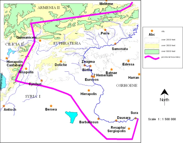
The last and perhaps the most comprehensive study on the subject matter examined in this thesis was the doctoral research undertaken by Anthony Martin Comfort in 2008. The published version of his thesis, ‘Roads on the frontier between Rome and Persia’, however, is basically concerned with the roads and communications in the three eastern provinces of the later Roman Empire; Euphratesia, Osrhoene and Mesopotamia from 363 to 602 (Figures 6-7). In his study, he examines the physical
evidence for the ancient bridges, cities and fortresses in the relevant regions, and pays particular attention to the roads. His study is a review of the remains of buildings of the period but he adds a new dimension to them by putting these roads in the context of the urban settlements. The field data he used is based on the results of his own fieldwork, conducted mainly around the upper reaches of the Tigris in conjunction with Google Earth satellite photographs around Zeugma on the Euphrates (Comfort, Reynal and Ergeç, 2000: 99-126; Comfort and Ergeç, 2001: 19-49), and he manages to place all roads and sites in a geographical context. His historical narrative is based on a study of the primary and secondary sources, but he does not include any summary of the political history of the region: rather he lays much more stress on the cultural affinities of the various centres. Even so, his work deserves admiration because there is no other synthesis covering the roads and fortresses in that large area.
These detailed surveys aside, the Eastern frontier provinces of the later Roman Empire have frequently been examined in broader detail by several modern scholars, most especially concerning where the exact line of Rome’s most eastern frontier ran. For
example, according to Ernst Honigmann6 the frontier between Rome and Persia between
363 and 603 was a line extending almost due north from Nisibis to the late Roman fortress of Cepha (Hasankeyf) and then following the Tigris west to a point opposite the junction with the Nymphius (Batman Su) (Figure 8) (Honigmann, 1935: 4-5). But according to Dillemann’s observations, this cannot be right. Several monasteries east of this line were “beneficiaries of largesse” from late Roman emperors such as Mar
6 Ernest Honigmann (1935) Die Ostgrenze des Byzantinischen Reiches von 363 bis 1071. Bruxelles: Editions de I'Institut de Philologie et d'Histoire Orientales.
Gabriel, the best known today (Dillemann, 1962: 229). Its construction was completed in 512 under Anastasius, after the construction of Dara (Palmer, 1990: 118). It is also known that the fortress of Rhabdion (Hatem Tai Castle?) remained in Roman possession after 363 when Nisibis was surrendered to the Persians (Comfort, 2008a: 236) and it remained under Roman control until 604/605 (Palmer, 1990: 151). Thus, Honigmann’s
idea of the frontier seems unrealistic.7
As it is, because of the difficult security situation in this region, which also hampered the studies of both Sinclair and Comfort, it is doubtful that any further comprehensive field research on the nature of this part of the Eastern frontier will be possible in the Middle Euphrates-Middle Tigris area in the near future. On the other hand, detailed fieldwork of limited parts of the region has been made possible within the scope of the on-going dam projects and especially the Ilısu dam. In fact many excavations associated with dam construction have been conducted recently in the area, but very few of the sites which contain Roman traces have received the attention that they deserve, a major exception being Tilli (Çattepe). Even so, the results from these sites reveal what might exist at other places. What is really needed, however, is the detailed excavation of the Roman phases of known Roman sites such as Amida (Diyarbakır) and Cepha (Hasankeyf).
What this means is that the study of the Middle Euphrates-Middle Tigris region must necessarily be incomplete, as what first seemed a very promising subject turned out to lack much of the data that was required. To be positive, however, this study will provide not just a history of the later Roman Empire with its militaristic stance towards
its neighbours in the east for the period from Septimius Severus to Anastasius I, but will critically assess and review recent relevant archaeological discoveries within the region. My aim, in other words, is to set the development of eastern Roman policy in the Upper Tigris region within the context of both the available historical and archaeological data in an attempt to better understand late Roman military policy and diplomacy on the borders towards the Persians.
CHAPTER 2
THE GEOGRAPHY AND ENVIRONMENT OF THE MIDDLE
TIGRIS BASIN AND TUR ABDIN REGION
To approach an understanding of how Rome perceived its Eastern frontier in the area between the Euphrates and Tigris we should first consider the region in general. In this chapter, therefore, I present an overview of the geographical characteristics of the Middle Euphrates and Mid Tigris area and briefly discuss the exact locations and the geopolitical positions of the cities in the region which feature in the border dispute between the Romans and the Persians.
2.1 The Upper Tigris Basin
Ancient Mesopotamia, surrounded by the Tigris and the Euphrates rivers and their tributaries, witnessed to the rise of many civilizations in history (Çevik, 2003: 105). Particularly the Tigris basin in the north and the northern section of the Mesopotamian plain in the south formed a very fertile region since very ancient times and encouraged the growth of population and trade (Sinclair, 1989: 161). In this respect, the Upper Tigris basin is one of the key locations for the interactions between Anatolia, Mesopotamia and Persia throughout history (Ferguson, 2005: 1).
The Tigris River itself originates from two sources in the Taurus Mountains and winds through deep canyons and narrow mountain gorges before flowing southwards past the city of Diyarbakır (Witchcraftt, 1999: 10). When it reaches the outlying foothills of the Mardin-Midyat limestone massif to the south, it is deflected eastwards, and flows on the northern edge of this massif, before turning south to finally enter the plain and flow south-east into Iraq (Sözer, 1969: 112; Sinclair, 1989: 161).
The interior of the Upper Tigris basin is a mostly treeless and generally undulating region, and much of it now under heavy cultivation (Sinclair, 1989: 161; Çevik, 2007: 105). It includes the cities of Amida (Diyarbakır), Martyropolis (Silvan),
Arzan and Cepha (Hasankeyf) which were crucial in the local history of Late Antiquity8
(Figure 10). This basin is delimited to the west by the extensive volcanic mass of Karaca Dağ, to the north and the east by the periphery of the southeastern Taurus range, and to the south by the Mardin-Midyat threshold (Çevik, 2007: 105). With these features, the region forms a geographical unit in itself (Sözer, 1969: 25-26).
2.2 The Tur Abdin
The Mardin-Midyat ridge, better known as the Tur Abdin, is an undulating limestone massif at a medium height stretching from the extensive volcanic mass of Karaca Dağ in the west to the valley divided by the Tigris River in the east (Çevik, 2007: 106). Most of this limestone massif consists of rocky hills intersected by small-scale valleys (Sinclair, 1989: 162). Since the Tur Abdin stands between the two natural
8 On the catalogue of sites from the Later Empire see Pollard (2000) Soldiers, Cities and Civilians in
corridors for trade and military invasion between the east and the west, it frequently witnessed the advance or retreat of one or other army in the struggle between Rome and Persia (Strabo 11.12.4 cf. Jones, 1924). It was sparsely populated, with two main centres
at Marde9 (Mardin) and Midyat (Çevik, 2007a: 141-143). This made it attractive to
early Christians who established churches and monasteries throughout this hilly country (Figure 11) (Sinclair, 1989: 162, 240). The first of these were founded in the late fourth century and most survived into the Early Islamic and Ottoman Periods (Sinclair, 1989: 162).
2.3 The Major Cities of the Region
Many of the cities of the region have been heavily occupied and reconstructed since the beginning of the Middle Ages and reached their present shape during a second wave of prosperity in the later Middle Ages (Sinclair, 1989: 161). The cities of Amida, Arzan and Martyropolis, which were strung out on the mediaeval trade route, and Cepha represent the major cities of the region in the relevant periods, while others like Nisibis (Nusaybin), later Dara and Mediaeval Dunaysir (Kızıltepe) represent the trading cities on the plain (Figure 10) (Sinclair, 1989: 161). Because control of the Upper Tigris basin was essential for the struggle between Rome and Persia, many fortified cities of the
region10, most importantly Amida and Nisibis have a continuous and active role in the
offensive and defensive policies of the Roman and Persian Empires in Late Antiquity (Isaac, 1990: 252).
9 Marde/Margdis/Mardoi? See Kroll, Roaf, Simpson, and Sinclair (2000: 89) “Map 89 C3” in R. J. A. Talbert, ed., Barrington Atlas of the Greek and Roman World. Princeton, NJ: Princeton University Press.
2.3.1 Amida (modern Diyarbakır)
The city of Diyarbakır stands on the west bank of the Tigris and north of the Tur Abdin (Millar, 1993a: 209). It lies on the primary east-west route that runs along the Tigris and at an intersection of the route coming from Malatya and Harput past Hazar Gölü in the Taurus Mountains (Sinclair, 1989: 164-165). The five and a half kilometer long city walls are heavily defended with large towers and present supposedly the longest mediaeval city-wall in existence (Figures 12-13) (Sinclair, 1989: 167).
The city was the most crucial military base in the region due to its strategic position (Honigmann, 1935: 2, 4) and therefore played a dominant role during the Later Roman and Byzantine Empires (Sinclair, 1989: 166; Pollard, 2000: 288). In the fourth century, the city was fortified by the emperor Constantius (Ammianus Marcellinus 18.9.1 cf. Pollard, 2000: 288), and became the leading city of the province of Mesopotamia (Çevik, 2007: 113). According to Ammianus, the purpose of the fortification was to provide the inhabitants and their countryside neighbours a secure place of refuge (Ammianus Marcellinus 18.9.1 cf. Millar, 1993a: 209). The city remained an important military centre until 363 when the Romans based legions at Amida and Cepha only (Sinclair, 1989: 370; Pollard, 2000: 288), and surrendered Nisibis to the Sasanians (Isaac, 1990: 252). After that time the population of the city was swollen by the immigrants from Nisibis and after the walls were completed it may have become the market centre for most of the west half of the Upper Tigris Basin (Sinclair, 1989: 371).
2.3.2 Maipa/Martyropolis/Ioustinianopolis (modern Silvan)
The city of Silvan, with part of its mediaeval walls still standing, lies along a route which descends from the Taurus Mountains and then continues south to cross the Tigris at Hasankeyf (Figures 14-15). Its early history is something of a mystery, but the Barrington Atlas identifies it with Maipa (Kroll, Roaf, Simpson, and Sinclair, 2000: 89 D2). Some scholars identify this place with the first century Armenian centre of
Tigranocerta11 (Holmes, 1917: 120-138). The fact is that the exact location of
Tigranocerta is still problematic (Karg, 1998: 246). Sinclair notes some good clues to Tigranocerta’s location that point to the Arzanene region (Sinclair, 1989: 361). For him, the possibility that Silvan is the site of Tigranocerta imposes some difficulties. For example, Tigranocerta is located on a river, and although there is a tributary of the river at some distance from Silvan to the South the present city is not on a river (Sinclair, 1989: 361-364).
After 363, when the Upper Tigris became the northern border separating the Roman Sophanene from the Sasanian Arzanene, Maipa was still the capital of the region (Figure 7) (Sinclair, 1989: 363). Around 410 it was re-founded as Martyropolis by the Syrian bishop Marutha (Nicholson, 1985: 668) and the region around it served as not merely a political borderland but as a border separating varied religious groups in the region (Karg, 1998: 246). From the late fourth to the late sixth century, Martyropolis was used as a base for concentrations of troops as was Dara (Procopius 3.2.11 cf. Dewing, 1940; Sinclair, 1989: 374). Because it was near the frontier and at a good
11 The Armenian king Tigranes the Great founded the city of Tigranocerta and introduced the first city to the Tigris Basin somewhere between the Tur Abdin and the Taurus Mountains and it was to be his capital (Sinclair, 1989: 361).
distance from Amida (Procopius 3.2.4 cf. Dewing, 1940), it was converted into a major military establishment and used as a base for several expeditions into Arzanene late in
the sixth century12 (Sinclair, 1989: 374). At that time it was known as Ioustinianopolis,
indicating a major rebuilding under the emperor Justinian (Syme and Birley, 1995: 56, 65).
2.3.3 Arzan/Erzen
What we learn from the literary sources is that Arzan was one of the centres in the Arzanene region (Çevik, 2008: 243). However, its exact location is not defined in either the Roman sources or those available for the Middle Ages, and it has not yet been located by modern scholarship (Çevik, 2008: 243). There is general agreement that the location was completely deserted by the later Middle Ages as otherwise it should be possible to identify its location from toponymic evidence (Sinclair, 1989: 164).
2.3.4 Cepha/Cephas (modern Hasankeyf)
Cepha is located on the bank of the Tigris just after it begins its bend to pass around the Tur Abdin (Sinclair, 1989: 162). The root of the modern name Hasankeyf refers to “Kipani" (rock) in Aramaic, a reference to the cliffs that dominate the location, and took the form of “Kefa” and “Kepha” in the Roman Period (Arık, 1999: 795). The place lies on the route from Amida to Cizre (Jazira) and thence Iraq (Sinclair, 1989: 231-232), thus as a place appropriate for passage across the Tigris it can be supposed that this location was settled from prehistoric times onwards (Arık, 1999: 795). It certainly
became one of the legionary bases on the north side of the Tur Abdin in Late Antiquity
(Sinclair, 1989: 370; Comfort, 2008a: 63). A fortification13 was built here by
Constantius II (324-361) and is probably where the later mediaeval town and castle stands, stretching back from the top of one of the cliffs cut by the Tigris to the valley (Figure 16) (Sinclair, 1989: 230; Miynat, 2008: 160). It is possible, however, that the legionary base occupied the flat area adjacent to the river crossing, a location now covered by the Lower Town of Hasankeyf (Arık, 1999: 795).
This place was one of the last surviving bases of the Roman superpower against Persia in Late Antiquity (Arık, 1999: 795; Comfort, 2008a: 42) and changed hands many times between the two empires (Miynat, 2008: 160). It was also a civilian city under the Late Roman Empire but reached its greatest prosperity under the Artukids in the late tenth and eleventh century as one of the magnificent centres of the region (Sinclair, 1989: 392-394). The major mediaeval monuments of Hasankeyf in the Castle area and in the Lower Town today represent a variety of the Early Islamic, Iranian-Seljuk and Roman-Byzantine cultural influences (Arık, 1999: 796; Comfort, 2008a: 63). The Castle area is now completely deserted, as is most of the Lower Town (Sinclair, 1989: 164) the part that will be inundated when the Ilısu Dam Project is completed.
2.4 Secondary Centres of the Region and the Trade Routes
Besides the four major cities above mentioned, several secondary centres of the Basin existed with an independent economic policies (Sinclair, 1989: 162).
13 It is questionable whether this fort was in what later became the upper town. See Honigmann (1935: 3) and Sinclair (1989: 370).
2.4.1 Eğil
One of the most substantial and important secondary centres was Eğil. The city was the capital of an Armenian Kingdom of Sophene and referred to as Carcathiocerta in the pre-Parthian period (Dillemann, 1962: 117; Sinclair, 1989: 162) and thus predated all of the nearby cities; the citadel of Eğil overlooked the western branch of the Tigris (Figures 17-18) (Dillemann, 1962: 121). It was evidently founded before Nisibis, and although placed on the route of the Persian royal road in the sixth century BC, it never became a real centre in the sense of trade or industry (Sinclair, 1989: 358).
2.4.2 Bezabde (modern Eski Hendek?)
The city of Bezabde was the capital of the district known as Zabdicene (Beth Zabday) (Sinclair, 1989: 365); records indicate uninterrupted settlement from the third century BC to the Classical Period (Laflı, 2012b: 16). But the exact location of Bezabde
is still problematic.14 For example, while many scholars such as Dillemann and
Hartmann, including also the travellers of the nineteenth century, located Bezabde usually in the centre of modern Cizre (Çevik, 2011: 1), for Sinclair the region Zabdicene appears to have been confined to the west bank of the Tigris River (Blockley, 1992: 22) and in the light of the literary sources the capital should have been the now deserted triangular site in the south-east of Cizre (Sinclair, 1989: 365). However, a more recent study by Çevik (2011), in the light of the studies of Lightfoot and Algaze (Lightfoot, 1983: 189-204; Algaze, 1989: 241-281), claims that the city which was one of the
important Roman garrisons in the Upper Tigris Basin is not located in or near Cizre15,
but rather should be sought 13 km north close to the village of Eski Hendek in the Idil region (Figure 19) (Pollard, 2000: 288, Çevik, 2011: 1).
It had been suggested that the city was a legionary base on the evidence of Ammianus, although this is not universally accepted (Isaac, 1990: 168). According to his
accounts, Bezabde was a very strong fortified city with three legions16 situated on a
fairly high hill and extending towards the bank of the Tigris (Ammianus Marcellinus 11.7 cf. Hamilton 2004: 193). It had the advantage of controlling both the approach to Nisibis and the way through the Tur Abdin (Figure 1) (Sinclair, 1989: 370). The city had come under the domination of Parthians in 129 BC and from 226 onward became a crucial point on one of the important routes between the Roman Empire and Mesopotamia (Laflı, 2012b: 17). Between the fourth and sixth centuries, the city of Bezabde and its vicinity played an active role in the border dispute between the Romans and Sasanians (Blockley, 1992: 22). In 363 it was captured by the Sasanians and between the fourth and sixth centuries they maintained control of the city and its vicinity (Isaac, 1990: 252; Laflı, 2012b: 17).
2.4.3 Nisibis (modern Nusaybin?)
Nisibis situated in Mardin province was one of the magnificent cities of the late Classical and the early Middle Ages (Figure 10) (Çevik, 2007: 141). Founded by Seleucus Nicator (312-281 BC), it was the first true city of the region in the pre-Parthian
15 See also Algaze G. et al., (2012: 42-45).
16 In the time of Constantine II Parthica was sent Bezabde and II Armeniaca and II Flavia came to help for the Persian war (Dando-Collins, 2010: 536). See also Ammianus Marcellinus (20.6.7 cf. Hamilton, 2004: 193).
period (Pollard, 2000: 286). Nisibis gained an important role because it provided the maintenance and expansion of the trade between Seleucia Pieria (Samandağ) and the Seleucid parts of Mesopotamia (Sinclair, 1989: 357-8). Nisibis retained its important trade position in the Late Roman period (Sinclair, 1989: 163). After Septimius Severus had organized the new province of Mesopotamia, he gave several cities including Nisibis colonial status (Jones, 1971: 220). Before that, it had probably been a Roman
military outpost17 (Isaac, 1990: 399).
Nisibis was clearly the central place in the eastern part of the Mesopotamian shelf (Millar, 1993a: 482) and to hold such a place meant an advantage to dominate on the commercial exchanges between the two empires (Millar, 1993a: 179). Thus, it became a crucial location in the struggle between Rome and Persia from the third to the sixth century and before 363 had frequently changed hands (Oppenheimer, Isaac, and Lecker, 1983: 319-334; Çevik, 2007: 141). Until it was surrendered to the Sasanians after the campaign of Julian in 363, for over sixty years Nisibis was the primary commercial and military centre responsible for all the legions of Roman Mesopotamia (Sinclair, 1989: 163; Millar, 1993a: 179). After its capture by the Sasanians, the population of Nisibis had to abandon the city and migrate to Amida (Lee, 1993: 58). From that time on, Rome kept trying to regain Nisibis until 505 when Anastasius built a new fort at Dara as an alternative military base to replace Nisibis (Figure 20) (Honigmann, 1935: 101). Under the early Arab occupation Nisibis became for a time the administrative centre of the whole region (Sinclair, 1989: 163).
17 See Dura Europos (Salihiyeh) in Kennedy and Riley (1990: 113): Nisibis and Dura Europos have several characteristics in common as a Seleucid colony, planned city, and military base.
2.4.4 Dara
Dara, known as a Byzantine settlement, was located just above the meeting of the escarpment with the plain (Sinclair, 1989: 219, 374), 20 kilometers north-west of the Persian base at Nisibis; it was built in the years 505-507 by Anastasius I to provide a strong forward base for the Roman army in its struggle against Persia (Ensslin, 1927: 342-347; Honigmann, 1935: 101) after which it became the residence of the Dux Mesopotamiae (the commander of the Byzantine forces in Mesopotamia) (Figures 21-23) (Croke and Crow, 1983: 146; Sinclair, 1989: 374). Thereby, it retained a crucial importance during the struggle between Rome and Persia in the sixth century (Isaac, 1990: 264). Dara remained also an important city during the Arab occupation, and was occupied until at least the late twelfth century (Sinclair, 1989: 219).
2.5 The Ancient Territories between the Middle Euphrates and the Middle Tigris The region between the Middle Euphrates and the Middle Tigris was historically divided into four regions which played a substantial role in the history of the struggle between Rome and Persia: Osrhoene, Upper Mesopotamia, Sophanene and Arzanene (Figure 24).
2.5.1 Osrhoene
The Hellenistic kingdom of Osrhoene, the region between the major source of the Khabur and the Euphrates (Segal, 1970: 164), became the province of Osrhoene following Septimius Severus’ first campaign against Parthia in ca. 196 (Segal, 1970: 45),
confining the power of the ruling Abgars18 to the city of Edessa (Şanlıurfa) and its
immediate environs (Segal, 1970: 164; Dodgeon and Lieu, 1991: 1). Although Osrhoene is stricto sensu outside the Tigris basin, it played a crucial role in the struggle between Rome and Persia before the third century, because of its strategically important position; therefore it stood in varying dependency of the powers of Armenia, Persia, and Rome (Wagner, 1983: 103). It remained as a Roman province until the invasion of the Arabs in
the 7th century (Segal, 1970: 164; Sinclair, 1989: 143).
2.5.2 Upper Mesopotamia
Although Upper Mesopotamia was formed into the province of Mesopotamia by Trajan (Millar, 1993a: 99); it kept this status a very short time because Hadrian withdrew from the areas of Mesopotamia and across the Tigris, and gave back to the Parthians all that Trajan had taken from them (Bennett, 2001: 203; Comfort, 2008a: 230). A new province of Mesopotamia was established in broadly the same area but extending further east by Septimius Severus in late 199, and became a major military province with two legions that came under a praefectus of equestrian rank (Millar1993a: 125). It was the most convenient region for access between Anatolia and Mesopotamia (Lee, 1993: 95). After the capture of Nisibis only the western part of Mesopotamia remained as a Roman province until the invasion of Arabs in the seventh century (Sinclair, 1989: 143; Segal, 1970: 164).
18 On the Abgar dynasty who ruled the Kingdom of Edessa and its vicinity see Segal (1970) Edessa, the
Blessed City. London: Oxford University Press. Or Turkish trans. by A. Arslan (2002), İstanbul: İletişim
2.5.3 Sophanene and Arzanene
The northern boundary of the province of Mesopotamia faced a series of
Armenian principalities, the so-called “Trans-Tigritane Provinces”19 (Comfort, 2008a:
273-274). Two of these, Sophanene and Arzanene were located in the area between the Tigris and the Taurus, where the cities of Amida and Maipa were located (Lee, 1993: 95).The Batman Su, one of the tributaries of the Tigris, divides this area north of the Tigris and Tur Abdin and south of the Taurus Mountains into the two territories of Sophanene and Arzanene (Redgate, 1998: 95); the first located to the west and opposite Diyarbakır and its vicinity, and Arzanene the area between Batman and Siirt (Figure 24) (Çevik, 2008: 243). Both principalities played an important role in the history of the border dispute between Rome and Persia and experienced regular interaction with both
in the course of events20 (Lee, 1993: 149). Although Sophanene is always attributed to
the Roman hegemony, it is not completely clear that the Roman boundary was ever on the eastern edge of Arzanene because it was given up to the Persia after the border arrangements in 363 (Figure 1) (Sinclair, 1989: 366).
19 The Trans-Tigritane Provinces comprise seven southern regions running roughly between the Kara Su and the Great Zab: Ingilene, Sophanene, Arzanene, Corduene, Zabdicene, Moxoene and Rehimene. See Dillemann (1962, Fig. 28) and Redgate (1998, Map 5.2 Armenia).
CHAPTER 3
THE CREATION AND HISTORY OF THE MIDDLE
TIGRIS FRONTIER
Severus claimed that he created a ‘bulwark of Syria’ through the establishment of the two Mesopotamian provinces, Osrhoene and Mesopotamia (Cassius Dio, 60: 75 cf. Butcher, 2003: 48). However, the Roman conquest of northern Mesopotamia resulted in several critical outcomes in the longer term (Isaac, 1990: 219). The devastating defeat of the Parthians ultimately triggered the rise of the Sasanian dynasty which was then able to take control of the Parthian Empire with its own expansionist policy (Kaçar, 2008: 7-8). This was in part due to the way that members of the Severan dynasty attempted to broaden Roman control over Mesopotamia (Watson, 1999: 6-7).
For example, Caracalla used a pretext to invade Parthia, and having defeated the Parthian army near Nisibis (Nusaybin), evidently planned to campaign further into Mesopotamia, plans that were cut short by his assassination in a palace coup half-way between Carrhae and Edessa (Brauer, 1995: 98). Macrinus, Caracalla’s praetorian prefect, was chosen to succeed him, but his new peace treaty with the Parthians was seen as a humiliating retreat for their army, and this, along with other factors, in the end resulted in an army rebellion that cost him his own life, and the acclamation of
Elagabalus, a grandson of Severus, as the new emperor (Butcher, 2003: 50). In the meantime the Parthian Kingdom gradually began to break apart in a series of rebellions
that starting in the thirdcentury (Watson, 1999: 6), especially those in the southern part
of Persia, allowed the rise of the Arsacid dynasty and a new power appeared on Parthian geography, the Sasanians (Frye, 1983: 117-18).
3.1 The Rise of the Sasanians and the Region during the First Half of the Third Century
The first Arsacid ruler, Ardashir I (224-241), regarded himself and his followers as the rightful inheritors of the Achaemenid Empire that had menaced the Greek world from the sixth to the fourth century BC (Yarshater, 1983: 116-117). Therefore, his objective and that of his successors, notably Shapur I (241-272), was always to acquire control of the whole of the Fertile Crescent together with Iran, the Levant, and Anatolia, and thus establish a new world-empire with themselves as the sole superpower (Butcher, 2003: 32-33). The Romans were aware of the fact that the Arsacid rulers might become a serious threat to their eastern territories, but the eventual arrival of the Sasanians brought a much more devastating army and military power than had previously erupted out of Persia (Watson, 1999: 7). Under Ardashir I and later his successor Shapur I, the Sasanians proved to be more aggressive and more adventurous than the Parthians (Southern, 2001: 233). Thus, the coming of the Sasanians changed the balance of power and opened a new chapter in the struggle for hegemony in the Near East (Redgate, 1998: 94). Moreover, for the first time in centuries Rome had to deal with an eastern foreign power that was determined to be its equal in military terms (Lee, 1993: 52).
Under these circumstances, the Sasanian Dynasty kept the Persian region more-or-less under its control throughout the next 400 years, from the first half of the third century towards the middle of the sixth century (Kaçar, 2008: 8). Thus, they now became a permanent threat for the Roman Empire in southern and southeastern Anatolia. Having radically changed the feudal character of the Parthian system of government, they established a more centralized kingdom in the East (Southern, 2001: 229-230; Kaçar, 2008: 9). Thus, they were able to use the resources of Mesopotamia and Iran better than the Parthians in their struggles with Rome (Isaac, 1990: 219).
By the time Severus Alexander took the imperial throne after the assassination of Elagabalus in 222 (Southern, 2001: 59), the Roman Empire had reached its greatest extent in the East (Butcher, 2003: 51). At that time, the Romans had reached as far as the Tigris and the middle reaches of the Euphrates and the army occupied almost all of upper Mesopotamia (Butcher, 2003: 51). According to the records of Dio and
Herodian21, at the time the Sasanian ruler Ardashir, who desired to control the entire
region over which their Achaemenian predecessors ruled, took the throne of Persia, he sent an ultimatum to Severus Alexander advising him to surrender Asia, the ancestral possession of the Persians (Rubin, 1975: 428-430). As part of the new expansionist policy of Ardashir, the Persians attacked the Mesopotamian city-state of Hatra in 229 and this inevitably brought conflict into the Roman frontier territory (Potter, 1990: 376; Southern, 2001: 61). In 230 Ardashir besieged Nisibis and entered Roman Mesopotamia (Butcher, 2003: 54). Despite Severus Alexander’s attempt at negotiation, Ardashir refused it and continued his campaign on the Roman frontiers (Herodian 6, 4, 4-6 cf.
Dodgeon and Lieu, 1991: 19-20; Butcher, 2003: 54). Thus, in 231/232 Severus Alexander attacked the Sasanian West in three columns; one directed to Armenia, one sent to Media and one directed at the Sasanian centre, the last commanded by the emperor himself (Whittaker, 1970: 102-103; Millar, 1993a: 150). The Roman army was successful in Media but Severus Alexander was defeated on the Euphrates (Potter, 1990: 379; Southern, 2001: 278).
This campaign really ended as a draw, partly because at the end of the 232 Severus Alexander had to leave the East for the Rhine and Danube regions as Roman supremacy in the West was in danger because “the Germans” had crossed the Rhine and Danube rivers and even threatened Italy, and therefore Severus Alexander had to withdraw from the East in 232/233 (Herodian 6, 7, 1-6 cf. Dodgeon and Lieu, 1991: 29; Southern, 2001: 62).
In brief, the major series of struggles between Rome and the Sasanians started with the Sasanians’ declaration to end Roman control of Anatolia (Kaçar, 2008: 10). Between 237 and 240 Ardashir invaded Mesopotamia and captured the cities of Carrhae (Harran), Nisibis, and Hatra (al-Hadr in Iraq) (Millar, 1993a: 150). In particular, the capture of Hatra gave the Sasanians a strategically advantageous position over north Mesopotamia (Millar, 1993a: 149-150). The death of Ardashir in 240 was not enough to stop the Sasanian attacks because his successor Shapur I was to prove even more vigorous than him in the struggles with Rome (Kaçar, 2008: 10).
3.2. The Second Half of the Third Century
Gordian III tried to counter the attacks which had been conducted by Ardashir I, and launched an expedition against Persia in 243 against his son Shapur (Yarshater, 1983: 125). He was initially very successful and even regained Carrhae and Nisibis, and then moved towards Asorestan (the province of Assyria-Babylonia under the Sasanian Empire, 226-640) (Butcher, 2003: 54, 381). In 244, however, Shapur gained a decisive victory over the Romans and the emperor died on the battle field (Macdermot, 1954: 80). Soon after his successor Philip the Arab was forced to arrange a peace treaty with Shapur that was extremely generous for the Sasanians (Macdermot, 1954: 80). As a result of this Rome not only experienced a financial loss but also lost its influence over Armenia (Baynes, 1910: 626). Shapur’s triumph over the Romans continued with the conquests of Antiochia (Antakya) and the other Syrian cities (Millar, 1993a: 160). Furthermore, in 260, Shapur defeated the Roman army once more under the command of Valerian, somewhere near Edessa, capturing the emperor along with some of his major
commanders22 (Butcher, 2003: 58). The capture of Valerian was an unprecedented event
and the severest humiliation for Rome (Kaçar, 2008: 11). For the peoples of Persia, Shapur’s triumph over these three emperors meant an end of the centuries of Persian humiliation at the hands of the Romans (Macdermot, 1954: 80).
During the mid- and later third century, in addition to the Sasanians, the Roman Empire faced a number of unprecedented challenges along the Rhine and Danube, as well as frequently being split by civil wars, and the formation of the Gallic Empire, and
22 Shapur’s triumph over the three emperors; Gordian III, Philip the Arab and Valerian, is shown on a trilingual inscription in the Ka’ba-ye Zardosht at Naqsh-i Rustam in Iran. For more detail see Daryaee (2009: 6-8); and Macdermot (1954: 77-80).
the actions taken by provincial rulers or Roman governors in the East have to be seen in that context (Blockley, 1992: 172). Before Aurelian, the Palmyrenes had proven to be loyal upholders of Roman interests in the region (Long, 1996: 61-62). Palmyra’s location between Rome and Persia meant that in peaceful times it prospered as a centre for trade (Long, 1996: 61-62). During the second century, the Romans stationed a garrison at Palmyra, although it remained a free city at the direction of Hadrian (Richmond, 1963: 54). By the third century, however, Palmyra had become more closely allied with Rome, and their ruler Odaenathus was considered a member of the Roman senate and was possibly the governor of Roman Syria (Richmond, 1963: 52; Butcher, 2003: 58).
In 260, following the capture of Valerian, Odaenathus aggressively defended the Roman prerogative in the east, dispatching the usurper Quietus at Emesa and leading successful campaigns in Persian territory (Long, 1996: 62). As a result of his success, Odaenathus was given unprecedented titles by the emperor Gallienus (Long, 1996: 63). But after his death his widow Zenobia and her son Vaballathus established their own eastern empire on par with the Gallic Empire in the West (Millar, 1993a: 172-73; Butcher, 2003: 58-59). While Odaenathus had impressive success against the Persians and quite likely preserved Rome’s eastern frontier, Aurelian did not consider Zenobia or her and Odaenathus’ son to be his equal (Butcher, 2003: 59). Naturally, once Aurelian had restored the threatening situation in Europe, the emperor sought to reassert undeniable Roman dominance in the Eastern provinces and defeated Zenobia and her son and destroyed Palmyra (Butcher, 2003: 60; Potter, 2004: 270-72). That said, at a later date Diocletian recognized the importance of the location and established a
legionary garrison there, but while the city enjoyed a modest revival in prosperity, it would never regain such a prominent position again (Richmond, 1963: 48, 54; Butcher, 2003: 61).
After the death of the Sasanian King Shapur in 272, a period of civil strife followed in the Persian Empire giving the Romans an opportunity to strengthen their eastern strategy (Frye, 1983: 127-28). Carus decided to take advantage of this turbulence in Persia and launched an expedition against the Sasanians, and achieved some initial successes before his death in 283 (Mitchell, 2007: 45; Cameron, 1993: 31). These were the first fully successful military actions of the Roman Empire against the Sasanian threat from the east (Butcher, 2003: 61; Eadie, 1996a: 73). However, after the death of Carus during his campaign, his successor Numerian could not maintain Rome’s position over the Sasanian regime. Numerian decided to withdraw from the region, and according to Malalas, this allowed the Sasanians to lay siege to Carrhae (Malalas, 12, pp. 303, 5-305, 2 cf. Dodgeon and Lieu, 1991: 118). In 284, while on his return to the West, where his older brother Carinus was in power at Rome, he was taken ill and died somewhere to the east of Nicomedia.
After Numerian’s death the Roman army elected Diocletian as its new leader (Eadie, 1996a: 73; Corcoran, 1996: 5). The following year he arrived into the Balkans and campaigned against Numerian’s brother Carinus, ruler in the west (Corcoran, 1996: 5). During the battle Carinus was assassinated, and Diocletian became the sole Emperor (Southern, 2001: 133). Within a matter of months, Diocletian appointed Maximian to rule the west, first as Caesar and then in 286 as Augustus (Corcoran, 1996: 5), the new emperor realised that the greatest threat came from the east and so he should remain in
that area. Diocletian also realised the empire was too large and faced too many threats for two co-emperors to deal with. Thus, in 293, the first tetrarchy was formed when two Caesares were appointed23, Galerius who served in the East under Diocletian and Constantius who served in Gaul under Maximian (Millar, 1993a: 177).
About 288, Diocletian placed Tiridates, an Arsacid prince, on the throne of Armenia and Vahram II (276-293), the Sasanian ruler, by his inaction acquiesced to Diocletian’s action (Yarshater, 1983: 128). Sasanian control in that time had probably become weakened over some sections of Armenia (Redgate, 1998: 113). It was weakened further because civil strife followed in the Persian Empire after the death of Vahram II in 293 and his son Vahram III ruled the Sasanian Empire for a very brief period in 293 until his uncle Narseh (293-303) replaced him and consolidated his position on the throne (Yarshater, 1983: 128). Narseh was determined to regain the territory that Rome had taken immediately after the death of Shapur I and during the reign of Vahram II and attacked Armenia and Mesopotamia (Kaçar, 2008: 12; Yarshater, 1983: 130). He deposed Tiridates in 296 and defeated a Roman army under Galerius in 297 and thus the Sasanians once more became the superior power in Mesopotamia and Armenia (Barnes, 1982: 55). Even so, this victory did not last long as in the following year Galerius entered Armenia with his rebuilt army and defeated the Sasanians at Satala near modern Erzincan and captured both Nerseh’s treasury and his family (Blockley, 1992: 5).
23 The tetrarchy comprises of two Augusti and two Caesar, only functioned from 293 to 306. It ceased entirely once all the rulers held the full rank of Augustus by 310. See Corcoran (1996: 5-9). For more detailed account of the whole period of 284-324, see Barnes (1982) The New Empire of Diocletian and
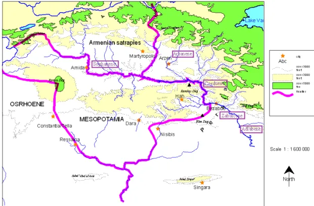
In 298, Diocletian joined Galerius in Nisibis and they decided to respond to the Persian peace overtures, which Galerius had earlier rejected (Blockley, 1992: 5). Although, Rome had lost many eastern regions in the third century, the emperors Diocletian and Galerius, with this treaty, brought this series of territorial losses to an end and even regained some (Butcher, 2003: 61). Under the terms of this treaty, the Romans regained control of Amida, Nisibis, Singara and Bezabde (Kaçar, 2008: 13) and gained indirect rule over Mesopotamia and Armenia, without military occupation (Millar, 1993a: 178). In this way they not only increased the Roman presence in the region but also obtained additional land beyond the Tigris River (Yarshater, 1983: 130). Both sides agreed that five districts – Intelene, Sophene, Arzanene, Carduene and Zabdicene – lying largely on the far bank of the Tigris, were to be held by the Romans and that the Tigris River was to be a borderland between the two empires (Figure 25) (Winter, 1989: 555; Blockley, 1992: 5-6). Furthermore, Nisibis was to be the sole trading post between the two powers and the Armenian satrapies were left independent but were considered Roman dependencies (Blockley, 1992: 6). For the Romans, this treaty was both a diplomatic triumph and a rectification of the humiliations they had endured since the capture of Valerian (Kaçar, 2008: 13).
Diocletian intended the treaty to ensure a lasting peace with the Sasanians (Eadie, 1996a: 79). He was clearly aware that Rome’s power was not infinite, and so he created a new frontier system in the region (Millar, 1993a: 180). Rather than base his soldiers in their former camps, he built new forts along the roads themselves (Eadie, 1996a: 76). He started a recovery program including the construction of new forts from
Diyarbakır down the Upper Tigris24 (Millar, 1993a: 180). He made the provincial
administration more efficient and he tried to bring the ruinous inflation of the third century under control (Butcher, 2003: 61). In this general context of reform, the construction of roads can be seen as one more attempt to re-establish peace and normalcy in the Roman Empire rather than a new strategy to deal with the possibility of
invading Sasanian territory or to provide advanced warnings of a Persian invasion25
(Eadie, 1996a: 76).
For the Persians, the treaty resolved nothing and for Nerseh himself, approving this treaty was nothing more than a humiliation which threatened his western territories and diminished his prestige in the eyes of the Persian nobility (Blockley, 1992: 7). For this reason, when it was due for renewal Nerseh and even his successor Hormizd refused to renew it without, or so it seems, any major Roman objection (Barnes 1982: 62, 76; Blockley 1992: 7).
In conclusion, during the third century, Rome's eastern regions suffered greatly from Sasanian attacks, during which control of Nisibis, the key fortress on the Roman side of the Upper Mesopotamian Plain, and the adjacent region was lost (Bowman, 2008: 88). After the chaos of the third century, however, the Roman Empire took a defensive stand against Persia which was effective but extremely costly to maintain (Blockley, 1992: 165). It continued to suffer from the pressure both from the Barbarians
24 There is almost no evidence of an immediate policy of fortification in Mesopotamia and Osrhoene; that seemingly comes only later during the reign of Constantius II. As for Diocletian, solid archaeological evidence only exists for his fortifications to the south in Syria, the so-called Strata Diocletiana (Figure 26). See van Berchem (1952) and Butcher (2003).
25 According to the historical accounts of Ammianus Marcellinus (who served as a soldier on the eastern frontier in the 350s and 360s), Diocletian’s work of fortification was part of a wider policy in order to prevent the Persians from overrunning Mesopotamia. See Dodgeon and Lieu (1991: 121-133) and Matthews (2007: 549-564).